
Southern Uplands
Encyclopedia
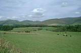
The Southern Uplands are the southernmost and least populous of mainland Scotland
's three major geographic areas (the others being the Central Lowlands
and the Highlands
). The term is used both to describe the geographical region and to collectively denote the various ranges of hills within this region. The Southern Uplands lie south of the Southern Uplands Fault
line that runs from Ballantrae
on the Ayrshire
coast northeastwards to Dunbar
in East Lothian
on the North Sea
coast, a distance of some 220 km (136.7 mi). In geological terms, the Southern Uplands consist mainly of Silurian
deposits laid down from 400-500 million years ago and pushed up from the sea bed by the collision of ancient continents. The majority of the rocks are weakly metamorphosed coarse greywacke
. An overwhelmingly rural and mainly agricultural region, the Southern Uplands are partly forested and contain many areas of open moorland.
The two unitary authorities
of Dumfries and Galloway
in the west
and the Scottish Borders
in the east cover almost all of the Southern Uplands. Along its northern margins, the councils of South Ayrshire
, East Ayrshire
, South Lanarkshire
and East Lothian
extend into the region. After local government reorganisation in 1974 and prior to further reorganisation in 1996, the Southern Uplands were administered by the two 'regions' of Dumfries & Galloway and Borders along with the southern margins of the regions of Strathclyde and Lothian. Within each of these regions were districts with their own district councils. Historically, i.e. prior to 1974, the region comprised the counties of Wigtown
, Kirkcudbright
, Dumfries
, Roxburgh
, Peebles
, Selkirk
and Berwick
together with parts of Ayrshire
, Lanarkshire
, Midlothian
and East Lothian
.
s.
Some of the more notable peaks in the Southern Uplands are:
The Southern Uplands are home to the UK's highest village, Wanlockhead
, 430 m (1,410.8 ft) above sea level.
at 106 mi (170.6 km) and the River Tweed
at 97 mi (156.1 km) respectively. Several significant rivers drain southwards into the Solway Firth and Irish Sea including (from west to east) the River Cree
, River Dee
, River Nith
, River Annan
and the River Esk
.
There are numerous loch
s in the Southern Uplands, particularly in the west. The largest is Loch Ken
which arises from the damming of the Water of Ken
. Several other lochs in Galloway are dammed such as Loch Doon
, Loch Bradan and Clatteringshaws Loch
though many smaller ones remain in a more natural state such as Loch Dee, Loch Enoch
, Loch Grannoch and Loch Trool
.
To the east of Moffat is the largest natural body of water in the Southern Uplands, St. Mary's Loch together with the adjacent Loch of the Lowes
and nearby Loch Skeen
. There are several other reservoirs in the vicinity including Megget Reservoir
, Talla Reservoir
and Fruid Reservoir whilst Daer Reservoir
lies among the Lowther Hills.
and red grouse
, mountain hares, raptors
such as golden eagles and hen harriers, and some unusual plant species. The western hills are home to red deer
, roe deer
and feral goats. The western forests have one fifth of the Scottish population of red squirrels. Ospreys are present at St Mary's Loch
and along the River Tweed
. Brown trout
are common in many burns and a number of the rivers in the area have populations of sea trout, salmon
and otters.
was built between 1930 and 1936. More recently a number of wind farms have been developed on upland sites. Tourism and recreation are of increasing importance: walking, fishing and grouse shooting are traditional pursuits and mountain biking has become popular in recent years.
The textile industry employed large numbers in many of the towns of the Scottish Borders in the 19th and 20th centuries. Stocking frames were introduced in Hawick
in 1771 and Galashiels
' first woollen mill was built in 1800, but textile manufacture had a long history in the area: linen production had been a major industry since the middle ages. The textile industry declined in the late 20th century, with 7,800 people employed in 1981 and only 4,400 by 1998. However, it continues to be significant both to the local economy and to that of Scotland in general.
to the east, while dairy farming is traditionally more important in Dumfries and Galloway
, although recent years here have seen a move away from cattle grazing towards sheep farming. Several breeds of livestock have originated in the Southern Uplands, including Galloway cattle
, Ayrshire dairy cattle
and Cheviot sheep
.
The amount of forested land cover in the western Southern Uplands increased greatly between the 1940s and the 1980s, from 1% to 23%.
of Scotland and England to the south. Major roads and railways follow the east coast route and various valley routes radiating northwards from the Carlisle area.
, Glasgow International Airport
and Edinburgh Airport
.
Vehicle ferries operate between Stranraer and Cairnryan
in Scotland and Belfast
and Larne
in Northern Ireland
respectively.
, a 212 miles (341.2 km) coast to coast walk between Portpatrick
in the west and Cockburnspath
in the east.
, Merrick
and Cairnsmore of Fleet
.
are seven mountain biking
centres spanning the south of Scotland, from the heart of the Scottish Borders to Dumfries and Galloway. They are on Forestry Commission
land and along with schemes in Wales are regarded as the benchmark by which further trails in the UK should be developed. They are known as the 7stanes because each venue features a 'stane' (Scots
for stone) somewhere along the forest trails.
The Seven Stanes:
, the Battle of Nesbit Moor
and the Battle of Philiphaugh
. The Common Riding
festivals of many Southern Upland towns such as Jedburgh
, Kelso, Hawick
, Peebles
, Selkirk
and Langholm
recall this history, re-enacting the practice of riding the boundaries of the town to enable warning to be given of raids from the south.
This violent history is also commemorated in many Border ballad
s, another common theme of which is the supernatural, as in the ballads of Thomas the Rhymer
and Tam Lin
. Many Border ballads were collected by Sir Walter Scott
in his Minstrelsy of the Scottish Border. Scott also portrayed the social history, folklore and traditions of the Southern Uplands in several of his prose and verse works (such as The Lay of the Last Minstrel), as did James Hogg
, known as the Ettrick
Shepherd.
Scotland
Scotland is a country that is part of the United Kingdom. Occupying the northern third of the island of Great Britain, it shares a border with England to the south and is bounded by the North Sea to the east, the Atlantic Ocean to the north and west, and the North Channel and Irish Sea to the...
's three major geographic areas (the others being the Central Lowlands
Central Lowlands
The Central Lowlands or Midland Valley is a geologically defined area of relatively low-lying land in southern Scotland. It consists of a rift valley between the Highland Boundary Fault to the north and the Southern Uplands Fault to the south...
and the Highlands
Scottish Highlands
The Highlands is an historic region of Scotland. The area is sometimes referred to as the "Scottish Highlands". It was culturally distinguishable from the Lowlands from the later Middle Ages into the modern period, when Lowland Scots replaced Scottish Gaelic throughout most of the Lowlands...
). The term is used both to describe the geographical region and to collectively denote the various ranges of hills within this region. The Southern Uplands lie south of the Southern Uplands Fault
Southern Uplands Fault
The Southern Uplands Fault is a fault in Scotland that runs from Girvan to Dunbar on the East coast. It marks the southern boundary of the Scottish Midland Valley....
line that runs from Ballantrae
Ballantrae
Ballantrae is a community in Carrick, South Ayrshire, Scotland. The name probably comes from the Scottish Gaelic Baile na Tràgha, meaning the "town by the beach"....
on the Ayrshire
Ayrshire
Ayrshire is a registration county, and former administrative county in south-west Scotland, United Kingdom, located on the shores of the Firth of Clyde. Its principal towns include Ayr, Kilmarnock and Irvine. The town of Troon on the coast has hosted the British Open Golf Championship twice in the...
coast northeastwards to Dunbar
Dunbar
Dunbar is a town in East Lothian on the southeast coast of Scotland, approximately 28 miles east of Edinburgh and 28 miles from the English Border at Berwick-upon-Tweed....
in East Lothian
East Lothian
East Lothian is one of the 32 council areas of Scotland, and a lieutenancy Area. It borders the City of Edinburgh, Scottish Borders and Midlothian. Its administrative centre is Haddington, although its largest town is Musselburgh....
on the North Sea
North Sea
In the southwest, beyond the Straits of Dover, the North Sea becomes the English Channel connecting to the Atlantic Ocean. In the east, it connects to the Baltic Sea via the Skagerrak and Kattegat, narrow straits that separate Denmark from Norway and Sweden respectively...
coast, a distance of some 220 km (136.7 mi). In geological terms, the Southern Uplands consist mainly of Silurian
Silurian
The Silurian is a geologic period and system that extends from the end of the Ordovician Period, about 443.7 ± 1.5 Mya , to the beginning of the Devonian Period, about 416.0 ± 2.8 Mya . As with other geologic periods, the rock beds that define the period's start and end are well identified, but the...
deposits laid down from 400-500 million years ago and pushed up from the sea bed by the collision of ancient continents. The majority of the rocks are weakly metamorphosed coarse greywacke
Greywacke
Greywacke or Graywacke is a variety of sandstone generally characterized by its hardness, dark color, and poorly sorted angular grains of quartz, feldspar, and small rock fragments or lithic fragments set in a compact, clay-fine matrix. It is a texturally immature sedimentary rock generally found...
. An overwhelmingly rural and mainly agricultural region, the Southern Uplands are partly forested and contain many areas of open moorland.
Local government
- main article: Local government in Scotland
The two unitary authorities
Unitary authority
A unitary authority is a type of local authority that has a single tier and is responsible for all local government functions within its area or performs additional functions which elsewhere in the relevant country are usually performed by national government or a higher level of sub-national...
of Dumfries and Galloway
Dumfries and Galloway
Dumfries and Galloway is one of 32 unitary council areas of Scotland. It was one of the nine administrative 'regions' of mainland Scotland created in 1975 by the Local Government etc. Act 1973...
in the west
and the Scottish Borders
Scottish Borders
The Scottish Borders is one of 32 local government council areas of Scotland. It is bordered by Dumfries and Galloway in the west, South Lanarkshire and West Lothian in the north west, City of Edinburgh, East Lothian, Midlothian to the north; and the non-metropolitan counties of Northumberland...
in the east cover almost all of the Southern Uplands. Along its northern margins, the councils of South Ayrshire
South Ayrshire
South Ayrshire is one of 32 council areas of Scotland, covering the southern part of Ayrshire. It borders onto East Ayrshire, North Ayrshire and Dumfries and Galloway....
, East Ayrshire
East Ayrshire
East Ayrshire is one of 32 council areas of Scotland. It borders on to North Ayrshire, East Renfrewshire, South Lanarkshire, South Ayrshire and Dumfries and Galloway...
, South Lanarkshire
South Lanarkshire
South Lanarkshire is one of 32 unitary council areas of Scotland, covering the southern part of the former county of Lanarkshire. It borders the south-east of the city of Glasgow and contains many of Glasgow's suburbs, commuter towns and smaller villages....
and East Lothian
East Lothian
East Lothian is one of the 32 council areas of Scotland, and a lieutenancy Area. It borders the City of Edinburgh, Scottish Borders and Midlothian. Its administrative centre is Haddington, although its largest town is Musselburgh....
extend into the region. After local government reorganisation in 1974 and prior to further reorganisation in 1996, the Southern Uplands were administered by the two 'regions' of Dumfries & Galloway and Borders along with the southern margins of the regions of Strathclyde and Lothian. Within each of these regions were districts with their own district councils. Historically, i.e. prior to 1974, the region comprised the counties of Wigtown
Wigtownshire
Wigtownshire or the County of Wigtown is a registration county in the Southern Uplands of south west Scotland. Until 1975, the county was one of the administrative counties used for local government purposes, and is now administered as part of the council area of Dumfries and Galloway...
, Kirkcudbright
Kirkcudbrightshire
The Stewartry of Kirkcudbright or Kirkcudbrightshire was a county of south-western Scotland. It was also known as East Galloway, forming the larger Galloway region with Wigtownshire....
, Dumfries
Dumfriesshire
Dumfriesshire or the County of Dumfries is a registration county of Scotland. The lieutenancy area of Dumfries has similar boundaries.Until 1975 it was a county. Its county town was Dumfries...
, Roxburgh
Roxburghshire
Roxburghshire or the County of Roxburgh is a registration county of Scotland. It borders Dumfries to the west, Selkirk to the north-west, and Berwick to the north. To the south-east it borders Cumbria and Northumberland in England.It was named after the Royal Burgh of Roxburgh...
, Peebles
Peeblesshire
Peeblesshire , the County of Peebles or Tweeddale was a county of Scotland. Its main town was Peebles, and it bordered Midlothian to the north, Selkirkshire to the east, Dumfriesshire to the south, and Lanarkshire to the west.After the local government reorganisation of 1975 the use of the name...
, Selkirk
Selkirkshire
Selkirkshire or the County of Selkirk is a registration county of Scotland. It borders Peeblesshire to the west, Midlothian to the north, Berwickshire to the north-east, Roxburghshire to the east, and Dumfriesshire to the south...
and Berwick
Berwickshire
Berwickshire or the County of Berwick is a registration county, a committee area of the Scottish Borders Council, and a lieutenancy area of Scotland, on the border with England. The town after which it is named—Berwick-upon-Tweed—was lost by Scotland to England in 1482...
together with parts of Ayrshire
Ayrshire
Ayrshire is a registration county, and former administrative county in south-west Scotland, United Kingdom, located on the shores of the Firth of Clyde. Its principal towns include Ayr, Kilmarnock and Irvine. The town of Troon on the coast has hosted the British Open Golf Championship twice in the...
, Lanarkshire
Lanarkshire
Lanarkshire or the County of Lanark ) is a Lieutenancy area, registration county and former local government county in the central Lowlands of Scotland...
, Midlothian
Midlothian
Midlothian is one of the 32 council areas of Scotland, and a lieutenancy area. It borders the Scottish Borders, East Lothian and the City of Edinburgh council areas....
and East Lothian
East Lothian
East Lothian is one of the 32 council areas of Scotland, and a lieutenancy Area. It borders the City of Edinburgh, Scottish Borders and Midlothian. Its administrative centre is Haddington, although its largest town is Musselburgh....
.
Hill ranges
There are several ranges of hills within the Southern Uplands. From east to west these are:- Cheviot HillsCheviot HillsThe Cheviot Hills is a range of rolling hills straddling the England–Scotland border between Northumberland and the Scottish Borders.There is a broad split between the northern and the southern Cheviots...
straddling the eastern end of the Anglo-Scottish borderAnglo-Scottish borderThe Anglo-Scottish border is the official border and mark of entry between Scotland and England. It runs for 154 km between the River Tweed on the east coast and the Solway Firth in the west. It is Scotland's only land border...
. - Lammermuir HillsLammermuir HillsThe Lammermuir Hills, usually simply called the Lammermuirs , in southern Scotland, form a natural boundary between Lothian and the Scottish Borders....
south of DunbarDunbarDunbar is a town in East Lothian on the southeast coast of Scotland, approximately 28 miles east of Edinburgh and 28 miles from the English Border at Berwick-upon-Tweed....
. - Moorfoot HillsMoorfoot HillsThe Moorfoot Hills are a range of hills south of Edinburgh in east central Scotland, UK, one of the ranges which collectively form the Southern Uplands.The Hills run from Peebles, Scottish Borders, in a north easterly direction to Tynehead, Midlothian....
south of EdinburghEdinburghEdinburgh is the capital city of Scotland, the second largest city in Scotland, and the eighth most populous in the United Kingdom. The City of Edinburgh Council governs one of Scotland's 32 local government council areas. The council area includes urban Edinburgh and a rural area...
. - Tweedsmuir or Manor Hills south of TweedsmuirTweedsmuirThe village of Tweedsmuir is a village and civil parish situated from the source of the River Tweed, in the Scottish Borders area of Scotland....
. - Culter Hills south of BiggarBiggar- Places :* Biggar, Cumbria, England* Biggar, Saskatchewan, Canada* Biggar, South Lanarkshire, Scotland- Electoral districts :* Biggar , provincial electoral district since 2002...
. - Moffat HillsMoffat HillsThe Moffat hills are a range of hills in the Southern Uplands of Scotland. They form a distinctly triangular shape with a west facing side, a north facing side, and a south-east facing side. It is 17 kilometres from east to west across this triangle and some 16 kilometres north to south...
north-east of MoffatMoffatMoffat is a former burgh and spa town in Dumfries and Galloway, Scotland, lying on the River Annan, with a population of around 2,500. The most notable building in the town is the Moffat House Hotel, designed by John Adam...
. - Ettrick Hills south of Moffatdale.
- Lowther HillsLowther HillsThe Lowther Hills, also sometimes known as the Lowthers, are an extensive area of hill country in the Southern Uplands of Scotland, though some sub ranges of hills in this area also go under their own local names - see "Hill Walking" below. They form a roughly rhomboidal or lozenge shape on the map...
between ClydesdaleClydesdaleClydesdale was formerly one of nineteen local government districts in the Strathclyde region of Scotland.The district was formed by the Local Government Act 1973 from part of the former county of Lanarkshire: namely the burghs of Biggar and Lanark and the First, Second and Third Districts...
/Annandale and NithsdaleNithsdaleNithsdale , also known by its anglicised gaelic name Strathnith or Stranit, is the valley of the River Nith in Scotland, and the name of the region...
. - Carsphairn and Scaur HillsCarsphairn and Scaur HillsThe Carsphairn and Scaur hills are the western and eastern hills respectively of a hill range in the Southern Uplands of Scotland. Ordnance Survey maps don't have a general name for the hill area as a whole. Also, Ordnance Survey use "Scar" rather than the local spelling of "Scaur" - the word is...
between Nithsdale and the Glenkens. - Galloway HillsGalloway HillsThe Galloway hills are part of the Southern Uplands of Scotland, and form the northern boundary of western Galloway. They lie within the bounds of Galloway Forest Park, an area of some of largely uninhabited wild land, managed by the Forestry Commission...
west of the Glenkens. This is a large hill area lying between Loch DoonLoch DoonLoch Doon is a body of water, in Carrick, Scotland. The River Doon issues from its northern end, while the loch itself receives waters from Loch Enoch via Eglin Lane....
in the north and the Solway FirthSolway FirthThe Solway Firth is a firth that forms part of the border between England and Scotland, between Cumbria and Dumfries and Galloway. It stretches from St Bees Head, just south of Whitehaven in Cumbria, to the Mull of Galloway, on the western end of Dumfries and Galloway. The Isle of Man is also very...
to the south and having the sub-ranges The Awful HandRange of the Awful HandThe Range of the Awful Hand is a range of hills in the Southern Uplands of Scotland named due to their resemblance to the fingers of a hand. The hills, starting at the 'thumb' are:*Benyellary *Merrick *Kirriereoch Hill...
, Dungeon Hills, Rhinns of Kells, Minnigaff Hills and the range around Cairnsmore of FleetCairnsmore of FleetCairnsmore of Fleet is a mountain in the Scottish Lowlands, on the edges of Galloway Forest Park. It is home to the most extensive area of open moorland in Galloway, and has been designated as a biosphere reserve.-Topography:...
near the Solway coast.
Points of elevation
Although the summits are not as high as many in the Scottish Highlands nor other famous mountain regions, parts of the Southern Uplands are remote and mountainous, containing about 120 MarilynMarilyn (hill)
A Marilyn is a mountain or hill in the United Kingdom, Republic of Ireland or Isle of Man with a relative height of at least 150 metres , regardless of absolute height or other merit...
s.
Some of the more notable peaks in the Southern Uplands are:
- MerrickMerrick, GallowayMerrick is the highest mountain in the Southern Uplands of southern Scotland and is part of the Range of the Awful Hand.The shortest route of ascent is from the car park in Glen Trool...
: the highest in the south of Scotland at 843 m (2,765.7 ft) - Broad LawBroad LawBroad Law is the second highest hill in the wide expanse of hill country in Southern Scotland, the Southern Uplands, and the highest for 30 miles in all directions. It is only ten feet lower than its parent, Merrick...
: 840 m (2,755.9 ft) - White CoombWhite CoombWhite Coomb is a hill in the Southern Uplands of Scotland. Its summit is the highest point of a network of ridges that lie north-east of the town of Moffat. The ridges are broad, but are defended by steep valleys...
: 822 m (2,696.9 ft) - The CheviotThe CheviotThe Cheviot is the highest summit in the Cheviot Hills in the far north of England, only 2 km from the Scottish border. It is the last major peak on the Pennine Way, if travelling from south to north, before the descent into Kirk Yetholm....
: 815 m (2,673.9 ft) - CorserineCorserineCorserine is the highest point of the Rhinns of Kells range in the Southern Uplands of southern Scotland. The usual route of ascent is from the car park at Forest Lodge to the east of the hill via Loch Harrow and North Gairy Top. Forest Lodge is a short drive from the village of St. John's Town of...
: 814 m (2,670.6 ft) - Cairnsmore of CarsphairnCairnsmore of CarsphairnCairnsmore of Carsphairn is a 797m high hill in the Southern Uplands of southern Scotland. An alternative name, rarely used nowadays, is Cairnsmore of Deugh...
: 797 m (2,614.8 ft) - Kirriereoch HillKirriereoch HillKirriereoch Hill is a hill in the Range of the Awful Hand in the Southern Uplands of southern Scotland. It lies on the border of the old counties of Ayrshire and Kirkcudbrightshire, or the modern regions of Dumfries and Galloway and South Ayrshire...
: 786 m (2,578.7 ft) - Shalloch on MinnochShalloch on MinnochShalloch on Minnoch is a Corbett at the north end of the "Awful Hand" range in the Southern Uplands of southern Scotland.-References:...
: 769 m (2,523 ft) - Lamachan HillLamachan HillLamachan Hill is in centre of the Galloway Hills of southern Scotland, lying north of the town of Newton Stewart.-References:...
: 717 m (2,352.4 ft) - Cairnsmore of FleetCairnsmore of FleetCairnsmore of Fleet is a mountain in the Scottish Lowlands, on the edges of Galloway Forest Park. It is home to the most extensive area of open moorland in Galloway, and has been designated as a biosphere reserve.-Topography:...
: 711 m (2,332.7 ft) - TintoTintoSeveral places share the name Tinto:*Tinto is the name of a hill, the highest in the Tinto Hills in southern Scotland.*The Tinto River is a river in south-western Andalusia, Spain....
: 711 m (2,332.7 ft) - CraignawCraignawCraignaw is a small but very rocky hill in centre of the Galloway Hills of southern Scotland. Unlike many hills in the Southern Uplands, Craignaw has a complex and rocky summit area, with a long line of crags and rough ground on the east side. The hill is largely composed of granite...
: 645 m (2,116.1 ft)
The Southern Uplands are home to the UK's highest village, Wanlockhead
Wanlockhead
Wanlockhead is a village in Dumfries and Galloway, Scotland nestling in the Lowther Hills one mile south of Leadhills at the head of the Mennock Pass, which forms part of the Southern Uplands...
, 430 m (1,410.8 ft) above sea level.
Rivers and lochs
The region is drained by numerous rivers, the most important of which are Scotland's third and fourth longest, the River ClydeRiver Clyde
The River Clyde is a major river in Scotland. It is the ninth longest river in the United Kingdom, and the third longest in Scotland. Flowing through the major city of Glasgow, it was an important river for shipbuilding and trade in the British Empire....
at 106 mi (170.6 km) and the River Tweed
River Tweed
The River Tweed, or Tweed Water, is long and flows primarily through the Borders region of Great Britain. It rises on Tweedsmuir at Tweed's Well near where the Clyde, draining northwest, and the Annan draining south also rise. "Annan, Tweed and Clyde rise oot the ae hillside" as the Border saying...
at 97 mi (156.1 km) respectively. Several significant rivers drain southwards into the Solway Firth and Irish Sea including (from west to east) the River Cree
River Cree
The River Cree is a river in Dumfries and Galloway, Scotland which runs through Newton Stewart and into the Solway Firth. It forms part of the boundary between the counties of Wigtownshire and Kirkcudbrightshire....
, River Dee
River Dee, Galloway
The River Dee, in south-west Scotland, flows from its source in Loch Dee amongst the Galloway Hills, firstly to Clatteringshaws Loch, then in to Loch Ken, where it joins the Water of Ken. From there, the Dee flows southwards to Kirkcudbright, and into Kirkcudbright Bay to reach the Solway. The...
, River Nith
River Nith
The River Nith is a river in South West Scotland.-Source, flow and mouth:The Nith rises in the Carsphairn hills of East Ayrshire, more precisely between Prickeny Hill and Enoch Hill, 7 km East of Dalmellington...
, River Annan
River Annan
The River Annan is a river in southwest Scotland. It rises at the foot of Hart Fell, five miles north of Moffat. A second fork rises on Annanhead Hill and flows through the Devil's Beef Tub before joining at the Hart Fell fork north of Moffat.From there it flows past the town of Lockerbie, and...
and the River Esk
River Esk, Dumfries and Galloway
The River Esk is a river in Dumfries and Galloway, Scotland, that flows into the Solway Firth. It also flows for a small way through the English county of Cumbria before entering the Solway....
.
There are numerous loch
Loch
Loch is the Irish and Scottish Gaelic word for a lake or a sea inlet. It has been anglicised as lough, although this is pronounced the same way as loch. Some lochs could also be called a firth, fjord, estuary, strait or bay...
s in the Southern Uplands, particularly in the west. The largest is Loch Ken
Loch Ken
Loch Ken is 9-mile long freshwater loch in Dumfries and Galloway, Scotland. It lies in the Glenkens, where it is fed from the north by the Water of Ken and from the west by the Dee. It continues as the Dee south from Glenlochar, where the water is held back by the Glenlochar Barrage...
which arises from the damming of the Water of Ken
Water of Ken
The Water of Ken is a river in Galloway, south-west Scotland. It rises on Blacklorg Hill, north-east of Cairnsmore of Carsphairn in the Carsphairn hills, and flows south-westward into the Glenkens valley, passing through Carsfad and Earlstoun lochs, both of which are dammed to supply the Galloway...
. Several other lochs in Galloway are dammed such as Loch Doon
Loch Doon
Loch Doon is a body of water, in Carrick, Scotland. The River Doon issues from its northern end, while the loch itself receives waters from Loch Enoch via Eglin Lane....
, Loch Bradan and Clatteringshaws Loch
Clatteringshaws Loch
Clatteringshaws Loch is a reservoir in the Dumfries and Galloway district of southern Scotland. It was created by damming the Galloway River Dee as part of the Galloway Hydro Electric Scheme....
though many smaller ones remain in a more natural state such as Loch Dee, Loch Enoch
Loch Enoch
Loch Enoch is a multi-basin loch in Galloway to the east of Merrick and south of Mullwharchar. The loch is situated in a granite basin and has several small islands and some beaches on its shore. The sharp granite sand of these beaches was collected and sold for sharpening knives and scythes...
, Loch Grannoch and Loch Trool
Loch Trool
Loch Trool is a body of water in Galloway, south-west Scotland lying in the valley of Glen Trool. It is the source of the Water of Trool which flows to the Water of Minnoch and the Cree.It was the location, in 1307, of the Battle of Glen Trool....
.
To the east of Moffat is the largest natural body of water in the Southern Uplands, St. Mary's Loch together with the adjacent Loch of the Lowes
Loch of the Lowes
Loch of the Lowes is a loch near Dunkeld in Perth and Kinross, Scotland. The loch and the surrounding area are designated as a wildlife reserve, run by the Scottish Wildlife Trust....
and nearby Loch Skeen
Loch Skeen
Loch Skeen is a loch in Dumfries and Galloway in the south of Scotland. It is located about 10 miles to the north-east of Moffat and feeds the 60-metre high Grey Mare's Tail waterfall...
. There are several other reservoirs in the vicinity including Megget Reservoir
Megget Reservoir
Megget Reservoir is a man-made water body in Ettrick Forest, in the Scottish Borders. The reservoir is held back by the largest earth dam in Scotland. The reservoir collects water from the Tweedsmuir Hills, which is then conveyed via pipelines to Edinburgh...
, Talla Reservoir
Talla Reservoir
Talla Reservoir, located a mile from Tweedsmuir, Scottish Borders, Scotland, is an earth-work dam fed by Talla Water. The reservoir is supplemented by water from the nearby Fruid Reservoir...
and Fruid Reservoir whilst Daer Reservoir
Daer Reservoir
Daer Reservoir is a man-made waterbody created by the damming of the Daer Water, a tributary of the River Clyde in the Southern Uplands of Scotland. It lies within the Lowther Hills in Dumfries and Galloway. A minor public road leaving the A702 follows the Daer Water south to the dam and then...
lies among the Lowther Hills.
Wildlife
The area has a wide diversity of species and habitats. The uplands support blackBlack Grouse
The Black Grouse or Blackgame is a large bird in the grouse family. It is a sedentary species, breeding across northern Eurasia in moorland and bog areas near to woodland, mostly boreal...
and red grouse
Red grouse
The Red Grouse is a medium sized bird of the grouse family which is found in heather moorland in Great Britain and Ireland. It is usually classified as a subspecies of the Willow Grouse but is sometimes considered to be a separate species Lagopus scoticus...
, mountain hares, raptors
Bird of prey
Birds of prey are birds that hunt for food primarily on the wing, using their keen senses, especially vision. They are defined as birds that primarily hunt vertebrates, including other birds. Their talons and beaks tend to be relatively large, powerful and adapted for tearing and/or piercing flesh....
such as golden eagles and hen harriers, and some unusual plant species. The western hills are home to red deer
Red Deer
The red deer is one of the largest deer species. Depending on taxonomy, the red deer inhabits most of Europe, the Caucasus Mountains region, Asia Minor, parts of western Asia, and central Asia. It also inhabits the Atlas Mountains region between Morocco and Tunisia in northwestern Africa, being...
, roe deer
Roe Deer
The European Roe Deer , also known as the Western Roe Deer, chevreuil or just Roe Deer, is a Eurasian species of deer. It is relatively small, reddish and grey-brown, and well-adapted to cold environments. Roe Deer are widespread in Western Europe, from the Mediterranean to Scandinavia, and from...
and feral goats. The western forests have one fifth of the Scottish population of red squirrels. Ospreys are present at St Mary's Loch
St Mary's Loch
St Mary's Loch is the largest natural loch in the Scottish Borders, and is situated on the A708 road between Selkirk and Moffat, about south of Edinburgh. It is long and wide, and was created by glacial action during the last ice age...
and along the River Tweed
River Tweed
The River Tweed, or Tweed Water, is long and flows primarily through the Borders region of Great Britain. It rises on Tweedsmuir at Tweed's Well near where the Clyde, draining northwest, and the Annan draining south also rise. "Annan, Tweed and Clyde rise oot the ae hillside" as the Border saying...
. Brown trout
Brown trout
The brown trout and the sea trout are fish of the same species....
are common in many burns and a number of the rivers in the area have populations of sea trout, salmon
Salmon
Salmon is the common name for several species of fish in the family Salmonidae. Several other fish in the same family are called trout; the difference is often said to be that salmon migrate and trout are resident, but this distinction does not strictly hold true...
and otters.
Economy
Agriculture and forestry are the main forms of land use in the Southern Uplands. Sustainable power has been in production for several decades: the Galloway hydro-electric power schemeGalloway hydro-electric power scheme
The Galloway hydro-electric power scheme is a network of dams and hydro-electric power stations in Galloway, south west Scotland. It was built between 1930 and 1936....
was built between 1930 and 1936. More recently a number of wind farms have been developed on upland sites. Tourism and recreation are of increasing importance: walking, fishing and grouse shooting are traditional pursuits and mountain biking has become popular in recent years.
The textile industry employed large numbers in many of the towns of the Scottish Borders in the 19th and 20th centuries. Stocking frames were introduced in Hawick
Hawick
Hawick is a town in the Scottish Borders of south east Scotland. It is south-west of Jedburgh and south-southeast of Selkirk. It is one of the farthest towns from the sea in Scotland, in the heart of Teviotdale, and the biggest town in the former county of Roxburghshire. Hawick's architecture is...
in 1771 and Galashiels
Galashiels
Galashiels is a burgh in the Scottish Borders, on the Gala Water river. The name is often shortened to "Gala" .Galashiels is a major commercial centre for the Scottish Borders...
' first woollen mill was built in 1800, but textile manufacture had a long history in the area: linen production had been a major industry since the middle ages. The textile industry declined in the late 20th century, with 7,800 people employed in 1981 and only 4,400 by 1998. However, it continues to be significant both to the local economy and to that of Scotland in general.
Agriculture
Generally, sheep and arable farming are more predominant in the Scottish BordersScottish Borders
The Scottish Borders is one of 32 local government council areas of Scotland. It is bordered by Dumfries and Galloway in the west, South Lanarkshire and West Lothian in the north west, City of Edinburgh, East Lothian, Midlothian to the north; and the non-metropolitan counties of Northumberland...
to the east, while dairy farming is traditionally more important in Dumfries and Galloway
Dumfries and Galloway
Dumfries and Galloway is one of 32 unitary council areas of Scotland. It was one of the nine administrative 'regions' of mainland Scotland created in 1975 by the Local Government etc. Act 1973...
, although recent years here have seen a move away from cattle grazing towards sheep farming. Several breeds of livestock have originated in the Southern Uplands, including Galloway cattle
Galloway cattle
The Galloway is one of the world's longest established breeds of beef cattle, named after the Galloway region of Scotland, where it originated. It is now found in many parts of the world....
, Ayrshire dairy cattle
Ayrshire cattle
The Ayrshire cattle is a breed of dairy cattle originated from Ayrshire in Scotland. The average mature Ayrshire cow weighs 1,000-1,300 pounds . Ayrshires have red markings. The red can be an orange to a dark brown, with or without coloured legs. They are known for low somatic cell counts,...
and Cheviot sheep
Cheviot sheep
The Cheviot is a breed of white faced sheep which gets its name from a range of hills in north Northumberland and the Scottish Borders. It is still common in this area of the United Kingdom, but also in north west Scotland, Wales and the south west of England as well as more rarely in Australia,...
.
Forestry
Large areas of the Southern Uplands are covered with forests such as:-- Forest of AeForest of AeThe Forest of Ae is located between Nithsdale and Annandale in Dumfries and Galloway in south-west Scotland.The forest was first planted in the 1920s, primarily with Sitka spruce. It has the designation of a 'Priority Forest' for Red Squirrel conservation...
- MabieMabieMabie is a collection of mountain biking routes located in Dumfries and Galloway, southwest Scotland. The mountain bike routes are part of the 7Stanes project by the Forestry Commission throughout the Scottish Borders and Dumfries and Galloway....
Forest - Galloway ForestGalloway Forest ParkGalloway Forest Park is a woodland park in Scotland, principally covering woodland in Dumfries and Galloway. It is operated by Forestry Commission Scotland....
The amount of forested land cover in the western Southern Uplands increased greatly between the 1940s and the 1980s, from 1% to 23%.
Transport
The Southern Uplands have always formed a major obstacle to travel between the more heavily populated and industrialised Central BeltCentral Belt
The Central Belt of Scotland is a common term used to describe the area of highest population density within Scotland. Despite the name, it is not geographically central but is nevertheless situated at the 'waist' of Scotland on a conventional map and the term 'central' is used in many local...
of Scotland and England to the south. Major roads and railways follow the east coast route and various valley routes radiating northwards from the Carlisle area.
Road
Several primary roads run through the Southern Uplands, most of which run north-south, with the most notable exception being the A75. The most significant of these roads is the M74 motorway connecting Scotland and England. These roads include- A77A77 roadThe A77 road is a major road in Scotland. It runs in a southwesternly direction from the city of Glasgow, past the towns of Giffnock, Newton Mearns, Kilmarnock, Prestwick, Ayr, Maybole, Girvan and Stranraer to the town of Portpatrick on the Irish Sea...
: From Stranraer towards Kilmarnock shortly after which it becomes the M77 to Glasgow - A76A76 roadThe A76 is a major trunk road in south west Scotland.Starting at Kilmarnock in East Ayrshire, the A76 goes through or immediately by-passes Hurlford, Mauchline, Cumnock, Pathhead and New Cumnock before entering Dumfries and Galloway and continuing through Sanquhar, Mennock, Enterkinfoot,...
: From Dumfries towards Kilmarnock - M74/A74(M)M74 motorwayThe A74 and M74 motorways form a major motorway in Scotland. Following an extension opened on 28 June 2011, it connects the M8 motorway west of Glasgow to the English border at Gretna, creating an alternative route for traffic moving from the south to the west of the city...
: From the end of the M6 at the Scottish border near GretnaGretna, Dumfries and GallowayGretna is a town in Dumfries and Galloway, Scotland. Because they are near the Anglo-Scottish border, nearby Gretna Green and to a lesser extent Gretna, are historically linked to weddings because of the more liberal marriage laws in Scotland...
connecting with the rest of the Scottish motorway network just outside Glasgow. - A701A701 road-Route:The A701 leaves Dumfries and travels north to meet the A74 at Beattock. It thens joins the A74 for a short spell before branching off to the north-east towards Moffat and ultimately Edinburgh....
: From Dumfries towards Edinburgh via MoffatMoffatMoffat is a former burgh and spa town in Dumfries and Galloway, Scotland, lying on the River Annan, with a population of around 2,500. The most notable building in the town is the Moffat House Hotel, designed by John Adam...
and the Devil's Beef TubDevil's Beef TubThe Devil's Beef Tub is a deep, dramatic hollow in the hills north of the Scottish town of Moffat. The 500-foot deep hollow is formed by four hills, Great Hill , Peat Knowe, Annanhead Hill, and Ericstane Hill. It is one of the two main sources of the River Annan; the other is from the... - A7A7 roadThe A7 is a major trunk road in the United Kingdom, that runs south from Edinburgh in Central Scotland to Carlisle in North West England.-Edinburgh:...
: From Carlisle to Edinburgh via HawickHawickHawick is a town in the Scottish Borders of south east Scotland. It is south-west of Jedburgh and south-southeast of Selkirk. It is one of the farthest towns from the sea in Scotland, in the heart of Teviotdale, and the biggest town in the former county of Roxburghshire. Hawick's architecture is...
and GalashielsGalashielsGalashiels is a burgh in the Scottish Borders, on the Gala Water river. The name is often shortened to "Gala" .Galashiels is a major commercial centre for the Scottish Borders...
and the Scottish BordersScottish BordersThe Scottish Borders is one of 32 local government council areas of Scotland. It is bordered by Dumfries and Galloway in the west, South Lanarkshire and West Lothian in the north west, City of Edinburgh, East Lothian, Midlothian to the north; and the non-metropolitan counties of Northumberland... - A68A68 roadThe A68 is a major road in the United Kingdom, running from Darlington in England to the A720 in Scotland.From Darlington, the road runs north, bypassing Bishop Auckland, and running through West Auckland, Toft Hill and Tow Law, past Consett and Corbridge...
: From Edinburgh via JedburghJedburghJedburgh is a town and former royal burgh in the Scottish Borders and historically in Roxburghshire.-Location:Jedburgh lies on the Jed Water, a tributary of the River Teviot, it is only ten miles from the border with England and is dominated by the substantial ruins of Jedburgh Abbey...
in the Scottish Borders to the English counties of Northumberland and Durham - A1: The primary East coast cross border route running from Edinburgh towards Newcastle Upon TyneNewcastle upon TyneNewcastle upon Tyne is a city and metropolitan borough of Tyne and Wear, in North East England. Historically a part of Northumberland, it is situated on the north bank of the River Tyne...
and beyond - A75A75 roadThe A75 is a major road in Scotland, heading west along the south coast of Scotland from its junction with the A74 motorway at Gretna. It continues past Eastriggs, Annan, Dumfries, Castle Douglas, Gatehouse of Fleet, Newton Stewart and Glenluce before ending at Stranraer.The majority of the road...
: From Gretna through Dumfries and Galloway to Stranraer
Rail
Four railway lines pass through the Southern Uplands all in a roughly north-south direction. These are the:- West Coast Main LineWest Coast Main LineThe West Coast Main Line is the busiest mixed-traffic railway route in Britain, being the country's most important rail backbone in terms of population served. Fast, long-distance inter-city passenger services are provided between London, the West Midlands, the North West, North Wales and the...
linking Glasgow and EdinburghEdinburghEdinburgh is the capital city of Scotland, the second largest city in Scotland, and the eighth most populous in the United Kingdom. The City of Edinburgh Council governs one of Scotland's 32 local government council areas. The council area includes urban Edinburgh and a rural area...
to the north with Carlisle and the rest of England to the south with a station in the Southern Uplands at LockerbieLockerbieLockerbie is a town in the Dumfries and Galloway region of south-western Scotland. It lies approximately from Glasgow, and from the English border. It had a population of 4,009 at the 2001 census...
. - East Coast Main LineEast Coast Main LineThe East Coast Main Line is a long electrified high-speed railway link between London, Peterborough, Doncaster, Wakefield, Leeds, York, Darlington, Newcastle and Edinburgh...
running from Edinburgh to the north via Dunbar to Berwick upon Tweed, Newcastle upon TyneNewcastle upon TyneNewcastle upon Tyne is a city and metropolitan borough of Tyne and Wear, in North East England. Historically a part of Northumberland, it is situated on the north bank of the River Tyne...
and the south. - StranraerStranraerStranraer is a town in the southwest of Scotland. It lies in the west of Dumfries and Galloway and in the county of Wigtownshire.Stranraer lies on the shores of Loch Ryan on the northern side of the isthmus joining the Rhins of Galloway to the mainland...
–GlasgowGlasgowGlasgow is the largest city in Scotland and third most populous in the United Kingdom. The city is situated on the River Clyde in the country's west central lowlands...
line via GirvanGirvanGirvan is a burgh in Carrick, South Ayrshire, Scotland, with a population of about 8000 people. Originally a fishing port, it is now also a seaside resort with beaches and cliffs. Girvan dates back to 1668 when is became a municipal burgh incorporated by by charter...
and numerous other stations. - Glasgow KilmarnockKilmarnockKilmarnock is a large burgh in East Ayrshire, Scotland, with a population of 44,734. It is the second largest town in Ayrshire. The River Irvine runs through its eastern section, and the Kilmarnock Water passes through it, giving rise to the name 'Bank Street'...
–CarlisleCarlisle railway stationCarlisle railway station, also known as Carlisle Citadel station, is a railway station whichserves the Cumbrian City of Carlisle, England, and is a major station on the West Coast Main Line, lying south of Glasgow Central, and north of London Euston...
line via DumfriesDumfriesDumfries is a market town and former royal burgh within the Dumfries and Galloway council area of Scotland. It is near the mouth of the River Nith into the Solway Firth. Dumfries was the county town of the former county of Dumfriesshire. Dumfries is nicknamed Queen of the South...
and numerous other stations.
Air and sea
There are no major airports within the area. The nearest international passenger airports are Glasgow Prestwick International AirportGlasgow Prestwick International Airport
Glasgow Prestwick Airport is an international airport serving the Greater Glasgow urban area, situated northeast of the town of Prestwick in South Ayrshire and 32 miles from the city centre of Glasgow....
, Glasgow International Airport
Glasgow International Airport
Glasgow International Airport is an international airport in Scotland, located west of Glasgow city centre, near the towns of Paisley and Renfrew in Renfrewshire...
and Edinburgh Airport
Edinburgh Airport
Edinburgh Airport is located at Turnhouse in the City of Edinburgh, Scotland, and was the busiest airport in Scotland in 2010, handling just under 8.6 million passengers in that year. It was also the sixth busiest airport in the UK by passengers and the fifth busiest by aircraft movements...
.
Vehicle ferries operate between Stranraer and Cairnryan
Cairnryan
Cairnryan is a small Scottish village in Dumfries and Galloway on the eastern shore of Loch Ryan. The village has been of vital importance in maritime history.-Ferry Port:...
in Scotland and Belfast
Belfast
Belfast is the capital of and largest city in Northern Ireland. By population, it is the 14th biggest city in the United Kingdom and second biggest on the island of Ireland . It is the seat of the devolved government and legislative Northern Ireland Assembly...
and Larne
Larne
Larne is a substantial seaport and industrial market town on the east coast of County Antrim, Northern Ireland with a population of 18,228 people in the 2001 Census. As of 2011, there are about 31,000 residents in the greater Larne area. It has been used as a seaport for over 1,000 years, and is...
in Northern Ireland
Northern Ireland
Northern Ireland is one of the four countries of the United Kingdom. Situated in the north-east of the island of Ireland, it shares a border with the Republic of Ireland to the south and west...
respectively.
Walking
There are numerous walks through the Southern Uplands. These include the Southern Upland WaySouthern Upland Way
Opened in 1984, the Southern Upland Way is a coast to coast walk in Scotland between Portpatrick in the west and Cockburnspath in the east....
, a 212 miles (341.2 km) coast to coast walk between Portpatrick
Portpatrick
Portpatrick is a village hanging on to the extreme south-westerly tip of mainland Scotland, cut into a cleft in steep cliffs.Dating back historically some 500 years, and built adjacent to the ruins of nearby Dunskey Castle, its position on the Rhins of Galloway affords visitors views of the...
in the west and Cockburnspath
Cockburnspath
Cockburnspath is a village in the Scottish Borders area of Scotland. It lies near the North Sea coast between Berwick-upon-Tweed and Edinburgh. It is at the eastern extremity of the Southern Upland Way, a long-distance footpath from the west to east coast of Scotland, and it is also the terminus...
in the east.
Climbing
There is some good rock climbing in the Southern Uplands, particularly in the western portion, the Galloway Hills. The majority of the climbing is on good quality granite, often slabby and sometimes a bit broken in nature. In cold winters there is good ice climbing on the hills of CraignawCraignaw
Craignaw is a small but very rocky hill in centre of the Galloway Hills of southern Scotland. Unlike many hills in the Southern Uplands, Craignaw has a complex and rocky summit area, with a long line of crags and rough ground on the east side. The hill is largely composed of granite...
, Merrick
Merrick
-Arts and entertainment:* Zack Merrick , Bassist in band All Time Low* Bryn Merrick , British guitarist with The Damned* Dave Merrick , American oil-on-canvas artist* David Merrick , American theatre producer...
and Cairnsmore of Fleet
Cairnsmore of Fleet
Cairnsmore of Fleet is a mountain in the Scottish Lowlands, on the edges of Galloway Forest Park. It is home to the most extensive area of open moorland in Galloway, and has been designated as a biosphere reserve.-Topography:...
.
Mountain-biking
The 7stanes7stanes
The 7stanes are seven mountain biking centres spanning the south of Scotland, from the heart of the Scottish Borders to Dumfries and Galloway. They are on Forestry Commission land and along with schemes in Wales are regarded as the benchmark by which further trails in the UK should be developed...
are seven mountain biking
Mountain biking
Mountain biking is a sport which consists of riding bicycles off-road, often over rough terrain, using specially adapted mountain bikes. Mountain bikes share similarities with other bikes, but incorporate features designed to enhance durability and performance in rough terrain.Mountain biking can...
centres spanning the south of Scotland, from the heart of the Scottish Borders to Dumfries and Galloway. They are on Forestry Commission
Forestry Commission
The Forestry Commission is a non-ministerial government department responsible for forestry in Great Britain. Its mission is to protect and expand Britain's forests and woodlands and increase their value to society and the environment....
land and along with schemes in Wales are regarded as the benchmark by which further trails in the UK should be developed. They are known as the 7stanes because each venue features a 'stane' (Scots
Scots language
Scots is the Germanic language variety spoken in Lowland Scotland and parts of Ulster . It is sometimes called Lowland Scots to distinguish it from Scottish Gaelic, the Celtic language variety spoken in most of the western Highlands and in the Hebrides.Since there are no universally accepted...
for stone) somewhere along the forest trails.
The Seven Stanes:
- GlentroolGlentroolGlentrool is a collection of mountain biking routes through the heart of Galloway in southwest Scotland. The mountain bike routes are part of the 7Stanes project by the Forestry Commission throughout the Scottish Borders and Dumfries and Galloway....
- Kirroughtree, near Newton StewartNewton StewartNewton Stewart is a burgh town in the south of Scotland in the west of the region of Dumfries and Galloway and in the county of Wigtownshire....
- DalbeattieDalbeattieDalbeattie is a town in Dumfries and Galloway , Scotland.Dalbeattie is situated in a wooded valley on the Urr Water east of Castle Douglas and south west of Dumfries...
- MabieMabieMabie is a collection of mountain biking routes located in Dumfries and Galloway, southwest Scotland. The mountain bike routes are part of the 7Stanes project by the Forestry Commission throughout the Scottish Borders and Dumfries and Galloway....
- Forest of AeForest of AeThe Forest of Ae is located between Nithsdale and Annandale in Dumfries and Galloway in south-west Scotland.The forest was first planted in the 1920s, primarily with Sitka spruce. It has the designation of a 'Priority Forest' for Red Squirrel conservation...
- Tweed ValleyRiver TweedThe River Tweed, or Tweed Water, is long and flows primarily through the Borders region of Great Britain. It rises on Tweedsmuir at Tweed's Well near where the Clyde, draining northwest, and the Annan draining south also rise. "Annan, Tweed and Clyde rise oot the ae hillside" as the Border saying...
: GlentressGlentress ForestGlentress Forest is located near Peebles in the Scottish Borders, about 30 miles south of Edinburgh. Part of the Tweed Valley Forest Park along with Traquair Forest in Innerleithen, it is the home of a mountain biking centre which is one of the 7stanes mountain bike trails operated throughout...
and InnerleithenInnerleithenInnerleithen is a small town in the committee area of Tweeddale, in the Scottish Borders.-Etymology:The name "Innerleithen" comes from the Scottish Gaelic meaning "confluence of the Leithen", because it is here that the river joins the Tweed. The prefix "Inner-/Inver-" is common in many Scottish... - NewcastletonNewcastletonNewcastleton, or Copshaw Holm is a village in the Scottish Borders, a few miles from the border of Scotland with England. The village is in Liddesdale and is on the Liddel Water, and is the site of Hermitage Castle.-History:...
Culture
The Southern Uplands and especially those areas adjacent to the Anglo-Scottish border have a troubled and bloody history. They were the scene of many raids, campaigns and battles, including the Battle of Ancrum MoorBattle of Ancrum Moor
The Battle of Ancrum Moor was fought during the War of the Rough Wooing in 1545. The Scottish victory put a temporary end to English depredations in the Scottish border and lowlands.-Background :...
, the Battle of Nesbit Moor
Battle of Nesbit Moor
The Battle of Nesbit Moor was a small but significant clash between Scottish and English forces in the borders area north of the River Tweed. Specifically this clash took place on the Kimmerghame Estate in a field now named Slaughter Field...
and the Battle of Philiphaugh
Battle of Philiphaugh
The Battle of Philiphaugh was fought on 13 September 1645 during the Wars of the Three Kingdoms near Selkirk in the Scottish Borders. The Royalist army of the Marquess of Montrose was destroyed by the Covenanter army of Sir David Leslie, restoring the power of the Committee of Estates.-Prelude:When...
. The Common Riding
Common Riding
Common Riding is an annual event celebrated in Scottish Border towns and in some other places, to commemorate the times of the past when local men risked their lives in order to protect their town and people.- Hawick :...
festivals of many Southern Upland towns such as Jedburgh
Jedburgh
Jedburgh is a town and former royal burgh in the Scottish Borders and historically in Roxburghshire.-Location:Jedburgh lies on the Jed Water, a tributary of the River Teviot, it is only ten miles from the border with England and is dominated by the substantial ruins of Jedburgh Abbey...
, Kelso, Hawick
Hawick
Hawick is a town in the Scottish Borders of south east Scotland. It is south-west of Jedburgh and south-southeast of Selkirk. It is one of the farthest towns from the sea in Scotland, in the heart of Teviotdale, and the biggest town in the former county of Roxburghshire. Hawick's architecture is...
, Peebles
Peebles
Peebles is a burgh in the committee area of Tweeddale, in the Scottish Borders, lying on the River Tweed. According to the 2001 Census, the population was 8,159.-History:...
, Selkirk
Selkirk
The Royal Burgh of Selkirk is a town in the Borders of Scotland. It lies on the Ettrick Water, a tributary of the River Tweed. At the time of the 2001 census, Selkirk's population was 5,839. The people of the town are known as Souters, meaning cobblers.Selkirk was formerly the county town of...
and Langholm
Langholm
Langholm , also known colloquially as the "Muckle Toon", is a burgh in Dumfries and Galloway, Scotland, on the River Esk and the A7 road.- History:...
recall this history, re-enacting the practice of riding the boundaries of the town to enable warning to be given of raids from the south.
This violent history is also commemorated in many Border ballad
Border ballad
The English/Scottish border has a long and bloody history of conquest and reconquest, raid and counter-raid . It also has a stellar tradition of balladry, such that a whole group of songs exists that are often called "border ballads", because they were collected in that region.Border ballads, like...
s, another common theme of which is the supernatural, as in the ballads of Thomas the Rhymer
Thomas the Rhymer
Thomas Learmonth , better known as Thomas the Rhymer or True Thomas, was a 13th century Scottish laird and reputed prophet from Earlston . He is also the protagonist of the ballad "Thomas the Rhymer"...
and Tam Lin
Tam Lin
Tam Lin is the hero of a legendary ballad originating from the Scottish Borders. The story revolves around the rescue of Tam Lin by his true love from the Queen of the Fairies...
. Many Border ballads were collected by Sir Walter Scott
Walter Scott
Sir Walter Scott, 1st Baronet was a Scottish historical novelist, playwright, and poet, popular throughout much of the world during his time....
in his Minstrelsy of the Scottish Border. Scott also portrayed the social history, folklore and traditions of the Southern Uplands in several of his prose and verse works (such as The Lay of the Last Minstrel), as did James Hogg
James Hogg
James Hogg was a Scottish poet and novelist who wrote in both Scots and English.-Early life:James Hogg was born in a small farm near Ettrick, Scotland in 1770 and was baptized there on 9 December, his actual date of birth having never been recorded...
, known as the Ettrick
Ettrick
Places named Ettrick include:*Ettrick, New Zealand, in Otago*Ettrick, New South Wales*Ettrick, Scotland, in the Scottish Borders*Ettrick Forest, Royal Forest that covered broad swathes of the Scottish Borders*Ettrick, Virginia...
Shepherd.