

Charnwood Forest
Encyclopedia
Leicester
Leicester is a city and unitary authority in the East Midlands of England, and the county town of Leicestershire. The city lies on the River Soar and at the edge of the National Forest...
, Loughborough
Loughborough
Loughborough is a town within the Charnwood borough of Leicestershire, England. It is the seat of Charnwood Borough Council and is home to Loughborough University...
, and Coalville
Coalville
Coalville is a town in North West Leicestershire, England, with a population estimated in 2003 to be almost 33,000. It is situated on the A511 trunk road between Leicester and Burton upon Trent, close to junction 22 of the M1 motorway where the A511 meets the A50 between Ashby-de-la-Zouch and...
. The area is undulating, rocky and picturesque, with barren areas. It also has some extensive tracts of woodland
Woodland
Ecologically, a woodland is a low-density forest forming open habitats with plenty of sunlight and limited shade. Woodlands may support an understory of shrubs and herbaceous plants including grasses. Woodland may form a transition to shrubland under drier conditions or during early stages of...
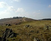
; its elevation is generally 600 ft (180 m) and upwards, the area exceeding this height being about 6100 acres (24.7 km²). The highest point, Bardon Hill
Bardon Hill
Bardon Hill is a hill in the civil parish of Bardon near Coalville, Leicestershire. It the highest point in Leicestershire and the National Forest, above sea level. The hill has two very distinct faces – one half preserved as a site of special scientific interest , the other removed by Bardon Hill...
, is 912 ft (278 m). On its western flank lies an abandoned coal
Coal
Coal is a combustible black or brownish-black sedimentary rock usually occurring in rock strata in layers or veins called coal beds or coal seams. The harder forms, such as anthracite coal, can be regarded as metamorphic rock because of later exposure to elevated temperature and pressure...
field, with Coalville
Coalville
Coalville is a town in North West Leicestershire, England, with a population estimated in 2003 to be almost 33,000. It is situated on the A511 trunk road between Leicester and Burton upon Trent, close to junction 22 of the M1 motorway where the A511 meets the A50 between Ashby-de-la-Zouch and...
and other former mining villages, now being regenerated and replanted as part of the National Forest
National Forest, England
The National Forest is one of England’s most ambitious environmental projects. Across parts of Leicestershire, Derbyshire and Staffordshire, are being transformed, blending ancient woodland with new planting to create a new national forest...
. The M1 motorway
M1 motorway
The M1 is a north–south motorway in England primarily connecting London to Leeds, where it joins the A1 near Aberford. While the M1 is considered to be the first inter-urban motorway to be completed in the United Kingdom, the first road to be built to motorway standard in the country was the...
, between junctions 22 and 23, cuts through Charnwood Forest.
The hard stone of Charnwood Forest has been quarried for centuries, and was a source of whetstone
Sharpening stone
Sharpening stones, water stones or whetstones are used to grind and hone the edges of steel tools and implements. Examples of items that may be sharpened with a sharpening stone include scissors, scythes, knives, razors and tools such as chisels, hand scrapers and plane blades...
s and quern-stone
Quern-stone
Quern-stones are stone tools for hand grinding a wide variety of materials. They were used in pairs. The lower, stationary, stone is called a quern, whilst the upper, mobile, stone is called a handstone...
s. The granite
Granite
Granite is a common and widely occurring type of intrusive, felsic, igneous rock. Granite usually has a medium- to coarse-grained texture. Occasionally some individual crystals are larger than the groundmass, in which case the texture is known as porphyritic. A granitic rock with a porphyritic...
quarries at Bardon Hill
Bardon Hill
Bardon Hill is a hill in the civil parish of Bardon near Coalville, Leicestershire. It the highest point in Leicestershire and the National Forest, above sea level. The hill has two very distinct faces – one half preserved as a site of special scientific interest , the other removed by Bardon Hill...
, Buddon Hill, and Whitwick
Whitwick
Whitwick is a village in Leicestershire, England and is an ancient parish which formerly included the equally historic villages of Thringstone and Swannington. It was an important manor in the Middle Ages, which once included Bardon and Markfield, parts of Hugglescote, Donington le Heath, Ratby,...
are of national importance and supply crushed aggregate, much by train, to a wide area of southern Britain.
The Forest is an important recreational area with woodland
Woodland
Ecologically, a woodland is a low-density forest forming open habitats with plenty of sunlight and limited shade. Woodlands may support an understory of shrubs and herbaceous plants including grasses. Woodland may form a transition to shrubland under drier conditions or during early stages of...
walks, noted for their displays of bluebells
Common Bluebell
Hyacinthoides non-scripta, commonly known as the common bluebell, is a spring-flowering bulbous perennial plant. -Taxonomy:...
in the early spring, rock climbing
Rock climbing
Rock climbing also lightly called 'The Gravity Game', is a sport in which participants climb up, down or across natural rock formations or artificial rock walls. The goal is to reach the summit of a formation or the endpoint of a pre-defined route without falling...
, and hillwalking
Hillwalking
In the British Isles, the terms hillwalking or fellwalking are commonly used to describe the recreational outdoor activity of walking on hills and mountains, often with the intention of visiting their summits...
. Popular places with public access include Bardon Hill
Bardon Hill
Bardon Hill is a hill in the civil parish of Bardon near Coalville, Leicestershire. It the highest point in Leicestershire and the National Forest, above sea level. The hill has two very distinct faces – one half preserved as a site of special scientific interest , the other removed by Bardon Hill...
, Beacon Hill
Beacon Hill, Leicestershire
Beacon Hill, near Loughborough, in Leicestershire, England, is a popular country park. It is one of several beacon hills in the United Kingdom.The park consists of of grassland and woodland and offers recreational walking, and some short climbs...
, Bradgate Park
Bradgate Park
Bradgate Park is a public park in Charnwood Forest, in Leicestershire, England, just northwest of Leicester. It covers 850 acres . The park lies between the villages of Newtown Linford, Anstey, Cropston, Woodhouse Eaves and Swithland. The River Lin runs through the park, flowing into Cropston...
, Swithland Wood
Swithland Wood
Swithland Wood is a public woodland in Charnwood Forest, in Leicestershire. Although close to the village of Swithland, it is almost entirely within the parish of Newtown Linford. It is just north of Bradgate Park and also near Woodhouse Eaves and Cropston...
, and the Outwoods.
Extent
The area of hills and open land known as Charnwood Forest has no jurisdictional boundary. (The Borough of CharnwoodCharnwood (borough)
Charnwood is a borough of northern Leicestershire, England. It is named after Charnwood Forest, which it contains. Loughborough is the largest town in the district and serves as the borough's administrative and commercial centre.-History:...
covers roughly two thirds of Charnwood Forest, and the eastern half of the Borough is not part of the Forest). Furthermore, despite its name, Charnwood was never a Royal Forest
Royal forest
A royal forest is an area of land with different meanings in England, Wales and Scotland; the term forest does not mean forest as it is understood today, as an area of densely wooded land...
, and was never subject to Forest Law. So although it is an ancient and well established locality, it has only recently been officially defined, by the Natural England
Natural England
Natural England is the non-departmental public body of the UK government responsible for ensuring that England's natural environment, including its land, flora and fauna, freshwater and marine environments, geology and soils, are protected and improved...
National Character Area (NCA) process, which takes a somewhat wider definition than many previous attempts to define the area.
Geology
Many of the craggy rocks of Charnwood Forest are of volcanic origin and are very old, dating back through 600 million years to PrecambrianPrecambrian
The Precambrian is the name which describes the large span of time in Earth's history before the current Phanerozoic Eon, and is a Supereon divided into several eons of the geologic time scale...
times. It was the site of the first ever recorded discovery of Charnia
Charnia
Charnia is the genus name given to a frond-like Ediacaran lifeform with segmented ridges branching alternately to the right and left from a zig-zag medial suture. The genus Charnia was named after Charnwood Forest in Leicestershire, England, where the first fossilised specimen was found.- Diversity...
masoni, the earliest known large, complex fossilised species on record. It was discovered in 1957 by a local schoolboy named Roger Mason (thus masoni) who, with friends, was exploring a quarry near the Charnwood village of Woodhouse Eaves
Woodhouse Eaves
Woodhouse Eaves is a village located on the side of Beacon Hill, in the Charnwood Forest area of Leicestershire, England.It is a sizeable rural village, having several pubs and a few shops...
. The rocks of Charnwood Forest remain the only place in Western Europe where these Precambrian fossil
Fossil
Fossils are the preserved remains or traces of animals , plants, and other organisms from the remote past...
s have been found.. Along the western edge of Charnwood Forest the rocks are mainly Precambrian igneous Diorite
Diorite
Diorite is a grey to dark grey intermediate intrusive igneous rock composed principally of plagioclase feldspar , biotite, hornblende, and/or pyroxene. It may contain small amounts of quartz, microcline and olivine. Zircon, apatite, sphene, magnetite, ilmenite and sulfides occur as accessory...
s. These formed from molten lava deep within the sedimentary rocks, cooling slowly to produce hard, blocky rock with large crystals. This is extensively quarried for roadstone around Groby
Groby
Groby is a large English village in the county of Leicestershire, to the north west of the city of Leicester. The population at the time of the 2001 census was 7,301.-Description:...
, Markfield
Markfield
Markfield is a commuter village sitting within both the National Forest and Charnwood Forest and in the Hinckley and Bosworth district of Leicestershire, England. The settlement dates back to at least the time of the Norman conquest and is mentioned in the Domesday Book under the name...
and Whitwick
Whitwick
Whitwick is a village in Leicestershire, England and is an ancient parish which formerly included the equally historic villages of Thringstone and Swannington. It was an important manor in the Middle Ages, which once included Bardon and Markfield, parts of Hugglescote, Donington le Heath, Ratby,...
, and is known as granite (formerly also called Markfieldite).. The central area of the forest has older rocks still. These are sedimentary and are very variable in character, They were formed by material from volcanoes, settling in deep water, and it is in these beds that the fossils are found. Uplifting, tilting and erosion have produced the distinctive jagged outcrops found across the highest parts of Charnwood. On the eastern side, a much more recent series of rocks are found. Again igneous Diorites, that formed deep underground, but these are Ordovician
Ordovician
The Ordovician is a geologic period and system, the second of six of the Paleozoic Era, and covers the time between 488.3±1.7 to 443.7±1.5 million years ago . It follows the Cambrian Period and is followed by the Silurian Period...
, from a mere 450 million years ago. These are extensively quarried in the areas near Mountsorrel
Mountsorrel
Mountsorrel is a village in Leicestershire on the River Soar, just south of Loughborough with a population in 2001 of 6,662 inhabitants.-Geography:...
.
History
The earliest form of the name Charnwood is probably derived from cerne woda, from the Celtic carn, meaning cairnCairn
Cairn is a term used mainly in the English-speaking world for a man-made pile of stones. It comes from the or . Cairns are found all over the world in uplands, on moorland, on mountaintops, near waterways and on sea cliffs, and also in barren desert and tundra areas...
, and the Old English wudu, meaning wood. Some sources give cwern as the derivation, meaning hand mill
Quern-stone
Quern-stones are stone tools for hand grinding a wide variety of materials. They were used in pairs. The lower, stationary, stone is called a quern, whilst the upper, mobile, stone is called a handstone...
, the stone for which was quarried in the area.
Archeological evidence has shown that the area was inhabited as far back as the Neolithic period, approximately 4,000-2,000BC. Beacon Hill is the site of an Bronze Age hill fort, dating from between 600BC-AD43. This forms one of the last surviving visible features in the landscape known to the Coritani, the tribe who occupied most of the East Midlands area at the time of the Roman Conquest.
According to Domesday Book
Domesday Book
Domesday Book , now held at The National Archives, Kew, Richmond upon Thames in South West London, is the record of the great survey of much of England and parts of Wales completed in 1086...
, there was only one settlement in Charnwood Forest in 1086, at Charley
Charley, Leicestershire
Charley is a civil parish located in the North West Leicestershire district of Leicestershire, England. According to the 2001 census, it had a population of 203. It is set within the Charnwood Forest....
whose name would appear to come from the same root, with the suffix -ley denoting open land, rather than forest.
In the 200 years after the Norman Conquest, newly created settlements took major areas of land out of the Forest for use in agriculture. Quorn
Quorn, Leicestershire
Quorn is a village in Leicestershire, England, situated next to the university town of Loughborough. Quorn's name was shortened from Quorndon in 1889, to avoid postal difficulties owing to its similarity to the name of another village, Quarndon, a few miles away. Its original name is said to derive...
was established between 1086 and 1153, and all the land up to Woodhouse
Woodhouse, Leicestershire
Woodhouse, often known to locals as Old Woodhouse, is a small village in the heart of Charnwood, England. Located between the larger Woodhouse Eaves and Quorn villages, this picturesque village, with a mixture of small cottages and large modern houses, is one of the most expensive villages in the...
had been reclaimed from the forest by 1228.
There were comparatively few major changes in land use in the post Medieval period, until the demand for timber and charcoal for the early Industrial Revolution
Industrial Revolution
The Industrial Revolution was a period from the 18th to the 19th century where major changes in agriculture, manufacturing, mining, transportation, and technology had a profound effect on the social, economic and cultural conditions of the times...
contributed to a further loss of woodland. By the end of the 18th century, most of the woodland had disappeared leaving large areas of moorland and pasture.
The area was the inspiration for "Charnwood Poems", a collection of poems by author, playwright and poet Albert Francis Cross
Albert Francis Cross
Albert Francis Cross wrote under the pen name of A. F. Cross. He was a noted poet, playwright, journalist and author and the founder of several theatres and newspapers in the English Midlands area....
(1863–1940).
Wildlife and Geological Sites
Charnwood Forest covers approx 173 km² (66.8 sq mi) of LeicestershireLeicestershire
Leicestershire is a landlocked county in the English Midlands. It takes its name from the heavily populated City of Leicester, traditionally its administrative centre, although the City of Leicester unitary authority is today administered separately from the rest of Leicestershire...
, split over three local government districts: Charnwood Borough
Charnwood (borough)
Charnwood is a borough of northern Leicestershire, England. It is named after Charnwood Forest, which it contains. Loughborough is the largest town in the district and serves as the borough's administrative and commercial centre.-History:...
, North West Leicestershire
North West Leicestershire
North West Leicestershire is a local government district in Leicestershire, England. Its main towns are Ashby-de-la-Zouch and Coalville.The district contains East Midlands Airport, which operates flights to the rest of Britain and to various places in Europe...
District, and Hinckley and Bosworth
Hinckley and Bosworth
Hinckley and Bosworth is a local government district with borough status in south-western Leicestershire, England, administered by Hinckley and Bosworth Borough Council. Its only towns are Hinckley, Earl Shilton and Market Bosworth...
District. It includes a National Nature Reserve
National Nature Reserves in England
National Nature Reserves in England are managed by Natural England and are key places for wildlife and natural features in England. They were established to protect the most important areas of habitat and of geological formations...
(NNR), 19 SSSIs (Some subdivided in the list of sites below), 4 GCR
Geological Conservation Review
The Geological Conservation Review is produced by the UK's Joint Nature Conservation Committee and is designed to identify those sites of national and international importance needed to show all the key scientific elements of the geological and geomorphological features of Britain...
sites of International geological importance plus a further 6 GCR
Geological Conservation Review
The Geological Conservation Review is produced by the UK's Joint Nature Conservation Committee and is designed to identify those sites of national and international importance needed to show all the key scientific elements of the geological and geomorphological features of Britain...
sites, 13 Regionally Important Geological Sites (RIGS), 5 Local Nature Reserve
Local Nature Reserve
Local nature reserve or LNR is a designation for nature reserves in the United Kingdom. The designation has its origin in the recommendations of the Wild Life Conservation Special Committee which established the framework for nature conservation in the United Kingdom and suggested a national suite...
s (LNRs), 7 Leicestershire and Rutland Wildlife Trust
Leicestershire and Rutland Wildlife Trust
The Leicestershire and Rutland Wildlife Trust is a wildlife trust covering the counties of Leicestershire and Rutland, England. Founded in 1956, the trust now has 9,000 members helping care for over 30 nature reserves covering more than across the region...
(LRWT) nature reserves, and 1 Woodland Trust
Woodland Trust
The Woodland Trust is a conservation charity in the United Kingdom concerned with the protection and sympathetic management of native woodland heritage.-History:...
woodland. 17 sites have open access to the public. Footpaths and bridleways give views and limited access to the other sites listed, and to the rest of the Charnwood Forest landscape. Over half of Charnwood Forest is included within the National Forest. It is also crossed by two waymarked long distance walking routes – the Leicestershire Round and the Ivanhoe Way. The 45 sites listed here include sites with statutory wildlife or geological designations, plus other sites included in published lists of notable sites. On both the map and table, green denotes a site open to the public, amber denotes a site with limited access, or restricted by permit or membership. Red denotes a site with no public access except by special arrangement with the owners.
| Map No. | Site Name | Status | Access | Grid Ref. | Area (ha) | Habitat | Ownership and details |
|---|---|---|---|---|---|---|---|
| 1 | Breedon Cloud Wood and Quarry | SSSI(B&G) & RIGS | Restricted | SK415214 52.7886°N 1.3860°W | 63 | Ancient woodland and limestone quarry | Breedon Cloud Wood is owned by LRWT. Permit needed. Cloud Hill Quarry is owned by Ennstone Breedon Ltd. |
| 2 | Shepshed Cutting | SSSI(G) | Partial | SK46218652.7630°N 1.3168°W | 6.1 | Old Quarry with Galena of a type unknown elsewhere in the world. | The quarry is crossed by a disused railway cutting of the Charnwood Forest Railway Charnwood Forest Railway The Charnwood Forest Railway was a branch line in Leicestershire constructed by the Charnwood Forest Company between 1881 and 1883. The branch line ran from Coalville to the town of Loughborough.... which is now a path and cycleway, and of the short-lived Charnwood Forest Canal. |
| 3 | Morley Quarry, Shepshed | LNR, GCR & RIGS | Open | SK476179 52.7566 °N 1.2961°W | 3 | Disused quarry | Charnwood Borough Council. Car Park off Iveshead Road. Cliff faces show the oldest of Charnwood's Precambrian Precambrian The Precambrian is the name which describes the large span of time in Earth's history before the current Phanerozoic Eon, and is a Supereon divided into several eons of the geologic time scale... rocks and the Triassic Triassic The Triassic is a geologic period and system that extends from about 250 to 200 Mya . As the first period of the Mesozoic Era, the Triassic follows the Permian and is followed by the Jurassic. Both the start and end of the Triassic are marked by major extinction events... unconformity. |
| 4 | Newhurst Quarry, Shepshed | SSSI(G), GCR & RIGS | None | SK485179 52.7565 °N 1.2828°W | 9 | Quarry currently being used for waste disposal | Landfill site managed by Biffa. GCR listing for Mineralogy significance. |
| 5 | Holywell Wood | Woodland | Partial | SK507183 52.7599 °N 1.2501°W | Woodland | Private. Public footpath runs along its northern edge from Snells Nook Lane. | |
| 6 | Longcliffe Quarry, Shepshed | RIGS | None | SK492170 52.7844 °N 1.2726°W | Quarry site | Midland Quarry Products: working quarry. | |
| 7 | Ives Head | GCR(I) & RIGS | Partial | SK478170 52.7485 °N 1.2933 °W | Old quarry and craggy hilltop | Privately owned disused quarry. A public bridleway passes 500m south of the summit (201m). | |
| 8 | Blackbrook Reservoir Blackbrook Reservoir Blackbrook Reservoir is a large body of water near Shepshed, Leicestershire, in England. The reservoir was constructed in 1796 in order to feed the Charnwood Forest Canal, which has long since vanished. The first dam constructed was an earthworks one, and this failed on February 20 of 1799... |
SSSI(B&G) & GCR | Partial | SK457175 52.7532 °N 1.3243°W | 38.6 | Open water, wooded banks, wetlands | Severn Trent Water. Access to the viaduct and wooded slopes via One Barrow Lane. |
| 9 | Grace Dieu And High Sharpley | SSSI (B&G) | Partial | SK437170 52.7489 °N 1.3540°W | 89 | Heathland and Carbonifierous limestone outcrops | Private owners. Adjoins National Forest access land and Grace Dieu Priory site. |
| 10 | Cademan Wood | Woodland | Partial | SK438170 52.7489 °N 1.3526°W | Mixed woodland with rocky outcrops | De Lisle family. Public footpaths and informal open access. Spectacular outcrops that formed very close to a Precambrian Precambrian The Precambrian is the name which describes the large span of time in Earth's history before the current Phanerozoic Eon, and is a Supereon divided into several eons of the geologic time scale... volcano. |
|
| 11 | Snibston Snibston Snibston is a former coal mining village in Coalville, north west Leicestershire, in the English Midlands, now part of the civil parish of Ravenstone with Snibston. Its 13th century church of St Mary is the smallest church still in use for regular worship in England... Country Park and Grange Nature Reserve |
LNR | Open | SK416142 52.7238 °N 1.3855°W | 40 | Woodland, meadow, marsh and ponds | Leicestershire County Council. |
| 12 | Nature Alive! Coalville | LNR | Open | SK421151 52.7319 °N 1.3780°W | 6 | Regenerated scrub and wetland on former industrial land | North West Leicestershire District Council. Valuable site for dragonflies. |
| 13 | Whitwick Quarry | RIGS | None | SK448159 52.7389 °N 1.3379°W | Quarry site | Midland Quarry Products | |
| 14 | Mount St Bernard Abbey | Abbey | Partial | SK457162 52.7415 °N 1.3245°W | Cistercian Abbey | Visitors to the Abbey and grounds are made welcome. The crags around The Knoll show steeply dipping Charnian tuff Tuff Tuff is a type of rock consisting of consolidated volcanic ash ejected from vents during a volcanic eruption. Tuff is sometimes called tufa, particularly when used as construction material, although tufa also refers to a quite different rock. Rock that contains greater than 50% tuff is considered... s. |
|
| 15 | Charnwood Lodge | NNR, SSSI(B&G) & GCR | Restricted | SK466155 52.7351 °N 1.3113°W | 193.5 | Acid and heath grasslands with some mixed woodland | LRWT, permit needed for parts. Timberwood Hill and Warren Hills are accessible under the right to roam. |
| 16 | Jubilee Wood Jubilee Wood Jubilee Wood is on the Woodhouse Eaves to Nanpantan road in North West Leicestershire.The site comprises of mixed woodland with rocky outcrops and was presented to Leicestershire County Council in 1977 to commemorate the Silver Jubilee of Elizabeth II. It is designated a Site of Special Scientific... , Woodhouse Lane |
Public woodland | Open | SK510165 52.7437°N 1.2460°W | 10 | Mixed woodland and rocky outcrops | Leicestershire County Council. |
| 17 | Loughborough Outwoods, Woodhouse Lane | SSSI(B&G) GCR (I) | Open | SK515160 52.7392°N 1.2387°W | 44.6 | Mixed woodland and rocky outcrops | Charnwood Borough Council. Free car park. |
| 18 | Woodbrook and Deans Wood | Stream and woodland | Partial | SK505158 52.7375°N 1.2535°W | Charnwood stream and woodland | Permissive path from Jubilee wood to Deans Lane. | |
| 19 | Charley Woods | Nature reserve | Open | SK476148 52.7288 °N 1.2966°W | 28.8 | Oak woodland | LRWT, open to the public. |
| 20 | Bardon Hill Bardon Hill Bardon Hill is a hill in the civil parish of Bardon near Coalville, Leicestershire. It the highest point in Leicestershire and the National Forest, above sea level. The hill has two very distinct faces – one half preserved as a site of special scientific interest , the other removed by Bardon Hill... Quarry |
SSSI(G) GCR and RIGS | None | SK459133 52.7154 °N 1.3220°W | 79 | Quarry. Precambrian Igneous Rocks | Aggregate Industries. |
| 21 | Bardon Hill Bardon Hill Bardon Hill is a hill in the civil parish of Bardon near Coalville, Leicestershire. It the highest point in Leicestershire and the National Forest, above sea level. The hill has two very distinct faces – one half preserved as a site of special scientific interest , the other removed by Bardon Hill... |
SSSI(B) | Partial | SK461132 52.7145 °N 1.3190°W | 13 | High moorland, highest point in Leicestershire (278m) | Private land. Access to the summit, via public footpaths with expansive views. |
| 22 | Beacon Hill Beacon Hill, Leicestershire Beacon Hill, near Loughborough, in Leicestershire, England, is a popular country park. It is one of several beacon hills in the United Kingdom.The park consists of of grassland and woodland and offers recreational walking, and some short climbs... , Woodhouse Eaves |
SSSI(B&G) GCR & Ancient Monument | Open | SK513146 52.7266 °N 1.2418°W | 135 | Heathland, rocks, woodland hillfort | Leicestershire County Council. |
| 23 | Broombriggs Farm and Windmill Hill | Farm Trail | Open | SK523144 52.7247 °N 1.2271°W | 55 | Farmland and heath | Leicestershire County Council. Pay car park. |
| 24 | Buddon Brook | Stream | Partial | SK556156 52.7352 °N 1.1780°W | Stream habitat | Private farmland. A public footpath runs beside the stream. | |
| 25 | Buddon Wood | SSSI(B&G) and RIGS | None | SK558152 52.7316 °N 1.1751°W | 89 | Ancient Oak woodland, now mostly quarried away, | Private – including Lafarge Aggregates. |
| 26 | Main Quarry, Mountsorrel | SSSI(G) & GCR | None | SK577148 52.7278 °N 1.1470°W | 14 | Quarry site | Lafarge Aggregates. Largest manmade hole in Europe.School visits are possible. |
| 27 | Swithland Reservoir Swithland Reservoir Swithland Reservoir is a reservoir in the English county of Leicestershire. It is north-east of the village of Swithland from which it takes its name, north-west of Rothley and approximately 133 metres south-west of Mountsorrel Quarry. The dam is at the north end and is crossed by Kinchley Lane... and Brazil Island |
SSSI (B&G) and RIGS | Partial | SK560142 52.72260°N 1.1723°W | 98 | Open water, wooded banks | Severn Trent Water. Limited road and footpath access. Excellent views from Great Central Railway, which crosses the reservoir via Brazil Island. |
| 28 | The Brand, Swithland | SSSI(B&G) & GCR | None | SK536133 52.7147 °N 1.2080°W | 18 | Oak woodland, grassy heath and old slate quarries | Private (Martin family). Occasional open days. |
| 29 | Roecliffe Manor Lawns | SSSI(B) | None | SK531125 52.7076 °N 1.2155°W | 1.2 | Species rich grassland with rare fungi | Leonard Cheshire Care Home. |
| 30 | Swithland Wood Swithland Wood Swithland Wood is a public woodland in Charnwood Forest, in Leicestershire. Although close to the village of Swithland, it is almost entirely within the parish of Newtown Linford. It is just north of Bradgate Park and also near Woodhouse Eaves and Cropston... |
SSSI(B&G) | Open | SK540123 52.7057 °N 1.2022°W | 61 | Ancient Woodland and disused slate quarries | Bradgate Park Trust. Pay car parks. |
| 31 | Benscliffe Wood | SSSI(B) | None | SK514127 52.7095 °N 1.2406°W | 10 | Mixed woodland | Private wood. Particularly rich in lichen species. |
| 32 | Ulverscroft Nature Reserve, Whitcroft's Lane | Nature reserve | Restricted | SK490124 52.7071 °N 1.2762°W | 56 | Mixed woodland, marshy grassland and meadow | NT, managed by LRWT (NT members need LRWT permit). |
| 33 | Rocky Plantation, Nr Markfield | Nature reserve | Restricted | SK493118 52.7016 °N 1.2719°W | 3.4 | Mixed woodland and rocky outcrops | NT, managed by LRWT. Open to Wildlife Trust and National Trust members only. |
| 34 | Lea Meadows, Ulverscroft Lane | SSSI | Open | SK506115 52.6988 °N 1.2527°W | 12 | Meadow | LRWT, open to the public. |
| 35 | Billa Barra Hill | LNR & RIGS | Open | SK468113 52.6974 °N 1.3089°W | 20 | Old quarry, grassland, mature and recent woodland. | Hinckley and Bosworth Borough Council. Open to the public. Car Park on Billa Barra Lane. |
| 36 | New Cliffe Hill Quarry | RIGS | None | SK463108 52.6929 °N 1.3164°W | 243 | Quarry. Precambrian Rocks | Midland Quarry Products: working quarry (A tunnel links this to Cliffe Hill Quarry). |
| 37 | Cliffe Hill Quarry | SSSI(G) GCR (I) and RIGS | None | SK475105 52.6901 °N 1.2987°W | 37 | Quarry. Precambrian Rocks | Midland Quarry Products: working quarry. |
| 38 | Altar Stones, Markfield Markfield Markfield is a commuter village sitting within both the National Forest and Charnwood Forest and in the Hinckley and Bosworth district of Leicestershire, England. The settlement dates back to at least the time of the Norman conquest and is mentioned in the Domesday Book under the name... |
Nature reserve | Open | SK485107 52.6918 °N 1.2839°W | 3.7 | Rough heath grassland with rock outcrops | LRWT, open to the public. |
| 39 | Hill Hole Quarry, Markfield Markfield Markfield is a commuter village sitting within both the National Forest and Charnwood Forest and in the Hinckley and Bosworth district of Leicestershire, England. The settlement dates back to at least the time of the Norman conquest and is mentioned in the Domesday Book under the name... |
Nature reserve and RIGS | Open | SK486102 52.6873°N 1.2825°W | 5.4 | Flooded quarry, rock faces and grassland | Hinckley and Bosworth Borough Council. Open to the public. The old quarry faces show the youngest of the area's Precambrian rocks. |
| 40 | Cropston Reservoir Cropston Reservoir Cropston Reservoir lies in Charnwood Forest in Leicestershire, England. The dam and associated water works are in Cropston, while the bulk of the reservoir is in the neighbouring Newtown Linford parish. It was opened in May 1871 in a corner of Bradgate Park, a large expanse of open land just... |
SSSI(B&G) | None | SK546110 52.6939 °N 1.1936°W | 55 | Open water, wetlands | Severn Trent Water. No access but with good views from Bradgate Park. |
| 41 | Bradgate Park Bradgate Park Bradgate Park is a public park in Charnwood Forest, in Leicestershire, England, just northwest of Leicester. It covers 850 acres . The park lies between the villages of Newtown Linford, Anstey, Cropston, Woodhouse Eaves and Swithland. The River Lin runs through the park, flowing into Cropston... |
SSSI(B&G) GCR(I) | Open | SK530110 52.6917 °N 1.2214°W | 340 | Bracken heath, rocks, river, woodland, ancient oaks | Bradgate Park Trust. Pay car parks. |
| 42 | Sheet Hedges Wood Sheet Hedges Wood Sheet Hedges Wood is approx. north of Groby, in Leicestershire.The site is made up of two areas of woodland and an agricultural field with public access, extending .The woodland block is adjacent to the road includes a car park and access trails.... , Newtown Linford |
SSSI(B) | Open | SK524087 52.6735 °N 1.2265°W | 30 | Mixed woodland | Leicestershire County Council. Free car park near Groby Pool. |
| 43 | Groby Pool | SSSI(B) | Partial | SK523082 52.6690°N 1.2280°W | 28 | Open water, wetlands | Amalgamated Roadstone Corp. One side has good roadside paths and access with a large nearby free car park. |
| 44 | Groby Quarry | RIGS | None | SK525083 52.6699 °N 1.2251°W | Working Quarry | Amalgamated Roadstone Corporation (ARC) | |
| 45 | Martinshaw Wood | Public woodland | Open | SK510072 52.6601 °N 1.2474°W | 102 | Mixed woodland | Woodland Trust. |
Abbreviations used in the table:
National Nature Reserve
National Nature Reserve
For details of National nature reserves in the United Kingdom see:*National Nature Reserves in England*National Nature Reserves in Northern Ireland*National Nature Reserves in Scotland*National Nature Reserves in Wales...
(NNR). Site of Special Scientific Interest
Site of Special Scientific Interest
A Site of Special Scientific Interest is a conservation designation denoting a protected area in the United Kingdom. SSSIs are the basic building block of site-based nature conservation legislation and most other legal nature/geological conservation designations in Great Britain are based upon...
(SSSI) (B=Biological, G=Geological). Geological Conservation Review
Geological Conservation Review
The Geological Conservation Review is produced by the UK's Joint Nature Conservation Committee and is designed to identify those sites of national and international importance needed to show all the key scientific elements of the geological and geomorphological features of Britain...
(GCR)(I=of International importance). Regionally Important Geological Site (RIGS). Leicestershire and Rutland Wildlife Trust
Leicestershire and Rutland Wildlife Trust
The Leicestershire and Rutland Wildlife Trust is a wildlife trust covering the counties of Leicestershire and Rutland, England. Founded in 1956, the trust now has 9,000 members helping care for over 30 nature reserves covering more than across the region...
(LRWT). National Trust (NT). Local Nature Reserve (LNR).