
Transcontinental country
Encyclopedia
This is a list of countries spanning more than one continent, known as transcontinental states. While there are many countries with non-contiguous overseas territories fitting this definition, only a limited number of countries have territory spanning an overland continental boundary:
Listed further below, separately, are countries with distant non-contiguous parts (overseas territories) on separate continents.
The land border between Asia
and Africa
is considered to go along the Isthmus of Suez and the Suez Canal
in Egypt
. The border continues through the Gulf of Suez
, Red Sea
and Gulf of Aden
.
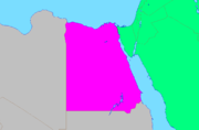
of Egypt
lie entirely on the Asian Sinai Peninsula
and two are transcontinental: Ismailia Governorate is nearly equally divided by the Suez Canal
, and Suez Governorate, which is coterminous with the transcontinental city of Suez
, has a small portion east of the Canal.
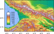
The modern definition of Europe (e.g. National Geographic Society) has the Europe-Asia boundary follow the watershed of the Ural Mountains
to the source of the Ural River
, then follows that river to the Caspian Sea
. The border then follows the Greater Caucasus watershed from the Caspian Sea to the Black Sea. According to this mainstream definition, there are five states with territory across the continental boundary:
A convention in Russian geography draws the continental boundary along the Manych River
to the Caspian, excluding Georgia and Azerbaijan from transcontinental status. A historical convention used in the 19th century followed the lower Volga instead of the Ural river, which would also exclude Kazakhstan from being transcontinental.
watershed. Five districts are entirely within Europe, and the transcontinental Khizi
district is almost equally divided on the two sides of the watershed. Azerbaijan is a member of the Council of Europe.
 The Terek and Sulak
rivers both originate in Georgia and both empty into the Caspian Sea
in Dagestan
; their upper basins in Georgia are north of the Greater Caucasus watershed (the modern day Europe-Asia divide), including northern parts of the Tusheti
and Khevsureti
historical regions and Kazbegi District. A total of 2,650 square kilometers, or 4% of Georgia's territory, is north of the Caucasus Mountains
and thus in Europe.
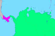
and West Kazakhstan Province
. The capital of the former, Atyrau
, is split by the mouth of the Ural and is a transcontinental city. Almost all of it is in Asia with a small portion in Europe. Two of Atyrau Province's districts are entirely in Europe, three of its districts are entirely in Asia, and its Inderskiy and Makhambetskiy districts are transcontinental. Five of West Kazakhstan's districts and the province's capital city of Oral
are entirely in Europe, five of its districts are entirely in Asia, and its Akzhaikskiy district is transcontinental.
and Ural River
) more often than not. There is also the relatively small 2600 square kilometer Sochi
area of Russia in Asia, bordering Georgia and located south of the main Caucasus
watershed. Orenburg
on the Ural River is a transcontinental city. More detail on the political divisions through which the intercontinental boundary runs can be found here. Russia is a member of the Council of Europe.
's provinces are entirely in Europe while Çanakkale
and Istanbul
are transcontinental provinces. Three of Çanakkale's districts are entirely in Europe and its other nine districts are entirely in Asia
. Nineteen of Istanbul's districts are entirely in Europe and its other twelve districts (forming Anatolia
) are entirely in Asia.
to be North America
's southernmost nation, entirely within both Central America
and North America. A less common alternative view, that the man-made Panama Canal
, the "concrete line" splitting the Isthmus of Panama
, divides the continents would assign Darién Province
to South America, Panamá Province
and Colón Province
to both, and the six other provinces to North America.
North American Caribbean islands belonging to South American countries:
South American Caribbean islands:
These examples have integral parts associated with other continents. France
, Norway
, South Africa
, and the United Kingdom
may also be considered transcontinental by virtue of distant island possessions
associated with a continent other than where the country is based.
and Chile
, consider the Antarctic land they claim to be integral parts of their national territory. Some nations also have sub-Antarctic island possessions north of 60°S latitude and thus recognized by international law under the Antarctic Treaty System
, which holds in abeyance
land claims south of 60°S latitude.
- Asian-European boundary: AzerbaijanAzerbaijanAzerbaijan , officially the Republic of Azerbaijan is the largest country in the Caucasus region of Eurasia. Located at the crossroads of Western Asia and Eastern Europe, it is bounded by the Caspian Sea to the east, Russia to the north, Georgia to the northwest, Armenia to the west, and Iran to...
, GeorgiaGeorgia (country)Georgia is a sovereign state in the Caucasus region of Eurasia. Located at the crossroads of Western Asia and Eastern Europe, it is bounded to the west by the Black Sea, to the north by Russia, to the southwest by Turkey, to the south by Armenia, and to the southeast by Azerbaijan. The capital of...
, KazakhstanKazakhstanKazakhstan , officially the Republic of Kazakhstan, is a transcontinental country in Central Asia and Eastern Europe. Ranked as the ninth largest country in the world, it is also the world's largest landlocked country; its territory of is greater than Western Europe...
, RussiaRussiaRussia or , officially known as both Russia and the Russian Federation , is a country in northern Eurasia. It is a federal semi-presidential republic, comprising 83 federal subjects...
, TurkeyTurkeyTurkey , known officially as the Republic of Turkey , is a Eurasian country located in Western Asia and in East Thrace in Southeastern Europe...
; - African-Asian boundary: EgyptEgyptEgypt , officially the Arab Republic of Egypt, Arabic: , is a country mainly in North Africa, with the Sinai Peninsula forming a land bridge in Southwest Asia. Egypt is thus a transcontinental country, and a major power in Africa, the Mediterranean Basin, the Middle East and the Muslim world...
; and - under a less common, alternative view of the North-to-South American boundary, PanamaPanamaPanama , officially the Republic of Panama , is the southernmost country of Central America. Situated on the isthmus connecting North and South America, it is bordered by Costa Rica to the northwest, Colombia to the southeast, the Caribbean Sea to the north and the Pacific Ocean to the south. The...
.
Listed further below, separately, are countries with distant non-contiguous parts (overseas territories) on separate continents.
Africa and Asia
- See Boundaries between continents for more details about the geographical border between Africa and Asia.
The land border between Asia
Asia
Asia is the world's largest and most populous continent, located primarily in the eastern and northern hemispheres. It covers 8.7% of the Earth's total surface area and with approximately 3.879 billion people, it hosts 60% of the world's current human population...
and Africa
Africa
Africa is the world's second largest and second most populous continent, after Asia. At about 30.2 million km² including adjacent islands, it covers 6% of the Earth's total surface area and 20.4% of the total land area...
is considered to go along the Isthmus of Suez and the Suez Canal
Suez Canal
The Suez Canal , also known by the nickname "The Highway to India", is an artificial sea-level waterway in Egypt, connecting the Mediterranean Sea and the Red Sea. Opened in November 1869 after 10 years of construction work, it allows water transportation between Europe and Asia without navigation...
in Egypt
Egypt
Egypt , officially the Arab Republic of Egypt, Arabic: , is a country mainly in North Africa, with the Sinai Peninsula forming a land bridge in Southwest Asia. Egypt is thus a transcontinental country, and a major power in Africa, the Mediterranean Basin, the Middle East and the Muslim world...
. The border continues through the Gulf of Suez
Gulf of Suez
The northern end of the Red Sea is bifurcated by the Sinai Peninsula, creating the Gulf of Suez in the west and the Gulf of Aqaba to the east. The Gulf of Suez is formed within a relatively young, but now inactive rift basin, the Gulf of Suez Rift, dating back about 28 million years...
, Red Sea
Red Sea
The Red Sea is a seawater inlet of the Indian Ocean, lying between Africa and Asia. The connection to the ocean is in the south through the Bab el Mandeb strait and the Gulf of Aden. In the north, there is the Sinai Peninsula, the Gulf of Aqaba, and the Gulf of Suez...
and Gulf of Aden
Gulf of Aden
The Gulf of Aden is located in the Arabian Sea between Yemen, on the south coast of the Arabian Peninsula, and Somalia in the Horn of Africa. In the northwest, it connects with the Red Sea through the Bab-el-Mandeb strait, which is about 20 miles wide....
.
Egypt
Two of 29 governoratesGovernorates of Egypt
Egypt is divided for administrative purposes into 27 governorates . Egyptian governorates are the top tier of the country's five-tier jurisdiction hierarchy. A governorate is administered by a governor, who is appointed by the President of Egypt and serves at the president's discretion...
of Egypt
Egypt
Egypt , officially the Arab Republic of Egypt, Arabic: , is a country mainly in North Africa, with the Sinai Peninsula forming a land bridge in Southwest Asia. Egypt is thus a transcontinental country, and a major power in Africa, the Mediterranean Basin, the Middle East and the Muslim world...
lie entirely on the Asian Sinai Peninsula
Sinai Peninsula
The Sinai Peninsula or Sinai is a triangular peninsula in Egypt about in area. It is situated between the Mediterranean Sea to the north, and the Red Sea to the south, and is the only part of Egyptian territory located in Asia as opposed to Africa, effectively serving as a land bridge between two...
and two are transcontinental: Ismailia Governorate is nearly equally divided by the Suez Canal
Suez Canal
The Suez Canal , also known by the nickname "The Highway to India", is an artificial sea-level waterway in Egypt, connecting the Mediterranean Sea and the Red Sea. Opened in November 1869 after 10 years of construction work, it allows water transportation between Europe and Asia without navigation...
, and Suez Governorate, which is coterminous with the transcontinental city of Suez
Suez
Suez is a seaport city in north-eastern Egypt, located on the north coast of the Gulf of Suez , near the southern terminus of the Suez Canal, having the same boundaries as Suez governorate. It has three harbors, Adabya, Ain Sokhna and Port Tawfiq, and extensive port facilities...
, has a small portion east of the Canal.
Asia and Europe
- See Borders of the continents for more details about the geographical border between EuropeEuropeEurope is, by convention, one of the world's seven continents. Comprising the westernmost peninsula of Eurasia, Europe is generally 'divided' from Asia to its east by the watershed divides of the Ural and Caucasus Mountains, the Ural River, the Caspian and Black Seas, and the waterways connecting...
and AsiaAsiaAsia is the world's largest and most populous continent, located primarily in the eastern and northern hemispheres. It covers 8.7% of the Earth's total surface area and with approximately 3.879 billion people, it hosts 60% of the world's current human population...
. - See also Geographic criteria for EU membership.
- See also Transcontinental states with territory in Europe.
The modern definition of Europe (e.g. National Geographic Society) has the Europe-Asia boundary follow the watershed of the Ural Mountains
Ural Mountains
The Ural Mountains , or simply the Urals, are a mountain range that runs approximately from north to south through western Russia, from the coast of the Arctic Ocean to the Ural River and northwestern Kazakhstan. Their eastern side is usually considered the natural boundary between Europe and Asia...
to the source of the Ural River
Ural River
The Ural or Jayıq/Zhayyq , known as Yaik before 1775, is a river flowing through Russia and Kazakhstan. It arises in the southern Ural Mountains and ends at the Caspian Sea. Its total length is 1,511 mi making it the third longest river in Europe after the Volga and the Danube...
, then follows that river to the Caspian Sea
Caspian Sea
The Caspian Sea is the largest enclosed body of water on Earth by area, variously classed as the world's largest lake or a full-fledged sea. The sea has a surface area of and a volume of...
. The border then follows the Greater Caucasus watershed from the Caspian Sea to the Black Sea. According to this mainstream definition, there are five states with territory across the continental boundary:
- RussiaRussiaRussia or , officially known as both Russia and the Russian Federation , is a country in northern Eurasia. It is a federal semi-presidential republic, comprising 83 federal subjects...
: with most of its population situated in Europe, has significant territory in Central and Northern Asia (SiberiaSiberiaSiberia is an extensive region constituting almost all of Northern Asia. Comprising the central and eastern portion of the Russian Federation, it was part of the Soviet Union from its beginning, as its predecessor states, the Tsardom of Russia and the Russian Empire, conquered it during the 16th...
in the Russian Far EastRussian Far EastRussian Far East is a term that refers to the Russian part of the Far East, i.e., extreme east parts of Russia, between Lake Baikal in Eastern Siberia and the Pacific Ocean...
. About 75% of Russian population lives in the European part. - TurkeyTurkeyTurkey , known officially as the Republic of Turkey , is a Eurasian country located in Western Asia and in East Thrace in Southeastern Europe...
: mostly situated in Asia MinorAsia MinorAsia Minor is a geographical location at the westernmost protrusion of Asia, also called Anatolia, and corresponds to the western two thirds of the Asian part of Turkey...
, with some territory in Southeastern Europe (Turkish Thrace). About 88% of Turkish population lives in the Asian part. - KazakhstanKazakhstanKazakhstan , officially the Republic of Kazakhstan, is a transcontinental country in Central Asia and Eastern Europe. Ranked as the ninth largest country in the world, it is also the world's largest landlocked country; its territory of is greater than Western Europe...
: mostly situated in Central Asia, with the western parts of two of its provinces west of the Ural River in Europe. About 96% of Kazakh population lives in the Asian part. - AzerbaijanAzerbaijanAzerbaijan , officially the Republic of Azerbaijan is the largest country in the Caucasus region of Eurasia. Located at the crossroads of Western Asia and Eastern Europe, it is bounded by the Caspian Sea to the east, Russia to the north, Georgia to the northwest, Armenia to the west, and Iran to...
: primarily situated in Transcaucasia, with five northeastern districts ("rayons") in European CiscaucasiaCiscaucasiaCiscaucasia , also Ciscaucasus or Fore-Caucasus, is a part of the Caucasus region, and of the North Caucasus in particular.The region is at the northern foothills of the Greater Caucasus range, from the Sea of Azov in the west to the Caspian Sea in the east, separated from the East European Plain...
, north of the Greater Caucasus watershed. About 98% of Azerbaijani population lives in Transcaucasia. - GeorgiaGeorgia (country)Georgia is a sovereign state in the Caucasus region of Eurasia. Located at the crossroads of Western Asia and Eastern Europe, it is bounded to the west by the Black Sea, to the north by Russia, to the southwest by Turkey, to the south by Armenia, and to the southeast by Azerbaijan. The capital of...
: primarily situated in Transcaucasia, with a small area just north of the Greater Caucasus watershed. More than 99% of Georgian population lives in Transcaucasia.
A convention in Russian geography draws the continental boundary along the Manych River
Manych River
Manych is a river in the western and central part of the Kuma-Manych Depression in southern Russia.Tributary to the river Don. The river is 219 km long; its source is Lake Manych-Gudilo in the south-westerm part of the Russian republic of Kalmykia...
to the Caspian, excluding Georgia and Azerbaijan from transcontinental status. A historical convention used in the 19th century followed the lower Volga instead of the Ural river, which would also exclude Kazakhstan from being transcontinental.
Azerbaijan
The northeastern Azerbaijan district borders run mostly along the main CaucasusCaucasus Mountains
The Caucasus Mountains is a mountain system in Eurasia between the Black Sea and the Caspian Sea in the Caucasus region .The Caucasus Mountains includes:* the Greater Caucasus Mountain Range and* the Lesser Caucasus Mountains....
watershed. Five districts are entirely within Europe, and the transcontinental Khizi
Khizi
Khizi is the least-populous rayon of Azerbaijan. Its capital is the village of Xızı. The rayon has a remarkable variety of landscapes. On the flat Caspian coast there are irrigated cattle and chicken-breeding lowlands around Shurabad. West of Giläzi, the Xızı road climbs gently through stripily...
district is almost equally divided on the two sides of the watershed. Azerbaijan is a member of the Council of Europe.
Georgia
Sulak River
The Sulak is a river in Dagestan, Russia. It starts at the confluence of the Avar Koisu and the Andi Koisu rivers. It comes down the Main Sulak Canyon and the Akhetl and Chirkei gorges and the Minor Sulak Canyon...
rivers both originate in Georgia and both empty into the Caspian Sea
Caspian Sea
The Caspian Sea is the largest enclosed body of water on Earth by area, variously classed as the world's largest lake or a full-fledged sea. The sea has a surface area of and a volume of...
in Dagestan
Dagestan
The Republic of Dagestan is a federal subject of Russia, located in the North Caucasus region. Its capital and the largest city is Makhachkala, located at the center of Dagestan on the Caspian Sea...
; their upper basins in Georgia are north of the Greater Caucasus watershed (the modern day Europe-Asia divide), including northern parts of the Tusheti
Tusheti
Tusheti is a historic region in northeast Georgia.-Geography:Located on the northern slopes of the Greater Caucasus Mountains, Tusheti is bordered by the Russian republics of Chechnya and Dagestan to the north and east, respectively; and by the Georgian historic provinces Kakheti and...
and Khevsureti
Khevsureti
Khevsureti/Khevsuria is a historical-ethnographic region in eastern Georgia. They are the branch of Kartvelian people located along both the northern and southern slopes of the Great Caucasus...
historical regions and Kazbegi District. A total of 2,650 square kilometers, or 4% of Georgia's territory, is north of the Caucasus Mountains
Caucasus Mountains
The Caucasus Mountains is a mountain system in Eurasia between the Black Sea and the Caspian Sea in the Caucasus region .The Caucasus Mountains includes:* the Greater Caucasus Mountain Range and* the Lesser Caucasus Mountains....
and thus in Europe.
Kazakhstan
Kazakhstan's provincial borders do not follow the Ural River, although some of its western district borders do so. Two of the provinces are transcontinental, Atyrau ProvinceAtyrau Province
Atyrau Oblast is a province of Kazakhstan. It is situated in the west of the country around the northeast of the Caspian Sea. Its capital is the city of Atyrau, with a population of 142,500 people; the province itself has 480,000 people...
and West Kazakhstan Province
West Kazakhstan Province
West Kazakhstan Province is a province of Kazakhstan. Its capital is Oral , a city of about 200,000 inhabitants.-Geography:...
. The capital of the former, Atyrau
Atyrau
Atyrau , known as Guryev until 1991, is a city in Kazakhstan, and the capital of Atyrau Province. It is located at the mouth of the Ural River, 2700 kilometers west of Almaty and 350 kilometers east of the Russian city of Astrakhan. Other transliterations include Aterau, Atirau, Atyraw, Atyraou,...
, is split by the mouth of the Ural and is a transcontinental city. Almost all of it is in Asia with a small portion in Europe. Two of Atyrau Province's districts are entirely in Europe, three of its districts are entirely in Asia, and its Inderskiy and Makhambetskiy districts are transcontinental. Five of West Kazakhstan's districts and the province's capital city of Oral
Oral, Kazakhstan
Oral , Uralsk in Russian, formerly known as Yaitsk , is a city in northwestern Kazakhstan, at the confluence of the Ural and Chogan Rivers close to the Russian border. As it is located on the western side of the Ural river, it is considered geographically in Europe. It has a population of 350,000...
are entirely in Europe, five of its districts are entirely in Asia, and its Akzhaikskiy district is transcontinental.
Russia
Russian regions' borders follow the continental divide (Ural MountainsUral Mountains
The Ural Mountains , or simply the Urals, are a mountain range that runs approximately from north to south through western Russia, from the coast of the Arctic Ocean to the Ural River and northwestern Kazakhstan. Their eastern side is usually considered the natural boundary between Europe and Asia...
and Ural River
Ural River
The Ural or Jayıq/Zhayyq , known as Yaik before 1775, is a river flowing through Russia and Kazakhstan. It arises in the southern Ural Mountains and ends at the Caspian Sea. Its total length is 1,511 mi making it the third longest river in Europe after the Volga and the Danube...
) more often than not. There is also the relatively small 2600 square kilometer Sochi
Sochi
Sochi is a city in Krasnodar Krai, Russia, situated just north of Russia's border with the de facto independent republic of Abkhazia, on the Black Sea coast. Greater Sochi sprawls for along the shores of the Black Sea near the Caucasus Mountains...
area of Russia in Asia, bordering Georgia and located south of the main Caucasus
Caucasus Mountains
The Caucasus Mountains is a mountain system in Eurasia between the Black Sea and the Caspian Sea in the Caucasus region .The Caucasus Mountains includes:* the Greater Caucasus Mountain Range and* the Lesser Caucasus Mountains....
watershed. Orenburg
Orenburg
Orenburg is a city on the Ural River and the administrative center of Orenburg Oblast, Russia. It lies southeast of Moscow, very close to the border with Kazakhstan. Population: 546,987 ; 549,361 ; Highest point: 154.4 m...
on the Ural River is a transcontinental city. More detail on the political divisions through which the intercontinental boundary runs can be found here. Russia is a member of the Council of Europe.
Turkey
Three of TurkeyTurkey
Turkey , known officially as the Republic of Turkey , is a Eurasian country located in Western Asia and in East Thrace in Southeastern Europe...
's provinces are entirely in Europe while Çanakkale
Çanakkale Province
Çanakkale Province is a province of Turkey, located in the northwestern part of the country. It takes its name from the town of Çanakkale.Like Istanbul, Çanakkale province has a European and an Asian part. The European part is formed by the Gallipoli peninsula, while the Asian part is largely...
and Istanbul
Istanbul Province
Istanbul Province is a province located in north-west Turkey. It has an area of 5,196 km² and a population of 13,255,685. The population was 10,018,735 in 2000. It is surrounded by the provinces of Tekirdağ to the west, Kocaeli to the east, the Black Sea to the northern part and the Sea of...
are transcontinental provinces. Three of Çanakkale's districts are entirely in Europe and its other nine districts are entirely in Asia
Asia
Asia is the world's largest and most populous continent, located primarily in the eastern and northern hemispheres. It covers 8.7% of the Earth's total surface area and with approximately 3.879 billion people, it hosts 60% of the world's current human population...
. Nineteen of Istanbul's districts are entirely in Europe and its other twelve districts (forming Anatolia
Anatolia
Anatolia is a geographic and historical term denoting the westernmost protrusion of Asia, comprising the majority of the Republic of Turkey...
) are entirely in Asia.
North and South America
- See Borders of the continents for more details about the geographical border between the two Americas.
Panama
Most geographers consider PanamaPanama
Panama , officially the Republic of Panama , is the southernmost country of Central America. Situated on the isthmus connecting North and South America, it is bordered by Costa Rica to the northwest, Colombia to the southeast, the Caribbean Sea to the north and the Pacific Ocean to the south. The...
to be North America
North America
North America is a continent wholly within the Northern Hemisphere and almost wholly within the Western Hemisphere. It is also considered a northern subcontinent of the Americas...
's southernmost nation, entirely within both Central America
Central America
Central America is the central geographic region of the Americas. It is the southernmost, isthmian portion of the North American continent, which connects with South America on the southeast. When considered part of the unified continental model, it is considered a subcontinent...
and North America. A less common alternative view, that the man-made Panama Canal
Panama Canal
The Panama Canal is a ship canal in Panama that joins the Atlantic Ocean and the Pacific Ocean and is a key conduit for international maritime trade. Built from 1904 to 1914, the canal has seen annual traffic rise from about 1,000 ships early on to 14,702 vessels measuring a total of 309.6...
, the "concrete line" splitting the Isthmus of Panama
Isthmus of Panama
The Isthmus of Panama, also historically known as the Isthmus of Darien, is the narrow strip of land that lies between the Caribbean Sea and the Pacific Ocean, linking North and South America. It contains the country of Panama and the Panama Canal...
, divides the continents would assign Darién Province
Darién Province
Darién is a province in eastern Panama. It is also the largest province in Panama. It is hot, humid, heavily forested, and sparsely populated, having 48,378 habitants...
to South America, Panamá Province
Panamá Province
Panamá is a major province of the country of Panama, containing the capital city, Panama City. The governor of the province is Mayin Correa, a former mayor of Panama City and elected by President Martinelli after being sworn in on July 1, 2009.-Districts:...
and Colón Province
Colón Province
Colón is a province of Panama. The capital is the city of Colón.This province has traditionally been focused in commerce , but also has natural resources that are being developed as tourist attraction, such as coral reefs and rainforests...
to both, and the six other provinces to North America.
Asia and Europe
- See Borders of the continents for more details about the geographical border between EuropeEuropeEurope is, by convention, one of the world's seven continents. Comprising the westernmost peninsula of Eurasia, Europe is generally 'divided' from Asia to its east by the watershed divides of the Ural and Caucasus Mountains, the Ural River, the Caspian and Black Seas, and the waterways connecting...
and AsiaAsiaAsia is the world's largest and most populous continent, located primarily in the eastern and northern hemispheres. It covers 8.7% of the Earth's total surface area and with approximately 3.879 billion people, it hosts 60% of the world's current human population...
.
- The territory of GreeceGreeceGreece , officially the Hellenic Republic , and historically Hellas or the Republic of Greece in English, is a country in southeastern Europe....
includes a number of islands just off the coast of Asia Minor, such as RhodesRhodesRhodes is an island in Greece, located in the eastern Aegean Sea. It is the largest of the Dodecanese islands in terms of both land area and population, with a population of 117,007, and also the island group's historical capital. Administratively the island forms a separate municipality within...
, SamosSamošSamoš is a village in Serbia. It is situated in the Kovačica municipality, in the South Banat District, Vojvodina province. The village has a Serb ethnic majority and its population numbering 1,247 people .-See also:...
, ChiosChiosChios is the fifth largest of the Greek islands, situated in the Aegean Sea, seven kilometres off the Asia Minor coast. The island is separated from Turkey by the Chios Strait. The island is noted for its strong merchant shipping community, its unique mastic gum and its medieval villages...
and Lesbos.
Europe and North America
- Greenland: GreenlandGreenlandGreenland is an autonomous country within the Kingdom of Denmark, located between the Arctic and Atlantic Oceans, east of the Canadian Arctic Archipelago. Though physiographically a part of the continent of North America, Greenland has been politically and culturally associated with Europe for...
is today a territory of DenmarkDenmarkDenmark is a Scandinavian country in Northern Europe. The countries of Denmark and Greenland, as well as the Faroe Islands, constitute the Kingdom of Denmark . It is the southernmost of the Nordic countries, southwest of Sweden and south of Norway, and bordered to the south by Germany. Denmark...
, fully located on the North American tectonic plate and close to the mainland, and is considered to be geographically part of North America. Although it is politically associated with Europe and internationally represented by a European country (including in the Council of Europe), it is largely autonomous. Historically and ethnically, its native population is of American tradition, although it also shares cultural links with other native peoples bordering the Arctic Sea in Northern Europe and Asia (today in Norway, Sweden, Finland and Russia), as well as in North America (Alaska in the U.S., Northwest Territories and Nunavut in Canada). Greenland was part of the Danish territory and within the territory of the European Union, but voted for a larger autonomy and is now excluded from it.
- Iceland: IcelandIcelandIceland , described as the Republic of Iceland, is a Nordic and European island country in the North Atlantic Ocean, on the Mid-Atlantic Ridge. Iceland also refers to the main island of the country, which contains almost all the population and almost all the land area. The country has a population...
is located on the fracture line splitting the Northern Atlantic OceanAtlantic OceanThe Atlantic Ocean is the second-largest of the world's oceanic divisions. With a total area of about , it covers approximately 20% of the Earth's surface and about 26% of its water surface area...
between the North American plate and the Eurasian plate. Geographically, it is much closer to North America than it is to Europe. Under a pure geological definition, Iceland would qualify as a transcontinental country ; however, ethnically, historically, and culturally, this country, well defined by the borders of its main island which was never split in separate cultural areas, is commonly considered to be European. Iceland is a full member of the Council of EuropeCouncil of EuropeThe Council of Europe is an international organisation promoting co-operation between all countries of Europe in the areas of legal standards, human rights, democratic development, the rule of law and cultural co-operation...
(but still not in the European Union, to which it could qualify).
- Portugal: Continental PortugalContinental PortugalContinental Portugal or Mainland Portugal is the designation of the mainland Portuguese territory, located on Europe's Iberian Peninsula....
is in EuropeEuropeEurope is, by convention, one of the world's seven continents. Comprising the westernmost peninsula of Eurasia, Europe is generally 'divided' from Asia to its east by the watershed divides of the Ural and Caucasus Mountains, the Ural River, the Caspian and Black Seas, and the waterways connecting...
, while the AzoresAzoresThe Archipelago of the Azores is composed of nine volcanic islands situated in the middle of the North Atlantic Ocean, and is located about west from Lisbon and about east from the east coast of North America. The islands, and their economic exclusion zone, form the Autonomous Region of the...
archipelago (also associated with Europe) has two islands (CorvoCorvo IslandCorvo Island , literally the Island of the Crow, is the smallest and the northernmost island of the Azores archipelago and the northernmost in Macaronesia, with a population of approximately 468 inhabitants constituting the smallest single municipality in Azores and in Portugal.-History:A small...
and Flores) that are part of the American plate (which made it a tricontinental country, see Africa and Europe section below).
Europe, North America, South America and Africa
- France: Metropolitan FranceMetropolitan FranceMetropolitan France is the part of France located in Europe. It can also be described as mainland France or as the French mainland and the island of Corsica...
is in EuropeEuropeEurope is, by convention, one of the world's seven continents. Comprising the westernmost peninsula of Eurasia, Europe is generally 'divided' from Asia to its east by the watershed divides of the Ural and Caucasus Mountains, the Ural River, the Caspian and Black Seas, and the waterways connecting...
, while the five Overseas Departments are in other continents. GuadeloupeGuadeloupeGuadeloupe is an archipelago located in the Leeward Islands, in the Lesser Antilles, with a land area of 1,628 square kilometres and a population of 400,000. It is the first overseas region of France, consisting of a single overseas department. As with the other overseas departments, Guadeloupe...
& MartiniqueMartiniqueMartinique is an island in the eastern Caribbean Sea, with a land area of . Like Guadeloupe, it is an overseas region of France, consisting of a single overseas department. To the northwest lies Dominica, to the south St Lucia, and to the southeast Barbados...
are in North America, French GuianaFrench GuianaFrench Guiana is an overseas region of France, consisting of a single overseas department located on the northern Atlantic coast of South America. It has borders with two nations, Brazil to the east and south, and Suriname to the west...
is in South America, and MayotteMayotteMayotte is an overseas department and region of France consisting of a main island, Grande-Terre , a smaller island, Petite-Terre , and several islets around these two. The archipelago is located in the northern Mozambique Channel in the Indian Ocean, namely between northwestern Madagascar and...
and RéunionRéunionRéunion is a French island with a population of about 800,000 located in the Indian Ocean, east of Madagascar, about south west of Mauritius, the nearest island.Administratively, Réunion is one of the overseas departments of France...
are in Africa. These five French Overseas Departments are legally and administratively an integral part of FranceFranceThe French Republic , The French Republic , The French Republic , (commonly known as France , is a unitary semi-presidential republic in Western Europe with several overseas territories and islands located on other continents and in the Indian, Pacific, and Atlantic oceans. Metropolitan France...
. There are other island possessions associated with North America, Africa, Oceania, and Antarctica that are French overseas collectives or part of the French Southern and Antarctic Lands, but these are not integral parts of France.
Africa and Europe
- See Borders of the continents for more details about the geographical border between AfricaAfricaAfrica is the world's second largest and second most populous continent, after Asia. At about 30.2 million km² including adjacent islands, it covers 6% of the Earth's total surface area and 20.4% of the total land area...
and EuropeEuropeEurope is, by convention, one of the world's seven continents. Comprising the westernmost peninsula of Eurasia, Europe is generally 'divided' from Asia to its east by the watershed divides of the Ural and Caucasus Mountains, the Ural River, the Caspian and Black Seas, and the waterways connecting...
.
- Italy: Although mainland ItalyItalyItaly , officially the Italian Republic languages]] under the European Charter for Regional or Minority Languages. In each of these, Italy's official name is as follows:;;;;;;;;), is a unitary parliamentary republic in South-Central Europe. To the north it borders France, Switzerland, Austria and...
, SardiniaSardiniaSardinia is the second-largest island in the Mediterranean Sea . It is an autonomous region of Italy, and the nearest land masses are the French island of Corsica, the Italian Peninsula, Sicily, Tunisia and the Spanish Balearic Islands.The name Sardinia is from the pre-Roman noun *sard[],...
, SicilySicilySicily is a region of Italy, and is the largest island in the Mediterranean Sea. Along with the surrounding minor islands, it constitutes an autonomous region of Italy, the Regione Autonoma Siciliana Sicily has a rich and unique culture, especially with regard to the arts, music, literature,...
, the Aegadian IslandsAegadian IslandsThe Aegadian Islands , are a group of small mountainous islands in the Mediterranean Sea off the northwest coast of Sicily, Italy, near the city of Trapani, with a total area of ....
, UsticaUsticaUstica is the name of a small island, about 9 km across, situated 52 km north of Capo Gallo, Italy in the Tyrrhenian Sea...
, and the Aeolian IslandsAeolian IslandsThe Aeolian Islands or Lipari Islands are a volcanic archipelago in the Tyrrhenian Sea north of Sicily, named after the demigod of the winds Aeolus. The locals residing on the islands are known as Eolians . The Aeolian Islands are a popular tourist destination in the summer, and attract up to...
are associated with EuropeEuropeEurope is, by convention, one of the world's seven continents. Comprising the westernmost peninsula of Eurasia, Europe is generally 'divided' from Asia to its east by the watershed divides of the Ural and Caucasus Mountains, the Ural River, the Caspian and Black Seas, and the waterways connecting...
, the closest land to PantelleriaPantelleriaPantelleria , the ancient Cossyra, is an Italian island in the Strait of Sicily in the Mediterranean Sea, southwest of Sicily and just east of the Tunisian coast. Administratively Pantelleria is a comune belonging to the Sicilian province of Trapani...
and the Pelagie IslandsPelagie IslandsThe Pelagie Islands , from the Greek pélagos - πέλαγος meaning "open sea", are the three small islands of Lampedusa, Linosa, and Lampione, located in the Mediterranean Sea between Malta and Tunisia, south of Sicily. To the northwest lie the island of Pantelleria and the Strait of Sicily...
(LampedusaLampedusaLampedusa is the largest island of the Italian Pelagie Islands in the Mediterranean Sea. The comune of Lampedusa e Linosa is part of the Sicilian province of Agrigento which also includes the smaller islands of Linosa and Lampione. It is the southernmost part of Italy. Tunisia, which is about ...
, LinosaLinosaLinosa is one of the Pelagie Islands in the Sicily Channel of the Mediterranean Sea. It is a frazione of the comune of Lampedusa e Linosa, part of the province of Agrigento, Sicily, Italy. It has a population of 450 inhabitants.-Geography:...
and LampioneLampioneLampione is a small rocky island located in the Mediterranean Sea, which belongs geographically to the Pelagie Islands and administratively to the comune of Lampedusa e Linosa, Province of Agrigento, region of Sicily, Italy...
) is TunisiaTunisiaTunisia , officially the Tunisian RepublicThe long name of Tunisia in other languages used in the country is: , is the northernmost country in Africa. It is a Maghreb country and is bordered by Algeria to the west, Libya to the southeast, and the Mediterranean Sea to the north and east. Its area...
on the African mainland. Nevertheless, Pantelleria and Linosa are considered part of Europe, Lampedusa and Lampione part of Africa. - Malta: MaltaMaltaMalta , officially known as the Republic of Malta , is a Southern European country consisting of an archipelago situated in the centre of the Mediterranean, south of Sicily, east of Tunisia and north of Libya, with Gibraltar to the west and Alexandria to the east.Malta covers just over in...
has been geopolitically European in modern times, but may be considered geographically associated with Africa. More detail may be found here. - Portugal: Continental PortugalContinental PortugalContinental Portugal or Mainland Portugal is the designation of the mainland Portuguese territory, located on Europe's Iberian Peninsula....
is in EuropeEuropeEurope is, by convention, one of the world's seven continents. Comprising the westernmost peninsula of Eurasia, Europe is generally 'divided' from Asia to its east by the watershed divides of the Ural and Caucasus Mountains, the Ural River, the Caspian and Black Seas, and the waterways connecting...
, while the archipelago of MadeiraMadeiraMadeira is a Portuguese archipelago that lies between and , just under 400 km north of Tenerife, Canary Islands, in the north Atlantic Ocean and an outermost region of the European Union...
, an autonomous region of PortugalAutonomous regions of PortugalThe two Autonomous Regions of Portugal are the Azores and Madeira...
(including Porto Santo IslandPorto Santo IslandPorto Santo Island is a Portuguese island northeast of Madeira Island in the North Atlantic Ocean; it is the northernmost and easternmost island of the archipelago of Madeira, located in the Atlantic Ocean west of Europe and Africa.- History :...
, the Desertas IslandsDesertas IslandsThe Desertas Islands are a small Portuguese archipelago, located about 25 km to the southeast of Ponta de São Lourenço, the eastern tip of the island of Madeira, the whole chain located roughly between Madeira and the Canary Islands.-Geography:...
and the Savage IslandsSavage IslandsThe Savage Islands, also referred to as the Salvage Islands or the Selvagens Islands, of Sé. They are designated a Nature Reserve, comprising two areas: one on Selvagem Grande Island and the second on Selvagem Pequena Island.-Geography:...
), is associated with Africa. If we consider that the Azores autonomous region of PortugalAutonomous regions of PortugalThe two Autonomous Regions of Portugal are the Azores and Madeira...
have two islands that are part of North America (see Europe and North America section above), Portugal is a tricontinental country. - Spain: Although its mainland is in EuropeEuropeEurope is, by convention, one of the world's seven continents. Comprising the westernmost peninsula of Eurasia, Europe is generally 'divided' from Asia to its east by the watershed divides of the Ural and Caucasus Mountains, the Ural River, the Caspian and Black Seas, and the waterways connecting...
, SpainSpainSpain , officially the Kingdom of Spain languages]] under the European Charter for Regional or Minority Languages. In each of these, Spain's official name is as follows:;;;;;;), is a country and member state of the European Union located in southwestern Europe on the Iberian Peninsula...
has holdings (the Canary IslandsCanary IslandsThe Canary Islands , also known as the Canaries , is a Spanish archipelago located just off the northwest coast of mainland Africa, 100 km west of the border between Morocco and the Western Sahara. The Canaries are a Spanish autonomous community and an outermost region of the European Union...
in the Atlantic, the cities of CeutaCeutaCeuta is an autonomous city of Spain and an exclave located on the north coast of North Africa surrounded by Morocco. Separated from the Iberian peninsula by the Strait of Gibraltar, Ceuta lies on the border of the Mediterranean Sea and the Atlantic Ocean. Ceuta along with the other Spanish...
and MelillaMelillaMelilla is a autonomous city of Spain and an exclave on the north coast of Morocco. Melilla, along with the Spanish exclave Ceuta, is one of the two Spanish territories located in mainland Africa...
on mainland North Africa and its Plazas de soberaníaPlazas de soberaníaThe plazas de soberanía or sovereign territories, referred to in English as Spanish North Africa or simply Spanish Africa, are the current Spanish territories in continental North Africa bordering Morocco, except the autonomous cities of Ceuta and Melilla.After the Reconquista, forces of the...
close to those cities) that are geographically part of AfricaAfricaAfrica is the world's second largest and second most populous continent, after Asia. At about 30.2 million km² including adjacent islands, it covers 6% of the Earth's total surface area and 20.4% of the total land area...
. Canary Islands, Ceuta and Melilla are three of the 17 Autonomous CommunitiesAutonomous communities of SpainAn autonomous community In other languages of Spain:*Catalan/Valencian .*Galician .*Basque . The second article of the constitution recognizes the rights of "nationalities and regions" to self-government and declares the "indissoluble unity of the Spanish nation".Political power in Spain is...
that form Spain, while the Plazas de Soberanía are under different military status. The African Mediterranean island of Isla de AlboránIsla de AlboránThe Isla de Alborán is a small islet in the Alborán Sea, part of the western Mediterranean, about 50 km north of the Moroccan coast and 90 km south of the province of Almería, Spain. A Spanish possession since 1540, it was taken from the Tunisian pirate Al Borani in the Battle of Alborán. It is...
belongs to the transcontinental city of AlmeríaAlmeríaAlmería is a city in Andalusia, Spain, on the Mediterranean Sea. It is the capital of the province of the same name.-Toponym:Tradition says that the name Almería stems from the Arabic المرية Al-Mariyya: "The Mirror", comparing it to "The Mirror of the Sea"...
and the transcontinental province of AlmeríaAlmería (province)-History:The rich customs and Fiestas of the denizens retain links deep into the past, unto the Moors, the Romans, the Greeks, and the Phoenicians.During the taifa era, it was ruled by the Moor Banu al-Amiri from 1012 to 1038, briefly annexed by Valencia , then given by Zaragoza to the Banu Sumadih...
.
Asia and Africa
- Yemen: Although mainland YemenYemenThe Republic of Yemen , commonly known as Yemen , is a country located in the Middle East, occupying the southwestern to southern end of the Arabian Peninsula. It is bordered by Saudi Arabia to the north, the Red Sea to the west, and Oman to the east....
is in the southern Arabian PeninsulaArabian PeninsulaThe Arabian Peninsula is a land mass situated north-east of Africa. Also known as Arabia or the Arabian subcontinent, it is the world's largest peninsula and covers 3,237,500 km2...
and thus part of AsiaAsiaAsia is the world's largest and most populous continent, located primarily in the eastern and northern hemispheres. It covers 8.7% of the Earth's total surface area and with approximately 3.879 billion people, it hosts 60% of the world's current human population...
, and its Hanish IslandsHanish IslandsThe Hanish Islands are an island group in the Red Sea. Most of them are a part of Yemen, but before 1998–1999 they were claimed by Eritrea as well. After a long trial with an international court under the guidance of Dr...
and PerimPerimPerim is a volcanic island strategically located in the Strait of Mandeb at the southern entrance into the Red Sea, off the southwestern coast of Yemen, at . It has a surface area of 13 square kilometers and rises to an altitude of 65 meters. The island has a natural harbour on its southwestern...
in the Red SeaRed SeaThe Red Sea is a seawater inlet of the Indian Ocean, lying between Africa and Asia. The connection to the ocean is in the south through the Bab el Mandeb strait and the Gulf of Aden. In the north, there is the Sinai Peninsula, the Gulf of Aqaba, and the Gulf of Suez...
are associated with Asia, Yemen controls the archipelagoArchipelagoAn archipelago , sometimes called an island group, is a chain or cluster of islands. The word archipelago is derived from the Greek ἄρχι- – arkhi- and πέλαγος – pélagos through the Italian arcipelago...
of SocotraSocotraSocotra , also spelt Soqotra, is a small archipelago of four islands in the Indian Ocean. The largest island, also called Socotra, is about 95% of the landmass of the archipelago. It lies some east of the Horn of Africa and south of the Arabian Peninsula. The island is very isolated and through...
, which lies east of the horn of SomaliaSomaliaSomalia , officially the Somali Republic and formerly known as the Somali Democratic Republic under Socialist rule, is a country located in the Horn of Africa. Since the outbreak of the Somali Civil War in 1991 there has been no central government control over most of the country's territory...
and is much closer to AfricaAfricaAfrica is the world's second largest and second most populous continent, after Asia. At about 30.2 million km² including adjacent islands, it covers 6% of the Earth's total surface area and 20.4% of the total land area...
than AsiaAsiaAsia is the world's largest and most populous continent, located primarily in the eastern and northern hemispheres. It covers 8.7% of the Earth's total surface area and with approximately 3.879 billion people, it hosts 60% of the world's current human population...
. Socotra and the Hadramawt region constitute the transcontinental Hadramawt Governorate.
Asia and Oceania
- AustraliaAustraliaAustralia , officially the Commonwealth of Australia, is a country in the Southern Hemisphere comprising the mainland of the Australian continent, the island of Tasmania, and numerous smaller islands in the Indian and Pacific Oceans. It is the world's sixth-largest country by total area...
: The Commonwealth of Australia consists of its namesake continent and island possessions associated with Oceania, Asia, and Antarctica. Its Indian Ocean island possessions of Christmas IslandChristmas IslandThe Territory of Christmas Island is a territory of Australia in the Indian Ocean. It is located northwest of the Western Australian city of Perth, south of the Indonesian capital, Jakarta, and ENE of the Cocos Islands....
and the Cocos (Keeling) IslandsCocos (Keeling) IslandsThe Territory of the Cocos Islands, also called Cocos Islands and Keeling Islands, is a territory of Australia, located in the Indian Ocean, southwest of Christmas Island and approximately midway between Australia and Sri Lanka....
are associated with AsiaAsiaAsia is the world's largest and most populous continent, located primarily in the eastern and northern hemispheres. It covers 8.7% of the Earth's total surface area and with approximately 3.879 billion people, it hosts 60% of the world's current human population...
. The majority of Australia's Asian island residents have Asian ancestry and are Muslim or Buddhist.
- JapanJapanJapan is an island nation in East Asia. Located in the Pacific Ocean, it lies to the east of the Sea of Japan, China, North Korea, South Korea and Russia, stretching from the Sea of Okhotsk in the north to the East China Sea and Taiwan in the south...
: All of Japan consists of Asian islands except for the remote Bonin Islands, which are a few islands located in the Pacific, and administratively part of the city of TokyoTokyo, ; officially , is one of the 47 prefectures of Japan. Tokyo is the capital of Japan, the center of the Greater Tokyo Area, and the largest metropolitan area of Japan. It is the seat of the Japanese government and the Imperial Palace, and the home of the Japanese Imperial Family...
and the subdivision of Ogasawara VillageOgasawara, Tokyois a village in Ogasawara Subprefecture, Tokyo, Japan, that governs the Bonin Islands, Volcano Islands and three remote islands .-Geography:...
.
- Papua New GuineaPapua New GuineaPapua New Guinea , officially the Independent State of Papua New Guinea, is a country in Oceania, occupying the eastern half of the island of New Guinea and numerous offshore islands...
: Anthropologically Papua New Guinea is a part of MelanesiaMelanesiaMelanesia is a subregion of Oceania extending from the western end of the Pacific Ocean to the Arafura Sea, and eastward to Fiji. The region comprises most of the islands immediately north and northeast of Australia...
and is sometimes included in the Malay ArchipelagoMalay ArchipelagoThe Malay Archipelago refers to the archipelago between mainland Southeastern Asia and Australia. The name was derived from the anachronistic concept of a Malay race....
. It is an observer in ASEAN and has contemplated full membership.
- PhilippinesPhilippinesThe Philippines , officially known as the Republic of the Philippines , is a country in Southeast Asia in the western Pacific Ocean. To its north across the Luzon Strait lies Taiwan. West across the South China Sea sits Vietnam...
, Malaysia, IndonesiaIndonesiaIndonesia , officially the Republic of Indonesia , is a country in Southeast Asia and Oceania. Indonesia is an archipelago comprising approximately 13,000 islands. It has 33 provinces with over 238 million people, and is the world's fourth most populous country. Indonesia is a republic, with an...
, East TimorEast TimorThe Democratic Republic of Timor-Leste, commonly known as East Timor , is a state in Southeast Asia. It comprises the eastern half of the island of Timor, the nearby islands of Atauro and Jaco, and Oecusse, an exclave on the northwestern side of the island, within Indonesian West Timor...
, BruneiBruneiBrunei , officially the State of Brunei Darussalam or the Nation of Brunei, the Abode of Peace , is a sovereign state located on the north coast of the island of Borneo, in Southeast Asia...
and SingaporeSingaporeSingapore , officially the Republic of Singapore, is a Southeast Asian city-state off the southern tip of the Malay Peninsula, north of the equator. An island country made up of 63 islands, it is separated from Malaysia by the Straits of Johor to its north and from Indonesia's Riau Islands by the...
: The Malay ArchipelagoMalay ArchipelagoThe Malay Archipelago refers to the archipelago between mainland Southeastern Asia and Australia. The name was derived from the anachronistic concept of a Malay race....
lies on the border of OceaniaOceaniaOceania is a region centered on the islands of the tropical Pacific Ocean. Conceptions of what constitutes Oceania range from the coral atolls and volcanic islands of the South Pacific to the entire insular region between Asia and the Americas, including Australasia and the Malay Archipelago...
and AsiaAsiaAsia is the world's largest and most populous continent, located primarily in the eastern and northern hemispheres. It covers 8.7% of the Earth's total surface area and with approximately 3.879 billion people, it hosts 60% of the world's current human population...
. Depending on the interpretation of the border, PhilippinesPhilippinesThe Philippines , officially known as the Republic of the Philippines , is a country in Southeast Asia in the western Pacific Ocean. To its north across the Luzon Strait lies Taiwan. West across the South China Sea sits Vietnam...
, Malaysia and IndonesiaIndonesiaIndonesia , officially the Republic of Indonesia , is a country in Southeast Asia and Oceania. Indonesia is an archipelago comprising approximately 13,000 islands. It has 33 provinces with over 238 million people, and is the world's fourth most populous country. Indonesia is a republic, with an...
can be considered transcontinental countries and East TimorEast TimorThe Democratic Republic of Timor-Leste, commonly known as East Timor , is a state in Southeast Asia. It comprises the eastern half of the island of Timor, the nearby islands of Atauro and Jaco, and Oecusse, an exclave on the northwestern side of the island, within Indonesian West Timor...
, Brunei and SingaporeSingaporeSingapore , officially the Republic of Singapore, is a Southeast Asian city-state off the southern tip of the Malay Peninsula, north of the equator. An island country made up of 63 islands, it is separated from Malaysia by the Straits of Johor to its north and from Indonesia's Riau Islands by the...
can be in either side.
North America, Oceania and Asia
- United States: While the territory of the United StatesUnited StatesThe United States of America is a federal constitutional republic comprising fifty states and a federal district...
lies overwhelmingly in North America, it includes the state of HawaiiHawaiiHawaii is the newest of the 50 U.S. states , and is the only U.S. state made up entirely of islands. It is the northernmost island group in Polynesia, occupying most of an archipelago in the central Pacific Ocean, southwest of the continental United States, southeast of Japan, and northeast of...
in OceaniaOceaniaOceania is a region centered on the islands of the tropical Pacific Ocean. Conceptions of what constitutes Oceania range from the coral atolls and volcanic islands of the South Pacific to the entire insular region between Asia and the Americas, including Australasia and the Malay Archipelago...
, as well as other Oceanian island possessions and Alaskan islands on NE Asia's continental shelf.
North and South America
- Aruba, Bonaire, Curaçao and Trinidad and Tobago: The sea islands division of South America and North America is complicated. All CaribbeanCaribbeanThe Caribbean is a crescent-shaped group of islands more than 2,000 miles long separating the Gulf of Mexico and the Caribbean Sea, to the west and south, from the Atlantic Ocean, to the east and north...
islands are often labeled as North American, but the Dutch dependencies of ArubaArubaAruba is a 33 km-long island of the Lesser Antilles in the southern Caribbean Sea, located 27 km north of the coast of Venezuela and 130 km east of Guajira Peninsula...
and CuraçaoCuraçaoCuraçao is an island in the southern Caribbean Sea, off the Venezuelan coast. The Country of Curaçao , which includes the main island plus the small, uninhabited island of Klein Curaçao , is a constituent country of the Kingdom of the Netherlands...
, the Dutch special municipality of Bonaire and the state of Trinidad and TobagoTrinidad and TobagoTrinidad and Tobago officially the Republic of Trinidad and Tobago is an archipelagic state in the southern Caribbean, lying just off the coast of northeastern Venezuela and south of Grenada in the Lesser Antilles...
lie on the continental shelfContinental shelfThe continental shelf is the extended perimeter of each continent and associated coastal plain. Much of the shelf was exposed during glacial periods, but is now submerged under relatively shallow seas and gulfs, and was similarly submerged during other interglacial periods. The continental margin,...
of South America, and can be considered South American as well. Note that all these islands have closer cultural ties with North America. - Colombia: Mainland ColombiaColombiaColombia, officially the Republic of Colombia , is a unitary constitutional republic comprising thirty-two departments. The country is located in northwestern South America, bordered to the east by Venezuela and Brazil; to the south by Ecuador and Peru; to the north by the Caribbean Sea; to the...
is in northwestern South AmericaSouth AmericaSouth America is a continent situated in the Western Hemisphere, mostly in the Southern Hemisphere, with a relatively small portion in the Northern Hemisphere. The continent is also considered a subcontinent of the Americas. It is bordered on the west by the Pacific Ocean and on the north and east...
and Malpelo IslandMalpelo IslandMalpelo Island is an island located from Colombia's Pacific coast, and approximately from Panama's coast. It has a land area of . It is uninhabited except for a small military post manned by the Colombian Army, which was established in 1986. Visitors need a written permit from the Colombian...
in the Pacific OceanPacific OceanThe Pacific Ocean is the largest of the Earth's oceanic divisions. It extends from the Arctic in the north to the Southern Ocean in the south, bounded by Asia and Australia in the west, and the Americas in the east.At 165.2 million square kilometres in area, this largest division of the World...
is also associated with South America, but the nation also controls the San Andrés and Providencia archipelagoArchipelagoAn archipelago , sometimes called an island group, is a chain or cluster of islands. The word archipelago is derived from the Greek ἄρχι- – arkhi- and πέλαγος – pélagos through the Italian arcipelago...
, 640 kilometres (397.7 mi) WNW of Colombia's Caribbean coast, near the Caribbean coast of NicaraguaNicaraguaNicaragua is the largest country in the Central American American isthmus, bordered by Honduras to the north and Costa Rica to the south. The country is situated between 11 and 14 degrees north of the Equator in the Northern Hemisphere, which places it entirely within the tropics. The Pacific Ocean...
. This archipelago is coterminous with the department of the same name. - Venezuela: Mainland VenezuelaVenezuelaVenezuela , officially called the Bolivarian Republic of Venezuela , is a tropical country on the northern coast of South America. It borders Colombia to the west, Guyana to the east, and Brazil to the south...
is on South AmericaSouth AmericaSouth America is a continent situated in the Western Hemisphere, mostly in the Southern Hemisphere, with a relatively small portion in the Northern Hemisphere. The continent is also considered a subcontinent of the Americas. It is bordered on the west by the Pacific Ocean and on the north and east...
, but Isla AvesIsla AvesIsla de Aves , or Aves Island, is a Caribbean dependency of Venezuela. It has been the subject of numerous territorial disputes between the neighboring independent islands, such as Dominica, and European mother countries of surrounding dependent islands, such as the Netherlands. It lies to the west...
are geographically North American. Isla Aves is one of the Federal dependencies of VenezuelaFederal dependencies of VenezuelaThe Federal Dependencies of Venezuela encompass all of Venezuela's off shore islands in the Caribbean Sea and the Gulf of Venezuela...
under the administration of the transcontinental city of CaracasCaracasCaracas , officially Santiago de León de Caracas, is the capital and largest city of Venezuela; natives or residents are known as Caraquenians in English . It is located in the northern part of the country, following the contours of the narrow Caracas Valley on the Venezuelan coastal mountain range...
.
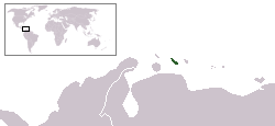
North American Caribbean islands belonging to South American countries:
 |
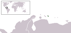
South American Caribbean islands:
 |
 |
 |
 |
Other examples
- ChileChileChile ,officially the Republic of Chile , is a country in South America occupying a long, narrow coastal strip between the Andes mountains to the east and the Pacific Ocean to the west. It borders Peru to the north, Bolivia to the northeast, Argentina to the east, and the Drake Passage in the far...
is mostly on the South American mainland and includes the Oceanian islands of Easter IslandEaster IslandEaster Island is a Polynesian island in the southeastern Pacific Ocean, at the southeasternmost point of the Polynesian triangle. A special territory of Chile that was annexed in 1888, Easter Island is famous for its 887 extant monumental statues, called moai, created by the early Rapanui people...
and Sala y GómezSala y GómezIsla Salas y Gómez, also known as Isla Sala y Gómez, is a small uninhabited Chilean island in the Pacific Ocean. It is the easternmost point in the Polynesian Triangle...
Island. They and the outlying South American Juan Fernández IslandsJuan Fernández IslandsThe Juan Fernández Islands are a sparsely inhabited island group reliant on tourism and fishing in the South Pacific Ocean, situated about off the coast of Chile, and is composed of three main volcanic islands; Robinson Crusoe Island, Alejandro Selkirk Island and Santa Clara Island, the first...
and Desventuradas IslandsDesventuradas Islandsthumb|Map of Desventuradas Islands The Desventuradas Islands, also known as Islas de los Desventurados, is a group of four small islands located off the coast of Chile, northwest of Santiago in the Pacific Ocean...
are part of the Valparaíso RegionValparaíso RegionThe V Valparaíso Region is one of Chile's 15 first order administrative divisions.Valparaíso Region, 2006 With the country's third highest population of 1,539,852 million in 2002 and third smallest area of , the region is Chile's second most densely populated after the Santiago Metropolitan Region...
. - DenmarkDenmarkDenmark is a Scandinavian country in Northern Europe. The countries of Denmark and Greenland, as well as the Faroe Islands, constitute the Kingdom of Denmark . It is the southernmost of the Nordic countries, southwest of Sweden and south of Norway, and bordered to the south by Germany. Denmark...
includes the North American island of GreenlandGreenlandGreenland is an autonomous country within the Kingdom of Denmark, located between the Arctic and Atlantic Oceans, east of the Canadian Arctic Archipelago. Though physiographically a part of the continent of North America, Greenland has been politically and culturally associated with Europe for...
and the Faroe IslandsFaroe IslandsThe Faroe Islands are an island group situated between the Norwegian Sea and the North Atlantic Ocean, approximately halfway between Scotland and Iceland. The Faroe Islands are a self-governing territory within the Kingdom of Denmark, along with Denmark proper and Greenland...
associated with Europe. Greenland was integrated into the Danish Kingdom in 1953 and home ruleHome ruleHome rule is the power of a constituent part of a state to exercise such of the state's powers of governance within its own administrative area that have been devolved to it by the central government....
was granted in 1979. For more information see RigsfællesskabetRigsfællesskabetRigsfællesskabet is a semi-official Danish term for the relations between continental Denmark and its two self-governing insular regions, the Faroe Islands and Greenland, which collectively make up the Kingdom of Denmark.-Legal status:Both the Faroe Islands and Greenland enjoy far-reaching home...
. - The British Turks and Caicos IslandsTurks and Caicos IslandsThe Turks and Caicos Islands are a British Overseas Territory and overseas territory of the European Union consisting of two groups of tropical islands in the Caribbean, the larger Caicos Islands and the smaller Turks Islands, known for tourism and as an offshore financial centre.The Turks and...
, consisting of two groups of tropical islands in the West Indies, the larger Caicos Islands and the smaller Turks Islands - The Kingdom of the NetherlandsKingdom of the NetherlandsThe Kingdom of the Netherlands is a sovereign state and constitutional monarchy with territory in Western Europe and in the Caribbean. The four parts of the Kingdom—Aruba, Curaçao, the Netherlands, and Sint Maarten—are referred to as "countries", and participate on a basis of equality...
includes the constituent countries of ArubaArubaAruba is a 33 km-long island of the Lesser Antilles in the southern Caribbean Sea, located 27 km north of the coast of Venezuela and 130 km east of Guajira Peninsula...
, CuraçaoCuraçaoCuraçao is an island in the southern Caribbean Sea, off the Venezuelan coast. The Country of Curaçao , which includes the main island plus the small, uninhabited island of Klein Curaçao , is a constituent country of the Kingdom of the Netherlands...
, and Sint Maarten. In addition, after the split of the Netherlands AntillesNetherlands AntillesThe Netherlands Antilles , also referred to informally as the Dutch Antilles, was an autonomous Caribbean country within the Kingdom of the Netherlands, consisting of two groups of islands in the Lesser Antilles: Aruba, Bonaire and Curaçao , in Leeward Antilles just off the Venezuelan coast; and Sint...
the Caribbean islands of Bonaire, Sint Eustatius and Saba became special municipalities incorporated into the metropolitan NetherlandsNetherlandsThe Netherlands is a constituent country of the Kingdom of the Netherlands, located mainly in North-West Europe and with several islands in the Caribbean. Mainland Netherlands borders the North Sea to the north and west, Belgium to the south, and Germany to the east, and shares maritime borders...
.
These examples have integral parts associated with other continents. France
France
The French Republic , The French Republic , The French Republic , (commonly known as France , is a unitary semi-presidential republic in Western Europe with several overseas territories and islands located on other continents and in the Indian, Pacific, and Atlantic oceans. Metropolitan France...
, Norway
Norway
Norway , officially the Kingdom of Norway, is a Nordic unitary constitutional monarchy whose territory comprises the western portion of the Scandinavian Peninsula, Jan Mayen, and the Arctic archipelago of Svalbard and Bouvet Island. Norway has a total area of and a population of about 4.9 million...
, South Africa
South Africa
The Republic of South Africa is a country in southern Africa. Located at the southern tip of Africa, it is divided into nine provinces, with of coastline on the Atlantic and Indian oceans...
, and the United Kingdom
United Kingdom
The United Kingdom of Great Britain and Northern IrelandIn the United Kingdom and Dependencies, other languages have been officially recognised as legitimate autochthonous languages under the European Charter for Regional or Minority Languages...
may also be considered transcontinental by virtue of distant island possessions
Borders of the continents
The borders or boundaries separating the various continents of the topography of Earth are a matter of geographical convention.Several slightly different conventions are in use, just as the number of continents is most commonly considered to be seven but may range as low as five, depending on...
associated with a continent other than where the country is based.
Antarctica: claims
A number of nations claim ownership over portions of the continent of Antarctica. Some, including ArgentinaArgentina
Argentina , officially the Argentine Republic , is the second largest country in South America by land area, after Brazil. It is constituted as a federation of 23 provinces and an autonomous city, Buenos Aires...
and Chile
Chile
Chile ,officially the Republic of Chile , is a country in South America occupying a long, narrow coastal strip between the Andes mountains to the east and the Pacific Ocean to the west. It borders Peru to the north, Bolivia to the northeast, Argentina to the east, and the Drake Passage in the far...
, consider the Antarctic land they claim to be integral parts of their national territory. Some nations also have sub-Antarctic island possessions north of 60°S latitude and thus recognized by international law under the Antarctic Treaty System
Antarctic Treaty System
The Antarctic Treaty and related agreements, collectively called the Antarctic Treaty System or ATS, regulate international relations with respect to Antarctica, Earth's only continent without a native human population. For the purposes of the treaty system, Antarctica is defined as all of the land...
, which holds in abeyance
Abeyance
Abeyance is a state of expectancy in respect of property, titles or office, when the right to them is not vested in any one person, but awaits the appearance or determination of the true owner. In law, the term abeyance can only be applied to such future estates as have not yet vested or possibly...
land claims south of 60°S latitude.
See also
- Borders of the continentsBorders of the continentsThe borders or boundaries separating the various continents of the topography of Earth are a matter of geographical convention.Several slightly different conventions are in use, just as the number of continents is most commonly considered to be seven but may range as low as five, depending on...
- Dependent territoryDependent territoryA dependent territory, dependent area or dependency is a territory that does not possess full political independence or sovereignty as a State, and remains politically outside of the controlling state's integral area....
- Historical powersHistorical powersHistorical powers include great powers, nations, or empires in history.The term "Great power" represent the most important world powers. In a modern context, recognised great powers came about first in Europe during the post-Napoleonic era. The formalization of the division between small powers and...
- List of countries by continent
- List of transcontinental empires and countries in history
- ThalassocracyThalassocracyThe term thalassocracy refers to a state with primarily maritime realms—an empire at sea, such as Athens or the Phoenician network of merchant cities...