

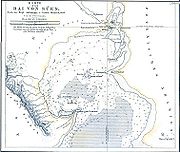
Gulf of Suez
Encyclopedia
Red Sea
The Red Sea is a seawater inlet of the Indian Ocean, lying between Africa and Asia. The connection to the ocean is in the south through the Bab el Mandeb strait and the Gulf of Aden. In the north, there is the Sinai Peninsula, the Gulf of Aqaba, and the Gulf of Suez...
is bifurcated
River bifurcation
River bifurcation occurs when a river flowing in a single stream separates into two or more separate streams which continue downstream. Some rivers form complex networks of distributaries, especially in their deltas...
by the Sinai Peninsula
Sinai Peninsula
The Sinai Peninsula or Sinai is a triangular peninsula in Egypt about in area. It is situated between the Mediterranean Sea to the north, and the Red Sea to the south, and is the only part of Egyptian territory located in Asia as opposed to Africa, effectively serving as a land bridge between two...
, creating the Gulf of Suez ' onMouseout='HidePop("53164")' href="/topics/Arabic_transliteration">transliterated
Arabic transliteration
Different approaches and methods for the romanization of Arabic exist. They vary in the way that they address the inherent problems of rendering written and spoken Arabic in the Latin alphabet; they also use different symbols for Arabic phonemes that do not exist in English or other European...
: Khalīǧ as-Suwais) in the west and the Gulf of Aqaba
Gulf of Aqaba
The Gulf of Aqaba is a large gulf located at the northern tip of the Red Sea. In pre twentieth-century and modern sources it is often named the Gulf of Eilat, as Eilat is its predominant Israeli city ....
to the east. The Gulf of Suez is formed within a relatively young, but now inactive rift basin, the Gulf of Suez Rift
Gulf of Suez Rift
The Gulf of Suez Rift is a continental rift zone that was active between the Late Oligocene and the end of the Miocene . It represented a continuation of the Red Sea Rift until break-up occurred in the middle Miocene, with most of the displacement on the newly developed Red Sea spreading centre...
, dating back about 28 million years. It stretches some 300 kilometres (186.4 mi) north by northwest, terminating at the Egyptian city of Suez
Suez
Suez is a seaport city in north-eastern Egypt, located on the north coast of the Gulf of Suez , near the southern terminus of the Suez Canal, having the same boundaries as Suez governorate. It has three harbors, Adabya, Ain Sokhna and Port Tawfiq, and extensive port facilities...
and the entrance to the Suez Canal
Suez Canal
The Suez Canal , also known by the nickname "The Highway to India", is an artificial sea-level waterway in Egypt, connecting the Mediterranean Sea and the Red Sea. Opened in November 1869 after 10 years of construction work, it allows water transportation between Europe and Asia without navigation...
. Along the mid-line of the Gulf lies the border between the continents of Africa
Africa
Africa is the world's second largest and second most populous continent, after Asia. At about 30.2 million km² including adjacent islands, it covers 6% of the Earth's total surface area and 20.4% of the total land area...
and Asia
Asia
Asia is the world's largest and most populous continent, located primarily in the eastern and northern hemispheres. It covers 8.7% of the Earth's total surface area and with approximately 3.879 billion people, it hosts 60% of the world's current human population...
. The entrance of the Gulf lies atop the mature Gemsa oil and gas field.
Geography
The Gulf of Suez occupies the northwestern arm of the Red SeaRed Sea
The Red Sea is a seawater inlet of the Indian Ocean, lying between Africa and Asia. The connection to the ocean is in the south through the Bab el Mandeb strait and the Gulf of Aden. In the north, there is the Sinai Peninsula, the Gulf of Aqaba, and the Gulf of Suez...
between Africa proper (west) and the Sinai Peninsula (east) of Egypt. It is the third arm of the triple junction
Triple junction
A triple junction is the point where the boundaries of three tectonic plates meet. At the triple junction a boundary will be one of 3 types - a ridge, trench or transform fault - and triple junctions can be described according to the types of plate margin that meet at them...
rift system. The second arm of the triple junction system is the Gulf of Aqaba
Gulf of Aqaba
The Gulf of Aqaba is a large gulf located at the northern tip of the Red Sea. In pre twentieth-century and modern sources it is often named the Gulf of Eilat, as Eilat is its predominant Israeli city ....
.
The length of the gulf, from its mouth at the Strait of Jubal
Jubal
Jubal is a character in the Book of Genesis. "Yubhal" or in Modern Hebrew "Yuval", derived from the Biblical character, is a common male first name in contemporary Israel.Jubal may also refer to:-People:...
to its head at the city of Suez
Suez
Suez is a seaport city in north-eastern Egypt, located on the north coast of the Gulf of Suez , near the southern terminus of the Suez Canal, having the same boundaries as Suez governorate. It has three harbors, Adabya, Ain Sokhna and Port Tawfiq, and extensive port facilities...
, is 195 miles (313.8 km), and it varies in width from 12 to 20 mi (19.3 to 32.2 km).
Extent
The International Hydrographic OrganizationInternational Hydrographic Organization
The International Hydrographic Organization is the inter-governmental organisation representing the hydrographic community. It enjoys observer status at the UN and is the recognised competent authority on hydrographic surveying and nautical charting...
defines the southern limit of the Gulf of Suez as "A line running from Ràs Muhammed (27°43'N) to the South point of Shadwan
Shadwan
Shadwan is a barren rocky island in the mouth of the Gulf of Suez in the northern Red Sea. Situated some 20 miles from Sharm el-Sheikh, the island is in length, and between 3 and 5 km wide. It was formerly also called Shaker Island...
Island (34°02'E) and thence Westward on a parallel (27°27'N) to the coast of Africa
Africa
Africa is the world's second largest and second most populous continent, after Asia. At about 30.2 million km² including adjacent islands, it covers 6% of the Earth's total surface area and 20.4% of the total land area...
".