

Sala y Gómez
Encyclopedia
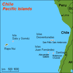
Isla Salas y Gómez, also known as Isla Sala y Gómez, is a small uninhabited Chile
Chile
Chile ,officially the Republic of Chile , is a country in South America occupying a long, narrow coastal strip between the Andes mountains to the east and the Pacific Ocean to the west. It borders Peru to the north, Bolivia to the northeast, Argentina to the east, and the Drake Passage in the far...
an island in the Pacific Ocean
Pacific Ocean
The Pacific Ocean is the largest of the Earth's oceanic divisions. It extends from the Arctic in the north to the Southern Ocean in the south, bounded by Asia and Australia in the west, and the Americas in the east.At 165.2 million square kilometres in area, this largest division of the World...
. It is the easternmost point in the Polynesian Triangle
Polynesian Triangle
The Polynesian Triangle is a region of the Pacific Ocean with three island groups at its corners: Hawaii, Easter Island and New Zealand. It is often used as a simple way to define Polynesia....
. Administratively, it is part of the Easter Island
Easter Island
Easter Island is a Polynesian island in the southeastern Pacific Ocean, at the southeasternmost point of the Polynesian triangle. A special territory of Chile that was annexed in 1888, Easter Island is famous for its 887 extant monumental statues, called moai, created by the early Rapanui people...
Commune in the Easter Island Province of the Valparaíso Region
Valparaíso Region
The V Valparaíso Region is one of Chile's 15 first order administrative divisions.Valparaíso Region, 2006 With the country's third highest population of 1,539,852 million in 2002 and third smallest area of , the region is Chile's second most densely populated after the Santiago Metropolitan Region...
.
Isla Salas y Gómez and its surrounding waters are a Marine Protected Area
Marine Protected Area
Marine Protected Areas, like any protected area, are regions in which human activity has been placed under some restrictions in the interest of conserving the natural environment, it's surrounding waters and the occupant ecosystems, and any cultural or historical resources that may require...
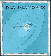
called Parque Marino Sala y Gómez, with a surface area of 150.000 km2.
Geography
Desventuradas Islands
thumb|Map of Desventuradas Islands The Desventuradas Islands, also known as Islas de los Desventurados, is a group of four small islands located off the coast of Chile, northwest of Santiago in the Pacific Ocean...
, and 390 km east-northeast of Easter Island
Easter Island
Easter Island is a Polynesian island in the southeastern Pacific Ocean, at the southeasternmost point of the Polynesian triangle. A special territory of Chile that was annexed in 1888, Easter Island is famous for its 887 extant monumental statues, called moai, created by the early Rapanui people...
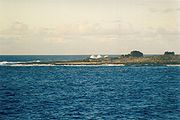
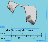
, the closest landmass. Salas y Gómez consists of two rocks
Islet
An islet is a very small island.- Types :As suggested by its origin as islette, an Old French diminutive of "isle", use of the term implies small size, but little attention is given to drawing an upper limit on its applicability....
, a smaller one in the west measuring 4 hectare
Hectare
The hectare is a metric unit of area defined as 10,000 square metres , and primarily used in the measurement of land. In 1795, when the metric system was introduced, the are was defined as being 100 square metres and the hectare was thus 100 ares or 1/100 km2...
in area (270 meters north-south, 200 meters east-west), and a larger one in the east measuring 11 ha (500 meters north-south, 270 meters east-west), which are connected by a narrow isthmus
Isthmus
An isthmus is a narrow strip of land connecting two larger land areas usually with waterforms on either side.Canals are often built through isthmuses where they may be particularly advantageous to create a shortcut for marine transportation...
in the north, averaging approximately 30 meters in width. The total area is approximately 15 hectares (0.15 km²), and the total length northwest-southeast is 770 meters. Its highest point, 30 meters above sea level, is in the south of the eastern rock, less than 30 meters from the shore, above a 10 meter high cliff
Cliff
In geography and geology, a cliff is a significant vertical, or near vertical, rock exposure. Cliffs are formed as erosion landforms due to the processes of erosion and weathering that produce them. Cliffs are common on coasts, in mountainous areas, escarpments and along rivers. Cliffs are usually...
. The highest elevation on the western rock is 26 meters.
The island is showered with saltwater
Seawater
Seawater is water from a sea or ocean. On average, seawater in the world's oceans has a salinity of about 3.5% . This means that every kilogram of seawater has approximately of dissolved salts . The average density of seawater at the ocean surface is 1.025 g/ml...
, and the shoreline is dotted with countless tidepools. Because the shoreline consists primarily of cliffs, landing on the island is difficult in all but the calmest of conditions.
Freshwater
Fresh water is naturally occurring water on the Earth's surface in ice sheets, ice caps, glaciers, bogs, ponds, lakes, rivers and streams, and underground as groundwater in aquifers and underground streams. Fresh water is generally characterized by having low concentrations of dissolved salts and...
on the island, but there is an intermittent rainwater pool in a depression on the eastern rock, which often forms a cache of freshwater 75 meters in diameter. This is essential for the survival of the large population of seabirds.
Even when this area appears dry at the surface, the sand
Sand
Sand is a naturally occurring granular material composed of finely divided rock and mineral particles.The composition of sand is highly variable, depending on the local rock sources and conditions, but the most common constituent of sand in inland continental settings and non-tropical coastal...
is still moist just a few inches below the surface. This flat sandy area is also the only place on the island suitable for landing helicopter
Helicopter
A helicopter is a type of rotorcraft in which lift and thrust are supplied by one or more engine-driven rotors. This allows the helicopter to take off and land vertically, to hover, and to fly forwards, backwards, and laterally...
s.
In 1994, the Chilean Navy
Chilean Navy
-Independence Wars of Chile and Peru :The Chilean Navy dates back to 1817. A year before, following the Battle of Chacabuco, General Bernardo O'Higgins prophetically declared "this victory and another hundred shall be of no significance if we do not gain control of the sea".This led to the...
installed an automated beacon
Beacon
A beacon is an intentionally conspicuous device designed to attract attention to a specific location.Beacons can also be combined with semaphoric or other indicators to provide important information, such as the status of an airport, by the colour and rotational pattern of its airport beacon, or of...
and a tsunami warning system
Tsunami warning system
A Tsunami warning system is used to detect tsunamis in advance and issue warnings to prevent loss of life and damage. It consists of two equally important components: a network of sensors to detect tsunamis and a communications infrastructure to issue timely alarms to permit evacuation of coastal...
. The island has since been declared a nature sanctuary.
Human visitation
Europe
Europe is, by convention, one of the world's seven continents. Comprising the westernmost peninsula of Eurasia, Europe is generally 'divided' from Asia to its east by the watershed divides of the Ural and Caucasus Mountains, the Ural River, the Caspian and Black Seas, and the waterways connecting...
an name of the island. Tradition says that the island was occasionally visited to collect fledglings and eggs. The island was said to have been difficult to land upon, because the gods Make-make
Makemake (mythology)
Makemake in the Rapa Nui mythology of Easter Island, was the creator of humanity, the god of fertility and the chief god of the "Tangata manu" or bird-man cult .He is a frequent subject of the island's Petroglyphs.-In Astronomy:The trans-Neptunian...
and Huau protected the seabirds from those who ate their eggs and offspring. Because of these historical connections to Easter Island, Salas y Gómez can be considered part of Polynesia; if so its location makes it the easternmost landmass of Polynesia. The title is usually awarded to Easter Island, 415 km further west.
The first European to sight the island was José Salas Valdés, a Spanish
Spanish people
The Spanish are citizens of the Kingdom of Spain. Within Spain, there are also a number of vigorous nationalisms and regionalisms, reflecting the country's complex history....
sailor, on 23 August 1793. Between then and 1917, visits are recorded in at least 1805, 1806, 1817, 1825, 1875, and 1917.
On October 6, 2010, President Sebastián Piñera
Sebastián Piñera
Miguel Juan Sebastián Piñera Echenique is a Chilean businessman and politician. He was elected President of Chile in January 2010, taking office in March 2010.- Education :...
announced the creation of the Parque Marino Sala y Gómez, a Marine Protected Area
Marine Protected Area
Marine Protected Areas, like any protected area, are regions in which human activity has been placed under some restrictions in the interest of conserving the natural environment, it's surrounding waters and the occupant ecosystems, and any cultural or historical resources that may require...
encompassing a total surface area of 150.000 km2.
Name
The Rapa NuiRapa Nui language
Rapa Nui , also known as Pascuan or Pascuense, is an Eastern Polynesian language spoken on the island of Rapa Nui, also known as Easter Island....
name for the island is Motu Motiro Hiva or Manu Motu Motiro Hiva, meaning (Bird's) Islet on the way to Hiva. Hiva is part of the names of several Polynesian islands, particularly in the Marquesas Islands
Marquesas Islands
The Marquesas Islands enana and Te Fenua `Enata , both meaning "The Land of Men") are a group of volcanic islands in French Polynesia, an overseas collectivity of France in the southern Pacific Ocean. The Marquesas are located at 9° 00S, 139° 30W...
. In the Rapa Nui language
Rapa Nui language
Rapa Nui , also known as Pascuan or Pascuense, is an Eastern Polynesian language spoken on the island of Rapa Nui, also known as Easter Island....
, however, it means "far off lands" and is the name for the mythical original homeland of the Polynesians. From Easter Island, Salas y Gómez is almost the opposite direction to the Marquesas, and the next inhabited territory "behind" Salas y Gómez would be the coast of South America
South America
South America is a continent situated in the Western Hemisphere, mostly in the Southern Hemisphere, with a relatively small portion in the Northern Hemisphere. The continent is also considered a subcontinent of the Americas. It is bordered on the west by the Pacific Ocean and on the north and east...
. This was one of the factors that led Thor Heyerdahl
Thor Heyerdahl
Thor Heyerdahl was a Norwegian ethnographer and adventurer with a background in zoology and geography. He became notable for his Kon-Tiki expedition, in which he sailed by raft from South America to the Tuamotu Islands...
to theorize that there was pre-European contact between Polynesia and South America.
The current name, Salas y Gómez, is derived from the name of Spaniards José Salas Valdés and José Manuel Gómez, who made the first detailed description of the island, following a visit beginning 18 October 1805. The island is sometimes also referred to as Isla Sala y Gómez, with "Sala" being a misspelling of Salas.
Political situation
Salas y Gómez was claimed by Chile in 1808, and from 1888, was administered by the Chilean Navy. Beginning 1 March 1966, the island was included in the departmentDepartment (subnational entity)
Department is the name given to the administrative and political subdivisions of many countries.As a territorial unit, "department" was first used by the French Revolutionary governments, apparently to emphasize that each territory was simply an administrative sub-division of the united sovereign...
of Isla de Pascua. On 25 July 1974, the department was reorganized as the Easter Island
Easter Island
Easter Island is a Polynesian island in the southeastern Pacific Ocean, at the southeasternmost point of the Polynesian triangle. A special territory of Chile that was annexed in 1888, Easter Island is famous for its 887 extant monumental statues, called moai, created by the early Rapanui people...
Province.
Marine Protected Area
In October 2010, President Sebastián PiñeraSebastián Piñera
Miguel Juan Sebastián Piñera Echenique is a Chilean businessman and politician. He was elected President of Chile in January 2010, taking office in March 2010.- Education :...
announced the creation of the Parque Marino Motu Motiro Hiva, a Marine Protected Area
Marine Protected Area
Marine Protected Areas, like any protected area, are regions in which human activity has been placed under some restrictions in the interest of conserving the natural environment, it's surrounding waters and the occupant ecosystems, and any cultural or historical resources that may require...
, encompassing a total surface area of 150,000 km2.
During the 2008 Deepsea Coral Symposium, Wellington, the idea of a Marine Protected Area on the submarine ridges of Salas y Gomez and Nazca is launched for the very first time. Then, in February 2009, the World Wildlife Fund, WWF Chile, published a scientific revision in the Latin American Journal of Aquatic Research, giving the scientific background that supported the government report for the declaration of the non-take MPA Motu Motiro Hiva.
This declaration follows the efforts of Oceana
Oceana
Oceana may refer to:* Oceana Keyboardist Derek Sherinian* 224 Oceana, an asteroid* Oceana , an indie rock/post-hardcore band* Oceana , aka Oceana Mahlmann, a German singer...
and National Geographic to both study and highlight the ecological value of this area, and to encourage its protection. These organizations are planning additional expeditions to the area in order to draft a conservation plan, and to propose the widening of the protected area to encompass the whole Exclusive Economic Zone
Exclusive Economic Zone
Under the law of the sea, an exclusive economic zone is a seazone over which a state has special rights over the exploration and use of marine resources, including production of energy from water and wind. It stretches from the seaward edge of the state's territorial sea out to 200 nautical...
around the island.
Geology
High island
In geology , a high island is an island of volcanic origin. The term can be used to distinguish such islands from low islands, whose origin is due to sedimentation or uplifting of coral reefs.-Definition and origin:...
, consisting of the summit of a large mountain which rises about 3500 metres from the sea bed. Scott Reef (not to be confused with Scott Reefs
Scott and Seringapatam Reefs
Scott and Seringapatam Reefs is a group of atoll-like reefs in the Timor Sea more than 300 km northwest of Cape Leveque, Western Australia, on the edge of the continental shelf. There are three or four separate reef structures, depending on whether Scott Reef Central is counted separately...
off Western Australia
Western Australia
Western Australia is a state of Australia, occupying the entire western third of the Australian continent. It is bounded by the Indian Ocean to the north and west, the Great Australian Bight and Indian Ocean to the south, the Northern Territory to the north-east and South Australia to the south-east...
), 1.5 km further northeast, is another peak of the same mostly submarine mountain, and has a least depth of 25 meters above it. Salas y Gómez is part of the same Salas y Gómez Ridge as Easter Island to the west, these two locations being the only places where the otherwise submarine mountain range extends above sea level
Sea level
Mean sea level is a measure of the average height of the ocean's surface ; used as a standard in reckoning land elevation...
. There are several dozen more seamount
Seamount
A seamount is a mountain rising from the ocean seafloor that does not reach to the water's surface , and thus is not an island. These are typically formed from extinct volcanoes, that rise abruptly and are usually found rising from a seafloor of depth. They are defined by oceanographers as...
s in the range, which extends 2232 km eastward until Nazca Seamount at 23°36′S 83°30′W, where it joins the Nazca Ridge
Nazca Ridge
The Nazca Ridge is an ocean ridge in the southern Pacific Ocean. It lies on the Nazca Plate and is being subducted in the Peru-Chile Trench under the South American Plate by ongoing plate motion....
.
Salas y Gómez is the fourth youngest mountain in the chain, which is being formed by the Nazca Plate
Nazca Plate
]The Nazca Plate, named after the Nazca region of southern Peru, is an oceanic tectonic plate in the eastern Pacific Ocean basin off the west coast of South America. The ongoing subduction along the Peru-Chile Trench of the Nazca Plate under the South American Plate is largely responsible for the...
floating over the Easter hotspot
Easter hotspot
The Easter hotspot is a volcanic hotspot located in the southeastern Pacific Ocean. The hotspot created the Sala y Gómez Ridge which includes Easter Island and the Pukao Seamount which is at the ridge's young western edge....
. The two youngest mountains in the chain, Pukao
Pukao (seamount)
The Pukao Seamount is a submarine volcano, the most westerly in the Easter Seamount Chain or Sala y Gómez ridge. To the east are Moai and then Easter Island. It rises over 2,500 metres from the ocean floor to within a few hundred metres of the sea surface...
and Moai
Moai (seamount)
The Moai Seamount is a submarine volcano, the second most westerly in the Easter Seamount Chain or Sala y Gómez ridge. It is east of Pukao seamount and west of Easter Island. It rises over 2,500 metres from the ocean floor to within a few hundred metres of the sea surface...
are sea mounts to the west of Easter Island.
Flora
Salas y Gómez and Easter Island form a distinct ecoregionEcoregion
An ecoregion , sometimes called a bioregion, is an ecologically and geographically defined area that is smaller than an ecozone and larger than an ecosystem. Ecoregions cover relatively large areas of land or water, and contain characteristic, geographically distinct assemblages of natural...
, the Rapa Nui subtropical broadleaf forest
Broadleaf forest
Broadleaf forest can refer to:* Temperate broadleaf and mixed forests* Tropical and subtropical dry broadleaf forests* Tropical and subtropical moist broadleaf forests...
s. However Salas y Gómez is largely barren with no forest
Forest
A forest, also referred to as a wood or the woods, is an area with a high density of trees. As with cities, depending where you are in the world, what is considered a forest may vary significantly in size and have various classification according to how and what of the forest is composed...
s and only four species of terrestrial plants; these include Asplenium obtusatum (or "Spleenwort"), a type of fern
Fern
A fern is any one of a group of about 12,000 species of plants belonging to the botanical group known as Pteridophyta. Unlike mosses, they have xylem and phloem . They have stems, leaves, and roots like other vascular plants...
which only grows in protected areas at higher elevations.
Fauna
Besides a number of insect species, the only non-aquatic fauna are about a dozen species of seabirdSeabird
Seabirds are birds that have adapted to life within the marine environment. While seabirds vary greatly in lifestyle, behaviour and physiology, they often exhibit striking convergent evolution, as the same environmental problems and feeding niches have resulted in similar adaptations...
, which use the island as a rookery
Rookery
A rookery is a colony of breeding animals, generally birds. A rook is a Northern European and Central Asian member of the crow family, which nest in prominent colonies at the tops of trees. The term is applied to the nesting place of birds, such as crows and rooks, the source of the term...
, with the estimated number of adult birds in 1985:
| Species (Polynesian Name) | Scientific Name | Adult birds in 1985 |
|---|---|---|
| Christmas Shearwater Christmas Shearwater The Christmas Shearwater, Puffinus nativitatis, is a medium-sized shearwater of the tropical Central Pacific. It is a poorly known species due to its remote nesting habits, and it has not been extensively studied at sea either.... |
Puffinus nativitatis | 5000 |
| Masked Booby Masked Booby The Masked Booby, Sula dactylatra, is a large seabird of the booby family, Sulidae. This species breeds on islands in tropical oceans, except in the eastern Atlantic; in the eastern Pacific it is replaced by the Nazca Booby, Sula granti, which was formerly regarded as a subspecies of Masked Booby... (Manukena) |
Sula dactylatra | 3000 |
| Brown Noddy Brown Noddy The Brown Noddy or Common Noddy is a seabird from the tern family. The largest of the noddies, it can be told from the closely related Black Noddy by its larger size and plumage, which is dark brown rather than black... |
Anous stolidus | 1400 |
| Great Frigatebird Great Frigatebird The Great Frigatebird is a large dispersive seabird in the frigatebird family. Major nesting populations are found in the Pacific and Indian Oceans, as well as a population in the South Atlantic.... (Makohe) |
Fregata minor | 700 |
| Sooty Tern Sooty Tern The Sooty Tern, Onychoprion fuscatus , is a seabird of the tern family . It is a bird of the tropical oceans, breeding on islands throughout the equatorial zone. Colloquially, it is known as the Wideawake Tern or just wideawake... |
Onychoprion fuscata | 200 |
| Blue Noddy Blue Noddy The Blue Noddy is a species of tern in the Sternidae family. It is also known as the Blue-grey Noddy.It is found in American Samoa, the Cook Islands, Fiji, French Polynesia, Kiribati, Marshall Islands, New Caledonia, Samoa, Tonga , Tuvalu and Hawaii. It has occurred as a vagrant in Australia and... |
Procelsterna cerulea | 80 |
| Red-tailed Tropicbird Red-tailed Tropicbird The Red-tailed Tropicbird, Phaethon rubricauda, is a seabird that nests across the Indian and Pacific Oceans. It is the rarest of the tropicbirds, yet is still a widespread bird that is not considered threatened. It nests in colonies on oceanic islands.... (Tevake) |
Phaëthon rubricauda | 30 |
| Polynesian (White-throated) Storm-petrel Polynesian Storm-petrel The Polynesian Storm Petrel is a species of seabird in the Hydrobatidae family. It is placed in the monotypic genus Nesofregetta.... |
Nesofregetta fuliginosa | 2 |
| White Tern White Tern The White Tern is a small seabird found across the tropical oceans of the world. It is sometimes known as the Fairy Tern although this name is potentially confusing as it is the common name of the Fairy Tern Sternula nereis... |
Gygis alba | 2 |
| Red-footed Booby Red-footed Booby The Red-footed Booby, Sula sula, is a large seabird of the booby family, Sulidae. As suggested by the name, adults always have red feet, but the colour of the plumage varies. They are powerful and agile fliers, but they are clumsy in takeoffs and landings... |
Sula sula | 2 |
| Black Noddy Black Noddy The Black Noddy or White-capped Noddy is a seabird from the tern family. It resembles the closely related Brown or Common Noddy , but is smaller with darker plumage, a whiter cap, a longer, straighter beak and shorter tail... |
Anous minutus | 2 |
| Grey Noddy Grey Noddy The Grey Noddy or Grey Ternlet is a seabird belonging to the tern family Sternidae. It was once regarded as a pale morph of the Blue Noddy but is now often considered to be a separate species.... |
Procelsterna albivitta | 1 |
Those numbers may vary considerably from year to year, due to weather conditions, and it has been observed that the overall numbers were much lower in 1986.
Marine fauna includes a large number of littoral
Littoral
The littoral zone is that part of a sea, lake or river that is close to the shore. In coastal environments the littoral zone extends from the high water mark, which is rarely inundated, to shoreline areas that are permanently submerged. It always includes this intertidal zone and is often used to...
crustacean
Crustacean
Crustaceans form a very large group of arthropods, usually treated as a subphylum, which includes such familiar animals as crabs, lobsters, crayfish, shrimp, krill and barnacles. The 50,000 described species range in size from Stygotantulus stocki at , to the Japanese spider crab with a leg span...
s, echinoidea, etc., as well as a large assortment of reef
Reef
In nautical terminology, a reef is a rock, sandbar, or other feature lying beneath the surface of the water ....
fishes and a number of species of shark
Shark
Sharks are a type of fish with a full cartilaginous skeleton and a highly streamlined body. The earliest known sharks date from more than 420 million years ago....
, which swimmers report to be "curious", but not aggressive.
Cultural references
The German poet Adelbert von ChamissoAdelbert von Chamisso
Adelbert von Chamisso was a German poet and botanist.- Life :He was born Louis Charles Adélaïde de Chamissot at the château of Boncourt at Ante, in Champagne, France, the ancestral seat of his family...
wrote a poem about the island, based on his reflections upon visiting the island in 1816.
See also
- Desert islandDesert islandA desert island or uninhabited island is an island that has yet to be populated by humans. Uninhabited islands are often used in movies or stories about shipwrecked people, and are also used as stereotypes for the idea of "paradise". Some uninhabited islands are protected as nature reserves and...
- San Félix y San AmbrosioDesventuradas Islandsthumb|Map of Desventuradas Islands The Desventuradas Islands, also known as Islas de los Desventurados, is a group of four small islands located off the coast of Chile, northwest of Santiago in the Pacific Ocean...
- Juan Fernández IslandsJuan Fernández IslandsThe Juan Fernández Islands are a sparsely inhabited island group reliant on tourism and fishing in the South Pacific Ocean, situated about off the coast of Chile, and is composed of three main volcanic islands; Robinson Crusoe Island, Alejandro Selkirk Island and Santa Clara Island, the first...
External links
- National Monuments, Chilean government.
- document with sketch map
- http://www.rapanui.co.cl/numero8/syg.htm
- http://www.gunthar.com/archive/easter_island_95/ei_web_site/islands.html
- http://www.ecole-navale.fr/fr/irenav/cv/poupin/publis/Checklist_Easter_Poupin.pdf
- Adalbert von Chamisso's Salas y Gomez at Gutenberg (in German)
- Parque Marino Sala y Gómez, entry on BlooSeeBlooseeBlooSee is a social network and an ocean web mapping site where sailors, divers, surfers and other sea lovers geotag and share information and knowledge about the oceans. BlooSee is built in Python and uses the Google Maps API.BlooSee is owned by BlooSee, Inc...