
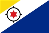
Bonaire
Encyclopedia
Bonaire is a special municipality (officially public body
) of the Netherlands
,(Law on the public bodies of Bonaire, Sint Eustatius and Saba) |work=Dutch Government |url=http://www.eerstekamer.nl/wetsvoorstel/31954_wet_openbare_lichamen |accessdate=14 October 2010}} consisting of the Caribbean
island of Bonaire and, nestled in its western crescent, the uninhabited islet of Klein Bonaire
. Together with Aruba
and Curaçao
it forms a group referred to as the ABC islands of the Leeward Antilles
, the southern island chain of the Lesser Antilles
. The name Bonaire is thought to have originally come from the Caiquetio word 'Bonay'. The early Spanish and Dutch modified its spelling to Bojnaj and also Bonaire, which means "Good Air".
Bonaire was part of the Netherlands Antilles
until the country's dissolution on 10 October 2010, when the island (including Klein Bonaire) became a special municipality within the country of the Netherlands.
s have been preserved in caves at Spelonk, Onima, Ceru Pungi, and Ceru Crita-Cabai. The Caquetios were apparently a very tall people, for the Spanish name for the ABC Islands was 'las Islas de los Gigantes' or 'the islands of the giants.'
arrived in Curaçao
and a neighboring island that was almost certainly Bonaire. Ojeda was accompanied by Amerigo Vespucci
and Juan de la Cosa
. De La Cosa's Mappa Mundi
of 1500 shows Bonaire and calls it Isla do Palo Brasil or "Island of Brazilwood
." The Spanish conquerors decided that the three ABC Islands were useless, and in 1515 the natives were forcibly deported to work as slaves in the copper mines of Santo Domingo on the island of Hispaniola.
which was safe from pirate attack.
was founded in 1621. Starting in 1623, ships of the West India Company called at Bonaire to obtain meat, water, and wood. The Dutch also abandoned some Spanish and Portuguese prisoners there, and these people founded the town of Antriol which is a contraction of "al interior" or "inside." The Dutch and the Spanish fought from 1568 to 1648 in what is now known as the Eighty Years War. In 1633, the Dutch, having lost the island of St. Maarten to the Spanish, retaliated by attacking Curaçao, Bonaire, and Aruba. Bonaire was conquered in March 1636. The Dutch built Fort Oranje in 1639. While Curaçao emerged as a center of the slave trade, Bonaire became a plantation of the Dutch West India Company. A small number of African slaves were put to work alongside Indians and convicts, cultivating dyewood and maize and harvesting solar salt
around Blue Pan. Slave quarters, built entirely of stone and too short for a man to stand upright in, still stand in the area around Rincon and along the saltpans as a grim reminder of Bonaire's repressive past.
, the Netherlands lost control of Bonaire twice, once from 1800–1803 and again from 1807-1816. During these intervals, the British had control of the neighboring island of Curaçao
and of Bonaire. The ABC islands were returned to the Netherlands under the Anglo-Dutch Treaty of 1814
. During the period of British rule, a large number of white traders settled on Bonaire, and they built the settlement of Playa (Kralendijk
) in 1810.
as an air force base. After Germany invaded the Netherlands on May 10, 1940, many Dutch and German citizens were interned in a camp on Bonaire for the duration of war. In 1944, Queen Juliana of the Netherlands and Eleanor Roosevelt
visited the troops on Bonaire.
. The Dutch Schunck
family built a clothing factory known as Schunck's Kledingindustrie Bonaire
. In 1964, Trans World Radio
began broadcasting from Bonaire. Radio Netherlands Worldwide built two short wave transmitters on Bonaire in 1969. The second major hotel (Bonaire Beach Hotel) was completed in 1962. Salt production resumed in 1966 when the salt pans were expanded and modernized by the Antilles International Salt Company, a subsidiary of the International Salt Company. The Bonaire Petroleum Corporation (BOPEC) oil terminal was opened in 1975 for trans-shipping oil
that was scheduled on March 26, 2010, on the future of the island of Bonaire was cancelled in February 2010. The Governor of the Dutch Antilles, Frits Goedgedrag
, decided to cancel it because it probably contravened international law, since part of the population is barred from voting. European Dutch nationals are only allowed to vote if they arrived on the island before January 1, 2007. The referendum was postponed to September and then October 2010. Eventually the referendum was held on December 17 2010, with 84% voting in favour of becoming part of the Netherlands. However as the 35% voter turnout
rate was below the required 51%, the results of the referendum were declared invalid.
On 10 October 2010 the Netherlands Antilles
was dissolved, making Bonaire a public body of the Netherlands
.
and is consistently rated among the best diving locations in the world. Bonaire's license plates carry the logo Divers Paradise (in English). Bonaire is also consistently recognized as one of the best destinations for snorkeling
. Wind surfers also make a strong group of island tourists, as the east side of the island (facing the Caribbean Sea) has the large waves and wind gusts needed for windsurfing. Lac Bay, in the south east, is shallow, yet windy, and hence is considered an excellent place for intermediate sailors to improve their skills. Tourism infrastructure in Bonaire is contemporary and based on time-share resorts. There are a few small bed and breakfast
s. Most resorts have an on-site dive shop. The rest are affiliated with a dive operation.
Today, the airport is currently known as Flamingo International Airport
and is currently served by a variety of both Domestic and International Airlines. Services from the US include, Continental Airlines, Delta Air Lines and Insel Air. Airlines providing European service include Arkefly and KLM. Consistent air service from Curaçao is available through Divi Divi Air, Dutch Antilles Express, EZAir and Insel Air, and also direct service from Aruba to Bonaire is provided by Tiara Air.
The airport comes equipped with a fire station, control tower, and hangar. Plans are underway for modifications to the current airport facilities, runway and the fire station.

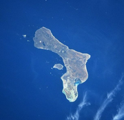
 Bonaire has a land area of 288 km² (111 sq. miles), while Klein Bonaire is a further 6 km² (2.3 sq. miles). Bonaire's Afdeling Bevolking (census) office reported that the population was 14,006 inhabitants as of December, 2006, which gives Bonaire island proper a population density of 49 inhabitants per km².
Bonaire lies outside the hurricane belt
, and is served by Flamingo International Airport
.
The island is ringed by a coral reef which is easily accessible from the shore along the Western and Southern sides. Furthermore, the entire coastline of the island has been declared a marine sanctuary, preserving local fish life.
The coral reef
around uninhabited Klein Bonaire
is particularly well preserved, and it draws divers, snorkelers, and boaters.
Bonaire also has several coral reefs where seahorse
s can be found.
Bonaire is also famed for its flamingo
populations and its donkey
sanctuary. Flamingos are drawn to the brackish water, which harbours the shrimp they feed on. Starting in the 16th century, the Dutch raised sheep, goats, pigs, horses and donkeys on Bonaire, and the descendants of the goats and donkeys roam the island today, with a small population of pigs roaming as well.
Washington Slagbaai National Park
, located at the north side of the island, is an ecological preserve. The highest point of Bonaire, the mountainous Brandaris, 787 feet (239.9 m) high, located within this preserve, has a complete view of the island.
Elsewhere, environmental issues are a cause for concern, particularly with unregulated and illegal dumping of raw sewage and chemical pollutants which leach through the permeable limestone of the island and threaten the quality of groundwater. This is particularly of concern at the landfill site, which environmentalists state has no impermeable membrane present to prevent possible groundwater contamination by toxic waste. Destruction of wildlife habitat for commercial development thus threatening endangered species is also highlighted as a problem.
Lac Bay, (also known as Lac Cai or Lac Cay) on the eastern side of the island, is a windsurfer's
paradise. Locals Taty and Tonky Frans in 2004 were ranked in the top five of the world's freestyle windsurfing professionals.
Atlantis Beach, on the western part of the island, is the local kitesurfing
spot.
Aside from the tourist sites, Bonaire has become home to Saint James School of Medicine
, which was founded by Physicians practicing and teaching basic/clinical medicine in the United States. Their goals encompass motivating students in the art of medicine utilizing a curriculum which parallels that of any U.S. based medical school.
There is also an offshore American Caribbean Medical Schools in Bonaire called Saint James School of Medicine
.
and Rincon.
Kralendijk has many suburbs/neighbourhoods (on an island with such a small population, the distinction is not always clearcut). Kralendijk's suburbs/neighbourhoods include:
Other smaller settlements include
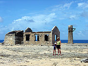
Labra, Ishiri, Kokorobi, Jan Doran, Vlijt, Rigot, Porto Spano, and Kunchi were several smaller towns that had existed in the national park, but were later abandoned.
is the official language on Bonaire, since it is part of the Netherlands. Nevertheless, Papiamentu is recognised as another language on the island.
operates on Bonaire a radio relay station with a mediumwave transmitter and several shortwave transmitters at 12°6′23"N 68°17′1"W. The mediumwave transmitter is the most powerful mediumwave transmitter in America, having operated with as much as a half megawatt (500 kilowatts).
The antenna of the mediumwave transmitter consists of four 231.6 metre-tall masts arranged in a parallelogram.
Island Information
Nature
News
WebCams
Public body (Netherlands)
In the Netherlands, the term public body is the general denomination for administrative divisions within the Dutch state, such as the central government, a province, a municipality or a water board...
) of the Netherlands
Netherlands
The Netherlands is a constituent country of the Kingdom of the Netherlands, located mainly in North-West Europe and with several islands in the Caribbean. Mainland Netherlands borders the North Sea to the north and west, Belgium to the south, and Germany to the east, and shares maritime borders...
,(Law on the public bodies of Bonaire, Sint Eustatius and Saba) |work=Dutch Government |url=http://www.eerstekamer.nl/wetsvoorstel/31954_wet_openbare_lichamen |accessdate=14 October 2010}} consisting of the Caribbean
Caribbean
The Caribbean is a crescent-shaped group of islands more than 2,000 miles long separating the Gulf of Mexico and the Caribbean Sea, to the west and south, from the Atlantic Ocean, to the east and north...
island of Bonaire and, nestled in its western crescent, the uninhabited islet of Klein Bonaire
Klein Bonaire
Klein Bonaire is a small uninhabited islet off the west coast of the Caribbean island of Bonaire, and is part of the Dutch special municipality of Bonaire. The islet, which sits within the rough crescent formed by the main island, is 6 square kilometres and extremely flat, rising no more than two...
. Together with Aruba
Aruba
Aruba is a 33 km-long island of the Lesser Antilles in the southern Caribbean Sea, located 27 km north of the coast of Venezuela and 130 km east of Guajira Peninsula...
and Curaçao
Curaçao
Curaçao is an island in the southern Caribbean Sea, off the Venezuelan coast. The Country of Curaçao , which includes the main island plus the small, uninhabited island of Klein Curaçao , is a constituent country of the Kingdom of the Netherlands...
it forms a group referred to as the ABC islands of the Leeward Antilles
Leeward Antilles
The Leeward Antilles are a chain of islands in the Caribbean – specifically, the southerly islands of the Lesser Antilles along the southeastern fringe of the Caribbean Sea, just north of the Venezuelan coast of the South American mainland...
, the southern island chain of the Lesser Antilles
Lesser Antilles
The Lesser Antilles are a long, partly volcanic island arc in the Western Hemisphere. Most of its islands form the eastern boundary of the Caribbean Sea with the Atlantic Ocean, with the remainder located in the southern Caribbean just north of South America...
. The name Bonaire is thought to have originally come from the Caiquetio word 'Bonay'. The early Spanish and Dutch modified its spelling to Bojnaj and also Bonaire, which means "Good Air".
Bonaire was part of the Netherlands Antilles
Netherlands Antilles
The Netherlands Antilles , also referred to informally as the Dutch Antilles, was an autonomous Caribbean country within the Kingdom of the Netherlands, consisting of two groups of islands in the Lesser Antilles: Aruba, Bonaire and Curaçao , in Leeward Antilles just off the Venezuelan coast; and Sint...
until the country's dissolution on 10 October 2010, when the island (including Klein Bonaire) became a special municipality within the country of the Netherlands.
Original Inhabitants
Bonaire's earliest known inhabitants were the Caquetios Indians, a branch of the Arawak who came by canoe from Venezuela in about AD 1000. Archeological remains of Caquetio culture have been found at certain sites northeast of Kralendijk and near Lac Bay. Caquieto rock paintings and petroglyphPetroglyph
Petroglyphs are pictogram and logogram images created by removing part of a rock surface by incising, picking, carving, and abrading. Outside North America, scholars often use terms such as "carving", "engraving", or other descriptions of the technique to refer to such images...
s have been preserved in caves at Spelonk, Onima, Ceru Pungi, and Ceru Crita-Cabai. The Caquetios were apparently a very tall people, for the Spanish name for the ABC Islands was 'las Islas de los Gigantes' or 'the islands of the giants.'
European Arrival
In 1499, Alonso de OjedaAlonso de Ojeda
Alonso de Ojeda was a Spanish navigator, governor and conquistador. His name is sometimes spelled Alonzo and Oxeda.-Early life:...
arrived in Curaçao
Curaçao
Curaçao is an island in the southern Caribbean Sea, off the Venezuelan coast. The Country of Curaçao , which includes the main island plus the small, uninhabited island of Klein Curaçao , is a constituent country of the Kingdom of the Netherlands...
and a neighboring island that was almost certainly Bonaire. Ojeda was accompanied by Amerigo Vespucci
Amerigo Vespucci
Amerigo Vespucci was an Italian explorer, financier, navigator and cartographer. The Americas are generally believed to have derived their name from the feminized Latin version of his first name.-Expeditions:...
and Juan de la Cosa
Juan de la Cosa
Juan de la Cosa was a Spanish cartographer, conquistador and explorer. He made the earliest extant European world map to incorporate the territories of the Americas that were discovered in the 15th century, sailed first 3 voyages with Christopher Columbus, and was the owner/captain of the Santa...
. De La Cosa's Mappa Mundi
Mappa mundi
Mappa mundi is a general term used to describe medieval European maps of the world. These maps range in size and complexity from simple schematic maps an inch or less across to elaborate wall maps, the largest of which was 11 ft. in diameter...
of 1500 shows Bonaire and calls it Isla do Palo Brasil or "Island of Brazilwood
Brazilwood
Caesalpinia echinata is a species of Brazilian timber tree in the pea family, Fabaceae. Common names include Brazilwood, Pau-Brasil, Pau de Pernambuco and Ibirapitanga . This plant has a dense, orange-red heartwood that takes a high shine, and it is the premier wood used for making bows for...
." The Spanish conquerors decided that the three ABC Islands were useless, and in 1515 the natives were forcibly deported to work as slaves in the copper mines of Santo Domingo on the island of Hispaniola.
Spanish Period
In 1526, Juan de Ampies was appointed Spanish commander of the ABC Islands. He brought back some of the original Caquetios Indian inhabitants to Bonaire and Curaçao. Ampies also imported domesticated animals from Spain, including cows, donkeys, goats, horses, pigs, and sheep. The Spaniards thought that Bonaire could be used as a cattle plantation worked by natives. The cattle were raised for hides rather than meat. The Spanish inhabitants lived mostly in the inland town of RinconRincon, Bonaire
Rincon is one of the two towns on Bonaire, one of the five islands of the Netherlands Antilles. It is situated in the north of the island in an inland valley. It was established in the 16th century by the Spanish...
which was safe from pirate attack.
Dutch Period
The Dutch West India CompanyDutch West India Company
Dutch West India Company was a chartered company of Dutch merchants. Among its founding fathers was Willem Usselincx...
was founded in 1621. Starting in 1623, ships of the West India Company called at Bonaire to obtain meat, water, and wood. The Dutch also abandoned some Spanish and Portuguese prisoners there, and these people founded the town of Antriol which is a contraction of "al interior" or "inside." The Dutch and the Spanish fought from 1568 to 1648 in what is now known as the Eighty Years War. In 1633, the Dutch, having lost the island of St. Maarten to the Spanish, retaliated by attacking Curaçao, Bonaire, and Aruba. Bonaire was conquered in March 1636. The Dutch built Fort Oranje in 1639. While Curaçao emerged as a center of the slave trade, Bonaire became a plantation of the Dutch West India Company. A small number of African slaves were put to work alongside Indians and convicts, cultivating dyewood and maize and harvesting solar salt
Edible salt
Salt, also known as table salt, or rock salt, is a mineral that is composed primarily of sodium chloride , a chemical compound belonging to the larger class of ionic salts. It is essential for animal life in small quantities, but is harmful to animals and plants in excess...
around Blue Pan. Slave quarters, built entirely of stone and too short for a man to stand upright in, still stand in the area around Rincon and along the saltpans as a grim reminder of Bonaire's repressive past.
British Period
During the Napoleonic WarsNapoleonic Wars
The Napoleonic Wars were a series of wars declared against Napoleon's French Empire by opposing coalitions that ran from 1803 to 1815. As a continuation of the wars sparked by the French Revolution of 1789, they revolutionised European armies and played out on an unprecedented scale, mainly due to...
, the Netherlands lost control of Bonaire twice, once from 1800–1803 and again from 1807-1816. During these intervals, the British had control of the neighboring island of Curaçao
Curaçao
Curaçao is an island in the southern Caribbean Sea, off the Venezuelan coast. The Country of Curaçao , which includes the main island plus the small, uninhabited island of Klein Curaçao , is a constituent country of the Kingdom of the Netherlands...
and of Bonaire. The ABC islands were returned to the Netherlands under the Anglo-Dutch Treaty of 1814
Anglo-Dutch Treaty of 1814
The Anglo-Dutch Treaty of 1814 was a treaty signed between Great Britain and the Netherlands in London on August 13, 1814...
. During the period of British rule, a large number of white traders settled on Bonaire, and they built the settlement of Playa (Kralendijk
Kralendijk
Kralendijk is the capital city and main port of the island of Bonaire in the Caribbean Netherlands. The language spoken in the town is Papiamentu, but Dutch and English are widely used. In Dutch, Kralendijk means "coral reef" or "coral dike". The Papiamentu name for the town is Playa or "beach"...
) in 1810.
Emancipation
From 1816 until 1868, Bonaire remained a government plantation. In 1825, there were about 300 government-owned slaves on the island. Gradually many of the slaves were freed, and became freemen with an obligation to render some services to the government. The remaining slaves were freed on September 30, 1862 under the Emancipation Regulation. A total of 607 government slaves and 151 private slaves were freed at that time.Allotment
In 1867 the government sold most of the public lands, and in 1870 they sold the saltpans. The entire population became dependent on two large private landowners, and this caused a great deal of suffering for many people. Many inhabitants were forced to move to Aruba, Curaçao, or Venezuela.World War II
During the German occupation of the Netherlands during World War II, Bonaire was a protectorate of Britain and the United States. The American army built the Flamingo AirportFlamingo International Airport
Flamingo International Airport or Bonaire International Airport is an international airport located at Kralendijk, Bonaire, Netherlands. The Flamingo Airport serves as a connecting point for flights of KLM to some airports in South America...
as an air force base. After Germany invaded the Netherlands on May 10, 1940, many Dutch and German citizens were interned in a camp on Bonaire for the duration of war. In 1944, Queen Juliana of the Netherlands and Eleanor Roosevelt
Eleanor Roosevelt
Anna Eleanor Roosevelt was the First Lady of the United States from 1933 to 1945. She supported the New Deal policies of her husband, distant cousin Franklin Delano Roosevelt, and became an advocate for civil rights. After her husband's death in 1945, Roosevelt continued to be an international...
visited the troops on Bonaire.
Post War
After the war, the economy of Bonaire continued to develop. The airport was converted to civilian use, and the former internment camp was converted to become the first hotel on Bonaire. The Dutch Schunck
Schunck
Schunck is the name of former fashion house and department store Firma Schunck in Heerlen, the Netherlands. It is also the name for the collection of buildings the firm has been housed in, one of which is known as the Glaspaleis , which is now a cultural centre and declared one of the 1000 most...
family built a clothing factory known as Schunck's Kledingindustrie Bonaire
Schunck's Kledingindustrie Bonaire
In 1948, Pierre Schunck , stemming from a family of weavers and son of the builder of the famous Glaspaleis in Heerlen, the Netherlands , arrived in Bonaire to set up a clothing industry ...
. In 1964, Trans World Radio
Trans World Radio
Trans World Radio is a multinational Christian evangelistic broadcaster. TWR broadcasts from 14 countries using mediumwave or high-powered AM transmitters, shortwave as well as through local radio stations, cable, satellite, and the Internet to reach millions of people in 160 nations in their own...
began broadcasting from Bonaire. Radio Netherlands Worldwide built two short wave transmitters on Bonaire in 1969. The second major hotel (Bonaire Beach Hotel) was completed in 1962. Salt production resumed in 1966 when the salt pans were expanded and modernized by the Antilles International Salt Company, a subsidiary of the International Salt Company. The Bonaire Petroleum Corporation (BOPEC) oil terminal was opened in 1975 for trans-shipping oil
Referendum 2010
An announced referendumBonaire constitutional referendum, 2010
The Bonaire constitutional referendum of 2010 was originally scheduled to take place on January 15, 2010. The Bonairean Executive Council later voted to hold it on 26 March 2010, but Lieutenant Governor Glenn Thode requested that the enabling legislation be cancelled, citing his belief that it...
that was scheduled on March 26, 2010, on the future of the island of Bonaire was cancelled in February 2010. The Governor of the Dutch Antilles, Frits Goedgedrag
Frits Goedgedrag
Frits M. de los Santos Goedgedrag is the current and first Governor of Curaçao. From 1 July 2002 to 9 October 2010, Goedgedrag was the Governor of the Netherlands Antilles. From 1992 to 1998, he was Administrator of Bonaire....
, decided to cancel it because it probably contravened international law, since part of the population is barred from voting. European Dutch nationals are only allowed to vote if they arrived on the island before January 1, 2007. The referendum was postponed to September and then October 2010. Eventually the referendum was held on December 17 2010, with 84% voting in favour of becoming part of the Netherlands. However as the 35% voter turnout
Voter turnout
Voter turnout is the percentage of eligible voters who cast a ballot in an election . After increasing for many decades, there has been a trend of decreasing voter turnout in most established democracies since the 1960s...
rate was below the required 51%, the results of the referendum were declared invalid.
On 10 October 2010 the Netherlands Antilles
Netherlands Antilles
The Netherlands Antilles , also referred to informally as the Dutch Antilles, was an autonomous Caribbean country within the Kingdom of the Netherlands, consisting of two groups of islands in the Lesser Antilles: Aruba, Bonaire and Curaçao , in Leeward Antilles just off the Venezuelan coast; and Sint...
was dissolved, making Bonaire a public body of the Netherlands
Netherlands
The Netherlands is a constituent country of the Kingdom of the Netherlands, located mainly in North-West Europe and with several islands in the Caribbean. Mainland Netherlands borders the North Sea to the north and west, Belgium to the south, and Germany to the east, and shares maritime borders...
.
Tourism
Bonaire's economy is mainly based on tourism. The island caters mainly to scuba divers and snorkelers, as there are few sandy beaches, while the surrounding reefs are easily accessible from the shore. Bonaire is world renowned for its excellent scuba divingScuba diving
Scuba diving is a form of underwater diving in which a diver uses a scuba set to breathe underwater....
and is consistently rated among the best diving locations in the world. Bonaire's license plates carry the logo Divers Paradise (in English). Bonaire is also consistently recognized as one of the best destinations for snorkeling
Snorkeling
Snorkeling is the practice of swimming on or through a body of water while equipped with a diving mask, a shaped tube called a snorkel, and usually swimfins. In cooler waters, a wetsuit may also be worn...
. Wind surfers also make a strong group of island tourists, as the east side of the island (facing the Caribbean Sea) has the large waves and wind gusts needed for windsurfing. Lac Bay, in the south east, is shallow, yet windy, and hence is considered an excellent place for intermediate sailors to improve their skills. Tourism infrastructure in Bonaire is contemporary and based on time-share resorts. There are a few small bed and breakfast
Bed and breakfast
A bed and breakfast is a small lodging establishment that offers overnight accommodation and breakfast, but usually does not offer other meals. Since the 1980s, the meaning of the term has also extended to include accommodations that are also known as "self-catering" establishments...
s. Most resorts have an on-site dive shop. The rest are affiliated with a dive operation.
Transportation
Bonaire's first airport was located near Tra'i Montaña Subi Blanku and walked across the current path of Kralendijk to Rincon and was built in 1936. The airport proved to be too small when American soldiers arrived on Bonaire in the second half of 1943 commander stated that a new airport had to be built. In December 1943, construction began in the vicinity of where the present airport now stands. The new airport, named "Flamingo Airport", was put into use in 1945. A small terminal was built that was suitable for the number of passengers at the time. This building was used until mid 1976. The airport had received many extensions of both the runway and the terminal itself.Today, the airport is currently known as Flamingo International Airport
Flamingo International Airport
Flamingo International Airport or Bonaire International Airport is an international airport located at Kralendijk, Bonaire, Netherlands. The Flamingo Airport serves as a connecting point for flights of KLM to some airports in South America...
and is currently served by a variety of both Domestic and International Airlines. Services from the US include, Continental Airlines, Delta Air Lines and Insel Air. Airlines providing European service include Arkefly and KLM. Consistent air service from Curaçao is available through Divi Divi Air, Dutch Antilles Express, EZAir and Insel Air, and also direct service from Aruba to Bonaire is provided by Tiara Air.
The airport comes equipped with a fire station, control tower, and hangar. Plans are underway for modifications to the current airport facilities, runway and the fire station.
Geography
Bonaire lies outside the hurricane belt
Hurricane belt
The hurricane belt is an area in the Atlantic Ocean, including the Caribbean Sea and Gulf of Mexico, which is prone to hurricanes during the Atlantic hurricane season....
, and is served by Flamingo International Airport
Flamingo International Airport
Flamingo International Airport or Bonaire International Airport is an international airport located at Kralendijk, Bonaire, Netherlands. The Flamingo Airport serves as a connecting point for flights of KLM to some airports in South America...
.
The island is ringed by a coral reef which is easily accessible from the shore along the Western and Southern sides. Furthermore, the entire coastline of the island has been declared a marine sanctuary, preserving local fish life.
The coral reef
Coral reef
Coral reefs are underwater structures made from calcium carbonate secreted by corals. Coral reefs are colonies of tiny living animals found in marine waters that contain few nutrients. Most coral reefs are built from stony corals, which in turn consist of polyps that cluster in groups. The polyps...
around uninhabited Klein Bonaire
Klein Bonaire
Klein Bonaire is a small uninhabited islet off the west coast of the Caribbean island of Bonaire, and is part of the Dutch special municipality of Bonaire. The islet, which sits within the rough crescent formed by the main island, is 6 square kilometres and extremely flat, rising no more than two...
is particularly well preserved, and it draws divers, snorkelers, and boaters.
Bonaire also has several coral reefs where seahorse
Seahorse
Seahorses compose the fish genus Hippocampus within the family Syngnathidae, in order Syngnathiformes. Syngnathidae also includes the pipefishes. "Hippocampus" comes from the Ancient Greek hippos meaning "horse" and kampos meaning “sea monster”.There are nearly 50 species of seahorse...
s can be found.
Bonaire is also famed for its flamingo
Flamingo
Flamingos or flamingoes are gregarious wading birds in the genus Phoenicopterus , the only genus in the family Phoenicopteridae...
populations and its donkey
Donkey
The donkey or ass, Equus africanus asinus, is a domesticated member of the Equidae or horse family. The wild ancestor of the donkey is the African Wild Ass, E...
sanctuary. Flamingos are drawn to the brackish water, which harbours the shrimp they feed on. Starting in the 16th century, the Dutch raised sheep, goats, pigs, horses and donkeys on Bonaire, and the descendants of the goats and donkeys roam the island today, with a small population of pigs roaming as well.
Washington Slagbaai National Park
Washington Slagbaai National Park
Washington Slagbaai National Park is an ecological reserve on the northwestern part of Bonaire. It is managed by STINAPA Bonaire. Established in 1969, Washington Slagbaai was the first nature reserve to be established in the Netherlands Antilles, covering approximately a fifth of the...
, located at the north side of the island, is an ecological preserve. The highest point of Bonaire, the mountainous Brandaris, 787 feet (239.9 m) high, located within this preserve, has a complete view of the island.
Elsewhere, environmental issues are a cause for concern, particularly with unregulated and illegal dumping of raw sewage and chemical pollutants which leach through the permeable limestone of the island and threaten the quality of groundwater. This is particularly of concern at the landfill site, which environmentalists state has no impermeable membrane present to prevent possible groundwater contamination by toxic waste. Destruction of wildlife habitat for commercial development thus threatening endangered species is also highlighted as a problem.
Lac Bay, (also known as Lac Cai or Lac Cay) on the eastern side of the island, is a windsurfer's
Windsurfing
Windsurfing or sailboarding is a surface water sport that combines elements of surfing and sailing. It consists of a board usually two to four metres long, powered by the orthogonal effect of the wind on a sail. The rig is connected to the board by a free-rotating universal joint and comprises a...
paradise. Locals Taty and Tonky Frans in 2004 were ranked in the top five of the world's freestyle windsurfing professionals.
Atlantis Beach, on the western part of the island, is the local kitesurfing
Kitesurfing
Kitesurfing or Kiteboarding is an adventure surface water sport that has been described as combining wakeboarding, windsurfing, surfing, paragliding, and gymnastics into one extreme sport. Kitesurfing harnesses the power of the wind to propel a rider across the water on a small surfboard or a...
spot.
Aside from the tourist sites, Bonaire has become home to Saint James School of Medicine
Saint James School of Medicine
Saint James School of Medicine is a is a private, for-profit medical school located in Kralendijk, Bonaire, in the Caribbean. Saint James confers upon its graduates the Doctor of Medicine degree...
, which was founded by Physicians practicing and teaching basic/clinical medicine in the United States. Their goals encompass motivating students in the art of medicine utilizing a curriculum which parallels that of any U.S. based medical school.
Education
Bonaire’s educational system is patterned after the Dutch system. Early grades are taught solely in Papiamentu, with more and more Dutch being introduced as the grade level progresses.There is also an offshore American Caribbean Medical Schools in Bonaire called Saint James School of Medicine
Saint James School of Medicine
Saint James School of Medicine is a is a private, for-profit medical school located in Kralendijk, Bonaire, in the Caribbean. Saint James confers upon its graduates the Doctor of Medicine degree...
.
Settlements
The only generally recognized towns on the island are KralendijkKralendijk
Kralendijk is the capital city and main port of the island of Bonaire in the Caribbean Netherlands. The language spoken in the town is Papiamentu, but Dutch and English are widely used. In Dutch, Kralendijk means "coral reef" or "coral dike". The Papiamentu name for the town is Playa or "beach"...
and Rincon.
Kralendijk has many suburbs/neighbourhoods (on an island with such a small population, the distinction is not always clearcut). Kralendijk's suburbs/neighbourhoods include:
- Antriol
- Belnem
- Hato
- Lima
- Noord Salina
- Nikiboko
- Republiek
- Sabadeco
- Sabana
- Santa Barbara
- Tera Cora
Other smaller settlements include
- Fontein
- Lagoen
- Sorobon
- Spelonk
- Wanapa
Labra, Ishiri, Kokorobi, Jan Doran, Vlijt, Rigot, Porto Spano, and Kunchi were several smaller towns that had existed in the national park, but were later abandoned.
Languages
DutchDutch language
Dutch is a West Germanic language and the native language of the majority of the population of the Netherlands, Belgium, and Suriname, the three member states of the Dutch Language Union. Most speakers live in the European Union, where it is a first language for about 23 million and a second...
is the official language on Bonaire, since it is part of the Netherlands. Nevertheless, Papiamentu is recognised as another language on the island.
Trans World Radio relay station
Trans World RadioTrans World Radio
Trans World Radio is a multinational Christian evangelistic broadcaster. TWR broadcasts from 14 countries using mediumwave or high-powered AM transmitters, shortwave as well as through local radio stations, cable, satellite, and the Internet to reach millions of people in 160 nations in their own...
operates on Bonaire a radio relay station with a mediumwave transmitter and several shortwave transmitters at 12°6′23"N 68°17′1"W. The mediumwave transmitter is the most powerful mediumwave transmitter in America, having operated with as much as a half megawatt (500 kilowatts).
The antenna of the mediumwave transmitter consists of four 231.6 metre-tall masts arranged in a parallelogram.
Radio Netherlands relay station
Radio Netherlands Worldwide operate a shortwave relay station at 12°12′48"N 68°19′23"W.See also
- Caribbean Netherlands
- Caribbean SeaCaribbean SeaThe Caribbean Sea is a sea of the Atlantic Ocean located in the tropics of the Western hemisphere. It is bounded by Mexico and Central America to the west and southwest, to the north by the Greater Antilles, and to the east by the Lesser Antilles....
- Leeward AntillesLeeward AntillesThe Leeward Antilles are a chain of islands in the Caribbean – specifically, the southerly islands of the Lesser Antilles along the southeastern fringe of the Caribbean Sea, just north of the Venezuelan coast of the South American mainland...
External links
Government- www.gov.an - official governmental portal of the Netherlands Antilles
- Bonairegov.nl - official website of the government of Bonaire
- BonaireEconomy.org - Department of Economic & Labour Affairs (DEZA)
Island Information
- TourismBonaire.com - The Official Bonaire Tourism Site
- BONHATA - Bonaire Hotel and Tourism Association
- Lonely Planet - Bonaire
- Bonaireviews.com Bonaire website with panorama photos
Nature
News
- Bonaire Reporter - English language weekly newssheet about Bonaire
WebCams
- Breathe Bonaire - Live webcams from Bonaire (including the first megapixel underwater webcam)
- BonaireWebCams.com - Live webcams from the island of Bonaire