
Mount Waddington
Encyclopedia
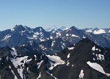
Mount Waddington, once known as Mystery Mountain, is the highest peak in the Coast Mountains
of British Columbia
, Canada
. Although Mount Fairweather
and Mount Quincy Adams
, which straddle the US border between Alaska
and British Columbia are taller, Mount Waddington is the highest peak that lies entirely within British Columbia. It and the subrange which surround it, known as the Waddington Range
, stand at the heart of the Pacific Ranges
, a remote and extremely difficult set of mountains and river valleys.
It is not so far north as its extreme Arctic-like conditions might indicate and Mount Waddington and its attendant peaks pose some of the most serious expedition mountaineering to be had in North America
— and some of the most extreme relief and spectacular mountain scenery.
From Waddington's 13,186 ft fang to sea level at the heads of Bute
and Knight Inlet
s is only a few miles; across the 10000 feet (3,048 m) gorges of the Homathko
and the Klinaklini River
s stand mountains almost as high, and icefields even vaster and whiter, only a few aerial miles away, with a maw deeper than the Grand Canyon
, comparable in relief to the Himalayas
(to which the terrain of British Columbia was compared by colonial-era travellers).
Mount Waddington is the namesake of the Mount Waddington Regional District
, which takes in the seaward slope of the Waddington Range and the adjoining coastline and parts of northern Vancouver Island adjacent to Queen Charlotte Strait
.
, Vancouver Island
, Don
and Phyllis Munday
spotted what they believed to be a peak taller than Mount Robson
, then accepted as the tallest peak entirely within British Columbia
. In the words of Don Munday
"The compass showed the alluring peak stood along a line passing a little east of Bute Inlet
and perhaps 150 miles away, where blank spaces on the map left ample room for many nameless mountains." While there is debate as to whether the peak they saw was Mount Waddington (Don Munday observed that the feat is impossible), they almost certainly saw a peak in the Waddington Range
, and this led the Mundays to explore that area.
Over the next decade, the Mundays mounted several expeditions into the area in an attempt to climb it. Known to them as "The Mystery Mountain", in 1927 the height was measured at 13,260 feet by triangulation; they reached the lower summit in 1928, deeming the main summit too risky. On their recommendation the Geographical Names Board of Canada
gave it the name Mount Waddington after Alfred Waddington
who was a proponent of a road route, known as Waddington's Road, and again later the same for a railway, via the Homathko River
valley and Bute Inlet
, which would connect to Vancouver Island via Seymour Narrows
.
In the summer of 1934, two expeditions attempted to climb the mountain. The first expedition, made up of climbers from Winnipeg
, made their attempt on the northwestern flank which had not been explored by the Mundays. After crossing Tatlayoko Lake
and making their way down the Homathko River, they then spent two days constructing a bridge over Nude Creek before reaching the Tiedemann Glacier on June 23. It took them three days to reach the shoulder of Mt. Waddington at 3200 m (10,498.7 ft). They attempted the summit on June 28 but poor weather and route conditions on the final tower forced them to retreat, 180 m (590.6 ft) from the top. The second expedition, consisting of climbers from British Columbia, made their attempt from the southeast. On June 23, they established their base camp on the Franklin Glacier. The ascent abruptly ended three days later when one of the climbers fell to his death from the southeast ridge. In 1935, a group of climbers from the Sierra Club of California made three attempts from their base camp at the Dais Glacier. The group failed in two attempts on the south face due to stormy conditions, poor route conditions and falling ice. Two climbers succeeded in reaching the northwest summit (first climbed by the Mundays) on a third attempt but proceeded no further.
, Bill House, Elizabeth Woolsey and Alan Willcox reached the head of the Knight Inlet
. For the next twelve days they ferried loads to their base camp at Icefall Point on the Dais Glacier. While on the glacier, they were joined by another expedition led by members of the British Columbia Mountaineering Club
and the Sierra Club
. Wiessner and House agreed to allow the others a first chance at the summit but this group failed to find a route up the south face.
On July 20, Wiessner and House first attempted the line of a great couloir
that comes directly down between the main summit tower and the northwest peak. It was an excellent line for quickly ascending but they were unable to traverse onto the south face proper due to poor rock conditions and were forced to retreat to base camp. By 3 am the next morning they were already climbing up a couloir to the right of the face. Good weather the past few days had cleared most of the snow away from the ledges making for good climbing conditions. Following the left branch of the couloir, they reached a snow patch in the middle of the face. The final 1000 ft (304.8 m) of the south face then presented a fierce hurdle of "sheer forbidding-looking rocks" as noted by Wiessner. While Wiessner initially started in boots, he quickly changed to rope-soled shoes and gave his ice axe and extra rope to House. Wiessner led several pitches up technically difficult rock including several overhangs. After traversing east across the face they rested on a ledge just below the southeastern ridge, a full 9 hours since leaving the snow patch on the south face. After climbing a short chimney they finally reached the small snowy mass at the top, 13 hours after their start in base camp. They aborted their earlier plan of descending the shorter north face and retraced their ascent line, reaching their tent on the Dais Glacier at 2 am. The ascent to the summit and back to base camp had taken over 23 hours.
massif is known for fierce as well as unpredictable weather, located as it is at the brunt of the warm, wet winds that soak the British Columbia Coast, of which it is the highest point. Precipitation levels in the area of the peak are among the highest in the Coast Mountains
.
and the Knight Inlet
, taking up to three days. A shorter water approach from Port McNeill, British Columbia, a northern community of Vancouver Island accessible by scheduled daily air connections and/or road from Victoria, reducing the water journey to less than a day may be undertaken.
Alternately trails and rough roads do exist from the Chilcotin
side of the range, and may be accessed via BC Highway 20, from Williams Lake
, departing from the main route to Bella Coola
at Tatla Lake to connect to the Homathko River
and up a side creek or glacier from there. This inland route is also the access route for the neighbouring Niut
and Pantheon Range
s.
Mount Waddington is a popular destination among mountain climbers since it is the highest peak in the Coast Mountains and a challenging climb. It has been compared to Mont Blanc
's structure.
Coast Mountains
The Coast Mountains are a major mountain range, in the Pacific Coast Ranges, of western North America, extending from southwestern Yukon through the Alaska Panhandle and virtually all of the Coast of British Columbia. They are so-named because of their proximity to the sea coast, and are often...
of British Columbia
British Columbia
British Columbia is the westernmost of Canada's provinces and is known for its natural beauty, as reflected in its Latin motto, Splendor sine occasu . Its name was chosen by Queen Victoria in 1858...
, Canada
Canada
Canada is a North American country consisting of ten provinces and three territories. Located in the northern part of the continent, it extends from the Atlantic Ocean in the east to the Pacific Ocean in the west, and northward into the Arctic Ocean...
. Although Mount Fairweather
Mount Fairweather
Mount Fairweather , is one of the world's highest coastal mountains at 4,671 metres It is located east of the Pacific Ocean on the border of Alaska, United States and western British Columbia, Canada...
and Mount Quincy Adams
Mount Quincy Adams (Fairweather Range)
Mount Quincy Adams is a mountain located on the border between United States and Canada. It is named after John Quincy Adams , the sixth president of the United States....
, which straddle the US border between Alaska
Alaska
Alaska is the largest state in the United States by area. It is situated in the northwest extremity of the North American continent, with Canada to the east, the Arctic Ocean to the north, and the Pacific Ocean to the west and south, with Russia further west across the Bering Strait...
and British Columbia are taller, Mount Waddington is the highest peak that lies entirely within British Columbia. It and the subrange which surround it, known as the Waddington Range
Waddington Range
The Waddington Range is a subrange of the Pacific Ranges of the Coast Mountains in southwestern British Columbia, Canada. It is only about 4000 km² in area, relatively small in area within the expanse of the range, but it is the highest area of the Pacific Ranges and of the Coast Mountains, being...
, stand at the heart of the Pacific Ranges
Pacific Ranges
The Pacific Ranges are the southernmost subdivision of the Coast Mountains portion of the Pacific Cordillera. Located entirely within British Columbia, Canada, they run northwest from the lower stretches of the Fraser River to Bella Coola, north of which are the Kitimat Ranges.The Pacific Ranges...
, a remote and extremely difficult set of mountains and river valleys.
It is not so far north as its extreme Arctic-like conditions might indicate and Mount Waddington and its attendant peaks pose some of the most serious expedition mountaineering to be had in North America
North America
North America is a continent wholly within the Northern Hemisphere and almost wholly within the Western Hemisphere. It is also considered a northern subcontinent of the Americas...
— and some of the most extreme relief and spectacular mountain scenery.
From Waddington's 13,186 ft fang to sea level at the heads of Bute
Bute Inlet
Bute Inlet is one of the principal inlets of the British Columbia Coast. It is 80 km long from its head at the mouths of the Homathko and Southgate Rivers to the continental headlands at its mouth, where it is nearly blocked by Stuart Island, and it averages about 4 km in width...
and Knight Inlet
Knight Inlet
Knight Inlet is one of the principal inlets of the British Columbia Coast, and the largest of the major inlets in the southern part of the Coast...
s is only a few miles; across the 10000 feet (3,048 m) gorges of the Homathko
Homathko River
The Homathko River is one of the major rivers of the southern Coast Mountains of British Columbia, and one of the few rivers that penetrates the range from the Chilcotin Plateau to the coastal inlets, entering the sea at the head of Bute Inlet adjacent to the mouth of the Southgate River, just to...
and the Klinaklini River
Klinaklini River
The Klinaklini River is one of the major rivers of the Pacific Ranges section of the Coast Mountains in British Columbia. It begins in the northern basins of the Pantheon Range to the north of Mount Waddington and briefly heads northeast onto the Chilcotin Plateau before bending around...
s stand mountains almost as high, and icefields even vaster and whiter, only a few aerial miles away, with a maw deeper than the Grand Canyon
Grand Canyon
The Grand Canyon is a steep-sided canyon carved by the Colorado River in the United States in the state of Arizona. It is largely contained within the Grand Canyon National Park, the 15th national park in the United States...
, comparable in relief to the Himalayas
Himalayas
The Himalaya Range or Himalaya Mountains Sanskrit: Devanagari: हिमालय, literally "abode of snow"), usually called the Himalayas or Himalaya for short, is a mountain range in Asia, separating the Indian subcontinent from the Tibetan Plateau...
(to which the terrain of British Columbia was compared by colonial-era travellers).
Mount Waddington is the namesake of the Mount Waddington Regional District
Regional District of Mount Waddington, British Columbia
The Regional District of Mount Waddington is a regional district in British Columbia. It takes in the lower Central Coast region centred around the Queen Charlotte Strait coast of northern Vancouver Island and the adjoining parts of mainland British Columbia...
, which takes in the seaward slope of the Waddington Range and the adjoining coastline and parts of northern Vancouver Island adjacent to Queen Charlotte Strait
Queen Charlotte Strait
Queen Charlotte Strait is a strait between Vancouver Island and the mainland of British Columbia, Canada. It connects Queen Charlotte Sound with Johnstone Strait, Discovery Passage and then to the Strait of Georgia and Puget Sound...
.
Discovery and exploration
In 1925, while on a trip to Mount ArrowsmithMount Arrowsmith
Mount Arrowsmith is the largest mountain on southern Vancouver Island. Its dominant rock is basalt. The mountain is contained within a UNESCO Biosphere Reserve and as of September 18, 2009 is designated part of 1,300 hectare Mt. Arrowsmith Regional Park....
, Vancouver Island
Vancouver Island
Vancouver Island is a large island in British Columbia, Canada. It is one of several North American locations named after George Vancouver, the British Royal Navy officer who explored the Pacific Northwest coast of North America between 1791 and 1794...
, Don
Don Munday
Walter Alfred Don Munday was a Canadian explorer, naturalist and mountaineer famous for his explorations of the Coast Mountains with his wife Phyllis, and especially for the exploration of the Waddington Range....
and Phyllis Munday
Phyllis Munday
Phyllis B Munday, CM was a Canadian mountaineer, explorer, naturalist and humanitarian, famed for being the first woman to reach the summit of Mount Robson in 1924, and with her husband Don for discovering Mount Waddington, and exploring the area around it via the Franklin River and the Homathko...
spotted what they believed to be a peak taller than Mount Robson
Mount Robson
Mount Robson is the most prominent mountain in North America's Rocky Mountain range; it is also the highest point in the Canadian Rockies. The mountain is located entirely within Mount Robson Provincial Park of British Columbia, and is part of the Rainbow Range. It is commonly thought to be the...
, then accepted as the tallest peak entirely within British Columbia
British Columbia
British Columbia is the westernmost of Canada's provinces and is known for its natural beauty, as reflected in its Latin motto, Splendor sine occasu . Its name was chosen by Queen Victoria in 1858...
. In the words of Don Munday
"The compass showed the alluring peak stood along a line passing a little east of Bute Inlet
Bute Inlet
Bute Inlet is one of the principal inlets of the British Columbia Coast. It is 80 km long from its head at the mouths of the Homathko and Southgate Rivers to the continental headlands at its mouth, where it is nearly blocked by Stuart Island, and it averages about 4 km in width...
and perhaps 150 miles away, where blank spaces on the map left ample room for many nameless mountains." While there is debate as to whether the peak they saw was Mount Waddington (Don Munday observed that the feat is impossible), they almost certainly saw a peak in the Waddington Range
Waddington Range
The Waddington Range is a subrange of the Pacific Ranges of the Coast Mountains in southwestern British Columbia, Canada. It is only about 4000 km² in area, relatively small in area within the expanse of the range, but it is the highest area of the Pacific Ranges and of the Coast Mountains, being...
, and this led the Mundays to explore that area.
Over the next decade, the Mundays mounted several expeditions into the area in an attempt to climb it. Known to them as "The Mystery Mountain", in 1927 the height was measured at 13,260 feet by triangulation; they reached the lower summit in 1928, deeming the main summit too risky. On their recommendation the Geographical Names Board of Canada
Geographical Names Board of Canada
Geographical Names Board of Canada is a national committee of the Canadian Government Department of Natural Resources which authorizes the names used on official federal government maps of Canada since 1897. The board consists of 27 members including one from each of the provinces and territories...
gave it the name Mount Waddington after Alfred Waddington
Alfred Waddington
Alfred Penderell Waddington was born in 1801 in the Brompton, Kensington, district of London, England. During his later years, Waddington was actively involved in the Colony of Vancouver Island in what later became the province of British Columbia, Canada....
who was a proponent of a road route, known as Waddington's Road, and again later the same for a railway, via the Homathko River
Homathko River
The Homathko River is one of the major rivers of the southern Coast Mountains of British Columbia, and one of the few rivers that penetrates the range from the Chilcotin Plateau to the coastal inlets, entering the sea at the head of Bute Inlet adjacent to the mouth of the Southgate River, just to...
valley and Bute Inlet
Bute Inlet
Bute Inlet is one of the principal inlets of the British Columbia Coast. It is 80 km long from its head at the mouths of the Homathko and Southgate Rivers to the continental headlands at its mouth, where it is nearly blocked by Stuart Island, and it averages about 4 km in width...
, which would connect to Vancouver Island via Seymour Narrows
Seymour Narrows
Seymour Narrows is a section of the Discovery Passage in British Columbia known for strong tidal currents. Discovery Passage lies between Vancouver Island at Menzies Bay, British Columbia and Quadra Island except at its northern end where the eastern shoreline is Sonora Island...
.
In the summer of 1934, two expeditions attempted to climb the mountain. The first expedition, made up of climbers from Winnipeg
Winnipeg
Winnipeg is the capital and largest city of Manitoba, Canada, and is the primary municipality of the Winnipeg Capital Region, with more than half of Manitoba's population. It is located near the longitudinal centre of North America, at the confluence of the Red and Assiniboine Rivers .The name...
, made their attempt on the northwestern flank which had not been explored by the Mundays. After crossing Tatlayoko Lake
Tatlayoko Lake
Tatlayoko Lake is a lake on the Homathko River in the western Chilcotin District of the Central Interior of British Columbia, Canada, located on a north-south axis just upstream of the entrance of the series of canyons of the Homathko, including the Great Canyon of the Homathko, on its route to the...
and making their way down the Homathko River, they then spent two days constructing a bridge over Nude Creek before reaching the Tiedemann Glacier on June 23. It took them three days to reach the shoulder of Mt. Waddington at 3200 m (10,498.7 ft). They attempted the summit on June 28 but poor weather and route conditions on the final tower forced them to retreat, 180 m (590.6 ft) from the top. The second expedition, consisting of climbers from British Columbia, made their attempt from the southeast. On June 23, they established their base camp on the Franklin Glacier. The ascent abruptly ended three days later when one of the climbers fell to his death from the southeast ridge. In 1935, a group of climbers from the Sierra Club of California made three attempts from their base camp at the Dais Glacier. The group failed in two attempts on the south face due to stormy conditions, poor route conditions and falling ice. Two climbers succeeded in reaching the northwest summit (first climbed by the Mundays) on a third attempt but proceeded no further.
First ascent
On July 4, 1936, Fritz WiessnerFritz Wiessner
Fritz Wiessner was a pioneer of free climbing. Born in Dresden, Germany, he emigrated to New York City in 1929. He became a U.S. citizen in 1935.-Early days:...
, Bill House, Elizabeth Woolsey and Alan Willcox reached the head of the Knight Inlet
Knight Inlet
Knight Inlet is one of the principal inlets of the British Columbia Coast, and the largest of the major inlets in the southern part of the Coast...
. For the next twelve days they ferried loads to their base camp at Icefall Point on the Dais Glacier. While on the glacier, they were joined by another expedition led by members of the British Columbia Mountaineering Club
British Columbia Mountaineering Club
The British Columbia Mountaineering Club is a mountaineering organization, based in Vancouver, British Columbia. Founded on October 28, 1907 as the Vancouver Mountaineering Club, it became one of the centres of Canadian Mountaineering, particularly in the Coast Mountains of British Columbia...
and the Sierra Club
Sierra Club
The Sierra Club is the oldest, largest, and most influential grassroots environmental organization in the United States. It was founded on May 28, 1892, in San Francisco, California, by the conservationist and preservationist John Muir, who became its first president...
. Wiessner and House agreed to allow the others a first chance at the summit but this group failed to find a route up the south face.
On July 20, Wiessner and House first attempted the line of a great couloir
Couloir
A couloir is a narrow gully with a steep gradient in a mountainous terrain. A couloir may be a seam, scar, or fissure, or vertical crevasse in an otherwise solid mountain mass...
that comes directly down between the main summit tower and the northwest peak. It was an excellent line for quickly ascending but they were unable to traverse onto the south face proper due to poor rock conditions and were forced to retreat to base camp. By 3 am the next morning they were already climbing up a couloir to the right of the face. Good weather the past few days had cleared most of the snow away from the ledges making for good climbing conditions. Following the left branch of the couloir, they reached a snow patch in the middle of the face. The final 1000 ft (304.8 m) of the south face then presented a fierce hurdle of "sheer forbidding-looking rocks" as noted by Wiessner. While Wiessner initially started in boots, he quickly changed to rope-soled shoes and gave his ice axe and extra rope to House. Wiessner led several pitches up technically difficult rock including several overhangs. After traversing east across the face they rested on a ledge just below the southeastern ridge, a full 9 hours since leaving the snow patch on the south face. After climbing a short chimney they finally reached the small snowy mass at the top, 13 hours after their start in base camp. They aborted their earlier plan of descending the shorter north face and retraced their ascent line, reaching their tent on the Dais Glacier at 2 am. The ascent to the summit and back to base camp had taken over 23 hours.
Notable ascents
- 1936 South Face FA by Fritz WiessnerFritz WiessnerFritz Wiessner was a pioneer of free climbing. Born in Dresden, Germany, he emigrated to New York City in 1929. He became a U.S. citizen in 1935.-Early days:...
and Bill House. - 1942 South Face 2nd ascent by Helmut and Fred BeckeyFred BeckeyFred Beckey is an American mountaineer and author, who has made hundreds of first ascents, more than any other North American climber.-Early years:...
. - 1977 South Face variation FA of route, 3rd ascent of peak by Jack Tackle and Kenneth Currens.
Precipitation and weather
The Waddington RangeWaddington Range
The Waddington Range is a subrange of the Pacific Ranges of the Coast Mountains in southwestern British Columbia, Canada. It is only about 4000 km² in area, relatively small in area within the expanse of the range, but it is the highest area of the Pacific Ranges and of the Coast Mountains, being...
massif is known for fierce as well as unpredictable weather, located as it is at the brunt of the warm, wet winds that soak the British Columbia Coast, of which it is the highest point. Precipitation levels in the area of the peak are among the highest in the Coast Mountains
Coast Mountains
The Coast Mountains are a major mountain range, in the Pacific Coast Ranges, of western North America, extending from southwestern Yukon through the Alaska Panhandle and virtually all of the Coast of British Columbia. They are so-named because of their proximity to the sea coast, and are often...
.
Access
To reach Mount Waddington, one could take a long approach originating from Vancouver, with the bulk of the journey consisting of a long boat ride through the Strait of GeorgiaStrait of Georgia
The Strait of Georgia or the Georgia Strait is a strait between Vancouver Island and the mainland coast of British Columbia, Canada. It is approximately long and varies in width from...
and the Knight Inlet
Knight Inlet
Knight Inlet is one of the principal inlets of the British Columbia Coast, and the largest of the major inlets in the southern part of the Coast...
, taking up to three days. A shorter water approach from Port McNeill, British Columbia, a northern community of Vancouver Island accessible by scheduled daily air connections and/or road from Victoria, reducing the water journey to less than a day may be undertaken.
Alternately trails and rough roads do exist from the Chilcotin
Chilcotin District
The Chilcotin District of British Columbia is usually known simply as "the Chilcotin", and also in speech commonly as "the Chilcotin Country" or simply Chilcotin. It is a plateau and mountain region in British Columbia on the inland lea of the Coast Mountains on the west side of the Fraser River....
side of the range, and may be accessed via BC Highway 20, from Williams Lake
Williams Lake, British Columbia
Williams Lake, is a city in the Central Interior of British Columbia, Canada. Located in the central part of a region known as the Cariboo, it is the largest urban centre between Kamloops and Prince George, with a population of 11,150 in city limits....
, departing from the main route to Bella Coola
Bella Coola, British Columbia
Bella Coola is a community of approximately 600 at the western extremity of the Bella Coola Valley. Bella Coola usually refers to the entire valley, encompassing the settlements of Bella Coola proper , Lower Bella Coola, Hagensborg, Saloompt, Nusatsum, Firvale and Stuie...
at Tatla Lake to connect to the Homathko River
Homathko River
The Homathko River is one of the major rivers of the southern Coast Mountains of British Columbia, and one of the few rivers that penetrates the range from the Chilcotin Plateau to the coastal inlets, entering the sea at the head of Bute Inlet adjacent to the mouth of the Southgate River, just to...
and up a side creek or glacier from there. This inland route is also the access route for the neighbouring Niut
Niut Range
The Niut Range is 3600 km² in area. It is a subrange of the Pacific Ranges of the Coast Mountains of British Columbia, although in some classifications it is considered part of the Chilcotin Ranges . The Niut and is located in the angle of the Homathko River and its main west fork, Mosley...
and Pantheon Range
Pantheon Range
The Pantheon Range is a subrange of the Pacific Ranges of the Coast Mountains in British Columbia. It is located between the edge of the Chilcotin Plateau at Tatla Lake on its northeast and the Klinaklini River on its west, with a southeastern boundary along Mosley Creek, a major tributary of the...
s.
Mount Waddington is a popular destination among mountain climbers since it is the highest peak in the Coast Mountains and a challenging climb. It has been compared to Mont Blanc
Mont Blanc
Mont Blanc or Monte Bianco , meaning "White Mountain", is the highest mountain in the Alps, Western Europe and the European Union. It rises above sea level and is ranked 11th in the world in topographic prominence...
's structure.
See also
- 4000 metre peaks of Canada
- 4000 metre peaks of North America
- Franklin Glacier VolcanoFranklin Glacier VolcanoFranklin Glacier Volcano is a deeply eroded and huge long and wide caldera complex in southwestern British Columbia, Canada, located east-southeast of the Silverthrone Caldera in the Hoodoo Creek and Franklin Glacier area on the northwest flank of the Waddington Massif of the Pacific Ranges...
- Mountain peaks of CanadaMountain peaks of CanadaThis article comprises three sortable tables of major mountain peaks of Canada.Topographic elevation is the vertical distance above the reference geoid, a precise mathematical model of the Earth's sea level as an equipotential gravitational surface. Topographic prominence is the elevation...
- Mountain peaks of North AmericaMountain peaks of North AmericaThis article comprises three sortable tables of major mountain peaks of greater North America.This article defines greater North America as the portion of the continental landmass of the Americas extending northward from Panama plus the islands surrounding that landmass...
External links
- Mount Waddington on Peakware.com