

List of airports in the Philippines
Encyclopedia
Airport
An airport is a location where aircraft such as fixed-wing aircraft, helicopters, and blimps take off and land. Aircraft may be stored or maintained at an airport...
s in the Philippines
Philippines
The Philippines , officially known as the Republic of the Philippines , is a country in Southeast Asia in the western Pacific Ocean. To its north across the Luzon Strait lies Taiwan. West across the South China Sea sits Vietnam...
, grouped by type and sorted by the airport's general location name.
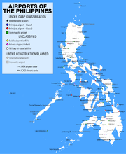
Three classes of airports exist in the Philippines under the new system of classification instituted by the Civil Aviation Authority of the Philippines (CAAP): international airports, principal airports and community airports. Only airports owned by the national government are classified by the CAAP; the vast majority of minor aerodromes around the country are not owned by the national government and remain unclassified under the new scheme.
Classification
Airports in the Philippines have used two different types of classification: one previously by the Air Transportation Office (ATO) and another being used by the Civil Aviation Authority of the Philippines (CAAP), the successor body to the ATO.ATO system

- Primary international airports are the primary international gateways into the Philippines.
- Secondary international airports are airports that are capable of handling international flights but are not designated as primary international gateways. These airports may or may not service actual international flights and may or may not have active customs and immigration facilities.
- Trunkline airports or major commercial domestic airports are domestic airports in major cities around the Philippines that are capable of supporting large aircraft. These are, in most cases, the only domestic airports with an instrument landing systemInstrument Landing SystemAn instrument landing system is a ground-based instrument approach system that provides precision guidance to an aircraft approaching and landing on a runway, using a combination of radio signals and, in many cases, high-intensity lighting arrays to enable a safe landing during instrument...
. - Secondary airports or minor commercial domestic airports are domestic airports in smaller cities and municipalities usually capable of handling smaller propeller aircraft. Some airports in this classification are capable of supporting jet aircraft. However, these airports are only open from sunrise until sunset, usually requiring notification of airport authorities if nighttime landing is a necessity.
- Feeder airports are domestic airports capable only of handling small propeller aircraft. Many of these airports are small airstrips serving far-flung islands.
CAAP system
The new CAAP system revises the previous ATO system, while maintaining the current classification of airports into international and domestic airports. The change was made pursuant to the Philippine Transport Strategic Study and the 1992 Civil Aviation Master Plan. The new system rationalizes the system of airport classification, represented by the following types:- International airports are airports capable of handling international flights. Airports in this category include airports that currently have or have previously served international destinations. There are currently ten airports in this category, including all primary international airports, most secondary international airports, and Puerto Princesa AirportPuerto Princesa AirportPuerto Princesa International Airport is an airport serving the general area of Puerto Princesa City, located in the province of Palawan in the Philippines...
and Kalibo AirportKalibo AirportKalibo International Airport is an airport that serves the general area of Kalibo, the capital of the province of Aklan in the Philippines...
, both trunkline and secondary airports, respectively. - Principal airports or domestic airports are airports that only serve domestic destinations. There are two types:
- Class 1 principal airports are airports capable of serving jet aircraft with a capacity of at least 100 seats. Most airports previously classified as trunkline airports, as well as some secondary airports, are placed in this category. Two former secondary international airports — the Bacolod-Silay Airport and the Iloilo International AirportIloilo International AirportIloilo International Airport is the airport serving the general area of Iloilo City, the capital city of the province of Iloilo and the regional center of the Western Visayas region in the Philippines...
— are also in this category. - Class 2 principal airports are airports capable of serving propeller aircraft with a capacity of at least 19 seats. Loakan AirportLoakan AirportLoakan Airport is an airport serving the general area of Baguio City, located in the province of Benguet in the Philippines...
in Baguio CityBaguio CityThe City of Baguio is a highly urbanized city in northern Luzon in the Philippines. Baguio City was established by Americans in 1900 at the site of an Ibaloi village known as Kafagway...
, previously a trunkline airport, some secondary airports, and Godofredo P. Ramos AirportGodofredo P. Ramos AirportGodofredo P. Ramos Airport , also known as Caticlan Airport, is an airport serving the general area of the town of Malay, located in the province of Aklan in the Philippines...
in MalayMalay, AklanThe Municipality of Malay is a first class municipality in the province of Aklan, Philippines. According to the 2007 census, it has a population of 32,110 people in 4,747 households....
, AklanAklanAklan is a province of the Philippines located in the Western Visayas. Its capital is Kalibo. It is located at the northwest portion of Panay Island, bordering Antique Province to the southwest, and Capiz Province to the east...
; Camiguin Airport, Cuyo AirportCuyo AirportCuyo Airport is an airport serving Cuyo, a municipality in the province of Palawan in the Philippines. It is one of three airports in Palawan, the other being Puerto Princesa Airport and Francisco Reyes Airport in the municipality of Busuanga...
and Sayak Airport in Del CarmenDel Carmen, Surigao del Norte' is a 5th class municipality within the island of Siargao, in the province of Surigao del Norte, Philippines. According to the 2000 census, it has a population of 13,558 people in 2,598 households.-Barangays:...
, Surigao del NorteSurigao del NorteSurigao del Norte is a province of the Philippines located in the Caraga region in Mindanao. Its capital is Surigao City. The province consists of two major islands—Siargao Island and Bucas Grande Island—in the Philippine Sea, and a small region at the northernmost tip of the island of...
(on Siargao IslandSiargao Islandis a tear-drop shaped island in the Philippine Sea situated 800 kilometers southeast of Manila in the province of Surigao del Norte. It has a land area of approximately 437 square kilometers. The east coast is relatively straight with one deep inlet, Port Pilar. The coastline is marked by a...
), all feeder airports, are in this category.
- Class 1 principal airports are airports capable of serving jet aircraft with a capacity of at least 100 seats. Most airports previously classified as trunkline airports, as well as some secondary airports, are placed in this category. Two former secondary international airports — the Bacolod-Silay Airport and the Iloilo International Airport
- Community airports are airports that are used primarily for general aviationGeneral aviationGeneral aviation is one of the two categories of civil aviation. It refers to all flights other than military and scheduled airline and regular cargo flights, both private and commercial. General aviation flights range from gliders and powered parachutes to large, non-scheduled cargo jet flights...
. Most feeder airports are in this category and only three airports: Cauayan AirportCauayan AirportCauayan Airport is an airport serving the general area of Cauayan City, located in Isabela province in the Philippines. It is one of three commercially airports in Isabela, the other being Palanan Airport in the town of Palanan and Maconacon Airport in the town of Maconacon...
, Labo AirportLabo Airport-External links:*...
in Ozamiz CityOzamiz CityOzamiz is a 2nd class city in the province of Misamis Occidental, Philippines. According to the 2007 census, it has a population of 123,137.- History :...
and San Fernando Airport in La UnionLa UniónLa Union or La Unión may refer to:-Colombia:*La Unión, Antioquia*La Unión, Nariño*La Unión, Sucre*La Unión, Valle del Cauca-Peru:*La Unión Province, Peru...
, all former secondary airports, have regular air service.
Some feeder airports previously classified in the old ATO system, such as Lucena Airport, are not covered by the new system. Airports not owned by the national government which were not classified in the previous ATO system, such as El Nido Airport
El Nido Airport
El Nido Airport is an airport serving El Nido, a municipality in the province of Palawan in the Philippines. Also known as Lio Airport, it is located in the barangay of Villa Libertad, about from the población of El Nido. This rolled gravel airstrip is owned and operated by the Ten Knots...
, remain unclassified under the present CAAP system.
Airports
Airport names shown in bold indicate that the airport has scheduled service on commercial airlines. Under the current ICAO code scheme, airports in the LuzonLuzon
Luzon is the largest island in the Philippines. It is located in the northernmost region of the archipelago, and is also the name for one of the three primary island groups in the country centered on the Island of Luzon...
island group (including the Cuyo Islands, but excluding Masbate
Masbate
Masbate is an island province of the Philippines located in the Bicol Region. Its capital is Masbate City and consists of three major islands: Masbate, Ticao and Burias.-History:...
and the rest of Palawan
Palawan
Palawan is an island province of the Philippines located in the MIMAROPA region or Region 4. Its capital is Puerto Princesa City, and it is the largest province in the country in terms of total area of jurisdiction. The islands of Palawan stretch from Mindoro in the northeast to Borneo in the...
) are assigned RPL- and RPU- codes; those in the Visayas
Visayas
The Visayas or Visayan Islands and locally known as Kabisay-an gid, is one of the three principal geographical divisions of the Philippines, along with Mindanao and Luzon. It consists of several islands, primarily surrounding the Visayan Sea, although the Visayas are considered the northeast...
, Masbate and Palawan (except for Cuyo), RPV- and RPS-; and those in Mindanao
Mindanao
Mindanao is the second largest and easternmost island in the Philippines. It is also the name of one of the three island groups in the country, which consists of the island of Mindanao and smaller surrounding islands. The other two are Luzon and the Visayas. The island of Mindanao is called The...
, RPM- and RPN-. Airports whose ICAO codes are in italic may be obsolete as they do not fit the current scheme.
CAAP-classified airports
The list below follows the CAAP's classification for airports in the Philippines.| City/Municipality | Province Provinces of the Philippines The Provinces of the Philippines are the primary political and administrative divisions of the Philippines. There are 80 provinces at present, further subdivided into component cities and municipalities. The National Capital Region, as well as independent cities, are autonomous from any provincial... |
IATA | ICAO International Civil Aviation Organization airport code The ICAO airport code or location indicator is a four-character alphanumeric code designating each airport around the world. These codes are defined by the International Civil Aviation Organization, and published in ICAO Document 7910: Location Indicators.The ICAO codes are used by air traffic... |
Airport name | Classification | Coordinates |
|---|---|---|---|---|---|---|
| Angeles City Angeles City The City of Angeles , located within the province of Pampanga in the Philippines, is locally classified as a first-class, highly-urbanized city. Its name is derived from El Pueblo de los Ángeles in honor of its patron saints, Los Santos Ángeles de los Custodios , and the name of its founder, Don... |
Pampanga Pampanga Pampanga is a province of the Philippines located in the Central Luzon region. Its capital is the City of San Fernando, Pampanga. Pampanga is bordered by the provinces of Bataan and Zambales to the west, Tarlac and Nueva Ecija to the north, and Bulacan to the southeast... |
CRK | RPLC ( |
Diosdado Macapagal (Clark) International Airport Diosdado Macapagal International Airport Diosdado Macapagal International Airport , also called Clark International Airport , is the main airport serving the immediate vicinity of the Clark Freeport Zone and the general area of Angeles City in the Philippines... |
International | 15°11′09"N 120°33′37"E |
| Davao City Davao City The City of Davao is the largest city in the island of Mindanao in the Philippines. Its international airport and seaports are among the busiest cargo hubs in the Philippines.... |
Davao del Sur Davao del Sur Davao del Sur is a province of the Philippines located in the Davao Region in Mindanao. Its capital is Digos City. The province is bordered by Davao City to the north, and Cotabato, Sultan Kudarat, South Cotabato, and Sarangani to the west. To the east lies the Davao Gulf... |
DVO | RPMD ( |
Francisco Bangoy (Davao) International Airport Francisco Bangoy International Airport Francisco Bangoy International Airport , also called Davao International Airport , is the main airport serving Davao City in the Philippines. It is the busiest airport in the island of Mindanao... |
International | 07°07′31"N 125°38′44"E |
| General Santos City General Santos City The City of General Santos is the southernmost port city of the Philippines. Being a highly urbanized first class city, GenSan is one of the most populous urban centers in the country with a population of 679,588 as per census data of 2010... |
South Cotabato South Cotabato South Cotabato is a province of the Philippines located in the SOCCSKSARGEN region in Mindanao. Its capital is Koronadal City, and it borders Sultan Kudarat to the north and west, Sarangani to the south and east, and Davao del Sur to the east... |
GES | RPMR | General Santos International (Tambler) Airport General Santos International Airport General Santos International Airport is an alternate international airport located in General Santos City, Philippines serving the greater area of SOCCSKSARGEN... |
International | 06°03′28"N 125°05′45"E |
| Kalibo Kalibo, Aklan Kalibo is the capital of the province of Aklan, in the northwest of Panay Island, Philippines. It is a First Class Municipality in the Western Visayas Region practically located at the center of all coastal municipalities of Aklan province... |
Aklan Aklan Aklan is a province of the Philippines located in the Western Visayas. Its capital is Kalibo. It is located at the northwest portion of Panay Island, bordering Antique Province to the southwest, and Capiz Province to the east... |
KLO | RPVK | Kalibo International Airport | International | 11°40′45"N 122°22′34"E |
| Laoag City Laoag City The City of Laoag is a 1st class city in the province of Ilocos Norte, Philippines. It is the capital city of Ilocos Norte, and the province's political, commercial, and industrial hub. It is the location of the Ilocos region's only commercial airport... |
Ilocos Norte Ilocos Norte Ilocos Norte is a province of the Philippines located in the Ilocos Region in Luzon. Its capital is Laoag City and is located at the northwest corner of Luzon Island, bordering Cagayan and Apayao to the east, and Abra and Ilocos Sur to the south... |
LAO | RPLI | Laoag International Airport Laoag International Airport Laoag International Airport is the main airport serving the general area of Laoag City, the capital city of the province of Ilocos Norte in the Philippines. It is the only airport in Ilocos Norte and is the northernmost international airport in the Philippines by geographical location... |
International | 18°10′41"N 120°31′53"E |
| Lapu-Lapu City Lapu-Lapu City The City of Lapu-Lapu is a first class highly urbanized city in the province of Cebu in the Philippines. The city occupies most of Mactan Island, a few kilometer off the main island of Cebu and also covers the Olango Island Group further to the southeast, plus a few other islets. It is part of the... |
Cebu Cebu Cebu is a province in the Philippines, consisting of Cebu Island and 167 surrounding islands. It is located to the east of Negros, to the west of Leyte and Bohol islands... |
CEB | RPVM | Mactan-Cebu International Airport Mactan-Cebu International Airport Mactan-Cebu International Airport is a major international airport in the Visayas region of the Philippines. It is located in Lapu-Lapu City, Mactan Island, Metro Cebu and is the country's second primary gateway... |
International | 10°18′48"N 123°58′58"E |
| Parañaque City Parañaque City The City of Parañaque , or simply Parañaque , is one of the cities and municipalities that make up Metro Manila in the Philippines.... /Pasay City Pasay City The City of Pasay is one of the cities and municipalities that make up Metro Manila in the Philippines. It is bordered on the north by the country's capital, Manila, to the northeast by Makati City, to the east by Taguig City, and Parañaque City to the south.Pasay City was one of the original four... |
Metro Manila Metro Manila Metropolitan Manila , the National Capital Region , or simply Metro Manila, is the metropolitan region encompassing the City of Manila and its surrounding areas in the Philippines... |
MNL | RPLL ( |
Ninoy Aquino (Manila) International Airport Ninoy Aquino International Airport The Ninoy Aquino International Airport or NAIA , also known as Manila International Airport , is the airport serving the general area of Manila and its surrounding metropolitan area... |
International | 14°30′31"N 121°01′10"E |
| Puerto Princesa City Puerto Princesa City The City of Puerto Princesa is a city located on the western provincial island of Palawan, one of 80 provinces which make up the Philippines... |
Palawan Palawan Palawan is an island province of the Philippines located in the MIMAROPA region or Region 4. Its capital is Puerto Princesa City, and it is the largest province in the country in terms of total area of jurisdiction. The islands of Palawan stretch from Mindoro in the northeast to Borneo in the... |
PPS | RPVP | Puerto Princesa International Airport | International | 09°44′31"N 118°45′31"E |
| Morong Morong, Bataan Morong is a 3rd class municipality in the province of Bataan, Philippines. According to the latest census, it has a population of 27,119 people in 4,204 households. Subic Bay International Airport is located in this town... |
Bataan Bataan Bataan is a province of the Philippines occupying the whole of the Bataan Peninsula on Luzon. The province is part of the Central Luzon region. The capital of Bataan is Balanga City and it is bordered by the provinces of Zambales and Pampanga to the north... |
SFS | RPLB ( |
Subic Bay International Airport Subic Bay International Airport -Cargo airlines:As of October 2010, there are no cargo airlines operating in Subic Bay International Airport.FedEx Express closed its hub at Subic Bay on February 6, 2009, this was the first hub to be closed in FedEx's history... |
International | 14°47′40"N 120°16′16"E |
| Zamboanga City Zamboanga City The City of Zamboanga : is a highly urbanized, independent and a chartered city located in Mindanao, Philippines.... |
Zamboanga del Sur Zamboanga del Sur Zamboanga del Sur is a province of the Philippines located in the Zamboanga Peninsula region in Mindanao. Pagadian City is the capital... |
ZAM | RPMZ | Zamboanga International Airport Zamboanga International Airport Zamboanga International Airport is the main airport serving Zamboanga City in the Philippines. The airport is Mindanao's third-busiest airport after Francisco Bangoy International Airport in Davao City and Lumbia Airport in Cagayan de Oro City... |
International | 06°55′20"N 122°03′34"E |
| Silay City Silay City Silay City is a 2nd class city in the province of Negros Occidental, Philippines. According to the August 1, 2007 census, it had a total population of 120,365 people... |
Negros Occidental Negros Occidental Negros Occidental is a province of the Philippines located in the Western Visayas region. Its capital is Bacolod City and it occupies the northwestern half of Negros Island; Negros Oriental is at the southeastern half... |
BCD | RPVB | Bacolod-Silay Airport | Principal-Class 1 | 10°46′35"N 123°00′55"E |
| Butuan City Butuan City The City of Butuan is the regional center of Caraga, serving as an administrative region of the Philippines; it is a highly urbanized city. It is located at the northeastern part of Agusan Valley, Mindanao, sprawling across the Agusan River. It is bounded to the north, west and south by Agusan del... |
Agusan del Sur Agusan del Sur Agusan del Sur is a landlocked province of the Philippines located in the Caraga region in Mindanao. Its capital is Prosperidad and borders, from the north clockwise, Agusan del Norte, Surigao del Sur, Davao Oriental, Compostela Valley, Davao del Norte, Bukidnon, and Misamis... |
BXU | RPME ( |
Bancasi (Butuan) Airport Bancasi Airport Bancasi Airport , also known as Butuan Airport, is an airport serving the general area of Butuan City, located in the province of Agusan del Norte in the Philippines. It is the only airport in the province and largest in the Caraga region... |
Principal-Class 1 | 08°57′04"N 125°28′40"E |
| Cagayan de Oro City Cagayan de Oro City Cagayan de Oro; , officially the City of Cagayan de Oro, is the provincial capital city of the province of Misamis Oriental in the Philippines... |
Misamis Oriental Misamis Oriental Misamis Oriental is a province of the Philippines located in the Northern Mindanao region. Its capital and provincial center is Cagayan de Oro City... |
CGY | RPML ( |
Lumbia (Cagayan de Oro) Airport Lumbia Airport - See also :* Misamis Oriental* Laguindingan International Airport, the first International airport in Northern Mindanao region.* List of airports in the Philippines* Northern Mindanao, designated as Region X in the Philippines.... |
Principal-Class 1 | 08°24′56"N 124°36′40"E |
| Cotabato City Cotabato City The City of Cotabato is one of the cities of the Philippines located in Mindanao. Cotabato City is an exclave of the SOCCSKSARGEN region found within the boundaries of Maguindanao province, but is independent of that province... |
Maguindanao Maguindanao Maguindanao is a province of the Philippines located in the Autonomous Region in Muslim Mindanao . Its capital is Shariff Aguak. It borders Lanao del Sur to the north, Cotabato to the east, and Sultan Kudarat to the south.... |
CBO | RPMC ( |
Awang (Cotabato) Airport Awang Airport Awang Airport is an airport serving the general area of Cotabato City, located in the province of Maguindanao in the Philippines... |
Principal-Class 1 | 07°09′54"N 124°12′34"E |
| Dipolog City Dipolog City The City of Dipolog is a 1st class city and the capital of the province of Zamboanga del Norte on the southern Philippine island of Mindanao... |
Zamboanga del Norte Zamboanga del Norte Zamboanga del Norte or simply known as ZANORTE is a province of the Philippines located in the Zamboanga Peninsula region in Mindanao. Its capital is Dipolog City and the province borders Zamboanga del Sur and Zamboanga Sibugay to the south and Misamis Occidental to the east... |
DPL | RPMG ( |
Dipolog Airport Dipolog Airport Dipolog Airport is the main airport serving the general area of Dipolog City, the capital of Zamboanga del Norte, in the Philippines. The airport is one of the busiest in Mindanao, especially considering its classification... |
Principal-Class 1 | 08°36′06"N 123°20′33"E |
| Sibulan Sibulan, Negros Oriental Sibulan is a 4th class municipality in the province of Negros Oriental, Philippines. According to the 2000 census, it has a population of 47,162 people in 7,871 households.Sibulan is bordered to the south by Dumaguete City, the provincial capital... |
Negros Oriental Negros Oriental Negros Oriental is a province of the Philippines located in the Central Visayas region. It occupies the south-eastern half of the island of Negros, with Negros Occidental comprising the north-western half. It also includes Apo Island — a popular dive site for both local and foreign tourists... |
DGT | RPVD | Sibulan (Dumaguete) Airport Sibulan Airport Sibulan Airport , also known as Dumaguete Airport, is an airport serving the general area of Dumaguete City, located in the province of Negros Oriental in the Philippines... |
Principal-Class 1 | 09°20′01"N 123°18′02"E |
| Cabatuan Cabatuan, Iloilo Cabatuan is a 3rd class municipality in the province of Iloilo, Philippines. According to the 2007 census by the National Statistics Office of the Philippines, it has a population of 50,861 people. It is described as a cultural and religious town in the heart of Panay Island and is about 24... |
Iloilo | ILO | RPVI | Iloilo International (New Iloilo) Airport Iloilo International Airport Iloilo International Airport is the airport serving the general area of Iloilo City, the capital city of the province of Iloilo and the regional center of the Western Visayas region in the Philippines... |
Principal-Class 1 | 10°49′56"N 122°29′35"E |
| Legazpi City Legazpi City The City of Legazpi is a first class city and capital of the province of Albay, Philippines. With 179,481 inhabitants according to the 2007 census, it is the largest city in the Bicol Region in terms of population, though not in land area... |
Albay Albay Albay is a province of the Philippines located in the Bicol Region in Luzon. Its capital is Legazpi City and the province borders Camarines Sur to the north and Sorsogon to the south. Also to the northeast is Lagonoy Gulf.... |
LGP | RPLP | Legazpi Airport Legazpi Airport Legazpi Airport in the Philippines is a major airport in the Bicol Region, serving the vicinity of Legazpi City in Albay... |
Principal-Class 1 | 13°09′09"N 123°43′48"E |
| Pili Pili, Camarines Sur Pili is a 1st class municipality in the province of Camarines Sur, Philippines. It is the capital municipality of Camarines Sur. According to the 2007 census, it has a population of 76,496 people.-History:... |
Camarines Sur Camarines Sur Camarines Sur is a province of the Philippines located in the Bicol Region in Luzon. Its capital is Pili and the province borders Camarines Norte and Quezon to the north, and Albay to the south... |
WNP | RPUN | Naga (Pili) Airport Naga Airport Naga Airport is an airport serving the general area of Naga City, located in the province of Camarines Sur in the Philippines, as well as the city's metropolitan area... |
Principal-Class 1 | 13°35′05"N 123°16′12"E |
| Pagadian City Pagadian City The City of Pagadian is the provincial capital of Zamboanga del Sur in the island of Mindanao, Republic of the Philippines.-Overview:The city had its beginnings as a... |
Zamboanga del Sur Zamboanga del Sur Zamboanga del Sur is a province of the Philippines located in the Zamboanga Peninsula region in Mindanao. Pagadian City is the capital... |
PAG | RPMP ( |
Pagadian Airport Pagadian Airport Pagadian Airport is an airport serving the general area of Pagadian City, the capital of Zamboanga del Sur, and neighboring municipalities and provinces such as Zamboanga Sibugay in the Philippines... |
Principal-Class 1 | 07°49′38"N 123°27′30"E |
| Roxas City Roxas City Roxas City is a medium-sized city in the province of Capiz, Philippines. It is the provincial capital and a component city. , the city mayor is former city vice mayor Angel Alan Celino who was elected during the 2010 election.... |
Capiz Capiz Capiz is a province of the Philippines located in the Western Visayas region. Its capital is Roxas City and is located at the northeastern portion of Panay Island, bordering Aklan and Antique to the west, and Iloilo to the south. Capiz faces the Sibuyan Sea to the north... |
RXS | RPVR | Roxas Airport Roxas Airport -External links:*... |
Principal-Class 1 | 11°35′51"N 122°45′06"E |
| San Jose San Jose, Occidental Mindoro San Jose is a 1st class municipality in the province of Occidental Mindoro, Philippines. According to the 2000 census, it has a population of 111,009 people in 22,464 households. According to the 2007 census, the population increased to 118,807 people.... |
Occidental Mindoro Occidental Mindoro Occidental Mindoro is a province of the Philippines located in the MIMAROPA region in Luzon. "Home of the Indigenous Mangyans". Its capital is Mamburao and occupies the western half of the island of Mindoro, on the west by Apo East Pass, and on the south by the Mindoro Strait; Oriental Mindoro is... |
SJI | RPUH | San Jose Airport | Principal-Class 1 | 12°21′41"N 121°02′48"E |
| Tacloban City Tacloban City The City of Tacloban is a port city approximately 360 miles southeast of Manila. It is the first in Eastern Visayas to be classified as a Highly Urbanized City. It is the capital of the Philippine province of Leyte and is the largest city in terms of population in Eastern Visayas... |
Leyte Leyte Leyte is a province of the Philippines located in the Eastern Visayas region. Its capital is Tacloban City and occupies the northern three-quarters of the Leyte Island. Leyte is located west of Samar Island, north of Southern Leyte and south of Biliran... |
TAC | RPVA | Daniel Z. Romualdez (Tacloban) Airport Daniel Z. Romualdez Airport -Facilities:Daniel Z. Romualdez Airport's facilities include a single-storey terminal building, a communications tower and administrative building. Small cafes surround outside the terminal across the parking area.* Terminal... |
Principal-Class 1 | 11°13′39"N 125°01′40"E |
| Tagbilaran City Tagbilaran City Tagbilaran City is a 2nd class component city in the island province of Bohol, Philippines and serves as its capital. Tagbilaran lies on the southwestern part of the province, and has a total land area of 32.7 km², with about 13 km of coastline... |
Bohol Bohol Bohol is an island province of the Philippines located in the Central Visayas region, consisting of Bohol Island and 75 minor surrounding islands. Its capital is Tagbilaran City. With a land area of and a coastline long, Bohol is the tenth largest island of the Philippines... |
TAG | RPVT | Tagbilaran Airport Tagbilaran Airport Tagbilaran Airport is an airport serving the general area of Tagbilaran City, located in the province of Bohol in the Philippines... |
Principal-Class 1 | 09°39′50"N 123°51′11"E |
| Tuguegarao City Tuguegarao City Tuguegarao City is the city capital of Cagayan, Philippines and the regional capital of Region 02 . Tuguegarao is the economic center of the Cagayan Valley Region; it is located on a peninsula in the Cagayan Valley. It is sheltered by the Sierra Madre Mountains in the East; Cordilleras in the... |
Cagayan | TUG | RPUT | Tuguegarao Airport Tuguegarao Airport Tuguegarao Airport is an airport serving the general area of Tuguegarao City, located in the province of Cagayan in the Philippines... |
Principal-Class 1 | 17°38′36"N 121°44′00"E |
| San Jose de Buenavista San Jose, Antique San Jose is a 2nd class municipality in the province of Antique, Philippines. It is the capital municipality of Antique... |
Antique | EUQ | RPVS | Evelio Javier (Antique) Airport Evelio Javier Airport Evelio Javier Airport , also known as Antique Airport and San Jose Airport, is the only airport serving the province of Antique in the Philippines... |
Principal-Class 2 | 10°45′57"N 121°56′00"E |
| Baguio City Baguio City The City of Baguio is a highly urbanized city in northern Luzon in the Philippines. Baguio City was established by Americans in 1900 at the site of an Ibaloi village known as Kafagway... |
Benguet Benguet Benguet is a landlocked province of the Philippines in the Cordillera Administrative Region in Luzon. Its capital is La Trinidad and borders, clockwise from the south, Pangasinan, La Union, Ilocos Sur, Mountain Province, Ifugao, and Nueva Vizcaya.... |
BAG | RPUB | Loakan (Baguio) Airport Loakan Airport Loakan Airport is an airport serving the general area of Baguio City, located in the province of Benguet in the Philippines... |
Principal-Class 2 | 16°22′30"N 120°37′10"E |
| Basco Basco, Batanes Basco is a 5th class municipality in the Batanes Province, Philippines. It is the capital municipality of Batanes... (Batan Island Batan Island Batan island is the main island of the Batanes Province in the Philippines, part of the Batanes Islands group and the Luzon Volcanic Arc. It is home to the provincial capital Basco. The island is known chiefly for Mount Iraya.... ) |
Batanes Batanes The Province of Batanes , also called the Batanes Islands, is a Philippine province comprising ten islands that are located in the Luzon Strait between the islands of Luzon and Taiwan... |
BSO | RPUO | Basco Airport Basco Airport Basco Airport is an airport serving the province of Batanes in the Philippines. It is located in the provincial capital, Basco, and is one of two airports in the Batanes Islands, the other being Itbayat Airport... |
Principal-Class 2 | 20°27′05"N 121°58′47"E |
| Bongao Bongao, Tawi-Tawi Bongao is a 3rd class municipality in the province of Tawi-Tawi, Philippines. According to the 2000 census, it has a population of 58,174 people in 10,146 households.-History:... |
Tawi-Tawi Tawi-Tawi Tawi-Tawi is an island province of the Philippines located in the Autonomous Region in Muslim Mindanao . The capital of Tawi-Tawi is Bongao. The province is the southernmost of the country sharing sea borders with the Malaysian State of Sabah and the Indonesian East Kalimantan province. To the... |
SGS (TWT) | RPMN ( |
Sanga-Sanga (Tawi-Tawi) Airport Sanga-Sanga Airport Sanga-Sanga Airport , also known as Tawi-Tawi Airport, is an airport serving the general area of Bongao, the capital of the province of Tawi-Tawi in the Philippines... |
Principal-Class 2 | 05°02′49"N 119°44′34"E |
| Coron Coron, Palawan Coron is a first class municipality in the province of Palawan, Philippines. According to the 2000 census, it had a population of 32,243 people in 6,264 households.... (Busuanga Island Busuanga Island Busuanga Island is the largest island in the Calamian Group in the province of Palawan in the Philippines. Busuanga Island is, in fact, the second largest island in the province after Palawan island itself. The island is located halfway between the islands of Mindoro and Palawan with the South... ) |
Palawan Palawan Palawan is an island province of the Philippines located in the MIMAROPA region or Region 4. Its capital is Puerto Princesa City, and it is the largest province in the country in terms of total area of jurisdiction. The islands of Palawan stretch from Mindoro in the northeast to Borneo in the... |
USU | RPVV | Francisco B. Reyes (Busuanga-Coron) Airport | Principal-Class 2 | 12°07′17"N 120°06′00"E |
| Calbayog City Calbayog City Calbayog City is a first class city in the province of Samar, Philippines. It lies along the coastal region of the province stretching about from the northern tip of the island and from southern boundaries... |
Samar | CYP | RPVC | Calbayog Airport Calbayog Airport Calbayog Airport is an airport serving the general area of Calbayog City, located in the province of Samar in the Philippines... |
Principal-Class 2 | 12°04′22"N 124°32′42"E |
| Mambajao Mambajao, Camiguin Mambajao is a 3rd class municipality in the province of Camiguin, Philippines. It is the capital municipality of Camiguin. According to the 2000 census, it has a population of 30,806 people in 5,978 households.-History:... |
Camiguin Camiguin Camiguin is an island province of the Philippines located in the Bohol Sea, about off the northern coast of Misamis Oriental in Mindanao. It is the second-smallest province both in population and land area after Batanes... |
CGM | RPMH | Camiguin Airport | Principal-Class 2 | 09°15′12"N 124°42′25"E |
| Catarman Catarman, Northern Samar Catarman is a first class Municipality in the Philippines. It is the capital and largest town in terms of both land area and population in the province of Northern Samar. According to the 2007 census, it has a population of 81,067 making it the most populous municipality in Eastern Visayas... |
Northern Samar Northern Samar Northern Samar is a province of the Philippines located in the Eastern Visayas region. Its capital is Catarman and is located at the northern portion of the island of Samar. Bordering the province to the south are the provinces of Samar and Eastern Samar... |
CRM | RPVF | Catarman National Airport Catarman National Airport Catarman National Airport , otherwise known as Catarman Airport, is an airport serving the general area of Catarman, located in the province of Northern Samar in the Philippines... |
Principal-Class 2 | 12°30′09"N 124°38′09"E |
| Malay Malay, Aklan The Municipality of Malay is a first class municipality in the province of Aklan, Philippines. According to the 2007 census, it has a population of 32,110 people in 4,747 households.... (Boracay Boracay Boracay is an island of the Philippines located approximately south of Manila and 2 km off the northwest tip of Panay Island in the Western Visayas region of the Philippines. Boracay Island and its beaches have received awards numerous times. Boracay was awarded in the "Travelers' Choice... ) |
Aklan Aklan Aklan is a province of the Philippines located in the Western Visayas. Its capital is Kalibo. It is located at the northwest portion of Panay Island, bordering Antique Province to the southwest, and Capiz Province to the east... |
MPH | RPVE | Godofredo P. Ramos (Caticlan) Airport Godofredo P. Ramos Airport Godofredo P. Ramos Airport , also known as Caticlan Airport, is an airport serving the general area of the town of Malay, located in the province of Aklan in the Philippines... |
Principal-Class 2 | 11°55′29"N 121°57′18"E |
| Magsaysay Magsaysay, Palawan Magsaysay is a 5th class municipality in the province of Palawan, Philippines. According to the 2000 census, it has a population of 10,885 people in 2,269 households... (Cuyo Island) |
Palawan Palawan Palawan is an island province of the Philippines located in the MIMAROPA region or Region 4. Its capital is Puerto Princesa City, and it is the largest province in the country in terms of total area of jurisdiction. The islands of Palawan stretch from Mindoro in the northeast to Borneo in the... |
CYU | RPLO ( |
Cuyo Airport Cuyo Airport Cuyo Airport is an airport serving Cuyo, a municipality in the province of Palawan in the Philippines. It is one of three airports in Palawan, the other being Puerto Princesa Airport and Francisco Reyes Airport in the municipality of Busuanga... |
Principal-Class 2 | 10°51′29"N 121°04′10"E |
| Jolo Jolo, Sulu Jolo is a municipality on the island of Jolo, and the capital and largest town of the province of Sulu. According to the 2000 census, it has a population of 87,998 people in 12,814 households. Part of its population is of Chinese descent, mainly from Singapore... |
Sulu | JOL | RPMJ ( |
Jolo Airport Jolo Airport Jolo Airport is the airport serving the general area of Jolo, located in the province of Sulu in the Philippines. It is the only airport in the province of Sulu... |
Principal-Class 2 | 06°03′13"N 121°00′40"E |
| Gasan Gasan, Marinduque Gasan is a 3rd class municipality in the province of Marinduque, Philippines. According to the 2007 census, it has a population of 33,772 people. The municipality is bounded by the provincial capital, Boac, to the north and east, by Buenavista to the southeast and by the Tablas Strait to the south... |
Marinduque Marinduque In 1945, combined American and Philippine Commonwealth troops attacked from the Japanese Troops liberated to the Battle of Marinduque in the Second World War.-Archaeology:... |
MRQ | RPUW | Marinduque Airport Marinduque Airport Marinduque Airport is the only airport located on and serving the island province of Marinduque in the Philippines. The airport is located in Barangay Masiga in the town of Gasan, near the border with the provincial capital, Boac... |
Principal-Class 2 | 13°21′36"N 121°49′31"E |
| Masbate City Masbate City The City of Masbate is a 4th class city in the province of Masbate, Philippines. It is the capital city of Masbate province... |
Masbate | MBT | RPVJ | Moises R. Espinosa (Masbate) Airport | Principal-Class 2 | 12°22′10"N 123°37′45"E |
| Ormoc City Ormoc City The City of Ormoc is a 1st class city in the province of Leyte, Philippines. The city's name is derived from ogmok, an old Visayan term for lowland or depressed plain. It is the first non-provincial city of the Philippines. According to the 2007 census, it has a population of 177,524 people... |
Leyte Leyte Leyte is a province of the Philippines located in the Eastern Visayas region. Its capital is Tacloban City and occupies the northern three-quarters of the Leyte Island. Leyte is located west of Samar Island, north of Southern Leyte and south of Biliran... |
OMC | RPVO | Ormoc Airport Ormoc Airport Ormoc Airport is an airport serving the general area of Ormoc City, located in the province of Leyte in the Philippines. It is one of three airports in the province of Leyte, the others being Daniel Z. Romualdez Airport in Tacloban City and Hilongos Airport... |
Principal-Class 2 | 11°03′22"N 124°33′56"E |
| Alcantara Alcantara, Romblon Alcantara is a fifth class municipality in the province of Romblon, Philippines. According to the 2000 census, it has a population of 14,144 people in 2,905 households.-Barangays:Alcantara is politically subdivided into 12 barangays:* Bonlao* Calagonsao... (Tablas Island Tablas Island Tablas is the largest of the islands that comprise the province of Romblon in the Philippines.Odiongan, on the west central coast of the island, is a major port and the largest municipality of Romblon in terms of population... ) |
Romblon | TBH | RPVU | Tugdan (Romblon) Airport Tugdan Airport Tugdan Airport is an airport located in the province of Romblon in the Philippines... |
Principal-Class 2 | 12°18′39"N 122°04′46"E |
| Del Carmen Del Carmen, Surigao del Norte ' is a 5th class municipality within the island of Siargao, in the province of Surigao del Norte, Philippines. According to the 2000 census, it has a population of 13,558 people in 2,598 households.-Barangays:... (Siargao Island Siargao Island is a tear-drop shaped island in the Philippine Sea situated 800 kilometers southeast of Manila in the province of Surigao del Norte. It has a land area of approximately 437 square kilometers. The east coast is relatively straight with one deep inlet, Port Pilar. The coastline is marked by a... ) |
Surigao del Norte Surigao del Norte Surigao del Norte is a province of the Philippines located in the Caraga region in Mindanao. Its capital is Surigao City. The province consists of two major islands—Siargao Island and Bucas Grande Island—in the Philippine Sea, and a small region at the northernmost tip of the island of... |
IAO (SOS) | RPNS ( |
Sayak (Siargao) Airport | Principal-Class 2 | 09°51′33"N 126°00′55"E |
| Surigao City Surigao City The City of Surigao The City of Surigao The City of Surigao (Filipino Pronunciation: (sů-rēh-GAŮ) ( Filipino: Lungsod ng Surigao; Surigaonon: Siyudad nan Surigao) located at the northeasternmost tip of Mindanao Island in the Philippines and the capital of the province of Surigao del Norte,... |
Surigao del Norte Surigao del Norte Surigao del Norte is a province of the Philippines located in the Caraga region in Mindanao. Its capital is Surigao City. The province consists of two major islands—Siargao Island and Bucas Grande Island—in the Philippine Sea, and a small region at the northernmost tip of the island of... |
SUG | RPMS ( |
Surigao Airport Surigao Airport Surigao Airport is an airport serving the general area of Surigao City, located in the province of Surigao del Norte in the Philippines... |
Principal-Class 2 | 09°45′28"N 125°28′51"E |
| Tandag Tandag, Surigao del Sur Tandag is a and the provincial capital of the province of Surigao del Sur, Philippines. According to the 2000 census, it has a population of 44,327 people in 8,449 households.-Barangays:Tandag is politically subdivided into 21 barangays.... |
Surigao del Sur Surigao del Sur ' is a province of the Philippines located in the CARAGA region in Mindanao. Its capital is Tandag City and borders Surigao del Norte to the north, Agusan del Norte and Agusan del Sur to the west, and Davao Oriental to the south... |
TDG | RPMW ( |
Tandag Airport Tandag Airport Tandag Airport is the airport serving the general area of Tandag, the capital city of Surigao del Sur in the Philippines. It is one of two airports in Surigao del Sur, the other being Bislig Airport... |
Principal-Class 2 | 09°04′20"N 126°10′17"E |
| Virac Virac, Catanduanes Virac is a 1st class municipality in the province of Catanduanes, Philippines. It is the capital municipality of the province and the third largest town with a land area of 188 km2... |
Catanduanes Catanduanes Catanduanes is an island province of the Philippines located in the Bicol Region in Luzon. Its capital is Virac and the province lies to the east of Camarines Sur across Maqueda Channel. As of 2007, the population of the province is 232,757 people.-Etymology:"Isla de Cobos" was Catanduanes' first... |
VRC | RPUV | Virac Airport Virac Airport Virac Airport is the only airport serving the island province of Catanduanes in the Philippines. It is located in the capital, Virac... |
Principal-Class 2 | 13°34′35"N 124°12′20"E |
| Perez Perez, Quezon Perez is a 5th class municipality in the province of Quezon, Philippines. According to the 2007 census, it has a population of 11,022 people.-Name:... (Alabat Island Alabat Island Alabat Island is an island of the Philippine archipelago, in the Quezon Province of the CALABARZON region, situated just off the East coast of Southern Luzon... ) |
Quezon Quezon -History:Originally, what now forms Quezon was divided among the provinces of Batangas, Laguna, and Nueva Ecija. The area was first explored by Juan de Salcedo in 1571-1572, during his expedition from Laguna to Camarines provinces.... |
RPLY ( |
Alabat Airport | Community | 14°13′57"N 121°55′44"E | |
| Surallah Surallah, South Cotabato Surallah is an agro-industrial municipality in the province of South Cotabato, Philippines. According to the 2007 census, it has a population of 71,513 people in 13,634 households, thus making it the 3rd most populous municipality in the province... |
South Cotabato South Cotabato South Cotabato is a province of the Philippines located in the SOCCSKSARGEN region in Mindanao. Its capital is Koronadal City, and it borders Sultan Kudarat to the north and west, Sarangani to the south and east, and Davao del Sur to the east... |
AAV | RPMA ( |
Allah Valley Airport Allah Valley Airport Allah Valley Airport or Alah Valley Airport is an airport serving the general area of Surallah, located in South Cotabato in the Philippines. It is located within the Alah Valley, home to Lake Sebu... |
Community | 06°22′04"N 124°45′09"E |
| Bagabag Bagabag, Nueva Vizcaya Bagabag is a 3rd class municipality in the province of Nueva Vizcaya, Philippines. According to the 2007 latest Philippine census, it has 32,787 population.... |
Nueva Vizcaya Nueva Vizcaya Nueva Vizcaya is a province of the Philippines located in the Cagayan Valley region in Luzon. Its capital is Bayombong. It is bordered by, clockwise from the north, Ifugao, Isabela, Quirino, Aurora, Nueva Ecija, Pangasinan, and Benguet.-History, people and culture:The name was derived from the... |
RPUZ | Bagabag Airport Bagabag Airport Bagabag Airport is an airport serving the general area of the town of Bagabag, located in Nueva Vizcaya in the Philippines. The airport is the only airport in Nueva Vizcaya and is classified as a secondary airport by the Air Transportation Office, a body of the Department of Transportation and... |
Community | 16°37′09"N 121°15′08"E | |
| San Luis San Luis, Aurora San Luis is a 2nd class municipality in the province of Aurora, Philippines. The town is almost the same size as Metro Manila. According to the latest census, it has a population of 23,766 people in 4,548 households.-Barangays:... |
Aurora | BQA | RPUR | Dr. Juan C. Angara (Baler) Airport | Community | 15°43′49"N 121°30′06"E |
| Santa Fe Santa Fe, Cebu Santa Fe is a 5th class municipality in the province of Cebu, Philippines. According to the 2007 census, it has a population of 26,826 people. The municipality's territory includes the eastern portion of Bantayan Island , as well as Guintacan and Hilantagaan Islands.Bantayan Airport, serving... (Bantayan Island Bantayan Island Bantayan Island is in the Visayan Sea, Philippines, located just west off the northern tip of Cebu Island. The island, politically a part of the Province of Cebu, is about wide by long, with a total population of 120,101, as of the 2000 census. It is also the main and largest island of the... ) |
Cebu Cebu Cebu is a province in the Philippines, consisting of Cebu Island and 167 surrounding islands. It is located to the east of Negros, to the west of Leyte and Bohol islands... |
RPSB | Bantayan Airport Bantayan Airport Bantayan Airport is an airport serving Bantayan Island in the Province of Cebu in the Philippines. The airport is located in the municipality of Santa Fe... |
Community | 11°09′43"N 123°47′06"E | |
| Naval Naval, Biliran Naval is a 2nd class municipality in the province of Biliran, Philippines. It is the capital municipality of Biliran. According to the 2007 census, it has a population of 44,288 people in 9,575 households.... |
Biliran Biliran In 1945 liberated by the Philippine Commonwealth forces of the 9th Infantry Division of the Philippine Commonwealth Army was landed in Biliran with the local guerrilla forces by the attack of the Japanese troops from the island during the Battle of Biliran during World War II.-Conversion:On April... |
RPVQ ( |
Biliran Airport Biliran Airport Biliran Airport is an airport located in Naval, the capital of the province of Biliran, Philippines. No airline flies to this community airport.Air travel to the province of Biliran is via Tacloban City, in Leyte thru Daniel Z. Romualdez Airport.... |
Community | 11°30′55"N 124°25′47"E | |
| Bislig City Bislig City Bislig City is a 3rd class city in the province of Surigao del Sur, Mindanao, Philippines. Bislig is approximately 208 kilometers northeast of Davao City, 152 kilometers south of Tandag City and 158 southeast of Butuan City... |
Surigao del Sur Surigao del Sur ' is a province of the Philippines located in the CARAGA region in Mindanao. Its capital is Tandag City and borders Surigao del Norte to the north, Agusan del Norte and Agusan del Sur to the west, and Davao Oriental to the south... |
BPH | RPMF ( |
Bislig Airport Bislig Airport Bislig Airport is an airport serving the general area of Bislig City, located in the province of Surigao del Sur on Mindanao island in the Philippines... |
Community | 08°11′44"N 126°19′17"E |
| Borongan Borongan, Eastern Samar The City of Borongan is a component city and the provincial capital of the province of Eastern Samar, Philippines. It is bounded on the north by the municipality of San Julian, in the south by the municipality of Maydolong, in the west by the Samar municipalities of Hinabangan, Calbiga, Pinabacdao... |
Eastern Samar Eastern Samar Eastern Samar is a province of the Philippines located in the Eastern Visayas region. Its capital is the city of Borongan.-Location:... |
BPR | RPVW | Borongan (Punta Maria) Airport Borongan Airport Borongan City Airport is an airport serving the general area of Borongan, the capital of the province of Eastern Samar in the Philippines. It is one of two airports in Eastern Samar, the other being Guiuan Airport... |
Community | 11°40′27"N 125°28′43"E |
| Bulan Bulan, Sorsogon Bulan is a 1st class municipality in Sorsogon Province, Philippines. According to the 2007 census, it has a population 91,730 inhabitants.-Geography:... |
Sorsogon Sorsogon Sorsogon is a province of the Philippines located in the Bicol Region; it is the southernmost province in Luzon and is subdivided into fourteen municipalities and one city. Its capital is Sorsogon City and borders the province of Albay to the north... |
RPUU | Bulan Airport | Community | 12°41′02"N 123°52′38"E | |
| Calapan City Calapan City Calapan City is a 3rd class city in the province of Oriental Mindoro, Philippines. It is the capital city of Oriental Mindoro and known as the "Gateway to the Golden Isle". According to the 2007 census, it has a population of 116,976 people in 20,929 households.The city's economy is dependent on... |
Oriental Mindoro Oriental Mindoro Oriental Mindoro is a province of the Philippines located in the island of Mindoro under MIMAROPA region in Luzon, about 140 km southwest of Manila... |
CPP | RPUK | Calapan Airport | Community | 13°25′23"N 121°12′06"E |
| Mapun Mapun, Tawi-Tawi Mapun is a 4th class remote municipality in the province of Tawi-Tawi, Philippines. According to the 2000 census, it has a population of 22,011 people in 3,492 households.... |
Tawi-Tawi Tawi-Tawi Tawi-Tawi is an island province of the Philippines located in the Autonomous Region in Muslim Mindanao . The capital of Tawi-Tawi is Bongao. The province is the southernmost of the country sharing sea borders with the Malaysian State of Sabah and the Indonesian East Kalimantan province. To the... |
CDY | RPMU | Cagayan de Tawi-Tawi (Mapun) Airport | Community | 07°00′48"N 118°29′46"E |
| Catbalogan | Samar | RPVY ( |
Catbalogan Airport Catbalogan Airport Catbalogan Airport is an airport located in Catbalogan City, Samar, Philippines. It is classified as a feeder airport by the Air Transportation Office, a body of the Department of Transportation and Communications that is responsible for the operations of not only this airport but also of all... |
Community | 11°48′36"N 124°49′48"E | |
| Cauayan City Cauayan City Cauayan City is a 1st class city in the province of Isabela, Philippines. Cauayan City is the Agro-Industrial Capital of Cagayan Valley and The Commercial Center of The Province of Isabela... |
Isabela | CYZ | RPUY | Cauayan Airport Cauayan Airport Cauayan Airport is an airport serving the general area of Cauayan City, located in Isabela province in the Philippines. It is one of three commercially airports in Isabela, the other being Palanan Airport in the town of Palanan and Maconacon Airport in the town of Maconacon... |
Community | 16°55′47"N 121°45′11"E |
| Daet Daet, Camarines Norte Daet, also known as the "Gateway to Bicolandia". A 1st class municipality in the province of Camarines Norte, Philippines. It is the capital municipality of Camarines Norte. According to the 2007 census, it has a population of 94,184 or 18.33% of Camarines Norte's population. The current mayor of... |
Camarines Norte Camarines Norte Camarines Norte is a province of the Philippines located in the Bicol Region in Luzon. Its capital is Daet and the province borders Quezon to the west and Camarines Sur to the south.-Demographics:... |
DTE | RPUD | Bagasbas (Daet) Airport Bagasbas Airport Bagasbas Airport , also known as Daet Airport, is an airport serving the general area of the town of Daet, located in the province of Camarines Norte in the Philippines. It is the only airport in Camarines Norte... |
Community | 14°07′46"N 122°58′50"E |
| Guiuan Guiuan, Eastern Samar Guiuan is a 2nd class municipality in the province of Eastern Samar, Philippines. As of year 2004, it has a population of 43,647 people in 7,618 households.... |
Eastern Samar Eastern Samar Eastern Samar is a province of the Philippines located in the Eastern Visayas region. Its capital is the city of Borongan.-Location:... |
RPVG | Guiuan Airport Guiuan Airport Guiuan Airport is an airport located in the municipality of Guiuan, in the province of Eastern Samar in the Philippines... |
Community | 11°02′07"N 125°44′29"E | |
| Hilongos Hilongos, Leyte Hilongos is a 2nd class municipality in the province of Leyte, Philippines. It borders with the municipality of Bato in the south. According to the 2007 census, it has a population of 53,911 people in 10,763 households. Land area : 19,292... |
Leyte | RPVH | Hilongos Airport Hilongos Airport Hilongos Airport is one the three airports in the province of Leyte located in the municipality of Hilongos. It is located in the southern side of Leyte Island.There are no airlines operating on this airport.... |
Community | 10°22′36"N 124°45′40"E | |
| Iba Iba, Zambales Iba is a 2nd class municipality in the province of Zambales, Philippines. It is the capital municipality of Zambales. According to the latest census, it has a population of 44,344 people in 7,260 households.... |
Zambales Zambales Zambales is a province of the Philippines located in the Central Luzon region. Its capital is Iba. Zambales borders Pangasinan to the north, Tarlac and Pampanga to the east, and Bataan to the south. The province lies between the South China Sea and the Zambales Mountains. With a land area of... |
RPUI | Iba Airport Iba Airport Iba Airport is an airport serving the general area of Iba, located in the province of Zambales in the Philippines. It is one of the five airports in Zambales... |
Community | 15°19′33"N 119°58′06"E | |
| Baloi Baloi, Lanao del Norte Baloi is a 3rd class municipality in the province of Lanao del Norte, Philippines. According to the 2007 census, it has a population of 44,366 people.... |
Lanao del Norte Lanao del Norte Lanao del Norte is a province of the Philippines located in the Northern Mindanao region. Its capital is Tubod. The province borders Lanao del Sur to the southeast, Zamboanga del Sur to the west, Illana Bay to the southwest, Iligan Bay to the north, Iligan City to the northeast, and is separated... |
IGN | RPMI ( |
Maria Cristina (Iligan) Airport Maria Cristina Airport Maria Cristina Airport , also known as Iligan Airport, is an airport serving the general area of Iligan City, located in the province of Lanao del Norte in the Philippines. It is the only airport in the province... |
Community | 08°07′50"N 124°12′53"E |
| Ipil Ipil, Zamboanga Sibugay Ipil is a 1st class municipality in the province of Zamboanga Sibugay, Philippines. It is the capital municipality of Zamboanga Sibugay... |
Zamboanga Sibugay Zamboanga Sibugay Zamboanga Sibugay is a province of the Philippines located in the Zamboanga Peninsula region in Mindanao. Its capital is Ipil and it borders Zamboanga del Norte to the north, Zamboanga del Sur to the east and Zamboanga City to the southwest. To the south lies Sibuguey Bay in the Moro Gulf... |
IPE | RPMV | Ipil Airport Ipil Airport Ipil Airport is an airport serving the general area of Ipil, the capital of the province of Zamboanga Sibugay in the Philippines. It is the only airport in the province... |
Community | 07°47′10"N 122°36′04"E |
| Itbayat Itbayat, Batanes Itbayat is a 5th class municipality in the province of Batanes, Philippines. According to the latest census, it has a population of 3,069 people in 719 households.... (Itbayat Island Itbayat Island Itbayat is one of the Batanes Islands of the Philippines. Together with some other islands it forms the municipality of Itbayat in Batanes Province.... ) |
Batanes Batanes The Province of Batanes , also called the Batanes Islands, is a Philippine province comprising ten islands that are located in the Luzon Strait between the islands of Luzon and Taiwan... |
RPLT ( |
Itbayat Airport | Community | 20°43′22"N 121°48′36"E | |
| Jomalig Jomalig, Quezon Jomalig is a 6th class municipality in the province of Quezon, Philippines. According to the 2007 census, it has a population of 6,111..-Barangays:Jomalig is politically subdivided into 5 barangays.*Bukal*Casuguran*Gango*Talisoy *Apad-History:... (Polillo Islands) |
Quezon Quezon -History:Originally, what now forms Quezon was divided among the provinces of Batangas, Laguna, and Nueva Ecija. The area was first explored by Juan de Salcedo in 1571-1572, during his expedition from Laguna to Camarines provinces.... |
RPLJ ( |
Jomalig Airport | Community | 14°42′15"N 122°19′51"E | |
| Liloy Liloy, Zamboanga del Norte Liloy is a 3rd class municipality in the province of Zamboanga del Norte, Philippines. It embraces 37 barangays with a total land area of 12,843 hectares with a total estimated population of 36,948 in 1995. It is mainly as agricultural community whose existing economy relies mostly on crop... |
Zamboanga del Norte Zamboanga del Norte Zamboanga del Norte or simply known as ZANORTE is a province of the Philippines located in the Zamboanga Peninsula region in Mindanao. Its capital is Dipolog City and the province borders Zamboanga del Sur and Zamboanga Sibugay to the south and Misamis Occidental to the east... |
RPMX | Liloy Airport | Community | 08°06′06"N 122°40′14"E | |
| Lingayen Lingayen, Pangasinan Lingayen is a 1st class municipality in the province of Pangasinan on the island of Luzon in the Philippines. It is the capital municipality and the seat of government of the province of Pangasinan. According to the latest census, it has a population of 95,773 people in 16,467 households.Lingayen... |
Pangasinan Pangasinan Pangasinan is a province of the Republic of the Philippines. The provincial capital is Lingayen. Pangasinan is located on the west central and peripheral area of the island of Luzon along the Lingayen Gulf, with the total land area being 5,368.82 square kilometers . According to the latest census,... |
RPUG | Lingayen Airport Lingayen Airport Lingayen Airport is the airport serving the general area of Lingayen, the capital of the province of Pangasinan in the Philippines. It is one of two airports in the province: the other being Rosales Airport... |
Community | 16°02′06"N 120°14′30"E | |
| Lubang Lubang, Occidental Mindoro Lubang is a 4th class municipality in the province of Occidental Mindoro, Philippines. According to the 2000 census, it has a population of 22,896 people in 5,082 households.The municipality encompasses western half of Lubang Island.-Barangays:... (Lubang Island Lubang Island Lubang Island is the largest island in the Lubang Group of Islands, an archipelago which lies to the northwest of the northern end of Mindoro in the Philippines. The Lubang Islands are about southwest of Manila. There are seven islands in the group, The island is divided into two municipalities. ... ) |
Occidental Mindoro Occidental Mindoro Occidental Mindoro is a province of the Philippines located in the MIMAROPA region in Luzon. "Home of the Indigenous Mangyans". Its capital is Mamburao and occupies the western half of the island of Mindoro, on the west by Apo East Pass, and on the south by the Mindoro Strait; Oriental Mindoro is... |
LBX | RPLU ( |
Lubang Airport Lubang Airport Lubang Airport , is an airport that serves the general area of Lubang Island, located in the province of Occidental Mindoro in the Philippines. It is the only airport on the island, but is one of three airports in the province... |
Community | 13°51′21"N 120°06′21"E |
| Maasin City Maasin City Maasin City is a 4th class city in the province of Southern Leyte, Philippines. It is the capital city of Southern Leyte. According to the 2007 census, it has a population of 79,737.On August 10, 2000 Maasin was converted into a city.- History :... |
Southern Leyte Southern Leyte Southern Leyte is a province of the Philippines located in the Eastern Visayas region. Maasin City is the capital of the province. Southern Leyte was once a sub-province of Leyte before it was divided from the latter... |
RPSM | Panan-awan (Maasin) Airport Panan-awan Airport Panan-awan Airport , also known as Maasin Airport, is an airport serving the general area of Maasin City, located in the province of Southern Leyte in the Philippines. It is the only existing airport in Southern Leyte... |
Community | 10°11′13"N 124°47′00"E | |
| Malabang Malabang, Lanao del Sur Malabang is a 4th class municipality in the province of Lanao del Sur, Philippines. According to the 2000 census, it has a population of 33,177 people in 4,883 households.-Municipality Mayor Anwar Balindong:... |
Lanao del Sur Lanao del Sur Lanao del Sur is a province of the Philippines located in the Autonomous Region in Muslim Mindanao . Its capital is Marawi City and borders Lanao del Norte to the north, Bukidnon to the east, and Maguindanao and Cotabato to the south. To the southwest lies Illana Bay, an arm of the Moro Gulf... |
MLP | RPMM ( |
Malabang Airport | Community | 07°37′02"N 124°03′27"E |
| Malaybalay City Malaybalay City The City of Malaybalay , dubbed as the "South Summer Capital of the Philippines", is a first class component city and the capital and administrative center of the province of Bukidnon, Philippines... |
Bukidnon Bukidnon Bukidnon is a landlocked province of the Philippines located in the Northern Mindanao region. Its capital is Malaybalay City. The province borders, clockwise starting from the north, Misamis Oriental, Agusan del Sur, Davao del Norte, Cotabato, Lanao del Sur, and Lanao del Norte.Bukidnon is... |
RPMY ( |
Malaybalay Airport | Community | 08°08′26"N 125°07′09"E | |
| Mamburao Mamburao, Occidental Mindoro Mamburao is a 2nd class municipality in the province of Occidental Mindoro, Philippines. It is the capital municipality of Occidental Mindoro. According to the 2007 census, it has a population of 34,487 people and has 20,344 registered voters... |
Occidental Mindoro Occidental Mindoro Occidental Mindoro is a province of the Philippines located in the MIMAROPA region in Luzon. "Home of the Indigenous Mangyans". Its capital is Mamburao and occupies the western half of the island of Mindoro, on the west by Apo East Pass, and on the south by the Mindoro Strait; Oriental Mindoro is... |
MBO | RPUM | Mamburao Airport | Community | 13°12′32"N 120°36′18"E |
| Mansalay Mansalay, Oriental Mindoro Mansalay is a 3rd class municipality in the province of Oriental Mindoro, Philippines. According to the 2000 census, it has a population of 39,041 people in 7,316 households.-History:... |
Oriental Mindoro Oriental Mindoro Oriental Mindoro is a province of the Philippines located in the island of Mindoro under MIMAROPA region in Luzon, about 140 km southwest of Manila... |
RPLG | Wasig (Mansalay) Airport | Community | 12°32′01"N 121°28′52"E | |
| Mati Mati, Davao Oriental Mati is the only city in, and the capital city of, the Province of Davao Oriental, Philippines. According to the 2007 census, it has a population of 122,048 people. Residents of Mati are called Matinians.-History:... |
Davao Oriental Davao Oriental Davao Oriental is a province of the Philippines located in the Davao Region in Mindanao. Its capital is Mati and borders Compostela Valley to the west, and Agusan del Sur and Surigao del Sur to the north. Davao Oriental is the easternmost province of the country with Pusan Point as the easternmost... |
MXI | RPMQ | Imelda R. Marcos (Mati National) Airport Imelda R. Marcos Airport Imelda R. Marcos Airport , also known as Mati National Airport , is an airport that serves the general area of Mati City, located in the province of Davao Oriental in the Philippines. It is the only airport in Davao Oriental... |
Community | 06°56′58"N 126°16′22"E |
| Ozamiz City Ozamiz City Ozamiz is a 2nd class city in the province of Misamis Occidental, Philippines. According to the 2007 census, it has a population of 123,137.- History :... |
Misamis Occidental Misamis Occidental Misamis Occidental is a province of the Philippines located in the Northern Mindanao region. Its capital is Oroquieta City... |
OZC | RPMO ( |
Labo (Ozamiz) Airport Labo Airport -External links:*... |
Community | 08°10′43"N 123°50′29"E |
| Palanan Palanan, Isabela Palanan is a remote 2nd class municipality in the province of Isabela, Philippines. According to the latest census, it has a population of 16,254 people in 2,837 households.... |
Isabela | RPLN ( |
Palanan Airport Palanan Airport Palanan Airport is a community airport in the Philippines located in the Pacific coastal town of Palanan, Isabela. It is one of the two community airports in the province, the other being Maconacon Airport in the municipality of Maconacon, Isabela.... |
Community | 17°03′56"N 122°25′39"E | |
| Pinamalayan Pinamalayan, Oriental Mindoro Pinamalayan is a 1st class Municipality in the province of Oriental Mindoro, Philippines. The name Pinamalayan comes from the word "ipinamalay", meaning "made aware or made known". According to the 2007 census, it has a population of 77,119 people in 14,326 households.- History :A group of... |
Oriental Mindoro Oriental Mindoro Oriental Mindoro is a province of the Philippines located in the island of Mindoro under MIMAROPA region in Luzon, about 140 km southwest of Manila... |
RPLA | Pinamalayan Airport | Community | 12°59′11"N 121°25′33"E | |
| Plaridel Plaridel, Bulacan The Battle of Plaridel was fought in 1945 between troops of the Philippine Commonwealth Army units and the local Bulaceño resistance fighters and those the Japanese Imperial forces in the town municipality of Plaridel.-Barangays:... |
Bulacan Bulacan Bulacan , officially called the Province of Bulacan or simply Bulacan Province, is a first class province of the Republic of the Philippines located in the Central Luzon Region in the island of Luzon, north of Manila , and part of the Metro... |
RPUX | Plaridel Airport Plaridel Airport Plaridel Airport is an airport serving the general area of Plaridel, located in the province of Bulacan in the Philippines. It is the only airport in Bulacan... |
Community | 14°53′26"N 120°51′10"E | |
| Rosales Rosales, Pangasinan Rosales is a 1st class municipality in the province of Pangasinan, Philippines. It is sometimes called as Carmen, Pangasinan based on its progressive barangay, Carmen... |
Pangasinan Pangasinan Pangasinan is a province of the Republic of the Philippines. The provincial capital is Lingayen. Pangasinan is located on the west central and peripheral area of the island of Luzon along the Lingayen Gulf, with the total land area being 5,368.82 square kilometers . According to the latest census,... |
RPLR | Rosales Airport Rosales Airport Rosales Airport is an airfield located in Barangay Carmen, Rosales, Pangasinan, in the Philippines. During the World War II era, before and after the occupation of Clark Air Base by the Japanese, Rosales Airport acted as a secondary airfield for U.S. Air Force aircraft stationed there... |
Community | 15°53′06"N 120°36′16"E | |
| San Fernando City San Fernando City, La Union The City of San Fernando in La Union is a 1st class component city in the Philippines. It is the capital city of La Union and the regional center of the Ilocos Region... |
La Union La Union (province) La Union is a province of the Philippines located in the Ilocos Region or Region 1 in Luzon, whose capital is San Fernando City and borders Ilocos Sur to the north, Benguet to the east, and Pangasinan to the south. To the west of La Union is the South China Sea.-People and culture:Ninety-three... |
SFE | RPUS | San Fernando (Poro Point) Airport | Community | 16°35′41"N 120°18′13"E |
| Siocon Siocon, Zamboanga del Norte Siocon is a 2nd class municipality in the province of Zamboanga del Norte, Philippines. According to the 2000 census, it has a population of 32,699 people in 5,942 households.Local industry includes the Canatuan mine.... |
Zamboanga del Norte Zamboanga del Norte Zamboanga del Norte or simply known as ZANORTE is a province of the Philippines located in the Zamboanga Peninsula region in Mindanao. Its capital is Dipolog City and the province borders Zamboanga del Sur and Zamboanga Sibugay to the south and Misamis Occidental to the east... |
XSO | RPNO | Siocon Airport | Community | 07°42′35"N 122°09′44"E |
| Siquijor Siquijor, Siquijor Siquijor is a 4th class municipality in the province of Siquijor, Philippines. It is the capital municipality of Siquijor. According to the 2000 census, it has a population of 21,150 people in 4,498 households.-Barangays:... |
Siquijor Siquijor Siquijor is an island province of the Philippines located in the Central Visayas region. Its capital is the municipality also named Siquijor. To the northwest of Siquijor are Cebu and Negros, to the northeast is Bohol and to the south, across the Bohol Sea, is Mindanao.Siquijor is the third... |
RPVZ (RPSQ) | Siquijor Airport | Community | 09°12′38"N 123°28′09"E | |
| Sorsogon City Sorsogon City Sorsogon City is a 2nd class city in Sorsogon, Philippines. It is the capital city of the province of Sorsogon The city is located at southernmost tip province of Luzon. This city was formed by merging the Bacon and Sorsogon towns. The city serves a trans-shipment point from the Visayas and... |
Sorsogon Sorsogon Sorsogon is a province of the Philippines located in the Bicol Region; it is the southernmost province in Luzon and is subdivided into fourteen municipalities and one city. Its capital is Sorsogon City and borders the province of Albay to the north... |
RPLZ ( |
Sorsogon (Gabao/Bacon) Airport | Community | 13°00′26"N 124°01′34"E | |
| Ubay Ubay, Bohol Ubay is a 1st class municipality in the province of Bohol, Philippines. According to the 2007 census, it has a population of 65,900 people and has a land area of approximately , as the largest and most populated municipality in Bohol... |
Bohol Bohol Bohol is an island province of the Philippines located in the Central Visayas region, consisting of Bohol Island and 75 minor surrounding islands. Its capital is Tagbilaran City. With a land area of and a coastline long, Bohol is the tenth largest island of the Philippines... |
RPSN ( |
Ubay Airport Ubay Airport Ubay Airport is an airport serving the general area of Ubay, in the northeastern portion in the province of Bohol in the Philippines. It is one of two airports in Bohol, the other being Tagbilaran Airport... |
Community | 10°03′33"N 124°25′31"E | |
| Vigan City Vigan City The City of Vigan is a 5th class city in the province of Ilocos Sur, Philippines. It is the capital of the Province of Ilocos Sur... |
Ilocos Sur Ilocos Sur Ilocos Sur is a province of the Philippines located in the Ilocos Region in Luzon. Vigan City, located on the mouth of the Mestizo River is the provincial capital... |
VGN | RPUQ | Mindoro (Vigan) Airport Mindoro Airport Mindoro Airport , also known as Vigan Airport, is the airport serving the general area of Vigan City, the capital of the province of Ilocos Sur, in the Philippines. The airport is the only airport in Ilocos Sur... |
Community | 17°33′17"N 120°21′22"E |
| Wao Wao, Lanao del Sur Wao is a municipality in the province of Lanao del Sur, Philippines. According to the 2011 census, it has a population of40,517 people in 15,505 households. go. -Barangays:... |
Lanao del Sur Lanao del Sur Lanao del Sur is a province of the Philippines located in the Autonomous Region in Muslim Mindanao . Its capital is Marawi City and borders Lanao del Norte to the north, Bukidnon to the east, and Maguindanao and Cotabato to the south. To the southwest lies Illana Bay, an arm of the Moro Gulf... |
Wao Airport | Community | 07°38′05"N 124°44′01"E |
- Cities that have become independent of the province are listed with the province it was formerly part of, as is the practice for statistical purposes.
Unclassified airports and airfields
Below are aerodromeAerodrome
An aerodrome, airdrome or airfield is a term for any location from which aircraft flight operations take place, regardless of whether they involve cargo, passengers or neither...
s that have remained unclassified under the new CAAP scheme. Most facilities listed below are privately owned by individuals or corporations, while some are owned (wholly or partially) by local governments. Some are non-operational, abandoned, or already closed. Most can only handle small aircraft, but a few can take some amount of chartered or regularly scheduled cargo and/or commercial air traffic.
| City/Municipality | Province Provinces of the Philippines The Provinces of the Philippines are the primary political and administrative divisions of the Philippines. There are 80 provinces at present, further subdivided into component cities and municipalities. The National Capital Region, as well as independent cities, are autonomous from any provincial... |
IATA | ICAO International Civil Aviation Organization airport code The ICAO airport code or location indicator is a four-character alphanumeric code designating each airport around the world. These codes are defined by the International Civil Aviation Organization, and published in ICAO Document 7910: Location Indicators.The ICAO codes are used by air traffic... |
Airport name | Primary related industry | Coordinates |
|---|---|---|---|---|---|---|
| Candelaria Candelaria, Zambales Candelaria is a 3rd class municipality in the province of Zambales, Philippines. According to the latest census, it has a population of 24,243 people in 4,321 households.Candelaria is approximately 42 km from the capital town of Iba... |
Zambales Zambales Zambales is a province of the Philippines located in the Central Luzon region. Its capital is Iba. Zambales borders Pangasinan to the north, Tarlac and Pampanga to the east, and Bataan to the south. The province lies between the South China Sea and the Zambales Mountains. With a land area of... |
Acoje Airstrip | Mining (now defunct?) | 15°40′56"N 120°02′59"E | ||
| Aroroy Aroroy, Masbate Aroroy is a 1st class municipality in the province of Masbate, Philippines. According to the 2000 census, it has a population of 58,751 people in 10,736 households.- Barangays :Aroroy is politically subdivided into 41 barangays.- External links :* *... |
Masbate Masbate Masbate is an island province of the Philippines located in the Bicol Region. Its capital is Masbate City and consists of three major islands: Masbate, Ticao and Burias.-History:... |
Amoroy Airstrip | Mining | 12°30′08"N 123°22′29"E | ||
| Aparri Aparri, Cagayan Aparri is a 1st class municipality in the province of Cagayan, Luzon, Philippines. According to the latest census, Aparri has a population of 69,024 people.Aparri has an approximate income of Php 90,000,000.00... |
Cagayan Cagayan Cagayan , the "Land of Smiling Beauty", is a province of the Philippines in the Cagayan Valley region in Luzon. Its capital is Tuguegarao City and is located at the northeastern corner of the island of Luzon. Cagayan also includes the Babuyan Islands to the north. The province borders Ilocos Norte... |
RPUA | Aparri (Maura) Airport | Tourism/general aviation | 18°21′17"N 121°39′12"E | |
| Mercedes Mercedes, Camarines Norte Mercedes is a 4th class municipality in the province of Camarines Norte, Philippines. According to the 2000 census, it has a population of 41,713 people in 7,932 households.-History:... (Apuao Grande Island) |
Camarines Norte Camarines Norte Camarines Norte is a province of the Philippines located in the Bicol Region in Luzon. Its capital is Daet and the province borders Quezon to the west and Camarines Sur to the south.-Demographics:... |
Apuao Grande Airstrip | Tourism/general aviation | 14°05′06"N 123°05′31"E | ||
| Cagwait Cagwait, Surigao del Sur Cagwait is a 4th class municipality in the province of Surigao del Sur, Philippines. According to the 2007 census, it has a population of 19,899 people in 3,426 households. Cagwait is about 32 kilometers Southeast of Tandag, the capital town of Surigao del Sur... |
Surigao del Sur Surigao del Sur ' is a province of the Philippines located in the CARAGA region in Mindanao. Its capital is Tandag City and borders Surigao del Norte to the north, Agusan del Norte and Agusan del Sur to the west, and Davao Oriental to the south... |
Aras-Asan Airstrip | Forestry | 08°54′57"N 126°18′01"E | ||
| San Fernando San Fernando, Romblon San Fernando is a 4th class municipality in the province of Romblon, Philippines. According to the 2000 census, it has a population of 21,214 people in 4,159 households.-Barangays:San Fernando is politically subdivided into 12 barangays.* Agtiwa... (Sibuyan Island Sibuyan Island Sibuyan is a crescent-shaped island of Romblon Province, Philippines. It has an area of 445 km². The island has two prominent peaks, Mount Guiting-Guiting with a height of 2,058 m and Mount Nailog with a height of 789 m... ) |
Romblon | Azagra Airstrip | Tourism/general aviation | 12°16′24"N 122°37′42"E | ||
| Baganga Baganga, Davao Oriental Baganga is a 1st class municipality in the province of Davao Oriental, Philippines. According to the 2000 census, it has a population of 43,122 people in 8,221 households.-Barangays:Baganga is politically subdivided into 18 barangays... |
Davao Oriental Davao Oriental Davao Oriental is a province of the Philippines located in the Davao Region in Mindanao. Its capital is Mati and borders Compostela Valley to the west, and Agusan del Sur and Surigao del Sur to the north. Davao Oriental is the easternmost province of the country with Pusan Point as the easternmost... |
BNQ | Baganga (Lambajon) Airport | Forestry | 07°36′44"N 126°34′07"E | |
| Balabagan Balabagan, Lanao del Sur Balabagan redirects here, for the Filipina prisoner and singer see Sarah Balabagan.Balabagan is a 4th class municipality in the province of Lanao del Sur, Philippines. According to the 2000 census, it has a population of 24,558 people in 3,821 households.... |
Lanao del Sur Lanao del Sur Lanao del Sur is a province of the Philippines located in the Autonomous Region in Muslim Mindanao . Its capital is Marawi City and borders Lanao del Norte to the north, Bukidnon to the east, and Maguindanao and Cotabato to the south. To the southwest lies Illana Bay, an arm of the Moro Gulf... |
Balabagan Airstrip | Agriculture | 07°30′49"N 124°07′17"E | ||
| Polillo Polillo, Quezon Polillo is a 2nd class municipality in the province of Quezon, Philippines. It is located on Polillo Island in the Philippine Sea and separated by Polillo Strait from the main island of Luzon... (Balesin Island) |
Quezon Quezon -History:Originally, what now forms Quezon was divided among the provinces of Batangas, Laguna, and Nueva Ecija. The area was first explored by Juan de Salcedo in 1571-1572, during his expedition from Laguna to Camarines provinces.... |
Balesin (Tordesillas) Airstrip | Tourism/general aviation | 14°25′07"N 122°02′21"E | ||
| Aparri Aparri, Cagayan Aparri is a 1st class municipality in the province of Cagayan, Luzon, Philippines. According to the latest census, Aparri has a population of 69,024 people.Aparri has an approximate income of Php 90,000,000.00... (Barit Island) |
Cagayan | Barit Airstrip | Tourism/general aviation | 18°52′11"N 121°15′23"E | ||
| Dasol Dasol, Pangasinan Dasol is a 4th class municipality in the province of Pangasinan, Philippines. According to the latest census, it has a population of 27,027 people in 5,092 households.... |
Pangasinan Pangasinan Pangasinan is a province of the Republic of the Philippines. The provincial capital is Lingayen. Pangasinan is located on the west central and peripheral area of the island of Luzon along the Lingayen Gulf, with the total land area being 5,368.82 square kilometers . According to the latest census,... |
Barlo Airstrip | Mining | 15°59′37"N 119°55′19"E | ||
| Tanauan City Tanauan City The City of Tanauan is a second class city in the province of Batangas, Philippines. According to the latest census, it has a population of 142,537 inhabitants in 21,912 households. It was incorporated as a city under Republic Act No... |
Batangas Batangas Batangas is a first class province of the Philippines located on the southwestern part of Luzon in the CALABARZON region. Its capital is Batangas City and it is bordered by the provinces of Cavite and Laguna to the north and Quezon to the east. Across the Verde Island Passages to the south is the... |
Barradas Airfield | General aviation | 14°05′49"N 121°06′58"E | ||
| Basay Basay, Negros Oriental Basay is a 4th class municipality in the province of Negros Oriental, Philippines. According to the 2000 census, it has a population of 21,366 people in 4,220 households.-Barangays:Basay is politically subdivided into 10 barangays.* Actin* Bal-os... |
Negros Oriental Negros Oriental Negros Oriental is a province of the Philippines located in the Central Visayas region. It occupies the south-eastern half of the island of Negros, with Negros Occidental comprising the north-western half. It also includes Apo Island — a popular dive site for both local and foreign tourists... |
Basay Airstrip | Mining | 09°28′17"N 122°39′55"E | ||
| Kapalong Kapalong, Davao del Norte Kapalong is a 1st class municipality in the province of Davao del Norte, Philippines. According to the 2000 census, it has a population of 68,593 people in 13,843 households.-History:... |
Davao del Norte Davao del Norte Davao del Norte , and once known simply as Davao, is a province of the Philippines located in the Davao Region in Mindanao. Its capital is Tagum City. It borders the province of Agusan del Sur to the north, Bukidnon to the west, Compostela Valley to the east, and the city of Davao to the south... |
Bienvenida Airstrip | Agriculture | 07°38′22"N 125°41′29"E | ||
| Binalonan Binalonan, Pangasinan Binalonan is a municipality geographically located in the province of Pangasinan in the Philippines. At present it is becoming one of the province’s top producers of rice grains and mangoes. The town is known for its rich history rooted in oral traditions of folklore... |
Pangasinan Pangasinan Pangasinan is a province of the Republic of the Philippines. The provincial capital is Lingayen. Pangasinan is located on the west central and peripheral area of the island of Luzon along the Lingayen Gulf, with the total land area being 5,368.82 square kilometers . According to the latest census,... |
Binalonan Airport | Agriculture | 16°03′01"N 120°34′56"E | ||
| Brooke's Point Brooke's Point, Palawan Brooke's Point is a 1st class municipality in the province of Palawan, Philippines.Named after Sir James Brooke, the municipality has become famous for its promotion of ecotourism... |
Palawan Palawan Palawan is an island province of the Philippines located in the MIMAROPA region or Region 4. Its capital is Puerto Princesa City, and it is the largest province in the country in terms of total area of jurisdiction. The islands of Palawan stretch from Mindoro in the northeast to Borneo in the... |
Brooke's Point Airstrip | Tourism/general aviation | 08°48′26"N 117°50′58"E | ||
| Buenavista Buenavista, Agusan del Norte Buenavista is a 2nd class municipality in the province of Agusan del Norte, Philippines. According to the 2000 census, it has a population of 50,612 people in 9,384 households.-Barangays:Buenavista is politically subdivided into 25 barangays.... |
Agusan del Norte Agusan del Norte Agusan del Norte is a province of the Philippines located in the Caraga, a region in Mindanao. Its capital is Cabadbaran City and it borders Surigao del Norte to the north, Surigao del Sur to the east, Agusan del Sur to the south, and Misamis Oriental to the west... |
RPWV | Buenavista Airfield | (defunct?) | ||
| Balabac Balabac, Palawan Balabac is a 3rd class municipality in the province of Palawan, Philippines, off the southern end of Palawan Island. According to the 2000 census, it has a population of 25,257 people in 4,723 households... (Bugsuk Island Bugsuk Island - History :Eight crewmembers of the USS Flier reached Bugsuk Island after their submarine struck a mine on Aug. 13, 1944 while on surface patrol during World War II. The survivors, who had been on deck and in the conning tower when the explosion occurred, swam 18 hours to reach an atoll near Bugsuk... ) |
Palawan Palawan Palawan is an island province of the Philippines located in the MIMAROPA region or Region 4. Its capital is Puerto Princesa City, and it is the largest province in the country in terms of total area of jurisdiction. The islands of Palawan stretch from Mindoro in the northeast to Borneo in the... |
Bugsuk (Bonbon) Airport | Agriculture | 08°13′29"N 117°19′25"E | ||
| Mabalacat Mabalacat, Pampanga Mabalacat is a 1st class municipality in the northern part of the province of Pampanga, Philippines. According to the latest census, it has a population of 203,307 people in 35,134 households.... |
Pampanga Pampanga Pampanga is a province of the Philippines located in the Central Luzon region. Its capital is the City of San Fernando, Pampanga. Pampanga is bordered by the provinces of Bataan and Zambales to the west, Tarlac and Nueva Ecija to the north, and Bulacan to the southeast... |
Bundagul Airstrip | Heavy industry | 15°14′26"N 120°35′56"E | ||
| Mangatarem Mangatarem, Pangasinan Mangatarem is a 2nd class and largest municipality in the province of Pangasinan, Philippines. According to the latest census, it has a population of 65,366 people in 11,704 households.... |
Pangasinan Pangasinan Pangasinan is a province of the Republic of the Philippines. The provincial capital is Lingayen. Pangasinan is located on the west central and peripheral area of the island of Luzon along the Lingayen Gulf, with the total land area being 5,368.82 square kilometers . According to the latest census,... |
Cabaluyan Airstrip | Agriculture | 15°41′23"N 120°19′49"E | ||
| Calatagan Calatagan, Batangas Calatagan is a 1st class municipality in the Province of Batangas, Philippines. According to the latest census, it has a population of 51,544 people in 9,201 households.... |
Batangas Batangas Batangas is a first class province of the Philippines located on the southwestern part of Luzon in the CALABARZON region. Its capital is Batangas City and it is bordered by the provinces of Cavite and Laguna to the north and Quezon to the east. Across the Verde Island Passages to the south is the... |
Calatagan (Hacienda Zobel) Airstrip | Agriculture/general aviation | 13°50′36"N 120°38′01"E | ||
| San Francisco San Francisco, Cebu San Francisco is a 3rd class municipality in the province of Cebu, Philippines. According to the 2007 census, it has a population of 44,588 people.... (Pacijan Island Pacijan Island Pacijan Island is one of the islands of the province of Cebu, in the Philippines. Also known as Pajican Island, it is one of the four islands in the Camotes island group of Cebu - along with Poro Island, Ponson Island, and Tulang Island... ) |
Cebu Cebu Cebu is a province in the Philippines, consisting of Cebu Island and 167 surrounding islands. It is located to the east of Negros, to the west of Leyte and Bohol islands... |
Camotes Airstrip | Tourism/general aviation | 10°39′22"N 124°22′14"E | ||
| Balabac Balabac, Palawan Balabac is a 3rd class municipality in the province of Palawan, Philippines, off the southern end of Palawan Island. According to the 2000 census, it has a population of 25,257 people in 4,723 households... (Candaraman Island) |
Palawan Palawan Palawan is an island province of the Philippines located in the MIMAROPA region or Region 4. Its capital is Puerto Princesa City, and it is the largest province in the country in terms of total area of jurisdiction. The islands of Palawan stretch from Mindoro in the northeast to Borneo in the... |
Candaraman Airstrip | Tourism/general aviation | 08°04′35"N 117°06′30"E | ||
| Santa Catalina Santa Catalina, Negros Oriental Santa Catalina is a 2nd class municipality in the province of Negros Oriental, Philippines. According to the 2000 census, it has a population of 67,197 people in 13,125 households.-Barangays:Santa Catalina is politically subdivided into 22 barangays.... |
Negros Oriental Negros Oriental Negros Oriental is a province of the Philippines located in the Central Visayas region. It occupies the south-eastern half of the island of Negros, with Negros Occidental comprising the north-western half. It also includes Apo Island — a popular dive site for both local and foreign tourists... |
Caranoche Airstrip | Agriculture | 09°21′07"N 122°50′53"E | ||
| Casiguran Casiguran, Aurora Casiguran is a 3rd class municipality in the northern part of the province of Aurora, Philippines. According to the latest census , it has a population of 22,403 people in 4,366 households.-Geography:... |
Aurora | CGG | Casiguran Airport | Forestry | 16°11′38"N 122°03′48"E | |
| Taytay Taytay, Palawan Taytay is a 1st class municipality in the province of Palawan, Philippines. According to the 2000 census, it has a population of 53,657 people in 10,083 households.-History:During the Spanish colonization of the Philippines, Taytay was founded in 1623... |
Palawan Palawan Palawan is an island province of the Philippines located in the MIMAROPA region or Region 4. Its capital is Puerto Princesa City, and it is the largest province in the country in terms of total area of jurisdiction. The islands of Palawan stretch from Mindoro in the northeast to Borneo in the... |
RZP (SDL) | RPSD | Cesar Lim Rodriguez (Taytay-Sandoval) Airport Taytay Airport Cesar Lim Rodriguez Airport, more popularly known as Taytay Airport , is an airport in Taytay, Palawan, Philippines .-Airlines and destinations:... |
Tourism/general aviation | 10°49′08"N 119°30′26"E |
| Compostela Compostela, Compostela Valley Compostela is a 2nd class municipality in the province of Compostela Valley, Philippines. According to the 2000 census, it has a population of 61,667 people in 12,151 households.... |
Compostela Valley Compostela Valley Compostela Valley is a province of the Philippines located in the Davao Region in Mindanao. The province, called Comval for short, used to be part of Davao del Norte until it was made independent in 1998. It is the third newest province of the Philippines, behind Dinagat Islands and Zamboanga... |
Compostela Airstrip 1 | Agriculture | 07°38′36"N 126°05′40"E | ||
| Compostela Compostela, Compostela Valley Compostela is a 2nd class municipality in the province of Compostela Valley, Philippines. According to the 2000 census, it has a population of 61,667 people in 12,151 households.... |
Compostela Valley Compostela Valley Compostela Valley is a province of the Philippines located in the Davao Region in Mindanao. The province, called Comval for short, used to be part of Davao del Norte until it was made independent in 1998. It is the third newest province of the Philippines, behind Dinagat Islands and Zamboanga... |
Compostela Airstrip 2 | Agriculture | 07°38′00"N 126°05′19"E | ||
| Coron Coron, Palawan Coron is a first class municipality in the province of Palawan, Philippines. According to the 2000 census, it had a population of 32,243 people in 6,264 households.... (Busuanga Island Busuanga Island Busuanga Island is the largest island in the Calamian Group in the province of Palawan in the Philippines. Busuanga Island is, in fact, the second largest island in the province after Palawan island itself. The island is located halfway between the islands of Mindoro and Palawan with the South... ) |
Palawan Palawan Palawan is an island province of the Philippines located in the MIMAROPA region or Region 4. Its capital is Puerto Princesa City, and it is the largest province in the country in terms of total area of jurisdiction. The islands of Palawan stretch from Mindoro in the northeast to Borneo in the... |
XCN | Coron Rural Airport | Tourism/general aviation | 12°00′42"N 120°12′02"E | |
| Culion Culion, Palawan Culion is a 4th class municipality in the province of Palawan, Philippines, consisting of Culion Island primarily and 41 minor surrounding islands. According to the 2006 census, it has a population of 18,000 people in 3,082 households. Culion is part of the Calamian group of islands... |
Palawan Palawan Palawan is an island province of the Philippines located in the MIMAROPA region or Region 4. Its capital is Puerto Princesa City, and it is the largest province in the country in terms of total area of jurisdiction. The islands of Palawan stretch from Mindoro in the northeast to Borneo in the... |
CUJ | Culion Airstrip | Tourism/general aviation | 11°51′16"N 119°56′15"E | |
| Dalaguete Dalaguete, Cebu Dalaguete is a 1st class municipality in the province of Cebu, Philippines. According to the 2007 census, it has a population of 61,405 people.-Barangays:Dalaguete is administratively subdivided into 33 barangays:* Ablayan* Babayongan* Balud* Banhigan... |
Cebu Cebu Cebu is a province in the Philippines, consisting of Cebu Island and 167 surrounding islands. It is located to the east of Negros, to the west of Leyte and Bohol islands... |
Dalaguete (Casay) Airstrip | Tourism/general aviation | 09°49′18"N 123°32′53"E | ||
| Panabo City Panabo City -External links:*****... |
Davao del Norte Davao del Norte Davao del Norte , and once known simply as Davao, is a province of the Philippines located in the Davao Region in Mindanao. Its capital is Tagum City. It borders the province of Agusan del Sur to the north, Bukidnon to the west, Compostela Valley to the east, and the city of Davao to the south... |
Dapco Airstrip | Agriculture | 07°22′48"N 125°35′15"E | ||
| Datu Paglas Datu Paglas, Maguindanao Datu Paglas is a municipality in the province of Maguindanao, Philippines.-Barangays:Datu Paglas is politically subdivided into 23 barangays.* Alip * Bonawan* Bulod* Damalusay* Damawato* Datang* Elbebe* Kalumenga * Katil* Lipao... |
Maguindanao Maguindanao Maguindanao is a province of the Philippines located in the Autonomous Region in Muslim Mindanao . Its capital is Shariff Aguak. It borders Lanao del Sur to the north, Cotabato to the east, and Sultan Kudarat to the south.... |
Datu Paglas Airstrip | Agriculture | 06°45′23"N 124°51′08"E | ||
| Manolo Fortich Manolo Fortich, Bukidnon Manolo Fortich is a 1st class municipality in the province of Bukidnon, Philippines. According to the 2007 census, it has a population of 82,051 people... |
Bukidnon Bukidnon Bukidnon is a landlocked province of the Philippines located in the Northern Mindanao region. Its capital is Malaybalay City. The province borders, clockwise starting from the north, Misamis Oriental, Agusan del Sur, Davao del Norte, Cotabato, Lanao del Sur, and Lanao del Norte.Bukidnon is... |
RPMT ( |
Del Monte Plantation Airstrip | Agriculture | 08°20′52"N 124°51′01"E | |
| Roxas Roxas, Palawan Roxas is a municipality located on the eastern coast of the provincial island of Palawan, Philippines. As of 2000, it had a population of 47,242 people.... |
Palawan Palawan Palawan is an island province of the Philippines located in the MIMAROPA region or Region 4. Its capital is Puerto Princesa City, and it is the largest province in the country in terms of total area of jurisdiction. The islands of Palawan stretch from Mindoro in the northeast to Borneo in the... |
RPVL | Del Pilar Airport | Tourism/general aviation | 10°20′07"N 119°21′16"E | |
| Lianga Lianga, Surigao del Sur Lianga is a 4th class municipality in the province of Surigao del Sur, Philippines. According to the 2000 census, it has a population of 25,014 people in 4,713 households.-Barangays:Lianga is politically subdivided into 13 barangays.* Anibongan* Ban-as... |
Surigao del Sur Surigao del Sur ' is a province of the Philippines located in the CARAGA region in Mindanao. Its capital is Tandag City and borders Surigao del Norte to the north, Agusan del Norte and Agusan del Sur to the west, and Davao Oriental to the south... |
Diatagon Airstrip | Forestry (now defunct) | 08°39′51"N 126°08′06"E | ||
| Buluan Buluan, Maguindanao Buluan is a municipality in the province of Maguindanao, Philippines.-Barangays:Buluan is politically subdivided into 7 barangays.* Digal* Lower Siling* Maslabeng* Poblacion* Popol* Talitay* Upper Siling* Dilag* Salendab* Malangit* Tumbao... |
Maguindanao Maguindanao Maguindanao is a province of the Philippines located in the Autonomous Region in Muslim Mindanao . Its capital is Shariff Aguak. It borders Lanao del Sur to the north, Cotabato to the east, and Sultan Kudarat to the south.... |
Digal Airstrip | Agriculture | 06°44′14"N 124°49′36"E | ||
| Dilasag Dilasag, Aurora Dilasag is a 3rd class municipality in the province of Aurora, Philippines. According to the latest census, it has a population of 14,833 people in 3,011 households.-History:... |
Aurora | DSG | Dilasag Airstrip | Forestry | 08°39′51"N 126°08′06"E | |
| Dinapigue Dinapigue, Isabela Dinapigue is a 4th class municipality in the province of Isabela, Philippines. According to the latest census, it has a population of 4,807 people in 635 households. It is also called Dinapigui.-Barangays:... |
Isabela | Dinapigue Airstrip | Forestry | 16°31′19"N 122°15′54"E | ||
| Divilacan Divilacan, Isabela Divilacan is a 3rd class municipality in the province of Isabela, Philippines. According to the latest census, it has a population of 4,602 people in 633 households.-Barangays:Divilacan is politically subdivided into 12 barangays.* Dicambangan* Dicaruyan... |
Isabela | Divilacan Airstrip | Forestry | 17°19′58"N 122°17′58"E | ||
| Dolores Dolores, Eastern Samar Dolores is a 4th class municipality in the province of Eastern Samar, Philippines. According to the 2000 census, it has a population of 32,812 people in 6,313 households.... |
Eastern Samar Eastern Samar Eastern Samar is a province of the Philippines located in the Eastern Visayas region. Its capital is the city of Borongan.-Location:... |
RPVX | Dolores (Picardo) Airport Dolores Airport Dolores Airport is an abandoned airport located in Dolores, Eastern Samar. The airport was a military airfield for the American forces. It was built during World War II alongside Guiuan Airport.... |
(defunct?) | 12°02′22"N 125°29′18"E | |
| Tubay Tubay, Agusan del Norte Tubay is a 5th class municipality in the province of Agusan del Norte, Philippines. According to the 2000 census, it has a population of 17,668 people in 3,336 households. It was created from the barrios of Tubay, La Fraternidad, Tinigbasan, Cabayawa, Victory, Sta... |
Agusan del Norte Agusan del Norte Agusan del Norte is a province of the Philippines located in the Caraga, a region in Mindanao. Its capital is Cabadbaran City and it borders Surigao del Norte to the north, Surigao del Sur to the east, Agusan del Sur to the south, and Misamis Oriental to the west... |
Doña Rosario (Tubay) Airport | Agriculture | 09°10′10"N 125°33′37"E | ||
| El Nido El Nido, Palawan El Nido is a first class municipality and managed resource protected area in the province of Palawan in the Philippines... |
Palawan Palawan Palawan is an island province of the Philippines located in the MIMAROPA region or Region 4. Its capital is Puerto Princesa City, and it is the largest province in the country in terms of total area of jurisdiction. The islands of Palawan stretch from Mindoro in the northeast to Borneo in the... |
ENI | RPEN | El Nido (Lio) Airport El Nido Airport El Nido Airport is an airport serving El Nido, a municipality in the province of Palawan in the Philippines. Also known as Lio Airport, it is located in the barangay of Villa Libertad, about from the población of El Nido. This rolled gravel airstrip is owned and operated by the Ten Knots... |
Tourism/general aviation | 11°12′07"N 119°24′55"E |
| Aparri Aparri, Cagayan Aparri is a 1st class municipality in the province of Cagayan, Luzon, Philippines. According to the latest census, Aparri has a population of 69,024 people.Aparri has an approximate income of Php 90,000,000.00... (Fuga Island Fuga Island Fuga Island is an island in the municipality of Aparri, Cagayan, with an area of 100 km². Together with its nearshore western neighbor islets Barit and Mabag it constitutes one of 42 barangays of the city of Aparri. It is located in the northernmost part of the Philippines as part of the... ) |
Cagayan Cagayan Cagayan , the "Land of Smiling Beauty", is a province of the Philippines in the Cagayan Valley region in Luzon. Its capital is Tuguegarao City and is located at the northeastern corner of the island of Luzon. Cagayan also includes the Babuyan Islands to the north. The province borders Ilocos Norte... |
Fuga Airstrip | Tourism/general aviation | 18°51′46"N 121°17′01"E | ||
| Sablayan Sablayan, Occidental Mindoro Sablayan is a 1st class municipality in the province of Occidental Mindoro, Philippines. According to the 2000 census, it has a population of 63,685 people in 12,533 households.... |
Occidental Mindoro Occidental Mindoro Occidental Mindoro is a province of the Philippines located in the MIMAROPA region in Luzon. "Home of the Indigenous Mangyans". Its capital is Mamburao and occupies the western half of the island of Mindoro, on the west by Apo East Pass, and on the south by the Mindoro Strait; Oriental Mindoro is... |
General Emilio Aguinaldo (Sablayan) Airstrip | Agriculture/general aviation | 08°00′23"N 125°07′39"E | ||
| Hagonoy Hagonoy, Davao del Sur Hagonoy is a 3rd class municipality in the province of Davao del Sur, Philippines. According to the 2007 census, it has a population of 46,648 people in 9,293 households.-History:Republic Act No... |
Davao del Sur Davao del Sur Davao del Sur is a province of the Philippines located in the Davao Region in Mindanao. Its capital is Digos City. The province is bordered by Davao City to the north, and Cotabato, Sultan Kudarat, South Cotabato, and Sarangani to the west. To the east lies the Davao Gulf... |
Guihing Airstrip | Agriculture | 06°41′41"N 125°21′39"E | ||
| Buenavista Buenavista, Guimaras Buenavista is a 2nd class municipality in the province of Guimaras, Philippines.The town acts as a cheaper link between Panay and Negros, as opposed to taking a ship directly between the two islands.... |
Guimaras Guimaras Guimaras is an island province of the Philippines located in the Western Visayas region. Among the smallest provinces, its capital is Jordan. The island is located in the Panay Gulf, between the islands of Panay and Negros... |
Guimaras Airfield | Tourism/general aviation | 10°41′40"N 122°39′56"E | ||
| Santa Cruz Santa Cruz, Zambales Santa Cruz is a 2nd class municipality located on the northern edge of the province of Zambales, Philippines. According to the latest census, it has a population of 52,202 people in 9,754 households.... |
Zambales Zambales Zambales is a province of the Philippines located in the Central Luzon region. Its capital is Iba. Zambales borders Pangasinan to the north, Tarlac and Pampanga to the east, and Bataan to the south. The province lies between the South China Sea and the Zambales Mountains. With a land area of... |
Hermana Mayor Airstrip | Tourism/general aviation | 15°46′55"N 119°47′34"E | ||
| Santa Cruz Santa Cruz, Zambales Santa Cruz is a 2nd class municipality located on the northern edge of the province of Zambales, Philippines. According to the latest census, it has a population of 52,202 people in 9,754 households.... |
Zambales Zambales Zambales is a province of the Philippines located in the Central Luzon region. Its capital is Iba. Zambales borders Pangasinan to the north, Tarlac and Pampanga to the east, and Bataan to the south. The province lies between the South China Sea and the Zambales Mountains. With a land area of... |
Hermana Menor Airstrip | Tourism/general aviation | 15°44′05"N 119°49′28"E | ||
| San Vicente San Vicente, Palawan San Vicente is a 1st class municipality in the province of Palawan, Philippines. According to the 2000 census, it has a population of 21,654 people in 4,174 households.-Barangays:San Vicente is politically subdivided into 10 barangays.* Alimanguan* Binga... |
Palawan Palawan Palawan is an island province of the Philippines located in the MIMAROPA region or Region 4. Its capital is Puerto Princesa City, and it is the largest province in the country in terms of total area of jurisdiction. The islands of Palawan stretch from Mindoro in the northeast to Borneo in the... |
Inandeng Airstrip | Tourism/general aviation | 10°31′34"N 119°16′53"E | ||
| Isabela City Isabela City Isabela City is a 5th class city and the capital of the province of Basilan, Philippines. The city is located on the northern shore of Basilan. Across the Basilan Strait to the north is Zamboanga City... |
Basilan Basilan The Province of Basilan is an island province of the Philippines within the Autonomous Region in Muslim Mindanao . Basilan is the largest and northernmost of the major islands of the Sulu Archipelago and is located just off the southern coast of Zamboanga Peninsula... |
Isabela Airstrip | (defunct?) | 06°41′17"N 121°56′50"E | ||
| Castillejos Castillejos, Zambales Castillejos is a municipality in the province of Zambales, Philippines. According to the latest census, it has a population of 42,910 people in 7,238 households.-Barangays:Castillejos is politically subdivided into 14 barangays.* Balaybay* Buenavista... |
Zambales Zambales Zambales is a province of the Philippines located in the Central Luzon region. Its capital is Iba. Zambales borders Pangasinan to the north, Tarlac and Pampanga to the east, and Bataan to the south. The province lies between the South China Sea and the Zambales Mountains. With a land area of... |
RPUJ | Jesus F. Magsaysay (Castillejos) Airfield | General aviation | 14°57′20"N 120°12′14"E | |
| Kalamansig | Sultan Kudarat | Kalamansig Airport | Agriculture | 06°33′35"N 124°03′12"E | ||
| Panabo City Panabo City -External links:*****... |
Davao del Norte Davao del Norte Davao del Norte , and once known simply as Davao, is a province of the Philippines located in the Davao Region in Mindanao. Its capital is Tagum City. It borders the province of Agusan del Sur to the north, Bukidnon to the west, Compostela Valley to the east, and the city of Davao to the south... |
Kasilak (Evergreen Farms) Airstrip | Agriculture | 07°18′22"N 125°39′28"E | ||
| Panabo City Panabo City -External links:*****... |
Davao del Norte Davao del Norte Davao del Norte , and once known simply as Davao, is a province of the Philippines located in the Davao Region in Mindanao. Its capital is Tagum City. It borders the province of Agusan del Sur to the north, Bukidnon to the west, Compostela Valley to the east, and the city of Davao to the south... |
Kasilak (Unifrutti) Airstrip | Agriculture | 07°19′59"N 125°35′49"E | ||
| Kiamba Kiamba, Sarangani thumb|Sea Foods, the second biggest income earner.Kiamba is a 2nd class municipality established 1947, in the province of Sarangani, Philippines... |
Sarangani Sarangani In 1945, Filipino troops of the 6th, 10th, 101st and 102nd Infantry Division of the Philippine Commonwealth Army and 10th Infantry Regiment of the Philippine Constabulary entered and liberated in Southern Cotabato In 1945, Filipino troops of the 6th, 10th, 101st and 102nd Infantry Division of the... |
Kling Airstrip | Agriculture | 05°56′15"N 124°44′39"E | ||
| Tagum City Tagum City Tagum City is a First Class City of the 1st Congressional District of the Province of Davao del Norte, Philippines and serves as its provincial capital... |
Davao del Norte Davao del Norte Davao del Norte , and once known simply as Davao, is a province of the Philippines located in the Davao Region in Mindanao. Its capital is Tagum City. It borders the province of Agusan del Sur to the north, Bukidnon to the west, Compostela Valley to the east, and the city of Davao to the south... |
La Filipina Airstrip | Agriculture | 07°28′22"N 125°47′16"E | ||
| Santo Tomas Santo Tomas, Davao del Norte Santo Tomas is a 1st class municipality in the province of Davao del Norte, Philippines. According to the 2000 census, it has a population of 84,367 people in 16,810 households.-Barangays:Santo Tomas is politically subdivided into 19 barangays.... |
Davao del Norte Davao del Norte Davao del Norte , and once known simply as Davao, is a province of the Philippines located in the Davao Region in Mindanao. Its capital is Tagum City. It borders the province of Agusan del Sur to the north, Bukidnon to the west, Compostela Valley to the east, and the city of Davao to the south... |
La Libertad Airstrip | Agriculture | 07°28′06"N 125°38′10"E | ||
| Caramoan Caramoan, Camarines Sur Caramoan is a 2nd class municipality on the Caramoan Peninsula, in the province of Camarines Sur, Bicol Region, Philippines. According to the 2007 census, it has a population of 40,810 people.-History and geography:... (Lahuy Island) |
Camarines Sur Camarines Sur Camarines Sur is a province of the Philippines located in the Bicol Region in Luzon. Its capital is Pili and the province borders Camarines Norte and Quezon to the north, and Albay to the south... |
Lahuy Airstrip | Mining | 13°56′45"N 123°49′30"E | ||
| General Santos City General Santos City The City of General Santos is the southernmost port city of the Philippines. Being a highly urbanized first class city, GenSan is one of the most populous urban centers in the country with a population of 679,588 as per census data of 2010... |
South Cotabato South Cotabato South Cotabato is a province of the Philippines located in the SOCCSKSARGEN region in Mindanao. Its capital is Koronadal City, and it borders Sultan Kudarat to the north and west, Sarangani to the south and east, and Davao del Sur to the east... |
Lagao Airstrip | Agriculture | 06°09′17"N 125°09′37"E | ||
| Lal-lo Lal-Lo, Cagayan Lal-lo is now a 1st class municipality in the province of Cagayan, Philippines. According to the latest census, it has a population of 39,607people in 7,443 households.... |
Cagayan Cagayan Cagayan , the "Land of Smiling Beauty", is a province of the Philippines in the Cagayan Valley region in Luzon. Its capital is Tuguegarao City and is located at the northeastern corner of the island of Luzon. Cagayan also includes the Babuyan Islands to the north. The province borders Ilocos Norte... |
Lal-lo Airstrip | Forestry | 18°07′46"N 121°41′11"E | ||
| Lanuza Lanuza, Surigao del Sur Lanuza is a 4th class municipality in the province of Surigao del Sur, Philippines. It has a total land area of 395.76 km², representing 8.7% to the total area of Surigao del Sur. According to the 2000 census, it has a population of 10,057 people in 1,942 households.It is noted as a surfing... |
Surigao del Sur Surigao del Sur ' is a province of the Philippines located in the CARAGA region in Mindanao. Its capital is Tandag City and borders Surigao del Norte to the north, Agusan del Norte and Agusan del Sur to the west, and Davao Oriental to the south... |
Lanuza (Carmen) Airstrip | Tourism/general aviation | 09°13′51"N 125°59′52"E | ||
| Davao City Davao City The City of Davao is the largest city in the island of Mindanao in the Philippines. Its international airport and seaports are among the busiest cargo hubs in the Philippines.... |
Davao del Sur Davao del Sur Davao del Sur is a province of the Philippines located in the Davao Region in Mindanao. Its capital is Digos City. The province is bordered by Davao City to the north, and Cotabato, Sultan Kudarat, South Cotabato, and Sarangani to the west. To the east lies the Davao Gulf... |
Lapanday Airstrip | Agriculture | 07°09′11"N 125°34′56"E | ||
| Jose Panganiban Jose Panganiban, Camarines Norte Jose Panganiban is a 2nd class municipality in the province of Camarines Norte, Philippines. According to the 2000 census, it has a population of 80,064 people in 8,969 households.... |
Camarines Norte Camarines Norte Camarines Norte is a province of the Philippines located in the Bicol Region in Luzon. Its capital is Daet and the province borders Quezon to the west and Camarines Sur to the south.-Demographics:... |
RPUP | Larap (Jose Panganiban) Airport | Mining | 14°17′28"N 122°38′46"E | |
| Lebak Lebak, Sultan Kudarat The Municipality of Lebak is a coastal town of the Province of Sultan Kudarat. A 1st class municipality in the province of Sultan Kudarat, Philippines.The municipality of Lebak lies in the northern most part of the coastal area of Sultan Kudarat... |
Sultan Kudarat | LWA | Lebak Rural Airport | Agriculture | 06°40′21"N 124°03′28"E | |
| Lebak Lebak, Sultan Kudarat The Municipality of Lebak is a coastal town of the Province of Sultan Kudarat. A 1st class municipality in the province of Sultan Kudarat, Philippines.The municipality of Lebak lies in the northern most part of the coastal area of Sultan Kudarat... |
Sultan Kudarat | Lebak Airstrip | Agriculture | 06°37′17"N 124°03′18"E | ||
| Mankayan Mankayan, Benguet Mankayan is a 1st class municipality in the province of Benguet, Philippines. According to the 2007 census, it has a population of people 34,563 in 6,495 households.The former municipal district of Mankayan was converted into a municipality in 1955.... |
Benguet Benguet Benguet is a landlocked province of the Philippines in the Cordillera Administrative Region in Luzon. Its capital is La Trinidad and borders, clockwise from the south, Pangasinan, La Union, Ilocos Sur, Mountain Province, Ifugao, and Nueva Vizcaya.... |
Lepanto Airstrip | Mining | 16°52′14"N 120°46′45"E | ||
| Lucena City Lucena City Metro Lucena has an estimated population of 700,000 which is mostly concentrated in the flat south-central portion of Quezon, which includes the cities of Lucena and Tayabas, Sariaya, Candelaria, Lucban & Pagbilao . The people are often characterized as friendly and hardworking... |
Quezon Quezon -History:Originally, what now forms Quezon was divided among the provinces of Batangas, Laguna, and Nueva Ecija. The area was first explored by Juan de Salcedo in 1571-1572, during his expedition from Laguna to Camarines provinces.... |
RPUE | Lucena Airport | General aviation | 13°55′52"N 121°36′04"E | |
| Kapalong Kapalong, Davao del Norte Kapalong is a 1st class municipality in the province of Davao del Norte, Philippines. According to the 2000 census, it has a population of 68,593 people in 13,843 households.-History:... |
Davao del Norte Davao del Norte Davao del Norte , and once known simply as Davao, is a province of the Philippines located in the Davao Region in Mindanao. Its capital is Tagum City. It borders the province of Agusan del Sur to the north, Bukidnon to the west, Compostela Valley to the east, and the city of Davao to the south... |
Luna Airstrip | Agriculture | 07°36′11"N 125°39′16"E | ||
| Santo Tomas Santo Tomas, Davao del Norte Santo Tomas is a 1st class municipality in the province of Davao del Norte, Philippines. According to the 2000 census, it has a population of 84,367 people in 16,810 households.-Barangays:Santo Tomas is politically subdivided into 19 barangays.... |
Davao del Norte Davao del Norte Davao del Norte , and once known simply as Davao, is a province of the Philippines located in the Davao Region in Mindanao. Its capital is Tagum City. It borders the province of Agusan del Sur to the north, Bukidnon to the west, Compostela Valley to the east, and the city of Davao to the south... |
Lunga-og Airstrip | Agriculture | 07°32′40"N 125°41′59"E | ||
| Toledo City | Cebu Cebu Cebu is a province in the Philippines, consisting of Cebu Island and 167 surrounding islands. It is located to the east of Negros, to the west of Leyte and Bohol islands... |
Lutopan Airstrip | Mining | 10°19′22"N 123°42′25"E | ||
| Kapalong Kapalong, Davao del Norte Kapalong is a 1st class municipality in the province of Davao del Norte, Philippines. According to the 2000 census, it has a population of 68,593 people in 13,843 households.-History:... |
Davao del Norte Davao del Norte Davao del Norte , and once known simply as Davao, is a province of the Philippines located in the Davao Region in Mindanao. Its capital is Tagum City. It borders the province of Agusan del Sur to the north, Bukidnon to the west, Compostela Valley to the east, and the city of Davao to the south... |
Mabantao Airstrip | Agriculture | 07°37′16"N 125°43′45"E | ||
| Aparri Aparri, Cagayan Aparri is a 1st class municipality in the province of Cagayan, Luzon, Philippines. According to the latest census, Aparri has a population of 69,024 people.Aparri has an approximate income of Php 90,000,000.00... (Mabag Island) |
Cagayan Cagayan Cagayan , the "Land of Smiling Beauty", is a province of the Philippines in the Cagayan Valley region in Luzon. Its capital is Tuguegarao City and is located at the northeastern corner of the island of Luzon. Cagayan also includes the Babuyan Islands to the north. The province borders Ilocos Norte... |
Mabag Airstrip | Tourism/general aviation | 18°53′05"N 121°15′25"E | ||
| Maconacon Maconacon, Isabela Maconacon is a 4th class municipality in the province of Isabela, Philippines. According to the latest census, it has a population of 3,991 people in 786 households.-Barangays:Maconacon is politically subdivided into 10 barangays.* Diana* Eleonor... |
Isabela | Maconacon Airport | Forestry/agriculture | 17°22′59"N 122°14′52"E | ||
| Tagum City Tagum City Tagum City is a First Class City of the 1st Congressional District of the Province of Davao del Norte, Philippines and serves as its provincial capital... |
Davao del Norte Davao del Norte Davao del Norte , and once known simply as Davao, is a province of the Philippines located in the Davao Region in Mindanao. Its capital is Tagum City. It borders the province of Agusan del Sur to the north, Bukidnon to the west, Compostela Valley to the east, and the city of Davao to the south... |
Madaum (Hijo) Airstrip | Agriculture | 07°23′09"N 125°49′43"E | ||
| Ramon Ramon, Isabela Ramon is a 3rd class municipality in the province of Isabela, Philippines. According to the latest census, it has a population of 45,258 people in 8,376 households.Majority of its inhabitants derive their income from agriculture... |
Isabela | RP0D (RP14) | Magat (MRMP) Airport | Heavy industry | 17°22′59"N 122°14′52"E | |
| Asuncion Asuncion, Davao del Norte Asuncion is a 2nd class municipality in the province of Davao del Norte, Philippines. According to the 2000 census, it has a population of 60,383 people in 11,975 households.Asuncion was formerly known as Saug. It was renamed in 1957.-Barangays:... |
Davao del Norte Davao del Norte Davao del Norte , and once known simply as Davao, is a province of the Philippines located in the Davao Region in Mindanao. Its capital is Tagum City. It borders the province of Agusan del Sur to the north, Bukidnon to the west, Compostela Valley to the east, and the city of Davao to the south... |
Magatos Airstrip | Agriculture | 07°33′02"N 125°43′49"E | ||
| Malalag Malalag, Davao del Sur Malalag is a 1st class municipality in the province of Davao del Sur, Philippines. According to the 2010 census, it has a population of 119,334 people in 26,069 households. Malalag is stragetically located in the heart of Davao del Sur. Malalag is an argicultural center of Davao del Sur. Its main... |
Davao del Sur Davao del Sur Davao del Sur is a province of the Philippines located in the Davao Region in Mindanao. Its capital is Digos City. The province is bordered by Davao City to the north, and Cotabato, Sultan Kudarat, South Cotabato, and Sarangani to the west. To the east lies the Davao Gulf... |
Malalag Airstrip | Agriculture | 06°34′18"N 125°23′48"E | ||
| Malita Malita, Davao del Sur Malita is a 1st class municipality in the province of Davao del Sur, Philippines. According to the 2009 LGPMS census, it has a population of 133,020 people in 20,526 households... |
Davao del Sur Davao del Sur Davao del Sur is a province of the Philippines located in the Davao Region in Mindanao. Its capital is Digos City. The province is bordered by Davao City to the north, and Cotabato, Sultan Kudarat, South Cotabato, and Sarangani to the west. To the east lies the Davao Gulf... |
RP0G (RP17) | Malita Airport | General aviation | 06°24′08"N 125°37′09"E | |
| Mabini Mabini, Compostela Valley Mabini is a 3rd class municipality in the province of Compostela Valley, Philippines. According to the 2000 census, it has a population of 32,058 people in 6,524 households.Mabini was formerly known as Doña Alicia, and was given its modern name only in 1954.... |
Compostela Valley Compostela Valley Compostela Valley is a province of the Philippines located in the Davao Region in Mindanao. The province, called Comval for short, used to be part of Davao del Norte until it was made independent in 1998. It is the third newest province of the Philippines, behind Dinagat Islands and Zamboanga... |
Mampising Airstrip | Agriculture | 07°15′43"N 125°50′32"E | ||
| Milagros Milagros, Masbate Milagros is a 3rd class municipality in the province of Masbate in the Philippines. According to the 2000 Philippine census, the municipality has a population of 44,575 people in 8,304 households. It is one of the most known municipalities in the province together with Masbate City, Mandaon and Pio V... |
Masbate Masbate Masbate is an island province of the Philippines located in the Bicol Region. Its capital is Masbate City and consists of three major islands: Masbate, Ticao and Burias.-History:... |
Manato Airstrip | Agriculture | 12°11′03"N 123°37′13"E | ||
| Maragusan Maragusan, Compostela Valley Maragusan is a 1st class municipality in the province of Compostela Valley, Philippines.According to the census, it has a population of 51,547 people in 8,762 households... |
Compostela Valley Compostela Valley Compostela Valley is a province of the Philippines located in the Davao Region in Mindanao. The province, called Comval for short, used to be part of Davao del Norte until it was made independent in 1998. It is the third newest province of the Philippines, behind Dinagat Islands and Zamboanga... |
Mapawa Airstrip | Agriculture | 07°18′28"N 126°08′47"E | ||
| Maramag Maramag, Bukidnon Maramag is a 1st class municipality in the province of Bukidnon, Philippines. According to the 2009 census, it has a population of 86,647 people in 19,267 households based on 2000 census.Maramag local government unit launched its official website on July 9, 2008.-History:Political and Cultural... |
Bukidnon Bukidnon Bukidnon is a landlocked province of the Philippines located in the Northern Mindanao region. Its capital is Malaybalay City. The province borders, clockwise starting from the north, Misamis Oriental, Agusan del Sur, Davao del Norte, Cotabato, Lanao del Sur, and Lanao del Norte.Bukidnon is... |
XMA | Maramag Airport | Agriculture | 07°45′11"N 125°02′00"E | |
| Don Carlos Don Carlos, Bukidnon Don Carlos is a 1st class municipality in the province of Bukidnon, Philippines. According to the 2000 census, it has a population of 55,495 people in 10,713 households.-History:... |
Bukidnon Bukidnon Bukidnon is a landlocked province of the Philippines located in the Northern Mindanao region. Its capital is Malaybalay City. The province borders, clockwise starting from the north, Misamis Oriental, Agusan del Sur, Davao del Norte, Cotabato, Lanao del Sur, and Lanao del Norte.Bukidnon is... |
Maraymaray Airstrip | (defunct) | 07°42′41"N 124°57′04"E | ||
| Mawab Mawab, Compostela Valley Mawab is a 4th class municipality in the province of Compostela Valley, Philippines. According to the 2000 census, it has a population of 32,003 people in 6,694 households.-Barangays:Mawab is politically subdivided into 11 barangays.* Andili* Bawani... |
Compostela Valley Compostela Valley Compostela Valley is a province of the Philippines located in the Davao Region in Mindanao. The province, called Comval for short, used to be part of Davao del Norte until it was made independent in 1998. It is the third newest province of the Philippines, behind Dinagat Islands and Zamboanga... |
Mawab Airstrip | Agriculture | 07°31′56"N 125°56′38"E | ||
| Medellin Medellin, Cebu Medellin is a 2nd class municipality in the province of Cebu, Philippines. According to the 2007 census, it has a population of 44,860 people.... |
Cebu Cebu Cebu is a province in the Philippines, consisting of Cebu Island and 167 surrounding islands. It is located to the east of Negros, to the west of Leyte and Bohol islands... |
RPVN | Medellin Airfield | (defunct) | 11°08′26"N 123°57′35"E | |
| Palimbang Palimbang, Sultan Kudarat Palimbang is a 3rd class municipality in the province of Sultan Kudarat, Philippines. According to the 2000 census, it has a population of 43,742 people in 8,191 households.-Barangays:Palimbang is politically subdivided into 40 barangays.* Akol... |
Sultan Kudarat | Milbuk Airport | Agriculture | 06°09′33"N 124°16′49"E | ||
| Sipalay City Sipalay City Sipalay City is a 4th class city in the province of Negros Occidental, Philippines. According to the 2000 census, it has a population of 62,063 people in 11,955 households.-Barangays:Sipalay City is politically subdivided into 17 barangays.... |
Negros Occidental Negros Occidental Negros Occidental is a province of the Philippines located in the Western Visayas region. Its capital is Bacolod City and it occupies the northwestern half of Negros Island; Negros Oriental is at the southeastern half... |
Nabulao Airstrip | Mining | 09°39′53"N 122°32′09"E | ||
| Nampicuan Nampicuan, Nueva Ecija Nampicuan is a 5th class municipality in the province of Nueva Ecija, Philippines. According to the latest census, it has a population of 11,786 people in 2,227 households.-History:... |
Nueva Ecija Nueva Ecija Nueva Ecija is a landlocked province of the Philippines located in the Central Luzon region. Its capital is Palayan City... |
Nampicuan Airstrip | General aviation | 15°44′37"N 120°38′19"E | ||
| Malaybalay City Malaybalay City The City of Malaybalay , dubbed as the "South Summer Capital of the Philippines", is a first class component city and the capital and administrative center of the province of Bukidnon, Philippines... |
Bukidnon Bukidnon Bukidnon is a landlocked province of the Philippines located in the Northern Mindanao region. Its capital is Malaybalay City. The province borders, clockwise starting from the north, Misamis Oriental, Agusan del Sur, Davao del Norte, Cotabato, Lanao del Sur, and Lanao del Norte.Bukidnon is... |
Nasuli (Bangcud) Airstrip | General aviation | 08°00′23"N 125°07′39"E | ||
| Surigao City Surigao City The City of Surigao The City of Surigao The City of Surigao (Filipino Pronunciation: (sů-rēh-GAŮ) ( Filipino: Lungsod ng Surigao; Surigaonon: Siyudad nan Surigao) located at the northeasternmost tip of Mindanao Island in the Philippines and the capital of the province of Surigao del Norte,... (Nonoc Island) |
Surigao del Norte Surigao del Norte Surigao del Norte is a province of the Philippines located in the Caraga region in Mindanao. Its capital is Surigao City. The province consists of two major islands—Siargao Island and Bucas Grande Island—in the Philippine Sea, and a small region at the northernmost tip of the island of... |
RP0C (RP13) | Nonoc Airport | Mining | 09°48′33"N 125°35′42"E | |
| M'lang M'Lang, Cotabato M'lang is a 1st class municipality in the province of Cotabato, Philippines. According to the 2009 LGPMS census, it has a population of 80,968 people in 18,221 households... |
North Cotabato | North Cotabato Rural Airport North Cotabato Rural Airport North Cotabato Rural Airport is an airport in M'lang, Cotabato in the SOCCSKSARGEN region of Mindanao. The airport is under construction as indicated in the official website of the Civil Aviation Authority of the Philippines.-Funding:... |
Agriculture | |||
| Angeles City Angeles City The City of Angeles , located within the province of Pampanga in the Philippines, is locally classified as a first-class, highly-urbanized city. Its name is derived from El Pueblo de los Ángeles in honor of its patron saints, Los Santos Ángeles de los Custodios , and the name of its founder, Don... |
Pampanga Pampanga Pampanga is a province of the Philippines located in the Central Luzon region. Its capital is the City of San Fernando, Pampanga. Pampanga is bordered by the provinces of Bataan and Zambales to the west, Tarlac and Nueva Ecija to the north, and Bulacan to the southeast... |
RPLC | OMNI Aviation Complex | General aviation | 15°10′08"N 120°33′49"E | |
| Pagbilao Pagbilao, Quezon Pagbilao is a 1st class municipality in the province of Quezon, Philippines. According to the 2007 census, it has a population of 62,561 people. It is located on the northern shore of Tayabas Bay on Luzon, just east of Lucena City, the provincial capital.... (Pagbilao Grande Island) |
Quezon Quezon -History:Originally, what now forms Quezon was divided among the provinces of Batangas, Laguna, and Nueva Ecija. The area was first explored by Juan de Salcedo in 1571-1572, during his expedition from Laguna to Camarines provinces.... |
RP0B (RP12) | Pagbilao Airport | Heavy industry | 13°54′01"N 121°44′39"E | |
| Cuyo Cuyo, Palawan Cuyo is a 4th class municipality in the province of Palawan, Philippines. According to the 2000 census, it has a population of 18,257 people in 3,609 households.... (Pamalican Island) |
Palawan Palawan Palawan is an island province of the Philippines located in the MIMAROPA region or Region 4. Its capital is Puerto Princesa City, and it is the largest province in the country in terms of total area of jurisdiction. The islands of Palawan stretch from Mindoro in the northeast to Borneo in the... |
Pamalican (Amanpulo) Airstrip | Tourism/general aviation | 11°21′31"N 120°43′40"E | ||
| Paniqui Paniqui, Tarlac Paniqui is a first class municipality in the province of Tarlac, Philippines. According to the latest census, it has a population of 83,311 people in 16,828 households.... |
Tarlac Tarlac Tarlac is a landlocked province of the Philippines located in the Luzon Island. Its capital is Tarlac City. Tarlac borders Pampanga to the south, Nueva Ecija to the east, Pangasinan to the north, and Zambales to the west... |
Paniqui Airstrip | General aviation | 15°40′28"N 120°36′07"E | ||
| Isabel Isabel, Leyte Isabel is a 1st class municipality in the province of Leyte, Philippines. According to the 2000 census, it has a population of 38,486 people in 8,303 households.... |
Leyte Leyte Leyte is a province of the Philippines located in the Eastern Visayas region. Its capital is Tacloban City and occupies the northern three-quarters of the Leyte Island. Leyte is located west of Samar Island, north of Southern Leyte and south of Biliran... |
RP0E (RP15) | PASAR-LIDE Airport | Heavy industry | 10°54′45"N 124°26′15"E | |
| Bislig City Bislig City Bislig City is a 3rd class city in the province of Surigao del Sur, Mindanao, Philippines. Bislig is approximately 208 kilometers northeast of Davao City, 152 kilometers south of Tandag City and 158 southeast of Butuan City... |
Surigao del Sur Surigao del Sur ' is a province of the Philippines located in the CARAGA region in Mindanao. Its capital is Tandag City and borders Surigao del Norte to the north, Agusan del Norte and Agusan del Sur to the west, and Davao Oriental to the south... |
PICOP Airstrip | Forestry | 08°11′42"N 126°21′35"E | ||
| Polomolok Polomolok, South Cotabato Polomolok is an Agro-Industrial Urban Municipality of South Cotabato, Philippines. Situated between General Santos City and Tupi, it has a population as of 2010 LGPMS census of 137,821 people in 27,564 households. It is the largest Municipality in the SOCCSKSARGEN Region and the second largest... |
South Cotabato South Cotabato South Cotabato is a province of the Philippines located in the SOCCSKSARGEN region in Mindanao. Its capital is Koronadal City, and it borders Sultan Kudarat to the north and west, Sarangani to the south and east, and Davao del Sur to the east... |
Polomolok Airstrip | Agriculture | 06°14′37"N 125°05′51"E | ||
| Masinloc Masinloc, Zambales Masinloc is a 2nd class municipality in the province of Zambales, Philippines. According to the latest census, it has a population of 40,603 people in 7,790 households.-Barangays:Masinloc is politically subdivided into 13 barangays.* Baloganon* Bamban... |
Zambales Zambales Zambales is a province of the Philippines located in the Central Luzon region. Its capital is Iba. Zambales borders Pangasinan to the north, Tarlac and Pampanga to the east, and Bataan to the south. The province lies between the South China Sea and the Zambales Mountains. With a land area of... |
Poon Coto Airstrip | Mining | 15°34′51"N 120°04′05"E | ||
| San Carlos City San Carlos City, Negros Occidental San Carlos City is a 2nd class component city in the province of Negros Occidental, Philippines. The settlement was elevated to city status on July 1, 1960 per Republic Act 2643... |
Negros Occidental Negros Occidental Negros Occidental is a province of the Philippines located in the Western Visayas region. Its capital is Bacolod City and it occupies the northwestern half of Negros Island; Negros Oriental is at the southeastern half... |
Refugio Airstrip | Agriculture | 10°30′54"N 123°26′49"E | ||
| Bataraza Bataraza, Palawan Bataraza is a second class municipality in the province of Palawan, Philippines. It is named after Datu Bataraza Narrazid, a locally influential Muslim chieftain and father of the town's first mayor and former mayor of Brooke's Point, the late Datu Sapiodin Narrazid... |
Palawan Palawan Palawan is an island province of the Philippines located in the MIMAROPA region or Region 4. Its capital is Puerto Princesa City, and it is the largest province in the country in terms of total area of jurisdiction. The islands of Palawan stretch from Mindoro in the northeast to Borneo in the... |
Rio Tuba Airport | Mining | 08°32′57"N 127°26′10"E | ||
| Kananga Kananga, Leyte Kananga is a 2nd class municipality in the province of Leyte, Philippines. According to the 2000 census, it has a population of 42,866 people in 8,665 households.... |
Leyte Leyte Leyte is a province of the Philippines located in the Eastern Visayas region. Its capital is Tacloban City and occupies the northern three-quarters of the Leyte Island. Leyte is located west of Samar Island, north of Southern Leyte and south of Biliran... |
Rizal Airstrip | Heavy industry (now defunct) | 11°09′52"N 124°36′01"E | ||
| Samal Samal, Bataan Samal is a 4th class municipality in the province of Bataan, Philippines. According to the latest census, it has a population of 45,677 people in 7,346 households. Samal is formerly known as Samel. Samal has copper and gold deposits.Samal is located at the south of Orani, at the north of Abucay,... |
Bataan Bataan Bataan is a province of the Philippines occupying the whole of the Bataan Peninsula on Luzon. The province is part of the Central Luzon region. The capital of Bataan is Balanga City and it is bordered by the provinces of Zambales and Pampanga to the north... |
Samal Airport | Heavy industry | 14°46′15"N 120°30′26"E | ||
| Toledo City | Cebu Cebu Cebu is a province in the Philippines, consisting of Cebu Island and 167 surrounding islands. It is located to the east of Negros, to the west of Leyte and Bohol islands... |
Sangi Airport | Heavy industry | 10°23′35"N 123°38′41"E | ||
| Santo Tomas Santo Tomas, Davao del Norte Santo Tomas is a 1st class municipality in the province of Davao del Norte, Philippines. According to the 2000 census, it has a population of 84,367 people in 16,810 households.-Barangays:Santo Tomas is politically subdivided into 19 barangays.... |
Davao del Norte Davao del Norte Davao del Norte , and once known simply as Davao, is a province of the Philippines located in the Davao Region in Mindanao. Its capital is Tagum City. It borders the province of Agusan del Sur to the north, Bukidnon to the west, Compostela Valley to the east, and the city of Davao to the south... |
San Miguel Airstrip | Agriculture | 07°30′45"N 125°38′31"E | ||
| Santa Josefa Santa Josefa, Agusan del Sur Santa Josefa is a 3rd class municipality in the province of Agusan del Sur, Philippines. According to the 2000 census, it has a population of 22,730 people in 4,333 households.-Barangays:Santa Josefa is politically subdivided into 11 barangays.* Angas... |
Agusan del Sur Agusan del Sur Agusan del Sur is a landlocked province of the Philippines located in the Caraga region in Mindanao. Its capital is Prosperidad and borders, from the north clockwise, Agusan del Norte, Surigao del Sur, Davao Oriental, Compostela Valley, Davao del Norte, Bukidnon, and Misamis... |
Santa Josefa (Aurora) Airstrip | Agriculture | 08°01′32"N 126°00′57"E | ||
| Concepcion Concepcion, Tarlac Concepcion is a 1st class urban municipality in the province of Tarlac, Philippines. According to the latest census, it has a population of 135,213 people in 20,851 households. The 2007 Municipal Survey counted Concepcion with 133,011 of Population.... |
Tarlac Tarlac Tarlac is a landlocked province of the Philippines located in the Luzon Island. Its capital is Tarlac City. Tarlac borders Pampanga to the south, Nueva Ecija to the east, Pangasinan to the north, and Zambales to the west... |
Santa Rosa (Voice of America) Airstrip | General aviation | 15°23′05"N 120°37′28"E | ||
| Caluya Caluya, Antique Caluya is a 4th class municipality in the province of Antique, Philippines. According to the 2000 census, it has a population of 20,049 people in 3,942 households.... (Semirara Island) |
Antique | RPSR | Semirara Airport | Mining | 12°04′29"N 121°23′19"E | |
| Siasi Siasi, Sulu Siasi is a 4th class municipality in the province of Sulu, Philippines. According to the 2000 census, it has a population of 59,069 people in 8,094 households.-Barangays:Siasi is politically subdivided into 50 barangays.* Bakud* Buan* Bulansing Tara... |
Sulu | SSV | Siasi Airport | Agriculture | 05°34′04"N 120°50′36"E | |
| Carles Carles, Iloilo Carles is a 2nd class municipality in the province of Iloilo, Philippines. According to the 2007 census, it has a population of 57,673 people. It is famous in Panay island for its rich fishing grounds.-Barangays:... (Sicogon Island) |
Iloilo Iloilo Iloilo is a province of the Philippines located in the Western Visayas region. Iloilo occupies the southeast portion of Panay Island and is bordered by Antique Province to the west and Capiz Province and the Jintotolo Channel to the north. Just off Iloilo's southeast coast is Guimaras Province,... |
ICO | RPSG | Sicogon Airport | Tourism/general aviation | 11°27′35"N 123°15′03"E |
| Sipalay City Sipalay City Sipalay City is a 4th class city in the province of Negros Occidental, Philippines. According to the 2000 census, it has a population of 62,063 people in 11,955 households.-Barangays:Sipalay City is politically subdivided into 17 barangays.... |
Negros Occidental Negros Occidental Negros Occidental is a province of the Philippines located in the Western Visayas region. Its capital is Bacolod City and it occupies the northwestern half of Negros Island; Negros Oriental is at the southeastern half... |
Sipalay (San Jose) Airstrip | Mining | 09°47′33"N 122°27′06"E | ||
| Sirawai Sirawai, Zamboanga del Norte Sirawai is a third class municipality in the province of Zamboanga del Norte, Philippines. According to the 2000 census, it has a population of 16,534 people in 3,207 households.-Barangays:Sirawai is politically subdivided into 34 barangays.* Balatakan... |
Zamboanga del Norte Zamboanga del Norte Zamboanga del Norte or simply known as ZANORTE is a province of the Philippines located in the Zamboanga Peninsula region in Mindanao. Its capital is Dipolog City and the province borders Zamboanga del Sur and Zamboanga Sibugay to the south and Misamis Occidental to the east... |
Sirawai Airport | Agriculture | 07°35′12"N 122°09′27"E | ||
| Busuanga Busuanga, Palawan Busuanga is a municipality in the province of Palawan, Philippines. The territory of Busuanga covers the western one-third of Busuanga Island, which is part of the Calamian Group of Islands lying between Mindoro and mainland Palawan... (Busuanga Island Busuanga Island Busuanga Island is the largest island in the Calamian Group in the province of Palawan in the Philippines. Busuanga Island is, in fact, the second largest island in the province after Palawan island itself. The island is located halfway between the islands of Mindoro and Palawan with the South... ) |
Palawan Palawan Palawan is an island province of the Philippines located in the MIMAROPA region or Region 4. Its capital is Puerto Princesa City, and it is the largest province in the country in terms of total area of jurisdiction. The islands of Palawan stretch from Mindoro in the northeast to Borneo in the... |
SUMAPI (Old Busuanga) Airstrip | Agriculture | 12°09′43"N 119°54′28"E | ||
| Isulan, Sultan Kudarat Isulan, Sultan Kudarat Isulan is a 1st class municipality in the province of Sultan Kudarat, Philippines. It is the provincial capital of the Province of Sultan Kudarat... |
Sultan Kudarat | RPMK ( |
Isulan (Kenram) Airport | Agriculture | 06°39′44"N 124°36′41"E | |
| Braulio E. Dujali Braulio E. Dujali, Davao del Norte Braulio E. Dujali is a municipality in the province of Davao del Norte, Philippines. According to the 2000 census, it has a population of 18,050 people in 3,397 households.-Barangays:Braulio E. Dujali is politically subdivided into 5 barangays:... |
Davao del Norte Davao del Norte Davao del Norte , and once known simply as Davao, is a province of the Philippines located in the Davao Region in Mindanao. Its capital is Tagum City. It borders the province of Agusan del Sur to the north, Bukidnon to the west, Compostela Valley to the east, and the city of Davao to the south... |
TADECO I Airstrip | Agriculture | 07°26′11"N 125°35′59"E | ||
| Panabo City Panabo City -External links:*****... |
Davao del Norte Davao del Norte Davao del Norte , and once known simply as Davao, is a province of the Philippines located in the Davao Region in Mindanao. Its capital is Tagum City. It borders the province of Agusan del Sur to the north, Bukidnon to the west, Compostela Valley to the east, and the city of Davao to the south... |
TADECO II Airstrip | Agriculture | 07°23′28"N 125°34′18"E | ||
| Rizal Rizal, Palawan Rizal is a 2nd class municipality in the province of Palawan, Philippines. According to the 2000 census, it has a population of 31,745 people in 6,916 households.-Barangays:Rizal is politically subdivided into 11 barangays.* Bunog* Campong Ulay... |
Palawan Palawan Palawan is an island province of the Philippines located in the MIMAROPA region or Region 4. Its capital is Puerto Princesa City, and it is the largest province in the country in terms of total area of jurisdiction. The islands of Palawan stretch from Mindoro in the northeast to Borneo in the... |
TGB | Tagbita Airport | Mining | 08°42′54"N 117°21′12"E | |
| Claveria Claveria, Cagayan Claveria is a 3rd class municipality in the province of Cagayan, Philippines. According to the latest census, it has a population of 30,275 people in 5,767 households.... |
Cagayan Cagayan Cagayan , the "Land of Smiling Beauty", is a province of the Philippines in the Cagayan Valley region in Luzon. Its capital is Tuguegarao City and is located at the northeastern corner of the island of Luzon. Cagayan also includes the Babuyan Islands to the north. The province borders Ilocos Norte... |
Taggat Airport | Forestry | 18°36′16"N 121°03′43"E | ||
| Tampakan Tampakan, South Cotabato Tampakan is a 4th class municipality in the province of South Cotabato, Philippines. According to the 2000 census, it has a population of 33,011 people in 6,754 households.-Barangays:Tampakan is politically subdivided into 14 barangays.*Santa Cruz... |
South Cotabato South Cotabato South Cotabato is a province of the Philippines located in the SOCCSKSARGEN region in Mindanao. Its capital is Koronadal City, and it borders Sultan Kudarat to the north and west, Sarangani to the south and east, and Davao del Sur to the east... |
Tampakan Airstrip | Agriculture | 06°24′40"N 124°56′04"E | ||
| Santa Cruz Santa Cruz, Marinduque Santa Cruz is a 1st class municipality in the province of Marinduque, Philippines. According to the 2007 census, it has a population of 61, 322 people in 12,014 households.-History:... |
Marinduque Marinduque In 1945, combined American and Philippine Commonwealth troops attacked from the Japanese Troops liberated to the Battle of Marinduque in the Second World War.-Archaeology:... |
Tapian Airport | Mining | 13°26′27"N 121°58′51"E | ||
| Pantukan Pantukan, Compostela Valley Pantukan is a 1st class municipality in the province of Compostela Valley, Philippines. According to the 2000 census, it has a population of 61,801 people in 13,311 households.-Barangays:Pantukan is politically subdivided into 15 barangays.* Bongabong... |
Compostela Valley Compostela Valley Compostela Valley is a province of the Philippines located in the Davao Region in Mindanao. The province, called Comval for short, used to be part of Davao del Norte until it was made independent in 1998. It is the third newest province of the Philippines, behind Dinagat Islands and Zamboanga... |
Tibagon Airstrip | Agriculture | 07°14′54"N 125°50′37"E | ||
| Sumisip Sumisip, Basilan Sumisip is a 3rd class municipality in the province of Basilan, Philippines. According to the 2007 census, it has a population of 58,423 people.-Barangays:Sumisip is politically subdivided into 41 barangays.* Bacung* Benembengan Lower* Buli-buli... |
Basilan Basilan The Province of Basilan is an island province of the Philippines within the Autonomous Region in Muslim Mindanao . Basilan is the largest and northernmost of the major islands of the Sulu Archipelago and is located just off the southern coast of Zamboanga Peninsula... |
Tumajubong Airport | Agriculture | 06°28′49"N 122°02′17"E | ||
| Magalang Magalang, Pampanga Magalang is a 1st class municipality in the province of Pampanga, Philippines. According to the latest census, it has a population of 98,595 people in 15,257 households.-Barangays:Magalang is politically subdivided into 27 barangays.* Camias* Dolores... |
Pampanga Pampanga Pampanga is a province of the Philippines located in the Central Luzon region. Its capital is the City of San Fernando, Pampanga. Pampanga is bordered by the provinces of Bataan and Zambales to the west, Tarlac and Nueva Ecija to the north, and Bulacan to the southeast... |
Woodland Airpark (Gordon Boyce Airfield) | General aviation | 15°15′02"N 120°40′39"E |
- Cities that have become independent of the province are listed with the province it was formerly part of, as is the practice for statistical purposes.
Airports being planned or under construction
The list below does not include domestic airports that are only being upgraded. The status for some of the airports is from a document from the Department of Transportation and Communication, with information current as of June 30, 2008.| Actual location | Airport name | Type | Status | Coordinates |
|---|---|---|---|---|
| Laguindingan Laguindingan, Misamis Oriental Laguindingan is a 4th class municipality in the Province of Misamis Oriental on the Mindanao island, southern part of the Philippines. According to the 2007 census, it has a population of about 19,952 people in 3,968 households. The town will be the site of the Laguindingan International Airport... , Misamis Oriental Misamis Oriental Misamis Oriental is a province of the Philippines located in the Northern Mindanao region. Its capital and provincial center is Cagayan de Oro City... |
Laguindingan International Airport Laguindingan International Airport Laguindingan International Airport It is designed to serve the general areas of Cagayan de Oro City of Misamis Oriental and Iligan City of Lanao del Norte in the Philippines.The airport will replace Lumbia Airport in Cagayan de Oro City... |
International | Under construction | 08°36′43"N 124°27′21"E |
| Daraga Daraga, Albay Daraga is a 1st class municipality in the province of Albay, Philippines.According to the 2007 census, it has a population of 110,625 people in 20,082 households.-History:February 1, 1814 was Mayon's deadliest eruption.... , Albay Albay Albay is a province of the Philippines located in the Bicol Region in Luzon. Its capital is Legazpi City and the province borders Camarines Sur to the north and Sorsogon to the south. Also to the northeast is Lagonoy Gulf.... |
Legazpi (Bicol/Southern Luzon) International Airport Legazpi City International Airport Bicol International Airport is an under construction international airport that would serve Legazpi City, the capital of Albay and the regional center of Bicol Region, in the Philippines. The airport is currently under construction in the town of Daraga... |
International | Under construction | 13°07′01"N 123°40′42"E |
| Panglao Panglao, Bohol Panglao is a fourth class municipality in the province of Bohol, Philippines. It is one of two municipalities that make up Panglao Island, the other being Dauis. According to the 2007 census, it has a population of 25,558 people.... , Bohol Bohol Bohol is an island province of the Philippines located in the Central Visayas region, consisting of Bohol Island and 75 minor surrounding islands. Its capital is Tagbilaran City. With a land area of and a coastline long, Bohol is the tenth largest island of the Philippines... |
New Bohol (Panglao) International Airport Panglao Island International Airport Panglao Island International Airport is a controversial airport waiting to start construction on Panglao Island in the province of Bohol, Philippines... |
International | Under construction | 09°33′52"N 123°45′57"E |
| San Jose San Jose, Romblon San Jose is an island municipality in the province of Romblon, Philippines. According to the 2000 census, it has a population of 8,226 people in 1,467 households. The municipal district comprising the island was created with the name Carabao Island on June 18, 1961 by Republic Act No. 3423, and was... , Romblon |
Carabao Island Airport | International | Planning stages | |
| Zamboanga City Zamboanga City The City of Zamboanga : is a highly urbanized, independent and a chartered city located in Mindanao, Philippines.... |
New Zamboanga International Airport | International | Planning stages | |
| Lal-lo Lal-Lo, Cagayan Lal-lo is now a 1st class municipality in the province of Cagayan, Philippines. According to the latest census, it has a population of 39,607people in 7,443 households.... , Cagayan |
Northern Cagayan International Airport Northern Cagayan International Airport The Northern Cagayan International Airport is a planned airport in Lal-lo, Cagayan. The airport will be built to support the Cagayan Special Economic Zone in northern Cagayan, which also serves seaborne traffic through Port Irene.... |
International | Planning stages | 18°10′21"N 121°45′28"E |
| San Fernando City San Fernando City, La Union The City of San Fernando in La Union is a 1st class component city in the Philippines. It is the capital city of La Union and the regional center of the Ilocos Region... , La Union La Union (province) La Union is a province of the Philippines located in the Ilocos Region or Region 1 in Luzon, whose capital is San Fernando City and borders Ilocos Sur to the north, Benguet to the east, and Pangasinan to the south. To the west of La Union is the South China Sea.-People and culture:Ninety-three... |
Poro Point International Airport | International | Upgrading finished (?) | 16°35′41"N 120°18′13"E |
| San Vicente San Vicente, Palawan San Vicente is a 1st class municipality in the province of Palawan, Philippines. According to the 2000 census, it has a population of 21,654 people in 4,174 households.-Barangays:San Vicente is politically subdivided into 10 barangays.* Alimanguan* Binga... , Palawan |
San Vicente Airport (Inandeng Airstrip) | Domestic | Upgrading finished (?) | 10°31′34"N 119°16′53"E |
| Casiguran Casiguran, Aurora Casiguran is a 3rd class municipality in the northern part of the province of Aurora, Philippines. According to the latest census , it has a population of 22,403 people in 4,366 households.-Geography:... , Aurora |
Casiguran Airport | Domestic | Upgrading underway (?) | 16°11′38"N 122°03′48"E |
| Sipalay City Sipalay City Sipalay City is a 4th class city in the province of Negros Occidental, Philippines. According to the 2000 census, it has a population of 62,063 people in 11,955 households.-Barangays:Sipalay City is politically subdivided into 17 barangays.... , Negros Occidental Negros Occidental Negros Occidental is a province of the Philippines located in the Western Visayas region. Its capital is Bacolod City and it occupies the northwestern half of Negros Island; Negros Oriental is at the southeastern half... |
Sipalay Airport (San Jose Airstrip) | Domestic | Upgrading underway (?) | 09°47′33"N 122°27′06"E |
| Alaminos City Alaminos City Alaminos City is a 4th class city in the province of Pangasinan, Philippines. According to the latest census, it has a population of 79,788 people in 15,527 households... , Pangasinan Pangasinan Pangasinan is a province of the Republic of the Philippines. The provincial capital is Lingayen. Pangasinan is located on the west central and peripheral area of the island of Luzon along the Lingayen Gulf, with the total land area being 5,368.82 square kilometers . According to the latest census,... |
Alaminos (Pangasinan) Airport Alaminos Airport The Alaminos Airport in the Philippines got its approval in 2007, but its location was not decided upon until 2009 within the area of Alaminos City, Pangasinan. Construction began in March 2010 and it is expected to open for domestic flights by 2012 and for international flights by 2022,... |
Domestic | Under construction | 16°08′45"N 120°02′43"E |
| San Antonio San Antonio, Northern Samar San Antonio is a 5th class municipality in the province of Northern Samar, Philippines. According to the 2007 census, it has a population of 8,151 people.-History:San Antonio was established in 1904... , Northern Samar Northern Samar Northern Samar is a province of the Philippines located in the Eastern Visayas region. Its capital is Catarman and is located at the northern portion of the island of Samar. Bordering the province to the south are the provinces of Samar and Eastern Samar... |
Dalupiri Airport | Domestic | Under construction | 12°25′01"N 124°16′27"E |
| Kabankalan City Kabankalan City Kabankalan City is a 1st class city in the province of Negros Occidental, Philippines. According to the 2007 census, it has a population of 166,845 people in 27,851 households.... , Negros Occidental Negros Occidental Negros Occidental is a province of the Philippines located in the Western Visayas region. Its capital is Bacolod City and it occupies the northwestern half of Negros Island; Negros Oriental is at the southeastern half... |
Kabankalan City Domestic Airport Kabankalan City Domestic Airport Kabankalan City Domestic Airport is a new airport designed to serve the general area of Kabankalan City, located in the province of Negros Occidental in the Philippines... |
Domestic | Under construction | 10°00′21"N 122°51′04"E |
| San Carlos City San Carlos City, Negros Occidental San Carlos City is a 2nd class component city in the province of Negros Occidental, Philippines. The settlement was elevated to city status on July 1, 1960 per Republic Act 2643... , Negros Occidental Negros Occidental Negros Occidental is a province of the Philippines located in the Western Visayas region. Its capital is Bacolod City and it occupies the northwestern half of Negros Island; Negros Oriental is at the southeastern half... |
San Carlos City Airport | Domestic | Under construction | 10°30′35"N 123°26′06"E |
| Balabac Balabac, Palawan Balabac is a 3rd class municipality in the province of Palawan, Philippines, off the southern end of Palawan Island. According to the 2000 census, it has a population of 25,257 people in 4,723 households... , Palawan |
Balabac Airport | Domestic | Planning stages | |
| Daanbantayan Daanbantayan, Cebu Daanbantayan is a 1st class municipality in the province of Cebu, the Philippines, occupying the northern tip of Cebu Island. According to the 2008 census, it has a population of 73,254 people... , Cebu |
Daanbantayan (North Cebu) Airstrip | Domestic | Planning stages | |
| Libmanan Libmanan, Camarines Sur Libmanan is a 1st class municipality in the province of Camarines Sur, Philippines. According to the 2007 census, it has a population of 92,839.-History:... , Camarines Sur Camarines Sur Camarines Sur is a province of the Philippines located in the Bicol Region in Luzon. Its capital is Pili and the province borders Camarines Norte and Quezon to the north, and Albay to the south... |
Libmanan Airport Libmanan Airport Libmanan Airport is a planned Botog Lang airport that would serve the municipality of Libmanan and also the Province of Camarines Sur in the Philippines... |
Domestic | Planning stages | |
| Maddela Maddela, Quirino Maddela is a 1st class municipality in the province of Quirino, Philippines. According to the latest census, it has a population of 33,637 people in 6,482 households.... , Quirino |
Quirino Airport Quirino Airport Quirino Airport is a planned airport that would serve the whole province of Quirino, in the municipality of Maddela... |
Domestic | Planning stages | |
| Don Carlos Don Carlos, Bukidnon Don Carlos is a 1st class municipality in the province of Bukidnon, Philippines. According to the 2000 census, it has a population of 55,495 people in 10,713 households.-History:... , Bukidnon Bukidnon Bukidnon is a landlocked province of the Philippines located in the Northern Mindanao region. Its capital is Malaybalay City. The province borders, clockwise starting from the north, Misamis Oriental, Agusan del Sur, Davao del Norte, Cotabato, Lanao del Sur, and Lanao del Norte.Bukidnon is... |
Bukidnon Airport (Maraymaray Airstrip) | Domestic | Proposed | 07°42′41"N 124°57′04"E |
| Santa Marcela Santa Marcela, Apayao Santa Marcela is a 5th class municipality in the province of Apayao, Philippines. According to the latest census, it has a population of 11,731 people in 1,995 households.... , Apayao |
Panay Airport | Domestic | Proposed | |
| President Quirino President Quirino, Sultan Kudarat President Quirino is a 4th class municipality in the province of Sultan Kudarat, Philippines. According to the 2000 census, it has a population of 32,721 people in 6,522 households.-Barangays:President Quirino is politically subdivided into 19 barangays.... , Sultan Kudarat Sultan Kudarat (province) Sultan Kudarat is a province of the Philippines located in the SOCCSKSARGEN region in Mindanao. Its capital is Isulan and borders Maguindanao and Cotabato to the north, South Cotabato and Sarangani to the south, and Davao del Sur to the east, and the Celebes Sea to the west.-HISTORY:Sultan Kudarat... |
Sultan Kudarat Airport | Domestic | Proposed |
Closed airports
- Bacolod City Domestic AirportBacolod City Domestic AirportBacolod City Domestic Airport , also known as Bacolod Airport, was the airport serving the general area of Bacolod City, the capital of Negros Occidental in the Philippines...
(closed 2008) - Mandurriao AirportMandurriao AirportMandurriao Airport , also known as Iloilo Airport during its operation, was the main airport serving the area of Iloilo City and the province of Iloilo in the Philippines. The airport was located five kilometers northwest of downtown Iloilo City in the district of Mandurriao...
(closed 2007)
Military airports and airfields
| Actual location | IATA | ICAO International Civil Aviation Organization airport code The ICAO airport code or location indicator is a four-character alphanumeric code designating each airport around the world. These codes are defined by the International Civil Aviation Organization, and published in ICAO Document 7910: Location Indicators.The ICAO codes are used by air traffic... |
Military facility name | Coordinates |
|---|---|---|---|---|
| Military use | ||||
| Lipa City Lipa City The Lipa City /Li-pâ/ is a first class city in the province of Batangas, Philippines. It is one of the three component cities of Batangas province... , Batangas |
RPUL | Basilio Fernando Air Base Fernando Air Base Fernando Air Base was originally constructed by the Japanese Imperial Army over an area of a wide sugar cane plantation before the Second World War. It is 1,220 feet above sea level and is situated on a plateau overlooking Taal Volcano with an area of 288 hectares of land, about 45... |
13°57′17"N 121°07′29"E | |
| Cagayan de Oro City Cagayan de Oro City Cagayan de Oro; , officially the City of Cagayan de Oro, is the provincial capital city of the province of Misamis Oriental in the Philippines... |
Camp Edilberto Evangelista Airfield | 08°29′31"N 124°37′29"E | ||
| Tanay Tanay, Rizal Tanay is a 1st class municipality in the province of Rizal, Philippines. It is located 57 kilometers east of Manila, although a typical commute between Manila and Tanay will take between one to three hours depending upon traffic conditions... , Rizal |
Camp Mateo Capinpin Airfield | 14°32′05"N 121°21′49"E | ||
| San Fernando City San Fernando City, Pampanga The City of San Fernando, is a first class, component city in the Philippine province of Pampanga. It is the capital city of Pampanga and the regional center of Central Luzon... , Pampanga Pampanga Pampanga is a province of the Philippines located in the Central Luzon region. Its capital is the City of San Fernando, Pampanga. Pampanga is bordered by the provinces of Bataan and Zambales to the west, Tarlac and Nueva Ecija to the north, and Bulacan to the southeast... |
Camp Olivas (Moras) Airfield | 15°01′11"N 120°42′16"E | ||
| Floridablanca Floridablanca, Pampanga Floridablanca is a 1st class municipality in the province of Pampanga, Philippines. According to the 2007 census, Floridablanca has a population of 103,388, with an area of 17,548 hectares or 175.48 square kilometers.... , Pampanga Pampanga Pampanga is a province of the Philippines located in the Central Luzon region. Its capital is the City of San Fernando, Pampanga. Pampanga is bordered by the provinces of Bataan and Zambales to the west, Tarlac and Nueva Ecija to the north, and Bulacan to the southeast... |
RPUF | Cesar Basa Air Base Basa Air Base Basa Air Base , is a Philippine Air Force base located at Floridablanca, Pampanga in the Philippines.... |
14°59′11"N 120°29′33"E | |
| Capas Capas, Tarlac Capas is a first class municipality in the province of Tarlac, Philippines. According to the latest census, it has a population of 122,084 people in 18,333 households. It is a part of the Third Municipal district of Tarlac with Mayor Antonio "TJ" Capitulo Rodriguez, Jr. as its incumbent Mayor and... , Tarlac |
RPLQ ( |
Crow Valley Gunnery Range | 15°14′20"N 120°22′20"E | |
| Cavite City Cavite City The City of Cavite is a fourth class city in the province of Cavite, Philippines. The city occupies a hook shaped peninsula jutting out into Manila Bay. Cavite City used to be the capital of the province... , Cavite |
SGL ( |
RPLS | Danilo Atienza Air Base Danilo Atienza Air Base - Overview :On 1 September 1971, the base was turned over the Philippine Navy and Air Force, with the facility being renamed Sangley Point Air Base. The two services jointly operated the facility.... (formerly U.S. Naval Station Sangley Point U.S. Naval Station Sangley Point Naval Station Sangley Point was a communication and hospital facility of the United States Navy which occupied the northern portion of the Cavite City peninsula and is surrounded by Manila Bay, approximately eight miles southwest of Manila, the Philippines. The station was a part of the Cavite... ) |
14°29′29"N 120°53′38"E |
| Pasuquin Pasuquin, Ilocos Norte Pasuquin is a 4th class municipality in the province of Ilocos Norte, Philippines. According to the latest census, it has a population of 26,307 people in 5,187 households.Pasuquin is a farming and fishing area... , Ilocos Norte Ilocos Norte Ilocos Norte is a province of the Philippines located in the Ilocos Region in Luzon. Its capital is Laoag City and is located at the northwest corner of Luzon Island, bordering Cagayan and Apayao to the east, and Abra and Ilocos Sur to the south... |
Jose Paredes Air Station | 18°24′11"N 120°40′00"E | ||
| San Fernando City San Fernando City, La Union The City of San Fernando in La Union is a 1st class component city in the Philippines. It is the capital city of La Union and the regional center of the Ilocos Region... , La Union La Union (province) La Union is a province of the Philippines located in the Ilocos Region or Region 1 in Luzon, whose capital is San Fernando City and borders Ilocos Sur to the north, Benguet to the east, and Pangasinan to the south. To the west of La Union is the South China Sea.-People and culture:Ninety-three... |
RPLW ( |
Poro Point (Wallace) Air Station Wallace Air Station Wallace Air Station was a United States Air Force facility located in San Fernando, La Union, Luzon Island, The Philippines.-History and Background:... |
16°37′05"N 120°17′00"E | |
| General Santos City General Santos City The City of General Santos is the southernmost port city of the Philippines. Being a highly urbanized first class city, GenSan is one of the most populous urban centers in the country with a population of 679,588 as per census data of 2010... |
RPMB ( |
Rajah Buayan Air Base | 06°06′20"N 125°14′06"E | |
| Kalayaan Kalayaan, Palawan Kalayaan is a 6th class municipality in the province of Palawan, Philippines. According to the latest census, it has a population of 114 people in 12 households.... , Palawan |
RPPN | Rancudo Airfield | 11°03′05"N 114°17′01"E | |
| Sibutu Sibutu, Tawi-Tawi Sibutu is a municipality in the province of Tawi-Tawi, Philippines. It is the southernmost municipality of the Philippines. It lies about 14 kilometers east of the coast of Sabah, Malaysia.... , Tawi-Tawi Tawi-Tawi Tawi-Tawi is an island province of the Philippines located in the Autonomous Region in Muslim Mindanao . The capital of Tawi-Tawi is Bongao. The province is the southernmost of the country sharing sea borders with the Malaysian State of Sabah and the Indonesian East Kalimantan province. To the... |
Sibutu Airfield | 04°50′00"N 119°28′10"E | ||
| Rizal Rizal, Palawan Rizal is a 2nd class municipality in the province of Palawan, Philippines. According to the 2000 census, it has a population of 31,745 people in 6,916 households.-Barangays:Rizal is politically subdivided into 11 barangays.* Bunog* Campong Ulay... , Palawan |
RPTP | Tarumpitao Point Airfield | 09°02′37"N 117°37′59"E | |
| Mixed military-civilian use | ||||
| Puerto Princesa City Puerto Princesa City The City of Puerto Princesa is a city located on the western provincial island of Palawan, one of 80 provinces which make up the Philippines... |
PPS | RPVP | Antonio Bautista Air Base and Puerto Princesa Airport Puerto Princesa Airport Puerto Princesa International Airport is an airport serving the general area of Puerto Princesa City, located in the province of Palawan in the Philippines... |
09°44′31"N 118°45′31"E |
| Lapu-Lapu City Lapu-Lapu City The City of Lapu-Lapu is a first class highly urbanized city in the province of Cebu in the Philippines. The city occupies most of Mactan Island, a few kilometer off the main island of Cebu and also covers the Olango Island Group further to the southeast, plus a few other islets. It is part of the... |
CEB ( |
RPVM ( |
Benito Ebuen (Mactan) Air Base Mactan Air Base Mactan Air Base was a facility of the United States Air Force located on Mactan Island in Cebu, Philippines.-Location:Mactan Air Base is located on Mactan Island, off Cebu City in the province Cebu in the south central Philippines... and Mactan-Cebu International Airport Mactan-Cebu International Airport Mactan-Cebu International Airport is a major international airport in the Visayas region of the Philippines. It is located in Lapu-Lapu City, Mactan Island, Metro Cebu and is the country's second primary gateway... |
10°18′48"N 123°58′58"E |
| Santa Ana Santa Ana, Cagayan Santa Ana is a 2nd class municipality in the province of Cagayan, Philippines. According to the latest census, it has a population of 25,833 people in 4,101 households.Santa Ana is the home of the Cagayan Special Economic Zone.-Barangays:... , Cagayan |
Camilo Osias Naval Base - San Vicente Naval Airfield | 18°30′13"N 122°08′56"E | ||
| Angeles City Angeles City The City of Angeles , located within the province of Pampanga in the Philippines, is locally classified as a first-class, highly-urbanized city. Its name is derived from El Pueblo de los Ángeles in honor of its patron saints, Los Santos Ángeles de los Custodios , and the name of its founder, Don... |
RPLC ( |
Clark Air Base Clark Air Base Clark Air Base is a former United States Air Force base on Luzon Island in the Philippines, located 3 miles west of Angeles City, about 40 miles northwest of Metro Manila. Clark Air Base was an American military facility from 1903 to 1991... and Diosdado Macapagal International Airport Diosdado Macapagal International Airport Diosdado Macapagal International Airport , also called Clark International Airport , is the main airport serving the immediate vicinity of the Clark Freeport Zone and the general area of Angeles City in the Philippines... |
15°11′09"N 120°33′37"E | |
| Zamboanga City Zamboanga City The City of Zamboanga : is a highly urbanized, independent and a chartered city located in Mindanao, Philippines.... |
ZAM | RPMZ | Edwin Andrews Air Base and Zamboanga International Airport Zamboanga International Airport Zamboanga International Airport is the main airport serving Zamboanga City in the Philippines. The airport is Mindanao's third-busiest airport after Francisco Bangoy International Airport in Davao City and Lumbia Airport in Cagayan de Oro City... |
06°55′20"N 122°03′34"E |
| Palayan City Palayan City The City of Palayan is a 5th class city in the province of Nueva Ecija, Philippines. It is the capital city of Nueva Ecija... , Nueva Ecija Nueva Ecija Nueva Ecija is a landlocked province of the Philippines located in the Central Luzon region. Its capital is Palayan City... |
RPLV ( |
Fort Magsaysay Airfield | 15°26′02"N 121°05′24"E | |
| Isabela City Isabela City Isabela City is a 5th class city and the capital of the province of Basilan, Philippines. The city is located on the northern shore of Basilan. Across the Basilan Strait to the north is Zamboanga City... , Basilan Basilan The Province of Basilan is an island province of the Philippines within the Autonomous Region in Muslim Mindanao . Basilan is the largest and northernmost of the major islands of the Sulu Archipelago and is located just off the southern coast of Zamboanga Peninsula... |
RP0F (RP16) | Menzi (Cabunbata) Airfield (Seahawk Landing Zone) | 06°39′22"N 121°58′47"E | |
| Parañaque City Parañaque City The City of Parañaque , or simply Parañaque , is one of the cities and municipalities that make up Metro Manila in the Philippines.... /Pasay City Pasay City The City of Pasay is one of the cities and municipalities that make up Metro Manila in the Philippines. It is bordered on the north by the country's capital, Manila, to the northeast by Makati City, to the east by Taguig City, and Parañaque City to the south.Pasay City was one of the original four... |
MNL | RPLL ( |
Jesus Villamor Air Base (formerly Nichols Field Nichols Field Nichols Field was a U.S. military airfield located south of Manila in Pasay City and Parañaque City, Metro Manila, Luzon, the Philippines. During the World War II era, it was the location of the Far East Air Force's U.S. 20th Air Base Group. Also, based here was Troop F of the U.S. 26th Cavalry... ) and Ninoy Aquino International Airport Ninoy Aquino International Airport The Ninoy Aquino International Airport or NAIA , also known as Manila International Airport , is the airport serving the general area of Manila and its surrounding metropolitan area... |
14°30′31"N 121°01′10"E |
| Former military use | ||||
| Victorias City Victorias City Victorias City is a 4th class city in the province of Negros Occidental, Philippines. According to the 2000 census, it has a population of 81,743 people in 15,361 households.... , Negros Occidental Negros Occidental Negros Occidental is a province of the Philippines located in the Western Visayas region. Its capital is Bacolod City and it occupies the northwestern half of Negros Island; Negros Oriental is at the southeastern half... |
Alicante Airfield [defunct] | 10°53′21"N 123°01′07"E | ||
| Cabanatuan City Cabanatuan City The City of Cabanatuan is a first class, urban city in the province of Nueva Ecija, Philippines. It is considered the commercial, industrial and educational hub of the province. According to the latest census, it has a population of 259,267 people in 45,424 households which makes it the largest... , Nueva Ecija Nueva Ecija Nueva Ecija is a landlocked province of the Philippines located in the Central Luzon region. Its capital is Palayan City... |
RPUC | Camp Tinio (Maniquis) Airfield | 15°29′11"N 121°02′30"E | |
| Camalaniugan, Cagayan | Camalaniugan Airfield [defunct] | 18°18′03"N 121°39′53"E | ||
| Morong Morong, Bataan Morong is a 3rd class municipality in the province of Bataan, Philippines. According to the latest census, it has a population of 27,119 people in 4,204 households. Subic Bay International Airport is located in this town... , Bataan Bataan Bataan is a province of the Philippines occupying the whole of the Bataan Peninsula on Luzon. The province is part of the Central Luzon region. The capital of Bataan is Balanga City and it is bordered by the provinces of Zambales and Pampanga to the north... |
SFS ( |
RPLB ( |
U.S. Naval Air Station Cubi Point (now Subic Bay International Airport Subic Bay International Airport -Cargo airlines:As of October 2010, there are no cargo airlines operating in Subic Bay International Airport.FedEx Express closed its hub at Subic Bay on February 6, 2009, this was the first hub to be closed in FedEx's history... ) |
14°47′40"N 120°16′16"E |
| Echague Echague, Isabela Echague also referred to as the "Queen Town of Isabela" is a first class municipality under the fourth district province of Isabela, Philippines. It is 344 kilometers north of Metro Manila... , Isabela |
Echague Airfield [defunct] | 16°42′05"N 121°39′21"E | ||
| Cavite City Cavite City The City of Cavite is a fourth class city in the province of Cavite, Philippines. The city occupies a hook shaped peninsula jutting out into Manila Bay. Cavite City used to be the capital of the province... , Cavite Cavite Cavite is a province of the Philippines located on the southern shores of Manila Bay in the CALABARZON region in Luzon, just 30 kilometers south of Manila. Cavite is surrounded by Laguna to the east, Metro Manila to the northeast, and Batangas to the south... |
RPLX ( |
Kindley Landing Field (Corregidor Corregidor Corregidor Island, locally called Isla ng Corregidor, is a lofty island located at the entrance of Manila Bay in southwestern part of Luzon Island in the Philippines. Due to this location, Corregidor was fortified with several coastal artillery and ammunition magazines to defend the entrance of... ) |
14°23′29"N 120°36′26"E | |
| Santa Cruz Santa Cruz, Zambales Santa Cruz is a 2nd class municipality located on the northern edge of the province of Zambales, Philippines. According to the latest census, it has a population of 52,202 people in 9,754 households.... , Zambales Zambales Zambales is a province of the Philippines located in the Central Luzon region. Its capital is Iba. Zambales borders Pangasinan to the north, Tarlac and Pampanga to the east, and Bataan to the south. The province lies between the South China Sea and the Zambales Mountains. With a land area of... |
Naulo Point Airfield [defunct] | 15°42′41"N 119°53′54"E | ||
| Porac Porac, Pampanga Porac is a 1st class municipality in the province of Pampanga, Philippines. According to the latest census, it has a population of 102,962 people in 15,686 households.Porac is the largest town in Pampanga... , Pampanga Pampanga Pampanga is a province of the Philippines located in the Central Luzon region. Its capital is the City of San Fernando, Pampanga. Pampanga is bordered by the provinces of Bataan and Zambales to the west, Tarlac and Nueva Ecija to the north, and Bulacan to the southeast... |
Porac Airfield [defunct] | 15°03′11"N 120°32′32"E |
See also
- Transportation in the PhilippinesTransportation in the PhilippinesThis article describes the various forms of transportation in the Philippines, an archipelago of over 7,000 islands.-Vehicles:During this period, there were 50,000 automobiles in the region. The carabao was used as a primary transportation source...
- List of airports by ICAO code: R#RP - Philippines
- Wikipedia:WikiProject Aviation/Airline destination lists: Asia#Philippines