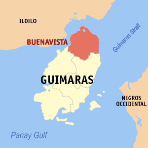
Buenavista, Guimaras
Encyclopedia

Philippines
The Philippines , officially known as the Republic of the Philippines , is a country in Southeast Asia in the western Pacific Ocean. To its north across the Luzon Strait lies Taiwan. West across the South China Sea sits Vietnam...
.
The town acts as a cheaper link between Panay
Panay Island
Panay is an island in the Philippines located in the western part of the Visayas. Politically, it is divided into five provinces: Aklan, Antique, Capiz, and Iloilo, all in the Western Visayas Region. It is located southeast of the island of Mindoro and northwest of Negros, separated by the...
and Negros, as opposed to taking a ship directly between the two islands.
According to the 2000 census, it has a population of 41,717 people in 8,373 households.
History
Buenavista is the oldest municipality in GuimarasGuimaras
Guimaras is an island province of the Philippines located in the Western Visayas region. Among the smallest provinces, its capital is Jordan. The island is located in the Panay Gulf, between the islands of Panay and Negros...
. It was established in 1775, during the Spanish period. Historians claim that a Spanish governor general, struck by the municipality’s scenery, called the old town site beautiful view.
Santo Rosario was formerly known as Baybay, while Salvacion's old name was Ambulong.
Location and accessibility
Buenavista is located at the northern tip of Guimaras Island, and is one of the five towns comprising the province of Guimaras. The northern and northwest part of the town overlooks Panay IslandPanay Island
Panay is an island in the Philippines located in the western part of the Visayas. Politically, it is divided into five provinces: Aklan, Antique, Capiz, and Iloilo, all in the Western Visayas Region. It is located southeast of the island of Mindoro and northwest of Negros, separated by the...
and the northeast portion faces Negros Island. Iloilo Strait lies between the town and Panay, and Guimaras Strait lies between the town and Negros. The McArthur wharf serves as the municipal wharf for Buenavista and part of San Lorenzo
San Lorenzo, Guimaras
San Lorenzo is a 5th class municipality in the province of Guimaras, Philippines. According to the 2000 census, it has a population of 20,168 people in 3,809 households.-Barangays:San Lorenzo is politically subdivided into 12 barangays.* Aguilar* Cabano...
is used by passengers from the neighboring Panay Island in going to Negros Province and vice versa. This transportation route serves as a cheaper link, rather than taking a ship.
Buenavista has terrain ranging from plains to mountains. The climate is mild and cool, due to its being bounded by the sea on the three directions.
Barangays
Buenavista is politically subdivided into 36 barangayBarangay
A barangay is the smallest administrative division in the Philippines and is the native Filipino term for a village, district or ward...
s.
|
|
|

