

Guiuan, Eastern Samar
Encyclopedia
Guiuan is a 2nd class municipality in the province of Eastern Samar, Philippines
. As of year 2004, it has a population of 43,647 people in 7,618 households.
Guiuan is a significant part of the Philippine history. In the 16th century, when Ferdinand Magellan discovered the Philippines, it is believed that he first landed on the island of Homonhon. It is probably because of this fact that the majority of the population of the town are devout Catholics and the town's church, the Church of the Immaculate Conception, is one of the oldest in the country.
During the Second World War, Guiuan served as one of the Alliance's bases. What's left of the American occupation nowadays are just concrete slabs which once served as the foundations of a vast supply depot, and an air strip which now serves as the town's own airport.
Besides the rich historical background, Guiuan boasts many beautiful scenic spots including white sand beaches. Being a coastal town in the Pacific side, the town is blessed with many beaches that are perfect for swimming and surfing.
The name of the town originated from its geographical location. The first settlers named the town “Guibang” when they discovered a sharp break in the mountain range (Tenigbang – partly chiseled off) which screens the town from the Pacific Ocean in the East. Subsequently, settlers modified its name to Guiuan.
The occurrence of World War II shook the town and people moved to the mountains to find comfort. On June 28, 1943, several Japanese soldiers set foot on Guiuan soil. Not as fearful and brutal as they were thought of by the local populace, a cordial relation soon existed between the conquered and the conquerors. Evacuees came down from the mountains and resumed a normal urban life.
Except for a few killings of suspected traitors by both Japanese, Filipino soldiers and local guerillas, not a drop of blood was shed needlessly. This made Guiuan one of the few places in the islands where World War II did not leave so many tragic memories.
The first sign of liberation of the town came on November 27, 1944 when a US Navy submarine chaser steamed the harbor for reconnaissance duty. On December 1, 1944 a fleet of LCTs, Liberty ships and barges poured into the Guiuan Bay to unload machines that was to transform Guiuan into one of the biggest Naval Base in the Far East that time.
In 1952, the sitios of Talisay, Bagambang, Calamrisan, Lo-ok and Barawalti, belonging to Barrio Tubabao, were separated and created into the barrio of Trinidad.
Many years after the American Liberation, Guiuan has slowly progressed from a sleepy town to a bustling municipality.
On November 10, 1978, Proclamation No. 1801 was issued declaring Guiuan, Eastern Samar as a Tourist Zone and Marine Reserve under the administration and control of the Philippine Tourism Authority (PTA).
Clustered around the municipality are numerous islands and islets, like Tubabao, Calicoan, Sulangan, Homonhonand Suluan.
Guiuan is 109 kilometers south of Borongan and 154kilometers from Tacloban. It has a total land area of
175.49 square kilometers. It is composed of sixty (60)
barangays and the only town in the province with biggest number of island barangays.
The coastal waters offer almost all species of marine life: euchuema, abalone, ornamental fish, lobster and the GoldenCowry (known for its extraordinary goldensheen). They also offer delicacies, shellcraft products as well as fresh andprocessed marine products.
Existing land use indicates a predominanceof agriculture use which covers 38.2% of the total land area. Most of the agriculturallands are dominantly planted with coconuttrees.
Other major crops include vegetables, rootcrops, palay, corn, banana and other fruit trees, coffee and pineapple.
The municipality is likewise rich in mineral resources. It has an estimated mineral reserve of bauxite, nickel and titaferous magnitie of more than 26.7 million metric tons.
Guiuan also has a municipal and national seaport operational throughout the year.
Telephone companies operating in the municipality includes TELECOM, Globelines and Bayantel. Smart and Globe cellular phone companies are also operational.
In 2004, Eastern Samar Electric Cooperative (ESAMELCO) was able to energize Guiuan, Calicoan Island up to Sulangan covering 37 out of 60 barangays. Island barangays are served with electricity through generator sets either privately-owned or operated by the barangay council. However, electricity shortages are frequent and subscribers experience weekly power failures, often lasting 24 hours.
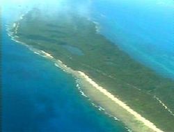 Calicoan Island boasts white sand beaches with rocky bottoms.
In the middle of the island are six lagoonsringed by forest, the largest being 30hectares in size.
At the cliffside margin of Calicoan's forestsare dozens of caves.
On the northern tip of Calicoan arewetlands like the Everglades, teeming withfish, shrimp, and crabs.
The rich diversity of the area is evident when one sees the exotic species being sold. The surrounding waters support several marine based industries such as fish, seaweed, and pearl farming.
Calicoan Island is envisioned to become the surfing capital and a top tourist destination in Eastern Visayas. So far however, progress has been minimal.
s.
Philippines
The Philippines , officially known as the Republic of the Philippines , is a country in Southeast Asia in the western Pacific Ocean. To its north across the Luzon Strait lies Taiwan. West across the South China Sea sits Vietnam...
. As of year 2004, it has a population of 43,647 people in 7,618 households.
Guiuan is a significant part of the Philippine history. In the 16th century, when Ferdinand Magellan discovered the Philippines, it is believed that he first landed on the island of Homonhon. It is probably because of this fact that the majority of the population of the town are devout Catholics and the town's church, the Church of the Immaculate Conception, is one of the oldest in the country.
During the Second World War, Guiuan served as one of the Alliance's bases. What's left of the American occupation nowadays are just concrete slabs which once served as the foundations of a vast supply depot, and an air strip which now serves as the town's own airport.
Besides the rich historical background, Guiuan boasts many beautiful scenic spots including white sand beaches. Being a coastal town in the Pacific side, the town is blessed with many beaches that are perfect for swimming and surfing.
History
Guiuan is widely known for two significant events in history 423 years apart. In 1521, Ferdinand Magellan first set foot on Philippine soil in Homonhon on his way to discover the Philippines for the Western World. In 1944, the American Forces landed on the island of Suluan where they fought their first battle in the Philippine territory three days before Gen. Mac Arthur stormed the beaches of Leyte.The name of the town originated from its geographical location. The first settlers named the town “Guibang” when they discovered a sharp break in the mountain range (Tenigbang – partly chiseled off) which screens the town from the Pacific Ocean in the East. Subsequently, settlers modified its name to Guiuan.
The occurrence of World War II shook the town and people moved to the mountains to find comfort. On June 28, 1943, several Japanese soldiers set foot on Guiuan soil. Not as fearful and brutal as they were thought of by the local populace, a cordial relation soon existed between the conquered and the conquerors. Evacuees came down from the mountains and resumed a normal urban life.
Except for a few killings of suspected traitors by both Japanese, Filipino soldiers and local guerillas, not a drop of blood was shed needlessly. This made Guiuan one of the few places in the islands where World War II did not leave so many tragic memories.
The first sign of liberation of the town came on November 27, 1944 when a US Navy submarine chaser steamed the harbor for reconnaissance duty. On December 1, 1944 a fleet of LCTs, Liberty ships and barges poured into the Guiuan Bay to unload machines that was to transform Guiuan into one of the biggest Naval Base in the Far East that time.
In 1952, the sitios of Talisay, Bagambang, Calamrisan, Lo-ok and Barawalti, belonging to Barrio Tubabao, were separated and created into the barrio of Trinidad.
Many years after the American Liberation, Guiuan has slowly progressed from a sleepy town to a bustling municipality.
On November 10, 1978, Proclamation No. 1801 was issued declaring Guiuan, Eastern Samar as a Tourist Zone and Marine Reserve under the administration and control of the Philippine Tourism Authority (PTA).
Geography
The municipality of Guiuan is located at the southernmost tip of Samar Island. It is bounded on the north by the municipality of Mercedes, on the eastby the Pacific Ocean, on the south by the Surigao Strait, and on the west by the Leyte Gulf.Clustered around the municipality are numerous islands and islets, like Tubabao, Calicoan, Sulangan, Homonhonand Suluan.
Guiuan is 109 kilometers south of Borongan and 154kilometers from Tacloban. It has a total land area of
175.49 square kilometers. It is composed of sixty (60)
barangays and the only town in the province with biggest number of island barangays.
Demography
Guiuan recorded a total population of 38,694 in 2000, the second largest population in Eastern Samar with the highest population density of 220 persons per km2. among the twenty-three (23) municipalities. Majority or 97.7% of the Guiuananons speak the Waray-Waray language. Less than 3.0% speak Cebuano, Tagalog and Boholano. A small percentage can converse in English, with varying degrees of proficiency.Socio-Economic Activities
Being a fishing community and the only municipality with the most number of island barangays, the town is rich in fishery and aquatic resources. It is considered by the fisheries authorities as the best fishing belt in the region.The coastal waters offer almost all species of marine life: euchuema, abalone, ornamental fish, lobster and the GoldenCowry (known for its extraordinary goldensheen). They also offer delicacies, shellcraft products as well as fresh andprocessed marine products.
Existing land use indicates a predominanceof agriculture use which covers 38.2% of the total land area. Most of the agriculturallands are dominantly planted with coconuttrees.
Other major crops include vegetables, rootcrops, palay, corn, banana and other fruit trees, coffee and pineapple.
The municipality is likewise rich in mineral resources. It has an estimated mineral reserve of bauxite, nickel and titaferous magnitie of more than 26.7 million metric tons.
Facilities
Guiuan’s airport has a 2.8 km runway which could service light private planes, chartered cargo and military planes. Despite being partly renovated, it is still unused.Guiuan also has a municipal and national seaport operational throughout the year.
Telephone companies operating in the municipality includes TELECOM, Globelines and Bayantel. Smart and Globe cellular phone companies are also operational.
In 2004, Eastern Samar Electric Cooperative (ESAMELCO) was able to energize Guiuan, Calicoan Island up to Sulangan covering 37 out of 60 barangays. Island barangays are served with electricity through generator sets either privately-owned or operated by the barangay council. However, electricity shortages are frequent and subscribers experience weekly power failures, often lasting 24 hours.
Financial Resources
Guiuan is classified as a second income class municipality as of CY 2008. Its Total Financial Resources amounted to 67.71 million pesos. Its Internal Revenue Allotment (IRA) represents 78.0% of its total financial resources.Adventure Spot
In the middle of the island are six lagoonsringed by forest, the largest being 30hectares in size.
At the cliffside margin of Calicoan's forestsare dozens of caves.
On the northern tip of Calicoan arewetlands like the Everglades, teeming withfish, shrimp, and crabs.
The rich diversity of the area is evident when one sees the exotic species being sold. The surrounding waters support several marine based industries such as fish, seaweed, and pearl farming.
Getting there
Calicoan island is readily accessible by land. The nearby regional capital of Tacloban is only two to three hours away. Several buses and vans regularly shuttle passengers to Guiuan. Tacloban is regularly serviced by scheduled flights from Manila. Alternatively, several bus companies have daily trips to Guiuan from Manila. Travel time is approximately twenty-one hours. Guiuan is also 2 hours away from the provincial capital, Borongan.Calicoan Island is envisioned to become the surfing capital and a top tourist destination in Eastern Visayas. So far however, progress has been minimal.
Barangays
Guiuan is politically subdivided into 60 barangayBarangay
A barangay is the smallest administrative division in the Philippines and is the native Filipino term for a village, district or ward...
s.
|
|
|