

List of Florida hurricanes (1975-1999)
Encyclopedia
_tracks.jpg)
Atlantic hurricane
North Atlantic tropical cyclones usually form in the northern hemisphere summer or fall. Tropical cyclones can be categorized by intensity. Tropical storms have one-minute maximum sustained winds of at least 39 mph , while hurricanes have one-minute maximum sustained exceeding 74 mph...
tropical cyclone
Tropical cyclone
A tropical cyclone is a storm system characterized by a large low-pressure center and numerous thunderstorms that produce strong winds and heavy rain. Tropical cyclones strengthen when water evaporated from the ocean is released as the saturated air rises, resulting in condensation of water vapor...
s that affected the U.S. state
U.S. state
A U.S. state is any one of the 50 federated states of the United States of America that share sovereignty with the federal government. Because of this shared sovereignty, an American is a citizen both of the federal entity and of his or her state of domicile. Four states use the official title of...
of Florida
Florida
Florida is a state in the southeastern United States, located on the nation's Atlantic and Gulf coasts. It is bordered to the west by the Gulf of Mexico, to the north by Alabama and Georgia and to the east by the Atlantic Ocean. With a population of 18,801,310 as measured by the 2010 census, it...
. Collectively, tropical cyclones in Florida during the time period resulted in at least $45 billion (2008 USD) in damage, primarily from Hurricane Andrew
Hurricane Andrew
Hurricane Andrew was the third Category 5 hurricane to make landfall in the United States, after the Labor Day Hurricane of 1935 and Hurricane Camille in 1969. Andrew was the first named storm and only major hurricane of the otherwise inactive 1992 Atlantic hurricane season...
. Additionally, tropical cyclones in Florida were directly responsible for 54 fatalities during the period. Several tropical cyclones produced over 20 inches (500 mm) of rainfall in the state, including Hurricane Georges
Hurricane Georges
Hurricane Georges was a very destructive, powerful and long-lived Cape Verde-type Category 4 hurricane. Georges was the seventh tropical storm, fourth hurricane, and second major hurricane of the 1998 Atlantic hurricane season...
which is the highest total during the time period. The 1985 season
1985 Atlantic hurricane season
The 1985 Atlantic hurricane season had the most U.S. landfalling tropical cyclones since 1916. The season officially began on June 1, 1985, and lasted until November 30, 1985...
was the year with the most tropical cyclones affecting the state, with a total of eight systems. Every year included at least one tropical cyclone affecting the state.
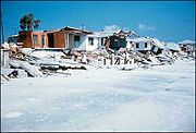
The strongest hurricane to hit the state during the time period was Hurricane Andrew
Hurricane Andrew
Hurricane Andrew was the third Category 5 hurricane to make landfall in the United States, after the Labor Day Hurricane of 1935 and Hurricane Camille in 1969. Andrew was the first named storm and only major hurricane of the otherwise inactive 1992 Atlantic hurricane season...
, which was one of only three Category 5 hurricanes to strike the United States. Andrew, at the time, was the costliest tropical cyclone in United States history. Additionally, Hurricane Eloise
Hurricane Eloise
Hurricane Eloise was the most destructive tropical cyclone of the 1975 Atlantic hurricane season. The fifth tropical storm, fourth hurricane, and second major hurricane of the season, Eloise formed as a tropical depression on September 13 to the east of the Virgin Islands...
and Hurricane Opal
Hurricane Opal
Hurricane Opal was a Category 4 hurricane that formed in the Gulf of Mexico in September 1995.Opal was the ninth hurricane and the strongest of the abnormally active 1995 Atlantic hurricane season...
hit the state as major hurricanes
Tropical cyclone scales
Tropical systems are officially ranked on one of several tropical cyclone scales according to their maximum sustained winds and in what oceanic basin they are located...
.
1975
- June 27, 1975- The tropical depression that later becomes Tropical Storm AmyTropical Storm Amy (1975)Tropical Storm Amy was the first tropical cyclone to develop during the 1975 Atlantic hurricane season. Forming on June 28 from a trough of low pressure, Amy gradually attained tropical storm status off the coast of North Carolina. A rapidly approaching trough caused Amy to turn sharply...
drops light rainfall in the eastern portion of the state. - July 29, 1975- A tropical depression moves into southern MississippiMississippiMississippi is a U.S. state located in the Southern United States. Jackson is the state capital and largest city. The name of the state derives from the Mississippi River, which flows along its western boundary, whose name comes from the Ojibwe word misi-ziibi...
after creating a strong convergence zoneConvergence zoneConvergence zone usually refers to a region in the atmosphere where two prevailing flows meet and interact, usually resulting in distinctive weather conditions....
with a ridgeRidge (meteorology)A ridge is an elongated region of relatively high atmospheric pressure, the opposite of a trough....
over the western Atlantic OceanAtlantic OceanThe Atlantic Ocean is the second-largest of the world's oceanic divisions. With a total area of about , it covers approximately 20% of the Earth's surface and about 26% of its water surface area...
. The convergence zone produces heavy rainfall of up to 20 inches (510 mm) along the western Florida PanhandleFlorida PanhandleThe Florida Panhandle, an informal, unofficial term for the northwestern part of Florida, is a strip of land roughly 200 miles long and 50 to 100 miles wide , lying between Alabama on the north and the west, Georgia also on the north, and the Gulf of Mexico to the south. Its eastern boundary is...
, resulting in moderate stream flooding and $8.5 million in damage in the state (1975 USD, $34 million 2008 USD).
- September 23, 1975- Hurricane EloiseHurricane EloiseHurricane Eloise was the most destructive tropical cyclone of the 1975 Atlantic hurricane season. The fifth tropical storm, fourth hurricane, and second major hurricane of the season, Eloise formed as a tropical depression on September 13 to the east of the Virgin Islands...
makes landfall near DestinDestin, FloridaDestin is a city located in Okaloosa County, Florida. It is a principal city of the Fort Walton Beach-Crestview-Destin, Florida Metropolitan Statistical Area.Located on Florida's Emerald Coast, Destin is known for its white beaches and emerald green waters...
with winds of about 125 mph (200 km/h), producing light precipitation across the peninsula with heavier amounts near the landfall location peaking at 14.9 inches (378 mm) at Eglin Air Force BaseEglin Air Force BaseEglin Air Force Base is a United States Air Force base located approximately 3 miles southwest of Valparaiso, Florida in Okaloosa County....
. Hurricane force winds and storm surgeStorm surgeA storm surge is an offshore rise of water associated with a low pressure weather system, typically tropical cyclones and strong extratropical cyclones. Storm surges are caused primarily by high winds pushing on the ocean's surface. The wind causes the water to pile up higher than the ordinary sea...
of up to 16 feet (4.9 m) across the panhandle destroy 500 small businesses and damage or destroy 8,000 houses. Damage in the state totals $100 million (1975 USD, $400 million 2008 USD). - October 1, 1975- A tropical depression hits the western Florida PanhandleFlorida PanhandleThe Florida Panhandle, an informal, unofficial term for the northwestern part of Florida, is a strip of land roughly 200 miles long and 50 to 100 miles wide , lying between Alabama on the north and the west, Georgia also on the north, and the Gulf of Mexico to the south. Its eastern boundary is...
, though its effects, if any, are unknown. - October 16, 1975- Southern LouisianaLouisianaLouisiana is a state located in the southern region of the United States of America. Its capital is Baton Rouge and largest city is New Orleans. Louisiana is the only state in the U.S. with political subdivisions termed parishes, which are local governments equivalent to counties...
is struck by a tropical depression, with its outer rain squallsRainbandA rainband is a cloud and precipitation structure associated with an area of rainfall which is significantly elongated. Rainbands can be stratiform or convective, and are generated by differences in temperature. When noted on weather radar imagery, this precipitation elongation is referred to as...
and slightly above normal tides reaching the northwestern portion of Florida.
1976
- May 23, 1976- Subtropical Storm One strikes near Saint Marks, producing slightly above normal tides, minor beach erosion, and beneficial precipitation.
- June 11, 1976- A tropical depression moves northeastward across the southern portion of the state, resulting in only minor effects.
- August 19, 1976- Tropical Storm Dottie hits the southwestern portion of the state, dropping heavy precipitation across its path including around 8 inches (200 mm) in the Coral GablesCoral Gables, FloridaCoral Gables is a city in Miami-Dade County, Florida, southwest of Downtown Miami, in the United States. The city is home to the University of Miami....
. The rainfall led to flooding and road closures near MiamiMiami, FloridaMiami is a city located on the Atlantic coast in southeastern Florida and the county seat of Miami-Dade County, the most populous county in Florida and the eighth-most populous county in the United States with a population of 2,500,625...
. - September 13, 1976- The combination of a mid-level low and a stationary front lead to the development of Subtropical Depression ThreeSubtropical cycloneA subtropical cyclone is a weather system that has some characteristics of a tropical and an extratropical cyclone. As early as the 1950s, meteorologists were unclear whether they should be characterized as tropical or extratropical cyclones. They were officially recognized by the National...
over the center of the state. It tracks north-northeastward and intensifies into a subtropical storm, though its effects in the state, if any, are unknown.
1977
- August 27, 1977- The precursor tropical disturbance of Hurricane AnitaHurricane AnitaHurricane Anita was a powerful Atlantic hurricane during an otherwise quiet 1977 Atlantic hurricane season. The first tropical cyclone of the season, Anita developed from a tropical wave on August 29 in the north-central Gulf of Mexico. It tracked westward into an area with conditions favorable for...
crosses the state and drops light precipitation.

- September 5, 1977- The outer rainbandRainbandA rainband is a cloud and precipitation structure associated with an area of rainfall which is significantly elongated. Rainbands can be stratiform or convective, and are generated by differences in temperature. When noted on weather radar imagery, this precipitation elongation is referred to as...
s of Hurricane BabeHurricane Babe (1977)Hurricane Babe was the second named storm and the first to impact the United States during the below-average 1977 Atlantic hurricane season. Forming out of a tropical wave on September 3, Babe began as a subtropical cyclone in the eastern Gulf of Mexico. The storm gradually intensified as it...
produce moderate rainfall throughout the state as it makes landfall on southern LouisianaLouisianaLouisiana is a state located in the southern region of the United States of America. Its capital is Baton Rouge and largest city is New Orleans. Louisiana is the only state in the U.S. with political subdivisions termed parishes, which are local governments equivalent to counties...
.
1978
- June 22, 1978- A tropical depression dissipates shortly after striking the southwestern portion of the state. Damage, if any, is unknown.
1979
- July 11, 1979- Hurricane BobHurricane Bob (1979)Hurricane Bob was a minimal hurricane that brought rainfall throughout several states, killing one person and causing over $20 million in damage. Bob was the fifth tropical depression, second named storm, and first hurricane of the 1979 Atlantic hurricane season...
hits southern LouisianaLouisianaLouisiana is a state located in the southern region of the United States of America. Its capital is Baton Rouge and largest city is New Orleans. Louisiana is the only state in the U.S. with political subdivisions termed parishes, which are local governments equivalent to counties...
, with its outer rainbandRainbandA rainband is a cloud and precipitation structure associated with an area of rainfall which is significantly elongated. Rainbands can be stratiform or convective, and are generated by differences in temperature. When noted on weather radar imagery, this precipitation elongation is referred to as...
s dropping 3 inches (76.2 mm) of rain along the western Florida PanhandleFlorida PanhandleThe Florida Panhandle, an informal, unofficial term for the northwestern part of Florida, is a strip of land roughly 200 miles long and 50 to 100 miles wide , lying between Alabama on the north and the west, Georgia also on the north, and the Gulf of Mexico to the south. Its eastern boundary is...
. - September 3, 1979- Hurricane DavidHurricane DavidHurricane David was the fourth named tropical cyclone, second hurricane, and first major hurricane of the 1979 Atlantic hurricane season. A Category 5 hurricane on the Saffir-Simpson Hurricane Scale, David was among the deadliest hurricanes in the latter half of the 20th century, killing...
brushes the eastern coastline after moving ashore near Palm BeachPalm Beach, FloridaThe Town of Palm Beach is an incorporated town in Palm Beach County, Florida, United States. The Intracoastal Waterway separates it from the neighboring cities of West Palm Beach and Lake Worth...
, producing heavy rainfall with one location reporting over 10 inches (250 mm) of precipitation, as well as strong winds which result in $95 million in damage (1979 USD, $282 million 2008 USD), primarily in Palm Beach CountyPalm Beach County, FloridaPalm Beach County is the largest county in the state of Florida in total area, and third in population. As of 2010, the county's estimated population was 1,320,134, making it the twenty-eighth most populous in the United States...
. The hurricane causes five casualties in the state. - September 12, 1979- Hurricane FredericHurricane FredericHurricane Frederic was the sixth tropical cyclone, third hurricane and second major hurricane of the 1979 Atlantic hurricane season. Frederic was the costliest hurricane to ever hit the U.S. Gulf Coast at that particular time...
makes landfall near the AlabamaAlabamaAlabama is a state located in the southeastern region of the United States. It is bordered by Tennessee to the north, Georgia to the east, Florida and the Gulf of Mexico to the south, and Mississippi to the west. Alabama ranks 30th in total land area and ranks second in the size of its inland...
/MississippiMississippiMississippi is a U.S. state located in the Southern United States. Jackson is the state capital and largest city. The name of the state derives from the Mississippi River, which flows along its western boundary, whose name comes from the Ojibwe word misi-ziibi...
border, having produced tropical storm force winds in the Dry TortugasDry TortugasThe Dry Tortugas are a small group of islands, located at the end of the Florida Keys, USA, about west of Key West, and west of the Marquesas Keys, the closest islands. Still further west is the Tortugas Bank, which is completely submerged. The first Europeans to discover the islands were the...
a few days before. The hurricane drops rainfall throughout the state and kills one person off PensacolaPensacola, FloridaPensacola is the westernmost city in the Florida Panhandle and the county seat of Escambia County, Florida, United States of America. As of the 2000 census, the city had a total population of 56,255 and as of 2009, the estimated population was 53,752...
when a person is swept from their boat. - September 24, 1979- The remnants of Hurricane HenriHurricane Henri (1979)Hurricane Henri was a rare tropical cyclone that entered the Gulf of Mexico without having made landfall; it was the second of four times this occurred during the 20th century. The eighth named storm and fifth hurricane of the 1979 Atlantic hurricane season, it formed on September 14 in the...
bring rainfall and river flooding to the western portion of the state.
1980

- August 7, 1980- Hurricane AllenHurricane AllenHurricane Allen was the first and strongest hurricane of the 1980 Atlantic hurricane season. It was one of the strongest hurricanes in recorded history, one of the few hurricanes to reach Category 5 status on the Saffir-Simpson Hurricane Scale on three separate occasions, and spent more time...
passes about 310 miles (500 km) south of Key West, FloridaKey West, FloridaKey West is a city in Monroe County, Florida, United States. The city encompasses the island of Key West, the part of Stock Island north of U.S. 1 , Sigsbee Park , Fleming Key , and Sunset Key...
. The threat of the large hurricane prompts the National Hurricane CenterNational Hurricane CenterThe National Hurricane Center , located at Florida International University in Miami, Florida, is the division of the National Weather Service responsible for tracking and predicting weather systems within the tropics between the Prime Meridian and the 140th meridian west poleward to the 30th...
to issue gale warningGale warningA gale warning is a warning issued by weather services in maritime locations about the existence of winds of gale force or above or the imminent occurrence of gales at sea...
s for the Florida KeysFlorida KeysThe Florida Keys are a coral archipelago in southeast United States. They begin at the southeastern tip of the Florida peninsula, about south of Miami, and extend in a gentle arc south-southwest and then westward to Key West, the westernmost of the inhabited islands, and on to the uninhabited Dry...
. The hurricane produces gale force winds across the keys, though there was no significant damage. - November 8–12, 1980- An inflow band from Hurricane JeanneHurricane Jeanne (1980)Hurricane Jeanne was a moderate hurricane that formed and dissipated in the Gulf of Mexico without making landfall. The tenth tropical cyclone and eighth hurricane of the 1980 Atlantic hurricane season, Jeanne developed over the southern Caribbean on November 7. It moved swiftly northward, and it...
over the central Gulf of MexicoGulf of MexicoThe Gulf of Mexico is a partially landlocked ocean basin largely surrounded by the North American continent and the island of Cuba. It is bounded on the northeast, north and northwest by the Gulf Coast of the United States, on the southwest and south by Mexico, and on the southeast by Cuba. In...
combines with a stationary cold frontSurface weather analysisSurface weather analysis is a special type of weather map that provides a view of weather elements over a geographical area at a specified time based on information from ground-based weather stations...
, producing torrential rainfall across southern FloridaFloridaFlorida is a state in the southeastern United States, located on the nation's Atlantic and Gulf coasts. It is bordered to the west by the Gulf of Mexico, to the north by Alabama and Georgia and to the east by the Atlantic Ocean. With a population of 18,801,310 as measured by the 2010 census, it...
. Key West International AirportKey West International AirportKey West International Airport is a county-owned public airport located two miles east of the central business district of Key West, in Monroe County, Florida, United States....
records a peak total of 24.98 inches (634 mm), with over half of it falling in one six-hour period. - November 18, 1980- A tropical depression brings moderate precipitation to the state after merging with Hurricane Jeanne.
1981
- August 17, 1981- Tropical Storm DennisHurricane Dennis (1981)Hurricane Dennis was the most damaging storm of the 1981 Atlantic hurricane season which took twelve and a half days to reach hurricane status. The tropical wave that later would become Dennis moved off the African coastline on August 5. By August 7 a tropical depression developed, which quickly...
makes landfall on the southwest portion of the state, and drifts northeastward across the state. The rainfall is generally beneficial, though totals of over 20 inches (500 mm) cause moderate flooding damage in southeastern Florida, including $15 million ($36 million 2008 USD) in crop damages in Dade County. - November, 1981- An unnamed subtropical storm produces coastal flooding and beach erosion along the eastern coastline while located over the open Atlantic OceanAtlantic OceanThe Atlantic Ocean is the second-largest of the world's oceanic divisions. With a total area of about , it covers approximately 20% of the Earth's surface and about 26% of its water surface area...
.
1982
- Early June, 1982- Hurricane AlbertoHurricane Alberto (1982)Hurricane Alberto caused the worst flooding in western Cuba in 32 years. The first tropical storm and hurricane of the 1982 Atlantic hurricane season, Alberto developed from a tropical disturbance on June 2 in the southern Gulf of Mexico...
stalls over the eastern Gulf of Mexico, though its outer bands produce moderate rainfall across the state, peaking at 16.47 inches (418 mm) in TavernierTavernier, FloridaTavernier is a census-designated place in Monroe County, Florida, on an island named Key Largo in the upper Florida Keys. The population was 2,173 at the 2000 census.-Geography:Tavernier is located at ....
. The hurricane produces tornadic activity across the state, and the storm results in generally minor damage. - June 18, 1982- A subtropical stormSubtropical Storm One (1982)The 1982 Florida subtropical storm, officially known as Subtropical Storm One, was the only subtropical cyclone of the inactive 1982 Atlantic hurricane season. The storm originated from two different systems around the Gulf of Mexico and Caribbean Sea on June 16. The systems merged into trough...
makes landfall near YankeetownYankeetown, FloridaYankeetown is a town in Levy County, Florida, United States. The population was 629 at the 2000 census. According to the U.S. Census Bureau's 2004 estimates, the town had a population of 672.-History:...
, and produces moderate precipitation of up to 10.72 inches (272 mm) near Desoto City. The rainfall leads to 3 deaths, and damage from the storm totals to $10 million (1982 USD, $22 million 2008 USD). - September 11, 1982- Tropical Storm Chris strikes LouisianaLouisianaLouisiana is a state located in the southern region of the United States of America. Its capital is Baton Rouge and largest city is New Orleans. Louisiana is the only state in the U.S. with political subdivisions termed parishes, which are local governments equivalent to counties...
, with its outer rainbands dropping over 7 inches (175 mm) of precipitation near ApalachicolaApalachicola, FloridaApalachicola is a city in Franklin County, Florida, on US 98 about southwest of Tallahassee. The population was 2,334 at the 2000 census. The 2005 census estimated the city's population at 2,340...
.
1983
- August 28, 1983- Tropical Depression BarryHurricane Barry (1983)Hurricane Barry was the fourth tropical depression, second hurricane and named storm of the inactive 1983 Atlantic hurricane season. Developing out of a tropical wave on August 23, Barry quickly strengthened off the coast of Florida, reaching an initial peak intensity with winds of 60 mph...
makes landfall as a tropical depression near MelbourneMelbourne, FloridaMelbourne is a city in Brevard County, Florida, United States. As of 2009, the population estimated by the U.S. Census Bureau is 78,323. The municipal area is the second largest by size and by population in the county. Melbourne is a principal city of the Palm Bay – Melbourne – Titusville, Florida...
. It drops light rainfall across the southern portion of the state, peaking at 3.01 inches (76 mm) in Wachula.
1984
- September 9, 1984- Tropical Storm DianaHurricane Diana (1984)Hurricane Diana was the fourth tropical storm, the first hurricane, the first major hurricane, and the strongest storm of the 1984 Atlantic hurricane season. Diana was the first major hurricane to hit the U.S. East Coast in nearly 20 years. Watches and warnings were issued for the storm...
passes within 65 miles (100 km) off the northeast Florida coast. The storm produces moderate rainfall of up to 3.13 inches (79.5 mm) in JacksonvilleJacksonville, FloridaJacksonville is the largest city in the U.S. state of Florida in terms of both population and land area, and the largest city by area in the contiguous United States. It is the county seat of Duval County, with which the city government consolidated in 1968...
. Diana also produces wind gusts of up to 69 mph (112 km/h) as well as tidesStorm tideA storm tide is a tide with a high flood period caused by a storm. Storm tides can be a severe danger to the coast and the people living along the coast. The water level can rise to more than 5 meters above the normal tide....
2.6 feet (0.8 m) above normal. - September 27, 1984- Tropical Storm IsidoreTropical Storm Isidore (1984)Tropical Storm Isidore was the 15th tropical cyclone and 9th named storm of the 1984 Atlantic hurricane season. Isidore formed as a tropical depression on September 25, while situated off the southeastern Bahamas. The depression headed west, and was upgraded to a tropical storm in the central...
makes landfall on JupiterJupiter, FloridaJupiter is a town located in Palm Beach County, Florida. As of the 2000 census, the town had a total population of 39,328. The estimate population for 2009 is 50,606. As of 2006, the population had grown to 50,028, according to the University of Florida, Bureau of Economic and Business Research....
with 60 mph (95 km/h) winds. Isidore drops moderate rainfall of over to 6.5 inches (175 mm), and produces a storm tide of around 3.2 feet (1 m). Isidore kills one person and causes $1 million in damage (1984 USD, $2.1 million 2008 USD) across the state. - October 26, 1984- A tropical depression crosses the state without dropping much precipitation.
1985
- July 23, 1985- Tropical Storm BobHurricane Bob (1985)Hurricane Bob was a hurricane that affected the southeast United States in July 1985. The second tropical storm and first hurricane of the 1985 Atlantic hurricane season, the system developed from a tropical wave on July 21 in the eastern Gulf of Mexico. Bob began moving east, striking southwestern...
makes landfall near Fort MyersFort Myers, FloridaFort Myers is the county seat and commercial center of Lee County, Florida, United States. Its population was 62,298 in the 2010 census, a 29.23 percent increase over the 2000 figure....
, and while slowly moving across the state it drops heavy rainfall peaking at 21.5 inches (546.1 mm) in Everglades City. Despite the rainfall, damage is minimal. - August 15, 1985- Hurricane DannyHurricane Danny (1985)Hurricane Danny was a minimal Category 1 hurricane on the Saffir-Simpson hurricane scale that made landfall in the U.S. state of Louisiana. The fourth tropical cyclone and third hurricane of the 1985 Atlantic hurricane season, Danny originated from a tropical wave that moved into the western...
strikes southern AlabamaAlabamaAlabama is a state located in the southeastern region of the United States. It is bordered by Tennessee to the north, Georgia to the east, Florida and the Gulf of Mexico to the south, and Mississippi to the west. Alabama ranks 30th in total land area and ranks second in the size of its inland...
, with its outer rainbands drop over 3 inches (75 mm) of rainfall in western Florida. - August 28 – September 6, 1985- Hurricane ElenaHurricane ElenaHurricane Elena was a category 3 major hurricane that produced heavy damage along the Gulf Coast of the United States in August and September of the 1985 Atlantic hurricane season. The fifth tropical storm, fourth hurricane, and first major hurricane of the season, Elena developed near Cuba from a...
moves northeastward through the Gulf of MexicoGulf of MexicoThe Gulf of Mexico is a partially landlocked ocean basin largely surrounded by the North American continent and the island of Cuba. It is bounded on the northeast, north and northwest by the Gulf Coast of the United States, on the southwest and south by Mexico, and on the southeast by Cuba. In...
, loops about 50 miles (80 km) off the coast of Cedar KeyCedar Key, FloridaCedar Key is a city in Levy County, Florida, United States. The population was 790 at the 2000 census. According to the U.S Census estimates of 2005, the city had a population of 958. The Cedar Keys are a cluster of islands close to the mainland. Most of the developed area of the city has been on...
, and turns northwestward to hit MississippiMississippiMississippi is a U.S. state located in the Southern United States. Jackson is the state capital and largest city. The name of the state derives from the Mississippi River, which flows along its western boundary, whose name comes from the Ojibwe word misi-ziibi...
. The hurricane produces precipitation across the entire state, with a peak of 15.67 inches (398 mm) in Cross Key. Elena causes a 9.8 foot (3 m) storm surge near ApalachicolaApalachicola, FloridaApalachicola is a city in Franklin County, Florida, on US 98 about southwest of Tallahassee. The population was 2,334 at the 2000 census. The 2005 census estimated the city's population at 2,340...
, where the oysterOysterThe word oyster is used as a common name for a number of distinct groups of bivalve molluscs which live in marine or brackish habitats. The valves are highly calcified....
industry experiences severe losses from the hurricane.

- October 10, 1985- Minimal Tropical Storm IsabelTropical Storm Isabel (1985)Tropical Storm Isabel was the ninth tropical storm of the 1985 Atlantic hurricane season. The storm's track extended from the Caribbean to the southeastern United States during the second week of October. Prior to developing into a tropical cyclone, it produced torrential rainfall, resulting in...
hits extreme northeastern Florida, dropping light rain along its path; damage is minor. - Late October, 1985- Hurricane JuanHurricane Juan (1985)Hurricane Juan was a hurricane that formed in October 1985 and looped twice near the Louisiana coast, causing torrential flooding for several days. Juan was the costliest hurricane of the 1985 Atlantic hurricane season, and at the time was among the costliest of all historical U.S. hurricanes...
moves erratically over the northern Gulf of Mexico and hits PensacolaPensacola, FloridaPensacola is the westernmost city in the Florida Panhandle and the county seat of Escambia County, Florida, United States of America. As of the 2000 census, the city had a total population of 56,255 and as of 2009, the estimated population was 53,752...
as a tropical storm. It produces precipitation across much of the state, peaking at over 10 inches (250 mm) in the extreme western Florida Panhandle. - November 21, 1985- Hurricane KateHurricane Kate (1985)Hurricane Kate was the sixth hurricane to hit the United States during the 1985 Atlantic hurricane season, tying a record. Forming late in the season, it killed 15 people and caused $530 million in damage on its long path through Cuba, Florida, and Georgia between November 18 and...
makes landfall near Apalachicola as a Category 2 hurricaneSaffir-Simpson Hurricane ScaleThe Saffir–Simpson Hurricane Scale , or the Saffir–Simpson Hurricane Wind Scale , classifies hurricanes — Western Hemisphere tropical cyclones that exceed the intensities of tropical depressions and tropical storms — into five categories distinguished by the intensities of their sustained winds...
, producing up to 8.32 inches (147 mm) of rainfall in Panama CityPanama City, Florida-Personal income:The median income for a household in the city was $31,572, and the median income for a family was $40,890. Males had a median income of $30,401 versus $21,431 for females. The per capita income for the city was $17,830...
. Tides of over 10 feet (3 m) above normal result in further beach erosion near the coast. Just two months after Hurricane Elena affected the area, the passage of Hurricane Kate causes further damage to oyster beds, leaving many people without employment. Kate causes $300 million (1985 USD, $600 million 2008 USD) in damage and three deaths in the state.
1986
- June 26, 1986- Hurricane BonnieHurricane Bonnie (1986)Hurricane Bonnie was the second named storm, and first hurricane of the 1986 Atlantic hurricane season. Forming on June 23, Bonnie developed out of an area of low pressure over the central Gulf of Mexico. The system gradually intensified and was declared Tropical Storm Bonnie the next day as...
strikes the TexasTexasTexas is the second largest U.S. state by both area and population, and the largest state by area in the contiguous United States.The name, based on the Caddo word "Tejas" meaning "friends" or "allies", was applied by the Spanish to the Caddo themselves and to the region of their settlement in...
coast, with its outer rainbandRainbandA rainband is a cloud and precipitation structure associated with an area of rainfall which is significantly elongated. Rainbands can be stratiform or convective, and are generated by differences in temperature. When noted on weather radar imagery, this precipitation elongation is referred to as...
s produce over 1 inch (25 mm) of rain in the extreme northwestern Florida PanhandleFlorida PanhandleThe Florida Panhandle, an informal, unofficial term for the northwestern part of Florida, is a strip of land roughly 200 miles long and 50 to 100 miles wide , lying between Alabama on the north and the west, Georgia also on the north, and the Gulf of Mexico to the south. Its eastern boundary is...
. - August 13, 1986- The precursor disturbance that later becomes Hurricane CharleyHurricane Charley (1986)Hurricane Charley was the costliest tropical cyclone of the 1986 Atlantic hurricane season. The third tropical storm and second hurricane of the season, Charley formed as a subtropical low on August 13 along the Florida panhandle. After moving off the coast of South Carolina, the system...
moves over northwestern Florida, causing light to moderate amounts of precipitation of up to 8.61 inches (219 mm) near SteinhatcheeSteinhatchee, FloridaSteinhatchee is a Gulf coastal community in the southern part of Taylor County, Florida. Steinhatchee is located at , 33 miles By Hwy 38.09 miles south of the county seat of Perry. Just aross the Steinhatchee River is Jena, which is in Dixie County. Steinhatchee is 19.27 Hwy miles North of The...
.
1987
- August 14, 1987- A tropical depressionUnnamed Tropical Storm (1987)The 1987 Gulf Coast tropical storm was the first tropical storm of the below-average 1987 Atlantic hurricane season. Originating from a tropical wave, the system was first classified as a tropical depression over the Gulf of Mexico, southeast of Texas, on August 9...
enters the Florida PanhandleFlorida PanhandleThe Florida Panhandle, an informal, unofficial term for the northwestern part of Florida, is a strip of land roughly 200 miles long and 50 to 100 miles wide , lying between Alabama on the north and the west, Georgia also on the north, and the Gulf of Mexico to the south. Its eastern boundary is...
from the northwest. It produces rainfall across much of the state, with the extreme western Florida Panhandle receiving over 10 inches (250 mm) of rain. - September 7, 1987- Tropical Depression Nine forms to the east of the state, producing over 3 inches (75 mm) of rain near HomesteadHomestead, FloridaHomestead is a city in Miami-Dade County, Florida, United States nestled between Biscayne National Park to the east and Everglades National Park to the west. Homestead is primarily a Miami suburb and a major agricultural area....
. - October 12, 1987- Hurricane FloydHurricane Floyd (1987)Hurricane Floyd was the only hurricane to make landfall in the United States in the 1987 Atlantic hurricane season. The final of seven tropical storms and three hurricanes, Floyd developed on October 9 just off the east coast of Nicaragua. After becoming a tropical storm, it moved northward...
moves through the Florida KeysFlorida KeysThe Florida Keys are a coral archipelago in southeast United States. They begin at the southeastern tip of the Florida peninsula, about south of Miami, and extend in a gentle arc south-southwest and then westward to Key West, the westernmost of the inhabited islands, and on to the uninhabited Dry...
, dropping up to 10.07 inches (256 mm) of rain in Fort PierceFort Pierce, FloridaFort Pierce, also spelled Ft. Pierce, is a city in St. Lucie County, Florida, USA. It is known as The Sunrise City. The population was 37,959 at the 2004 census. As of 2008, the population recorded by the U.S. Census Bureau is 41,000. It is the county seat of St. Lucie County.Fort Pierce is part...
. - November 4, 1987- The extratropical remnant of Tropical Depression FourteenTropical Depression Fourteen (1987)Tropical Depression Fourteen was the last tropical depression of the semi-active 1987 Atlantic hurricane season and was the third most destructive storm of the year. The depression formed on October 31, 1987 in the Caribbean Sea, heading along a northward path into the southern Gulf of Mexico and...
makes landfall near Spring Hill, FloridaSpring Hill, FloridaSpring Hill is a census-designated place in Hernando County, Florida, United States. The estimated population was 92,144 in 2007 by the United States Census. Spring Hill belongs to Florida's Nature Coast and is in the Tampa-St...
, dropping up to 10.23 inches (260 mm) of rain at Loxahatchee National Wildlife RefugeLoxahatchee National Wildlife RefugeThe 147,392 acre Arthur R. Marshall Loxahatchee National Wildlife Refuge includes the most northern remnant of the historic Everglades wetland ecosystem...
.
1988
- May 30, 1988- A tropical depression moves northward to the east of the state, producing light rainfall peaking at 3.18 inches (81 mm) in Pompano BeachPompano Beach, FloridaPompano Beach ) is a city in Broward County, Florida, along the coast of the Atlantic Ocean just to the north of Fort Lauderdale. The nearby Hillsboro Inlet forms part of the Atlantic Intracoastal Waterway. As of the 2010 census, the city's population was 99,845...
. - August 4, 1988- Tropical Storm BerylTropical Storm Beryl (1988)Tropical Storm Beryl was an unusual Atlantic tropical cyclone that formed over southeastern Louisiana in August 1988. The second tropical storm of the 1988 Atlantic hurricane season, Beryl developed from a slow-moving trough of low pressure on August 8...
forms to the south of MississippiMississippiMississippi is a U.S. state located in the Southern United States. Jackson is the state capital and largest city. The name of the state derives from the Mississippi River, which flows along its western boundary, whose name comes from the Ojibwe word misi-ziibi...
and moves slowly for several days over coastal areas of LouisianaLouisianaLouisiana is a state located in the southern region of the United States of America. Its capital is Baton Rouge and largest city is New Orleans. Louisiana is the only state in the U.S. with political subdivisions termed parishes, which are local governments equivalent to counties...
. The outer bandsRainbandA rainband is a cloud and precipitation structure associated with an area of rainfall which is significantly elongated. Rainbands can be stratiform or convective, and are generated by differences in temperature. When noted on weather radar imagery, this precipitation elongation is referred to as...
of the storm drop over 7 inches (175 mm) of rain along the Florida PanhandleFlorida PanhandleThe Florida Panhandle, an informal, unofficial term for the northwestern part of Florida, is a strip of land roughly 200 miles long and 50 to 100 miles wide , lying between Alabama on the north and the west, Georgia also on the north, and the Gulf of Mexico to the south. Its eastern boundary is...
, resulting in very minor damage. - August 13, 1988- Tropical Depression Four makes landfall in extreme northeastern Florida, producing light to moderate rainfall throughout the entire state peaking at 7.72 inches (196 mm) in HomesteadHomestead, FloridaHomestead is a city in Miami-Dade County, Florida, United States nestled between Biscayne National Park to the east and Everglades National Park to the west. Homestead is primarily a Miami suburb and a major agricultural area....
. - August 23, 1988- Tropical Storm ChrisTropical Storm Chris (1988)Tropical Storm Chris was a weak tropical storm that made landfall in Georgia during the 1988 Atlantic hurricane season. The third storm of the season, Chris was one of five Atlantic storms in the year to make landfall on the United States coastline. Chris formed as a tropical depression in the...
parallels the east coast of the state and drops over 3 inches (75 mm) of precipitation in various locations. - September 4, 1988- Tropical Depression Ten strikes LouisianaLouisianaLouisiana is a state located in the southern region of the United States of America. Its capital is Baton Rouge and largest city is New Orleans. Louisiana is the only state in the U.S. with political subdivisions termed parishes, which are local governments equivalent to counties...
, producing moderate rainfall across northern Florida with totals of over 5 inches (125 mm) near ApalachicolaApalachicola, FloridaApalachicola is a city in Franklin County, Florida, on US 98 about southwest of Tallahassee. The population was 2,334 at the 2000 census. The 2005 census estimated the city's population at 2,340...
. - September 10, 1988- The outer rainbands of Hurricane FlorenceHurricane Florence (1988)Hurricane Florence was the third of four named tropical cyclones to make landfall on the United States during the 1988 Atlantic hurricane season. The seventh tropical storm and second hurricane of the season, Florence developed on September 7 from an area of convection associated with a dissipating...
produce heavy rainfall of over 10 inches (250 mm) in the extreme northwestern region of the Florida PanhandleFlorida PanhandleThe Florida Panhandle, an informal, unofficial term for the northwestern part of Florida, is a strip of land roughly 200 miles long and 50 to 100 miles wide , lying between Alabama on the north and the west, Georgia also on the north, and the Gulf of Mexico to the south. Its eastern boundary is...
, destroying 30 houses and damaging 50 homes from river flooding. The hurricane also spawns several tornadoes. - September 13, 1988- Squalls from the enormous Hurricane GilbertHurricane GilbertHurricane Gilbert was an extremely powerful Cape Verde-type hurricane that formed during the 1988 Atlantic hurricane season and created widespread destruction in the Caribbean Sea and the Gulf of Mexico. It is the second most intense hurricane ever observed in the Atlantic basin behind only...
bring rain to South Florida as the storm lashed the Cayman IslandsCayman IslandsThe Cayman Islands is a British Overseas Territory and overseas territory of the European Union located in the western Caribbean Sea. The territory comprises the three islands of Grand Cayman, Cayman Brac, and Little Cayman, located south of Cuba and northwest of Jamaica...
in the western CaribbeanCaribbeanThe Caribbean is a crescent-shaped group of islands more than 2,000 miles long separating the Gulf of Mexico and the Caribbean Sea, to the west and south, from the Atlantic Ocean, to the east and north...
. - November 23, 1988- Tropical Storm KeithTropical Storm Keith (1988)Tropical Storm Keith was the latest Atlantic tropical cyclone in the calendar year to strike the Continental United States since the 1925 Atlantic hurricane season. The eleventh tropical storm of the 1988 Atlantic hurricane season, Keith developed out of a tropical wave in the Caribbean Sea on...
makes landfall near SarasotaSarasota, FloridaSarasota is a city located in Sarasota County on the southwestern coast of the U.S. state of Florida. It is south of the Tampa Bay Area and north of Fort Myers...
as a 65 mph (105 km/h) tropical storm. The storm drops up to 10.27 inches (261 mm) of precipitation in Saint Leo. Keith produces 2 tornadoes, and overall damage from the storm totals $3 million (1988 USD, $5.5 million 2008 USD)).
1989
- Late June-Early July, 1989- The remnants of Tropical Storm AllisonTropical Storm Allison (1989)Tropical Storm Allison was a tropical cyclone that produced severe flooding in the southern United States. The second tropical cyclone and the first named storm of the 1989 Atlantic hurricane season, Allison formed on June 24 in the northwestern Gulf of Mexico. Development of Allison was a result...
produce moderate precipitation of over 3 inches (75 mm) across much of the entire state. - September 22, 1989- Hurricane HugoHurricane HugoHurricane Hugo was a classical, destructive and rare Cape Verde-type hurricane which struck the Caribbean islands of Guadeloupe, Montserrat, St. Croix, Puerto Rico and the USA mainland in South Carolina as a Category 4 hurricane during September of the 1989 Atlantic hurricane season...
makes landfall on South CarolinaSouth CarolinaSouth Carolina is a state in the Deep South of the United States that borders Georgia to the south, North Carolina to the north, and the Atlantic Ocean to the east. Originally part of the Province of Carolina, the Province of South Carolina was one of the 13 colonies that declared independence...
, dropping trace amounts of rainfall in JacksonvilleJacksonville, FloridaJacksonville is the largest city in the U.S. state of Florida in terms of both population and land area, and the largest city by area in the contiguous United States. It is the county seat of Duval County, with which the city government consolidated in 1968...
. Wind gusts peaked at 30 mph (48 km/h) in Saint Augustine.
1990
- May 25, 1990- Tropical Depression One passes to the southwest of the state, producing 6.2 inches (157 mm) of rainfall in Royal Palm BeachRoyal Palm Beach, FloridaRoyal Palm Beach is a village in southeast Florida, located in Palm Beach County. The population was measured at 21,523 in the 2000 census. As of April 2008, the recorded population was 31,864...
with its convection located primarily to the east of the center. - July, 1990- Rip currents from Hurricane BerthaHurricane Bertha (1990)Hurricane Bertha was a Category 1 tropical cyclone that formed in late July and lasted though early August of the 1990 Atlantic hurricane season. The second named storm and first hurricane of the 1990 season, Bertha formed as a subtropical cyclone on July 24 and moved southward where it gained...
kill two surfers in northern Florida. - October 9, 1990- Hurricane KlausHurricane KlausHurricane Klaus was a minimal Atlantic hurricane that dropped heavy rainfall across the Lesser Antilles in October 1990. The eleventh tropical cyclone and sixth hurricane of the 1990 Atlantic hurricane season, Klaus developed from a tropical wave on October 3 a short distance east of Dominica. It...
dissipates to the east of the state, though its remnants result in moderate winds throughout the state and rough seas in eastern Florida. Klaus causes beach erosion and heavy rain squalls, as well. - October 12, 1990- Tropical Depression MarcoTropical Storm Marco (1990)Tropical Storm Marco was the only tropical cyclone to make landfall on the United States during the 1990 Atlantic hurricane season. The 13th named storm of the season, Marco formed from a cold-core low pressure area along the northern coast of Cuba on October 9, and tracked northwestward...
makes landfall near Cedar KeyCedar Key, FloridaCedar Key is a city in Levy County, Florida, United States. The population was 790 at the 2000 census. According to the U.S Census estimates of 2005, the city had a population of 958. The Cedar Keys are a cluster of islands close to the mainland. Most of the developed area of the city has been on...
after paralleling the coast as a tropical storm. It drops moderate precipitation throughout the state which peaks at over 5 inches (125 mm) near Saint Petersburg.
1991
- June 30, 1991- A tropical depression which later becomes Tropical Storm Ana moves over southeastern Florida and exits near JacksonvilleJacksonville, FloridaJacksonville is the largest city in the U.S. state of Florida in terms of both population and land area, and the largest city by area in the contiguous United States. It is the county seat of Duval County, with which the city government consolidated in 1968...
, dropping light to moderate rainfall peaking at 7.86 inches (200 mm) in Punta GordaPunta Gorda, FloridaPunta Gorda is a city in Charlotte County, Florida, United States. According to the U.S. Census Bureau estimates of 2007, the city had a population of 16,762. It is the county seat of Charlotte County and the only incorporated municipality in the county...
. - October 16, 1991- Tropical Storm FabianTropical Storm Fabian (1991)Tropical Storm Fabian was a short-lived tropical storm during the 1991 Atlantic hurricane season. The sixth named storm of the year, it formed in the northwest Caribbean southwest of Cuba. The storm reached a peak intensity of 45 mph , shortly before crossing over Cuba as it moved northeast...
moves through the Florida Straits and produces light rainfall peaking at 4.19 inches (106 mm) in Conch KeyConch Key, FloridaConch Key is an island and unincorporated community in Monroe County, Florida, United States. It is located in the middle Florida Keys. U.S. 1 crosses the key at approximately mile markers 62-63, between Long Key and Duck Key...
.
1992
- June 25, 1992- Tropical Depression OneTropical Depression One (1992)Tropical Depression One in June 1992 produced 100-year floods in portions of southwestern Florida. The first tropical depression and second tropical cyclone of the 1992 Atlantic hurricane season, the depression developed on June 25 from a tropical wave...
strikes western Florida, dropping heavy rainfall peaking at 25 inches (635 mm) in ArcadiaArcadia, FloridaArcadia is a city in DeSoto County, Florida, United States. The population was 6,604 as of the 2000 census. According to the U.S Census estimates of 2005, the city grew to 7,151. It is the county seat of DeSoto County; it is also DeSoto County's only incorporated community. On October 27, 2009,...
. The rainfall causes over $2.1 million in damage (1992 USD, $3.2 million 2008 USD) and 2 deaths.

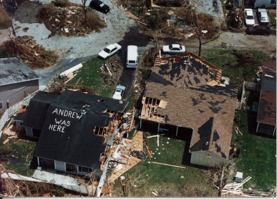
- August 24, 1992- Hurricane AndrewHurricane AndrewHurricane Andrew was the third Category 5 hurricane to make landfall in the United States, after the Labor Day Hurricane of 1935 and Hurricane Camille in 1969. Andrew was the first named storm and only major hurricane of the otherwise inactive 1992 Atlantic hurricane season...
makes landfall on HomesteadHomestead, FloridaHomestead is a city in Miami-Dade County, Florida, United States nestled between Biscayne National Park to the east and Everglades National Park to the west. Homestead is primarily a Miami suburb and a major agricultural area....
, just south of MiamiMiami, FloridaMiami is a city located on the Atlantic coast in southeastern Florida and the county seat of Miami-Dade County, the most populous county in Florida and the eighth-most populous county in the United States with a population of 2,500,625...
, as a Category FiveSaffir-Simpson Hurricane ScaleThe Saffir–Simpson Hurricane Scale , or the Saffir–Simpson Hurricane Wind Scale , classifies hurricanes — Western Hemisphere tropical cyclones that exceed the intensities of tropical depressions and tropical storms — into five categories distinguished by the intensities of their sustained winds...
hurricane with winds of 165 mph (265 km/h). The winds destroy 25,524 homes and damage 101,241 others in southern Florida, leaving up to one-quarter million people temporarily homeless. In Homestead, more than 99% of all mobile homes are completely destroyed. Hurricane Andrew causes $25.5 billion in damage (1992 USD, $39.2 billion 2008 USD) in south Florida and 15 direct deaths. At the time, Andrew is the costliest Atlantic hurricaneAtlantic hurricaneNorth Atlantic tropical cyclones usually form in the northern hemisphere summer or fall. Tropical cyclones can be categorized by intensity. Tropical storms have one-minute maximum sustained winds of at least 39 mph , while hurricanes have one-minute maximum sustained exceeding 74 mph...
in the history of the United States, though has since dropped to second after Hurricane KatrinaHurricane KatrinaHurricane Katrina of the 2005 Atlantic hurricane season was a powerful Atlantic hurricane. It is the costliest natural disaster, as well as one of the five deadliest hurricanes, in the history of the United States. Among recorded Atlantic hurricanes, it was the sixth strongest overall...
. - September 29, 1992- Tropical Storm Earl turns to the north while located off the coast of northeastern Florida, dropping over 7 inches (175 mm) of rain near Lake OkeechobeeLake OkeechobeeLake Okeechobee , locally referred to as The Lake or The Big O, is the largest freshwater lake in the state of Florida. It is the seventh largest freshwater lake in the United States and the second largest freshwater lake contained entirely within the lower 48 states...
.
1993
- June 1, 1993- Tropical Depression OneTropical Depression One (1993)Tropical Depression One was a weak tropical cyclone that struck Cuba and the Bahamas in May and June 1993. It formed in the western Caribbean Sea on May 31 and produced heavy rainfall along its path. In Cuba, the precipitation reached 12.4 inches , which caused widespread flooding and damage...
passes to the southeast of the state, producing heavy rainfall peaking at 9.4 inches (239 mm) in TavernierTavernier, FloridaTavernier is a census-designated place in Monroe County, Florida, on an island named Key Largo in the upper Florida Keys. The population was 2,173 at the 2000 census.-Geography:Tavernier is located at ....
.
1994
- July 3, 1994- Tropical Storm AlbertoTropical Storm Alberto (1994)Tropical Storm Alberto was the first storm of the 1994 Atlantic hurricane season. It hit Florida across the Southeast United States in July, causing a massive flooding disaster while stalling over Georgia and Alabama. Alberto caused $1 billion in damage and 30 deaths.-Meteorological history:A...
makes landfall near DestinDestin, FloridaDestin is a city located in Okaloosa County, Florida. It is a principal city of the Fort Walton Beach-Crestview-Destin, Florida Metropolitan Statistical Area.Located on Florida's Emerald Coast, Destin is known for its white beaches and emerald green waters...
, dropping moderate rainfall across the state including over 20 inches (500 mm) along the Florida PanhandleFlorida PanhandleThe Florida Panhandle, an informal, unofficial term for the northwestern part of Florida, is a strip of land roughly 200 miles long and 50 to 100 miles wide , lying between Alabama on the north and the west, Georgia also on the north, and the Gulf of Mexico to the south. Its eastern boundary is...
. Heavy rainfall throughout the area results in extensive flooding, with the ApalachicolaApalachicola RiverThe Apalachicola River is a river, approximately 112 mi long in the State of Florida. This river's large watershed, known as the ACF River Basin for short, drains an area of approximately into the Gulf of Mexico. The distance to its farthest headstream in northeast Georgia is approximately 500...
and Chipola RiverChipola RiverThe Chipola River is a tributary of the Apalachicola River in Florida. The river crosses Jackson, Calhoun and Gulf counties. The river flows into the Dead Lakes State Recreation Area just before reaching the Apalachicola. The Dead Lakes were formed when the Apalachicola deposited sand bars...
s exceeding a 100-year flood100-year floodA one-hundred-year flood is calculated to be the level of flood water expected to be equaled or exceeded every 100 years on average. The 100-year flood is more accurately referred to as the 1% annual exceedance probability flood, since it is a flood that has a 1% chance of being equaled or exceeded...
event. 300,000 chickens and 90% of the oyster crop in Apalachicola BayApalachicola BayApalachicola Bay is an estuary and lagoon located on Florida's northwest coast renowned for its oysters. The Apalachicola Bay system also includes St. Georges Sound, St. Vincent Sound and East Bay, covering an area of about . Four islands St. Vincent Island to the west, Cape St. George Island and St...
perish. Damage in Florida totals $80 million (1994 USD, $116 million 2008 USD)). - August 15, 1994- Tropical Storm BerylTropical Storm Beryl (1994)Tropical Storm Beryl, was the second named storm of the 1994 Atlantic hurricane season. Beryl originated north of Puerto Rico as an upper-level low pressure system, then passed over Florida, then entered the gulf where it became a tropical depression. The storm had advisories on it for five days;...
strikes Panama CityPanama City, Florida-Personal income:The median income for a household in the city was $31,572, and the median income for a family was $40,890. Males had a median income of $30,401 versus $21,431 for females. The per capita income for the city was $17,830...
, producing moderate rainfall reaching a maximum of 10.69 inches (272 mm) in ApalachicolaApalachicola, FloridaApalachicola is a city in Franklin County, Florida, on US 98 about southwest of Tallahassee. The population was 2,334 at the 2000 census. The 2005 census estimated the city's population at 2,340...
. The storm results in $6.9 million in damage (1994 USD, $10 million 2008 USD). - October 2, 1994- The remnants of Tropical Depression TenTropical Depression Ten (1994)Tropical Depression Ten was tenth tropical cyclone of the inactive 1994 Atlantic hurricane season. The circulation of Tropical Depression Ten originated after Tropical Depression Eight had moved over Central America and dissipated. Before it ultimately emerged into the Caribbean Sea and developed...
produces rough seas and heavy rainfall, flooding roads and homes in western Florida. Damage totals $5 million (1994 USD, $7.3 million 2008 USD). - November 16, 1994- Tropical Storm GordonHurricane Gordon (1994)Hurricane Gordon was a long-lived and erratic late-season hurricane of the 1994 Atlantic hurricane season. The twelfth and final tropical cyclone of the season, Gordon formed in the southwestern Caribbean on November 8 after two tropical waves enhanced convection around in area of disturbed...
makes landfall near Fort MyersFort Myers, FloridaFort Myers is the county seat and commercial center of Lee County, Florida, United States. Its population was 62,298 in the 2010 census, a 29.23 percent increase over the 2000 figure....
. The storm drops heavy rainfall across the southern portion of the state, including over 16 inches (406 mm) in Broward CountyBroward County, Florida-2000 Census:As of the census of 2000, there were 1,623,018 people, 654,445 households, and 411,645 families residing in the county. The population density was 1,346 people per square mile . There were 741,043 housing units at an average density of 615 per square mile...
. The rainfall results in heavy agricultural damage, and throughout the state Gordon causes 8 casualties and around $400 million in damage (1994 USD, $582 million 2008 USD).
1995

- June 5, 1995- Tropical Storm AllisonHurricane Allison (1995)Hurricane Allison was the first named storm and first hurricane of the 1995 Atlantic hurricane season. It was an early season hurricane that delivered heavy rains and caused minor damage, primarily across Cuba, Florida and Georgia....
first strikes near Alligator PointAlligator Point, FloridaAlligator Point is an unincorporated community in Franklin County, Florida, United States. It is located along US 98, south of Bald Point State Park. , on the Gulf of Mexico. Alligator Point is a small beach community made up of mostly beach homes and the...
and later near Saint Marks. Allison produces a 6.8 foot (2 m) storm surgeStorm surgeA storm surge is an offshore rise of water associated with a low pressure weather system, typically tropical cyclones and strong extratropical cyclones. Storm surges are caused primarily by high winds pushing on the ocean's surface. The wind causes the water to pile up higher than the ordinary sea...
in Apalachee BayApalachee BayApalachee Bay is a bay in the northeastern Gulf of Mexico occupying an indentation of the Florida coast to the west of where the Florida peninsula joins the United States mainland. It is bordered by Taylor, Jefferson, Wakulla and Franklin counties. The Aucilla, Econfina, St. Marks and Ochlocknee...
as well as scattered tornadoes, with damage amounting to $860,000 (1995 USD, $1.2 million 2008 USD). - July 27, 1995- The precursor disturbance to Tropical Storm DeanTropical Storm Dean (1995)Tropical Storm Dean was a short-lived storm that formed in late July and lasted into early August. It was the fourth named storm of the 1995 Atlantic hurricane season. It spent most of its life as a tropical depression, and briefly gained tropical storm status before its landfall on the Texas coast...
produces over 5 inches (125 mm) of precipitation in portions of western Florida. - August 2, 1995- Hurricane ErinHurricane Erin (1995)Hurricane Erin was the fifth named tropical cyclone and the second hurricane of the unusually active 1995 Atlantic hurricane season. Erin began as a tropical wave off the west coast of Africa on July 22, and crossed the Atlantic ocean without ever developing. On July 31, the last day of the month,...
strikes near Vero BeachVero Beach, FloridaVero Beach is a city in Indian River County, Florida, USA. According to the U.S. Census Bureau's 2006 estimates, the city had a population of 16,939. It is the county seat of Indian River County...
and days later near Fort Walton BeachFort Walton Beach, FloridaFort Walton Beach is a city in southern Okaloosa County, Florida, United States. As of 2005, the population estimate for Fort Walton Beach was 19,992, and as of 2010, the population estimate for Fort Walton Beach is 19,507 recorded by the U.S. Census Bureau...
, producing moderate rainfall including totals of 10.14 inches (258 mm) in MelbourneMelbourne, FloridaMelbourne is a city in Brevard County, Florida, United States. As of 2009, the population estimated by the U.S. Census Bureau is 78,323. The municipal area is the second largest by size and by population in the county. Melbourne is a principal city of the Palm Bay – Melbourne – Titusville, Florida...
and 20 inches (560 mm) in DeFuniak Springs on the Florida PanhandleFlorida PanhandleThe Florida Panhandle, an informal, unofficial term for the northwestern part of Florida, is a strip of land roughly 200 miles long and 50 to 100 miles wide , lying between Alabama on the north and the west, Georgia also on the north, and the Gulf of Mexico to the south. Its eastern boundary is...
. Thousands of homes are damaged near the hurricane's two landfalls, with monetary damage totaling about $700 million (1995 USD, $990 million 2008 USD). Rip currents kill a surfer off Palm Beach CountyPalm Beach County, FloridaPalm Beach County is the largest county in the state of Florida in total area, and third in population. As of 2010, the county's estimated population was 1,320,134, making it the twenty-eighth most populous in the United States...
, and two people die in the Gulf of MexicoGulf of MexicoThe Gulf of Mexico is a partially landlocked ocean basin largely surrounded by the North American continent and the island of Cuba. It is bounded on the northeast, north and northwest by the Gulf Coast of the United States, on the southwest and south by Mexico, and on the southeast by Cuba. In...
when their boat capsizes. - August 23, 1995- Tropical Storm JerryTropical Storm Jerry (1995)Tropical Storm Jerry was a tropical storm that caused severe flooding throughout the southeast United States in August of the 1995 Atlantic hurricane season...
makes landfall near JupiterJupiter, FloridaJupiter is a town located in Palm Beach County, Florida. As of the 2000 census, the town had a total population of 39,328. The estimate population for 2009 is 50,606. As of 2006, the population had grown to 50,028, according to the University of Florida, Bureau of Economic and Business Research....
and drops heavy rainfall throughout the state which peaks at 16.8 inches (427 mm) near NaplesNaples, FloridaNaples is a city in Collier County, Florida, United States. As of July 1, 2007, the U.S. Census Bureau estimated the city's population at 21,653. Naples is a principal city of the Naples–Marco Island Metropolitan Statistical Area, which had an estimated total population of 315,839 on July 1, 2007...
. Freshwater flooding from the rainfall damages 340 homes in Collier CountyCollier County, FloridaCollier County is a county located in the U.S. state of Florida. As of 2000, the population was 251,377. The U.S. Census Bureau 2007 estimate for the county is 315,839...
, with damage amounting to $20.5 million (1995 USD, $29 million 2008 USD). - October 4, 1995- Hurricane OpalHurricane OpalHurricane Opal was a Category 4 hurricane that formed in the Gulf of Mexico in September 1995.Opal was the ninth hurricane and the strongest of the abnormally active 1995 Atlantic hurricane season...
hits Pensacola BeachPensacola Beach, FloridaPensacola Beach is an unincorporated community located on Santa Rosa Island, a barrier island, in Escambia County, Florida, United States. It is situated south of Pensacola, and Gulf Breeze connected via bridges spanning to the Fairpoint Peninsula and then to the island, on the Gulf of Mexico...
with winds of 115 mph (185 km/h). The hurricane drops moderate rainfall across much of the state, and a tornado spawned by Opal kills one person — the only direct casualty in the state from the hurricane. Strong winds and rough seas damage or destroy large portions of coastal towns along the Florida PanhandleFlorida PanhandleThe Florida Panhandle, an informal, unofficial term for the northwestern part of Florida, is a strip of land roughly 200 miles long and 50 to 100 miles wide , lying between Alabama on the north and the west, Georgia also on the north, and the Gulf of Mexico to the south. Its eastern boundary is...
, with serious damage extending eastward to Apalachicola. At the time, Opal is the third costliest tropical cyclone in the United States, with damage totaling over $1 billion (1995 USD, $1.4 billion 2008 USD) in Florida.
1996
- July 11, 1996- Hurricane BerthaHurricane Bertha (1996)Hurricane Bertha was a strong, early season major hurricane which impacted areas from the Leeward Islands to Atlantic Canada. Bertha originated from a tropical wave which moved off the eastern coast of Africa in early July. By July 3, an area of low pressure developed along the wave...
parallels the east coast of Florida about 175 miles (280 km) offshore, producing a storm tideStorm tideA storm tide is a tide with a high flood period caused by a storm. Storm tides can be a severe danger to the coast and the people living along the coast. The water level can rise to more than 5 meters above the normal tide....
of 2 feet (0.6 m) at Jacksonville BeachJacksonville Beach, FloridaJacksonville Beach is a city on the Atlantic coast of Duval County, Florida, east of Jacksonville. It is part of the Jacksonville Beaches community, together with Mayport, Atlantic Beach, Neptune Beach, and Ponte Vedra Beach...
, as well as rip currents along the coast. Two people drown in rip currents in Miami BeachMiami Beach, FloridaMiami Beach is a coastal resort city in Miami-Dade County, Florida, United States, incorporated on March 26, 1915. The municipality is located on a barrier island between the Atlantic Ocean and Biscayne Bay, the latter which separates the Beach from Miami city proper...
, and one pilot dies indirectly due to the storm when an evacuating military jet crashes into a house. - September 2, 1996- Large swells from Hurricane FranHurricane FranHurricane Fran was a powerful Cape Verde-type hurricane of the 1996 Atlantic hurricane season that made landfall near Cape Fear in North Carolina at Category 3 strength. Throughout the eastern United States, early statistics on Fran reported 27 deaths and $3.2 billion in damage...
in the open Atlantic OceanAtlantic OceanThe Atlantic Ocean is the second-largest of the world's oceanic divisions. With a total area of about , it covers approximately 20% of the Earth's surface and about 26% of its water surface area...
knock five people out of a fishing boat off Jupiter Inlet; all are rescued. - October 8, 1996- Tropical Storm JosephineTropical Storm Josephine (1996)Tropical Storm Josephine was the tenth named storm of a moderately active 1996 Atlantic hurricane season. A strong tropical storm, Josephine dumped heavy rain across most of the southeastern and eastern United States killing two people and leaving $130 million dollars in...
strikes the eastern portion of Apalachicola BayApalachicola BayApalachicola Bay is an estuary and lagoon located on Florida's northwest coast renowned for its oysters. The Apalachicola Bay system also includes St. Georges Sound, St. Vincent Sound and East Bay, covering an area of about . Four islands St. Vincent Island to the west, Cape St. George Island and St...
with winds of 70 mph (115 km/h), producing a peak storm tide of 9.3 feet (2.8 m) in SuwanneeSuwannee, FloridaSuwannee is an unincorporated community in Dixie County, Florida, United States. It is located on the Suwannee River near its mouth, at the southern end of the Big Bend region of Florida. It is 23 miles south west of Old Town, to which it is connected by County Road 349.Suwannee is a fishing...
and spawning at least 16 tornadoes. A tornado in EdgewaterEdgewater, FloridaEdgewater is the name of some places in the U.S. state of Florida:*Edgewater, Broward County, Florida*Edgewater, Volusia County, Florida*Edgewater , a neighborhood within the City of Miami...
severely damages 30 houses, with the storm surge resulting in widespread coastal flooding. - October 18, 1996- Hurricane LiliHurricane Lili (1996)Hurricane Lili was a relatively long-lived hurricane during the very active 1996 Atlantic hurricane season. Lili formed on October 14 from a tropical wave, which emerged from the coast of west Africa on October 4. The tropical wave which developed into Lili was slow to form due to unfavorable wind...
moves northeastward to the south of the state after striking CubaCubaThe Republic of Cuba is an island nation in the Caribbean. The nation of Cuba consists of the main island of Cuba, the Isla de la Juventud, and several archipelagos. Havana is the largest city in Cuba and the country's capital. Santiago de Cuba is the second largest city...
, dropping moderate rainfall including a maximum of 12.08 inches (307 mm) in southeastern Florida.
1997
- July 19, 1997- Hurricane DannyHurricane Danny (1997)Hurricane Danny was the only hurricane to make landfall in the United States during the 1997 Atlantic hurricane season, and the second hurricane and fourth tropical storm of the season...
hits near Mullet Point, Alabama, producing tropical storm force winds and moderate rainfall peaking at 6.78 inches (172 mm) in PensacolaPensacola, FloridaPensacola is the westernmost city in the Florida Panhandle and the county seat of Escambia County, Florida, United States of America. As of the 2000 census, the city had a total population of 56,255 and as of 2009, the estimated population was 53,752...
.
1998
- September 3, 1998- Hurricane EarlHurricane Earl (1998)Hurricane Earl was an atypical, short-lived Category 2 hurricane that caused moderate damage throughout the Southeast United States. It formed out of a poorly organized tropical disturbance over the southwest Gulf of Mexico late on August 31, 1998...
makes landfall near Panama CityPanama City, Florida-Personal income:The median income for a household in the city was $31,572, and the median income for a family was $40,890. Males had a median income of $30,401 versus $21,431 for females. The per capita income for the city was $17,830...
, resulting in an estimated storm surgeStorm surgeA storm surge is an offshore rise of water associated with a low pressure weather system, typically tropical cyclones and strong extratropical cyclones. Storm surges are caused primarily by high winds pushing on the ocean's surface. The wind causes the water to pile up higher than the ordinary sea...
of around 8 feet (2.4 m) and moderate to heavy rainfall peaking at 16.38 inches (416 mm) where it struck land. Two people die as a result of a boat being capsized off Panama City, and damage in Florida totals $70 million (1998 USD, $93 million 2008 USD). - September 20, 1998- The outer rainbandRainbandA rainband is a cloud and precipitation structure associated with an area of rainfall which is significantly elongated. Rainbands can be stratiform or convective, and are generated by differences in temperature. When noted on weather radar imagery, this precipitation elongation is referred to as...
s of Tropical Storm HermineTropical Storm Hermine (1998)Tropical Storm Hermine was the eighth tropical cyclone and named storm of the 1998 Atlantic hurricane season. Hermine developed from a tropical wave that emerged from the west coast of Africa on September 5. The wave moved westward across the Atlantic Ocean, and on entering the northwest Caribbean...
produce moderate amounts of rainfall throughout the state, peaking at 14.14 inches (359 mm) in Fort LauderdaleFort Lauderdale, FloridaFort Lauderdale is a city in the U.S. state of Florida, on the Atlantic coast. It is the county seat of Broward County. As of the 2010 census, the city had a population of 165,521. It is a principal city of the South Florida metropolitan area, which was home to 5,564,635 people at the 2010...
. - September 25, 1998- Hurricane GeorgesHurricane GeorgesHurricane Georges was a very destructive, powerful and long-lived Cape Verde-type Category 4 hurricane. Georges was the seventh tropical storm, fourth hurricane, and second major hurricane of the 1998 Atlantic hurricane season...
passes over Key WestKey West, FloridaKey West is a city in Monroe County, Florida, United States. The city encompasses the island of Key West, the part of Stock Island north of U.S. 1 , Sigsbee Park , Fleming Key , and Sunset Key...
as a Category 2 hurricane, and days later it moves eastward through the Florida PanhandleFlorida PanhandleThe Florida Panhandle, an informal, unofficial term for the northwestern part of Florida, is a strip of land roughly 200 miles long and 50 to 100 miles wide , lying between Alabama on the north and the west, Georgia also on the north, and the Gulf of Mexico to the south. Its eastern boundary is...
after hitting Biloxi, MississippiBiloxi, MississippiBiloxi is a city in Harrison County, Mississippi, in the United States. The 2010 census recorded the population as 44,054. Along with Gulfport, Biloxi is a county seat of Harrison County....
. In the Florida KeysFlorida KeysThe Florida Keys are a coral archipelago in southeast United States. They begin at the southeastern tip of the Florida peninsula, about south of Miami, and extend in a gentle arc south-southwest and then westward to Key West, the westernmost of the inhabited islands, and on to the uninhabited Dry...
, the hurricane produced 8.41 inches (214 mm) of rain in TavernierTavernier, FloridaTavernier is a census-designated place in Monroe County, Florida, on an island named Key Largo in the upper Florida Keys. The population was 2,173 at the 2000 census.-Geography:Tavernier is located at ....
and wind gusts peaking at 110 mph (177 km/h) in MarathonMarathon, FloridaMarathon is a city on Knight's Key, Boot Key, Key Vaca, Fat Deer Key, Long Point Key, Crawl Key and Grassy Key islands in the middle Florida Keys, in Monroe County, Florida, in the United States. As of the 2000 census, the city had a total population of 10,255. As of 2005, the population estimated...
. There, Georges damages 1,363 homes and destroys 173 houses, with damage amounting to $270 million (1998 USD, $357 million 2008 USD) in the Keys. In the Florida Panhandle, the storm drops 38.46 inches (977 mm) of rain in Munson and results in $70 million in damage (1998 USD, $93 million 2008 USD). - November 5, 1998- Tropical Storm MitchHurricane MitchHurricane Mitch was the most powerful hurricane and the most destructive of the 1998 Atlantic hurricane season, with maximum sustained winds of 180 mph . The storm was the thirteenth tropical storm, ninth hurricane, and third major hurricane of the season. Along with Hurricane Georges, Mitch...
makes landfall near NaplesNaples, FloridaNaples is a city in Collier County, Florida, United States. As of July 1, 2007, the U.S. Census Bureau estimated the city's population at 21,653. Naples is a principal city of the Naples–Marco Island Metropolitan Statistical Area, which had an estimated total population of 315,839 on July 1, 2007...
and drops up to 11.2 inches (284 mm) of rainfall in Boca RatonBoca Raton, FloridaBoca Raton is a city in Palm Beach County, Florida, USA, incorporated in May 1925. In the 2000 census, the city had a total population of 74,764; the 2006 population recorded by the U.S. Census Bureau was 86,396. However, the majority of the people under the postal address of Boca Raton, about...
. The storm spawns five tornadoes, injuring 65 people and damaging or destroying 645 homes. Two people die in Monroe CountyMonroe County, FloridaMonroe County is a county located in the state of Florida. As of 2000, the population was 79,589. The U.S. Census Bureau 2006 estimate for the county was 74,737....
when their respective fishing boats capsize, and damage in the state amounts to $40 million (1998 USD, $53 million 2008 USD).
1999
- August 29, 1999- High surf from Hurricane DennisHurricane Dennis (1999)Hurricane Dennis was an Atlantic hurricane that affected the Bahamas and parts of the Mid-Atlantic and Northeast during the 1999 Atlantic hurricane season. The fifth tropical cyclone, fourth tropical storm, and third hurricane of the season, Dennis originated from a tropical wave that passed north...
paralleling the east coast of Florida causes four fatalities. - September 15, 1999- Once predicted to make a landfall on the state as a major hurricane, Hurricane FloydHurricane FloydHurricane Floyd was the sixth named storm, fourth hurricane, and third major hurricane in the 1999 Atlantic hurricane season. Floyd triggered the third largest evacuation in US history when 2.6 million coastal residents of five states were ordered from their homes as it approached...
parallels the eastern coastline about 115 miles (185 km) offshore. At least 330 homes are damaged by fallen trees, and rough surf results in heavy beach erosion. Monetary damage totals $61 million (1999 USD, $79 million 2008 USD). - September 21, 1999- Tropical Storm HarveyTropical Storm Harvey (1999)Tropical Storm Harvey was a moderately strong tropical storm that caused extensive flooding across south Florida during the 1999 Atlantic hurricane season. The eleventh named storm and second tropical cyclone of the season, Harvey developed from a tropical wave in the Gulf of Mexico on September 19...
strikes Everglades City with a storm surge of over 2 feet (0.6 m). The storm drops over 10 inches (250 mm) of rain, flooding several homes. Damage from Harvey totals $15 million (1999 USD, $19 million 2008 USD). - October 15, 1999- Hurricane IreneHurricane Irene (1999)Hurricane Irene was a hurricane that produced somewhat heavy damage across southern Florida during the 1999 Atlantic hurricane season. The ninth tropical storm and the sixth hurricane of the season, Irene developed in the western Caribbean Sea on October 13 from a tropical wave. It moved northward,...
makes landfall on Key WestKey West, FloridaKey West is a city in Monroe County, Florida, United States. The city encompasses the island of Key West, the part of Stock Island north of U.S. 1 , Sigsbee Park , Fleming Key , and Sunset Key...
and later Cape Sable, producing heavy rainfall peaking at 17.45 inches (443 mm) in Boynton BeachBoynton Beach, FloridaBoynton Beach is a city in Palm Beach County, Florida, United States. The population was 60,389 at the 2000 census. As of 2006, the city had a population of 66,714 according to the University of Florida, Bureau of Economic and Business Research...
. The rainfall led to flooding which isolated thousands. Five people are electrocuted from the floodwaters, and three people drown when driving into flooded canals. Damage in the state amounts to $800 million (1999 USD, $1 billion 2008 USD).
Monthly statistics
| Month | Number of recorded storms affecting Florida |
|---|---|
| May | 3 |
| June | 11 |
| July | 8 |
| August | 17 |
| September | 21 |
| October | 14 |
| November | 8 |
Deadly storms
The following is a list of hurricanes with known deaths in Florida between 1975 and 1999.| Name | Year | Number of deaths |
|---|---|---|
| Andrew Hurricane Andrew Hurricane Andrew was the third Category 5 hurricane to make landfall in the United States, after the Labor Day Hurricane of 1935 and Hurricane Camille in 1969. Andrew was the first named storm and only major hurricane of the otherwise inactive 1992 Atlantic hurricane season... |
1992 | 15 |
| Gordon Hurricane Gordon (1994) Hurricane Gordon was a long-lived and erratic late-season hurricane of the 1994 Atlantic hurricane season. The twelfth and final tropical cyclone of the season, Gordon formed in the southwestern Caribbean on November 8 after two tropical waves enhanced convection around in area of disturbed... |
1994 | 8 |
| David Hurricane David Hurricane David was the fourth named tropical cyclone, second hurricane, and first major hurricane of the 1979 Atlantic hurricane season. A Category 5 hurricane on the Saffir-Simpson Hurricane Scale, David was among the deadliest hurricanes in the latter half of the 20th century, killing... |
1979 | 5 |
| Dennis Hurricane Dennis (1999) Hurricane Dennis was an Atlantic hurricane that affected the Bahamas and parts of the Mid-Atlantic and Northeast during the 1999 Atlantic hurricane season. The fifth tropical cyclone, fourth tropical storm, and third hurricane of the season, Dennis originated from a tropical wave that passed north... |
1999 | 4 |
| Unnamed Subtropical Storm One (1982) The 1982 Florida subtropical storm, officially known as Subtropical Storm One, was the only subtropical cyclone of the inactive 1982 Atlantic hurricane season. The storm originated from two different systems around the Gulf of Mexico and Caribbean Sea on June 16. The systems merged into trough... |
1982 | 3 |
| Kate Hurricane Kate (1985) Hurricane Kate was the sixth hurricane to hit the United States during the 1985 Atlantic hurricane season, tying a record. Forming late in the season, it killed 15 people and caused $530 million in damage on its long path through Cuba, Florida, and Georgia between November 18 and... |
1985 | 3 |
| Erin Hurricane Erin (1995) Hurricane Erin was the fifth named tropical cyclone and the second hurricane of the unusually active 1995 Atlantic hurricane season. Erin began as a tropical wave off the west coast of Africa on July 22, and crossed the Atlantic ocean without ever developing. On July 31, the last day of the month,... |
1995 | 3 |
| Bertha Hurricane Bertha (1990) Hurricane Bertha was a Category 1 tropical cyclone that formed in late July and lasted though early August of the 1990 Atlantic hurricane season. The second named storm and first hurricane of the 1990 season, Bertha formed as a subtropical cyclone on July 24 and moved southward where it gained... |
1990 | 2 |
| Unnamed Tropical Depression One (1992) Tropical Depression One in June 1992 produced 100-year floods in portions of southwestern Florida. The first tropical depression and second tropical cyclone of the 1992 Atlantic hurricane season, the depression developed on June 25 from a tropical wave... |
1992 | 2 |
| Bertha Hurricane Bertha (1996) Hurricane Bertha was a strong, early season major hurricane which impacted areas from the Leeward Islands to Atlantic Canada. Bertha originated from a tropical wave which moved off the eastern coast of Africa in early July. By July 3, an area of low pressure developed along the wave... |
1996 | 2 (1 indirect) |
| Earl Hurricane Earl (1998) Hurricane Earl was an atypical, short-lived Category 2 hurricane that caused moderate damage throughout the Southeast United States. It formed out of a poorly organized tropical disturbance over the southwest Gulf of Mexico late on August 31, 1998... |
1998 | 2 |
| Mitch Hurricane Mitch Hurricane Mitch was the most powerful hurricane and the most destructive of the 1998 Atlantic hurricane season, with maximum sustained winds of 180 mph . The storm was the thirteenth tropical storm, ninth hurricane, and third major hurricane of the season. Along with Hurricane Georges, Mitch... |
1998 | 2 |
| Frederic Hurricane Frederic Hurricane Frederic was the sixth tropical cyclone, third hurricane and second major hurricane of the 1979 Atlantic hurricane season. Frederic was the costliest hurricane to ever hit the U.S. Gulf Coast at that particular time... |
1979 | 1 |
| Isidore | 1984 | 1 |
| Opal Hurricane Opal Hurricane Opal was a Category 4 hurricane that formed in the Gulf of Mexico in September 1995.Opal was the ninth hurricane and the strongest of the abnormally active 1995 Atlantic hurricane season... |
1995 | 1 |
| Irene Hurricane Irene (1999) Hurricane Irene was a hurricane that produced somewhat heavy damage across southern Florida during the 1999 Atlantic hurricane season. The ninth tropical storm and the sixth hurricane of the season, Irene developed in the western Caribbean Sea on October 13 from a tropical wave. It moved northward,... |
1999 | 0 (8 indirect) |