
.gif)
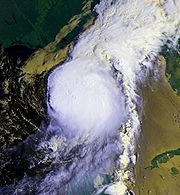
Hurricane Florence (1988)
Encyclopedia
Hurricane Florence was the third of four named tropical cyclones
to make landfall
on the United States
during the 1988 Atlantic hurricane season
. The seventh tropical storm and second hurricane of the season, Florence developed on September 7 from an area of convection associated with a dissipating frontal
trough
in the southern Gulf of Mexico
. After initially moving eastward, the storm turned northward and strengthened. Florence reached hurricane status and later peak winds of 80 mph (130 km/h) on September 9 shortly before striking southeastern Louisiana
. The storm rapidly weakened over land and dissipated on September 11 over northeastern Texas
.
Early in its duration, the storm dropped rainfall across the Yucatán Peninsula
. Upon striking Louisiana
, Florence produced a moderate storm surge
, causing severe beach erosion in some locations. Gusty winds were also reported, causing power outages to over 100,000 people. In Alabama
, one man died while trying to secure his boat. Rainfall from the hurricane caused severe river flooding in portions of the Florida Panhandle
in an area already severely affected by heavy rainfall; the flooding damaged or destroyed dozens of houses in Santa Rosa County
. Throughout its path, damage totaled about $2.9 million (1988 USD, $5.3 million 2008 USD).
exited the coast of Texas
into the Gulf of Mexico
. A convective
band from the front continued southeastward and stalled between Veracruz, Mexico
and Tampa, Florida
. The band began to split into two on September 6; the northeastern portion developed into a frontal wave and tracked northeastward, while the southwestern portion remained nearly stationary and began showing signs of tropical organization
. Located in an area of generally low pressures
, the system developed a spiral band structure, though deep convection was mostly intermittent. Subsequent to the formation of a surface circulation, the system developed into a tropical depression while located about 450 miles (725 km) northwest of Mérida, Yucatán
.
 The depression drifted eastward under the influence of the dissipating frontal trough
, and intensified into Tropical Storm Florence to the north of the Yucatán Peninsula
, as confirmed by Hurricane Hunters
. Initially, the center was located to the north of the deep convection, with only one weak rainband to the north of the circulation. However, subsequent to a drop in vertical wind shear
, an increase in moisture, and increase in upper-level outflow, deep convection greatly increased and organized over the circulation early on September 9. As the trough dissipated and a ridge
built northwestward behind it, steering currents became weak, leaving Florence temporarily stationary. Later on September 9, the influence of a mid- to upper-level trough to its north caused Florence to accelerate northward. Steadily intensifying, Florence attained hurricane status about 100 miles (165 km) south of the mouth of the Mississippi River
. The hurricane intensified slightly further, and struck the western Mississippi River Delta
with winds of 80 mph (130 km/h) at 0200 UTC
on September 10. Upon making landfall, dry air became entrained in the circulation, and Florence rapidly weakened over southeastern Louisiana
. By the time it passed over New Orleans and Lake Ponchartrain most convection had dissipated, and about ten hours after making landfall
Florence degenerated into a tropical depression. The system subsequently crossed over southwestern Mississippi
as it turned northwestward, and later entered northern Louisiana
before dissipating over northeastern Texas
on September 11. The mid-level circulation turned northeastward through the central United States before dissipating over Ohio
on September 13.
issued a hurricane watch
from Port Arthur, Texas
to Pensacola, Florida
. Three hours later, the watch was upgraded to a hurricane warning from Pensacola to Cameron, Louisiana
, with a tropical storm warning issued from Pensacola eastward to Apalachicola, Florida
. Around the time of Florence moving ashore, the National Hurricane Center limited the hurricane warning from Pensacola, Florida to Morgan City, Louisiana
. Hours after the hurricane made landfall, the warning was replaced by a tropical storm warning from Mobile, Alabama
to Grand Isle, Louisiana
, which was discontinued two hours later.
Prior to the arrival of the hurricane, an estimated 20,000 people evacuated the coastal parishes of southeastern Louisiana
, including nearly all of the 2,000 residents on Grand Isle
. Small-scale evacuations were issued for residents living in low-lying or coastal areas of Mississippi
and Alabama
. Offshore, the threat of the hurricane prompted oil companies to evacuate employees on oil rigs to the mainland.
The threat of the hurricane caused Democratic presidential nominee Michael Dukakis
to cancel a rally and two fund-raising events in New Orleans. Governor Buddy Roemer
issued for the Louisiana National Guard
to be on standby for emergency duty. Officials closed several bridges across southeastern Louisiana and also canceled ferry travel across Lake Ponchartrain. In Pensacola, Florida
, the Navy base
moved the USS Lexington
into the Gulf of Mexico
during the hurricane, and also sent more than 100 aircraft to a base in Ohio
.
 The primary rainband extending southward from the circulation of Florence dropped moderate rainfall across the Yucatán Peninsula
and through southern Mexico
. Rainfall amounts peaked at 10.79 inches (274 mm) in San Baltazar Loxicha, Guerrero, with 10.67 inches (271 mm) reported in southeastern Chiapas
and 9.74 inches (247 mm) near Merida
. Damage, if any, is unknown.
Upon making landfall on Louisiana
, Hurricane Florence produced higher than normal tides
, including a peak observation of 7.5 feet (2.3 m) above mean sea level on the Bayou Benvenue to the east of New Orleans. Rainfall was relatively light, ranging from about 1 inch (25 mm) to a maximum of 4.05 inches (103 mm) at Watson
. Winds of tropical storm force occurred across southeastern Louisiana, with wind gusts peaking at 64 mph (103 km/h) at an automatic Coast Guard Station
on the Southwest Pass of the Mississippi River Delta
. An unofficial tornado was reported in Tangipahoa Parish
. Minor storm surge
flooding occurred outside of the levee
system of southern Louisiana
in Plaquemines
, Saint Bernard, and Saint Tammany Parishes. On Grand Isle
, strong wave action resulted in significant beach erosion, with most areas on the island losing about 40 feet (12.2 m) of beach. The storm surge also flooded a portion of Louisiana Highway 300
near Delacroix. The passage of the hurricane broke a levee in Delacroix; it was quickly repaired with flooding from the levee being pumped to the gulf. Light to moderate damage was reported across the southeastern portion of the state, primarily from falling trees. The winds also downed numerous power lines, leaving about 150,000 people without power for some period of time during the storm. The power outages were short-lived, with about 6,900 left without power by the day after the hurricane. Damage in the state was fairly minor, totaling about $2.5 million (1988 USD, $4.4 million 2007 USD).
Rainfall from Florence reached over 7 inches (178 mm) at one location in southeastern Mississippi
, while a station 3 miles (4.8 km) south-southeast of Brewton, Alabama
reported a storm-wide peak rainfall total of 10.67 inches (271 mm). Despite the rainfall, no damage was reported in Alabama or Mississippi. In Mobile Bay
in Alabama, one man died while attempting to secure his boat — the only direct fatality related to the hurricane.
Heavy rainfall was reported along the Florida Panhandle
, peaking at over 10 inches (254 mm) in the extreme northwestern portion of the state. The rainfall caused the worst flooding in ten years, and resulted in additional flooding to the already swollen Coldwater Creek and Blackwater River
in Santa Rosa County
. Near the river, 30 homes were destroyed with an additional 50 houses damaged, totaling about $320,000 (1988 USD, $560,000 2007 USD) in damage. Several roads were closed from the flooding, as well. The strong convective band associated with Florence extended across the Florida Panhandle, spawning nine tornadoes in Walton County
and one waterspout in Bay County
. Damage from the tornadoes amounted to about $100,000 (1988 USD, $175,000 2007 USD).
The remnant circulation of Florence produced light to moderate rainfall across the Ohio Valley and central United States
. Precipitation reached over 3 inches (75 mm) in extreme southeastern Missouri
, southern Illinois
, and central Ohio
, and extended as far northward as Michigan
.
Atlantic hurricane
North Atlantic tropical cyclones usually form in the northern hemisphere summer or fall. Tropical cyclones can be categorized by intensity. Tropical storms have one-minute maximum sustained winds of at least 39 mph , while hurricanes have one-minute maximum sustained exceeding 74 mph...
to make landfall
Landfall (meteorology)
Landfall is the event of a tropical cyclone or a waterspout coming onto land after being over water. When a waterspout makes landfall it is reclassified as a tornado, which can then cause damage inland...
on the United States
United States
The United States of America is a federal constitutional republic comprising fifty states and a federal district...
during the 1988 Atlantic hurricane season
1988 Atlantic hurricane season
The 1988 Atlantic hurricane season was a moderately active season that proved costly and deadly, with 15 tropical cyclones directly affecting land. The season officially began on June 1, 1988, and lasted until November 30, 1988, although activity began on May 30 when a tropical...
. The seventh tropical storm and second hurricane of the season, Florence developed on September 7 from an area of convection associated with a dissipating frontal
Surface weather analysis
Surface weather analysis is a special type of weather map that provides a view of weather elements over a geographical area at a specified time based on information from ground-based weather stations...
trough
Trough (meteorology)
A trough is an elongated region of relatively low atmospheric pressure, often associated with fronts.Unlike fronts, there is not a universal symbol for a trough on a weather chart. The weather charts in some countries or regions mark troughs by a line. In the United States, a trough may be marked...
in the southern Gulf of Mexico
Gulf of Mexico
The Gulf of Mexico is a partially landlocked ocean basin largely surrounded by the North American continent and the island of Cuba. It is bounded on the northeast, north and northwest by the Gulf Coast of the United States, on the southwest and south by Mexico, and on the southeast by Cuba. In...
. After initially moving eastward, the storm turned northward and strengthened. Florence reached hurricane status and later peak winds of 80 mph (130 km/h) on September 9 shortly before striking southeastern Louisiana
Louisiana
Louisiana is a state located in the southern region of the United States of America. Its capital is Baton Rouge and largest city is New Orleans. Louisiana is the only state in the U.S. with political subdivisions termed parishes, which are local governments equivalent to counties...
. The storm rapidly weakened over land and dissipated on September 11 over northeastern Texas
Texas
Texas is the second largest U.S. state by both area and population, and the largest state by area in the contiguous United States.The name, based on the Caddo word "Tejas" meaning "friends" or "allies", was applied by the Spanish to the Caddo themselves and to the region of their settlement in...
.
Early in its duration, the storm dropped rainfall across the Yucatán Peninsula
Yucatán Peninsula
The Yucatán Peninsula, in southeastern Mexico, separates the Caribbean Sea from the Gulf of Mexico, with the northern coastline on the Yucatán Channel...
. Upon striking Louisiana
Louisiana
Louisiana is a state located in the southern region of the United States of America. Its capital is Baton Rouge and largest city is New Orleans. Louisiana is the only state in the U.S. with political subdivisions termed parishes, which are local governments equivalent to counties...
, Florence produced a moderate storm surge
Storm surge
A storm surge is an offshore rise of water associated with a low pressure weather system, typically tropical cyclones and strong extratropical cyclones. Storm surges are caused primarily by high winds pushing on the ocean's surface. The wind causes the water to pile up higher than the ordinary sea...
, causing severe beach erosion in some locations. Gusty winds were also reported, causing power outages to over 100,000 people. In Alabama
Alabama
Alabama is a state located in the southeastern region of the United States. It is bordered by Tennessee to the north, Georgia to the east, Florida and the Gulf of Mexico to the south, and Mississippi to the west. Alabama ranks 30th in total land area and ranks second in the size of its inland...
, one man died while trying to secure his boat. Rainfall from the hurricane caused severe river flooding in portions of the Florida Panhandle
Florida Panhandle
The Florida Panhandle, an informal, unofficial term for the northwestern part of Florida, is a strip of land roughly 200 miles long and 50 to 100 miles wide , lying between Alabama on the north and the west, Georgia also on the north, and the Gulf of Mexico to the south. Its eastern boundary is...
in an area already severely affected by heavy rainfall; the flooding damaged or destroyed dozens of houses in Santa Rosa County
Santa Rosa County, Florida
Santa Rosa County is a county located in the U.S. state of Florida. According to the 2000 U.S. Census, the population was 117,743, while a July 1, 2005, estimate placed the population at 143,105, an 18% increase making it the 84th fastest growing county in the United States between 2000 and 2005. ...
. Throughout its path, damage totaled about $2.9 million (1988 USD, $5.3 million 2008 USD).
Meteorological history
On September 4, a cold frontSurface weather analysis
Surface weather analysis is a special type of weather map that provides a view of weather elements over a geographical area at a specified time based on information from ground-based weather stations...
exited the coast of Texas
Texas
Texas is the second largest U.S. state by both area and population, and the largest state by area in the contiguous United States.The name, based on the Caddo word "Tejas" meaning "friends" or "allies", was applied by the Spanish to the Caddo themselves and to the region of their settlement in...
into the Gulf of Mexico
Gulf of Mexico
The Gulf of Mexico is a partially landlocked ocean basin largely surrounded by the North American continent and the island of Cuba. It is bounded on the northeast, north and northwest by the Gulf Coast of the United States, on the southwest and south by Mexico, and on the southeast by Cuba. In...
. A convective
Convection
Convection is the movement of molecules within fluids and rheids. It cannot take place in solids, since neither bulk current flows nor significant diffusion can take place in solids....
band from the front continued southeastward and stalled between Veracruz, Mexico
Veracruz, Veracruz
Veracruz, officially known as Heroica Veracruz, is a major port city and municipality on the Gulf of Mexico in the Mexican state of Veracruz. The city is located in the central part of the state. It is located along Federal Highway 140 from the state capital Xalapa, and is the state's most...
and Tampa, Florida
Tampa, Florida
Tampa is a city in the U.S. state of Florida. It serves as the county seat for Hillsborough County. Tampa is located on the west coast of Florida. The population of Tampa in 2010 was 335,709....
. The band began to split into two on September 6; the northeastern portion developed into a frontal wave and tracked northeastward, while the southwestern portion remained nearly stationary and began showing signs of tropical organization
Tropical cyclogenesis
Tropical cyclogenesis is the term that describes the development and strengthening of a tropical cyclone in the atmosphere. The mechanisms through which tropical cyclogenesis occurs are distinctly different from those through which mid-latitude cyclogenesis occurs...
. Located in an area of generally low pressures
Low pressure area
A low-pressure area, or "low", is a region where the atmospheric pressure at sea level is below that of surrounding locations. Low-pressure systems form under areas of wind divergence which occur in upper levels of the troposphere. The formation process of a low-pressure area is known as...
, the system developed a spiral band structure, though deep convection was mostly intermittent. Subsequent to the formation of a surface circulation, the system developed into a tropical depression while located about 450 miles (725 km) northwest of Mérida, Yucatán
Mérida, Yucatán
Mérida is the capital and largest city of the Mexican state of Yucatán and the Yucatán Peninsula. It is located in the northwest part of the state, about from the Gulf of Mexico coast...
.
Trough (meteorology)
A trough is an elongated region of relatively low atmospheric pressure, often associated with fronts.Unlike fronts, there is not a universal symbol for a trough on a weather chart. The weather charts in some countries or regions mark troughs by a line. In the United States, a trough may be marked...
, and intensified into Tropical Storm Florence to the north of the Yucatán Peninsula
Yucatán Peninsula
The Yucatán Peninsula, in southeastern Mexico, separates the Caribbean Sea from the Gulf of Mexico, with the northern coastline on the Yucatán Channel...
, as confirmed by Hurricane Hunters
Hurricane Hunters
The Hurricane Hunters are aircraft that fly into tropical cyclones in the North Atlantic Ocean and Northeastern Pacific Ocean for the specific purpose of directly measuring weather data in and around those storms. In the United States, the Air Force, Navy, and NOAA units have all participated in...
. Initially, the center was located to the north of the deep convection, with only one weak rainband to the north of the circulation. However, subsequent to a drop in vertical wind shear
Wind shear
Wind shear, sometimes referred to as windshear or wind gradient, is a difference in wind speed and direction over a relatively short distance in the atmosphere...
, an increase in moisture, and increase in upper-level outflow, deep convection greatly increased and organized over the circulation early on September 9. As the trough dissipated and a ridge
Ridge (meteorology)
A ridge is an elongated region of relatively high atmospheric pressure, the opposite of a trough....
built northwestward behind it, steering currents became weak, leaving Florence temporarily stationary. Later on September 9, the influence of a mid- to upper-level trough to its north caused Florence to accelerate northward. Steadily intensifying, Florence attained hurricane status about 100 miles (165 km) south of the mouth of the Mississippi River
Mississippi River
The Mississippi River is the largest river system in North America. Flowing entirely in the United States, this river rises in western Minnesota and meanders slowly southwards for to the Mississippi River Delta at the Gulf of Mexico. With its many tributaries, the Mississippi's watershed drains...
. The hurricane intensified slightly further, and struck the western Mississippi River Delta
Mississippi River Delta
The Mississippi River Delta is the modern area of land built up by alluvium deposited by the Mississippi River as it slows down and enters the Gulf of Mexico...
with winds of 80 mph (130 km/h) at 0200 UTC
Coordinated Universal Time
Coordinated Universal Time is the primary time standard by which the world regulates clocks and time. It is one of several closely related successors to Greenwich Mean Time. Computer servers, online services and other entities that rely on having a universally accepted time use UTC for that purpose...
on September 10. Upon making landfall, dry air became entrained in the circulation, and Florence rapidly weakened over southeastern Louisiana
Louisiana
Louisiana is a state located in the southern region of the United States of America. Its capital is Baton Rouge and largest city is New Orleans. Louisiana is the only state in the U.S. with political subdivisions termed parishes, which are local governments equivalent to counties...
. By the time it passed over New Orleans and Lake Ponchartrain most convection had dissipated, and about ten hours after making landfall
Landfall (meteorology)
Landfall is the event of a tropical cyclone or a waterspout coming onto land after being over water. When a waterspout makes landfall it is reclassified as a tornado, which can then cause damage inland...
Florence degenerated into a tropical depression. The system subsequently crossed over southwestern Mississippi
Mississippi
Mississippi is a U.S. state located in the Southern United States. Jackson is the state capital and largest city. The name of the state derives from the Mississippi River, which flows along its western boundary, whose name comes from the Ojibwe word misi-ziibi...
as it turned northwestward, and later entered northern Louisiana
Louisiana
Louisiana is a state located in the southern region of the United States of America. Its capital is Baton Rouge and largest city is New Orleans. Louisiana is the only state in the U.S. with political subdivisions termed parishes, which are local governments equivalent to counties...
before dissipating over northeastern Texas
Texas
Texas is the second largest U.S. state by both area and population, and the largest state by area in the contiguous United States.The name, based on the Caddo word "Tejas" meaning "friends" or "allies", was applied by the Spanish to the Caddo themselves and to the region of their settlement in...
on September 11. The mid-level circulation turned northeastward through the central United States before dissipating over Ohio
Ohio
Ohio is a Midwestern state in the United States. The 34th largest state by area in the U.S.,it is the 7th‑most populous with over 11.5 million residents, containing several major American cities and seven metropolitan areas with populations of 500,000 or more.The state's capital is Columbus...
on September 13.
Preparations
On September 9, about 16 hours before Florence made landfall, the National Hurricane CenterNational Hurricane Center
The National Hurricane Center , located at Florida International University in Miami, Florida, is the division of the National Weather Service responsible for tracking and predicting weather systems within the tropics between the Prime Meridian and the 140th meridian west poleward to the 30th...
issued a hurricane watch
Tropical cyclone warnings and watches
Warnings and watches are two levels of alert issued by national weather forecasting bodies to coastal areas threatened by the imminent approach of a tropical cyclone of tropical storm or hurricane intensity. They are notices to the local population and civil authorities to make appropriate...
from Port Arthur, Texas
Port Arthur, Texas
-Demographics:As of the 2000 census, there were 57,755 people, 21,839 households, and 14,675 families residing in the city. The population density was 696.5 people per square mile . There were 24,713 housing units at an average density of 298.0 per square mile...
to Pensacola, Florida
Pensacola, Florida
Pensacola is the westernmost city in the Florida Panhandle and the county seat of Escambia County, Florida, United States of America. As of the 2000 census, the city had a total population of 56,255 and as of 2009, the estimated population was 53,752...
. Three hours later, the watch was upgraded to a hurricane warning from Pensacola to Cameron, Louisiana
Cameron, Louisiana
Cameron is a census-designated place in and the parish seat of Cameron Parish, Louisiana, United States. The population was 1,965 at the 2000 census. It is part of the Lake Charles Metropolitan Statistical Area...
, with a tropical storm warning issued from Pensacola eastward to Apalachicola, Florida
Apalachicola, Florida
Apalachicola is a city in Franklin County, Florida, on US 98 about southwest of Tallahassee. The population was 2,334 at the 2000 census. The 2005 census estimated the city's population at 2,340...
. Around the time of Florence moving ashore, the National Hurricane Center limited the hurricane warning from Pensacola, Florida to Morgan City, Louisiana
Morgan City, Louisiana
Morgan City is a city in St. Martin and St. Mary parishes in the U.S. state of Louisiana. The population was 12,404 at the 2010 census....
. Hours after the hurricane made landfall, the warning was replaced by a tropical storm warning from Mobile, Alabama
Mobile, Alabama
Mobile is the third most populous city in the Southern US state of Alabama and is the county seat of Mobile County. It is located on the Mobile River and the central Gulf Coast of the United States. The population within the city limits was 195,111 during the 2010 census. It is the largest...
to Grand Isle, Louisiana
Grand Isle, Louisiana
Grand Isle is a town in Jefferson Parish, Louisiana, located on a barrier island of the same name in the Gulf of Mexico. The island is at the mouth of Barataria Bay where it meets the gulf. As of the 2000 census, the town population was 1,541; during summers, the population sometimes increases to...
, which was discontinued two hours later.
Prior to the arrival of the hurricane, an estimated 20,000 people evacuated the coastal parishes of southeastern Louisiana
Louisiana
Louisiana is a state located in the southern region of the United States of America. Its capital is Baton Rouge and largest city is New Orleans. Louisiana is the only state in the U.S. with political subdivisions termed parishes, which are local governments equivalent to counties...
, including nearly all of the 2,000 residents on Grand Isle
Grand Isle, Louisiana
Grand Isle is a town in Jefferson Parish, Louisiana, located on a barrier island of the same name in the Gulf of Mexico. The island is at the mouth of Barataria Bay where it meets the gulf. As of the 2000 census, the town population was 1,541; during summers, the population sometimes increases to...
. Small-scale evacuations were issued for residents living in low-lying or coastal areas of Mississippi
Mississippi
Mississippi is a U.S. state located in the Southern United States. Jackson is the state capital and largest city. The name of the state derives from the Mississippi River, which flows along its western boundary, whose name comes from the Ojibwe word misi-ziibi...
and Alabama
Alabama
Alabama is a state located in the southeastern region of the United States. It is bordered by Tennessee to the north, Georgia to the east, Florida and the Gulf of Mexico to the south, and Mississippi to the west. Alabama ranks 30th in total land area and ranks second in the size of its inland...
. Offshore, the threat of the hurricane prompted oil companies to evacuate employees on oil rigs to the mainland.
The threat of the hurricane caused Democratic presidential nominee Michael Dukakis
Michael Dukakis
Michael Stanley Dukakis served as the 65th and 67th Governor of Massachusetts from 1975–1979 and from 1983–1991, and was the Democratic presidential nominee in 1988. He was born to Greek immigrants in Brookline, Massachusetts, also the birthplace of John F. Kennedy, and was the longest serving...
to cancel a rally and two fund-raising events in New Orleans. Governor Buddy Roemer
Buddy Roemer
Charles Elson "Buddy" Roemer III is an American politician who served as the 52nd Governor of Louisiana, from 1988 to 1992. He was elected as a Democrat but switched to the Republican Party on March 11, 1991...
issued for the Louisiana National Guard
United States National Guard
The National Guard of the United States is a reserve military force composed of state National Guard militia members or units under federally recognized active or inactive armed force service for the United States. Militia members are citizen soldiers, meaning they work part time for the National...
to be on standby for emergency duty. Officials closed several bridges across southeastern Louisiana and also canceled ferry travel across Lake Ponchartrain. In Pensacola, Florida
Pensacola, Florida
Pensacola is the westernmost city in the Florida Panhandle and the county seat of Escambia County, Florida, United States of America. As of the 2000 census, the city had a total population of 56,255 and as of 2009, the estimated population was 53,752...
, the Navy base
United States Navy
The United States Navy is the naval warfare service branch of the United States Armed Forces and one of the seven uniformed services of the United States. The U.S. Navy is the largest in the world; its battle fleet tonnage is greater than that of the next 13 largest navies combined. The U.S...
moved the USS Lexington
USS Lexington (CV-16)
USS Lexington , known as "The Blue Ghost", is one of 24 s built during World War II for the United States Navy. The ship, the fifth US Navy ship to bear the name, is named in honor of the Revolutionary War Battle of Lexington...
into the Gulf of Mexico
Gulf of Mexico
The Gulf of Mexico is a partially landlocked ocean basin largely surrounded by the North American continent and the island of Cuba. It is bounded on the northeast, north and northwest by the Gulf Coast of the United States, on the southwest and south by Mexico, and on the southeast by Cuba. In...
during the hurricane, and also sent more than 100 aircraft to a base in Ohio
Ohio
Ohio is a Midwestern state in the United States. The 34th largest state by area in the U.S.,it is the 7th‑most populous with over 11.5 million residents, containing several major American cities and seven metropolitan areas with populations of 500,000 or more.The state's capital is Columbus...
.
Impact
Yucatán Peninsula
The Yucatán Peninsula, in southeastern Mexico, separates the Caribbean Sea from the Gulf of Mexico, with the northern coastline on the Yucatán Channel...
and through southern Mexico
Mexico
The United Mexican States , commonly known as Mexico , is a federal constitutional republic in North America. It is bordered on the north by the United States; on the south and west by the Pacific Ocean; on the southeast by Guatemala, Belize, and the Caribbean Sea; and on the east by the Gulf of...
. Rainfall amounts peaked at 10.79 inches (274 mm) in San Baltazar Loxicha, Guerrero, with 10.67 inches (271 mm) reported in southeastern Chiapas
Chiapas
Chiapas officially Estado Libre y Soberano de Chiapas is one of the 31 states that, with the Federal District, comprise the 32 Federal Entities of Mexico. It is divided in 118 municipalities and its capital city is Tuxtla Gutierrez. Other important cites in Chiapas include San Cristóbal de las...
and 9.74 inches (247 mm) near Merida
Mérida, Yucatán
Mérida is the capital and largest city of the Mexican state of Yucatán and the Yucatán Peninsula. It is located in the northwest part of the state, about from the Gulf of Mexico coast...
. Damage, if any, is unknown.
Upon making landfall on Louisiana
Louisiana
Louisiana is a state located in the southern region of the United States of America. Its capital is Baton Rouge and largest city is New Orleans. Louisiana is the only state in the U.S. with political subdivisions termed parishes, which are local governments equivalent to counties...
, Hurricane Florence produced higher than normal tides
Storm tide
A storm tide is a tide with a high flood period caused by a storm. Storm tides can be a severe danger to the coast and the people living along the coast. The water level can rise to more than 5 meters above the normal tide....
, including a peak observation of 7.5 feet (2.3 m) above mean sea level on the Bayou Benvenue to the east of New Orleans. Rainfall was relatively light, ranging from about 1 inch (25 mm) to a maximum of 4.05 inches (103 mm) at Watson
Watson, Louisiana
Watson is an unincorporated community in Livingston Parish, Louisiana, United States. The town is in the Baton Rouge Metropolitan Statistical Area.-History:...
. Winds of tropical storm force occurred across southeastern Louisiana, with wind gusts peaking at 64 mph (103 km/h) at an automatic Coast Guard Station
United States Coast Guard
The United States Coast Guard is a branch of the United States Armed Forces and one of the seven U.S. uniformed services. The Coast Guard is a maritime, military, multi-mission service unique among the military branches for having a maritime law enforcement mission and a federal regulatory agency...
on the Southwest Pass of the Mississippi River Delta
Mississippi River Delta
The Mississippi River Delta is the modern area of land built up by alluvium deposited by the Mississippi River as it slows down and enters the Gulf of Mexico...
. An unofficial tornado was reported in Tangipahoa Parish
Tangipahoa Parish, Louisiana
Tangipahoa Parish is a parish located in the U.S. state of Louisiana, one of the Florida Parishes. The parish seat is Amite City, but the major city is Hammond. As of 2006, the population was 113,137...
. Minor storm surge
Storm surge
A storm surge is an offshore rise of water associated with a low pressure weather system, typically tropical cyclones and strong extratropical cyclones. Storm surges are caused primarily by high winds pushing on the ocean's surface. The wind causes the water to pile up higher than the ordinary sea...
flooding occurred outside of the levee
Levee
A levee, levée, dike , embankment, floodbank or stopbank is an elongated naturally occurring ridge or artificially constructed fill or wall, which regulates water levels...
system of southern Louisiana
Louisiana
Louisiana is a state located in the southern region of the United States of America. Its capital is Baton Rouge and largest city is New Orleans. Louisiana is the only state in the U.S. with political subdivisions termed parishes, which are local governments equivalent to counties...
in Plaquemines
Plaquemines Parish, Louisiana
Plaquemines Parish is the parish with the most combined land and water area in the U.S. state of Louisiana. The parish seat is Pointe à la Hache...
, Saint Bernard, and Saint Tammany Parishes. On Grand Isle
Grand Isle, Louisiana
Grand Isle is a town in Jefferson Parish, Louisiana, located on a barrier island of the same name in the Gulf of Mexico. The island is at the mouth of Barataria Bay where it meets the gulf. As of the 2000 census, the town population was 1,541; during summers, the population sometimes increases to...
, strong wave action resulted in significant beach erosion, with most areas on the island losing about 40 feet (12.2 m) of beach. The storm surge also flooded a portion of Louisiana Highway 300
Louisiana Highway 300
Louisiana Highway 300 is a state highway in Louisiana that serves St. Bernard Parish. It spans in a southeast to northwest direction and it is bannered south to north. It is known locally as Delacroix Highway and Bayou Road....
near Delacroix. The passage of the hurricane broke a levee in Delacroix; it was quickly repaired with flooding from the levee being pumped to the gulf. Light to moderate damage was reported across the southeastern portion of the state, primarily from falling trees. The winds also downed numerous power lines, leaving about 150,000 people without power for some period of time during the storm. The power outages were short-lived, with about 6,900 left without power by the day after the hurricane. Damage in the state was fairly minor, totaling about $2.5 million (1988 USD, $4.4 million 2007 USD).
Rainfall from Florence reached over 7 inches (178 mm) at one location in southeastern Mississippi
Mississippi
Mississippi is a U.S. state located in the Southern United States. Jackson is the state capital and largest city. The name of the state derives from the Mississippi River, which flows along its western boundary, whose name comes from the Ojibwe word misi-ziibi...
, while a station 3 miles (4.8 km) south-southeast of Brewton, Alabama
Brewton, Alabama
Brewton is a city in Escambia County, Alabama, United States. At the 2000 census the population was 5,498. The city is the county seat of Escambia County.-History:...
reported a storm-wide peak rainfall total of 10.67 inches (271 mm). Despite the rainfall, no damage was reported in Alabama or Mississippi. In Mobile Bay
Mobile Bay
Mobile Bay is an inlet of the Gulf of Mexico, lying within the state of Alabama in the United States. Its mouth is formed by the Fort Morgan Peninsula on the eastern side and Dauphin Island, a barrier island on the western side. The Mobile River and Tensaw River empty into the northern end of the...
in Alabama, one man died while attempting to secure his boat — the only direct fatality related to the hurricane.
Heavy rainfall was reported along the Florida Panhandle
Florida Panhandle
The Florida Panhandle, an informal, unofficial term for the northwestern part of Florida, is a strip of land roughly 200 miles long and 50 to 100 miles wide , lying between Alabama on the north and the west, Georgia also on the north, and the Gulf of Mexico to the south. Its eastern boundary is...
, peaking at over 10 inches (254 mm) in the extreme northwestern portion of the state. The rainfall caused the worst flooding in ten years, and resulted in additional flooding to the already swollen Coldwater Creek and Blackwater River
Blackwater River (Florida)
The Blackwater River of Florida is a river rising in southern Alabama and flowing through the Florida Panhandle to the Gulf of Mexico. The river enters Florida in Okaloosa County and flows through Santa Rosa County to Blackwater Bay, an arm of Pensacola Bay. The river passes through Blackwater...
in Santa Rosa County
Santa Rosa County, Florida
Santa Rosa County is a county located in the U.S. state of Florida. According to the 2000 U.S. Census, the population was 117,743, while a July 1, 2005, estimate placed the population at 143,105, an 18% increase making it the 84th fastest growing county in the United States between 2000 and 2005. ...
. Near the river, 30 homes were destroyed with an additional 50 houses damaged, totaling about $320,000 (1988 USD, $560,000 2007 USD) in damage. Several roads were closed from the flooding, as well. The strong convective band associated with Florence extended across the Florida Panhandle, spawning nine tornadoes in Walton County
Walton County, Florida
Walton County is a county located in the state of Florida. As of 2000, the population was 40,601. The U.S. Census Bureau 2005 estimate for the county is 50,324. Its county seat is DeFuniak Springs, Florida. The county is home to the highest natural point in Florida: Britton Hill, at .- History...
and one waterspout in Bay County
Bay County, Florida
Bay County is a county located in the U.S. state of Florida. The U.S. Census Bureau 2006 estimate for the county is 163,505 . Its county seat is Panama City, Florida. The county is best known for its white sand beaches and crystal blue water, where large pods of dolphins swim year-round...
. Damage from the tornadoes amounted to about $100,000 (1988 USD, $175,000 2007 USD).
The remnant circulation of Florence produced light to moderate rainfall across the Ohio Valley and central United States
United States
The United States of America is a federal constitutional republic comprising fifty states and a federal district...
. Precipitation reached over 3 inches (75 mm) in extreme southeastern Missouri
Missouri
Missouri is a US state located in the Midwestern United States, bordered by Iowa, Illinois, Kentucky, Tennessee, Arkansas, Oklahoma, Kansas and Nebraska. With a 2010 population of 5,988,927, Missouri is the 18th most populous state in the nation and the fifth most populous in the Midwest. It...
, southern Illinois
Illinois
Illinois is the fifth-most populous state of the United States of America, and is often noted for being a microcosm of the entire country. With Chicago in the northeast, small industrial cities and great agricultural productivity in central and northern Illinois, and natural resources like coal,...
, and central Ohio
Ohio
Ohio is a Midwestern state in the United States. The 34th largest state by area in the U.S.,it is the 7th‑most populous with over 11.5 million residents, containing several major American cities and seven metropolitan areas with populations of 500,000 or more.The state's capital is Columbus...
, and extended as far northward as Michigan
Michigan
Michigan is a U.S. state located in the Great Lakes Region of the United States of America. The name Michigan is the French form of the Ojibwa word mishigamaa, meaning "large water" or "large lake"....
.
See also
- Other storms of the same name
- List of wettest tropical cyclones in Alabama