

Hurricane Babe (1977)
Encyclopedia
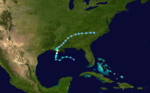
Hurricane Babe was the second named storm
and the first to impact the United States
during the below-average 1977 Atlantic hurricane season
. Forming out of a tropical wave
on September 3, Babe began as a subtropical cyclone
in the eastern Gulf of Mexico
. The storm gradually intensified as it tracked westward. On September 5, the storm turned north and acquired enough tropical characteristics. Later that day, Babe intensified into a hurricane and attained its peak strength with winds of 75 mph (120 km/h) and a barometric pressure of 995 mbar
(hPa
; 29.38 inHg). Several hours later, the hurricane made landfall in Louisiana
and quickly weakened. By September 6, Babe had weakened to a tropical depression and later dissipated early on September 9 over North Carolina
.
Hurricane Babe produced minimal impact throughout its path in the United States. The most significant impact occurred in Louisiana where the storm caused $10 million (1977 USD
; $ USD) in damage, mainly from crop losses. An additional $3 million (1977 USD; $ USD) in losses resulted from tornado
es spawned by Babe. Heavy rainfall in North Carolina, peaking at 8.99 in (228.3 mm) triggered flash flooding but little damage. No fatalities resulted form the hurricane.
 Hurricane Babe originated from a tropical wave
that exited the western coast of Africa on August 23. Tracking westward, the wave eventually entered the Gulf of Mexico
on September 2. Upon entering the gulf, a surface circulation
developed; however, convection
associated with the system was not concentrated around the center. The newly formed system then interacted with an upper tropospheric cyclonic vortex
situated near the Florida coastline. The following day, Convective banding features
around the cyclone led to the National Hurricane Center
(NHC) upgrading the system to Tropical Storm Babe. Although classified a tropical storm, Babe was not fully tropical, it was later classified as a subtropical cyclone
. The forward motion of Babe had slowed significantly from when it was a wave but maintained the westward direction.
By September 4, the maximum winds were found closer to the center of circulation and the cyclone developed a warmer core, a main feature in tropical cyclones. An anticyclone
also developed over Babe and later that day, the storm transitioned into a tropical cyclone. By this time, Babe had turned nearly due north and was near hurricane-status. Around this time, reconnaissance missions into the storm found a closed eyewall
with an eye measuring roughly 23 mi (37 km) in diameter. Another reconnaissance flight that day found sustained winds of 80 mph (130 km/h); however, these winds were located roughly 65 mi (100 km) from the center and considered to be unrepresentative of the storm's actual intensity.
Early on September 5, reconnaissance found a central barometric pressure of 995 mbar (hPa; 29.38 inHg), the lowest recorded in relation to the storm. Around this time, Babe also intensified into a hurricane, attaining maximum winds of 75 mph (120 km/h). Later that day, Hurricane Babe made landfall
near Cocodrie, Louisiana
and quickly weakened to a tropical storm. By landfall, the eye of Babe had contracted to roughly 14 mi (23 km). On September 6, the storm had weakened to a tropical depression and was moving northeast into Mississippi
. The system continued this movement for the following two days. While crossing South Carolina, forecasters thought that the system would emerge into the Atlantic Ocean
and regenerate into a tropical depression. However, the remnants of Babe dissipated shortly before crossing into North Carolina early on September 9.
s were issued for areas along the north-central coast of the Gulf of Mexico. By September 5, hurricane warnings
were posted for areas between Vermilion Bay
to the mouth of the Mississippi River
in Louisiana. These warnings were later discontinued as the system moved over land. Ahead of the storm, up to 30,000 residents in low-lying parts of the state moved inland. However, press reports indicate that upwards of 45,000 residents had evacuated from coastal regions prior to the storm. In Grand Isle
, roughly 200 civil defense workers stayed behind in the town hall after the cities 2,300 residents evacuated. In Cameron Parish
, roughly 8,000 residents evacuated inland. Emergency shelters were set up throughout Louisiana to house evacuees during the storm. As Hurricane Babe began to weaken over Louisiana, forecasters anticipated the formation of tornado
es and issued tornado watch
es for parts of Louisiana, Alabama, Mississippi, Georgia and Florida.
. Widespread rain fell in relation to Babe throughout the Southern United States. In Louisiana, rain was confined to eastern parts of the state, with up to 10 in (254 mm) being measured near the Mississippi border. The remnants of the hurricane continued to produce heavy rain through its dissipation over North Carolina. A storm peak of 10.99 in (279.1 mm) fell in Lafayette, Georgia
. Most of North Carolina received between 3 and 5 in (76.2 and 127 mm) of rain with isolated areas exceeding 7 in (177.8 mm). A state maximum of 8.99 in (228.3 mm) fell in Lake Toxaway, North Carolina
, 7.05 in (179.1 mm) in Caesars Head, South Carolina
and 6.62 in (168.1 mm) in Chattanooga, Tennessee
.
Upon making landfall, Babe produced a storm surge
of 5 ft (1.5 m), leading to minor coastal flooding. Due to the storm's quick deterioration after moving inland, the NHC presumed that hurricane-force winds did not impact land. The highest wind gust was recorded in Grand Isle, Louisiana at 50 mph (85 km/h) and the highest sustained wind was recorded in Boothville, Louisiana at 45 mph (75 km/h). In Jean Lafitte, Louisiana
, overflow from the Fleming Canal produced flooding throughout the area. The most significant damage was to croplands inundated by flood waters. Flash flooding occurred throughout the path of the former hurricane in the eastern United States, particularly in North Carolina.
Hurricane Babe produced 14 tornadoes between September 5 and 7 along its track in several states. Louisiana recorded the most, with six touchdowns, including one F2
that injured one person and caused $2.5 million (1977 USD; $ USD) in damages near Hammond
in Tangipahoa Parish
. A country store sustained severe damage from the tornado, with most of the back of the store destroyed. Six wood-frame homes were also knocked off their cinder block supports. Another F2 touched down in Tuscaloosa County, Alabama
; however, minimal damage was recorded along its 8 mi (12.9 km) track. Another F2 briefly touched down in Harrison County, Mississippi
on September 6. It struck an unoccupied elementary school, wrecking six classrooms and leaving $500,000 (1977 USD; $ USD) in damages. Throughout the storm's path, damages amounted to $10 million (1977 USD; $ USD) with an additional $3 million (1977 USD; $ USD) from tornadoes. There was no loss of life due to Babe.
Due to the relatively minimal damage caused by the storm, the name Babe was not retired; however, after male names were added to the list of Atlantic hurricane names, Babe was removed and has not been used to name a storm since.
Tropical cyclone naming
Tropical cyclones have officially been named since 1945 and are named for a variety of reasons, which include to facilitate communications between forecasters and the public when forecasts, watches, and warnings are issued. Names also reduce confusion about what storm is being described, as more...
and the first to impact the United States
United States
The United States of America is a federal constitutional republic comprising fifty states and a federal district...
during the below-average 1977 Atlantic hurricane season
1977 Atlantic hurricane season
The 1977 Atlantic hurricane season officially began on June 1, 1977, and lasted until November 30, 1977. These dates conventionally delimit the period of each year when most tropical cyclones form in the Atlantic basin....
. Forming out of a tropical wave
Tropical wave
Tropical waves, easterly waves, or tropical easterly waves, also known as African easterly waves in the Atlantic region, are a type of atmospheric trough, an elongated area of relatively low air pressure, oriented north to south, which move from east to west across the tropics causing areas of...
on September 3, Babe began as a subtropical cyclone
Subtropical cyclone
A subtropical cyclone is a weather system that has some characteristics of a tropical and an extratropical cyclone. As early as the 1950s, meteorologists were unclear whether they should be characterized as tropical or extratropical cyclones. They were officially recognized by the National...
in the eastern Gulf of Mexico
Gulf of Mexico
The Gulf of Mexico is a partially landlocked ocean basin largely surrounded by the North American continent and the island of Cuba. It is bounded on the northeast, north and northwest by the Gulf Coast of the United States, on the southwest and south by Mexico, and on the southeast by Cuba. In...
. The storm gradually intensified as it tracked westward. On September 5, the storm turned north and acquired enough tropical characteristics. Later that day, Babe intensified into a hurricane and attained its peak strength with winds of 75 mph (120 km/h) and a barometric pressure of 995 mbar
Bar (unit)
The bar is a unit of pressure equal to 100 kilopascals, and roughly equal to the atmospheric pressure on Earth at sea level. Other units derived from the bar are the megabar , kilobar , decibar , centibar , and millibar...
(hPa
Pascal (unit)
The pascal is the SI derived unit of pressure, internal pressure, stress, Young's modulus and tensile strength, named after the French mathematician, physicist, inventor, writer, and philosopher Blaise Pascal. It is a measure of force per unit area, defined as one newton per square metre...
; 29.38 inHg). Several hours later, the hurricane made landfall in Louisiana
Louisiana
Louisiana is a state located in the southern region of the United States of America. Its capital is Baton Rouge and largest city is New Orleans. Louisiana is the only state in the U.S. with political subdivisions termed parishes, which are local governments equivalent to counties...
and quickly weakened. By September 6, Babe had weakened to a tropical depression and later dissipated early on September 9 over North Carolina
North Carolina
North Carolina is a state located in the southeastern United States. The state borders South Carolina and Georgia to the south, Tennessee to the west and Virginia to the north. North Carolina contains 100 counties. Its capital is Raleigh, and its largest city is Charlotte...
.
Hurricane Babe produced minimal impact throughout its path in the United States. The most significant impact occurred in Louisiana where the storm caused $10 million (1977 USD
United States dollar
The United States dollar , also referred to as the American dollar, is the official currency of the United States of America. It is divided into 100 smaller units called cents or pennies....
; $ USD) in damage, mainly from crop losses. An additional $3 million (1977 USD; $ USD) in losses resulted from tornado
Tornado
A tornado is a violent, dangerous, rotating column of air that is in contact with both the surface of the earth and a cumulonimbus cloud or, in rare cases, the base of a cumulus cloud. They are often referred to as a twister or a cyclone, although the word cyclone is used in meteorology in a wider...
es spawned by Babe. Heavy rainfall in North Carolina, peaking at 8.99 in (228.3 mm) triggered flash flooding but little damage. No fatalities resulted form the hurricane.
Meteorological history
Tropical wave
Tropical waves, easterly waves, or tropical easterly waves, also known as African easterly waves in the Atlantic region, are a type of atmospheric trough, an elongated area of relatively low air pressure, oriented north to south, which move from east to west across the tropics causing areas of...
that exited the western coast of Africa on August 23. Tracking westward, the wave eventually entered the Gulf of Mexico
Gulf of Mexico
The Gulf of Mexico is a partially landlocked ocean basin largely surrounded by the North American continent and the island of Cuba. It is bounded on the northeast, north and northwest by the Gulf Coast of the United States, on the southwest and south by Mexico, and on the southeast by Cuba. In...
on September 2. Upon entering the gulf, a surface circulation
Low pressure area
A low-pressure area, or "low", is a region where the atmospheric pressure at sea level is below that of surrounding locations. Low-pressure systems form under areas of wind divergence which occur in upper levels of the troposphere. The formation process of a low-pressure area is known as...
developed; however, convection
Atmospheric convection
Atmospheric convection is the result of a parcel-environment instability, or temperature difference, layer in the atmosphere. Different lapse rates within dry and moist air lead to instability. Mixing of air during the day which expands the height of the planetary boundary layer leads to...
associated with the system was not concentrated around the center. The newly formed system then interacted with an upper tropospheric cyclonic vortex
Upper tropospheric cyclonic vortex
An upper tropospheric cyclonic vortex is a vortex, or a circulation with a definable center, that usually moves slowly from east-northeast to west-southwest and is prevalent across Northern Hemisphere's warm season. Its circulations generally do not extend below in altitude, as it is an example...
situated near the Florida coastline. The following day, Convective banding features
Rainband
A rainband is a cloud and precipitation structure associated with an area of rainfall which is significantly elongated. Rainbands can be stratiform or convective, and are generated by differences in temperature. When noted on weather radar imagery, this precipitation elongation is referred to as...
around the cyclone led to the National Hurricane Center
National Hurricane Center
The National Hurricane Center , located at Florida International University in Miami, Florida, is the division of the National Weather Service responsible for tracking and predicting weather systems within the tropics between the Prime Meridian and the 140th meridian west poleward to the 30th...
(NHC) upgrading the system to Tropical Storm Babe. Although classified a tropical storm, Babe was not fully tropical, it was later classified as a subtropical cyclone
Subtropical cyclone
A subtropical cyclone is a weather system that has some characteristics of a tropical and an extratropical cyclone. As early as the 1950s, meteorologists were unclear whether they should be characterized as tropical or extratropical cyclones. They were officially recognized by the National...
. The forward motion of Babe had slowed significantly from when it was a wave but maintained the westward direction.
By September 4, the maximum winds were found closer to the center of circulation and the cyclone developed a warmer core, a main feature in tropical cyclones. An anticyclone
Anticyclone
An anticyclone is a weather phenomenon defined by the United States' National Weather Service's glossary as "[a] large-scale circulation of winds around a central region of high atmospheric pressure, clockwise in the Northern Hemisphere, counterclockwise in the Southern Hemisphere"...
also developed over Babe and later that day, the storm transitioned into a tropical cyclone. By this time, Babe had turned nearly due north and was near hurricane-status. Around this time, reconnaissance missions into the storm found a closed eyewall
Eye (cyclone)
The eye is a region of mostly calm weather found at the center of strong tropical cyclones. The eye of a storm is a roughly circular area and typically 30–65 km in diameter. It is surrounded by the eyewall, a ring of towering thunderstorms where the second most severe weather of a cyclone...
with an eye measuring roughly 23 mi (37 km) in diameter. Another reconnaissance flight that day found sustained winds of 80 mph (130 km/h); however, these winds were located roughly 65 mi (100 km) from the center and considered to be unrepresentative of the storm's actual intensity.
Early on September 5, reconnaissance found a central barometric pressure of 995 mbar (hPa; 29.38 inHg), the lowest recorded in relation to the storm. Around this time, Babe also intensified into a hurricane, attaining maximum winds of 75 mph (120 km/h). Later that day, Hurricane Babe made landfall
Landfall (meteorology)
Landfall is the event of a tropical cyclone or a waterspout coming onto land after being over water. When a waterspout makes landfall it is reclassified as a tornado, which can then cause damage inland...
near Cocodrie, Louisiana
Cocodrie, Louisiana
Cocodrie is an unincorporated fishing, shrimping and crabbing village in Terrebonne Parish, Louisiana, United States, ten miles south of Chauvin, due south of the larger town of Houma. It is part of the Houma–Bayou Cane–Thibodaux Metropolitan Statistical Area...
and quickly weakened to a tropical storm. By landfall, the eye of Babe had contracted to roughly 14 mi (23 km). On September 6, the storm had weakened to a tropical depression and was moving northeast into Mississippi
Mississippi
Mississippi is a U.S. state located in the Southern United States. Jackson is the state capital and largest city. The name of the state derives from the Mississippi River, which flows along its western boundary, whose name comes from the Ojibwe word misi-ziibi...
. The system continued this movement for the following two days. While crossing South Carolina, forecasters thought that the system would emerge into the Atlantic Ocean
Atlantic Ocean
The Atlantic Ocean is the second-largest of the world's oceanic divisions. With a total area of about , it covers approximately 20% of the Earth's surface and about 26% of its water surface area...
and regenerate into a tropical depression. However, the remnants of Babe dissipated shortly before crossing into North Carolina early on September 9.
Preparations
Upon the storm's formation on September 3, gale warningGale warning
A gale warning is a warning issued by weather services in maritime locations about the existence of winds of gale force or above or the imminent occurrence of gales at sea...
s were issued for areas along the north-central coast of the Gulf of Mexico. By September 5, hurricane warnings
Tropical cyclone warnings and watches
Warnings and watches are two levels of alert issued by national weather forecasting bodies to coastal areas threatened by the imminent approach of a tropical cyclone of tropical storm or hurricane intensity. They are notices to the local population and civil authorities to make appropriate...
were posted for areas between Vermilion Bay
Vermilion River (Louisiana)
The Vermilion River is a river in southern Louisiana in the United States. It is formed on the common boundary of Lafayette and St. Martin parishes by a confluence of small bayous flowing from St. Landry Parish, and flows generally southward through Lafayette and Vermilion parishes, past the...
to the mouth of the Mississippi River
Mississippi River
The Mississippi River is the largest river system in North America. Flowing entirely in the United States, this river rises in western Minnesota and meanders slowly southwards for to the Mississippi River Delta at the Gulf of Mexico. With its many tributaries, the Mississippi's watershed drains...
in Louisiana. These warnings were later discontinued as the system moved over land. Ahead of the storm, up to 30,000 residents in low-lying parts of the state moved inland. However, press reports indicate that upwards of 45,000 residents had evacuated from coastal regions prior to the storm. In Grand Isle
Grand Isle, Louisiana
Grand Isle is a town in Jefferson Parish, Louisiana, located on a barrier island of the same name in the Gulf of Mexico. The island is at the mouth of Barataria Bay where it meets the gulf. As of the 2000 census, the town population was 1,541; during summers, the population sometimes increases to...
, roughly 200 civil defense workers stayed behind in the town hall after the cities 2,300 residents evacuated. In Cameron Parish
Cameron Parish, Louisiana
Cameron Parish is the parish with the most land area in the U.S. state of Louisiana. The parish seat is Cameron and as of 2010, the population was 6,839...
, roughly 8,000 residents evacuated inland. Emergency shelters were set up throughout Louisiana to house evacuees during the storm. As Hurricane Babe began to weaken over Louisiana, forecasters anticipated the formation of tornado
Tornado
A tornado is a violent, dangerous, rotating column of air that is in contact with both the surface of the earth and a cumulonimbus cloud or, in rare cases, the base of a cumulus cloud. They are often referred to as a twister or a cyclone, although the word cyclone is used in meteorology in a wider...
es and issued tornado watch
Tornado watch
A tornado watch is issued when conditions are right for a tornado to form. Since any thunderstorm capable of producing a tornado is defined as severe, a tornado watch is also automatically a severe thunderstorm watch...
es for parts of Louisiana, Alabama, Mississippi, Georgia and Florida.
Impact
Prior to becoming a subtropical depression, Babe produced scattered rainfall in Florida, with peak amounts near 3 in (76.2 mm) falling around Lake OkeechobeeLake Okeechobee
Lake Okeechobee , locally referred to as The Lake or The Big O, is the largest freshwater lake in the state of Florida. It is the seventh largest freshwater lake in the United States and the second largest freshwater lake contained entirely within the lower 48 states...
. Widespread rain fell in relation to Babe throughout the Southern United States. In Louisiana, rain was confined to eastern parts of the state, with up to 10 in (254 mm) being measured near the Mississippi border. The remnants of the hurricane continued to produce heavy rain through its dissipation over North Carolina. A storm peak of 10.99 in (279.1 mm) fell in Lafayette, Georgia
LaFayette, Georgia
LaFayette is a city in Walker County, Georgia, United States. As of the 2000 Census, the city population was 6,702. The city is the county seat of Walker County.LaFayette is part of the Chattanooga, TN–GA Metropolitan Statistical Area.-Geography:...
. Most of North Carolina received between 3 and 5 in (76.2 and 127 mm) of rain with isolated areas exceeding 7 in (177.8 mm). A state maximum of 8.99 in (228.3 mm) fell in Lake Toxaway, North Carolina
Lake Toxaway, North Carolina
Lake Toxaway is an unincorporated community in western Transylvania County, North Carolina on U.S. Route 64, and North Carolina Highway 281. It lies at an elevation of 2979 feet ....
, 7.05 in (179.1 mm) in Caesars Head, South Carolina
Caesars Head, South Carolina
Caesars Head is a mountain within Caesars Head State Park in northern Greenville County, South Carolina. The summit has an elevation of . The radio tower for TV station WYFF is nearby....
and 6.62 in (168.1 mm) in Chattanooga, Tennessee
Chattanooga, Tennessee
Chattanooga is the fourth-largest city in the US state of Tennessee , with a population of 169,887. It is the seat of Hamilton County...
.
Upon making landfall, Babe produced a storm surge
Storm surge
A storm surge is an offshore rise of water associated with a low pressure weather system, typically tropical cyclones and strong extratropical cyclones. Storm surges are caused primarily by high winds pushing on the ocean's surface. The wind causes the water to pile up higher than the ordinary sea...
of 5 ft (1.5 m), leading to minor coastal flooding. Due to the storm's quick deterioration after moving inland, the NHC presumed that hurricane-force winds did not impact land. The highest wind gust was recorded in Grand Isle, Louisiana at 50 mph (85 km/h) and the highest sustained wind was recorded in Boothville, Louisiana at 45 mph (75 km/h). In Jean Lafitte, Louisiana
Jean Lafitte, Louisiana
Jean Lafitte is a town on Bayou Barataria in Jefferson Parish, Louisiana, United States. It is named after the privateer Jean Lafitte. The population was 2,137 at the 2000 census...
, overflow from the Fleming Canal produced flooding throughout the area. The most significant damage was to croplands inundated by flood waters. Flash flooding occurred throughout the path of the former hurricane in the eastern United States, particularly in North Carolina.
Hurricane Babe produced 14 tornadoes between September 5 and 7 along its track in several states. Louisiana recorded the most, with six touchdowns, including one F2
Fujita scale
The Fujita scale , or Fujita-Pearson scale, is a scale for rating tornado intensity, based primarily on the damage tornadoes inflict on human-built structures and vegetation...
that injured one person and caused $2.5 million (1977 USD; $ USD) in damages near Hammond
Hammond, Louisiana
Hammond is the largest city in Tangipahoa Parish, Louisiana, United States. The population was 20,049 at the 2009 census. It is home to Southeastern Louisiana University...
in Tangipahoa Parish
Tangipahoa Parish, Louisiana
Tangipahoa Parish is a parish located in the U.S. state of Louisiana, one of the Florida Parishes. The parish seat is Amite City, but the major city is Hammond. As of 2006, the population was 113,137...
. A country store sustained severe damage from the tornado, with most of the back of the store destroyed. Six wood-frame homes were also knocked off their cinder block supports. Another F2 touched down in Tuscaloosa County, Alabama
Tuscaloosa County, Alabama
Tuscaloosa County is a county of the U.S. state of Alabama.It is named in honor of the pre-Choctaw chief Tuskaloosa. In 2010, the population was 194,656...
; however, minimal damage was recorded along its 8 mi (12.9 km) track. Another F2 briefly touched down in Harrison County, Mississippi
Harrison County, Mississippi
-National protected areas:* De Soto National Forest * Gulf Islands National Seashore - Demographics :As of the census of 2000, there were 189,601 people, 71,538 households, and 48,574 families residing in the county. The population density was 326 people per square mile . There were 79,636 housing...
on September 6. It struck an unoccupied elementary school, wrecking six classrooms and leaving $500,000 (1977 USD; $ USD) in damages. Throughout the storm's path, damages amounted to $10 million (1977 USD; $ USD) with an additional $3 million (1977 USD; $ USD) from tornadoes. There was no loss of life due to Babe.
Due to the relatively minimal damage caused by the storm, the name Babe was not retired; however, after male names were added to the list of Atlantic hurricane names, Babe was removed and has not been used to name a storm since.