
.gif)
Tropical Depression One (1992)
Encyclopedia
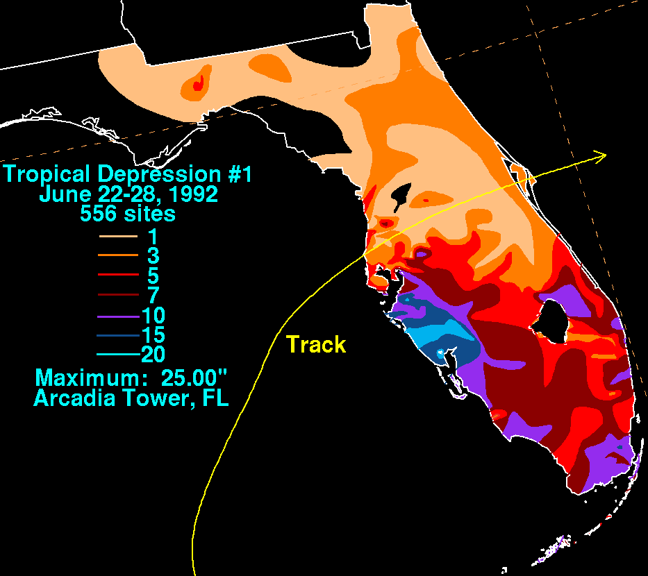
Tropical Depression One in June 1992 produced 100-year flood
s in portions of southwestern Florida
. The first tropical depression and second tropical cyclone
of the 1992 Atlantic hurricane season
, the depression developed on June 25 from a tropical wave
. Located in an environment of strong wind shear
, much of the convection
in the system was located well to the southeast of the poorly defined center of circulation. The depression moved northeastward and struck near Tampa, Florida
on June 26 shortly before dissipating over land.
The depression, in combination with an upper-level trough
to its west, produced heavy rainfall to the east of its path, peaking at 33.43 inches (849 mm) in Cuba
and 25 inches (635 mm) in Florida. In Cuba, the rainfall destroyed hundreds of homes and caused two fatalities. In Florida, particularly in Sarasota
and Manatee
counties, the rainfall caused severe flooding. 4,000 houses were affected, forcing thousands to evacuate. The flooding killed two in the state and was indirectly responsible for a traffic causality. Damage in Florida totaled over $2.6 million (1992 USD, $4 million 2009 USD).
moved off the coast of Africa
on June 12. It tracked westward across the tropical Atlantic Ocean
with minimal convection
, and subsequent to moving through the southern Windward Islands
it crossed northern Central America
. Convection increased on June 20 as the wave entered the southwestern Caribbean Sea
. Under the influence of southeasterly flow from developing Hurricane Celia in the eastern Pacific Ocean
and the south-southwesterly flow from a mid- to upper-level trough
over the Gulf of Mexico
, the area of disturbed weather tracked generally north-northwestward through the Caribbean Sea while spreading across Cuba and southern Florida. On June 24, a mid-level circulation developed near the Yucatán Channel
, and shortly thereafer satellite image loops indicated deep convection with some cyclonic rotation near the western tip of Cuba. A reconnaissance aircraft
flight was dispatched late on June 24 into the system to determine if it developed into a tropical cyclone
, though the flight did not observe evidence of a closed low-level circulation. Subsequent to the flight, satellite imagery indicated a low-level circulation was forming, and on June 25 ship and buoy data confirmed the system developed into Tropical Depression One while located about 235 miles (375 km) west-southwest of Key West, Florida
. Operationally, the National Hurricane Center
incorrectly classified the system as Tropical Depression Two due to an earlier subtropical storm.
Upon becoming a tropical cyclone, the depression was poorly organized, with much of the convection located well to the southeast of the broad center due to strong upper-level wind shear
. The shearing environment was caused by a trough in the Gulf of Mexico and from the outflow from Pacific Hurricane Celia. This was reflected in forecasts, with the National Hurricane Center predicting no significant change in intensity or structure. The depression moved northward before turning to the northeast, and on June 26 the poorly-organized system made landfall
just north of Tampa, Florida
. The low-level circulation dissipated while crossing the Florida peninsula
, with the remnants continuing northeastward before being absorbed by a large extratropical cyclone
over the western Atlantic.
 The tropical depression, in combination with the upper-level trough to its west, produced moderate precipitation across Cuba, peaking at 33.43 inches (849 mm). This is the fifth highest known rainfall total from a tropical cyclone in the country. The rainfall primarily affected the provinces of Pinar del Rio
, Matanzas
, and Havana. Two Cuban citizens were killed by the rainfall, with an Arab student reported missing and presumed drowned. The deluge damaged or destroyed hundreds of houses in Pinar del Rio and Havana provinces.
In Florida, the depression produced moderate winds near the coast, peaking at 51 mph (82 km/h) in Naples
. As in Cuba, the system dropped torrential rainfall, peaking at 25 inches (635 mm) at Arcadia Tower. Large portions of the state reported totals in excess of 10 inches (255 mm) from the depression, with much of Sarasota County
receiving over 20 inches (510 mm) of rain. The rainfall was classified as a 100-year flood
in Sarasota and Manatee
counties, where flooding reached 6 feet (1.8 m) deep in some locations. Officials in Manatee County declared a state of emergency in response to the flooding. There, about 3,000 people were forced to evacuate their homes due to the flooding, some of whom left by boat. The flooding damaged about 50 houses in and around Oneco
. Due to the evacuations, no injuries were reported. The reservoir in Manatee County rose to over 39 feet (11.9 m), 4 feet (1.2 m) above normal, which resulted in officials opening floodgates to prevent flooding.
 In Sarasota County, the flooding closed several roads and led to many overflown creeks and rivers, including the Horse Creek which crested at 5.8 feet (1.8 m) above flood level. Damage to roads and bridges totaled about $1 million (1992 USD, $1.5 million 2008 USD). Due to the flat landscape of the region, the flooding persisted for several days. The depression spawned a tornado in a mobile home
park in Nokomis
, destroying the roofs of five homes and causing leaks in twelve others. Throughout the area, the passage of the depression left about 45,000 customers without power, primarily due to gusty winds. The outages were fairly short-lived due to power companies calling in extra workers to restore the power. Moderate winds toppled a construction crane at the northern end of the Sunshine Skyway Bridge
, closing the bridge for 35 minutes before the crane was removed. In Pinellas County
, a man hydroplaned while driving along a flooded roadway; he crashed into a concrete pole and was killed. Severe crop damage to orange trees was reported in association with the flooding. Damage from the depression totaled over $2.6 million (1992 USD, $4 million 2008 USD), with about 4,000 houses affected by the flooding and an additional 70 destroyed. Two people were killed in Florida.
On August 14, about six weeks after the flooding, President
George H. W. Bush
declared a major disaster area for Charlotte
, DeSoto
, Manatee, and Sarasota counties. The declaration allowed for the use of federal funding to assist in the aftermath of the system.
100-year flood
A one-hundred-year flood is calculated to be the level of flood water expected to be equaled or exceeded every 100 years on average. The 100-year flood is more accurately referred to as the 1% annual exceedance probability flood, since it is a flood that has a 1% chance of being equaled or exceeded...
s in portions of southwestern Florida
Florida
Florida is a state in the southeastern United States, located on the nation's Atlantic and Gulf coasts. It is bordered to the west by the Gulf of Mexico, to the north by Alabama and Georgia and to the east by the Atlantic Ocean. With a population of 18,801,310 as measured by the 2010 census, it...
. The first tropical depression and second tropical cyclone
Tropical cyclone
A tropical cyclone is a storm system characterized by a large low-pressure center and numerous thunderstorms that produce strong winds and heavy rain. Tropical cyclones strengthen when water evaporated from the ocean is released as the saturated air rises, resulting in condensation of water vapor...
of the 1992 Atlantic hurricane season
1992 Atlantic hurricane season
The 1992 Atlantic hurricane season had one of the latest dates on record for the first named storm. The season officially began on June 1, 1992, and lasted until November 30, 1992. It was the least active hurricane season in nine years due to a strong El Niño...
, the depression developed on June 25 from a tropical wave
Tropical wave
Tropical waves, easterly waves, or tropical easterly waves, also known as African easterly waves in the Atlantic region, are a type of atmospheric trough, an elongated area of relatively low air pressure, oriented north to south, which move from east to west across the tropics causing areas of...
. Located in an environment of strong wind shear
Wind shear
Wind shear, sometimes referred to as windshear or wind gradient, is a difference in wind speed and direction over a relatively short distance in the atmosphere...
, much of the convection
Convection
Convection is the movement of molecules within fluids and rheids. It cannot take place in solids, since neither bulk current flows nor significant diffusion can take place in solids....
in the system was located well to the southeast of the poorly defined center of circulation. The depression moved northeastward and struck near Tampa, Florida
Tampa, Florida
Tampa is a city in the U.S. state of Florida. It serves as the county seat for Hillsborough County. Tampa is located on the west coast of Florida. The population of Tampa in 2010 was 335,709....
on June 26 shortly before dissipating over land.
The depression, in combination with an upper-level trough
Trough (meteorology)
A trough is an elongated region of relatively low atmospheric pressure, often associated with fronts.Unlike fronts, there is not a universal symbol for a trough on a weather chart. The weather charts in some countries or regions mark troughs by a line. In the United States, a trough may be marked...
to its west, produced heavy rainfall to the east of its path, peaking at 33.43 inches (849 mm) in Cuba
Cuba
The Republic of Cuba is an island nation in the Caribbean. The nation of Cuba consists of the main island of Cuba, the Isla de la Juventud, and several archipelagos. Havana is the largest city in Cuba and the country's capital. Santiago de Cuba is the second largest city...
and 25 inches (635 mm) in Florida. In Cuba, the rainfall destroyed hundreds of homes and caused two fatalities. In Florida, particularly in Sarasota
Sarasota County, Florida
Sarasota County is a county located in the U.S. state of Florida. The U.S. Census Bureau 2008 estimate for the county was 372,057. Its county seat is Sarasota, Florida....
and Manatee
Manatee County, Florida
Manatee County is a county in the state of Florida. According to the 2010 census by the U.S. Census Bureau there are 322,833 people living in Manatee Country.Manatee County is part of the North Port-Bradenton-Sarasota Metropolitan Statistical Area...
counties, the rainfall caused severe flooding. 4,000 houses were affected, forcing thousands to evacuate. The flooding killed two in the state and was indirectly responsible for a traffic causality. Damage in Florida totaled over $2.6 million (1992 USD, $4 million 2009 USD).
Meteorological history
A weak tropical waveTropical wave
Tropical waves, easterly waves, or tropical easterly waves, also known as African easterly waves in the Atlantic region, are a type of atmospheric trough, an elongated area of relatively low air pressure, oriented north to south, which move from east to west across the tropics causing areas of...
moved off the coast of Africa
Africa
Africa is the world's second largest and second most populous continent, after Asia. At about 30.2 million km² including adjacent islands, it covers 6% of the Earth's total surface area and 20.4% of the total land area...
on June 12. It tracked westward across the tropical Atlantic Ocean
Atlantic Ocean
The Atlantic Ocean is the second-largest of the world's oceanic divisions. With a total area of about , it covers approximately 20% of the Earth's surface and about 26% of its water surface area...
with minimal convection
Convection
Convection is the movement of molecules within fluids and rheids. It cannot take place in solids, since neither bulk current flows nor significant diffusion can take place in solids....
, and subsequent to moving through the southern Windward Islands
Windward Islands
The Windward Islands are the southern islands of the Lesser Antilles, within the West Indies.-Name and geography:The Windward Islands are called such because they were more windward to sailing ships arriving in the New World than the Leeward Islands, given that the prevailing trade winds in the...
it crossed northern Central America
Central America
Central America is the central geographic region of the Americas. It is the southernmost, isthmian portion of the North American continent, which connects with South America on the southeast. When considered part of the unified continental model, it is considered a subcontinent...
. Convection increased on June 20 as the wave entered the southwestern Caribbean Sea
Caribbean Sea
The Caribbean Sea is a sea of the Atlantic Ocean located in the tropics of the Western hemisphere. It is bounded by Mexico and Central America to the west and southwest, to the north by the Greater Antilles, and to the east by the Lesser Antilles....
. Under the influence of southeasterly flow from developing Hurricane Celia in the eastern Pacific Ocean
Pacific Ocean
The Pacific Ocean is the largest of the Earth's oceanic divisions. It extends from the Arctic in the north to the Southern Ocean in the south, bounded by Asia and Australia in the west, and the Americas in the east.At 165.2 million square kilometres in area, this largest division of the World...
and the south-southwesterly flow from a mid- to upper-level trough
Trough (meteorology)
A trough is an elongated region of relatively low atmospheric pressure, often associated with fronts.Unlike fronts, there is not a universal symbol for a trough on a weather chart. The weather charts in some countries or regions mark troughs by a line. In the United States, a trough may be marked...
over the Gulf of Mexico
Gulf of Mexico
The Gulf of Mexico is a partially landlocked ocean basin largely surrounded by the North American continent and the island of Cuba. It is bounded on the northeast, north and northwest by the Gulf Coast of the United States, on the southwest and south by Mexico, and on the southeast by Cuba. In...
, the area of disturbed weather tracked generally north-northwestward through the Caribbean Sea while spreading across Cuba and southern Florida. On June 24, a mid-level circulation developed near the Yucatán Channel
Yucatán Channel
The Yucatán Channel is a strait between Mexico and Cuba. It connects the Yucatán Basin of the Caribbean Sea with the Gulf of Mexico. The strait is across between Cape Catoche in Mexico and Cape San Antonio, Cuba and reaches a maximum depth of .-References:...
, and shortly thereafer satellite image loops indicated deep convection with some cyclonic rotation near the western tip of Cuba. A reconnaissance aircraft
Hurricane Hunters
The Hurricane Hunters are aircraft that fly into tropical cyclones in the North Atlantic Ocean and Northeastern Pacific Ocean for the specific purpose of directly measuring weather data in and around those storms. In the United States, the Air Force, Navy, and NOAA units have all participated in...
flight was dispatched late on June 24 into the system to determine if it developed into a tropical cyclone
Tropical cyclone
A tropical cyclone is a storm system characterized by a large low-pressure center and numerous thunderstorms that produce strong winds and heavy rain. Tropical cyclones strengthen when water evaporated from the ocean is released as the saturated air rises, resulting in condensation of water vapor...
, though the flight did not observe evidence of a closed low-level circulation. Subsequent to the flight, satellite imagery indicated a low-level circulation was forming, and on June 25 ship and buoy data confirmed the system developed into Tropical Depression One while located about 235 miles (375 km) west-southwest of Key West, Florida
Key West, Florida
Key West is a city in Monroe County, Florida, United States. The city encompasses the island of Key West, the part of Stock Island north of U.S. 1 , Sigsbee Park , Fleming Key , and Sunset Key...
. Operationally, the National Hurricane Center
National Hurricane Center
The National Hurricane Center , located at Florida International University in Miami, Florida, is the division of the National Weather Service responsible for tracking and predicting weather systems within the tropics between the Prime Meridian and the 140th meridian west poleward to the 30th...
incorrectly classified the system as Tropical Depression Two due to an earlier subtropical storm.
Upon becoming a tropical cyclone, the depression was poorly organized, with much of the convection located well to the southeast of the broad center due to strong upper-level wind shear
Wind shear
Wind shear, sometimes referred to as windshear or wind gradient, is a difference in wind speed and direction over a relatively short distance in the atmosphere...
. The shearing environment was caused by a trough in the Gulf of Mexico and from the outflow from Pacific Hurricane Celia. This was reflected in forecasts, with the National Hurricane Center predicting no significant change in intensity or structure. The depression moved northward before turning to the northeast, and on June 26 the poorly-organized system made landfall
Landfall (meteorology)
Landfall is the event of a tropical cyclone or a waterspout coming onto land after being over water. When a waterspout makes landfall it is reclassified as a tornado, which can then cause damage inland...
just north of Tampa, Florida
Tampa, Florida
Tampa is a city in the U.S. state of Florida. It serves as the county seat for Hillsborough County. Tampa is located on the west coast of Florida. The population of Tampa in 2010 was 335,709....
. The low-level circulation dissipated while crossing the Florida peninsula
Florida
Florida is a state in the southeastern United States, located on the nation's Atlantic and Gulf coasts. It is bordered to the west by the Gulf of Mexico, to the north by Alabama and Georgia and to the east by the Atlantic Ocean. With a population of 18,801,310 as measured by the 2010 census, it...
, with the remnants continuing northeastward before being absorbed by a large extratropical cyclone
Extratropical cyclone
Extratropical cyclones, sometimes called mid-latitude cyclones or wave cyclones, are a group of cyclones defined as synoptic scale low pressure weather systems that occur in the middle latitudes of the Earth having neither tropical nor polar characteristics, and are connected with fronts and...
over the western Atlantic.
Impact
Pinar del Río Province
Pinar del Río is one of the provinces of Cuba. It is at the western end of the island of Cuba.-Geography:The Pinar del Río province is Cuba's westernmost province and contains one of Cuba's three main mountain ranges, the Cordillera de Guaniguanico, divided into the easterly Sierra del Rosario and...
, Matanzas
Matanzas Province
Matanzas is one of the provinces of Cuba. Major towns in the province include Cárdenas, Colón, Jovellanos and the capital of the same name, Matanzas...
, and Havana. Two Cuban citizens were killed by the rainfall, with an Arab student reported missing and presumed drowned. The deluge damaged or destroyed hundreds of houses in Pinar del Rio and Havana provinces.
In Florida, the depression produced moderate winds near the coast, peaking at 51 mph (82 km/h) in Naples
Naples, Florida
Naples is a city in Collier County, Florida, United States. As of July 1, 2007, the U.S. Census Bureau estimated the city's population at 21,653. Naples is a principal city of the Naples–Marco Island Metropolitan Statistical Area, which had an estimated total population of 315,839 on July 1, 2007...
. As in Cuba, the system dropped torrential rainfall, peaking at 25 inches (635 mm) at Arcadia Tower. Large portions of the state reported totals in excess of 10 inches (255 mm) from the depression, with much of Sarasota County
Sarasota County, Florida
Sarasota County is a county located in the U.S. state of Florida. The U.S. Census Bureau 2008 estimate for the county was 372,057. Its county seat is Sarasota, Florida....
receiving over 20 inches (510 mm) of rain. The rainfall was classified as a 100-year flood
100-year flood
A one-hundred-year flood is calculated to be the level of flood water expected to be equaled or exceeded every 100 years on average. The 100-year flood is more accurately referred to as the 1% annual exceedance probability flood, since it is a flood that has a 1% chance of being equaled or exceeded...
in Sarasota and Manatee
Manatee County, Florida
Manatee County is a county in the state of Florida. According to the 2010 census by the U.S. Census Bureau there are 322,833 people living in Manatee Country.Manatee County is part of the North Port-Bradenton-Sarasota Metropolitan Statistical Area...
counties, where flooding reached 6 feet (1.8 m) deep in some locations. Officials in Manatee County declared a state of emergency in response to the flooding. There, about 3,000 people were forced to evacuate their homes due to the flooding, some of whom left by boat. The flooding damaged about 50 houses in and around Oneco
Oneco, Florida
Oneco, pronounced oh-nee-kuh, is an unincorporated community in Manatee County, Florida, United States. It is a suburb of Bradenton, located just southeast of the city. The community is part of the Bradenton–Sarasota–Venice Metropolitan Statistical Area. In the 1920 Census it was...
. Due to the evacuations, no injuries were reported. The reservoir in Manatee County rose to over 39 feet (11.9 m), 4 feet (1.2 m) above normal, which resulted in officials opening floodgates to prevent flooding.
Mobile home
Mobile homes or static caravans are prefabricated homes built in factories, rather than on site, and then taken to the place where they will be occupied...
park in Nokomis
Nokomis, Florida
Nokomis is a census-designated place in Sarasota County, Florida, United States. The population was 3,334 at the 2000 census. It is part of the Bradenton–Sarasota–Venice Metropolitan Statistical Area....
, destroying the roofs of five homes and causing leaks in twelve others. Throughout the area, the passage of the depression left about 45,000 customers without power, primarily due to gusty winds. The outages were fairly short-lived due to power companies calling in extra workers to restore the power. Moderate winds toppled a construction crane at the northern end of the Sunshine Skyway Bridge
Sunshine Skyway Bridge
The Bob Graham Sunshine Skyway Bridge is a bridge spanning Tampa Bay, Florida, with a cable-stayed main span, and a total length of 21,877 feet . It is part of I-275 and US 19 , connecting St. Petersburg in Pinellas County and Terra Ceia in Manatee County, Florida, passing through Hillsborough...
, closing the bridge for 35 minutes before the crane was removed. In Pinellas County
Pinellas County, Florida
Pinellas County is a county located in the state of Florida. Its county seat is Clearwater, Florida, and its largest city is St. Petersburg. This county is contained entirely within the telephone area code 727, except for some sections of Oldsmar, which have the area code 813...
, a man hydroplaned while driving along a flooded roadway; he crashed into a concrete pole and was killed. Severe crop damage to orange trees was reported in association with the flooding. Damage from the depression totaled over $2.6 million (1992 USD, $4 million 2008 USD), with about 4,000 houses affected by the flooding and an additional 70 destroyed. Two people were killed in Florida.
On August 14, about six weeks after the flooding, President
President of the United States
The President of the United States of America is the head of state and head of government of the United States. The president leads the executive branch of the federal government and is the commander-in-chief of the United States Armed Forces....
George H. W. Bush
George H. W. Bush
George Herbert Walker Bush is an American politician who served as the 41st President of the United States . He had previously served as the 43rd Vice President of the United States , a congressman, an ambassador, and Director of Central Intelligence.Bush was born in Milton, Massachusetts, to...
declared a major disaster area for Charlotte
Charlotte County, Florida
Charlotte County is a county located in the U.S. state of Florida. As of 2000, the population was 141,627. In 2005, the population of the MSA was 154,030.The U.S. Census Bureau 2007 estimate for the county was 152,814...
, DeSoto
DeSoto County, Florida
DeSoto County is a county located in the U.S. state of Florida. As of 2000, the population was 32,209. The U.S. Census Bureau 2005 estimate for the county is 35,406 . Its county seat is Arcadia, Florida. The county comprises the Arcadia, Florida Micropolitan Statistical Area.- History :DeSoto...
, Manatee, and Sarasota counties. The declaration allowed for the use of federal funding to assist in the aftermath of the system.
See also
- List of wettest tropical cyclones in Cuba since 1963
- List of Florida hurricanes