
.gif)
Subtropical Storm One (1982)
Encyclopedia
The 1982 Florida subtropical storm, officially known as Subtropical Storm One, was the only subtropical cyclone
of the inactive 1982 Atlantic hurricane season
. The storm originated from two different systems around the Gulf of Mexico
and Caribbean Sea
on June 16. The systems merged into trough while a circulation began to form off the coast of Florida
on June 18. The depression made landfall in Florida
and strengthened into a storm over land. The storm entered the Atlantic Ocean
and headed to the northeast, becoming extratropical on June 20 near Newfoundland
. The storm was the only system of 1982 to affect the eastern half of the United States
, and it caused three fatalities and caused $10 million in damage (1982 USD
, $21 million 2007 USD).
. This occurrence is unusual, but not unique, as Subtropical Storm One in the 1974 season
formed in similar pattern. A reconnaissance
flight on June 17 reported that there appeared to be multiple transient circulations at the surface, but no well-defined center. The first disturbance can be traced back to June 15 in the northwest Caribbean Sea
. The disturbance moved north, along with a low-pressure area that formed over the Yucatán Peninsula
. A trough
merged with the low-pressure area creating an even stronger trough over the eastern Gulf of Mexico
. Conditions in the Gulf of Mexico
were favorable for tropical storm formation. Some severe weather had been occurring over the Florida Peninsula
as early as June 16, as the fringes of disturbance moved across the Florida Straits and over the Peninsula.
A circulation began to form on June 18 in the eastern Gulf of Mexico
, prompting gale warnings. It was declared Subtropical Depression One the same day. The depression made landfall on the morning of June 18 just north of Spring Hill, Florida
and gained subtropical storm status over land. The storm was classified as Subtropical Storm One by the National Hurricane Center
, as the rule was not to name subtropical storms. The subtropical storm moved to the northeast and crossed the Outer Banks
of North Carolina
on June 19. Even though the minimum central pressures remained low, the circulation expanded and became distorted. The subtropical storm peaked at 70 mph winds (110 km/h) on June 18, but did not reach its minimum pressure until June 20, when it dropped to 984 mbar
(29.07 inHg
). The subtropical storm was declared an extratropical storm near the Canadian Maritimes the same day.
. The next day, more warnings were issued, including tornado, small craft, and special marine warnings. There were also various types of special weather statements issued for heavy rains. Five gale warnings were issued on June 18 and June 19 for the cities on the western coast of Florida. All warnings were discontinued by 12 p.m. EDT (1600 UTC) June 19. The same day, a gale warning was issued from Cape Henlopen, Delaware
to Watch Hill, Rhode Island.
The subtropical storm postponed the bi-annual Newport, Rhode Island
to Bermuda
sailboat race for two consecutive days due to the forecast one of the storm. Subsequent reports from sailboats said that with the track of the storm, if not for the delay, there would have been a marine disaster.
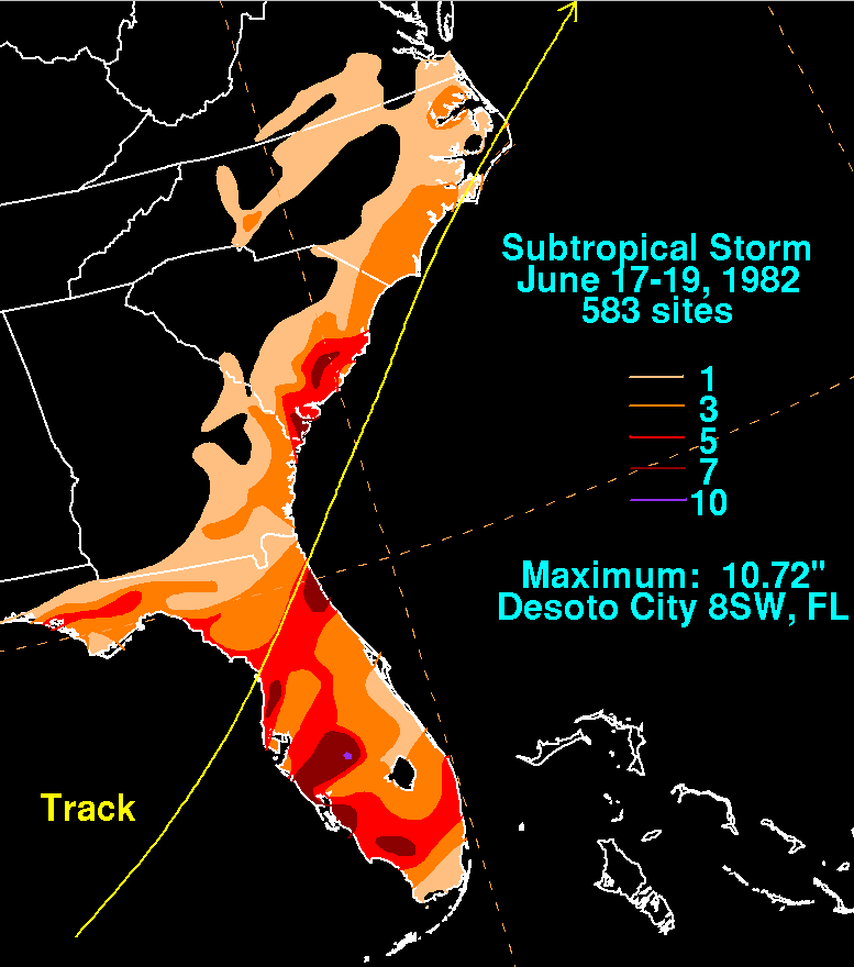 Most of the storm's effects were felt in Florida where it made landfall on the morning of June 18, causing gales, heavy rains, flooding, beach erosion and tornadoes. The highest winds were recorded at 41 mph (66 km/h) and up to 48 mph (77 km/h) during a thunderstorm at Macdill Air Force Base
in Tampa
on June 18. Rainfall peaked at 10.72 inches (272.28 mm) in Desoto City
, while much of the rest of the state reported between 1–5 inches (25–125 inches) of precipitation. High tides and waves caused flooding and beach erosion from Naples
to the Tampa Bay area. Some waterfront buildings suffered damage from undermining including widespread damage of marinas and some boats. Several bulkheads and rock revetment
s experienced minor damage in Naples and Marco Island
. Several man‑made dune structures seaward of the Coastal Construction Control Line in Collier County
received minor damage at Vanderbilt Beach
and Marco Island. Three people were killed in Florida in association with the subtropical storm with a further thirteen people injured. A Brevard County
woman died when a canoe overturned and an Orange County
child was killed when he was swept into a drainage ditch. 130 families were evacuated a few days after the storm from the Arcadia River area because the Peace River
crested above flood stage.
The subtropical storm spawned twelve tornadoes across Florida, including at least 2 tornadoes which reached a magnitude of F2 on the Fujita Scale
. The first tornado formed in Hendry County
on June 18 at 0115 UTC reaching F2 strength. The third fatality was a man from Hendry County
who was killed in his mobile home, which was destroyed by a tornado. A total of twenty-five homes in Florida were destroyed. Total damage in Florida totaled out to $10 million (1982 USD, $21 million 2007 USD).
The storm's effects north of Florida were minor. Rainfall reached up to nine inches (228 mm) in extreme eastern South Carolina
and four inches (101 mm) in eastern North Carolina
. Winds reached 50 mph (60 km/h) with gusts up to 66 mph (101 km/h) at the Oak Island Coast Guard Station near Cape Fear, North Carolina and 54 mph (87 km/h) with gusts of 77 mph (123 km/h) at the offshore tower at Frying Pan Shoals about forty miles southeast of Cape Fear on June 18 with 70 mph winds (110 km/h) the next day. A 68 foot fishing trawler sunk off the coast of Cape Fear in North Carolina
from the high waves; no one was killed as the sailors were rescued by the United States Coast Guard
on June 19. Flooding was reported with tides of two to three feet in the Carolinas. Rainfall from the subtropical storm reached both states, reaching maximum peaks of up to five inches (127 mm) on the Georgia
coast and seven inches on the Georgia/South Carolina
border. Rainfall totaled to about one inch (25 mm) on the Virginian coast. A ship encountered winds of a minimum tropical storm with gusts as high as a maximum tropical storm. The ship also encountered a tidal surge of 15 to 20 feet.
Subtropical cyclone
A subtropical cyclone is a weather system that has some characteristics of a tropical and an extratropical cyclone. As early as the 1950s, meteorologists were unclear whether they should be characterized as tropical or extratropical cyclones. They were officially recognized by the National...
of the inactive 1982 Atlantic hurricane season
1982 Atlantic hurricane season
The 1982 Atlantic hurricane season officially began on June 1, 1982 and lasted until November 30, 1982, and was a below average season. These dates conventionally delimit the period of each year when most tropical cyclones form in the Atlantic basin...
. The storm originated from two different systems around the Gulf of Mexico
Gulf of Mexico
The Gulf of Mexico is a partially landlocked ocean basin largely surrounded by the North American continent and the island of Cuba. It is bounded on the northeast, north and northwest by the Gulf Coast of the United States, on the southwest and south by Mexico, and on the southeast by Cuba. In...
and Caribbean Sea
Caribbean Sea
The Caribbean Sea is a sea of the Atlantic Ocean located in the tropics of the Western hemisphere. It is bounded by Mexico and Central America to the west and southwest, to the north by the Greater Antilles, and to the east by the Lesser Antilles....
on June 16. The systems merged into trough while a circulation began to form off the coast of Florida
Florida
Florida is a state in the southeastern United States, located on the nation's Atlantic and Gulf coasts. It is bordered to the west by the Gulf of Mexico, to the north by Alabama and Georgia and to the east by the Atlantic Ocean. With a population of 18,801,310 as measured by the 2010 census, it...
on June 18. The depression made landfall in Florida
Florida
Florida is a state in the southeastern United States, located on the nation's Atlantic and Gulf coasts. It is bordered to the west by the Gulf of Mexico, to the north by Alabama and Georgia and to the east by the Atlantic Ocean. With a population of 18,801,310 as measured by the 2010 census, it...
and strengthened into a storm over land. The storm entered the Atlantic Ocean
Atlantic Ocean
The Atlantic Ocean is the second-largest of the world's oceanic divisions. With a total area of about , it covers approximately 20% of the Earth's surface and about 26% of its water surface area...
and headed to the northeast, becoming extratropical on June 20 near Newfoundland
Newfoundland and Labrador
Newfoundland and Labrador is the easternmost province of Canada. Situated in the country's Atlantic region, it incorporates the island of Newfoundland and mainland Labrador with a combined area of . As of April 2011, the province's estimated population is 508,400...
. The storm was the only system of 1982 to affect the eastern half of the United States
United States
The United States of America is a federal constitutional republic comprising fifty states and a federal district...
, and it caused three fatalities and caused $10 million in damage (1982 USD
United States dollar
The United States dollar , also referred to as the American dollar, is the official currency of the United States of America. It is divided into 100 smaller units called cents or pennies....
, $21 million 2007 USD).
Meteorological history
The subtropical storm had an unusual origin by forming from an interaction of two different systems near the Yucatán PeninsulaYucatán Peninsula
The Yucatán Peninsula, in southeastern Mexico, separates the Caribbean Sea from the Gulf of Mexico, with the northern coastline on the Yucatán Channel...
. This occurrence is unusual, but not unique, as Subtropical Storm One in the 1974 season
1974 Atlantic hurricane season
The 1974 Atlantic hurricane season officially began on June 1, 1974, and lasted until November 30, 1974. These dates conventionally delimit the period of each year when most tropical cyclones form in the Atlantic basin...
formed in similar pattern. A reconnaissance
Reconnaissance aircraft
A reconnaissance aircraft is a manned military aircraft designed, or adapted, to carry out aerial reconnaissance.-History:The majority of World War I aircraft were reconnaissance designs...
flight on June 17 reported that there appeared to be multiple transient circulations at the surface, but no well-defined center. The first disturbance can be traced back to June 15 in the northwest Caribbean Sea
Caribbean Sea
The Caribbean Sea is a sea of the Atlantic Ocean located in the tropics of the Western hemisphere. It is bounded by Mexico and Central America to the west and southwest, to the north by the Greater Antilles, and to the east by the Lesser Antilles....
. The disturbance moved north, along with a low-pressure area that formed over the Yucatán Peninsula
Yucatán Peninsula
The Yucatán Peninsula, in southeastern Mexico, separates the Caribbean Sea from the Gulf of Mexico, with the northern coastline on the Yucatán Channel...
. A trough
Trough (meteorology)
A trough is an elongated region of relatively low atmospheric pressure, often associated with fronts.Unlike fronts, there is not a universal symbol for a trough on a weather chart. The weather charts in some countries or regions mark troughs by a line. In the United States, a trough may be marked...
merged with the low-pressure area creating an even stronger trough over the eastern Gulf of Mexico
Gulf of Mexico
The Gulf of Mexico is a partially landlocked ocean basin largely surrounded by the North American continent and the island of Cuba. It is bounded on the northeast, north and northwest by the Gulf Coast of the United States, on the southwest and south by Mexico, and on the southeast by Cuba. In...
. Conditions in the Gulf of Mexico
Gulf of Mexico
The Gulf of Mexico is a partially landlocked ocean basin largely surrounded by the North American continent and the island of Cuba. It is bounded on the northeast, north and northwest by the Gulf Coast of the United States, on the southwest and south by Mexico, and on the southeast by Cuba. In...
were favorable for tropical storm formation. Some severe weather had been occurring over the Florida Peninsula
Florida
Florida is a state in the southeastern United States, located on the nation's Atlantic and Gulf coasts. It is bordered to the west by the Gulf of Mexico, to the north by Alabama and Georgia and to the east by the Atlantic Ocean. With a population of 18,801,310 as measured by the 2010 census, it...
as early as June 16, as the fringes of disturbance moved across the Florida Straits and over the Peninsula.
A circulation began to form on June 18 in the eastern Gulf of Mexico
Gulf of Mexico
The Gulf of Mexico is a partially landlocked ocean basin largely surrounded by the North American continent and the island of Cuba. It is bounded on the northeast, north and northwest by the Gulf Coast of the United States, on the southwest and south by Mexico, and on the southeast by Cuba. In...
, prompting gale warnings. It was declared Subtropical Depression One the same day. The depression made landfall on the morning of June 18 just north of Spring Hill, Florida
Spring Hill, Florida
Spring Hill is a census-designated place in Hernando County, Florida, United States. The estimated population was 92,144 in 2007 by the United States Census. Spring Hill belongs to Florida's Nature Coast and is in the Tampa-St...
and gained subtropical storm status over land. The storm was classified as Subtropical Storm One by the National Hurricane Center
National Hurricane Center
The National Hurricane Center , located at Florida International University in Miami, Florida, is the division of the National Weather Service responsible for tracking and predicting weather systems within the tropics between the Prime Meridian and the 140th meridian west poleward to the 30th...
, as the rule was not to name subtropical storms. The subtropical storm moved to the northeast and crossed the Outer Banks
Outer Banks
The Outer Banks is a 200-mile long string of narrow barrier islands off the coast of North Carolina, beginning in the southeastern corner of Virginia Beach on the east coast of the United States....
of North Carolina
North Carolina
North Carolina is a state located in the southeastern United States. The state borders South Carolina and Georgia to the south, Tennessee to the west and Virginia to the north. North Carolina contains 100 counties. Its capital is Raleigh, and its largest city is Charlotte...
on June 19. Even though the minimum central pressures remained low, the circulation expanded and became distorted. The subtropical storm peaked at 70 mph winds (110 km/h) on June 18, but did not reach its minimum pressure until June 20, when it dropped to 984 mbar
Bar (unit)
The bar is a unit of pressure equal to 100 kilopascals, and roughly equal to the atmospheric pressure on Earth at sea level. Other units derived from the bar are the megabar , kilobar , decibar , centibar , and millibar...
(29.07 inHg
Inch of mercury
Inches of mercury, ' is a unit of measurement for pressure. It is still widely used for barometric pressure in weather reports, refrigeration and aviation in the United States, but is seldom used elsewhere....
). The subtropical storm was declared an extratropical storm near the Canadian Maritimes the same day.
Preparations
Several warnings were issued in association with the subtropical storm. On June 16, severe thunderstorm watches and warnings were issued for FloridaFlorida
Florida is a state in the southeastern United States, located on the nation's Atlantic and Gulf coasts. It is bordered to the west by the Gulf of Mexico, to the north by Alabama and Georgia and to the east by the Atlantic Ocean. With a population of 18,801,310 as measured by the 2010 census, it...
. The next day, more warnings were issued, including tornado, small craft, and special marine warnings. There were also various types of special weather statements issued for heavy rains. Five gale warnings were issued on June 18 and June 19 for the cities on the western coast of Florida. All warnings were discontinued by 12 p.m. EDT (1600 UTC) June 19. The same day, a gale warning was issued from Cape Henlopen, Delaware
Cape Henlopen
Cape Henlopen is the southern cape of the Delaware Bay along the Atlantic coast of the United States. It lies in the state of Delaware, near the town of Lewes, Delaware...
to Watch Hill, Rhode Island.
The subtropical storm postponed the bi-annual Newport, Rhode Island
Newport, Rhode Island
Newport is a city on Aquidneck Island in Newport County, Rhode Island, United States, about south of Providence. Known as a New England summer resort and for the famous Newport Mansions, it is the home of Salve Regina University and Naval Station Newport which houses the United States Naval War...
to Bermuda
Bermuda
Bermuda is a British overseas territory in the North Atlantic Ocean. Located off the east coast of the United States, its nearest landmass is Cape Hatteras, North Carolina, about to the west-northwest. It is about south of Halifax, Nova Scotia, Canada, and northeast of Miami, Florida...
sailboat race for two consecutive days due to the forecast one of the storm. Subsequent reports from sailboats said that with the track of the storm, if not for the delay, there would have been a marine disaster.
Impact
In its main inflow band over Cuba, rainfall amounts up to 28.66 inches (728 mm) were recorded.MacDill Air Force Base
MacDill Air Force Base is an active United States Air Force base located approximately south-southwest of downtown Tampa, Florida...
in Tampa
Tampa, Florida
Tampa is a city in the U.S. state of Florida. It serves as the county seat for Hillsborough County. Tampa is located on the west coast of Florida. The population of Tampa in 2010 was 335,709....
on June 18. Rainfall peaked at 10.72 inches (272.28 mm) in Desoto City
DeSoto County, Florida
DeSoto County is a county located in the U.S. state of Florida. As of 2000, the population was 32,209. The U.S. Census Bureau 2005 estimate for the county is 35,406 . Its county seat is Arcadia, Florida. The county comprises the Arcadia, Florida Micropolitan Statistical Area.- History :DeSoto...
, while much of the rest of the state reported between 1–5 inches (25–125 inches) of precipitation. High tides and waves caused flooding and beach erosion from Naples
Naples, Florida
Naples is a city in Collier County, Florida, United States. As of July 1, 2007, the U.S. Census Bureau estimated the city's population at 21,653. Naples is a principal city of the Naples–Marco Island Metropolitan Statistical Area, which had an estimated total population of 315,839 on July 1, 2007...
to the Tampa Bay area. Some waterfront buildings suffered damage from undermining including widespread damage of marinas and some boats. Several bulkheads and rock revetment
Revetment
Revetments, or revêtements , have a variety of meanings in architecture, engineering and art history. In stream restoration, river engineering or coastal management, they are sloping structures placed on banks or cliffs in such a way as to absorb the energy of incoming water...
s experienced minor damage in Naples and Marco Island
Marco Island, Florida
Marco Island is a city in Collier County, Florida, United States, located on an island by the same name in the Gulf of Mexico off the coast of Southwest Florida. It is a principal city of the Naples–Marco Island Metropolitan Statistical Area...
. Several man‑made dune structures seaward of the Coastal Construction Control Line in Collier County
Collier County, Florida
Collier County is a county located in the U.S. state of Florida. As of 2000, the population was 251,377. The U.S. Census Bureau 2007 estimate for the county is 315,839...
received minor damage at Vanderbilt Beach
Vanderbilt beach
Vanderbilt Beach is a several mile long stretch of beach in Naples, Florida. It is a popular tourist destination, with many hotels including the Ritz-Carlton Naples....
and Marco Island. Three people were killed in Florida in association with the subtropical storm with a further thirteen people injured. A Brevard County
Brevard County, Florida
Brevard County is a county located in the U.S. state of Florida, along the coast of the Atlantic Ocean. As of 2007 U.S. Census Bureau estimates, the population is 536,521, making it the 10th most populous county in the state. Influenced by the presence of the John F. Kennedy Space Center, Brevard...
woman died when a canoe overturned and an Orange County
Orange County, Florida
Orange County is a county located in the U.S. state of Florida and is part of the Orlando-Kissimmee-Sanford Metropolitan Statistical Area . As of 2010 U.S. Census, the county had a population of 1,145,956....
child was killed when he was swept into a drainage ditch. 130 families were evacuated a few days after the storm from the Arcadia River area because the Peace River
Peace River (Florida)
The Peace River is a river in the southwestern part of the Florida peninsula, in the U.S.A.. It originates at the juncture of Saddle Creek and Peace Creek northeast of Bartow in Polk County and flows south through Hardee County to Arcadia in DeSoto County and then southwest into the Charlotte...
crested above flood stage.
The subtropical storm spawned twelve tornadoes across Florida, including at least 2 tornadoes which reached a magnitude of F2 on the Fujita Scale
Fujita scale
The Fujita scale , or Fujita-Pearson scale, is a scale for rating tornado intensity, based primarily on the damage tornadoes inflict on human-built structures and vegetation...
. The first tornado formed in Hendry County
Hendry County, Florida
Hendry County is a county located in the U.S. state of Florida. As of 2000, the population was 36,210. The U.S. Census Bureau 2007 estimate for the county is 39,611 . Its county seat is La Belle. The county comprises the Clewiston, Florida, Micropolitan Statistical Area.-History:Hendry County...
on June 18 at 0115 UTC reaching F2 strength. The third fatality was a man from Hendry County
Hendry County, Florida
Hendry County is a county located in the U.S. state of Florida. As of 2000, the population was 36,210. The U.S. Census Bureau 2007 estimate for the county is 39,611 . Its county seat is La Belle. The county comprises the Clewiston, Florida, Micropolitan Statistical Area.-History:Hendry County...
who was killed in his mobile home, which was destroyed by a tornado. A total of twenty-five homes in Florida were destroyed. Total damage in Florida totaled out to $10 million (1982 USD, $21 million 2007 USD).
The storm's effects north of Florida were minor. Rainfall reached up to nine inches (228 mm) in extreme eastern South Carolina
South Carolina
South Carolina is a state in the Deep South of the United States that borders Georgia to the south, North Carolina to the north, and the Atlantic Ocean to the east. Originally part of the Province of Carolina, the Province of South Carolina was one of the 13 colonies that declared independence...
and four inches (101 mm) in eastern North Carolina
North Carolina
North Carolina is a state located in the southeastern United States. The state borders South Carolina and Georgia to the south, Tennessee to the west and Virginia to the north. North Carolina contains 100 counties. Its capital is Raleigh, and its largest city is Charlotte...
. Winds reached 50 mph (60 km/h) with gusts up to 66 mph (101 km/h) at the Oak Island Coast Guard Station near Cape Fear, North Carolina and 54 mph (87 km/h) with gusts of 77 mph (123 km/h) at the offshore tower at Frying Pan Shoals about forty miles southeast of Cape Fear on June 18 with 70 mph winds (110 km/h) the next day. A 68 foot fishing trawler sunk off the coast of Cape Fear in North Carolina
North Carolina
North Carolina is a state located in the southeastern United States. The state borders South Carolina and Georgia to the south, Tennessee to the west and Virginia to the north. North Carolina contains 100 counties. Its capital is Raleigh, and its largest city is Charlotte...
from the high waves; no one was killed as the sailors were rescued by the United States Coast Guard
United States Coast Guard
The United States Coast Guard is a branch of the United States Armed Forces and one of the seven U.S. uniformed services. The Coast Guard is a maritime, military, multi-mission service unique among the military branches for having a maritime law enforcement mission and a federal regulatory agency...
on June 19. Flooding was reported with tides of two to three feet in the Carolinas. Rainfall from the subtropical storm reached both states, reaching maximum peaks of up to five inches (127 mm) on the Georgia
Georgia (U.S. state)
Georgia is a state located in the southeastern United States. It was established in 1732, the last of the original Thirteen Colonies. The state is named after King George II of Great Britain. Georgia was the fourth state to ratify the United States Constitution, on January 2, 1788...
coast and seven inches on the Georgia/South Carolina
South Carolina
South Carolina is a state in the Deep South of the United States that borders Georgia to the south, North Carolina to the north, and the Atlantic Ocean to the east. Originally part of the Province of Carolina, the Province of South Carolina was one of the 13 colonies that declared independence...
border. Rainfall totaled to about one inch (25 mm) on the Virginian coast. A ship encountered winds of a minimum tropical storm with gusts as high as a maximum tropical storm. The ship also encountered a tidal surge of 15 to 20 feet.
See also
- Subtropical cycloneSubtropical cycloneA subtropical cyclone is a weather system that has some characteristics of a tropical and an extratropical cyclone. As early as the 1950s, meteorologists were unclear whether they should be characterized as tropical or extratropical cyclones. They were officially recognized by the National...
- 1982 Atlantic hurricane season1982 Atlantic hurricane seasonThe 1982 Atlantic hurricane season officially began on June 1, 1982 and lasted until November 30, 1982, and was a below average season. These dates conventionally delimit the period of each year when most tropical cyclones form in the Atlantic basin...
- List of Atlantic hurricanes
- Timeline of the 1982 Atlantic hurricane seasonTimeline of the 1982 Atlantic hurricane seasonThe 1982 Atlantic hurricane season was an inactive Atlantic hurricane season, during which five tropical cyclones formed. The season officially began on June 1, 1982 and ended on November 30, dates which conventionally limit the period of each year when tropical cyclones tend to form in the...
- List of North Carolina hurricanes (1980–present)