
.gif)
Hurricane Danny (1997)
Encyclopedia
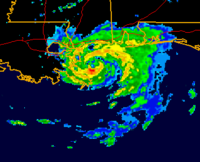
Hurricane Danny was the only hurricane
to make landfall
in the United States
during the 1997 Atlantic hurricane season
, and the second hurricane and fourth tropical storm of the season. The system became the earliest-formed fifth tropical or subtropical
storm of the Atlantic season in history when it attained tropical storm strength
on July 17, and held that record until the 2005 Atlantic hurricane season
when Tropical Storm Emily
broke that record by several days. Like the previous four tropical or subtropical
cyclones of the season, Danny had a non-tropical origin, after a trough
spawned convection that entered the warm waters
of the Gulf of Mexico
. Danny was guided northeast through the Gulf of Mexico by two high pressure areas
, a rare occurrence in the middle of July. After making landfall on the Gulf Coast, Danny tracked across the southeastern United States
and ultimately affected parts of New England
with rain and wind
.
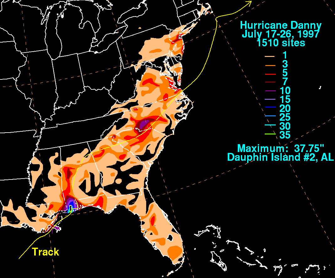
Danny is notable for its extreme rainfall, the tornadoes generated by it, and the destruction
it produced on its path, causing a total of nine fatalities and $ (1997 USD
, $ USD) in damage. The storm dropped a record amount of rainfall for Alabama, as at least 36.71 inches (932 mm) fell on Dauphin Island. Flooding, power outages, and erosion occurred in many areas of the Gulf Coast, and rescues had to be executed from flooded roadways. Tornadoes generated by Danny on the East Coast
caused a great amount of damage. Of the nine fatalities caused by Danny, one happened off the coast of Alabama
, four occurred in Georgia
, two occurred in South Carolina
, and two occurred in North Carolina
.
trough
over the southeastern United States spawned an area of convection
over the lower Mississippi River Valley on July 13, and drifted southward towards the warm waters
of the Gulf of Mexico
. As it moved into the Gulf of Mexico, a weak and isolated surface low pressure area
formed off the coast of Louisiana
. The circulation
in the system steadily expanded, and initially the surface winds and convection were intermittent. On July 16, deep convection increased and organized near the center, and oil rigs and surface buoys
reported surface winds of 30 mph (50 km/h). Based on the observations, it is estimated the system developed into Tropical Depression Four on July 16 while about 150 miles (240 km) south of the southwestern Louisiana coastline.
 The depression slowly organized for the next day, as it drifted to the northeast. On July 17, the rate of organization and development of deep convection increased considerably, and the depression strengthened into Tropical Storm Danny later that day. From the night of July 17 through July 18, Danny quickly developed deep convection
and banding features in the favorable environment of the Gulf of Mexico, and reached hurricane status later on July 18. Located between two high pressure systems, Danny continued its unusual July track to the northeast, and crossed over southeastern Louisiana near the Mississippi River Delta
. A small storm, Danny continued to strengthen after reaching the coastal waters off Mississippi
on the night of July 18, and attained a peak of 80 mph (130 km/h) early on July 19. The hurricane force winds, however, were confined to the eyewall. After stalling near the mouth of Mobile Bay
on July 19, Hurricane Danny turned to the east, and made its final landfall near Mullet Point, Alabama
later that day.
The storm rapidly weakened as it continued northward, and degenerated into a tropical depression by July 20. The weak depression moved through Alabama
, Georgia
, South Carolina
, and North Carolina
, maintaining a well-defined cloud
signature. Due to a front
behind the system, Danny unusually strengthened to a tropical storm over North Carolina on July 24. This rare phenomenon occurred due to interaction with a developing trough and its associated baroclinic zone.
Danny entered the Atlantic Ocean
, north of the North Carolina
-Virginia
border, near Virginia Beach. It quickly reached a secondary peak of 60 miles per hour (96.6 km/h), and continued rapidly northeastward towards the waters of the Atlantic. A strong mid to upper-level cyclone turned Danny northward, threatening Massachusetts
. It stalled while just 30 miles (48.3 km) southeast of Nantucket
on July 26, turned to the east out to sea, and became extratropical
later that day. On July 27, the former hurricane merged with a frontal zone
.
 The National Hurricane Center
issued a hurricane watch
on July 17, as Danny strengthened to a tropical storm, for the coasts of Louisiana, Mississippi, and Alabama. When Danny strengthened to a hurricane on July 18, a few hours before its landfall in far southeastern Louisiana and over a day before landfall in Alabama
, the hurricane watch was upgraded to a hurricane warning. Grand Isle
mayor Arthur Ballenger ordered the evacuation
of the town's 1,500 residents, a decision made due to the large number of tourists on the island and to prevent anyone from being unable to leave the island. With a 5 foot (1.5 m) storm surge possibility, it had the potential to flood the only highway out of the island. Officials distributed sandbags to residents in St. Bernard Parish to seal off easily flooded roads, with officials recommending that residents leave the area.
Prior to the arrival of the hurricane, the governors of Mississippi and Alabama declared disaster emergencies, expecting a 9 feet (2.7 m) storm surge and up to 20 inches (508 mm) of rain at that time. Six shelters
were opened in Mobile County, though few attended them. Officials also considered opening shelters near local casinos and beaches in Biloxi, Mississippi
.
Southeastern Massachusetts
also had a tropical storm warning issued, a few hours before sustained tropical storm force winds affected the area and less than 12 hours before its closest approach to the coastline.
 As a small storm, Tropical Storm Danny only caused a damage toll of $ (1997 USD
, $ USD). A total of 4 direct and 5 indirect deaths resulted from the effects of Danny.
. A small radius
near the center of the storm had much of the extreme rainfall, and limited the flooding, which could have been disastrous if it were widespread. Grand Isle and portions of the lower Plaquemines Parish were the worst hit in Louisiana. Additionally, Grand Isle reported a wind gust of 100 mph (160 km/h) and a storm surge of 5.2 feet (1.6 m). At New Orleans International Airport, sustained winds of 28 mph (45 km/h) and gusts of 33 mph (53 km/h) were reported on July 19. A gauge reported a water level of 4.85 feet (1.5 m) in Venice
. Storm tides were 2 to 3 feet (0.6 to 0.9 meters) above normal on average.
At least 10,000 people lost electricity in Louisiana. Furthermore, 130 boats were damaged or sunk at a large marina
in Buras, Louisiana, due to the storm surge of over 4 feet (1.2 m), in a matter of minutes. Both Grand Isle
and Grand Terre Island
received erosion on their shores. Around 160 household
s and 80 business
es reported damage on Grand Isle. Jefferson Parish and Plaquemines Parish, both located on Grand Isle, had $ (1997 USD, $ USD) and $ (1997 USD, $ USD) total in damage respectively. Jefferson Parish had significant flooding, in addition to 163 houses and 84 businesses becoming flooded as a result of Danny. Meanwhile in Plaquemines Parish, ten houses and 35 trailers had damage, with 8 businesses at least partially flooded and 40 commercial fishing boats also damaged. Lafourche Parish had no significant damage to report. Empire
and Venice
had the greatest damage in Plaquemines Parish. Within the hurricane protection levees in the parish, trees, power lines, house roofs, and mobile homes had damage inflicted, as well as the localized flooding that occurred in Plaquemines, after about 10 inches of rain. Some highways were flooded, due to storm tides, in lower Terrebonne Parish
, and a few roads in St. Bernard and Orleans parishes, which were outside the hurricane protection levees. Negligible damage occurred elsewhere in the extreme southeastern portion of Louisiana, due to Danny being a small tropical cyclone and a minimal hurricane.
Eastern Jackson County
had the greatest impact throughout Mississippi. Pascagoula
reported a wind gust of 35 mph (55 km/h) on July 19. Pascagoula airport reported 7.87 inches (200 mm) of rain from July 17 through July 19. Some streets and a few homes were flooded in far southeastern Jackson County, in areas of poor drainage systems. The coast of Mississippi had no significant damage according to emergency management officials.
Extreme amounts of rainfall were produced over Alabama
. Dauphin Island had the highest amount of rainfall, 37.75 inches (959 mm) reported by the HPC
. Dauphin Island Sea Lab recorded 36.71 inches (932 mm) of rain, but not all the rain may have recorded in the rain gauge at this location, so it is possible the rainfall may have been underestimated. Doppler weather radar estimates show that around 43 inches (1,090 mm) of rain fell off the coast of Dauphin Island. A storm surge of over 6.5 feet (1.98 m) occurred off Highway 182, midway between Gulf Shores
and Fort Morgan
, in addition to the rainfall. Unusually, when the storm stalled off the coast of Alabama, prevailing northerly winds forced the water out of Mobile Bay
, causing tides to be two feet (0.61 m) below normal. Observers noted that, with the exception of river channels
, it would be possible to walk across the bay. In addition, three tornadoes occurred in Alabama, one being in Orange Beach
, another in Opelika
, while the other one occurred in Alabama Port
. There were some other tornadoes that also caused minimal damage.
Despite its effects in the northern Gulf of Mexico
, only one person was directly killed from the storm there; a man drowned
off the coast when he fell off his sailboat near Fort Morgan, Alabama
. One indirect casualty also occurred in the area, when a man had a heart attack while trying to secure a boat off the Alabama coast during the storm. Numerous roads became flooded and impassable for several days, south and along I-10 in Mobile
, south and central Choctaw
, and Baldwin
counties. Along the Fowl
and Fish
rivers, in Mobile and Baldwin counties respectively, significant damage to homes occurred due to flooding. Most roads on Dauphin Island were flooded in over a foot of water. A few homes were close to falling into Mobile Bay
, and one home had to be moved backwards towards land to prevent its destruction. At the peak of the storm in Alabama
, at least 44,000 people were without power in Mobile
and Baldwin
counties. In rural Choctaw County
, north of Mobile, several families were rescued from flooded roads and trapped cars. The majority of houses and businesses on Dauphin Island and buildings from the western shore of Mobile Bay
, and from Fort Morgan
east to Orange Beach
, had roof
damage. $ (1997 USD, $ USD) in total property damage occurred in Alabama, in addition to pecan
and pine tree damage costing $ (1997 USD, $ USD).
.gif) In the state of Florida
In the state of Florida
, some damage to the cotton crop occurred in Escambia County
. Otherwise,very little damage resulted from the storm in northwestern Florida. The Panama City
area had some minor fresh water
flooding. By the time Danny reached Georgia
and the Carolinas
, its impact potential had weakened, though it still managed to produce 8–12 in (20.3–30.5 ) of rain as it drifted through the western portions of the states. A severe
thunderstorm
cell in South Carolina produced five tornadoes that touched down, one of which killed a woman in her destroyed duplex while passing through Lexington County. An F2 tornado with a width of 200 yards (182.9 m) and a length of 4 miles (6 km), was on the ground for 3 miles (5 km) to the northeast of Gaston, South Carolina
, causing $942,000 (1997 USD, $ USD) in damage, killing one, injuring six, and destroying 13 residences, with damage to many others. Several tornadoes and waterspouts were spawned over Virginia
; most of them occurred in Norfolk
, Portsmouth
, and Hampton
. An F1 tornado with a width of 50 yard and a length of 1 miles (1.6 km), touched down 1 miles (1.6 km) in Portsmouth
, causing $400,000 (1997 USD, $ USD) in damage. It destroyed a car wash and damaged 7 other structures, all but 1 of which were businesses, and also flipped over a semi-trailer truck
. Rainfall in Fayetteville
measured 2.85 inches (7.2 cm), while the remainder of the Mid-Atlantic states received approximately 3 inches (76 mm) of rain.
The heavy rains caused two people to drown in Charlotte
. A girl drowned after being swept into a creek, and a woman drowned while in her car. Four indirect deaths occurred from traffic accidents during the storm's onslaught in Georgia. A severe drought had been in place in the Mid-Atlantic States
during the month of July. Copious rainfall amounts helped bring a minor relief to the drought. Sustained tropical-storm force winds affected Martha's Vineyard
, Nantucket Island, and parts of Cape Cod
, in addition to the coastal waters from the entrance of Buzzards Bay
to the south and east of Cape Cod
. Only minor damage occurred, despite these strong winds, which were experienced primarily in southeastern Massachusetts
. The minor damage included localized flooding, power outages, downed tree limbs, and lost boats. A suspension of ferry
service to Nantucket Island occurred for most of July 25, with a shorter suspension happening on the service to Martha's Vineyard. No significant coastal flooding affected the region, although a storm shelter was opened on Nantucket Island to host a Boy Scout
group camping there. Danny was the fifth tropical cyclone to affect Southern New England in the 20th century during the month of July.
until at least August 12, 1997. Endangered or threatened sea turtles lived in these waters and were threatened by the debris. Specialized turtle exclusion devices, known as TED's, or specialized nets
that allowed the turtles to escape them, were required before Danny for shrimp trawlers. The Director of the Marine
Resources Division of the Alabama Department of Conservation and Natural Resources
said that the "inordinate amount of debris
is causing extraordinary difficulty with the performance of (TED's) in these areas." Therefore, the United States Environmental Protection Agency
allowed an alternative to the TED's, of shorter tow times of a maximum of 55 minutes from April 1 through October 31, and a maximum of 75 minutes from November 1 through March 31. The EPA intended to minimize any sea turtle casualties as a result of allowing trawlers to remove the TED's.
The storm dropped 36.71 inches (932 mm) of rain on Dauphin Island, setting the new record for the most tropical or subtropical cyclone related rainfall in the state of Alabama, and is among the largest in the United States
. The storm also became the earliest 5th tropical or subtropical storm of a season when it reached tropical storm strength on July 17. This record was broken in the 2005 Atlantic hurricane season
when Hurricane Emily
first attained tropical storm status on July 12, just five days earlier.
Tropical cyclone
A tropical cyclone is a storm system characterized by a large low-pressure center and numerous thunderstorms that produce strong winds and heavy rain. Tropical cyclones strengthen when water evaporated from the ocean is released as the saturated air rises, resulting in condensation of water vapor...
to make landfall
Landfall (meteorology)
Landfall is the event of a tropical cyclone or a waterspout coming onto land after being over water. When a waterspout makes landfall it is reclassified as a tornado, which can then cause damage inland...
in the United States
United States
The United States of America is a federal constitutional republic comprising fifty states and a federal district...
during the 1997 Atlantic hurricane season
1997 Atlantic hurricane season
The 1997 Atlantic hurricane season is the most recent Atlantic hurricane season to feature no tropical cyclones in August. The season officially began on June 1, 1997, and lasted until November 30, 1997...
, and the second hurricane and fourth tropical storm of the season. The system became the earliest-formed fifth tropical or subtropical
Subtropical cyclone
A subtropical cyclone is a weather system that has some characteristics of a tropical and an extratropical cyclone. As early as the 1950s, meteorologists were unclear whether they should be characterized as tropical or extratropical cyclones. They were officially recognized by the National...
storm of the Atlantic season in history when it attained tropical storm strength
Saffir-Simpson Hurricane Scale
The Saffir–Simpson Hurricane Scale , or the Saffir–Simpson Hurricane Wind Scale , classifies hurricanes — Western Hemisphere tropical cyclones that exceed the intensities of tropical depressions and tropical storms — into five categories distinguished by the intensities of their sustained winds...
on July 17, and held that record until the 2005 Atlantic hurricane season
2005 Atlantic hurricane season
The 2005 Atlantic hurricane season was the most active Atlantic hurricane season in recorded history, repeatedly shattering numerous records. The impact of the season was widespread and ruinous with an estimated 3,913 deaths and record damage of about $159.2 billion...
when Tropical Storm Emily
Hurricane Emily (2005)
Hurricane Emily was a powerful, early season tropical cyclone that caused significant damage across the Caribbean Sea to Mexico. A Cape Verde-type hurricane, the storm formed on July 10, 2005, in the central Atlantic Ocean before passing through the Windward Islands on July 14...
broke that record by several days. Like the previous four tropical or subtropical
Subtropical cyclone
A subtropical cyclone is a weather system that has some characteristics of a tropical and an extratropical cyclone. As early as the 1950s, meteorologists were unclear whether they should be characterized as tropical or extratropical cyclones. They were officially recognized by the National...
cyclones of the season, Danny had a non-tropical origin, after a trough
Trough (meteorology)
A trough is an elongated region of relatively low atmospheric pressure, often associated with fronts.Unlike fronts, there is not a universal symbol for a trough on a weather chart. The weather charts in some countries or regions mark troughs by a line. In the United States, a trough may be marked...
spawned convection that entered the warm waters
Sea surface temperature
Sea surface temperature is the water temperature close to the oceans surface. The exact meaning of surface varies according to the measurement method used, but it is between and below the sea surface. Air masses in the Earth's atmosphere are highly modified by sea surface temperatures within a...
of the Gulf of Mexico
Gulf of Mexico
The Gulf of Mexico is a partially landlocked ocean basin largely surrounded by the North American continent and the island of Cuba. It is bounded on the northeast, north and northwest by the Gulf Coast of the United States, on the southwest and south by Mexico, and on the southeast by Cuba. In...
. Danny was guided northeast through the Gulf of Mexico by two high pressure areas
High pressure area
A high-pressure area is a region where the atmospheric pressure at the surface of the planet is greater than its surrounding environment. Winds within high-pressure areas flow outward due to the higher density air near their center and friction with land...
, a rare occurrence in the middle of July. After making landfall on the Gulf Coast, Danny tracked across the southeastern United States
Southeastern United States
The Southeastern United States, colloquially referred to as the Southeast, is the eastern portion of the Southern United States. It is one of the most populous regions in the United States of America....
and ultimately affected parts of New England
New England
New England is a region in the northeastern corner of the United States consisting of the six states of Maine, New Hampshire, Vermont, Massachusetts, Rhode Island, and Connecticut...
with rain and wind
Wind
Wind is the flow of gases on a large scale. On Earth, wind consists of the bulk movement of air. In outer space, solar wind is the movement of gases or charged particles from the sun through space, while planetary wind is the outgassing of light chemical elements from a planet's atmosphere into space...
.
Danny is notable for its extreme rainfall, the tornadoes generated by it, and the destruction
Natural disaster
A natural disaster is the effect of a natural hazard . It leads to financial, environmental or human losses...
it produced on its path, causing a total of nine fatalities and $ (1997 USD
United States dollar
The United States dollar , also referred to as the American dollar, is the official currency of the United States of America. It is divided into 100 smaller units called cents or pennies....
, $ USD) in damage. The storm dropped a record amount of rainfall for Alabama, as at least 36.71 inches (932 mm) fell on Dauphin Island. Flooding, power outages, and erosion occurred in many areas of the Gulf Coast, and rescues had to be executed from flooded roadways. Tornadoes generated by Danny on the East Coast
East Coast of the United States
The East Coast of the United States, also known as the Eastern Seaboard, refers to the easternmost coastal states in the United States, which touch the Atlantic Ocean and stretch up to Canada. The term includes the U.S...
caused a great amount of damage. Of the nine fatalities caused by Danny, one happened off the coast of Alabama
Alabama
Alabama is a state located in the southeastern region of the United States. It is bordered by Tennessee to the north, Georgia to the east, Florida and the Gulf of Mexico to the south, and Mississippi to the west. Alabama ranks 30th in total land area and ranks second in the size of its inland...
, four occurred in Georgia
Georgia (U.S. state)
Georgia is a state located in the southeastern United States. It was established in 1732, the last of the original Thirteen Colonies. The state is named after King George II of Great Britain. Georgia was the fourth state to ratify the United States Constitution, on January 2, 1788...
, two occurred in South Carolina
South Carolina
South Carolina is a state in the Deep South of the United States that borders Georgia to the south, North Carolina to the north, and the Atlantic Ocean to the east. Originally part of the Province of Carolina, the Province of South Carolina was one of the 13 colonies that declared independence...
, and two occurred in North Carolina
North Carolina
North Carolina is a state located in the southeastern United States. The state borders South Carolina and Georgia to the south, Tennessee to the west and Virginia to the north. North Carolina contains 100 counties. Its capital is Raleigh, and its largest city is Charlotte...
.
Meteorological history
A broad mid-troposphericTroposphere
The troposphere is the lowest portion of Earth's atmosphere. It contains approximately 80% of the atmosphere's mass and 99% of its water vapor and aerosols....
trough
Trough (meteorology)
A trough is an elongated region of relatively low atmospheric pressure, often associated with fronts.Unlike fronts, there is not a universal symbol for a trough on a weather chart. The weather charts in some countries or regions mark troughs by a line. In the United States, a trough may be marked...
over the southeastern United States spawned an area of convection
Convection
Convection is the movement of molecules within fluids and rheids. It cannot take place in solids, since neither bulk current flows nor significant diffusion can take place in solids....
over the lower Mississippi River Valley on July 13, and drifted southward towards the warm waters
Sea surface temperature
Sea surface temperature is the water temperature close to the oceans surface. The exact meaning of surface varies according to the measurement method used, but it is between and below the sea surface. Air masses in the Earth's atmosphere are highly modified by sea surface temperatures within a...
of the Gulf of Mexico
Gulf of Mexico
The Gulf of Mexico is a partially landlocked ocean basin largely surrounded by the North American continent and the island of Cuba. It is bounded on the northeast, north and northwest by the Gulf Coast of the United States, on the southwest and south by Mexico, and on the southeast by Cuba. In...
. As it moved into the Gulf of Mexico, a weak and isolated surface low pressure area
Low pressure area
A low-pressure area, or "low", is a region where the atmospheric pressure at sea level is below that of surrounding locations. Low-pressure systems form under areas of wind divergence which occur in upper levels of the troposphere. The formation process of a low-pressure area is known as...
formed off the coast of Louisiana
Louisiana
Louisiana is a state located in the southern region of the United States of America. Its capital is Baton Rouge and largest city is New Orleans. Louisiana is the only state in the U.S. with political subdivisions termed parishes, which are local governments equivalent to counties...
. The circulation
Atmospheric circulation
Atmospheric circulation is the large-scale movement of air, and the means by which thermal energy is distributed on the surface of the Earth....
in the system steadily expanded, and initially the surface winds and convection were intermittent. On July 16, deep convection increased and organized near the center, and oil rigs and surface buoys
Buoy
A buoy is a floating device that can have many different purposes. It can be anchored or allowed to drift. The word, of Old French or Middle Dutch origin, is now most commonly in UK English, although some orthoepists have traditionally prescribed the pronunciation...
reported surface winds of 30 mph (50 km/h). Based on the observations, it is estimated the system developed into Tropical Depression Four on July 16 while about 150 miles (240 km) south of the southwestern Louisiana coastline.
Convection
Convection is the movement of molecules within fluids and rheids. It cannot take place in solids, since neither bulk current flows nor significant diffusion can take place in solids....
and banding features in the favorable environment of the Gulf of Mexico, and reached hurricane status later on July 18. Located between two high pressure systems, Danny continued its unusual July track to the northeast, and crossed over southeastern Louisiana near the Mississippi River Delta
Mississippi River Delta
The Mississippi River Delta is the modern area of land built up by alluvium deposited by the Mississippi River as it slows down and enters the Gulf of Mexico...
. A small storm, Danny continued to strengthen after reaching the coastal waters off Mississippi
Mississippi
Mississippi is a U.S. state located in the Southern United States. Jackson is the state capital and largest city. The name of the state derives from the Mississippi River, which flows along its western boundary, whose name comes from the Ojibwe word misi-ziibi...
on the night of July 18, and attained a peak of 80 mph (130 km/h) early on July 19. The hurricane force winds, however, were confined to the eyewall. After stalling near the mouth of Mobile Bay
Mobile Bay
Mobile Bay is an inlet of the Gulf of Mexico, lying within the state of Alabama in the United States. Its mouth is formed by the Fort Morgan Peninsula on the eastern side and Dauphin Island, a barrier island on the western side. The Mobile River and Tensaw River empty into the northern end of the...
on July 19, Hurricane Danny turned to the east, and made its final landfall near Mullet Point, Alabama
Baldwin County, Alabama
-2010:Whereas according to the 2010 U.S. Census Bureau:*85.7% White*9.4% Black*0.7% Native American*0.7% Asian*0.0% Native Hawaiian or Pacific Islander*1.5% Two or more races*4.4% Hispanic or Latino -2000:...
later that day.
The storm rapidly weakened as it continued northward, and degenerated into a tropical depression by July 20. The weak depression moved through Alabama
Alabama
Alabama is a state located in the southeastern region of the United States. It is bordered by Tennessee to the north, Georgia to the east, Florida and the Gulf of Mexico to the south, and Mississippi to the west. Alabama ranks 30th in total land area and ranks second in the size of its inland...
, Georgia
Georgia (U.S. state)
Georgia is a state located in the southeastern United States. It was established in 1732, the last of the original Thirteen Colonies. The state is named after King George II of Great Britain. Georgia was the fourth state to ratify the United States Constitution, on January 2, 1788...
, South Carolina
South Carolina
South Carolina is a state in the Deep South of the United States that borders Georgia to the south, North Carolina to the north, and the Atlantic Ocean to the east. Originally part of the Province of Carolina, the Province of South Carolina was one of the 13 colonies that declared independence...
, and North Carolina
North Carolina
North Carolina is a state located in the southeastern United States. The state borders South Carolina and Georgia to the south, Tennessee to the west and Virginia to the north. North Carolina contains 100 counties. Its capital is Raleigh, and its largest city is Charlotte...
, maintaining a well-defined cloud
Cloud
A cloud is a visible mass of liquid droplets or frozen crystals made of water and/or various chemicals suspended in the atmosphere above the surface of a planetary body. They are also known as aerosols. Clouds in Earth's atmosphere are studied in the cloud physics branch of meteorology...
signature. Due to a front
Surface weather analysis
Surface weather analysis is a special type of weather map that provides a view of weather elements over a geographical area at a specified time based on information from ground-based weather stations...
behind the system, Danny unusually strengthened to a tropical storm over North Carolina on July 24. This rare phenomenon occurred due to interaction with a developing trough and its associated baroclinic zone.
Danny entered the Atlantic Ocean
Atlantic Ocean
The Atlantic Ocean is the second-largest of the world's oceanic divisions. With a total area of about , it covers approximately 20% of the Earth's surface and about 26% of its water surface area...
, north of the North Carolina
North Carolina
North Carolina is a state located in the southeastern United States. The state borders South Carolina and Georgia to the south, Tennessee to the west and Virginia to the north. North Carolina contains 100 counties. Its capital is Raleigh, and its largest city is Charlotte...
-Virginia
Virginia
The Commonwealth of Virginia , is a U.S. state on the Atlantic Coast of the Southern United States. Virginia is nicknamed the "Old Dominion" and sometimes the "Mother of Presidents" after the eight U.S. presidents born there...
border, near Virginia Beach. It quickly reached a secondary peak of 60 miles per hour (96.6 km/h), and continued rapidly northeastward towards the waters of the Atlantic. A strong mid to upper-level cyclone turned Danny northward, threatening Massachusetts
Massachusetts
The Commonwealth of Massachusetts is a state in the New England region of the northeastern United States of America. It is bordered by Rhode Island and Connecticut to the south, New York to the west, and Vermont and New Hampshire to the north; at its east lies the Atlantic Ocean. As of the 2010...
. It stalled while just 30 miles (48.3 km) southeast of Nantucket
Nantucket, Massachusetts
Nantucket is an island south of Cape Cod, Massachusetts, in the United States. Together with the small islands of Tuckernuck and Muskeget, it constitutes the town of Nantucket, Massachusetts, and the coterminous Nantucket County, which are consolidated. Part of the town is designated the Nantucket...
on July 26, turned to the east out to sea, and became extratropical
Extratropical cyclone
Extratropical cyclones, sometimes called mid-latitude cyclones or wave cyclones, are a group of cyclones defined as synoptic scale low pressure weather systems that occur in the middle latitudes of the Earth having neither tropical nor polar characteristics, and are connected with fronts and...
later that day. On July 27, the former hurricane merged with a frontal zone
Surface weather analysis
Surface weather analysis is a special type of weather map that provides a view of weather elements over a geographical area at a specified time based on information from ground-based weather stations...
.
Preparations
National Hurricane Center
The National Hurricane Center , located at Florida International University in Miami, Florida, is the division of the National Weather Service responsible for tracking and predicting weather systems within the tropics between the Prime Meridian and the 140th meridian west poleward to the 30th...
issued a hurricane watch
Tropical cyclone warnings and watches
Warnings and watches are two levels of alert issued by national weather forecasting bodies to coastal areas threatened by the imminent approach of a tropical cyclone of tropical storm or hurricane intensity. They are notices to the local population and civil authorities to make appropriate...
on July 17, as Danny strengthened to a tropical storm, for the coasts of Louisiana, Mississippi, and Alabama. When Danny strengthened to a hurricane on July 18, a few hours before its landfall in far southeastern Louisiana and over a day before landfall in Alabama
Alabama
Alabama is a state located in the southeastern region of the United States. It is bordered by Tennessee to the north, Georgia to the east, Florida and the Gulf of Mexico to the south, and Mississippi to the west. Alabama ranks 30th in total land area and ranks second in the size of its inland...
, the hurricane watch was upgraded to a hurricane warning. Grand Isle
Grand Isle, Louisiana
Grand Isle is a town in Jefferson Parish, Louisiana, located on a barrier island of the same name in the Gulf of Mexico. The island is at the mouth of Barataria Bay where it meets the gulf. As of the 2000 census, the town population was 1,541; during summers, the population sometimes increases to...
mayor Arthur Ballenger ordered the evacuation
Emergency evacuation
Emergency evacuation is the immediate and rapid movement of people away from the threat or actual occurrence of a hazard. Examples range from the small scale evacuation of a building due to a bomb threat or fire to the large scale evacuation of a district because of a flood, bombardment or...
of the town's 1,500 residents, a decision made due to the large number of tourists on the island and to prevent anyone from being unable to leave the island. With a 5 foot (1.5 m) storm surge possibility, it had the potential to flood the only highway out of the island. Officials distributed sandbags to residents in St. Bernard Parish to seal off easily flooded roads, with officials recommending that residents leave the area.
Prior to the arrival of the hurricane, the governors of Mississippi and Alabama declared disaster emergencies, expecting a 9 feet (2.7 m) storm surge and up to 20 inches (508 mm) of rain at that time. Six shelters
Emergency shelter
Emergency shelters are places for people to live temporarily when they can't live in their previous residence, similar to homeless shelters. The main difference is that an emergency shelter typically specializes in people fleeing a specific type of situation, such as natural or man-made disasters,...
were opened in Mobile County, though few attended them. Officials also considered opening shelters near local casinos and beaches in Biloxi, Mississippi
Biloxi, Mississippi
Biloxi is a city in Harrison County, Mississippi, in the United States. The 2010 census recorded the population as 44,054. Along with Gulfport, Biloxi is a county seat of Harrison County....
.
Southeastern Massachusetts
Massachusetts
The Commonwealth of Massachusetts is a state in the New England region of the northeastern United States of America. It is bordered by Rhode Island and Connecticut to the south, New York to the west, and Vermont and New Hampshire to the north; at its east lies the Atlantic Ocean. As of the 2010...
also had a tropical storm warning issued, a few hours before sustained tropical storm force winds affected the area and less than 12 hours before its closest approach to the coastline.
Impact
United States dollar
The United States dollar , also referred to as the American dollar, is the official currency of the United States of America. It is divided into 100 smaller units called cents or pennies....
, $ USD). A total of 4 direct and 5 indirect deaths resulted from the effects of Danny.
Gulf Coast
Heavy rain and winds buffeted many parishes located east of the city of New OrleansNew Orleans, Louisiana
New Orleans is a major United States port and the largest city and metropolitan area in the state of Louisiana. The New Orleans metropolitan area has a population of 1,235,650 as of 2009, the 46th largest in the USA. The New Orleans – Metairie – Bogalusa combined statistical area has a population...
. A small radius
Radius
In classical geometry, a radius of a circle or sphere is any line segment from its center to its perimeter. By extension, the radius of a circle or sphere is the length of any such segment, which is half the diameter. If the object does not have an obvious center, the term may refer to its...
near the center of the storm had much of the extreme rainfall, and limited the flooding, which could have been disastrous if it were widespread. Grand Isle and portions of the lower Plaquemines Parish were the worst hit in Louisiana. Additionally, Grand Isle reported a wind gust of 100 mph (160 km/h) and a storm surge of 5.2 feet (1.6 m). At New Orleans International Airport, sustained winds of 28 mph (45 km/h) and gusts of 33 mph (53 km/h) were reported on July 19. A gauge reported a water level of 4.85 feet (1.5 m) in Venice
Venice, Louisiana
Venice is an unincorporated community in Plaquemines Parish, Louisiana, United States. It is 130 km south of New Orleans on the west bank of the Mississippi River at . It is the last community down the Mississippi accessible by automobile, and is the southern terminus of the Great River Road...
. Storm tides were 2 to 3 feet (0.6 to 0.9 meters) above normal on average.
At least 10,000 people lost electricity in Louisiana. Furthermore, 130 boats were damaged or sunk at a large marina
Marina
A marina is a dock or basin with moorings and supplies for yachts and small boats.A marina differs from a port in that a marina does not handle large passenger ships or cargo from freighters....
in Buras, Louisiana, due to the storm surge of over 4 feet (1.2 m), in a matter of minutes. Both Grand Isle
Grand Isle, Louisiana
Grand Isle is a town in Jefferson Parish, Louisiana, located on a barrier island of the same name in the Gulf of Mexico. The island is at the mouth of Barataria Bay where it meets the gulf. As of the 2000 census, the town population was 1,541; during summers, the population sometimes increases to...
and Grand Terre Island
Jefferson Parish, Louisiana
Jefferson Parish is a parish in Louisiana, United States that includes most of the suburbs of New Orleans. The seat of parish government is Gretna....
received erosion on their shores. Around 160 household
Household
The household is "the basic residential unit in which economic production, consumption, inheritance, child rearing, and shelter are organized and carried out"; [the household] "may or may not be synonymous with family"....
s and 80 business
Business
A business is an organization engaged in the trade of goods, services, or both to consumers. Businesses are predominant in capitalist economies, where most of them are privately owned and administered to earn profit to increase the wealth of their owners. Businesses may also be not-for-profit...
es reported damage on Grand Isle. Jefferson Parish and Plaquemines Parish, both located on Grand Isle, had $ (1997 USD, $ USD) and $ (1997 USD, $ USD) total in damage respectively. Jefferson Parish had significant flooding, in addition to 163 houses and 84 businesses becoming flooded as a result of Danny. Meanwhile in Plaquemines Parish, ten houses and 35 trailers had damage, with 8 businesses at least partially flooded and 40 commercial fishing boats also damaged. Lafourche Parish had no significant damage to report. Empire
Empire, Louisiana
Empire is a census-designated place in Plaquemines Parish, Louisiana, United States. The population was 2,211 at the 2000 census.-Hurricane Katrina:...
and Venice
Venice, Louisiana
Venice is an unincorporated community in Plaquemines Parish, Louisiana, United States. It is 130 km south of New Orleans on the west bank of the Mississippi River at . It is the last community down the Mississippi accessible by automobile, and is the southern terminus of the Great River Road...
had the greatest damage in Plaquemines Parish. Within the hurricane protection levees in the parish, trees, power lines, house roofs, and mobile homes had damage inflicted, as well as the localized flooding that occurred in Plaquemines, after about 10 inches of rain. Some highways were flooded, due to storm tides, in lower Terrebonne Parish
Terrebonne Parish, Louisiana
Terrebonne Parish is a parish located in the U.S. state of Louisiana. The parish seat is Houma. Its population was 111,860...
, and a few roads in St. Bernard and Orleans parishes, which were outside the hurricane protection levees. Negligible damage occurred elsewhere in the extreme southeastern portion of Louisiana, due to Danny being a small tropical cyclone and a minimal hurricane.
Eastern Jackson County
Jackson County, Mississippi
There were 47,676 households out of which 37.00% had children under the age of 18 living with them, 55.70% were married couples living together, 14.50% had a female householder with no husband present, and 25.10% were non-families. 20.80% of all households were made up of individuals and 7.10% had...
had the greatest impact throughout Mississippi. Pascagoula
Pascagoula, Mississippi
Pascagoula is a city in Jackson County, Mississippi, United States. It is the principal city of the Pascagoula, Mississippi Metropolitan Statistical Area, as a part of the Gulfport–Biloxi–Pascagoula, Mississippi Combined Statistical Area. The population was 26,200 at the 2000 census...
reported a wind gust of 35 mph (55 km/h) on July 19. Pascagoula airport reported 7.87 inches (200 mm) of rain from July 17 through July 19. Some streets and a few homes were flooded in far southeastern Jackson County, in areas of poor drainage systems. The coast of Mississippi had no significant damage according to emergency management officials.
Extreme amounts of rainfall were produced over Alabama
Alabama
Alabama is a state located in the southeastern region of the United States. It is bordered by Tennessee to the north, Georgia to the east, Florida and the Gulf of Mexico to the south, and Mississippi to the west. Alabama ranks 30th in total land area and ranks second in the size of its inland...
. Dauphin Island had the highest amount of rainfall, 37.75 inches (959 mm) reported by the HPC
Hydrometeorological Prediction Center
The Hydrometeorological Prediction Center is one of nine service centers under the umbrella of the National Centers for Environmental Prediction , a part of the National Weather Service, which in turn is part of the National Oceanic and Atmospheric Administration of the U.S. government...
. Dauphin Island Sea Lab recorded 36.71 inches (932 mm) of rain, but not all the rain may have recorded in the rain gauge at this location, so it is possible the rainfall may have been underestimated. Doppler weather radar estimates show that around 43 inches (1,090 mm) of rain fell off the coast of Dauphin Island. A storm surge of over 6.5 feet (1.98 m) occurred off Highway 182, midway between Gulf Shores
Gulf Shores, Alabama
-External links:*...
and Fort Morgan
Fort Morgan, Alabama
Fort Morgan is a historic masonry star fort at the mouth of Mobile Bay, Alabama, United States. Some scholars regard it as "one of the finest examples of military architecture in the New World." The post was named in honor of Revolutionary War hero Daniel Morgan...
, in addition to the rainfall. Unusually, when the storm stalled off the coast of Alabama, prevailing northerly winds forced the water out of Mobile Bay
Mobile Bay
Mobile Bay is an inlet of the Gulf of Mexico, lying within the state of Alabama in the United States. Its mouth is formed by the Fort Morgan Peninsula on the eastern side and Dauphin Island, a barrier island on the western side. The Mobile River and Tensaw River empty into the northern end of the...
, causing tides to be two feet (0.61 m) below normal. Observers noted that, with the exception of river channels
Channel (geography)
In physical geography, a channel is the physical confine of a river, slough or ocean strait consisting of a bed and banks.A channel is also the natural or human-made deeper course through a reef, sand bar, bay, or any shallow body of water...
, it would be possible to walk across the bay. In addition, three tornadoes occurred in Alabama, one being in Orange Beach
Orange Beach, Alabama
Orange Beach is a city in Baldwin County, Alabama, United States. At the 2000 census the population was 3,784. It is part of the Daphne–Fairhope–Foley Micropolitan Statistical Area.-Geography:...
, another in Opelika
Opelika, Alabama
Opelika is a city in and the county seat of Lee County in the east central part of the U.S. state of Alabama. It is a principal city of the Auburn-Opelika Metropolitan Area. According to 2010 Census, the population of Opelika was 26,477...
, while the other one occurred in Alabama Port
Alabama Port, Alabama
Alabama Port, also sometimes known as Port Alabama, is an unincorporated community on Mon Louis Island, in Mobile County, Alabama.-Geography:Alabama Port is located at , on the western shore of Mobile Bay, and has an elevation of ....
. There were some other tornadoes that also caused minimal damage.
Despite its effects in the northern Gulf of Mexico
Gulf of Mexico
The Gulf of Mexico is a partially landlocked ocean basin largely surrounded by the North American continent and the island of Cuba. It is bounded on the northeast, north and northwest by the Gulf Coast of the United States, on the southwest and south by Mexico, and on the southeast by Cuba. In...
, only one person was directly killed from the storm there; a man drowned
Drowning
Drowning is death from asphyxia due to suffocation caused by water entering the lungs and preventing the absorption of oxygen leading to cerebral hypoxia....
off the coast when he fell off his sailboat near Fort Morgan, Alabama
Fort Morgan, Alabama
Fort Morgan is a historic masonry star fort at the mouth of Mobile Bay, Alabama, United States. Some scholars regard it as "one of the finest examples of military architecture in the New World." The post was named in honor of Revolutionary War hero Daniel Morgan...
. One indirect casualty also occurred in the area, when a man had a heart attack while trying to secure a boat off the Alabama coast during the storm. Numerous roads became flooded and impassable for several days, south and along I-10 in Mobile
Mobile County, Alabama
Mobile County[p] is a county of the U.S. state of Alabama. Its name is in honor of a tribe of Indians, the Maubila tribe . As of 2011, its population was 415,704. Its county seat is Mobile, Alabama...
, south and central Choctaw
Choctaw County, Alabama
Choctaw County is a county of the U.S. state of Alabama. It was established on December 29, 1847 and named for the Choctaw tribe of American Indians. As of 2010 the population was 13,859. The county seat is Butler.- History :...
, and Baldwin
Baldwin County, Alabama
-2010:Whereas according to the 2010 U.S. Census Bureau:*85.7% White*9.4% Black*0.7% Native American*0.7% Asian*0.0% Native Hawaiian or Pacific Islander*1.5% Two or more races*4.4% Hispanic or Latino -2000:...
counties. Along the Fowl
Fowl River
Fowl River is a brackish river in Mobile County, Alabama. It originates near Theodore and then splits into the East Fowl River and the West Fowl River. The East Fowl River discharges into Mobile Bay south of Belle Fontaine. The West Fowl River discharges into the Mississippi Sound east of Coden...
and Fish
Fish River (Alabama)
Fish River is a river in Baldwin County, Alabama. It originates at , near Stapleton, and discharges into Weeks Bay at in Magnolia Springs. It was named by the original French colonists as the Riviere Aux Poissons, which can be translated into English as Fish River....
rivers, in Mobile and Baldwin counties respectively, significant damage to homes occurred due to flooding. Most roads on Dauphin Island were flooded in over a foot of water. A few homes were close to falling into Mobile Bay
Mobile Bay
Mobile Bay is an inlet of the Gulf of Mexico, lying within the state of Alabama in the United States. Its mouth is formed by the Fort Morgan Peninsula on the eastern side and Dauphin Island, a barrier island on the western side. The Mobile River and Tensaw River empty into the northern end of the...
, and one home had to be moved backwards towards land to prevent its destruction. At the peak of the storm in Alabama
Alabama
Alabama is a state located in the southeastern region of the United States. It is bordered by Tennessee to the north, Georgia to the east, Florida and the Gulf of Mexico to the south, and Mississippi to the west. Alabama ranks 30th in total land area and ranks second in the size of its inland...
, at least 44,000 people were without power in Mobile
Mobile County, Alabama
Mobile County[p] is a county of the U.S. state of Alabama. Its name is in honor of a tribe of Indians, the Maubila tribe . As of 2011, its population was 415,704. Its county seat is Mobile, Alabama...
and Baldwin
Baldwin County, Alabama
-2010:Whereas according to the 2010 U.S. Census Bureau:*85.7% White*9.4% Black*0.7% Native American*0.7% Asian*0.0% Native Hawaiian or Pacific Islander*1.5% Two or more races*4.4% Hispanic or Latino -2000:...
counties. In rural Choctaw County
Choctaw County, Alabama
Choctaw County is a county of the U.S. state of Alabama. It was established on December 29, 1847 and named for the Choctaw tribe of American Indians. As of 2010 the population was 13,859. The county seat is Butler.- History :...
, north of Mobile, several families were rescued from flooded roads and trapped cars. The majority of houses and businesses on Dauphin Island and buildings from the western shore of Mobile Bay
Mobile Bay
Mobile Bay is an inlet of the Gulf of Mexico, lying within the state of Alabama in the United States. Its mouth is formed by the Fort Morgan Peninsula on the eastern side and Dauphin Island, a barrier island on the western side. The Mobile River and Tensaw River empty into the northern end of the...
, and from Fort Morgan
Fort Morgan, Alabama
Fort Morgan is a historic masonry star fort at the mouth of Mobile Bay, Alabama, United States. Some scholars regard it as "one of the finest examples of military architecture in the New World." The post was named in honor of Revolutionary War hero Daniel Morgan...
east to Orange Beach
Orange Beach, Alabama
Orange Beach is a city in Baldwin County, Alabama, United States. At the 2000 census the population was 3,784. It is part of the Daphne–Fairhope–Foley Micropolitan Statistical Area.-Geography:...
, had roof
Roof
A roof is the covering on the uppermost part of a building. A roof protects the building and its contents from the effects of weather. Structures that require roofs range from a letter box to a cathedral or stadium, dwellings being the most numerous....
damage. $ (1997 USD, $ USD) in total property damage occurred in Alabama, in addition to pecan
Pecan
The pecan , Carya illinoinensis, is a species of hickory, native to south-central North America, in Mexico from Coahuila south to Jalisco and Veracruz, in the United States from southern Iowa, Illinois, Missouri, and Indiana east to western Kentucky, southwestern Ohio, North Carolina, South...
and pine tree damage costing $ (1997 USD, $ USD).
East Coast
Florida
Florida is a state in the southeastern United States, located on the nation's Atlantic and Gulf coasts. It is bordered to the west by the Gulf of Mexico, to the north by Alabama and Georgia and to the east by the Atlantic Ocean. With a population of 18,801,310 as measured by the 2010 census, it...
, some damage to the cotton crop occurred in Escambia County
Escambia County, Florida
Escambia County is the westernmost county in the U.S. state of Florida. The 2010 population was 297,619. The U.S. Census Bureau 2005 estimate for the county is 296,772. Its county seat is Pensacola.- History :...
. Otherwise,very little damage resulted from the storm in northwestern Florida. The Panama City
Panama City
Panama is the capital and largest city of the Republic of Panama. It has a population of 880,691, with a total metro population of 1,272,672, and it is located at the Pacific entrance of the Panama Canal, in the province of the same name. The city is the political and administrative center of the...
area had some minor fresh water
Fresh Water
Fresh Water is the debut album by Australian rock and blues singer Alison McCallum, released in 1972. Rare for an Australian artist at the time, it came in a gatefold sleeve...
flooding. By the time Danny reached Georgia
Georgia (U.S. state)
Georgia is a state located in the southeastern United States. It was established in 1732, the last of the original Thirteen Colonies. The state is named after King George II of Great Britain. Georgia was the fourth state to ratify the United States Constitution, on January 2, 1788...
and the Carolinas
The Carolinas
The Carolinas is a term used in the United States to refer collectively to the states of North and South Carolina. Together, the two states + have a population of 13,942,126. "Carolina" would be the fifth most populous state behind California, Texas, New York, and Florida...
, its impact potential had weakened, though it still managed to produce 8–12 in (20.3–30.5 ) of rain as it drifted through the western portions of the states. A severe
Severe weather
Severe weather phenomena are weather conditions that are hazardous to human life and property.- Examples Include :Severe weather can occur under a variety of situations, but three characteristics are generally needed: a temperature or moisture boundary, moisture, and , instability in the...
thunderstorm
Thunderstorm
A thunderstorm, also known as an electrical storm, a lightning storm, thundershower or simply a storm is a form of weather characterized by the presence of lightning and its acoustic effect on the Earth's atmosphere known as thunder. The meteorologically assigned cloud type associated with the...
cell in South Carolina produced five tornadoes that touched down, one of which killed a woman in her destroyed duplex while passing through Lexington County. An F2 tornado with a width of 200 yards (182.9 m) and a length of 4 miles (6 km), was on the ground for 3 miles (5 km) to the northeast of Gaston, South Carolina
Gaston, South Carolina
Gaston is a town in Lexington County, South Carolina, United States. The population was 1,645 at the 2010 census. It is part of the Columbia, South Carolina Metropolitan Statistical Area.-Geography:Gaston is located at ....
, causing $942,000 (1997 USD, $ USD) in damage, killing one, injuring six, and destroying 13 residences, with damage to many others. Several tornadoes and waterspouts were spawned over Virginia
Virginia
The Commonwealth of Virginia , is a U.S. state on the Atlantic Coast of the Southern United States. Virginia is nicknamed the "Old Dominion" and sometimes the "Mother of Presidents" after the eight U.S. presidents born there...
; most of them occurred in Norfolk
Norfolk, Virginia
Norfolk is an independent city in the Commonwealth of Virginia in the United States. With a population of 242,803 as of the 2010 Census, it is Virginia's second-largest city behind neighboring Virginia Beach....
, Portsmouth
Portsmouth, Virginia
Portsmouth is located in the Hampton Roads metropolitan area of the U.S. Commonwealth of Virginia. As of 2010, the city had a total population of 95,535.The Norfolk Naval Shipyard, often called the Norfolk Navy Yard, is a historic and active U.S...
, and Hampton
Hampton, Virginia
Hampton is an independent city that is not part of any county in Southeast Virginia. Its population is 137,436. As one of the seven major cities that compose the Hampton Roads metropolitan area, it is on the southeastern end of the Virginia Peninsula. Located on the Hampton Roads Beltway, it hosts...
. An F1 tornado with a width of 50 yard and a length of 1 miles (1.6 km), touched down 1 miles (1.6 km) in Portsmouth
Portsmouth, Virginia
Portsmouth is located in the Hampton Roads metropolitan area of the U.S. Commonwealth of Virginia. As of 2010, the city had a total population of 95,535.The Norfolk Naval Shipyard, often called the Norfolk Navy Yard, is a historic and active U.S...
, causing $400,000 (1997 USD, $ USD) in damage. It destroyed a car wash and damaged 7 other structures, all but 1 of which were businesses, and also flipped over a semi-trailer truck
Semi-trailer truck
A semi-trailer truck, also known as a semi, tractor-trailer, or articulated truck or articulated lorry, is an articulated vehicle consisting of a towing engine , and a semi-trailer A semi-trailer truck, also known as a semi, tractor-trailer, or (in the United Kingdom and Ireland) articulated truck...
. Rainfall in Fayetteville
Fayetteville, North Carolina
Fayetteville is a city located in Cumberland County, North Carolina, United States. It is the county seat of Cumberland County, and is best known as the home of Fort Bragg, a U.S. Army post located northwest of the city....
measured 2.85 inches (7.2 cm), while the remainder of the Mid-Atlantic states received approximately 3 inches (76 mm) of rain.
The heavy rains caused two people to drown in Charlotte
Charlotte, North Carolina
Charlotte is the largest city in the U.S. state of North Carolina and the seat of Mecklenburg County. In 2010, Charlotte's population according to the US Census Bureau was 731,424, making it the 17th largest city in the United States based on population. The Charlotte metropolitan area had a 2009...
. A girl drowned after being swept into a creek, and a woman drowned while in her car. Four indirect deaths occurred from traffic accidents during the storm's onslaught in Georgia. A severe drought had been in place in the Mid-Atlantic States
Mid-Atlantic States
The Mid-Atlantic states, also called middle Atlantic states or simply the mid Atlantic, form a region of the United States generally located between New England and the South...
during the month of July. Copious rainfall amounts helped bring a minor relief to the drought. Sustained tropical-storm force winds affected Martha's Vineyard
Martha's Vineyard
Martha's Vineyard is an island located south of Cape Cod in Massachusetts, known for being an affluent summer colony....
, Nantucket Island, and parts of Cape Cod
Cape Cod
Cape Cod, often referred to locally as simply the Cape, is a cape in the easternmost portion of the state of Massachusetts, in the Northeastern United States...
, in addition to the coastal waters from the entrance of Buzzards Bay
Buzzards Bay
Buzzards Bay is a bay along the southern edge of Massachusetts in the United States. The name may also refer to:*Buzzards Bay, Massachusetts, a village in Bourne, Massachusetts*Buzzards Bay , the name of the horse that won the 2005 Santa Anita Derby...
to the south and east of Cape Cod
Cape Cod
Cape Cod, often referred to locally as simply the Cape, is a cape in the easternmost portion of the state of Massachusetts, in the Northeastern United States...
. Only minor damage occurred, despite these strong winds, which were experienced primarily in southeastern Massachusetts
Massachusetts
The Commonwealth of Massachusetts is a state in the New England region of the northeastern United States of America. It is bordered by Rhode Island and Connecticut to the south, New York to the west, and Vermont and New Hampshire to the north; at its east lies the Atlantic Ocean. As of the 2010...
. The minor damage included localized flooding, power outages, downed tree limbs, and lost boats. A suspension of ferry
Ferry
A ferry is a form of transportation, usually a boat, but sometimes a ship, used to carry primarily passengers, and sometimes vehicles and cargo as well, across a body of water. Most ferries operate on regular, frequent, return services...
service to Nantucket Island occurred for most of July 25, with a shorter suspension happening on the service to Martha's Vineyard. No significant coastal flooding affected the region, although a storm shelter was opened on Nantucket Island to host a Boy Scout
Boy Scouts of America
The Boy Scouts of America is one of the largest youth organizations in the United States, with over 4.5 million youth members in its age-related divisions...
group camping there. Danny was the fifth tropical cyclone to affect Southern New England in the 20th century during the month of July.
Aftermath and records
Debris remained in the inland waters of AlabamaAlabama
Alabama is a state located in the southeastern region of the United States. It is bordered by Tennessee to the north, Georgia to the east, Florida and the Gulf of Mexico to the south, and Mississippi to the west. Alabama ranks 30th in total land area and ranks second in the size of its inland...
until at least August 12, 1997. Endangered or threatened sea turtles lived in these waters and were threatened by the debris. Specialized turtle exclusion devices, known as TED's, or specialized nets
Net (device)
A net, in its primary meaning, comprises fibers woven in a grid-like structure, and is very infrequently mentioned in discussions of philosophy. It blocks the passage of large items, while letting small items and fluids pass...
that allowed the turtles to escape them, were required before Danny for shrimp trawlers. The Director of the Marine
Marine (ocean)
Marine is an umbrella term. As an adjective it is usually applicable to things relating to the sea or ocean, such as marine biology, marine ecology and marine geology...
Resources Division of the Alabama Department of Conservation and Natural Resources
Alabama Department of Conservation and Natural Resources
OverviewAlabama Department of Conservation and Natural Resources is the state agency responsible for the conservation and management of Alabama's natural resources including state parks, state lands, wildlife and aquatic resources. ADCNR also issues hunting and fishing licenses for the state...
said that the "inordinate amount of debris
Debris
Debris is rubble, wreckage, ruins, litter and discarded garbage/refuse/trash, scattered remains of something destroyed, or, in geology, large rock fragments left by a melting glacier etc. The singular form of debris is debris...
is causing extraordinary difficulty with the performance of (TED's) in these areas." Therefore, the United States Environmental Protection Agency
United States Environmental Protection Agency
The U.S. Environmental Protection Agency is an agency of the federal government of the United States charged with protecting human health and the environment, by writing and enforcing regulations based on laws passed by Congress...
allowed an alternative to the TED's, of shorter tow times of a maximum of 55 minutes from April 1 through October 31, and a maximum of 75 minutes from November 1 through March 31. The EPA intended to minimize any sea turtle casualties as a result of allowing trawlers to remove the TED's.
The storm dropped 36.71 inches (932 mm) of rain on Dauphin Island, setting the new record for the most tropical or subtropical cyclone related rainfall in the state of Alabama, and is among the largest in the United States
United States
The United States of America is a federal constitutional republic comprising fifty states and a federal district...
. The storm also became the earliest 5th tropical or subtropical storm of a season when it reached tropical storm strength on July 17. This record was broken in the 2005 Atlantic hurricane season
2005 Atlantic hurricane season
The 2005 Atlantic hurricane season was the most active Atlantic hurricane season in recorded history, repeatedly shattering numerous records. The impact of the season was widespread and ruinous with an estimated 3,913 deaths and record damage of about $159.2 billion...
when Hurricane Emily
Hurricane Emily (2005)
Hurricane Emily was a powerful, early season tropical cyclone that caused significant damage across the Caribbean Sea to Mexico. A Cape Verde-type hurricane, the storm formed on July 10, 2005, in the central Atlantic Ocean before passing through the Windward Islands on July 14...
first attained tropical storm status on July 12, just five days earlier.
See also
- Other storms of the same nameHurricane DannyThe name Danny has been used for five tropical cyclones in the Atlantic Ocean. The name replaced David which was retired after the 1979 season:* Hurricane Danny - caused widespread flooding in Louisiana, killing 3 and causing $12 million in damage....
- List of New England hurricanes
- List of New Jersey hurricanes
- List of Delaware hurricanes
- List of wettest tropical cyclones in Alabama
- List of North Carolina hurricanes (1980–1999)