
.gif)
Tropical Storm Alberto (1994)
Encyclopedia
Tropical Storm Alberto was the first storm of the 1994 Atlantic hurricane season
. It hit Florida
across the Southeast United States in July, causing a massive flooding disaster while stalling over Georgia
and Alabama
. Alberto caused $1 billion in damage (1994 USD) and 30 deaths.
on June 18. It moved westward across the dry, shear-ridden Atlantic Ocean, and remained weak until passing through the Greater Antilles
. Deep convection developed over the wave in response to light vertical shear and warm waters of the Caribbean Sea, and organized into Tropical Depression One near the Isle of Youth
on June 30. A trough of low pressure brought the depression to the northwest over the Gulf of Mexico
, remaining weak due to increased upper level shear. The shear abated, allowing the depression to strengthen into Tropical Storm Alberto on July 2.
Alberto continued to the north-northeast in response to a short wave trough, and steadily strengthened as the convection became embedded around the center. Tropical Storm Alberto peaked with maximum sustained wind
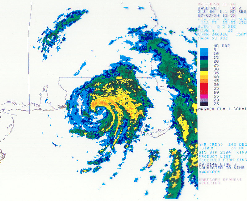
s of 65 miles per hour (104.6 km/h) just as it was making landfall near Destin, Florida
. The storm would have likely attained hurricane status had it been over water just hours longer, as a warm spot was apparent, indicating the formation of an eye
feature. Alberto quickly weakened to a tropical depression over Alabama
as it continued to the northeast, but retained a well-organized circulation. High pressures build to its north and east, causing the remnant tropical depression to stall over northwestern Georgia
. It turned to a west drift, and dissipated over central Alabama on July 7.
; the warning was discontinued on July 1. In the United States, a tropical storm watch was posted on July 2 for locations between Sabine Pass, Texas
and Pensacola, Florida
. The watch was subsequently upgraded to a tropical storm warning from Gulfport, Mississippi
to Cedar Key, Florida
; it was soon altered to a hurricane warning. Later on July 3, the hurricane warning was discontinued in replace of a tropical storm warning, which was lifted at 2100 UTC.
On the Florida Panhandle
, residents boarded up windows in anticipation of what was to be a "fury". At gasoline stations, unusually long lines formed, and local stores did increased business in selling emergency supplies. Thousands of tourists along the coast left the region; a local deputy was quoted as estimating that 10,000 people checked out of their hotels early. On Okaloosa Island
and Holiday Isle, ground-floor house and businesses were forced to evacuate. Civil-defense authorities evacuated residents from low-lying locations. Then-Governor of Florida, Lawton Chiles
, declared a State of emergency
for parts of the state, and advised residents along the coast to monitor updates regarding the storm. Over 3,000 people sought refuge in Red Cross shelters along the coast of Florida, westward into parts of Alabama.
 Upon forming, the storm dropped heavy rainfall over parts of Cuba
, peaking at 10 inches (254 mm).
 At Destin, Florida, sustained winds blew at 63 miles per hour (101.4 km/h), while winds gusted to 75 miles per hour (120.7 km/h); however, there was an unofficial report of 86 miles per hour (138.4 km/h) gusts. There, barometric pressure fell to 993 mb in association with Alberto. Storm tide
s of 5 feet (1.5 m) was estimated along the coast of Destin, while tides reached 3 foot (0.9144 m) at Panama City
. At St. George Island, wind gusts reached 58 miles per hour (93.3 km/h). Beach erosion and tidal flooding occurred along the coast. Throughout northwest Florida, 5 inches (127 mm) of rain fell, with totals as high as 21.57 inches (547.9 mm). Other precipitation accumulations include 13.25 inches (336.6 mm) at Caryville
.
Along the coast, damage was limited to sea walls, piers and boats, and roof damage to some beachfront motels. As the storm progressed inland, it brought down signs, billboards, trees and powerlines, and triggered moderate flooding; about 18,500 customers lost electric power. As a weakened tropical depression, the remnants of Alberto dropped extensive rainfall throughout the region. As heavy rain fell to the north, tremendous volumes of water moved down major river systems into the Florida Panhandle. As a result, there was extensive river flooding that exceeded 100-year events
in some locations, particularly along the Apalachicola
and Chipola River
s. The Apalachicola remained above flood stage until August, although in localized areas, flooding persisted until September due to Tropical Storm Beryl
. A total of 300,000 chickens and 125 cattle
s and hogs were lost within the state, and offshore, 90% of the oysters in Apalachicola Bay were lost. The flooding was severe, inflicting $40 million (1994 USD) in damage to infrastructure, $15 million in insured damage, and $25 million in agricultural losses.
.
Macon, GA - Flood of '94: http://www.hollidaydental.com/Levee1994.htm
declared 30 counties in a state of emergency, which included the following counties in central Georgia: Bibb
, Butts
, Crawford
, Dooly
, Houston
, Jones
, Lamar
, Macon
, Monroe
, Peach
, Sumter
, Taylor
, Twiggs
, and Upson
.
Despite the severe flooding and high property damage toll, the name Alberto was not retired in the spring of 1994.
1994 Atlantic hurricane season
The 1994 Atlantic hurricane seasonofficially began June 1, 1994, and officially ended November 30, 1994. These dates conventionally delimit the period of each year when most tropical cyclones form in the Atlantic basin....
. It hit Florida
Florida
Florida is a state in the southeastern United States, located on the nation's Atlantic and Gulf coasts. It is bordered to the west by the Gulf of Mexico, to the north by Alabama and Georgia and to the east by the Atlantic Ocean. With a population of 18,801,310 as measured by the 2010 census, it...
across the Southeast United States in July, causing a massive flooding disaster while stalling over Georgia
Georgia (U.S. state)
Georgia is a state located in the southeastern United States. It was established in 1732, the last of the original Thirteen Colonies. The state is named after King George II of Great Britain. Georgia was the fourth state to ratify the United States Constitution, on January 2, 1788...
and Alabama
Alabama
Alabama is a state located in the southeastern region of the United States. It is bordered by Tennessee to the north, Georgia to the east, Florida and the Gulf of Mexico to the south, and Mississippi to the west. Alabama ranks 30th in total land area and ranks second in the size of its inland...
. Alberto caused $1 billion in damage (1994 USD) and 30 deaths.
Meteorological history
A tropical wave moved off the coast of AfricaAfrica
Africa is the world's second largest and second most populous continent, after Asia. At about 30.2 million km² including adjacent islands, it covers 6% of the Earth's total surface area and 20.4% of the total land area...
on June 18. It moved westward across the dry, shear-ridden Atlantic Ocean, and remained weak until passing through the Greater Antilles
Greater Antilles
The Greater Antilles are one of three island groups in the Caribbean. Comprising Cuba, Jamaica, Hispaniola , and Puerto Rico, the Greater Antilles constitute almost 90% of the land mass of the entire West Indies.-Greater Antilles in context :The islands of the Caribbean Sea, collectively known as...
. Deep convection developed over the wave in response to light vertical shear and warm waters of the Caribbean Sea, and organized into Tropical Depression One near the Isle of Youth
Isle of Youth
Isla de la Juventud is the second-largest Cuban island and the seventh-largest island in the West Indies . The island has an area and is 100 km south of the island of Cuba, across the Gulf of Batabanó...
on June 30. A trough of low pressure brought the depression to the northwest over the Gulf of Mexico
Gulf of Mexico
The Gulf of Mexico is a partially landlocked ocean basin largely surrounded by the North American continent and the island of Cuba. It is bounded on the northeast, north and northwest by the Gulf Coast of the United States, on the southwest and south by Mexico, and on the southeast by Cuba. In...
, remaining weak due to increased upper level shear. The shear abated, allowing the depression to strengthen into Tropical Storm Alberto on July 2.
Alberto continued to the north-northeast in response to a short wave trough, and steadily strengthened as the convection became embedded around the center. Tropical Storm Alberto peaked with maximum sustained wind
Maximum sustained wind
The maximum sustained winds associated with a tropical cyclone are a common indicator of the intensity of the storm. Within a mature tropical cyclone, they are found within the eyewall at a distance defined as the radius of maximum wind, or RMW. Unlike gusts, the value of these winds are...
s of 65 miles per hour (104.6 km/h) just as it was making landfall near Destin, Florida
Destin, Florida
Destin is a city located in Okaloosa County, Florida. It is a principal city of the Fort Walton Beach-Crestview-Destin, Florida Metropolitan Statistical Area.Located on Florida's Emerald Coast, Destin is known for its white beaches and emerald green waters...
. The storm would have likely attained hurricane status had it been over water just hours longer, as a warm spot was apparent, indicating the formation of an eye
Eye (cyclone)
The eye is a region of mostly calm weather found at the center of strong tropical cyclones. The eye of a storm is a roughly circular area and typically 30–65 km in diameter. It is surrounded by the eyewall, a ring of towering thunderstorms where the second most severe weather of a cyclone...
feature. Alberto quickly weakened to a tropical depression over Alabama
Alabama
Alabama is a state located in the southeastern region of the United States. It is bordered by Tennessee to the north, Georgia to the east, Florida and the Gulf of Mexico to the south, and Mississippi to the west. Alabama ranks 30th in total land area and ranks second in the size of its inland...
as it continued to the northeast, but retained a well-organized circulation. High pressures build to its north and east, causing the remnant tropical depression to stall over northwestern Georgia
Georgia (U.S. state)
Georgia is a state located in the southeastern United States. It was established in 1732, the last of the original Thirteen Colonies. The state is named after King George II of Great Britain. Georgia was the fourth state to ratify the United States Constitution, on January 2, 1788...
. It turned to a west drift, and dissipated over central Alabama on July 7.
Preparations
On June 30, on the day of Alberto's formation, a tropical storm warning was issued from Puerto Juárez to Mérida, MexicoMérida, Yucatán
Mérida is the capital and largest city of the Mexican state of Yucatán and the Yucatán Peninsula. It is located in the northwest part of the state, about from the Gulf of Mexico coast...
; the warning was discontinued on July 1. In the United States, a tropical storm watch was posted on July 2 for locations between Sabine Pass, Texas
Sabine Pass, Texas
Sabine Pass is a neighborhood of Port Arthur, Texas, United States. It lies on the west bank of Sabine Pass, near the Louisiana border.Originally known as Sabine City, the original date of settlement of Sabine Pass is unknown, but is estimated at 1836...
and Pensacola, Florida
Pensacola, Florida
Pensacola is the westernmost city in the Florida Panhandle and the county seat of Escambia County, Florida, United States of America. As of the 2000 census, the city had a total population of 56,255 and as of 2009, the estimated population was 53,752...
. The watch was subsequently upgraded to a tropical storm warning from Gulfport, Mississippi
Gulfport, Mississippi
Gulfport is the second largest city in Mississippi after the state capital Jackson. It is the larger of the two principal cities of the Gulfport-Biloxi, Mississippi Metropolitan Statistical Area, which is included in the Gulfport-Biloxi-Pascagoula, Mississippi Combined Statistical Area. As of the...
to Cedar Key, Florida
Cedar Key, Florida
Cedar Key is a city in Levy County, Florida, United States. The population was 790 at the 2000 census. According to the U.S Census estimates of 2005, the city had a population of 958. The Cedar Keys are a cluster of islands close to the mainland. Most of the developed area of the city has been on...
; it was soon altered to a hurricane warning. Later on July 3, the hurricane warning was discontinued in replace of a tropical storm warning, which was lifted at 2100 UTC.
On the Florida Panhandle
Florida Panhandle
The Florida Panhandle, an informal, unofficial term for the northwestern part of Florida, is a strip of land roughly 200 miles long and 50 to 100 miles wide , lying between Alabama on the north and the west, Georgia also on the north, and the Gulf of Mexico to the south. Its eastern boundary is...
, residents boarded up windows in anticipation of what was to be a "fury". At gasoline stations, unusually long lines formed, and local stores did increased business in selling emergency supplies. Thousands of tourists along the coast left the region; a local deputy was quoted as estimating that 10,000 people checked out of their hotels early. On Okaloosa Island
Okaloosa Island
Okaloosa Island is a regionally used term for a small section of larger Santa Rosa Island located in Okaloosa County, Florida. Okaloosa Island is home to hundreds of residential homes, high rise condominiums and major hotels and motels. The area is unincorporated and uses Fort Walton Beach as a...
and Holiday Isle, ground-floor house and businesses were forced to evacuate. Civil-defense authorities evacuated residents from low-lying locations. Then-Governor of Florida, Lawton Chiles
Lawton Chiles
Lawton Mainor Chiles, Jr. was an American politician from the US state of Florida. In a career spanning four decades, Chiles, a Democrat who never lost an election, served in the Florida House of Representatives , the Florida State Senate , the United States Senate , and as the 41st Governor of...
, declared a State of emergency
State of emergency
A state of emergency is a governmental declaration that may suspend some normal functions of the executive, legislative and judicial powers, alert citizens to change their normal behaviours, or order government agencies to implement emergency preparedness plans. It can also be used as a rationale...
for parts of the state, and advised residents along the coast to monitor updates regarding the storm. Over 3,000 people sought refuge in Red Cross shelters along the coast of Florida, westward into parts of Alabama.
Impact
Cuba
The Republic of Cuba is an island nation in the Caribbean. The nation of Cuba consists of the main island of Cuba, the Isla de la Juventud, and several archipelagos. Havana is the largest city in Cuba and the country's capital. Santiago de Cuba is the second largest city...
, peaking at 10 inches (254 mm).
Florida
Storm surge
A storm surge is an offshore rise of water associated with a low pressure weather system, typically tropical cyclones and strong extratropical cyclones. Storm surges are caused primarily by high winds pushing on the ocean's surface. The wind causes the water to pile up higher than the ordinary sea...
s of 5 feet (1.5 m) was estimated along the coast of Destin, while tides reached 3 foot (0.9144 m) at Panama City
Panama City, Florida
-Personal income:The median income for a household in the city was $31,572, and the median income for a family was $40,890. Males had a median income of $30,401 versus $21,431 for females. The per capita income for the city was $17,830...
. At St. George Island, wind gusts reached 58 miles per hour (93.3 km/h). Beach erosion and tidal flooding occurred along the coast. Throughout northwest Florida, 5 inches (127 mm) of rain fell, with totals as high as 21.57 inches (547.9 mm). Other precipitation accumulations include 13.25 inches (336.6 mm) at Caryville
Caryville, Florida
Caryville is a town in Washington County, Florida, United States. The population was 218 at the 2000 census.-Geography:Caryville is located at .According to the United States Census Bureau, the town has a total area of...
.
Along the coast, damage was limited to sea walls, piers and boats, and roof damage to some beachfront motels. As the storm progressed inland, it brought down signs, billboards, trees and powerlines, and triggered moderate flooding; about 18,500 customers lost electric power. As a weakened tropical depression, the remnants of Alberto dropped extensive rainfall throughout the region. As heavy rain fell to the north, tremendous volumes of water moved down major river systems into the Florida Panhandle. As a result, there was extensive river flooding that exceeded 100-year events
100-year flood
A one-hundred-year flood is calculated to be the level of flood water expected to be equaled or exceeded every 100 years on average. The 100-year flood is more accurately referred to as the 1% annual exceedance probability flood, since it is a flood that has a 1% chance of being equaled or exceeded...
in some locations, particularly along the Apalachicola
Apalachicola River
The Apalachicola River is a river, approximately 112 mi long in the State of Florida. This river's large watershed, known as the ACF River Basin for short, drains an area of approximately into the Gulf of Mexico. The distance to its farthest headstream in northeast Georgia is approximately 500...
and Chipola River
Chipola River
The Chipola River is a tributary of the Apalachicola River in Florida. The river crosses Jackson, Calhoun and Gulf counties. The river flows into the Dead Lakes State Recreation Area just before reaching the Apalachicola. The Dead Lakes were formed when the Apalachicola deposited sand bars...
s. The Apalachicola remained above flood stage until August, although in localized areas, flooding persisted until September due to Tropical Storm Beryl
Tropical Storm Beryl (1994)
Tropical Storm Beryl, was the second named storm of the 1994 Atlantic hurricane season. Beryl originated north of Puerto Rico as an upper-level low pressure system, then passed over Florida, then entered the gulf where it became a tropical depression. The storm had advisories on it for five days;...
. A total of 300,000 chickens and 125 cattle
Cattle
Cattle are the most common type of large domesticated ungulates. They are a prominent modern member of the subfamily Bovinae, are the most widespread species of the genus Bos, and are most commonly classified collectively as Bos primigenius...
s and hogs were lost within the state, and offshore, 90% of the oysters in Apalachicola Bay were lost. The flooding was severe, inflicting $40 million (1994 USD) in damage to infrastructure, $15 million in insured damage, and $25 million in agricultural losses.
Georgia
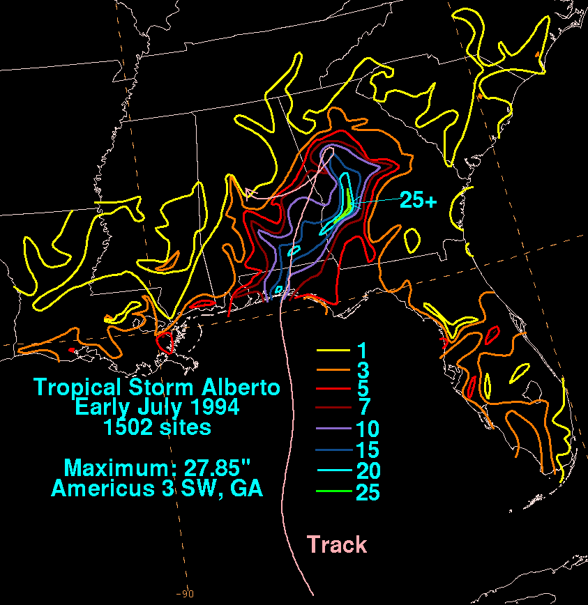
While Alberto remained nearly stationary over western Georgia, torrential rainfall amount were observed, with much that portion of the state experience at least seven in (178 mm). Southeast of the path of Tropical Depression Alberto, rainfall was measured at much greater amounts, and precipitation from the tropical cyclone peaked at 27.85 in (707 mm) near Americus, GeorgiaAmericus, Georgia
-Early years:Americus, Georgia was named and chartered by Sen. Lovett B. Smith in 1832.For its first two decades, Americus was a small courthouse town. The arrival of the railroad in 1854 and, three decades later, local attorney Samuel H. Hawkins' construction of the only privately financed...
.
Macon, GA - Flood of '94: http://www.hollidaydental.com/Levee1994.htm
Aftermath
Because of the severe flooding in the state of Georgia, then-governor Zell MillerZell Miller
Zell Bryan Miller is an American politician from the US state of Georgia. A Democrat, Miller served as Lieutenant Governor from 1975 to 1991, 79th Governor of Georgia from 1991 to 1999, and as United States Senator from 2000 to 2005....
declared 30 counties in a state of emergency, which included the following counties in central Georgia: Bibb
Bibb County, Georgia
Bibb County is a county located in the U.S. state of Georgia. As of 2000, the population was 153,887. The 2007 Census Estimate shows a population of 154,709...
, Butts
Butts County, Georgia
Butts County is a county located in the northern half of the U.S. state of Georgia. It was created on December 24, 1825. As of 2000, the population was 19,522. The 2007 Census Estimate showed a population of 23,759...
, Crawford
Crawford County, Georgia
Crawford County is a county located in the U.S. state of Georgia. As of 2000, the population was 12,495. The 2007 Census Estimate shows a population of 12,483. The unincorporated county seat is Knoxville.-History:...
, Dooly
Dooly County, Georgia
Dooly County is a county located in the U.S. state of Georgia. As of 2000, the population was 11,525. The 2007 Census Estimate shows a population of 11,592. The county seat is Vienna....
, Houston
Houston County, Georgia
Houston County is a county located in the U.S. state of Georgia. It was created on May 15, 1821, as one of five huge counties, later reduced in the formation of Bibb, Crawford, Pike, Macon and Peach counties. As of the 2000 census, the population is 110,765...
, Jones
Jones County, Georgia
Jones County is a county located in the U.S. state of Georgia. It was created on December 10, 1807. As of 2010, the population was 27,740 . The county seat is Gray.-History:The county is named after U.S...
, Lamar
Lamar County, Georgia
Lamar County is a county located in the U.S. state of Georgia. As of 2000, the population was 15,912. The 2007 Census Estimate shows a population of 16,961...
, Macon
Macon County, Georgia
Macon County is a county located in the U.S. state of Georgia. As of the 2000 census, the population was 14,074. The 2007 Census Estimate shows a population of 13,542. The county seat is Oglethorpe.-History:...
, Monroe
Monroe County, Georgia
Monroe County is a county located in the U.S. state of Georgia. It was created on May 15, 1821. As of 2000, the population was 21,757. The 2007 Census Estimate showed a population of 25,145...
, Peach
Peach County, Georgia
Peach County is a county located in the U.S. state of Georgia. As of the 2000 census, the population was 23,668. The 2007 Census Estimate showed a population of 25,672. Its county seat is Fort Valley....
, Sumter
Sumter County, Georgia
Sumter County is a county located in the southwest portion of the U.S. state of Georgia. It was created on December 26, 1831. As of 2000, the population was 33,200. The 2007 Census Estimate shows a population of 32,532...
, Taylor
Taylor County, Georgia
Taylor County is a county located in the U.S. state of Georgia. As of 2000, the population was 8,815. The 2007 Census Estimate shows a population of 8,738...
, Twiggs
Twiggs County, Georgia
Twiggs County is a county located in the U.S. state of Georgia. It was created on December 14, 1809. As of 2000, the population was 10,590. The 2007 Census Estimate shows a population of 10,280...
, and Upson
Upson County, Georgia
Upson County is a county located in the U.S. state of Georgia. It is a part of the Atlanta Metropolitan Area . It was created on December 15, 1824. As of 2000, the population was 27,597. The 2007 Census Estimate shows a population of 27,562...
.
Despite the severe flooding and high property damage toll, the name Alberto was not retired in the spring of 1994.
See also
- Other storms of the same nameHurricane AlbertoThe name Alberto has been used for five tropical cyclones in the Atlantic Ocean:*Hurricane Alberto , a Category 1 hurricane that formed near Cuba, where it caused 23 deaths from heavy flooding...
- List of wettest tropical cyclones in the United States
- List of floods
- List of Florida hurricanes (1975-1999)
- Timeline of the 1994 Atlantic hurricane seasonTimeline of the 1994 Atlantic hurricane seasonThe 1994 Atlantic hurricane season was a below-average Atlantic hurricane season that produced seven named tropical cyclones. The season officially began on June 1 and ended on November 30, dates which conventionally limit the period of each year when tropical cyclones tend to form in the Atlantic....
External links
- [ftp://ftp.nhc.noaa.gov/pub/storm_archives/atlantic/prelimat/atl1994/alberto/ NHC Alberto report]
- NWS Service Assessment