
.gif)
Hurricane Bob (1985)
Encyclopedia
Hurricane Bob was a hurricane
that affected the southeast United States
in July 1985. The second tropical storm and first hurricane of the 1985 Atlantic hurricane season
, the system developed from a tropical wave
on July 21 in the eastern Gulf of Mexico
. Bob began moving east, striking southwestern Florida
as a weak tropical storm. The storm then turned to the north and quickly intensified to hurricane status on July 24. The next day, it made landfall near Beaufort, South Carolina
, becoming one of a record-tying six hurricanes to hit the United States during a single season. Bob quickly weakened over land, and was absorbed by a frontal trough
over eastern West Virginia
on July 26.
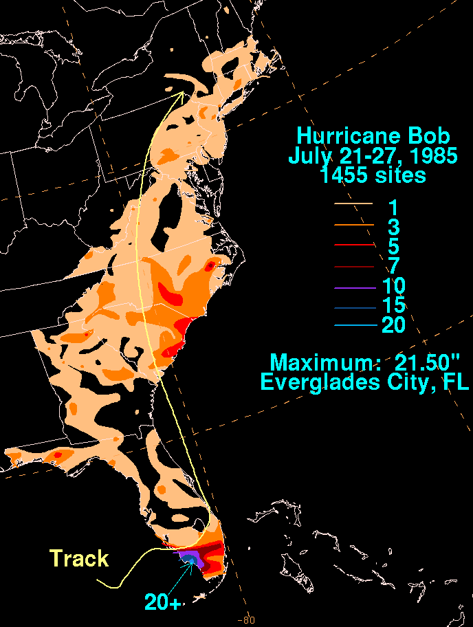
Bob caused $20 million in damage and five indirect deaths. In Florida, the storm produced heavy rainfall, peaking at over 20 inches (508 mm) in Everglades City. In most areas, the rainfall was beneficial due to dry conditions that had persisted throughout the year. Damage was minimal in South Carolina, where the hurricane made its final landfall. In Virginia, the storm spawned three tornado
es, one of which destroyed two houses.
entered the eastern Gulf of Mexico
on July 20. An area of low pressure
formed and developed into a tropical depression on July 21. Under weak steering currents, the tropical depression drifted southeast, then turned northeast and later east. Based on reports from Hurricane Hunters
, the system intensified into Tropical Storm Bob late on July 22. Bob failed to organize significantly as it tracked east through the Gulf, and made landfall between Naples and Fort Myers, Florida
on July 23 as a 45 mph (72.4 km/h) tropical storm. At the time, most of the convection
was concentrated south and east of the center.
While moving across Florida, Bob turned to the northeast, then to the north. It subsequently left the peninsula, entering the Atlantic Ocean near Vero Beach
early on July 24. As it moved over the warm waters of the Gulf Stream
, it quickly organized and intensified into a Category 1 hurricane
while 70 mi (112.7 km) east of Jacksonville, Florida
. Because it was embedded within the western extension of the subtropical ridge
, Bob retained higher-than-average atmospheric pressure
s throughout its lifespan. The hurricane continued north, and made landfall near Beaufort, South Carolina
early on July 25 while maintaining winds of 75 mph (120.7 km/h). Bob quickly weakened over land, decaying into a tropical storm three hours after landfall. About 12 hours later, it degenerated into a tropical depression near the North Carolina
– Virginia
border. Bob's remnants turned north-northeast, and were absorbed by a frontal trough
over eastern West Virginia
on July 26. An associated area of disturbed weather remained separate from the trough, and continued northeast through the Mid-Atlantic
and New England
.
issued gale warning
s for the Florida Keys
west of Craig Key
, and from Flamingo
to Venice
. Gale warnings were later posted for the Atlantic coast of Florida northward through St. Augustine
. Small craft south of St. Augustine were advised to remain in port. While the storm was situated off the east-central coast of Florida, the National Hurricane Center
issued a gale warning and a hurricane watch
from Savannah, Georgia
to Little River, South Carolina
. The hurricane watch was upgraded to a hurricane warning after Bob's intensification to Category 1 status.
Thousands of residents evacuated coastal areas of South Carolina, many of whom stayed at inland hotels; 850 people sought protection in shelters, including 500 at an elementary school in Horry County
and 240 in a shelter in the Grand Strand
. In Beaufort County
, city and county offices were closed early and businesses were advised to send their workers home prematurely. Officials in Chatham County, Georgia
evacuated nursing homes on Tybee Island
, and encouraged others to leave due to the potential for high tides to isolate the island by cutting off U.S. Route 80
.
during the 1991 season.
.jpg) In southern Florida, the heaviest rainfall remained to the south and east of the storm's center; 21.5 inches (546 mm) of precipitation was recorded in Everglades City. Northern parts of the state reported trace amounts to several inches of precipitation. At Naples
In southern Florida, the heaviest rainfall remained to the south and east of the storm's center; 21.5 inches (546 mm) of precipitation was recorded in Everglades City. Northern parts of the state reported trace amounts to several inches of precipitation. At Naples
, sustained winds reached 40 mph (64.4 km/h), with a peak gust of 58 mph (93.3 km/h). Rough surf and above-average tides caused moderate to severe beach erosion in portions of coastal Manatee
, Sarasota
, and Charlotte
counties. Before landfall, Tropical Storm Bob spawned an F0
tornado in Brevard County
that caused $2,500 in damage (1985 USD, $4,700 2006 USD) along its 1 miles (1.6 km) path.
Tropical Storm Bob flooded roads and downed trees in Florida. Rough seas broke over sea walls in southwestern parts of the state, and the combination of high tides and heavy rain caused forced the closure of causeways to Sanibel Island
and Marco Island, leaving the islands temporarily isolated. They were re-opened when the waters receded, though the causeway to Sanibel Island sustained some damage. Florida Power & Light Co. reported that 1,200 to 1,500 residences were without power on July 23. In Palm Beach County
, rainfall from the storm caused agricultural damage.
Overall damage was minimal and primarily confined to minor property near the coast. The storm's rainfall was beneficial in areas that had suffered dry conditions. In northeastern Florida and Georgia
, beach erosion occurred along the coast. Bob was one of four July tropical cyclones to affect Palm Beach County since 1878.
 The strongest winds from Hurricane Bob were confined to areas east of its center when it came ashore around 1 am Eastern Standard Time
(EST). Along the barrier islands off the coast of Charleston, windows were broken and power lines knocked down. Further inland, the lack of damage in spite of high winds was described as "almost unbelievable". Georgetown, South Carolina
, 105 miles (169 km) northeast of where the storm made landfall, recorded sustained winds of 58 mph (93.3 km/h), and a spiral rainband
produced a peak wind gust of 83 mph (133.6 km/h) in Holden Beach
. Upon moving ashore, the hurricane produced an estimated storm tide of 2.6 foot (0.79248 m) in Edisto Beach
. Rainfall in the Carolinas was moderate; portions of coastal South Carolina received over 5 inches (127 mm) of precipitation. Myrtle Beach
reported a statewide peak of 7.79 inches (197.9 mm). Hurricane-force wind gusts downed trees and power lines, leaving over 32,000 people without power, including more than 25,000 in the Charleston
area. Near the coast, high winds shattered windows.
Strong waves broke over sea walls in Charleston, spilling floodwaters onto coastal streets and homes. Damage in the state was relatively light, and no serious injuries were reported. However, a gas station in Folly Beach
was torn apart by the winds, and some structures along the coast sustained roof damage. In the Charleston Harbor
, an empty tanker
was forced aground on a sandbar by the winds. Throughout most areas, the storm was insignificant; a police sergeant in Summerville
commented, "All we've had were some trees blown over, hardly enough to make it worth staying up so late."
Much of North Carolina
received over 1 inches (25.4 mm) of rain; as much as 7 inches (178 mm) fell in Beaufort County
. The storm caused one traffic-related fatality in the state.
, a large band of thunderstorms associated with the hurricane brought strong winds and spawned three tornado
es. A funnel cloud
formed in Albemarle County
evolved into an F3
tornado after crossing into Greene County
. It destroyed two houses and uprooted several trees, inflicting $250,000 in damage (1985 USD, $470,000 2006 USD). F0 tornadoes were also generated in Goochland County
and Hanover County
; the two tornadoes damaged a total of ten houses. Funnel clouds were sighted throughout the Baltimore-Washington Metropolitan Area
.
Heavy precipitation and high winds disrupted the 1985 Boy Scouts of America
National Scout Jamboree at Fort A. P. Hill near Fredericksburg, Virginia
, knocking over hundreds of tents and fifty portable toilet
s. One scout was struck by a falling gateway and several others sustained minor cuts and bruises. The storm produced winds of 48 mph (77.2 km/h) at the Ronald Reagan Washington National Airport
, and about 30,000 people near Washington, D.C. and 125,000 in Baltimore were left without power. Moderate winds downed a sea plane near Hains Point
in the Washington Channel
. Rough seas capsized a few boats along the Potomac River
, and rainfall from Bob's remnants forced the cancellation of a Richmond Braves
game. and collapsed a house under construction in Great Falls, Maryland. A dam in Northeastern Virginia sustained storm-related damage. Slick roads led to several traffic accidents; one person in Washington, D.C. and three in Maryland were killed. High winds in the Washington, DC area also flipped over a pontoon-equipped Cessna 210
airplane near Hains Point
, holding a five-man television crew. The crew, who worked for the television series Lime Street had been preparing to film a chase scene for the television drama. All five escaped the plane safely with the aid of the Metropolitan Police Department of the District of Columbia
harbor patrol.
Rainfall in the Mid-Atlantic
and New England
states was around 1 inches (25.4 mm), with isolated reports of over 3 inches (76.2 mm). About 0.5 inches (13 mm) of precipitation fell in Atlantic City, New Jersey
within a period of 10 minutes. In Maryland
, the rainfall helped to relieve persistent dry conditions.
Tropical cyclone
A tropical cyclone is a storm system characterized by a large low-pressure center and numerous thunderstorms that produce strong winds and heavy rain. Tropical cyclones strengthen when water evaporated from the ocean is released as the saturated air rises, resulting in condensation of water vapor...
that affected the southeast United States
Southeastern United States
The Southeastern United States, colloquially referred to as the Southeast, is the eastern portion of the Southern United States. It is one of the most populous regions in the United States of America....
in July 1985. The second tropical storm and first hurricane of the 1985 Atlantic hurricane season
1985 Atlantic hurricane season
The 1985 Atlantic hurricane season had the most U.S. landfalling tropical cyclones since 1916. The season officially began on June 1, 1985, and lasted until November 30, 1985...
, the system developed from a tropical wave
Tropical wave
Tropical waves, easterly waves, or tropical easterly waves, also known as African easterly waves in the Atlantic region, are a type of atmospheric trough, an elongated area of relatively low air pressure, oriented north to south, which move from east to west across the tropics causing areas of...
on July 21 in the eastern Gulf of Mexico
Gulf of Mexico
The Gulf of Mexico is a partially landlocked ocean basin largely surrounded by the North American continent and the island of Cuba. It is bounded on the northeast, north and northwest by the Gulf Coast of the United States, on the southwest and south by Mexico, and on the southeast by Cuba. In...
. Bob began moving east, striking southwestern Florida
Florida
Florida is a state in the southeastern United States, located on the nation's Atlantic and Gulf coasts. It is bordered to the west by the Gulf of Mexico, to the north by Alabama and Georgia and to the east by the Atlantic Ocean. With a population of 18,801,310 as measured by the 2010 census, it...
as a weak tropical storm. The storm then turned to the north and quickly intensified to hurricane status on July 24. The next day, it made landfall near Beaufort, South Carolina
Beaufort, South Carolina
Beaufort is a city in and the county seat of Beaufort County, South Carolina, United States. Chartered in 1711, it is the second-oldest city in South Carolina, behind Charleston. The city's population was 12,361 in the 2010 census. It is located in the Hilton Head Island-Beaufort Micropolitan...
, becoming one of a record-tying six hurricanes to hit the United States during a single season. Bob quickly weakened over land, and was absorbed by a frontal trough
Trough (meteorology)
A trough is an elongated region of relatively low atmospheric pressure, often associated with fronts.Unlike fronts, there is not a universal symbol for a trough on a weather chart. The weather charts in some countries or regions mark troughs by a line. In the United States, a trough may be marked...
over eastern West Virginia
West Virginia
West Virginia is a state in the Appalachian and Southeastern regions of the United States, bordered by Virginia to the southeast, Kentucky to the southwest, Ohio to the northwest, Pennsylvania to the northeast and Maryland to the east...
on July 26.
Bob caused $20 million in damage and five indirect deaths. In Florida, the storm produced heavy rainfall, peaking at over 20 inches (508 mm) in Everglades City. In most areas, the rainfall was beneficial due to dry conditions that had persisted throughout the year. Damage was minimal in South Carolina, where the hurricane made its final landfall. In Virginia, the storm spawned three tornado
Tornado
A tornado is a violent, dangerous, rotating column of air that is in contact with both the surface of the earth and a cumulonimbus cloud or, in rare cases, the base of a cumulus cloud. They are often referred to as a twister or a cyclone, although the word cyclone is used in meteorology in a wider...
es, one of which destroyed two houses.
Meteorological history
The remnants of a tropical waveTropical wave
Tropical waves, easterly waves, or tropical easterly waves, also known as African easterly waves in the Atlantic region, are a type of atmospheric trough, an elongated area of relatively low air pressure, oriented north to south, which move from east to west across the tropics causing areas of...
entered the eastern Gulf of Mexico
Gulf of Mexico
The Gulf of Mexico is a partially landlocked ocean basin largely surrounded by the North American continent and the island of Cuba. It is bounded on the northeast, north and northwest by the Gulf Coast of the United States, on the southwest and south by Mexico, and on the southeast by Cuba. In...
on July 20. An area of low pressure
Low pressure area
A low-pressure area, or "low", is a region where the atmospheric pressure at sea level is below that of surrounding locations. Low-pressure systems form under areas of wind divergence which occur in upper levels of the troposphere. The formation process of a low-pressure area is known as...
formed and developed into a tropical depression on July 21. Under weak steering currents, the tropical depression drifted southeast, then turned northeast and later east. Based on reports from Hurricane Hunters
Hurricane Hunters
The Hurricane Hunters are aircraft that fly into tropical cyclones in the North Atlantic Ocean and Northeastern Pacific Ocean for the specific purpose of directly measuring weather data in and around those storms. In the United States, the Air Force, Navy, and NOAA units have all participated in...
, the system intensified into Tropical Storm Bob late on July 22. Bob failed to organize significantly as it tracked east through the Gulf, and made landfall between Naples and Fort Myers, Florida
Fort Myers, Florida
Fort Myers is the county seat and commercial center of Lee County, Florida, United States. Its population was 62,298 in the 2010 census, a 29.23 percent increase over the 2000 figure....
on July 23 as a 45 mph (72.4 km/h) tropical storm. At the time, most of the convection
Atmospheric convection
Atmospheric convection is the result of a parcel-environment instability, or temperature difference, layer in the atmosphere. Different lapse rates within dry and moist air lead to instability. Mixing of air during the day which expands the height of the planetary boundary layer leads to...
was concentrated south and east of the center.
While moving across Florida, Bob turned to the northeast, then to the north. It subsequently left the peninsula, entering the Atlantic Ocean near Vero Beach
Vero Beach, Florida
Vero Beach is a city in Indian River County, Florida, USA. According to the U.S. Census Bureau's 2006 estimates, the city had a population of 16,939. It is the county seat of Indian River County...
early on July 24. As it moved over the warm waters of the Gulf Stream
Gulf Stream
The Gulf Stream, together with its northern extension towards Europe, the North Atlantic Drift, is a powerful, warm, and swift Atlantic ocean current that originates at the tip of Florida, and follows the eastern coastlines of the United States and Newfoundland before crossing the Atlantic Ocean...
, it quickly organized and intensified into a Category 1 hurricane
Saffir-Simpson Hurricane Scale
The Saffir–Simpson Hurricane Scale , or the Saffir–Simpson Hurricane Wind Scale , classifies hurricanes — Western Hemisphere tropical cyclones that exceed the intensities of tropical depressions and tropical storms — into five categories distinguished by the intensities of their sustained winds...
while 70 mi (112.7 km) east of Jacksonville, Florida
Jacksonville, Florida
Jacksonville is the largest city in the U.S. state of Florida in terms of both population and land area, and the largest city by area in the contiguous United States. It is the county seat of Duval County, with which the city government consolidated in 1968...
. Because it was embedded within the western extension of the subtropical ridge
Subtropical ridge
The subtropical ridge is a significant belt of high pressure situated around the latitudes of 30°N in the Northern Hemisphere and 30°S in the Southern Hemisphere. It is characterized by mostly calm winds, which acts to reduce air quality under its axis by causing fog overnight, and haze during...
, Bob retained higher-than-average atmospheric pressure
Atmospheric pressure
Atmospheric pressure is the force per unit area exerted into a surface by the weight of air above that surface in the atmosphere of Earth . In most circumstances atmospheric pressure is closely approximated by the hydrostatic pressure caused by the weight of air above the measurement point...
s throughout its lifespan. The hurricane continued north, and made landfall near Beaufort, South Carolina
Beaufort, South Carolina
Beaufort is a city in and the county seat of Beaufort County, South Carolina, United States. Chartered in 1711, it is the second-oldest city in South Carolina, behind Charleston. The city's population was 12,361 in the 2010 census. It is located in the Hilton Head Island-Beaufort Micropolitan...
early on July 25 while maintaining winds of 75 mph (120.7 km/h). Bob quickly weakened over land, decaying into a tropical storm three hours after landfall. About 12 hours later, it degenerated into a tropical depression near the North Carolina
North Carolina
North Carolina is a state located in the southeastern United States. The state borders South Carolina and Georgia to the south, Tennessee to the west and Virginia to the north. North Carolina contains 100 counties. Its capital is Raleigh, and its largest city is Charlotte...
– Virginia
Virginia
The Commonwealth of Virginia , is a U.S. state on the Atlantic Coast of the Southern United States. Virginia is nicknamed the "Old Dominion" and sometimes the "Mother of Presidents" after the eight U.S. presidents born there...
border. Bob's remnants turned north-northeast, and were absorbed by a frontal trough
Trough (meteorology)
A trough is an elongated region of relatively low atmospheric pressure, often associated with fronts.Unlike fronts, there is not a universal symbol for a trough on a weather chart. The weather charts in some countries or regions mark troughs by a line. In the United States, a trough may be marked...
over eastern West Virginia
West Virginia
West Virginia is a state in the Appalachian and Southeastern regions of the United States, bordered by Virginia to the southeast, Kentucky to the southwest, Ohio to the northwest, Pennsylvania to the northeast and Maryland to the east...
on July 26. An associated area of disturbed weather remained separate from the trough, and continued northeast through the Mid-Atlantic
Mid-Atlantic States
The Mid-Atlantic states, also called middle Atlantic states or simply the mid Atlantic, form a region of the United States generally located between New England and the South...
and New England
New England
New England is a region in the northeastern corner of the United States consisting of the six states of Maine, New Hampshire, Vermont, Massachusetts, Rhode Island, and Connecticut...
.
Preparations
When Bob was designated a tropical storm, the National Hurricane CenterNational Hurricane Center
The National Hurricane Center , located at Florida International University in Miami, Florida, is the division of the National Weather Service responsible for tracking and predicting weather systems within the tropics between the Prime Meridian and the 140th meridian west poleward to the 30th...
issued gale warning
Gale warning
A gale warning is a warning issued by weather services in maritime locations about the existence of winds of gale force or above or the imminent occurrence of gales at sea...
s for the Florida Keys
Florida Keys
The Florida Keys are a coral archipelago in southeast United States. They begin at the southeastern tip of the Florida peninsula, about south of Miami, and extend in a gentle arc south-southwest and then westward to Key West, the westernmost of the inhabited islands, and on to the uninhabited Dry...
west of Craig Key
Craig Key
Craig Key is an island in the middle Florida Keys.U.S. 1 crosses the key at approximately mile marker 72, between Lower Matecumbe Key and Fiesta Key.-History:...
, and from Flamingo
Flamingo, Florida
Flamingo is an unincorporated community and ghost town in Monroe County, Florida, United States. It began as a small coastal settlement on the eastern end of Cape Sable on the southern tip of the Florida peninsula, facing Florida Bay...
to Venice
Venice, Florida
Venice is a city in Sarasota County, Florida, United States. According to the U.S. Census Bureau's 2007 estimates, the city had a population of 21,015. It is noted for its large snowbird population. Its newspaper is the Venice Gondolier Sun...
. Gale warnings were later posted for the Atlantic coast of Florida northward through St. Augustine
St. Augustine, Florida
St. Augustine is a city in the northeast section of Florida and the county seat of St. Johns County, Florida, United States. Founded in 1565 by Spanish explorer and admiral Pedro Menéndez de Avilés, it is the oldest continuously occupied European-established city and port in the continental United...
. Small craft south of St. Augustine were advised to remain in port. While the storm was situated off the east-central coast of Florida, the National Hurricane Center
National Hurricane Center
The National Hurricane Center , located at Florida International University in Miami, Florida, is the division of the National Weather Service responsible for tracking and predicting weather systems within the tropics between the Prime Meridian and the 140th meridian west poleward to the 30th...
issued a gale warning and a hurricane watch
Tropical cyclone warnings and watches
Warnings and watches are two levels of alert issued by national weather forecasting bodies to coastal areas threatened by the imminent approach of a tropical cyclone of tropical storm or hurricane intensity. They are notices to the local population and civil authorities to make appropriate...
from Savannah, Georgia
Savannah, Georgia
Savannah is the largest city and the county seat of Chatham County, in the U.S. state of Georgia. Established in 1733, the city of Savannah was the colonial capital of the Province of Georgia and later the first state capital of Georgia. Today Savannah is an industrial center and an important...
to Little River, South Carolina
Little River, South Carolina
Little River is a census-designated place in Horry County, South Carolina, United States. The population was 7,027 at the 2000 census....
. The hurricane watch was upgraded to a hurricane warning after Bob's intensification to Category 1 status.
Thousands of residents evacuated coastal areas of South Carolina, many of whom stayed at inland hotels; 850 people sought protection in shelters, including 500 at an elementary school in Horry County
Horry County, South Carolina
Horry County is a county located in the U.S. state of South Carolina. This name honored Revolutionary War Hero, Peter Horry. Brigadier General Horry was born in South Carolina sometime around 1743 and started his distinguished military career in 1775 as one of 20 captains the Provincial Congress...
and 240 in a shelter in the Grand Strand
Grand Strand
The Grand Strand refers to a large stretch of beaches on the East Coast of the United States extending from Little River to Georgetown in the U.S. State of South Carolina. It consists of 60+ miles along an essentially uninterrupted arc of beach land, beginning around the Little River and...
. In Beaufort County
Beaufort County, South Carolina
-National protected areas:*Ernest F. Hollings ACE Basin National Wildlife Refuge *Pinckney Island National Wildlife Refuge-Demographics:As of the census of 2000, there were 155,215 people, 45,532 households, and 33,056 families residing in the county. The population density was 206 people per...
, city and county offices were closed early and businesses were advised to send their workers home prematurely. Officials in Chatham County, Georgia
Chatham County, Georgia
Chatham County is a county located in the U.S. state of Georgia. The county seat and largest city is Savannah. In the official US Census of 2010, Chatham County had a total population of 265,128 . Chatham is the most populous Georgia county outside the Atlanta metropolitan area...
evacuated nursing homes on Tybee Island
Tybee Island, Georgia
Tybee Island is an island and city in Chatham County, Georgia near the city of Savannah in the southeastern United States. It is the easternmost point in the state of Georgia. As of the 2010 census, the city population was 2,990. Tybee Island is an island and city in Chatham County, Georgia near...
, and encouraged others to leave due to the potential for high tides to isolate the island by cutting off U.S. Route 80
U.S. Route 80
U.S. Route 80 is an east–west United States highway, much of which was once part of the early auto trail known as the Dixie Overland Highway. As the "0" in the route number indicates, it was originally a cross-country route, from the Atlantic to the Pacific...
.
Impact
Hurricane Bob inflicted $20 million in damages and caused five indirect deaths. Damage from the storm was not severe enough to justify retirement of the name "Bob", and as such it was re-usedHurricane Bob
Hurricane Bob was one of the costliest hurricanes in New England history. The second named storm and first hurricane of the 1991 Atlantic hurricane season, Bob developed from an area of low pressure near The Bahamas on August 16. The depression steadily intensified, and became Tropical Storm Bob...
during the 1991 season.
Florida
Naples, Florida
Naples is a city in Collier County, Florida, United States. As of July 1, 2007, the U.S. Census Bureau estimated the city's population at 21,653. Naples is a principal city of the Naples–Marco Island Metropolitan Statistical Area, which had an estimated total population of 315,839 on July 1, 2007...
, sustained winds reached 40 mph (64.4 km/h), with a peak gust of 58 mph (93.3 km/h). Rough surf and above-average tides caused moderate to severe beach erosion in portions of coastal Manatee
Manatee County, Florida
Manatee County is a county in the state of Florida. According to the 2010 census by the U.S. Census Bureau there are 322,833 people living in Manatee Country.Manatee County is part of the North Port-Bradenton-Sarasota Metropolitan Statistical Area...
, Sarasota
Sarasota County, Florida
Sarasota County is a county located in the U.S. state of Florida. The U.S. Census Bureau 2008 estimate for the county was 372,057. Its county seat is Sarasota, Florida....
, and Charlotte
Charlotte County, Florida
Charlotte County is a county located in the U.S. state of Florida. As of 2000, the population was 141,627. In 2005, the population of the MSA was 154,030.The U.S. Census Bureau 2007 estimate for the county was 152,814...
counties. Before landfall, Tropical Storm Bob spawned an F0
Fujita scale
The Fujita scale , or Fujita-Pearson scale, is a scale for rating tornado intensity, based primarily on the damage tornadoes inflict on human-built structures and vegetation...
tornado in Brevard County
Brevard County, Florida
Brevard County is a county located in the U.S. state of Florida, along the coast of the Atlantic Ocean. As of 2007 U.S. Census Bureau estimates, the population is 536,521, making it the 10th most populous county in the state. Influenced by the presence of the John F. Kennedy Space Center, Brevard...
that caused $2,500 in damage (1985 USD, $4,700 2006 USD) along its 1 miles (1.6 km) path.
Tropical Storm Bob flooded roads and downed trees in Florida. Rough seas broke over sea walls in southwestern parts of the state, and the combination of high tides and heavy rain caused forced the closure of causeways to Sanibel Island
Sanibel Island
Sanibel Island is an island located on the Gulf coast of Florida, just offshore of Fort Myers. In 2000, it had an estimated population of 6,064 people...
and Marco Island, leaving the islands temporarily isolated. They were re-opened when the waters receded, though the causeway to Sanibel Island sustained some damage. Florida Power & Light Co. reported that 1,200 to 1,500 residences were without power on July 23. In Palm Beach County
Palm Beach County, Florida
Palm Beach County is the largest county in the state of Florida in total area, and third in population. As of 2010, the county's estimated population was 1,320,134, making it the twenty-eighth most populous in the United States...
, rainfall from the storm caused agricultural damage.
Overall damage was minimal and primarily confined to minor property near the coast. The storm's rainfall was beneficial in areas that had suffered dry conditions. In northeastern Florida and Georgia
Georgia (U.S. state)
Georgia is a state located in the southeastern United States. It was established in 1732, the last of the original Thirteen Colonies. The state is named after King George II of Great Britain. Georgia was the fourth state to ratify the United States Constitution, on January 2, 1788...
, beach erosion occurred along the coast. Bob was one of four July tropical cyclones to affect Palm Beach County since 1878.
Carolinas
Eastern Standard Time
Eastern Standard Time may refer to:*North American Eastern Time Zone, UTC-5*Australian Eastern Standard Time, UTC+10*An album by Hip Hop group Kooley High...
(EST). Along the barrier islands off the coast of Charleston, windows were broken and power lines knocked down. Further inland, the lack of damage in spite of high winds was described as "almost unbelievable". Georgetown, South Carolina
Georgetown, South Carolina
Georgetown is the third oldest city in the U.S. state of South Carolina and the county seat of Georgetown County, in the Low Country. Located on Winyah Bay at the confluence of the Great Pee Dee River, Waccamaw River, and Sampit River, Georgetown is the second largest seaport in South Carolina,...
, 105 miles (169 km) northeast of where the storm made landfall, recorded sustained winds of 58 mph (93.3 km/h), and a spiral rainband
Rainband
A rainband is a cloud and precipitation structure associated with an area of rainfall which is significantly elongated. Rainbands can be stratiform or convective, and are generated by differences in temperature. When noted on weather radar imagery, this precipitation elongation is referred to as...
produced a peak wind gust of 83 mph (133.6 km/h) in Holden Beach
Holden Beach, North Carolina
Holden Beach is a seaside town in Brunswick County, North Carolina, USA. The population was 787 at the 2000 census. It is part of the Wilmington Metropolitan Statistical Area.-Geography:Holden Beach is located at ....
. Upon moving ashore, the hurricane produced an estimated storm tide of 2.6 foot (0.79248 m) in Edisto Beach
Edisto Beach, South Carolina
Edisto Beach is a town in Colleton County, South Carolina, United States. The population was 641 at the 2000 census. The town limits include only the coastal area of Edisto Island .-History:Edisto Beach was originally settled by the Edisto Indians and was discovered...
. Rainfall in the Carolinas was moderate; portions of coastal South Carolina received over 5 inches (127 mm) of precipitation. Myrtle Beach
Myrtle Beach, South Carolina
Myrtle Beach is a coastal city on the east coast of the United States in Horry County, South Carolina. It is situated on the center of a large and continuous stretch of beach known as the Grand Strand in northeastern South Carolina. It is considered to be a major tourist destination in the...
reported a statewide peak of 7.79 inches (197.9 mm). Hurricane-force wind gusts downed trees and power lines, leaving over 32,000 people without power, including more than 25,000 in the Charleston
Charleston, South Carolina
Charleston is the second largest city in the U.S. state of South Carolina. It was made the county seat of Charleston County in 1901 when Charleston County was founded. The city's original name was Charles Towne in 1670, and it moved to its present location from a location on the west bank of the...
area. Near the coast, high winds shattered windows.
Strong waves broke over sea walls in Charleston, spilling floodwaters onto coastal streets and homes. Damage in the state was relatively light, and no serious injuries were reported. However, a gas station in Folly Beach
Folly Beach, South Carolina
Folly Beach is a city, located on historic Folly Island, in Charleston County, South Carolina, United States. The population was 2,117 at the 2000 census. As defined by the U.S. Office of Management and Budget, and used by the U.S...
was torn apart by the winds, and some structures along the coast sustained roof damage. In the Charleston Harbor
Charleston Harbor
The Charleston Harbor is an inlet of the Atlantic Ocean at Charleston, South Carolina. The inlet is formed by the junction of Ashley and Cooper rivers at . Morris and Sullivan's Island, shelter the entrance...
, an empty tanker
Tank ship
A tanker is a ship designed to transport liquids in bulk. Major types of tankship include the oil tanker, the chemical tanker, and the liquefied natural gas carrier.-Background:...
was forced aground on a sandbar by the winds. Throughout most areas, the storm was insignificant; a police sergeant in Summerville
Summerville, South Carolina
Summerville is a town in the U.S. state of South Carolina situated mostly in Dorchester County with small portions in Berkeley, and Charleston counties. It is part of the Charleston-North Charleston-Summerville Metropolitan Statistical Area as designated for statistical purposes by the U.S. Office...
commented, "All we've had were some trees blown over, hardly enough to make it worth staying up so late."
Much of North Carolina
North Carolina
North Carolina is a state located in the southeastern United States. The state borders South Carolina and Georgia to the south, Tennessee to the west and Virginia to the north. North Carolina contains 100 counties. Its capital is Raleigh, and its largest city is Charlotte...
received over 1 inches (25.4 mm) of rain; as much as 7 inches (178 mm) fell in Beaufort County
Beaufort County, North Carolina
- Law and government :Beaufort County is a member of the Mid-East Commission regional council of governments.Beaufort County is one of the proposed sites for a Navy outlying landing field. This practice airfield would allow pilots to simulate landings on an aircraft carrier...
. The storm caused one traffic-related fatality in the state.
Mid-Atlantic and New England
In VirginiaVirginia
The Commonwealth of Virginia , is a U.S. state on the Atlantic Coast of the Southern United States. Virginia is nicknamed the "Old Dominion" and sometimes the "Mother of Presidents" after the eight U.S. presidents born there...
, a large band of thunderstorms associated with the hurricane brought strong winds and spawned three tornado
Tornado
A tornado is a violent, dangerous, rotating column of air that is in contact with both the surface of the earth and a cumulonimbus cloud or, in rare cases, the base of a cumulus cloud. They are often referred to as a twister or a cyclone, although the word cyclone is used in meteorology in a wider...
es. A funnel cloud
Funnel cloud
A funnel cloud is a funnel-shaped cloud of condensed water droplets, associated with a rotating column of wind and extending from the base of a cloud but not reaching the ground or a water surface. A funnel cloud is usually visible as a cone-shaped or needle like protuberance from the main cloud...
formed in Albemarle County
Albemarle County, Virginia
As of the census of 2000, there were 79,236 people, 31,876 households, and 21,070 families residing in the county. The population density was 110 people per square mile . There were 33,720 housing units at an average density of 47 per square mile...
evolved into an F3
Fujita scale
The Fujita scale , or Fujita-Pearson scale, is a scale for rating tornado intensity, based primarily on the damage tornadoes inflict on human-built structures and vegetation...
tornado after crossing into Greene County
Greene County, Virginia
As of the census of 2000, there are 15,244 people, 5,574 households, and 4,291 families residing in the county. The population density is 97 people per square mile . There are 5,986 housing units at an average density of 38 per square mile...
. It destroyed two houses and uprooted several trees, inflicting $250,000 in damage (1985 USD, $470,000 2006 USD). F0 tornadoes were also generated in Goochland County
Goochland County, Virginia
Goochland County is a county located in the Commonwealth of Virginia. As of 2010, the population was 21,717. Its county seat is Goochland. It is located in the Richmond-Petersburg region and is a portion of the Richmond Metropolitan Statistical Area ....
and Hanover County
Hanover County, Virginia
As of the census of 2000, there were 86,320 people, 31,121 households, and 24,461 families residing in the county. The population density was 183 people per square mile . There were 32,196 housing units at an average density of 68 per square mile...
; the two tornadoes damaged a total of ten houses. Funnel clouds were sighted throughout the Baltimore-Washington Metropolitan Area
Baltimore-Washington Metropolitan Area
The Baltimore-Washington Metropolitan Area is a combined statistical area consisting of the overlapping labor market region of the cities of Baltimore, Maryland and Washington, D.C.. The region includes Central Maryland, Northern Virginia, and Jefferson County in the Eastern Panhandle of West...
.
Heavy precipitation and high winds disrupted the 1985 Boy Scouts of America
Boy Scouts of America
The Boy Scouts of America is one of the largest youth organizations in the United States, with over 4.5 million youth members in its age-related divisions...
National Scout Jamboree at Fort A. P. Hill near Fredericksburg, Virginia
Fredericksburg, Virginia
Fredericksburg is an independent city in the Commonwealth of Virginia located south of Washington, D.C., and north of Richmond. As of the 2010 census, the city had a population of 24,286...
, knocking over hundreds of tents and fifty portable toilet
Portable toilet
Portable toilet are simple portable enclosures containing a chemical toilet which are typically used as a temporary toilet for construction sites and large gatherings and events. Most of the portable toilets have black open-front-U-shaped toilet seat with cover...
s. One scout was struck by a falling gateway and several others sustained minor cuts and bruises. The storm produced winds of 48 mph (77.2 km/h) at the Ronald Reagan Washington National Airport
Ronald Reagan Washington National Airport
Ronald Reagan Washington National Airport is a public airport located south of downtown Washington, D.C., in Arlington County, Virginia. It is the commercial airport nearest to Washington, D.C. For many decades, it was called Washington National Airport, but this airport was renamed in 1998 to...
, and about 30,000 people near Washington, D.C. and 125,000 in Baltimore were left without power. Moderate winds downed a sea plane near Hains Point
Hains Point
Hains Point is located at the southern tip of East Potomac Park between the main branch of the Potomac River and the Washington Channel in southwest Washington, D.C. The land on which the park is located is sometimes described as a peninsula but is actually an island: the Washington Channel...
in the Washington Channel
Washington Channel
The Washington Channel is a channel that parallels the Potomac River in Washington, D.C. It is located between the Southwest Waterfront on the east side and East Potomac Park on the west side. The channel is two miles long, receives outflow from the Tidal Basin at its north end, and empties into...
. Rough seas capsized a few boats along the Potomac River
Potomac River
The Potomac River flows into the Chesapeake Bay, located along the mid-Atlantic coast of the United States. The river is approximately long, with a drainage area of about 14,700 square miles...
, and rainfall from Bob's remnants forced the cancellation of a Richmond Braves
Richmond Braves
The Richmond Braves were the Triple-A affiliate of the Atlanta Braves and played in the International League. Colloquially referred to as the R-Braves, they were based in Richmond, Virginia, where they played from 1966, when the Milwaukee Braves moved to Atlanta where their AAA team, the Crackers,...
game. and collapsed a house under construction in Great Falls, Maryland. A dam in Northeastern Virginia sustained storm-related damage. Slick roads led to several traffic accidents; one person in Washington, D.C. and three in Maryland were killed. High winds in the Washington, DC area also flipped over a pontoon-equipped Cessna 210
Cessna 210
The Cessna 210 Centurion is a six-seat, high-performance, retractable-gear single-engine general aviation aircraft which was first flown in January 1957 and produced by Cessna until 1985.-Design and development:...
airplane near Hains Point
Hains Point
Hains Point is located at the southern tip of East Potomac Park between the main branch of the Potomac River and the Washington Channel in southwest Washington, D.C. The land on which the park is located is sometimes described as a peninsula but is actually an island: the Washington Channel...
, holding a five-man television crew. The crew, who worked for the television series Lime Street had been preparing to film a chase scene for the television drama. All five escaped the plane safely with the aid of the Metropolitan Police Department of the District of Columbia
Metropolitan Police Department of the District of Columbia
The Metropolitan Police Department, also known as the DC Police, DCPD, MPD, and MPDC is the municipal police force in Washington, D.C...
harbor patrol.
Rainfall in the Mid-Atlantic
Mid-Atlantic States
The Mid-Atlantic states, also called middle Atlantic states or simply the mid Atlantic, form a region of the United States generally located between New England and the South...
and New England
New England
New England is a region in the northeastern corner of the United States consisting of the six states of Maine, New Hampshire, Vermont, Massachusetts, Rhode Island, and Connecticut...
states was around 1 inches (25.4 mm), with isolated reports of over 3 inches (76.2 mm). About 0.5 inches (13 mm) of precipitation fell in Atlantic City, New Jersey
Atlantic City, New Jersey
Atlantic City is a city in Atlantic County, New Jersey, United States, and a nationally renowned resort city for gambling, shopping and fine dining. The city also served as the inspiration for the American version of the board game Monopoly. Atlantic City is located on Absecon Island on the coast...
within a period of 10 minutes. In Maryland
Maryland
Maryland is a U.S. state located in the Mid Atlantic region of the United States, bordering Virginia, West Virginia, and the District of Columbia to its south and west; Pennsylvania to its north; and Delaware to its east...
, the rainfall helped to relieve persistent dry conditions.
See also
- List of Atlantic hurricanes
- List of United States hurricanes