
Hurricane Anita
Encyclopedia
Hurricane Anita was a powerful Atlantic hurricane during an otherwise quiet 1977 Atlantic hurricane season
. The first tropical cyclone
of the season, Anita developed from a tropical wave
on August 29 in the north-central Gulf of Mexico
. It tracked westward into an area with conditions favorable for further development, and quickly intensified into a hurricane by late on August 30. Initially, Anita was forecast to strike Texas
, though a building ridge
turned it to the west-southwest. The hurricane rapidly strengthened to attain peak winds of 175 mph (280 km/h), and on September 2 Anita made landfall
in eastern Tamaulipas
as a Category 5 hurricane. It quickly weakened as it crossed Mexico
, and after briefly redeveloping into a tropical depression in the eastern Pacific Ocean
, Anita dissipated on September 4 to the south of the Baja California Peninsula
.
The hurricane produced light rainfall and high tides along the Gulf Coast of the United States
. Some low-level flooding was reported, but damage was slight. In Mexico, the hurricane caused strong winds and moderate rainfall. The winds caused extensive damage to villages in northeastern Mexico, with about 25,000 people left homeless. The rainfall, reaching over 17.52 inches (445 mm), caused flooding and mudslides which killed eleven people in Tamaulipas. Overall damage is unknown.
moved off the coast of Africa
on August 16. The wave axis tracked steadily westward, and on August 23 convection increased after the wave passed beneath a cold-core upper-level low. By August 27, the wave axis was located over Cuba
, with the area of convection located between Florida
and the Bahamas after tracking northwestward. The disturbance crossed southern Florida, and after entering the Gulf of Mexico
an anticyclone
provided favorable conditions for further development. It tracked slowly westward at 5 mph (7 km/h), and after developing a surface circulation the system developed into a tropical depression on August 29 while located about 230 miles (370 km) south-southwest of New Orleans, Louisiana
.
With a ridge
of high pressure to its north, the depression tracked westward. Favorable conditions persisted for several days prior to the arrival of the depression, and as such the depression quickly intensified into Tropical Storm Anita. The storm tracked slowly over anomalously warm water temperatures, and throughout its duration it was embedded within warm, moist tropical air; Anita rapidly organized and attained hurricane status late on August 30; this is the latest date for the first hurricane since 1967
. Initially it threatened to strike Texas
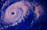
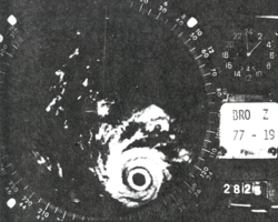
, though building high pressures to the north of the hurricane turned Anita to the west-southwest. The hurricane developed a well-defined eye
, and Hurricane Anita began to rapidly intensify
late on September 1 after attaining major hurricane
status. During a two-day period up to its peak intensity, Anita deepened at a rate of 2 mbar
per hour, and on September 2 the hurricane reached peak winds of 175 mph (280 km/h) while located just offshore northeastern Mexico
, making Anita a Category 5 on the Saffir-Simpson Hurricane Scale
.
Hurricane Anita maintained its strength as it approached land, and at 1100 UTC on September 2 it made landfall
on Soto la Marina
, Tamaulipas
, about 145 miles (235 km) south of Brownsville, Texas
or 80 miles (130 km) north of Tampico
, Mexico. Moving ashore with a pressure of 926 mbar
, Anita was the third most intense tropical cyclone to strike the nation, and was the most intense hurricane to hit from the Gulf of Mexico. It rapidly weakened over the mountainous terrain of Mexico, and on September 3, about 25 hours after moving ashore, Anita emerged into the eastern Pacific Ocean
as a tropical depression. Reclassified as Tropical Depression Eleven, the system continued to the west, and weakened further after encountering cooler water temperatures. The depression gradually lost its deep convection, and on September 4 it dissipated off of the southern tip of the Baja California Peninsula
.
 Shortly after first developing, one oil company evacuated its oil rigs off of Texas
and Louisiana
by helicopter, with several other companies beginning to evacuate unneeded workers. Ultimately, 7,000 oil workers were removed from offshore oil platforms. The threat of the developing disturbance prompted officials to close a state park in southern Louisiana. The National Hurricane Center
advised small craft along the northern Gulf Coast to remain at port. Initially, Anita was predicted to continue tracking west-northwestward and make landfall near the Texas/Louisiana border. As a result, schools in Cameron Parish, Louisiana
were closed, and on August 30 a hurricane watch
was issued for the southwestern Louisiana and northeastern Texas coastlines. After the track shifted further to the south, the watch was replaced with a hurricane warning between Brownsville
and just south of Corpus Christi, Texas
. An emergency shelter was opened in Brownwood, Texas
, and Army
trucks were prepared to assist in evacuations. An official from the National Weather Service
recommended evacuation for all residents east of Galveston, Texas
living in an area below 5 feet (1.5 m) above sea level; about 20,000 left Cameron, Louisiana
. In all, about 58,000 people evacuated coastal locations in Louisiana and Texas.
Though the National Hurricane Center did not issue hurricane warnings for Mexico, officials warned the Mexican government of the potential danger of the hurricane. Across the northeastern coastline of the country, 35,000 people evacuated prior to the arrival of the hurricane, including all of the residents in the village where the hurricane struck. The Mexican army assisted in evacuations and preparing emergency shelters.
, it dropped light rainfall of over 1 inch (25 mm) in the Miami
area. Later, as a developing tropical depression, the system produced gusty winds and heavy rainfall in southern Louisiana
; one station near Galliano
reported over 3 inches (76 mm) of precipitation. Hurricane Anita produced a storm tide
of 2 feet (0.6 m) above normal in Grand Isle
, which resulted in hundreds of families being asked to leave their homes.
The hurricane produced above-normal tides along the Texas
coastline, which closed several highways including Texas State Highway 87. The northern periphery of Hurricane Anita produced light to moderate rainfall across the southern portion of the state, which peaked at 4.97 inches (126 mm) at Rio Grande City
. Damage in the state was minor; on South Padre Island
damage was limited to a few broken windows.
 Hurricane Anita made landfall in a sparsely populated portion of Mexico
; as a result, few meteorological statistics exist. A station near where the hurricane moved ashore recorded 17.52 inches (445 mm) of precipitation in six hours, which resulted in severe flooding and mudslides. Winds along the eastern Mexico coastline were estimated at over 100 mph (160 km/h).
The hurricane caused extensive damage to fishing and farming communities in northeastern Mexico. Strong winds destroyed thousands of homes and left about 25,000 people homeless, according to newspaper reports from Mexico City. The winds destroyed the roofs of most buildings near where the hurricane moved ashore, and also caused widespread power outages which disrupted communications. Heavy rainfall destroyed or obstructed roadways across the region, with some flooded avenues in Tampico
and reports of flooded highways near Ciudad Victoria
. Eleven people were killed in floods and mudslides across Tamaulipas
. In all, at least 50,000 people were affected by the hurricane in Mexico.
, the combination of moderate rainfall and high tides into low-lying marshland led to a mosquito outbreak near Galveston
following the storm.
1977 Atlantic hurricane season
The 1977 Atlantic hurricane season officially began on June 1, 1977, and lasted until November 30, 1977. These dates conventionally delimit the period of each year when most tropical cyclones form in the Atlantic basin....
. The first tropical cyclone
Tropical cyclone
A tropical cyclone is a storm system characterized by a large low-pressure center and numerous thunderstorms that produce strong winds and heavy rain. Tropical cyclones strengthen when water evaporated from the ocean is released as the saturated air rises, resulting in condensation of water vapor...
of the season, Anita developed from a tropical wave
Tropical wave
Tropical waves, easterly waves, or tropical easterly waves, also known as African easterly waves in the Atlantic region, are a type of atmospheric trough, an elongated area of relatively low air pressure, oriented north to south, which move from east to west across the tropics causing areas of...
on August 29 in the north-central Gulf of Mexico
Gulf of Mexico
The Gulf of Mexico is a partially landlocked ocean basin largely surrounded by the North American continent and the island of Cuba. It is bounded on the northeast, north and northwest by the Gulf Coast of the United States, on the southwest and south by Mexico, and on the southeast by Cuba. In...
. It tracked westward into an area with conditions favorable for further development, and quickly intensified into a hurricane by late on August 30. Initially, Anita was forecast to strike Texas
Texas
Texas is the second largest U.S. state by both area and population, and the largest state by area in the contiguous United States.The name, based on the Caddo word "Tejas" meaning "friends" or "allies", was applied by the Spanish to the Caddo themselves and to the region of their settlement in...
, though a building ridge
Ridge (meteorology)
A ridge is an elongated region of relatively high atmospheric pressure, the opposite of a trough....
turned it to the west-southwest. The hurricane rapidly strengthened to attain peak winds of 175 mph (280 km/h), and on September 2 Anita made landfall
Landfall (meteorology)
Landfall is the event of a tropical cyclone or a waterspout coming onto land after being over water. When a waterspout makes landfall it is reclassified as a tornado, which can then cause damage inland...
in eastern Tamaulipas
Tamaulipas
Tamaulipas officially Estado Libre y Soberano de Tamaulipas is one of the 31 states which, with the Federal District, comprise the 32 Federal Entities of Mexico. It is divided in 43 municipalities and its capital city is Ciudad Victoria. The capital city was named after Guadalupe Victoria, the...
as a Category 5 hurricane. It quickly weakened as it crossed Mexico
Mexico
The United Mexican States , commonly known as Mexico , is a federal constitutional republic in North America. It is bordered on the north by the United States; on the south and west by the Pacific Ocean; on the southeast by Guatemala, Belize, and the Caribbean Sea; and on the east by the Gulf of...
, and after briefly redeveloping into a tropical depression in the eastern Pacific Ocean
Pacific Ocean
The Pacific Ocean is the largest of the Earth's oceanic divisions. It extends from the Arctic in the north to the Southern Ocean in the south, bounded by Asia and Australia in the west, and the Americas in the east.At 165.2 million square kilometres in area, this largest division of the World...
, Anita dissipated on September 4 to the south of the Baja California Peninsula
Baja California Peninsula
The Baja California peninsula , is a peninsula in northwestern Mexico. Its land mass separates the Pacific Ocean from the Gulf of California. The Peninsula extends from Mexicali, Baja California in the north to Cabo San Lucas, Baja California Sur in the south.The total area of the Baja California...
.
The hurricane produced light rainfall and high tides along the Gulf Coast of the United States
Gulf Coast of the United States
The Gulf Coast of the United States, sometimes referred to as the Gulf South, South Coast, or 3rd Coast, comprises the coasts of American states that are on the Gulf of Mexico, which includes Texas, Louisiana, Mississippi, Alabama, and Florida and are known as the Gulf States...
. Some low-level flooding was reported, but damage was slight. In Mexico, the hurricane caused strong winds and moderate rainfall. The winds caused extensive damage to villages in northeastern Mexico, with about 25,000 people left homeless. The rainfall, reaching over 17.52 inches (445 mm), caused flooding and mudslides which killed eleven people in Tamaulipas. Overall damage is unknown.
Storm history
A tropical waveTropical wave
Tropical waves, easterly waves, or tropical easterly waves, also known as African easterly waves in the Atlantic region, are a type of atmospheric trough, an elongated area of relatively low air pressure, oriented north to south, which move from east to west across the tropics causing areas of...
moved off the coast of Africa
Africa
Africa is the world's second largest and second most populous continent, after Asia. At about 30.2 million km² including adjacent islands, it covers 6% of the Earth's total surface area and 20.4% of the total land area...
on August 16. The wave axis tracked steadily westward, and on August 23 convection increased after the wave passed beneath a cold-core upper-level low. By August 27, the wave axis was located over Cuba
Cuba
The Republic of Cuba is an island nation in the Caribbean. The nation of Cuba consists of the main island of Cuba, the Isla de la Juventud, and several archipelagos. Havana is the largest city in Cuba and the country's capital. Santiago de Cuba is the second largest city...
, with the area of convection located between Florida
Florida
Florida is a state in the southeastern United States, located on the nation's Atlantic and Gulf coasts. It is bordered to the west by the Gulf of Mexico, to the north by Alabama and Georgia and to the east by the Atlantic Ocean. With a population of 18,801,310 as measured by the 2010 census, it...
and the Bahamas after tracking northwestward. The disturbance crossed southern Florida, and after entering the Gulf of Mexico
Gulf of Mexico
The Gulf of Mexico is a partially landlocked ocean basin largely surrounded by the North American continent and the island of Cuba. It is bounded on the northeast, north and northwest by the Gulf Coast of the United States, on the southwest and south by Mexico, and on the southeast by Cuba. In...
an anticyclone
Anticyclone
An anticyclone is a weather phenomenon defined by the United States' National Weather Service's glossary as "[a] large-scale circulation of winds around a central region of high atmospheric pressure, clockwise in the Northern Hemisphere, counterclockwise in the Southern Hemisphere"...
provided favorable conditions for further development. It tracked slowly westward at 5 mph (7 km/h), and after developing a surface circulation the system developed into a tropical depression on August 29 while located about 230 miles (370 km) south-southwest of New Orleans, Louisiana
New Orleans, Louisiana
New Orleans is a major United States port and the largest city and metropolitan area in the state of Louisiana. The New Orleans metropolitan area has a population of 1,235,650 as of 2009, the 46th largest in the USA. The New Orleans – Metairie – Bogalusa combined statistical area has a population...
.
With a ridge
Ridge (meteorology)
A ridge is an elongated region of relatively high atmospheric pressure, the opposite of a trough....
of high pressure to its north, the depression tracked westward. Favorable conditions persisted for several days prior to the arrival of the depression, and as such the depression quickly intensified into Tropical Storm Anita. The storm tracked slowly over anomalously warm water temperatures, and throughout its duration it was embedded within warm, moist tropical air; Anita rapidly organized and attained hurricane status late on August 30; this is the latest date for the first hurricane since 1967
1967 Atlantic hurricane season
The 1967 Atlantic hurricane season was the first year in which the National Hurricane Center was in operation. The season began on June 1, which was the date when the NHC activated radar stations across the Caribbean and Gulf of Mexico...
. Initially it threatened to strike Texas
Texas
Texas is the second largest U.S. state by both area and population, and the largest state by area in the contiguous United States.The name, based on the Caddo word "Tejas" meaning "friends" or "allies", was applied by the Spanish to the Caddo themselves and to the region of their settlement in...
, though building high pressures to the north of the hurricane turned Anita to the west-southwest. The hurricane developed a well-defined eye
Eye (cyclone)
The eye is a region of mostly calm weather found at the center of strong tropical cyclones. The eye of a storm is a roughly circular area and typically 30–65 km in diameter. It is surrounded by the eyewall, a ring of towering thunderstorms where the second most severe weather of a cyclone...
, and Hurricane Anita began to rapidly intensify
Rapid deepening
Rapid deepening, also known as rapid intensification, is a meteorological condition that occurs when the minimum sea-level atmospheric pressure of a tropical cyclone decreases drastically in a short period of time. The National Weather Service describes rapid deepening as a decrease of...
late on September 1 after attaining major hurricane
Tropical cyclone scales
Tropical systems are officially ranked on one of several tropical cyclone scales according to their maximum sustained winds and in what oceanic basin they are located...
status. During a two-day period up to its peak intensity, Anita deepened at a rate of 2 mbar
Bar (unit)
The bar is a unit of pressure equal to 100 kilopascals, and roughly equal to the atmospheric pressure on Earth at sea level. Other units derived from the bar are the megabar , kilobar , decibar , centibar , and millibar...
per hour, and on September 2 the hurricane reached peak winds of 175 mph (280 km/h) while located just offshore northeastern Mexico
Mexico
The United Mexican States , commonly known as Mexico , is a federal constitutional republic in North America. It is bordered on the north by the United States; on the south and west by the Pacific Ocean; on the southeast by Guatemala, Belize, and the Caribbean Sea; and on the east by the Gulf of...
, making Anita a Category 5 on the Saffir-Simpson Hurricane Scale
Saffir-Simpson Hurricane Scale
The Saffir–Simpson Hurricane Scale , or the Saffir–Simpson Hurricane Wind Scale , classifies hurricanes — Western Hemisphere tropical cyclones that exceed the intensities of tropical depressions and tropical storms — into five categories distinguished by the intensities of their sustained winds...
.
Hurricane Anita maintained its strength as it approached land, and at 1100 UTC on September 2 it made landfall
Landfall (meteorology)
Landfall is the event of a tropical cyclone or a waterspout coming onto land after being over water. When a waterspout makes landfall it is reclassified as a tornado, which can then cause damage inland...
on Soto la Marina
Soto la Marina, Tamaulipas
Soto la Marina is a town in Soto la Marina Municipality located in the Mexican state of Tamaulipas. It was directly hit by Hurricane Alex in 2010.-External links:* Official website...
, Tamaulipas
Tamaulipas
Tamaulipas officially Estado Libre y Soberano de Tamaulipas is one of the 31 states which, with the Federal District, comprise the 32 Federal Entities of Mexico. It is divided in 43 municipalities and its capital city is Ciudad Victoria. The capital city was named after Guadalupe Victoria, the...
, about 145 miles (235 km) south of Brownsville, Texas
Brownsville, Texas
Brownsville is a city in the southernmost tip of the state of Texas, in the United States. It is located on the northern bank of the Rio Grande, directly north and across the border from Matamoros, Tamaulipas, Mexico. Brownsville is the 16th largest city in the state of Texas with a population of...
or 80 miles (130 km) north of Tampico
Tampico
Tampico is a city and port in the state of Tamaulipas, in the country of Mexico. It is located in the southeastern part of the state, directly north across the border from Veracruz. Tampico is the third largest city in Tamaulipas, and counts with a population of 309,003. The Metropolitan area of...
, Mexico. Moving ashore with a pressure of 926 mbar
Bar (unit)
The bar is a unit of pressure equal to 100 kilopascals, and roughly equal to the atmospheric pressure on Earth at sea level. Other units derived from the bar are the megabar , kilobar , decibar , centibar , and millibar...
, Anita was the third most intense tropical cyclone to strike the nation, and was the most intense hurricane to hit from the Gulf of Mexico. It rapidly weakened over the mountainous terrain of Mexico, and on September 3, about 25 hours after moving ashore, Anita emerged into the eastern Pacific Ocean
Pacific Ocean
The Pacific Ocean is the largest of the Earth's oceanic divisions. It extends from the Arctic in the north to the Southern Ocean in the south, bounded by Asia and Australia in the west, and the Americas in the east.At 165.2 million square kilometres in area, this largest division of the World...
as a tropical depression. Reclassified as Tropical Depression Eleven, the system continued to the west, and weakened further after encountering cooler water temperatures. The depression gradually lost its deep convection, and on September 4 it dissipated off of the southern tip of the Baja California Peninsula
Baja California Peninsula
The Baja California peninsula , is a peninsula in northwestern Mexico. Its land mass separates the Pacific Ocean from the Gulf of California. The Peninsula extends from Mexicali, Baja California in the north to Cabo San Lucas, Baja California Sur in the south.The total area of the Baja California...
.
Preparations
Texas
Texas is the second largest U.S. state by both area and population, and the largest state by area in the contiguous United States.The name, based on the Caddo word "Tejas" meaning "friends" or "allies", was applied by the Spanish to the Caddo themselves and to the region of their settlement in...
and Louisiana
Louisiana
Louisiana is a state located in the southern region of the United States of America. Its capital is Baton Rouge and largest city is New Orleans. Louisiana is the only state in the U.S. with political subdivisions termed parishes, which are local governments equivalent to counties...
by helicopter, with several other companies beginning to evacuate unneeded workers. Ultimately, 7,000 oil workers were removed from offshore oil platforms. The threat of the developing disturbance prompted officials to close a state park in southern Louisiana. The National Hurricane Center
National Hurricane Center
The National Hurricane Center , located at Florida International University in Miami, Florida, is the division of the National Weather Service responsible for tracking and predicting weather systems within the tropics between the Prime Meridian and the 140th meridian west poleward to the 30th...
advised small craft along the northern Gulf Coast to remain at port. Initially, Anita was predicted to continue tracking west-northwestward and make landfall near the Texas/Louisiana border. As a result, schools in Cameron Parish, Louisiana
Cameron Parish, Louisiana
Cameron Parish is the parish with the most land area in the U.S. state of Louisiana. The parish seat is Cameron and as of 2010, the population was 6,839...
were closed, and on August 30 a hurricane watch
Tropical cyclone warnings and watches
Warnings and watches are two levels of alert issued by national weather forecasting bodies to coastal areas threatened by the imminent approach of a tropical cyclone of tropical storm or hurricane intensity. They are notices to the local population and civil authorities to make appropriate...
was issued for the southwestern Louisiana and northeastern Texas coastlines. After the track shifted further to the south, the watch was replaced with a hurricane warning between Brownsville
Brownsville, Texas
Brownsville is a city in the southernmost tip of the state of Texas, in the United States. It is located on the northern bank of the Rio Grande, directly north and across the border from Matamoros, Tamaulipas, Mexico. Brownsville is the 16th largest city in the state of Texas with a population of...
and just south of Corpus Christi, Texas
Corpus Christi, Texas
Corpus Christi is a coastal city in the South Texas region of the U.S. state of Texas. The county seat of Nueces County, it also extends into Aransas, Kleberg, and San Patricio counties. The MSA population in 2008 was 416,376. The population was 305,215 at the 2010 census making it the...
. An emergency shelter was opened in Brownwood, Texas
Brownwood, Texas
Brownwood is a city in and the county seat of Brown County, Texas, United States. The population was 18,813 at the 2000 census.-History:The original site of the Brown County seat of Brownwood was on the east of Pecan Bayou. A dispute arose over land and water rights, and the settlers were forced...
, and Army
United States Army
The United States Army is the main branch of the United States Armed Forces responsible for land-based military operations. It is the largest and oldest established branch of the U.S. military, and is one of seven U.S. uniformed services...
trucks were prepared to assist in evacuations. An official from the National Weather Service
National Weather Service
The National Weather Service , once known as the Weather Bureau, is one of the six scientific agencies that make up the National Oceanic and Atmospheric Administration of the United States government...
recommended evacuation for all residents east of Galveston, Texas
Galveston, Texas
Galveston is a coastal city located on Galveston Island in the U.S. state of Texas. , the city had a total population of 47,743 within an area of...
living in an area below 5 feet (1.5 m) above sea level; about 20,000 left Cameron, Louisiana
Cameron, Louisiana
Cameron is a census-designated place in and the parish seat of Cameron Parish, Louisiana, United States. The population was 1,965 at the 2000 census. It is part of the Lake Charles Metropolitan Statistical Area...
. In all, about 58,000 people evacuated coastal locations in Louisiana and Texas.
Though the National Hurricane Center did not issue hurricane warnings for Mexico, officials warned the Mexican government of the potential danger of the hurricane. Across the northeastern coastline of the country, 35,000 people evacuated prior to the arrival of the hurricane, including all of the residents in the village where the hurricane struck. The Mexican army assisted in evacuations and preparing emergency shelters.
United States
As the precursor tropical disturbance crossed southern FloridaFlorida
Florida is a state in the southeastern United States, located on the nation's Atlantic and Gulf coasts. It is bordered to the west by the Gulf of Mexico, to the north by Alabama and Georgia and to the east by the Atlantic Ocean. With a population of 18,801,310 as measured by the 2010 census, it...
, it dropped light rainfall of over 1 inch (25 mm) in the Miami
Miami, Florida
Miami is a city located on the Atlantic coast in southeastern Florida and the county seat of Miami-Dade County, the most populous county in Florida and the eighth-most populous county in the United States with a population of 2,500,625...
area. Later, as a developing tropical depression, the system produced gusty winds and heavy rainfall in southern Louisiana
Louisiana
Louisiana is a state located in the southern region of the United States of America. Its capital is Baton Rouge and largest city is New Orleans. Louisiana is the only state in the U.S. with political subdivisions termed parishes, which are local governments equivalent to counties...
; one station near Galliano
Galliano, Louisiana
Galliano is a census-designated place on the Bayou Lafourche in Lafourche Parish, Louisiana, in the United States. As of the 2000 census, the CDP population was 7,356...
reported over 3 inches (76 mm) of precipitation. Hurricane Anita produced a storm tide
Storm tide
A storm tide is a tide with a high flood period caused by a storm. Storm tides can be a severe danger to the coast and the people living along the coast. The water level can rise to more than 5 meters above the normal tide....
of 2 feet (0.6 m) above normal in Grand Isle
Grand Isle, Louisiana
Grand Isle is a town in Jefferson Parish, Louisiana, located on a barrier island of the same name in the Gulf of Mexico. The island is at the mouth of Barataria Bay where it meets the gulf. As of the 2000 census, the town population was 1,541; during summers, the population sometimes increases to...
, which resulted in hundreds of families being asked to leave their homes.
The hurricane produced above-normal tides along the Texas
Texas
Texas is the second largest U.S. state by both area and population, and the largest state by area in the contiguous United States.The name, based on the Caddo word "Tejas" meaning "friends" or "allies", was applied by the Spanish to the Caddo themselves and to the region of their settlement in...
coastline, which closed several highways including Texas State Highway 87. The northern periphery of Hurricane Anita produced light to moderate rainfall across the southern portion of the state, which peaked at 4.97 inches (126 mm) at Rio Grande City
Rio Grande City, Texas
Rio Grande City is a city in and the county seat of Starr County, Texas, United States. The population was 13,834 at the 2010 census. The city is 41 miles west of McAllen. It is the hometown of former Commander of U.S. Forces in Iraq, General Ricardo Sanchez. The city also holds the March record...
. Damage in the state was minor; on South Padre Island
South Padre Island, Texas
South Padre Island is a town in Cameron County, Texas, United States. It is part of the Brownsville–Harlingen Metropolitan Statistical Area. It may be included as part of the Brownsville–Harlingen–Raymondville and the Matamoros–Brownsville metropolitan areas. The population was 2,816 at the...
damage was limited to a few broken windows.
Mexico
Mexico
The United Mexican States , commonly known as Mexico , is a federal constitutional republic in North America. It is bordered on the north by the United States; on the south and west by the Pacific Ocean; on the southeast by Guatemala, Belize, and the Caribbean Sea; and on the east by the Gulf of...
; as a result, few meteorological statistics exist. A station near where the hurricane moved ashore recorded 17.52 inches (445 mm) of precipitation in six hours, which resulted in severe flooding and mudslides. Winds along the eastern Mexico coastline were estimated at over 100 mph (160 km/h).
The hurricane caused extensive damage to fishing and farming communities in northeastern Mexico. Strong winds destroyed thousands of homes and left about 25,000 people homeless, according to newspaper reports from Mexico City. The winds destroyed the roofs of most buildings near where the hurricane moved ashore, and also caused widespread power outages which disrupted communications. Heavy rainfall destroyed or obstructed roadways across the region, with some flooded avenues in Tampico
Tampico
Tampico is a city and port in the state of Tamaulipas, in the country of Mexico. It is located in the southeastern part of the state, directly north across the border from Veracruz. Tampico is the third largest city in Tamaulipas, and counts with a population of 309,003. The Metropolitan area of...
and reports of flooded highways near Ciudad Victoria
Ciudad Victoria
Ciudad Victoria , is the capital city of the Mexican state ofTamaulipas. It is located in the western-central region of the state. Ciudad Victoria is also the municipal seat of the surrounding Victoria Municipality, which covers an area of 1,638 km²...
. Eleven people were killed in floods and mudslides across Tamaulipas
Tamaulipas
Tamaulipas officially Estado Libre y Soberano de Tamaulipas is one of the 31 states which, with the Federal District, comprise the 32 Federal Entities of Mexico. It is divided in 43 municipalities and its capital city is Ciudad Victoria. The capital city was named after Guadalupe Victoria, the...
. In all, at least 50,000 people were affected by the hurricane in Mexico.
Aftermath
The name Anita was retired following this storm, and will never be used for an Atlantic hurricane again. Due to a naming change in 1979, it was not replaced by any particular name. Shortly after the hurricane made landfall, the government of Mexico sent two trucks of food to the areas of greatest impact. Additionally, officials permitted full use of the Mexican railway system to facilitate the distribution of aid. Three municipalities were also declared disaster areas following the storm. In TexasTexas
Texas is the second largest U.S. state by both area and population, and the largest state by area in the contiguous United States.The name, based on the Caddo word "Tejas" meaning "friends" or "allies", was applied by the Spanish to the Caddo themselves and to the region of their settlement in...
, the combination of moderate rainfall and high tides into low-lying marshland led to a mosquito outbreak near Galveston
Galveston, Texas
Galveston is a coastal city located on Galveston Island in the U.S. state of Texas. , the city had a total population of 47,743 within an area of...
following the storm.
See also
- List of Category 5 Atlantic hurricanes
- List of Atlantic hurricanes