
.gif)
Hurricane Kate (1985)
Encyclopedia
Hurricane Kate was the sixth hurricane to hit the United States during the 1985 Atlantic hurricane season
, tying a record. Forming late in the season, it killed 15 people and caused $530 million (2005 USD
) in damage on its long path through Cuba
, Florida
, and Georgia
between November 18 and November 22, 1985. Kate is the latest-forming major hurricane on record in the Atlantic, and is the latest hurricane to strike the United States.
located across the southeastern United States for much of the autumn of 1985, and concurrently a major trough
persisted across the western portion of the country. As a result, November weather conditions across the Gulf of Mexico
and western Atlantic Ocean were more typical of the pattern in late September, such as sea surface temperature
s of 27 °C (80.6 °F). On November 13, a weak tropical wave
, or elongated area of low pressure
, began interacting with a trough to the northeast of the Lesser Antilles
. It gradually organized, and on November 15 a Hurricane Hunters
flight into the area indicated the development
of a tropical cyclone
; as gale force winds were already present, the system was upgraded directly to Tropical Storm Kate, about 240 miles (385 km) northeast of San Juan, Puerto Rico
.
An anticyclone developed over the Florida Keys
, providing Kate with the opportunity to strengthen. After drifting northwestward, Kate accelerated to the west over the southern Bahamas, becoming a hurricane on November 16 and a 110 mph (175 km/h) hurricane on November 19. It subsequently hit northern Cuba
, where 200,000 people in Havana
were evacuated. With the eyewall over land, Kate weakened to a 90 mph (155 km/h) hurricane before emerging into the Gulf of Mexico later that day.
Hurricane Kate maintained its organization while crossing northern Cuba, and quickly re-strengthened in the Gulf of Mexico. It rapidly intensified on November 20 to a 120 mph (195 km/h) major hurricane. An approaching frontal trough brought Kate to the northeast, where slightly cooler waters over the northern Gulf of Mexico weakened the hurricane. It hit Mexico Beach, Florida
late on the November 21 as a 95 mph hurricane, and quickly weakened over land. After crossing Georgia, Kate approached very cold waters and increasing upper-level shear, causing the hurricane to become extratropical on November 23 while southeast of North Carolina
.
in 1932, Hurricane Greta
in 1956, Hurricane Lenny
in 1999, Hurricane Michelle
in 2001, and Hurricane Paloma in 2008. Kate was also the latest-season major hurricane, having become a major hurricane on November 20. Kate was also one of the latest landfalls, as well as the strongest U.S. landfall in November, hitting with 105 mph winds.
's northern coastline. Downed trees and power lines were common along the coast and 10 people were killed in Cuba from the hurricane. Kate's winds and flooding resulted in significant crop damage, destroying significant amounts of the sugarcane and banana harvests. Over 3,600 square miles (9,300 square kilometers) of sugar cane were destroyed, while 155,000 short ton
s (136 million kilograms) of sugar cane were lost. http://wwwnotes.reliefweb.int/w/RWB.NSF/480fa8736b88bbc3c12564f6004c8ad5/53213dbb2dd36df4c1256570004c8424?OpenDocument In all, damage totaled to $400 million (1985 USD, $710 million 2005 USD).
Following the storm's passage, the crop losses prompted the Cuban government to request for international aid. The affected population needed food for 60 days, over 10,000 metric tons (10 million kg) of flour, and over 1,200 tons of cooking oil. Countries around the world contributed over $17 million in either money or food.
 Over 100,000 people were evacuated from the Florida Panhandle
prior to Kate's arrival. Just 2 months after Hurricane Elena
caused significant damage to the oyster industry, Hurricane Kate destroyed much of what little was left in Apalachicola Bay
. Lack of production caused many oystermen to lose their jobs, and many fishermen before and after the storm were suffering due to lack of fish. In addition, severely eroded coastlines lost even more beach from a 10 foot (3 m) storm surge and strong waves.
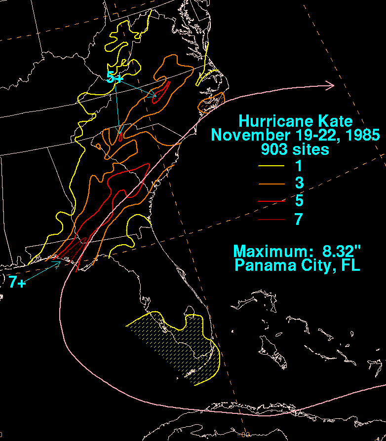 Rainfall amounts along the coast ranged from a trace to a maximum of 5.8 inches (150 mm) in Panama City, Florida
. Along the coastline, there was extensive road damage, with potholes up to 4 feet (1.2 m) in length along U.S. Route 98
. http://www.tallytown.com/redcross/library/kate-td-1985-11-24-01.pdf Kate's strong winds and rain damaged at least 600 houses and water craft, amounting to $300 million (1985 USD
) in damage. A total of five people were killed in Florida
.
Hurricane Kate passed just west of Tallahassee
, but because it was becoming extratropical, damage was limited to downed trees and minor structural damage. http://www.aoml.noaa.gov/general/lib/lib1/nhclib/mwreviews/1985.pdf Flooding and power outages across 90% of the city forced a curfew, taking up to two weeks to clean up. A positive aspect of the storm was the economic boost from coastal evacuees. Restaurants, hotels, and stores were full from those taking refuge from the storm.
of Atlantic tropical cyclones.
1985 Atlantic hurricane season
The 1985 Atlantic hurricane season had the most U.S. landfalling tropical cyclones since 1916. The season officially began on June 1, 1985, and lasted until November 30, 1985...
, tying a record. Forming late in the season, it killed 15 people and caused $530 million (2005 USD
United States dollar
The United States dollar , also referred to as the American dollar, is the official currency of the United States of America. It is divided into 100 smaller units called cents or pennies....
) in damage on its long path through Cuba
Cuba
The Republic of Cuba is an island nation in the Caribbean. The nation of Cuba consists of the main island of Cuba, the Isla de la Juventud, and several archipelagos. Havana is the largest city in Cuba and the country's capital. Santiago de Cuba is the second largest city...
, Florida
Florida
Florida is a state in the southeastern United States, located on the nation's Atlantic and Gulf coasts. It is bordered to the west by the Gulf of Mexico, to the north by Alabama and Georgia and to the east by the Atlantic Ocean. With a population of 18,801,310 as measured by the 2010 census, it...
, and Georgia
Georgia (U.S. state)
Georgia is a state located in the southeastern United States. It was established in 1732, the last of the original Thirteen Colonies. The state is named after King George II of Great Britain. Georgia was the fourth state to ratify the United States Constitution, on January 2, 1788...
between November 18 and November 22, 1985. Kate is the latest-forming major hurricane on record in the Atlantic, and is the latest hurricane to strike the United States.
Meteorological history
Before the formation of Hurricane Kate, there was a ridgeRidge (meteorology)
A ridge is an elongated region of relatively high atmospheric pressure, the opposite of a trough....
located across the southeastern United States for much of the autumn of 1985, and concurrently a major trough
Trough (meteorology)
A trough is an elongated region of relatively low atmospheric pressure, often associated with fronts.Unlike fronts, there is not a universal symbol for a trough on a weather chart. The weather charts in some countries or regions mark troughs by a line. In the United States, a trough may be marked...
persisted across the western portion of the country. As a result, November weather conditions across the Gulf of Mexico
Gulf of Mexico
The Gulf of Mexico is a partially landlocked ocean basin largely surrounded by the North American continent and the island of Cuba. It is bounded on the northeast, north and northwest by the Gulf Coast of the United States, on the southwest and south by Mexico, and on the southeast by Cuba. In...
and western Atlantic Ocean were more typical of the pattern in late September, such as sea surface temperature
Sea surface temperature
Sea surface temperature is the water temperature close to the oceans surface. The exact meaning of surface varies according to the measurement method used, but it is between and below the sea surface. Air masses in the Earth's atmosphere are highly modified by sea surface temperatures within a...
s of 27 °C (80.6 °F). On November 13, a weak tropical wave
Tropical wave
Tropical waves, easterly waves, or tropical easterly waves, also known as African easterly waves in the Atlantic region, are a type of atmospheric trough, an elongated area of relatively low air pressure, oriented north to south, which move from east to west across the tropics causing areas of...
, or elongated area of low pressure
Low pressure area
A low-pressure area, or "low", is a region where the atmospheric pressure at sea level is below that of surrounding locations. Low-pressure systems form under areas of wind divergence which occur in upper levels of the troposphere. The formation process of a low-pressure area is known as...
, began interacting with a trough to the northeast of the Lesser Antilles
Lesser Antilles
The Lesser Antilles are a long, partly volcanic island arc in the Western Hemisphere. Most of its islands form the eastern boundary of the Caribbean Sea with the Atlantic Ocean, with the remainder located in the southern Caribbean just north of South America...
. It gradually organized, and on November 15 a Hurricane Hunters
Hurricane Hunters
The Hurricane Hunters are aircraft that fly into tropical cyclones in the North Atlantic Ocean and Northeastern Pacific Ocean for the specific purpose of directly measuring weather data in and around those storms. In the United States, the Air Force, Navy, and NOAA units have all participated in...
flight into the area indicated the development
Tropical cyclogenesis
Tropical cyclogenesis is the term that describes the development and strengthening of a tropical cyclone in the atmosphere. The mechanisms through which tropical cyclogenesis occurs are distinctly different from those through which mid-latitude cyclogenesis occurs...
of a tropical cyclone
Tropical cyclone
A tropical cyclone is a storm system characterized by a large low-pressure center and numerous thunderstorms that produce strong winds and heavy rain. Tropical cyclones strengthen when water evaporated from the ocean is released as the saturated air rises, resulting in condensation of water vapor...
; as gale force winds were already present, the system was upgraded directly to Tropical Storm Kate, about 240 miles (385 km) northeast of San Juan, Puerto Rico
San Juan, Puerto Rico
San Juan , officially Municipio de la Ciudad Capital San Juan Bautista , is the capital and most populous municipality in Puerto Rico, an unincorporated territory of the United States. As of the 2010 census, it had a population of 395,326 making it the 46th-largest city under the jurisdiction of...
.
An anticyclone developed over the Florida Keys
Florida Keys
The Florida Keys are a coral archipelago in southeast United States. They begin at the southeastern tip of the Florida peninsula, about south of Miami, and extend in a gentle arc south-southwest and then westward to Key West, the westernmost of the inhabited islands, and on to the uninhabited Dry...
, providing Kate with the opportunity to strengthen. After drifting northwestward, Kate accelerated to the west over the southern Bahamas, becoming a hurricane on November 16 and a 110 mph (175 km/h) hurricane on November 19. It subsequently hit northern Cuba
Cuba
The Republic of Cuba is an island nation in the Caribbean. The nation of Cuba consists of the main island of Cuba, the Isla de la Juventud, and several archipelagos. Havana is the largest city in Cuba and the country's capital. Santiago de Cuba is the second largest city...
, where 200,000 people in Havana
Havana
Havana is the capital city, province, major port, and leading commercial centre of Cuba. The city proper has a population of 2.1 million inhabitants, and it spans a total of — making it the largest city in the Caribbean region, and the most populous...
were evacuated. With the eyewall over land, Kate weakened to a 90 mph (155 km/h) hurricane before emerging into the Gulf of Mexico later that day.
Hurricane Kate maintained its organization while crossing northern Cuba, and quickly re-strengthened in the Gulf of Mexico. It rapidly intensified on November 20 to a 120 mph (195 km/h) major hurricane. An approaching frontal trough brought Kate to the northeast, where slightly cooler waters over the northern Gulf of Mexico weakened the hurricane. It hit Mexico Beach, Florida
Mexico Beach, Florida
Mexico Beach is a city in Bay County, Florida, United States. The population was 1,072 at the 2010 census. . It is part of the Panama City–Lynn Haven–Panama City Beach Metropolitan Statistical Area.-Geography:Mexico Beach is located at ....
late on the November 21 as a 95 mph hurricane, and quickly weakened over land. After crossing Georgia, Kate approached very cold waters and increasing upper-level shear, causing the hurricane to become extratropical on November 23 while southeast of North Carolina
North Carolina
North Carolina is a state located in the southeastern United States. The state borders South Carolina and Georgia to the south, Tennessee to the west and Virginia to the north. North Carolina contains 100 counties. Its capital is Raleigh, and its largest city is Charlotte...
.
Late formation
Kate was unusual, because it became a major hurricane in November, one of only seven storms to do so. Other storms that became major hurricanes in November include The Jamaica Hurricane of 1912, The Great Cuba Hurricane1932 Cuba Hurricane
The 1932 Cuba hurricane was a powerful and deadly late-season hurricane during the 1932 Atlantic hurricane season. It was the tenth tropical storm, fifth hurricane and fourth major hurricane of the 1932 season...
in 1932, Hurricane Greta
Hurricane Greta (1956)
Hurricane Greta was the largest Atlantic hurricane ever recorded, with tropical storm-force winds spanning an area 1,200 miles wide. Originating from a tropical depression near Jamaica on October 30, the system initially featured non-tropical characteristics as it tracked northward...
in 1956, Hurricane Lenny
Hurricane Lenny
Hurricane Lenny was the strongest November Atlantic hurricane on record. It was the twelfth tropical storm, eighth hurricane, and record-breaking fifth Category 4 hurricane in the 1999 Atlantic hurricane season. Lenny formed on November 13 in the western Caribbean Sea, and maintained an...
in 1999, Hurricane Michelle
Hurricane Michelle
Hurricane Michelle was the thirteenth named storm and the strongest tropical cyclone of the 2001 Atlantic hurricane season. Michelle developed from a tropical wave that moved across the Atlantic, and formed into Tropical Depression Fifteen on the October 29. The depression slowly intensified as...
in 2001, and Hurricane Paloma in 2008. Kate was also the latest-season major hurricane, having become a major hurricane on November 20. Kate was also one of the latest landfalls, as well as the strongest U.S. landfall in November, hitting with 105 mph winds.
Cuba
In preparation for the hurricane's arrival, 300,000 people evacuated low-lying coastal areas. Heavy flooding and 125 mph (200 km/h) gusts destroyed 4,382 houses and damaged 88,207 on CubaCuba
The Republic of Cuba is an island nation in the Caribbean. The nation of Cuba consists of the main island of Cuba, the Isla de la Juventud, and several archipelagos. Havana is the largest city in Cuba and the country's capital. Santiago de Cuba is the second largest city...
's northern coastline. Downed trees and power lines were common along the coast and 10 people were killed in Cuba from the hurricane. Kate's winds and flooding resulted in significant crop damage, destroying significant amounts of the sugarcane and banana harvests. Over 3,600 square miles (9,300 square kilometers) of sugar cane were destroyed, while 155,000 short ton
Short ton
The short ton is a unit of mass equal to . In the United States it is often called simply ton without distinguishing it from the metric ton or the long ton ; rather, the other two are specifically noted. There are, however, some U.S...
s (136 million kilograms) of sugar cane were lost. http://wwwnotes.reliefweb.int/w/RWB.NSF/480fa8736b88bbc3c12564f6004c8ad5/53213dbb2dd36df4c1256570004c8424?OpenDocument In all, damage totaled to $400 million (1985 USD, $710 million 2005 USD).
Following the storm's passage, the crop losses prompted the Cuban government to request for international aid. The affected population needed food for 60 days, over 10,000 metric tons (10 million kg) of flour, and over 1,200 tons of cooking oil. Countries around the world contributed over $17 million in either money or food.
Northern Gulf Coast
Florida Panhandle
The Florida Panhandle, an informal, unofficial term for the northwestern part of Florida, is a strip of land roughly 200 miles long and 50 to 100 miles wide , lying between Alabama on the north and the west, Georgia also on the north, and the Gulf of Mexico to the south. Its eastern boundary is...
prior to Kate's arrival. Just 2 months after Hurricane Elena
Hurricane Elena
Hurricane Elena was a category 3 major hurricane that produced heavy damage along the Gulf Coast of the United States in August and September of the 1985 Atlantic hurricane season. The fifth tropical storm, fourth hurricane, and first major hurricane of the season, Elena developed near Cuba from a...
caused significant damage to the oyster industry, Hurricane Kate destroyed much of what little was left in Apalachicola Bay
Apalachicola Bay
Apalachicola Bay is an estuary and lagoon located on Florida's northwest coast renowned for its oysters. The Apalachicola Bay system also includes St. Georges Sound, St. Vincent Sound and East Bay, covering an area of about . Four islands St. Vincent Island to the west, Cape St. George Island and St...
. Lack of production caused many oystermen to lose their jobs, and many fishermen before and after the storm were suffering due to lack of fish. In addition, severely eroded coastlines lost even more beach from a 10 foot (3 m) storm surge and strong waves.
Panama City, Florida
-Personal income:The median income for a household in the city was $31,572, and the median income for a family was $40,890. Males had a median income of $30,401 versus $21,431 for females. The per capita income for the city was $17,830...
. Along the coastline, there was extensive road damage, with potholes up to 4 feet (1.2 m) in length along U.S. Route 98
U.S. Route 98
U.S. Route 98 is an east–west United States highway that runs from western Mississippi to southern Florida. It was established in 1933 as a route between Pensacola, Florida and Apalachicola, Florida, and has since been extended westward into Mississippi and eastward across the Florida...
. http://www.tallytown.com/redcross/library/kate-td-1985-11-24-01.pdf Kate's strong winds and rain damaged at least 600 houses and water craft, amounting to $300 million (1985 USD
United States dollar
The United States dollar , also referred to as the American dollar, is the official currency of the United States of America. It is divided into 100 smaller units called cents or pennies....
) in damage. A total of five people were killed in Florida
Florida
Florida is a state in the southeastern United States, located on the nation's Atlantic and Gulf coasts. It is bordered to the west by the Gulf of Mexico, to the north by Alabama and Georgia and to the east by the Atlantic Ocean. With a population of 18,801,310 as measured by the 2010 census, it...
.
Hurricane Kate passed just west of Tallahassee
Tallahassee, Florida
Tallahassee is the capital of the U.S. state of Florida. It is the county seat and only incorporated municipality in Leon County, and is the 128th largest city in the United States. Tallahassee became the capital of Florida, then the Florida Territory, in 1824. In 2010, the population recorded by...
, but because it was becoming extratropical, damage was limited to downed trees and minor structural damage. http://www.aoml.noaa.gov/general/lib/lib1/nhclib/mwreviews/1985.pdf Flooding and power outages across 90% of the city forced a curfew, taking up to two weeks to clean up. A positive aspect of the storm was the economic boost from coastal evacuees. Restaurants, hotels, and stores were full from those taking refuge from the storm.
Records
Hurricane Kate was the latest hurricane recorded to strike the United States as a hurricane. This was re-evaluated as the earliest hurricane to come ashore in the U.S. from the 1925 Florida tropical storm, which was originally considered a hurricane but was downgraded in modern reanalysisAtlantic hurricane reanalysis
Atlantic hurricane reanalysis is an ongoing project within the National Oceanic and Atmospheric Administration which seeks to correct and add new information about past Atlantic tropical cyclones...
of Atlantic tropical cyclones.
External links
- Monthly Weather Review
- Hurricane Kate (1985)
- Hurricane Kate Damage
- Hurricane Kate Track (Unisys)
- David Longshore. "Hurricane Kate." Encyclopedia of Hurricanes, Typhoons and Cyclones. David Longshore. New York: Facts on File, 1998, Pg; 208-209.
See also
- List of North Carolina hurricanes (1980–1999)
- List of Florida hurricanes (1975-1999)
- Other storms of the same nameTropical Storm KateThe name Kate has been used for two tropical cyclones in the Atlantic Ocean, eleven tropical cyclones in the western Pacific, and at least two in the Southern Hemisphere.The name is used on the modern six-year lists in the Atlantic:...