
Gale warning
Encyclopedia
A gale warning is a warning issued by weather services in maritime locations about the existence of winds of gale force
or above or the imminent occurrence of gale
s at sea. The purpose of gale warnings is to allow mariners to take precautionary actions to ensure their safety at sea.
 In the United States
, the National Weather Service
issues Gale warnings for marine areas experiencing, or about to experience, winds within the range of 39 to 54 miles per hour or 63 to 69 km-h ( approximately 34 to 47 knots). A High Wind Warning is a similar warning issued by the National Weather Service
if winds are forecast to be 39-57 mph for at least 1 hour; or any gusts to 58-73 mph on land. If the winds are associated with a tropical cyclone, a Tropical Storm Warning will be substituted for the Gale Warning and more severe Storm Warning
. The same flag as a storm warning is used for a Tropical Storm Warning.
In the UK
gale warnings are issued by the Meteorological Office and are broadcast by radio four times a day at fixed times on 198 kHz in the shipping forecast
, part of the broadcast output of BBC Radio 4
. If there is to be a considerable time before the next Shipping Forecast, an extra gale warning is issued and read out between programmes. Warnings are issued for sea areas surrounding the UK for all predictions of winds of Beaufort
Force 8 or above, the forecasts extending as far north as Iceland
and as far south as southern Spain
.
Met Éireann
, the Irish
meteorological office, issue warnings for sea areas around Ireland
, with stretchs of coast defined by the headlands of Ireland (e.g. Fair Head
, Malin Head
, Mizen Head
, Carnsore Point
), and an area forecast for the Irish Sea
.
Though usually associated with deep low pressure centers, winds strong enough to catalyze a gale warning can occur in other conditions as well, including from anticyclone
s, or high-pressure systems, in the continental interior. However the warning is most commonly issued in coastal areas, and is primarily directed at marine rather than land-based interests — and the term High Wind Warning (SAME
code: HWW) is substituted for "gale warning" (and the more severe "storm warning") in non-maritime settings in the United States for winds between 39 and 71 mph. In some cases, a dust storm
can be produced by high winds with little or no warning.
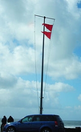
The flags for a gale warning are two red pennants, one placed above the other (display of only one such flag denotes a small craft advisory
).
A similar warning is issued by Environment Canada
's Meteorological Service of Canada
for lakes and oceans within Canada
's juridiction.
Beaufort scale
The Beaufort Scale is an empirical measure that relates wind speed to observed conditions at sea or on land. Its full name is the Beaufort Wind Force Scale.-History:...
or above or the imminent occurrence of gale
Gale
A gale is a very strong wind. There are conflicting definitions of how strong a wind must be to be considered a gale. The U.S. government's National Weather Service defines a gale as 34–47 knots of sustained surface winds. Forecasters typically issue gale warnings when winds of this strength are...
s at sea. The purpose of gale warnings is to allow mariners to take precautionary actions to ensure their safety at sea.
United States
The United States of America is a federal constitutional republic comprising fifty states and a federal district...
, the National Weather Service
National Weather Service
The National Weather Service , once known as the Weather Bureau, is one of the six scientific agencies that make up the National Oceanic and Atmospheric Administration of the United States government...
issues Gale warnings for marine areas experiencing, or about to experience, winds within the range of 39 to 54 miles per hour or 63 to 69 km-h ( approximately 34 to 47 knots). A High Wind Warning is a similar warning issued by the National Weather Service
National Weather Service
The National Weather Service , once known as the Weather Bureau, is one of the six scientific agencies that make up the National Oceanic and Atmospheric Administration of the United States government...
if winds are forecast to be 39-57 mph for at least 1 hour; or any gusts to 58-73 mph on land. If the winds are associated with a tropical cyclone, a Tropical Storm Warning will be substituted for the Gale Warning and more severe Storm Warning
Storm warning
At sea, a storm warning is a warning issued by the National Weather Service of the United States when winds between 48 knots and 63 knots are occurring or predicted to occur soon. The winds must not be associated with a tropical cyclone...
. The same flag as a storm warning is used for a Tropical Storm Warning.
In the UK
United Kingdom
The United Kingdom of Great Britain and Northern IrelandIn the United Kingdom and Dependencies, other languages have been officially recognised as legitimate autochthonous languages under the European Charter for Regional or Minority Languages...
gale warnings are issued by the Meteorological Office and are broadcast by radio four times a day at fixed times on 198 kHz in the shipping forecast
Shipping Forecast
The Shipping Forecast is a four-times-daily BBC Radio broadcast of weather reports and forecasts for the seas around the coasts of the British Isles. It is produced by the Met Office and broadcast by BBC Radio 4 on behalf of the Maritime and Coastguard Agency. The forecasts sent over the Navtex...
, part of the broadcast output of BBC Radio 4
BBC Radio 4
BBC Radio 4 is a British domestic radio station, operated and owned by the BBC, that broadcasts a wide variety of spoken-word programmes, including news, drama, comedy, science and history. It replaced the BBC Home Service in 1967. The station controller is currently Gwyneth Williams, and the...
. If there is to be a considerable time before the next Shipping Forecast, an extra gale warning is issued and read out between programmes. Warnings are issued for sea areas surrounding the UK for all predictions of winds of Beaufort
Beaufort scale
The Beaufort Scale is an empirical measure that relates wind speed to observed conditions at sea or on land. Its full name is the Beaufort Wind Force Scale.-History:...
Force 8 or above, the forecasts extending as far north as Iceland
Iceland
Iceland , described as the Republic of Iceland, is a Nordic and European island country in the North Atlantic Ocean, on the Mid-Atlantic Ridge. Iceland also refers to the main island of the country, which contains almost all the population and almost all the land area. The country has a population...
and as far south as southern Spain
Spain
Spain , officially the Kingdom of Spain languages]] under the European Charter for Regional or Minority Languages. In each of these, Spain's official name is as follows:;;;;;;), is a country and member state of the European Union located in southwestern Europe on the Iberian Peninsula...
.
Met Éireann
Met Éireann
Met Éireann is the national meteorological service in Ireland, part of the Department of the Environment, Heritage and Local Government.-History:...
, the Irish
Republic of Ireland
Ireland , described as the Republic of Ireland , is a sovereign state in Europe occupying approximately five-sixths of the island of the same name. Its capital is Dublin. Ireland, which had a population of 4.58 million in 2011, is a constitutional republic governed as a parliamentary democracy,...
meteorological office, issue warnings for sea areas around Ireland
Ireland
Ireland is an island to the northwest of continental Europe. It is the third-largest island in Europe and the twentieth-largest island on Earth...
, with stretchs of coast defined by the headlands of Ireland (e.g. Fair Head
Fair Head
Fair Head is a rocky headland at the north-eastern corner of Northern Ireland, in County Antrim. It lies 3 miles east of Ballycastle town, and is the closest part of the mainland to Rathlin Island...
, Malin Head
Malin Head
Malin Head , on the Inishowen Peninsula, County Donegal, is usually given as the most northerly headland of the mainland of Ireland . In fact, the most northerly point is actually a headland named Banba's Crown on the Inishowen Peninsula about 2 km to the northeast...
, Mizen Head
Mizen Head
Mizen Head , is located at the extremity of a peninsula in the district of Carbery in County Cork, Ireland. It is one of the extreme points of the island of Ireland and is a major tourist attraction, noted for its dramatic cliff scenery...
, Carnsore Point
Carnsore Point
Carnsore Point is a headland in the very South East corner of County Wexford, Ireland. This headland is Ireland's southern limit point of the Irish Sea....
), and an area forecast for the Irish Sea
Irish Sea
The Irish Sea separates the islands of Ireland and Great Britain. It is connected to the Celtic Sea in the south by St George's Channel, and to the Atlantic Ocean in the north by the North Channel. Anglesey is the largest island within the Irish Sea, followed by the Isle of Man...
.
Though usually associated with deep low pressure centers, winds strong enough to catalyze a gale warning can occur in other conditions as well, including from anticyclone
Anticyclone
An anticyclone is a weather phenomenon defined by the United States' National Weather Service's glossary as "[a] large-scale circulation of winds around a central region of high atmospheric pressure, clockwise in the Northern Hemisphere, counterclockwise in the Southern Hemisphere"...
s, or high-pressure systems, in the continental interior. However the warning is most commonly issued in coastal areas, and is primarily directed at marine rather than land-based interests — and the term High Wind Warning (SAME
Specific Area Message Encoding
Specific Area Message Encoding or SAME is the protocol used to encode the Emergency Alert System and NOAA Weather Radio's SAME Public Warning System in the U.S...
code: HWW) is substituted for "gale warning" (and the more severe "storm warning") in non-maritime settings in the United States for winds between 39 and 71 mph. In some cases, a dust storm
Dust storm
A dust / sand storm is a meteorological phenomenon common in arid and semi-arid regions. Dust storms arise when a gust front or other strong wind blows loose sand and dirt from a dry surface. Particles are transported by saltation and suspension, causing soil to move from one place and deposition...
can be produced by high winds with little or no warning.
The flags for a gale warning are two red pennants, one placed above the other (display of only one such flag denotes a small craft advisory
Small craft advisory
A small craft advisory is a type of warning issued by the National Weather Service in the United States, most frequently in coastal areas. It is issued when winds have reached, or are expected to reach within 12 hours, a speed marginally less than gale force....
).
A similar warning is issued by Environment Canada
Environment Canada
Environment Canada , legally incorporated as the Department of the Environment under the Department of the Environment Act Environment Canada (EC) (French: Environnement Canada), legally incorporated as the Department of the Environment under the Department of the Environment Act Environment...
's Meteorological Service of Canada
Meteorological Service of Canada
The Meteorological Service of Canada , also known as "The Canadian Weather Service", is a division of Environment Canada, which primarily provides public meteorological information and weather forecasts and warnings of severe weather and other environmental hazards...
for lakes and oceans within Canada
Canada
Canada is a North American country consisting of ten provinces and three territories. Located in the northern part of the continent, it extends from the Atlantic Ocean in the east to the Pacific Ocean in the west, and northward into the Arctic Ocean...
's juridiction.
Example of Gale Warning
The following is an example of a Gale Warning issued by the National Weather Service office in Miami, Florida.
399

WHUS72 KMFL 120829

MWWMFL


URGENT - MARINE WEATHER MESSAGE

NATIONAL WEATHER SERVICE MIAMI FL

329 AM EST FRI FEB 12 2010


...GALE FORCE WIND GUSTS TODAY THROUGH TONIGHT...


AMZ610-630-650-651-670-671-GMZ656-657-676-131200-

/O.UPG.KMFL.GL.A.0001.100212T1500Z-100213T0900Z/

/O.NEW.KMFL.GL.W.0001.100212T1800Z-100213T1200Z/

LAKE OKEECHOBEE-BISCAYNE BAY-

COASTAL WATERS FROM JUPITER INLET TO DEERFIELD BEACH, FL OUT

20 NM-

COASTAL WATERS FROM DEERFIELD BEACH TO OCEAN REEF, FL OUT 20 NM-

WATERS FROM JUPITER INLET TO DEERFIELD BEACH, FL EXTENDING FROM

20 NM TO 60 NM-

WATERS FROM DEERFIELD BEACH TO OCEAN REEF, FL EXTENDING FROM

20 NM TO THE TERRITORIAL WATERS OF THE BAHAMAS-

COASTAL WATERS FROM CHOKOLOSKEE TO BONITA BEACH, FL OUT 20 NM-

COASTAL WATERS FROM EAST CAPE SABLE TO CHOKOLOSKEE, FL OUT 20 NM-

GULF WATERS FROM CHOKOLOSKEE TO BONITA BEACH, FL EXTENDING FROM

20 TO 60 NM-

329 AM EST FRI FEB 12 2010


...GALE WARNING IN EFFECT FROM 1 PM THIS AFTERNOON TO 7 AM EST

SATURDAY...


THE NATIONAL WEATHER SERVICE IN MIAMI HAS ISSUED A GALE WARNING...

WHICH IS IN EFFECT FROM 1 PM THIS AFTERNOON TO 7 AM EST SATURDAY.

THE GALE WATCH IS NO LONGER IN EFFECT.


A STRONG LOW PRESSURE SYSTEM WILL PASS NORTH OF THE REGION THIS

EVENING. STRONG SOUTHERLY WINDS ARE EXPECTED TO DEVELOP QUICKLY

TODAY AHEAD OF THE LOW...WITH STRONG WESTERLY WINDS BEHIND THE

ASSOCIATED COLD FRONT PASSING DURING THE EVENING HOURS. SUSTAINED

WINDS OF 25 TO 30 KNOTS ARE POSSIBLE WITH FREQUENT GUSTS TO NEAR

40 KNOTS EVEN OUTSIDE OF THUNDERSTORMS. THESE WINDS WILL LEAD TO

EXTREMELY DANGEROUS MARINE CONDITIONS.


PRECAUTIONARY/PREPAREDNESS ACTIONS...


A GALE WARNING MEANS WINDS OF 34 TO 47 KNOTS ARE IMMINENT OR

OCCURRING. OPERATING A VESSEL IN GALE CONDITIONS REQUIRES

EXPERIENCE AND PROPERLY EQUIPPED VESSELS. IT IS HIGHLY

RECOMMENDED THAT MARINERS WITHOUT THE PROPER EXPERIENCE SEEK SAFE

HARBOR PRIOR TO THE ONSET OF GALE CONDITIONS.


&&


$$
See also
- Small-craft advisory
- Storm warningStorm warningAt sea, a storm warning is a warning issued by the National Weather Service of the United States when winds between 48 knots and 63 knots are occurring or predicted to occur soon. The winds must not be associated with a tropical cyclone...
- Hurricane warning
- Severe weather terminology (United States)Severe weather terminology (United States)This article describes the United States National Weather Service severe weather terminology. The NWS defines precise meanings for nearly all its weather terms. This article describes NWS terminology and related NWS weather scales...