
.gif)
Hurricane Danny (1985)
Encyclopedia
Hurricane Danny was a minimal Category 1 hurricane on the Saffir-Simpson hurricane scale
that made landfall
in the U.S. state
of Louisiana
. The fourth tropical cyclone
and third hurricane of the 1985 Atlantic hurricane season
, Danny originated from a tropical wave
that moved into the western Caribbean
in the middle of August, and struggled to reach tropical storm status until it entered the central Gulf of Mexico
. Organizing rapidly, the system reached hurricane status several hundred miles south of Louisiana, and reached a peak intensity of 80 mph (130 km/h) before making landfall near Lake Charles, Louisiana
.
Danny produced an outbreak
of 39 tornadoes and flash flooding across the United States Gulf Coast and Southeastern United States
causing 100 million dollars (1985 USD
) and three fatalities, two of them directly related to the storm.
moved off the west coast of Africa
on July 30 and continued across the Atlantic
and though the Leeward Islands
with no sign of development. On August 12, data from hurricane hunter flights indicated that a tropical depression formed near the Cayman Islands
. The tropical depression then crossed the tip of Cuba
and entered the Gulf of Mexico
on August 13. In a 24 hour period, the depression rapidly intensified into a tropical storm and then a hurricane and was named Danny by the National Hurricane Center
. Danny continued northwest with a peak wind speed of 80 mph and minimum barometric pressure of 987 millibars before making landfall near Lake Charles, Louisiana
. Danny then quickly weakened into a tropical storm as it moved inland. The center was still identifiable before the storm became extratropical near the East coast of the United States
.
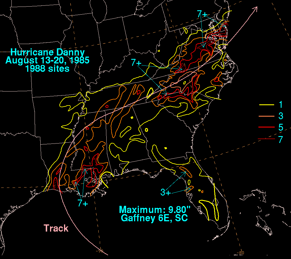 Overall, Danny killed three people and left up to $100 million dollars in damage (1985 USD) in damage. Danny also produced an unusually intense outbreak of tornadoes, with 39 touchdowns occurring over seven states. At the time, this outbreak contained the highest number violent tornadoes spawned by a hurricane, 13; however, since then, Hurricane Ivan
in 2004 surpassed this, producing 18 violent tornadoes. Moderate to heavy rainfall fell to the east of the track while Danny remained tropical. As it was transitioning into a frontal wave across the East, heavy rainfall became focused to the left of its track, overrunning the frontal surface ahead of the storm.
, the storm dropped heavy rainfall with totals of 3 inches reported in New Orleans and Baton Rouge. there was moderate flooding and 275 homes were destroyed or severely damaged. About 792 people were left homeless and sixty six were injured by the storm there were no deaths. The American Red Cross
reported that there was up to $23 million dollars (1985 USD
) in damage. Governor Edwin Edwards
declared a state of emergency for 13 parishes. In Mississippi
, an F2
tornado
spawned by Danny touched down near Hickory
at 1235 UTC. The 72 feet (21.9 m) wide tornado caused no damage. Another tornado, an F0
touched down near Enterprise
causing no damage.
, two of the most damaging tornadoes spawned by Hurricane Danny was the "Redstone Arsenal Tornado" and the "Jasper Tornado" that struck Huntsville
and Jasper, Alabama
. The Redstone tornado touched down at 2030 UTC near Gold-Rithe area. The twister damaged trees and signs and flipped over two trailers. The tornado also damaged a runway at Marshall Space Flight Center.
The Jasper Tornado, touched down 45 minutes before the Redstone Arsenal Tornado. The F2 tornado, caused considerable damage and showed a multiple-vortex.
There were two fatalities and fourteen injuries in Alabama
and $5 million dollars (1985 USD) in damage, mostly from tornadoes.
and produced a damage path of 500 yards wide making the tornado the largest hurricane spawned tornado.
Saffir-Simpson Hurricane Scale
The Saffir–Simpson Hurricane Scale , or the Saffir–Simpson Hurricane Wind Scale , classifies hurricanes — Western Hemisphere tropical cyclones that exceed the intensities of tropical depressions and tropical storms — into five categories distinguished by the intensities of their sustained winds...
that made landfall
Landfall (meteorology)
Landfall is the event of a tropical cyclone or a waterspout coming onto land after being over water. When a waterspout makes landfall it is reclassified as a tornado, which can then cause damage inland...
in the U.S. state
United States
The United States of America is a federal constitutional republic comprising fifty states and a federal district...
of Louisiana
Louisiana
Louisiana is a state located in the southern region of the United States of America. Its capital is Baton Rouge and largest city is New Orleans. Louisiana is the only state in the U.S. with political subdivisions termed parishes, which are local governments equivalent to counties...
. The fourth tropical cyclone
Tropical cyclone
A tropical cyclone is a storm system characterized by a large low-pressure center and numerous thunderstorms that produce strong winds and heavy rain. Tropical cyclones strengthen when water evaporated from the ocean is released as the saturated air rises, resulting in condensation of water vapor...
and third hurricane of the 1985 Atlantic hurricane season
1985 Atlantic hurricane season
The 1985 Atlantic hurricane season had the most U.S. landfalling tropical cyclones since 1916. The season officially began on June 1, 1985, and lasted until November 30, 1985...
, Danny originated from a tropical wave
Tropical wave
Tropical waves, easterly waves, or tropical easterly waves, also known as African easterly waves in the Atlantic region, are a type of atmospheric trough, an elongated area of relatively low air pressure, oriented north to south, which move from east to west across the tropics causing areas of...
that moved into the western Caribbean
Caribbean
The Caribbean is a crescent-shaped group of islands more than 2,000 miles long separating the Gulf of Mexico and the Caribbean Sea, to the west and south, from the Atlantic Ocean, to the east and north...
in the middle of August, and struggled to reach tropical storm status until it entered the central Gulf of Mexico
Gulf of Mexico
The Gulf of Mexico is a partially landlocked ocean basin largely surrounded by the North American continent and the island of Cuba. It is bounded on the northeast, north and northwest by the Gulf Coast of the United States, on the southwest and south by Mexico, and on the southeast by Cuba. In...
. Organizing rapidly, the system reached hurricane status several hundred miles south of Louisiana, and reached a peak intensity of 80 mph (130 km/h) before making landfall near Lake Charles, Louisiana
Lake Charles, Louisiana
Lake Charles is the fifth-largest incorporated city in the U.S. state of Louisiana, located on Lake Charles, Prien Lake, and the Calcasieu River. Located in Calcasieu Parish, a major cultural, industrial, and educational center in the southwest region of the state, and one of the most important in...
.
Danny produced an outbreak
Tornado outbreak
While there is no single agreed upon definition, generally at least 6-10 tornadoes produced by the same synoptic scale weather system is considered a tornado outbreak. The tornadoes usually occur within the same day, or continue into the early morning hours of the succeeding day, and within the...
of 39 tornadoes and flash flooding across the United States Gulf Coast and Southeastern United States
Southeastern United States
The Southeastern United States, colloquially referred to as the Southeast, is the eastern portion of the Southern United States. It is one of the most populous regions in the United States of America....
causing 100 million dollars (1985 USD
United States dollar
The United States dollar , also referred to as the American dollar, is the official currency of the United States of America. It is divided into 100 smaller units called cents or pennies....
) and three fatalities, two of them directly related to the storm.
Meteorological history
A tropical waveTropical wave
Tropical waves, easterly waves, or tropical easterly waves, also known as African easterly waves in the Atlantic region, are a type of atmospheric trough, an elongated area of relatively low air pressure, oriented north to south, which move from east to west across the tropics causing areas of...
moved off the west coast of Africa
Africa
Africa is the world's second largest and second most populous continent, after Asia. At about 30.2 million km² including adjacent islands, it covers 6% of the Earth's total surface area and 20.4% of the total land area...
on July 30 and continued across the Atlantic
Atlantic Ocean
The Atlantic Ocean is the second-largest of the world's oceanic divisions. With a total area of about , it covers approximately 20% of the Earth's surface and about 26% of its water surface area...
and though the Leeward Islands
Leeward Islands
The Leeward Islands are a group of islands in the West Indies. They are the northern islands of the Lesser Antilles chain. As a group they start east of Puerto Rico and reach southward to Dominica. They are situated where the northeastern Caribbean Sea meets the western Atlantic Ocean...
with no sign of development. On August 12, data from hurricane hunter flights indicated that a tropical depression formed near the Cayman Islands
Cayman Islands
The Cayman Islands is a British Overseas Territory and overseas territory of the European Union located in the western Caribbean Sea. The territory comprises the three islands of Grand Cayman, Cayman Brac, and Little Cayman, located south of Cuba and northwest of Jamaica...
. The tropical depression then crossed the tip of Cuba
Cuba
The Republic of Cuba is an island nation in the Caribbean. The nation of Cuba consists of the main island of Cuba, the Isla de la Juventud, and several archipelagos. Havana is the largest city in Cuba and the country's capital. Santiago de Cuba is the second largest city...
and entered the Gulf of Mexico
Gulf of Mexico
The Gulf of Mexico is a partially landlocked ocean basin largely surrounded by the North American continent and the island of Cuba. It is bounded on the northeast, north and northwest by the Gulf Coast of the United States, on the southwest and south by Mexico, and on the southeast by Cuba. In...
on August 13. In a 24 hour period, the depression rapidly intensified into a tropical storm and then a hurricane and was named Danny by the National Hurricane Center
National Hurricane Center
The National Hurricane Center , located at Florida International University in Miami, Florida, is the division of the National Weather Service responsible for tracking and predicting weather systems within the tropics between the Prime Meridian and the 140th meridian west poleward to the 30th...
. Danny continued northwest with a peak wind speed of 80 mph and minimum barometric pressure of 987 millibars before making landfall near Lake Charles, Louisiana
Lake Charles, Louisiana
Lake Charles is the fifth-largest incorporated city in the U.S. state of Louisiana, located on Lake Charles, Prien Lake, and the Calcasieu River. Located in Calcasieu Parish, a major cultural, industrial, and educational center in the southwest region of the state, and one of the most important in...
. Danny then quickly weakened into a tropical storm as it moved inland. The center was still identifiable before the storm became extratropical near the East coast of the United States
East Coast of the United States
The East Coast of the United States, also known as the Eastern Seaboard, refers to the easternmost coastal states in the United States, which touch the Atlantic Ocean and stretch up to Canada. The term includes the U.S...
.
Impact
Hurricane Ivan
Hurricane Ivan was a large, long-lived, Cape Verde-type hurricane that caused widespread damage in the Caribbean and United States. The cyclone was the ninth named storm, the sixth hurricane and the fourth major hurricane of the active 2004 Atlantic hurricane season...
in 2004 surpassed this, producing 18 violent tornadoes. Moderate to heavy rainfall fell to the east of the track while Danny remained tropical. As it was transitioning into a frontal wave across the East, heavy rainfall became focused to the left of its track, overrunning the frontal surface ahead of the storm.
Gulf of Mexico
Forty miles offshore the Gulf coast, seven Texans sailed a 41-foot (12 m) yacht into the storm. They were airlifted to a hospital in the New Orleans metropolitan area after experiencing various injuries.Louisiana and Mississippi
In LouisianaLouisiana
Louisiana is a state located in the southern region of the United States of America. Its capital is Baton Rouge and largest city is New Orleans. Louisiana is the only state in the U.S. with political subdivisions termed parishes, which are local governments equivalent to counties...
, the storm dropped heavy rainfall with totals of 3 inches reported in New Orleans and Baton Rouge. there was moderate flooding and 275 homes were destroyed or severely damaged. About 792 people were left homeless and sixty six were injured by the storm there were no deaths. The American Red Cross
American Red Cross
The American Red Cross , also known as the American National Red Cross, is a volunteer-led, humanitarian organization that provides emergency assistance, disaster relief and education inside the United States. It is the designated U.S...
reported that there was up to $23 million dollars (1985 USD
United States dollar
The United States dollar , also referred to as the American dollar, is the official currency of the United States of America. It is divided into 100 smaller units called cents or pennies....
) in damage. Governor Edwin Edwards
Edwin Edwards
Edwin Washington Edwards served as the Governor of Louisiana for four terms , twice as many terms as any other Louisiana chief executive has served. Edwards was also Louisiana's first Roman Catholic governor in the 20th century...
declared a state of emergency for 13 parishes. In Mississippi
Mississippi
Mississippi is a U.S. state located in the Southern United States. Jackson is the state capital and largest city. The name of the state derives from the Mississippi River, which flows along its western boundary, whose name comes from the Ojibwe word misi-ziibi...
, an F2
Fujita scale
The Fujita scale , or Fujita-Pearson scale, is a scale for rating tornado intensity, based primarily on the damage tornadoes inflict on human-built structures and vegetation...
tornado
Tornado
A tornado is a violent, dangerous, rotating column of air that is in contact with both the surface of the earth and a cumulonimbus cloud or, in rare cases, the base of a cumulus cloud. They are often referred to as a twister or a cyclone, although the word cyclone is used in meteorology in a wider...
spawned by Danny touched down near Hickory
Hickory, Mississippi
Hickory is a town in Newton County, Mississippi, United States. The population was 499 at the 2000 census. The town is named after Andrew Jackson, nicknamed "Old Hickory," who passed through the area on his way to fight the Battle of New Orleans during the War of 1812.-Geography:Hickory is located...
at 1235 UTC. The 72 feet (21.9 m) wide tornado caused no damage. Another tornado, an F0
Fujita scale
The Fujita scale , or Fujita-Pearson scale, is a scale for rating tornado intensity, based primarily on the damage tornadoes inflict on human-built structures and vegetation...
touched down near Enterprise
Enterprise, Mississippi
Enterprise is a town in Clarke County, Mississippi, United States. The population was 474 at the 2000 census.-Geography:Enterprise is located at...
causing no damage.
Alabama
In AlabamaAlabama
Alabama is a state located in the southeastern region of the United States. It is bordered by Tennessee to the north, Georgia to the east, Florida and the Gulf of Mexico to the south, and Mississippi to the west. Alabama ranks 30th in total land area and ranks second in the size of its inland...
, two of the most damaging tornadoes spawned by Hurricane Danny was the "Redstone Arsenal Tornado" and the "Jasper Tornado" that struck Huntsville
Huntsville, Alabama
Huntsville is a city located primarily in Madison County in the central part of the far northern region of the U.S. state of Alabama. Huntsville is the county seat of Madison County. The city extends west into neighboring Limestone County. Huntsville's population was 180,105 as of the 2010 Census....
and Jasper, Alabama
Jasper, Alabama
Jasper is a city in Walker County, Alabama, United States. At the 2000 census the population was 14,659. As of 2011 the population had was 13,857. The city is the county seat of Walker County, and once ranked among the world's leading producers of coal....
. The Redstone tornado touched down at 2030 UTC near Gold-Rithe area. The twister damaged trees and signs and flipped over two trailers. The tornado also damaged a runway at Marshall Space Flight Center.
The Jasper Tornado, touched down 45 minutes before the Redstone Arsenal Tornado. The F2 tornado, caused considerable damage and showed a multiple-vortex.
There were two fatalities and fourteen injuries in Alabama
Alabama
Alabama is a state located in the southeastern region of the United States. It is bordered by Tennessee to the north, Georgia to the east, Florida and the Gulf of Mexico to the south, and Mississippi to the west. Alabama ranks 30th in total land area and ranks second in the size of its inland...
and $5 million dollars (1985 USD) in damage, mostly from tornadoes.
Remainder of the southeast United States
An F3 Tornado spawned by Danny, struck Waco, TennesseeWaco, Tennessee
Waco is an unincorporated place in Giles County, Tennessee. It is located at the crossroads of U.S. Route 31 and Tennessee State Route 129.-References:...
and produced a damage path of 500 yards wide making the tornado the largest hurricane spawned tornado.