

Hurricane David
Encyclopedia
Hurricane David was the fourth named tropical cyclone
, second hurricane, and first major hurricane of the 1979 Atlantic hurricane season
. A Category 5 hurricane on the Saffir-Simpson Hurricane Scale
, David was among the deadliest hurricanes in the latter half of the 20th century, killing over 2,000 people in its path, mostly in the Dominican Republic
. As of 2010, it remains the only hurricane to make landfall on the Dominican Republic at Category 5 intensity.
David was a Cape Verde-type hurricane
, traversing through the Lesser Antilles
, Greater Antilles
, and East Coast of the United States
during late August and early September. With winds of 175 mph (280 km/h), Hurricane David was the strongest hurricane to strike the Dominican Republic in recorded history, and the deadliest since the 1930 Dominican Republic Hurricane
. Also, the hurricane was the strongest to hit Dominica
in the 20th century, and was the deadliest Dominica
n tropical cyclone since a hurricane killed over 200 in September of the 1834 season. David was the second male name for a tropical storm since 1952, first to reach Category 5 intensity and the first to be retired.
that moved off the coast of Africa on August 22 developed into a tropical depression which is an area of low pressure that surrounding areas of High pressure in the central Atlantic are coming into make the tropical depression on August 25 about 800 miles (1,300 km) east of the Windward Islands
. The strong subtropical ridge to the north forced the new depression westward, where favorable conditions allowed it to strengthen to Tropical Storm David on August 26. David continued to strengthen, becoming a hurricane on August 27. As it moved west-northwestward on from August 27–28, it rapidly intensified to a 150 mph (240 km/h) major hurricane. It weakened slightly to a 140 mph (225 km/h) hurricane, but restrengthened by the time David ravaged the tiny Leeward Island
of Dominica
on the 29th.
David continued west-northwest, and became a Category 5 hurricane in the northeast Caribbean Sea
, reaching peak intensity with maximum sustained winds of 175 mph (280 km/h) and minimum central pressure of 924 mbar
(hPa) on August 30. An upper-level trough pulled David northward into Hispaniola
as a Category 5 hurricane on the August 31. The eye passed almost directly over Santo Domingo
, capital of the Dominican Republic
with over a million people. The storm crossed over the island and emerged as a weak hurricane after drenching the islands.
 After crossing the Windward Passage
, David struck eastern Cuba
as a minimal hurricane on September 1. It weakened to a tropical storm over land, but quickly re-strengthened as it again reached open waters. David turned to the northwest along the western periphery of the subtropical ridge, and re-intensified to a 100 mph (160 km/h) Category 2 hurricane while over the Bahamas, where it caused heavy damage. Despite initial forecasts of a Miami, Florida
landfall, the hurricane turned to the north-northwest just before landfall to strike near West Palm Beach, Florida
on September 3. It paralleled the Florida coastline just inland until emerging into the western Atlantic Ocean at New Smyrna Beach, Florida
later on September 3. David continued to the north-northwest, and made its final landfall just south of Savannah, Georgia
as a minimal hurricane on September 5. It turned to the northeast while weakening over land, and became extratropical on the 6th over New York
. As an extratropical storm, David continued to the northeast over New England
and the Canadian Maritimes. David intensified once more as it crossed the far north Atlantic, clipping northwestern Iceland
before moving eastward well north of the Faroe Islands
on September 10.
and spare Dominica
in the process. However, even as it became increasingly clear that David was headed for the island, residents did not appear to take the situation seriously. This can be partly attributed to the fact that local radio warnings were minimal and disaster preparedness schemes were essentially non-existent. Furthermore, Dominica had not experienced a major hurricane since 1930, thus leading to complacency amongst much of the population. This proved to have disastrous consequences for the island nation.
Some 400,000 people evacuated in the United States
in anticipation of David, including 300,000 in southeastern Florida
due to a predicted landfall between the Florida Keys
and Palm Beach
. Of those, 78,000 fled to shelters, while others either stayed at a friend's house further inland or traveled northward. Making landfall during Labor Day
weekend, David forced the cancellations of many activities in the greater Miami
area.
David is believed to have been responsible for 2,068 deaths, making it one of the deadliest hurricanes of the modern era. It caused torrential damage across its path, most of which occurred in the Dominican Republic
where the hurricane made landfall as a Category 5
hurricane.
, forecasters thought David would spare Dominica and hit Barbados
instead. However, a turn in the hours before moving through the area caused the 150 mph (240 km/h) hurricane to make a direct hit on the southern part of Dominica. During the storm's onslaught, David dropped up to 10 inches (250 mm) of rain, causing numerous landslides on the mountainous island. Hours of hurricane force winds severely eroded the coastlines and washed out coastal roads.
Damage was greatest in the southwest portion of the island, especially in the capital city, Roseau
, which resembled an air raid target after the storm's passage. Strong winds from Hurricane David destroyed or damaged 80% of the homes on the island, leaving 75% of the population homeless, with many others temporarily homeless in the immediate aftermath. In addition, the rainfall turned rivers into torrents, sweeping away everything in their path to the sea. Power lines were completely ripped out, causing the water system to stop as well.
HMS Fife (a Royal Navy County Class Destroyer) was on its way back to the United Kingdom
when the hurricane struck, and was turned back to provide emergency aid to the island. Sailing through mountainous seas The Fife docked in the main harbor at Roseau without assistance, and was the only outside help for several days. The crew provided work details and medical parties to offer assistance to the island and concentrated on the hospital buildings, the airstrip, and restoring power and water. The ship's helicopter (called Humphrey) took medical aid into the hills to assist people who were cut off from getting to other help by fallen trees. The ship also used its radio systems to broadcast news and music to the island to inform the population of what was being done and how to get assistance. This was the first time a Royal Navy ship had provided a public broadcast news service.
Most severely damaged was the agricultural industry. The worst loss in agriculture was from bananas and coconuts, which about 75% of the crop was destroyed. Banana fields were completely destroyed, and in the southern portion of the island most coconut trees were blown down. Citrus trees fared better, due to the small yet sturdy nature of the tree. In addition, David's winds uprooted many trees on the tops of mountains, leaving them bare and damaging the ecosystem by disrupting the water levels.
In all, 56 people died in Dominica and 180 were injured. Property and agricultural damage figures in Dominica are unknown.
experienced minor to moderate damage. Just to the south of Dominica, David brought Martinique
winds of up to 100 mph (160 km/h) and 140 mph (220 km/h) sustained gust in the north east of the coast of the Caravelle. The capital, Fort-de-France
reported wave heights of 15 feet (4.5 m) and experienced strong tropical storm sustained winds at 56 mph (90 km/h) and gust at 78 mph (126 km/h). David's strong winds caused severe crop damage, mostly to bananas, amounting to $50 million ($150 million in 2007 USD) in losses. Though no deaths were reported, the hurricane caused 20 to 30 injuries and left 500 homeless.
Guadeloupe
experienced moderate to extensive damage on the island of Basse-Terre Island
. There, the banana crop was completely destroyed, and combined with other losses, crop damage amounted to $100 million ($280 million in 2005 USD). David caused no deaths, a few injuries, and left several hundred homeless. Nearby, Marie-Galante
and Les Saintes reported extreme damage while Grande-Terre
had moderate damages.
The island of St. Croix
in the U. S. Virgin Islands
experienced significant rainfall amounting to 10–12 inches (250–300 mm) but fairly minor damages.
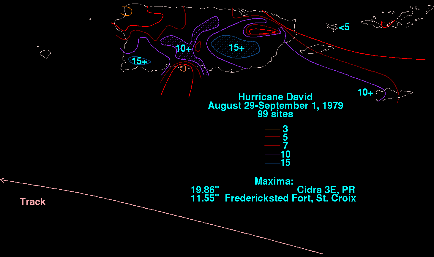 Hurricane David was originally going to hit the south coast of Puerto Rico, but a change in course in the middle of the night spared it the damage that the Dominican Republic suffered.
Though it did not hit Puerto Rico
, Hurricane David passed less than 100 miles (160 km) south of the island, bringing strong winds and heavy rainfall to the island. Portions of southwestern Puerto Rico experienced sustained winds of up to 85 mph (135 km/h), while the rest of the island received tropical storm-force winds. While passing by the island, the hurricane caused strong seas and torrential rainfall, amounting to 19.9 inches (505 mm) in Mayagüez, Puerto Rico
and up to 20 inches (510 mm) in the central mountainous region.
Despite remaining offshore, most of the island felt David's effects. Agricultural damage was severe, and combined with property damage, the hurricane was responsible for $70 million in losses ($200 million in 2005 USD). Following the storm, the FEMA declared the island a disaster area. In all, Hurricane David killed seven people in Puerto Rico, four of which resulted from electrocutions.
, David turned unexpectedly to the northwest, causing 125 mph (200 km/h) winds in Santo Domingo
and Category 5 winds elsewhere in the country. The storm caused torrential rainfall, resulting in extreme river flooding. The flooding swept away entire villages and isolated communities during the storm's onslaught. A rail-mounted container crane collapsed in Rio Haina at the sea-land terminal. Many roads in the country were either damaged or destroyed from the heavy rainfall, especially in the towns of Jarabacoa
, San Cristobal
, and Baní
.
Nearly 70% of the country's crops were destroyed from the torrential flooding. Extreme river flooding resulted in most of the country's 2,000 fatalities. One particularly deadly example of this was when a rampaging river in the mountainous village of Padre las Casas
swept away a church and a school, killing several hundred people who were sheltering there. The flooding destroyed thousands of houses, leaving over 200,000 homeless in the aftermath of the hurricane. President Antonio Guzmán Fernández
estimated the combination of agricultural, property, and industrial damage to amount to $1 billion ($2.8 billion in 2005 USD).
Neighboring Haiti
experienced very little from David, due to the hurricane's weakened state upon moving through the country.
amounting to $320 million ($900 million in 2005 USD). Prior to the hurricane's arrival, 400,000 evacuated from coastal areas. In total, David directly killed five in the United States, and was responsible for ten indirect deaths.
 Upon making landfall, David brought a storm surge of only two-four feet (0.6–1.2 m), due to its lack of strengthening and the obtuse angle at which it hit. In addition, David caused strong surf and moderate rainfall, amounting to a maximum of 8.92 inches (227 mm) in Vero Beach
. Though it made landfall as a Category 2 storm, the strongest winds were localized, and the highest reported wind occurred in Fort Pierce
, with 70 mph (115 km/h) sustained and 95 mph (155 km/h) gusts.
Because the hurricane remained near the coastline, Hurricane David failed to cause extreme damage in Florida. The storm's winds shattered windows in stores near the coast and caused property damage, including blowing the frame of the Palm Beach
Jai Alai
fronton and downing the 186-foot (57-m) WJNO AM radio tower in West Palm Beach
into the Intracoastal Waterway
. A few roofs were torn off, and numerous buildings were flooded from over six inches (150 mm) of rainfall. A 450-foot (140-m) crane was even snapped in two at the St. Lucie
nuclear power plant. The hurricane spawned over 10 tornadoes while passing over the state, though none caused deaths or injuries. Total damages in Florida amounted to $95 million ($270 million in 2005 USD), of which $30 million occurred in Palm Beach County
, mostly from crop damage.
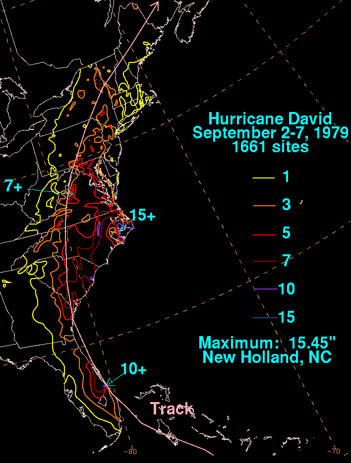
 Hurricane David made landfall in Georgia as a quickly weakening minimal hurricane, bringing a three–five foot (0.9–1.5 m) storm surge and heavy surf. Its inner core remained away from major cities, though Savannah
recorded sustained winds of 58 mph (93 km/h) and wind gusts of 68 mph (109 km/h). No major damage occurred in Savannah. High winds downed numerous power lines, leaving many without power for up to two weeks after the storm. Offshore, strong seas disrupted a portion of the coastal reef by moving a sunken ship 300 feet (90 m). Overall, Hurricane David was responsible for minor damage and two casualties from its heavy surf.
and a 70 mph (113 km/h) wind gust in Hilton Head Island
. Similar winds occurred in North Carolina, and lesser readings were recorded throughout the northeastern United States
, excluding a 174 mph (280 km/h) wind gust on Mount Washington
in New Hampshire
. In addition, David dropped heavy rainfall along its path, peaking at 10.73 inches (273 mm) in Cape Hatteras
, North Carolina, with widespread reports of over five inches (130 mm). Storm surge was moderate, peaking at 8.8 feet (2.7 m) in Charleston and up to five feet (1.5 m) along much of the eastern United States coastline
.
Overall, damage was light in most areas, though it was very widespread. High winds and rain downed power lines in the New York City
area, leaving 2.5 million people without electricity during the storm's passage. David also caused minor to moderate beach erosion, as well as widespread crop damage from the flooding. In addition, the hurricane spawned numerous tornadoes while moving through the Mid-Atlantic and New England. In Virginia
eight tornadoes formed across the southeastern portion of the state, of which six were F2's or greater on the Fujita scale
. The tornadoes caused one death, 19 injuries, damaged 270 homes, and destroyed three homes, amounting to $6 million ($20 million in 2005 USD) in losses. In Maryland
, David's outer bands formed seven tornadoes. In New Castle County, Delaware
, one tornado damaged numerous homes and injured five.
. A citizen named Fred White ended that by using a battery-operated ham radio to contact the world.
In response to the severe agricultural damage, the government initiated a food ration. By two months after the storm, assistance pledges amounted to over $37 million (1979 USD
) from various groups around the world. Similar to the aftermath of other natural disasters, the distribution of the aid raised concerns and accusations over the amount of food and material, or lack thereof, for the affected citizens. The Hurricane destroyed some important landmarks, including a significant part of the ruins of the Fort Young
which had stood since the 1770s.
Another occurrence less typical of the aftermath of other natural disasters was the looting. In supermarkets, seaports, and homes, what was not destroyed by the hurricanes was stolen in the weeks after the storm. This kind of lawlessness is occasionally seen, particularly in economically poor areas, in the aftermath of catastrophes such as Hurricane Hugo
, Hurricane Jeanne
, and Hurricane Katrina
.
One reporter who covered Hurricane David was Dick Baumbach, a journalist with TODAY newspaper, now known as Florida Today. He along with news photographer Scott Maclay followed the path of the hurricane from Miami to Central Florida. In Cocoa Beach, Baumbach decided to ride out the hurricane in his home with two other journalists. While it was a difficult and trying experience all three reporters survived and ended up winning numerous awards.
This hurricane also interrupted the filming of the movie 'Caddyshack' that was taking place at the Rolling Hills country Club near the Fort Lauderdale airport.
were the first male hurricane names to be retired, as the practice of alternating male and female hurricane names was introduced in the 1979 season.
The name David was retired following this storm because of its devastation and high death toll and will never be used again for an Atlantic hurricane. It was replaced with Danny
for the 1985 season
.
Tropical cyclone
A tropical cyclone is a storm system characterized by a large low-pressure center and numerous thunderstorms that produce strong winds and heavy rain. Tropical cyclones strengthen when water evaporated from the ocean is released as the saturated air rises, resulting in condensation of water vapor...
, second hurricane, and first major hurricane of the 1979 Atlantic hurricane season
1979 Atlantic hurricane season
The 1979 Atlantic hurricane season was the first in which the Atlantic hurricane naming list included both male and female names. It officially began on June 1 and lasted until November 30, and there was tropical cyclone activity in every month. The dates conventionally delimit the period of each...
. A Category 5 hurricane on the Saffir-Simpson Hurricane Scale
Saffir-Simpson Hurricane Scale
The Saffir–Simpson Hurricane Scale , or the Saffir–Simpson Hurricane Wind Scale , classifies hurricanes — Western Hemisphere tropical cyclones that exceed the intensities of tropical depressions and tropical storms — into five categories distinguished by the intensities of their sustained winds...
, David was among the deadliest hurricanes in the latter half of the 20th century, killing over 2,000 people in its path, mostly in the Dominican Republic
Dominican Republic
The Dominican Republic is a nation on the island of La Hispaniola, part of the Greater Antilles archipelago in the Caribbean region. The western third of the island is occupied by the nation of Haiti, making Hispaniola one of two Caribbean islands that are shared by two countries...
. As of 2010, it remains the only hurricane to make landfall on the Dominican Republic at Category 5 intensity.
David was a Cape Verde-type hurricane
Cape Verde-type hurricane
A Cape Verde-type hurricane is an Atlantic hurricane that develops near the Cape Verde islands, off the west coast of Africa. The average hurricane season has about two Cape Verde-type hurricanes, which are usually the largest and most intense storms of the season because they often have plenty of...
, traversing through the Lesser Antilles
Lesser Antilles
The Lesser Antilles are a long, partly volcanic island arc in the Western Hemisphere. Most of its islands form the eastern boundary of the Caribbean Sea with the Atlantic Ocean, with the remainder located in the southern Caribbean just north of South America...
, Greater Antilles
Greater Antilles
The Greater Antilles are one of three island groups in the Caribbean. Comprising Cuba, Jamaica, Hispaniola , and Puerto Rico, the Greater Antilles constitute almost 90% of the land mass of the entire West Indies.-Greater Antilles in context :The islands of the Caribbean Sea, collectively known as...
, and East Coast of the United States
East Coast of the United States
The East Coast of the United States, also known as the Eastern Seaboard, refers to the easternmost coastal states in the United States, which touch the Atlantic Ocean and stretch up to Canada. The term includes the U.S...
during late August and early September. With winds of 175 mph (280 km/h), Hurricane David was the strongest hurricane to strike the Dominican Republic in recorded history, and the deadliest since the 1930 Dominican Republic Hurricane
1930 Dominican Republic Hurricane
The 1930 Dominican Republic Hurricane, also known as Hurricane San Zenon, is the fifth deadliest Atlantic hurricane on record. The second of two known tropical cyclones in the 1930 Atlantic hurricane season, the hurricane was first observed on August 29 to the east of the Lesser Antilles...
. Also, the hurricane was the strongest to hit Dominica
Dominica
Dominica , officially the Commonwealth of Dominica, is an island nation in the Lesser Antilles region of the Caribbean Sea, south-southeast of Guadeloupe and northwest of Martinique. Its size is and the highest point in the country is Morne Diablotins, which has an elevation of . The Commonwealth...
in the 20th century, and was the deadliest Dominica
Dominica
Dominica , officially the Commonwealth of Dominica, is an island nation in the Lesser Antilles region of the Caribbean Sea, south-southeast of Guadeloupe and northwest of Martinique. Its size is and the highest point in the country is Morne Diablotins, which has an elevation of . The Commonwealth...
n tropical cyclone since a hurricane killed over 200 in September of the 1834 season. David was the second male name for a tropical storm since 1952, first to reach Category 5 intensity and the first to be retired.
Meteorological history
A tropical waveTropical wave
Tropical waves, easterly waves, or tropical easterly waves, also known as African easterly waves in the Atlantic region, are a type of atmospheric trough, an elongated area of relatively low air pressure, oriented north to south, which move from east to west across the tropics causing areas of...
that moved off the coast of Africa on August 22 developed into a tropical depression which is an area of low pressure that surrounding areas of High pressure in the central Atlantic are coming into make the tropical depression on August 25 about 800 miles (1,300 km) east of the Windward Islands
Windward Islands
The Windward Islands are the southern islands of the Lesser Antilles, within the West Indies.-Name and geography:The Windward Islands are called such because they were more windward to sailing ships arriving in the New World than the Leeward Islands, given that the prevailing trade winds in the...
. The strong subtropical ridge to the north forced the new depression westward, where favorable conditions allowed it to strengthen to Tropical Storm David on August 26. David continued to strengthen, becoming a hurricane on August 27. As it moved west-northwestward on from August 27–28, it rapidly intensified to a 150 mph (240 km/h) major hurricane. It weakened slightly to a 140 mph (225 km/h) hurricane, but restrengthened by the time David ravaged the tiny Leeward Island
Leeward Islands
The Leeward Islands are a group of islands in the West Indies. They are the northern islands of the Lesser Antilles chain. As a group they start east of Puerto Rico and reach southward to Dominica. They are situated where the northeastern Caribbean Sea meets the western Atlantic Ocean...
of Dominica
Dominica
Dominica , officially the Commonwealth of Dominica, is an island nation in the Lesser Antilles region of the Caribbean Sea, south-southeast of Guadeloupe and northwest of Martinique. Its size is and the highest point in the country is Morne Diablotins, which has an elevation of . The Commonwealth...
on the 29th.
David continued west-northwest, and became a Category 5 hurricane in the northeast Caribbean Sea
Caribbean Sea
The Caribbean Sea is a sea of the Atlantic Ocean located in the tropics of the Western hemisphere. It is bounded by Mexico and Central America to the west and southwest, to the north by the Greater Antilles, and to the east by the Lesser Antilles....
, reaching peak intensity with maximum sustained winds of 175 mph (280 km/h) and minimum central pressure of 924 mbar
Bar (unit)
The bar is a unit of pressure equal to 100 kilopascals, and roughly equal to the atmospheric pressure on Earth at sea level. Other units derived from the bar are the megabar , kilobar , decibar , centibar , and millibar...
(hPa) on August 30. An upper-level trough pulled David northward into Hispaniola
Hispaniola
Hispaniola is a major island in the Caribbean, containing the two sovereign states of the Dominican Republic and Haiti. The island is located between the islands of Cuba to the west and Puerto Rico to the east, within the hurricane belt...
as a Category 5 hurricane on the August 31. The eye passed almost directly over Santo Domingo
Santo Domingo
Santo Domingo, known officially as Santo Domingo de Guzmán, is the capital and largest city in the Dominican Republic. Its metropolitan population was 2,084,852 in 2003, and estimated at 3,294,385 in 2010. The city is located on the Caribbean Sea, at the mouth of the Ozama River...
, capital of the Dominican Republic
Dominican Republic
The Dominican Republic is a nation on the island of La Hispaniola, part of the Greater Antilles archipelago in the Caribbean region. The western third of the island is occupied by the nation of Haiti, making Hispaniola one of two Caribbean islands that are shared by two countries...
with over a million people. The storm crossed over the island and emerged as a weak hurricane after drenching the islands.
Windward Passage
The Windward Passage is a strait in the Caribbean Sea, between the islands of Cuba and Hispaniola. The strait specifically lies between the easternmost region of Cuba and the northwest of Haiti.80km wide, the Windward Passage has a threshold depth of 1,700m...
, David struck eastern Cuba
Cuba
The Republic of Cuba is an island nation in the Caribbean. The nation of Cuba consists of the main island of Cuba, the Isla de la Juventud, and several archipelagos. Havana is the largest city in Cuba and the country's capital. Santiago de Cuba is the second largest city...
as a minimal hurricane on September 1. It weakened to a tropical storm over land, but quickly re-strengthened as it again reached open waters. David turned to the northwest along the western periphery of the subtropical ridge, and re-intensified to a 100 mph (160 km/h) Category 2 hurricane while over the Bahamas, where it caused heavy damage. Despite initial forecasts of a Miami, Florida
Miami, Florida
Miami is a city located on the Atlantic coast in southeastern Florida and the county seat of Miami-Dade County, the most populous county in Florida and the eighth-most populous county in the United States with a population of 2,500,625...
landfall, the hurricane turned to the north-northwest just before landfall to strike near West Palm Beach, Florida
West Palm Beach, Florida
West Palm Beach, is a city located on the Atlantic coast in southeastern Florida and is the most populous city in and county seat of Palm Beach County, the third most populous county in Florida with a 2010 population of 1,320,134. The city is also the oldest incorporated municipality in South Florida...
on September 3. It paralleled the Florida coastline just inland until emerging into the western Atlantic Ocean at New Smyrna Beach, Florida
New Smyrna Beach, Florida
New Smyrna Beach is a city in Volusia County, Florida, United States. The population was 20,048 according to the 2000 census. As of 2007, the population recorded by the U.S. Census Bureau is 23,161.-History:...
later on September 3. David continued to the north-northwest, and made its final landfall just south of Savannah, Georgia
Savannah, Georgia
Savannah is the largest city and the county seat of Chatham County, in the U.S. state of Georgia. Established in 1733, the city of Savannah was the colonial capital of the Province of Georgia and later the first state capital of Georgia. Today Savannah is an industrial center and an important...
as a minimal hurricane on September 5. It turned to the northeast while weakening over land, and became extratropical on the 6th over New York
New York
New York is a state in the Northeastern region of the United States. It is the nation's third most populous state. New York is bordered by New Jersey and Pennsylvania to the south, and by Connecticut, Massachusetts and Vermont to the east...
. As an extratropical storm, David continued to the northeast over New England
New England
New England is a region in the northeastern corner of the United States consisting of the six states of Maine, New Hampshire, Vermont, Massachusetts, Rhode Island, and Connecticut...
and the Canadian Maritimes. David intensified once more as it crossed the far north Atlantic, clipping northwestern Iceland
Iceland
Iceland , described as the Republic of Iceland, is a Nordic and European island country in the North Atlantic Ocean, on the Mid-Atlantic Ridge. Iceland also refers to the main island of the country, which contains almost all the population and almost all the land area. The country has a population...
before moving eastward well north of the Faroe Islands
Faroe Islands
The Faroe Islands are an island group situated between the Norwegian Sea and the North Atlantic Ocean, approximately halfway between Scotland and Iceland. The Faroe Islands are a self-governing territory within the Kingdom of Denmark, along with Denmark proper and Greenland...
on September 10.
Preparations
David was originally expected to hit BarbadosBarbados
Barbados is an island country in the Lesser Antilles. It is in length and as much as in width, amounting to . It is situated in the western area of the North Atlantic and 100 kilometres east of the Windward Islands and the Caribbean Sea; therein, it is about east of the islands of Saint...
and spare Dominica
Dominica
Dominica , officially the Commonwealth of Dominica, is an island nation in the Lesser Antilles region of the Caribbean Sea, south-southeast of Guadeloupe and northwest of Martinique. Its size is and the highest point in the country is Morne Diablotins, which has an elevation of . The Commonwealth...
in the process. However, even as it became increasingly clear that David was headed for the island, residents did not appear to take the situation seriously. This can be partly attributed to the fact that local radio warnings were minimal and disaster preparedness schemes were essentially non-existent. Furthermore, Dominica had not experienced a major hurricane since 1930, thus leading to complacency amongst much of the population. This proved to have disastrous consequences for the island nation.
Some 400,000 people evacuated in the United States
United States
The United States of America is a federal constitutional republic comprising fifty states and a federal district...
in anticipation of David, including 300,000 in southeastern Florida
Florida
Florida is a state in the southeastern United States, located on the nation's Atlantic and Gulf coasts. It is bordered to the west by the Gulf of Mexico, to the north by Alabama and Georgia and to the east by the Atlantic Ocean. With a population of 18,801,310 as measured by the 2010 census, it...
due to a predicted landfall between the Florida Keys
Florida Keys
The Florida Keys are a coral archipelago in southeast United States. They begin at the southeastern tip of the Florida peninsula, about south of Miami, and extend in a gentle arc south-southwest and then westward to Key West, the westernmost of the inhabited islands, and on to the uninhabited Dry...
and Palm Beach
Palm Beach, Florida
The Town of Palm Beach is an incorporated town in Palm Beach County, Florida, United States. The Intracoastal Waterway separates it from the neighboring cities of West Palm Beach and Lake Worth...
. Of those, 78,000 fled to shelters, while others either stayed at a friend's house further inland or traveled northward. Making landfall during Labor Day
Labor Day
Labor Day is a United States federal holiday observed on the first Monday in September that celebrates the economic and social contributions of workers.-History:...
weekend, David forced the cancellations of many activities in the greater Miami
Miami, Florida
Miami is a city located on the Atlantic coast in southeastern Florida and the county seat of Miami-Dade County, the most populous county in Florida and the eighth-most populous county in the United States with a population of 2,500,625...
area.
Impact
| Deaths from David (totals may not match) |
|
|---|---|
| Region | Deaths |
| Dominica Dominica Dominica , officially the Commonwealth of Dominica, is an island nation in the Lesser Antilles region of the Caribbean Sea, south-southeast of Guadeloupe and northwest of Martinique. Its size is and the highest point in the country is Morne Diablotins, which has an elevation of . The Commonwealth... |
56 |
| Puerto Rico Puerto Rico Puerto Rico , officially the Commonwealth of Puerto Rico , is an unincorporated territory of the United States, located in the northeastern Caribbean, east of the Dominican Republic and west of both the United States Virgin Islands and the British Virgin Islands.Puerto Rico comprises an... |
7 |
| Dominican Republic Dominican Republic The Dominican Republic is a nation on the island of La Hispaniola, part of the Greater Antilles archipelago in the Caribbean region. The western third of the island is occupied by the nation of Haiti, making Hispaniola one of two Caribbean islands that are shared by two countries... |
2,000+ |
| United States United States The United States of America is a federal constitutional republic comprising fifty states and a federal district... |
5 |
| Total | 2,068+ |
David is believed to have been responsible for 2,068 deaths, making it one of the deadliest hurricanes of the modern era. It caused torrential damage across its path, most of which occurred in the Dominican Republic
Dominican Republic
The Dominican Republic is a nation on the island of La Hispaniola, part of the Greater Antilles archipelago in the Caribbean region. The western third of the island is occupied by the nation of Haiti, making Hispaniola one of two Caribbean islands that are shared by two countries...
where the hurricane made landfall as a Category 5
Category 5
Category 5 may refer to:*Category 5 , an album from rock band, FireHouse*Category 5 cable, used for carrying data*Category 5 computer virus, as classified by Symantec Corporation*Category 5 Records, a record label...
hurricane.
Dominica
In the days prior to hitting DominicaDominica
Dominica , officially the Commonwealth of Dominica, is an island nation in the Lesser Antilles region of the Caribbean Sea, south-southeast of Guadeloupe and northwest of Martinique. Its size is and the highest point in the country is Morne Diablotins, which has an elevation of . The Commonwealth...
, forecasters thought David would spare Dominica and hit Barbados
Barbados
Barbados is an island country in the Lesser Antilles. It is in length and as much as in width, amounting to . It is situated in the western area of the North Atlantic and 100 kilometres east of the Windward Islands and the Caribbean Sea; therein, it is about east of the islands of Saint...
instead. However, a turn in the hours before moving through the area caused the 150 mph (240 km/h) hurricane to make a direct hit on the southern part of Dominica. During the storm's onslaught, David dropped up to 10 inches (250 mm) of rain, causing numerous landslides on the mountainous island. Hours of hurricane force winds severely eroded the coastlines and washed out coastal roads.
Damage was greatest in the southwest portion of the island, especially in the capital city, Roseau
Roseau
-Architecture:The central district of Roseau is tightly packed with small and large houses and even larger modern concrete structures. There is little green or open space situated within the city, and this is even more so today, as many of the courtyards which was once commonplace within the city...
, which resembled an air raid target after the storm's passage. Strong winds from Hurricane David destroyed or damaged 80% of the homes on the island, leaving 75% of the population homeless, with many others temporarily homeless in the immediate aftermath. In addition, the rainfall turned rivers into torrents, sweeping away everything in their path to the sea. Power lines were completely ripped out, causing the water system to stop as well.
HMS Fife (a Royal Navy County Class Destroyer) was on its way back to the United Kingdom
United Kingdom
The United Kingdom of Great Britain and Northern IrelandIn the United Kingdom and Dependencies, other languages have been officially recognised as legitimate autochthonous languages under the European Charter for Regional or Minority Languages...
when the hurricane struck, and was turned back to provide emergency aid to the island. Sailing through mountainous seas The Fife docked in the main harbor at Roseau without assistance, and was the only outside help for several days. The crew provided work details and medical parties to offer assistance to the island and concentrated on the hospital buildings, the airstrip, and restoring power and water. The ship's helicopter (called Humphrey) took medical aid into the hills to assist people who were cut off from getting to other help by fallen trees. The ship also used its radio systems to broadcast news and music to the island to inform the population of what was being done and how to get assistance. This was the first time a Royal Navy ship had provided a public broadcast news service.
Most severely damaged was the agricultural industry. The worst loss in agriculture was from bananas and coconuts, which about 75% of the crop was destroyed. Banana fields were completely destroyed, and in the southern portion of the island most coconut trees were blown down. Citrus trees fared better, due to the small yet sturdy nature of the tree. In addition, David's winds uprooted many trees on the tops of mountains, leaving them bare and damaging the ecosystem by disrupting the water levels.
In all, 56 people died in Dominica and 180 were injured. Property and agricultural damage figures in Dominica are unknown.
Lesser Antilles
Aside from Dominica, other islands in the Lesser AntillesLesser Antilles
The Lesser Antilles are a long, partly volcanic island arc in the Western Hemisphere. Most of its islands form the eastern boundary of the Caribbean Sea with the Atlantic Ocean, with the remainder located in the southern Caribbean just north of South America...
experienced minor to moderate damage. Just to the south of Dominica, David brought Martinique
Martinique
Martinique is an island in the eastern Caribbean Sea, with a land area of . Like Guadeloupe, it is an overseas region of France, consisting of a single overseas department. To the northwest lies Dominica, to the south St Lucia, and to the southeast Barbados...
winds of up to 100 mph (160 km/h) and 140 mph (220 km/h) sustained gust in the north east of the coast of the Caravelle. The capital, Fort-de-France
Fort-de-France
Fort-de-France is the capital of France's Caribbean overseas department of Martinique. It is also one of the major cities in the Caribbean. Exports include sugar, rum, tinned fruit, and cacao.-Geography:...
reported wave heights of 15 feet (4.5 m) and experienced strong tropical storm sustained winds at 56 mph (90 km/h) and gust at 78 mph (126 km/h). David's strong winds caused severe crop damage, mostly to bananas, amounting to $50 million ($150 million in 2007 USD) in losses. Though no deaths were reported, the hurricane caused 20 to 30 injuries and left 500 homeless.
Guadeloupe
Guadeloupe
Guadeloupe is an archipelago located in the Leeward Islands, in the Lesser Antilles, with a land area of 1,628 square kilometres and a population of 400,000. It is the first overseas region of France, consisting of a single overseas department. As with the other overseas departments, Guadeloupe...
experienced moderate to extensive damage on the island of Basse-Terre Island
Basse-Terre Island
Basse-Terre Island is the name of the western-half of Guadeloupe proper, in the Lesser Antilles. It is separated from the other half of Guadeloupe proper, Grande-Terre, by a narrow sea channel called the Rivière Salée ....
. There, the banana crop was completely destroyed, and combined with other losses, crop damage amounted to $100 million ($280 million in 2005 USD). David caused no deaths, a few injuries, and left several hundred homeless. Nearby, Marie-Galante
Marie-Galante
Marie-Galante is an island of the Caribbean Sea located at the south of Guadeloupe and at north of Dominica. Marie-Galante is a dependence of Guadeloupe which is a french overseas department....
and Les Saintes reported extreme damage while Grande-Terre
Grande-Terre
Grande-Terre is an island in the Guadeloupe, separated by Basse-Terre Island by a salt river. Grande-Terre's northernmost point, Pointe de la Grande Vigie, is also the northernmost point in Guadeloupe....
had moderate damages.
The island of St. Croix
Saint Croix, U.S. Virgin Islands
Saint Croix is an island in the Caribbean Sea, and a county and constituent district of the United States Virgin Islands , an unincorporated territory of the United States. Formerly the Danish West Indies, they were sold to the United States by Denmark in the Treaty of the Danish West Indies of...
in the U. S. Virgin Islands
United States Virgin Islands
The Virgin Islands of the United States are a group of islands in the Caribbean that are an insular area of the United States. The islands are geographically part of the Virgin Islands archipelago and are located in the Leeward Islands of the Lesser Antilles.The U.S...
experienced significant rainfall amounting to 10–12 inches (250–300 mm) but fairly minor damages.
Puerto Rico
Though it did not hit Puerto Rico
Puerto Rico
Puerto Rico , officially the Commonwealth of Puerto Rico , is an unincorporated territory of the United States, located in the northeastern Caribbean, east of the Dominican Republic and west of both the United States Virgin Islands and the British Virgin Islands.Puerto Rico comprises an...
, Hurricane David passed less than 100 miles (160 km) south of the island, bringing strong winds and heavy rainfall to the island. Portions of southwestern Puerto Rico experienced sustained winds of up to 85 mph (135 km/h), while the rest of the island received tropical storm-force winds. While passing by the island, the hurricane caused strong seas and torrential rainfall, amounting to 19.9 inches (505 mm) in Mayagüez, Puerto Rico
Mayagüez, Puerto Rico
Mayagüez is the eighth-largest municipality of Puerto Rico. Originally founded as "Nuestra Señora de la Candelaria" it is also known as "La Sultana del Oeste" , "Ciudad de las Aguas Puras" , or "Ciudad del Mangó"...
and up to 20 inches (510 mm) in the central mountainous region.
Despite remaining offshore, most of the island felt David's effects. Agricultural damage was severe, and combined with property damage, the hurricane was responsible for $70 million in losses ($200 million in 2005 USD). Following the storm, the FEMA declared the island a disaster area. In all, Hurricane David killed seven people in Puerto Rico, four of which resulted from electrocutions.
Dominican Republic
Upon making landfall in the Dominican RepublicDominican Republic
The Dominican Republic is a nation on the island of La Hispaniola, part of the Greater Antilles archipelago in the Caribbean region. The western third of the island is occupied by the nation of Haiti, making Hispaniola one of two Caribbean islands that are shared by two countries...
, David turned unexpectedly to the northwest, causing 125 mph (200 km/h) winds in Santo Domingo
Santo Domingo
Santo Domingo, known officially as Santo Domingo de Guzmán, is the capital and largest city in the Dominican Republic. Its metropolitan population was 2,084,852 in 2003, and estimated at 3,294,385 in 2010. The city is located on the Caribbean Sea, at the mouth of the Ozama River...
and Category 5 winds elsewhere in the country. The storm caused torrential rainfall, resulting in extreme river flooding. The flooding swept away entire villages and isolated communities during the storm's onslaught. A rail-mounted container crane collapsed in Rio Haina at the sea-land terminal. Many roads in the country were either damaged or destroyed from the heavy rainfall, especially in the towns of Jarabacoa
Jarabacoa
Jarabacoa is a town and the second largest municipality in La Vega Province, Dominican Republic.- History :In 1805, during the Haitian invasion of the Cibao, survivors from the massacres of Santiago de los Caballeros and La Vega escaped to the mountains of the Cordillera Central and settled in the...
, San Cristobal
San Cristóbal, Dominican Republic
San Cristóbal is a municipality and the capital of the San Cristóbal province in the Dominican Republic. Within the municipality there is one municipal district : Hato Damas.-Sectors:*5 de abril*Canastica*El Pomier...
, and Baní
Baní
Baní is a capital town of the Peravia Province, Dominican Republic. It is the commercial and manufacturing center in a region producing bananas and coffee.- Overview :...
.
Nearly 70% of the country's crops were destroyed from the torrential flooding. Extreme river flooding resulted in most of the country's 2,000 fatalities. One particularly deadly example of this was when a rampaging river in the mountainous village of Padre las Casas
Padre las Casas
Padre las Casas is a town in the Azua province of the Dominican Republic.- Sources :* – World-Gazetteer.com...
swept away a church and a school, killing several hundred people who were sheltering there. The flooding destroyed thousands of houses, leaving over 200,000 homeless in the aftermath of the hurricane. President Antonio Guzmán Fernández
Antonio Guzmán Fernández
Silvestre Antonio Guzmán Fernández was a Dominican businessman and a politician. He was the 46th President of the Dominican Republic, from 1978 to 1982.- Early life :Antonio Guzmán was born in the town of La Vega...
estimated the combination of agricultural, property, and industrial damage to amount to $1 billion ($2.8 billion in 2005 USD).
Neighboring Haiti
Haiti
Haiti , officially the Republic of Haiti , is a Caribbean country. It occupies the western, smaller portion of the island of Hispaniola, in the Greater Antillean archipelago, which it shares with the Dominican Republic. Ayiti was the indigenous Taíno or Amerindian name for the island...
experienced very little from David, due to the hurricane's weakened state upon moving through the country.
Bahamas
While passing through the Bahamas, David brought 70–80 mph (115–130 km/h) winds to Andros Island as the eye crossed the archipelago. David, though still disorganized, produced heavy rainfall in the country peaking at 8 inches (200 mm). Strong wind gusts uprooted trees, and overall damage was minimal.United States
David produced widespread damage across the United StatesUnited States
The United States of America is a federal constitutional republic comprising fifty states and a federal district...
amounting to $320 million ($900 million in 2005 USD). Prior to the hurricane's arrival, 400,000 evacuated from coastal areas. In total, David directly killed five in the United States, and was responsible for ten indirect deaths.
Florida
Vero Beach, Florida
Vero Beach is a city in Indian River County, Florida, USA. According to the U.S. Census Bureau's 2006 estimates, the city had a population of 16,939. It is the county seat of Indian River County...
. Though it made landfall as a Category 2 storm, the strongest winds were localized, and the highest reported wind occurred in Fort Pierce
Fort Pierce, Florida
Fort Pierce, also spelled Ft. Pierce, is a city in St. Lucie County, Florida, USA. It is known as The Sunrise City. The population was 37,959 at the 2004 census. As of 2008, the population recorded by the U.S. Census Bureau is 41,000. It is the county seat of St. Lucie County.Fort Pierce is part...
, with 70 mph (115 km/h) sustained and 95 mph (155 km/h) gusts.
Because the hurricane remained near the coastline, Hurricane David failed to cause extreme damage in Florida. The storm's winds shattered windows in stores near the coast and caused property damage, including blowing the frame of the Palm Beach
Palm Beach, Florida
The Town of Palm Beach is an incorporated town in Palm Beach County, Florida, United States. The Intracoastal Waterway separates it from the neighboring cities of West Palm Beach and Lake Worth...
Jai Alai
Jai alai
Jai alai is a sport involving a ball bounced off a walled space. It is a variety of Basque Pelota. The term, coined by Serafin Baroja in 1875, is also often loosely applied to the fronton where the sport is played...
fronton and downing the 186-foot (57-m) WJNO AM radio tower in West Palm Beach
West Palm Beach, Florida
West Palm Beach, is a city located on the Atlantic coast in southeastern Florida and is the most populous city in and county seat of Palm Beach County, the third most populous county in Florida with a 2010 population of 1,320,134. The city is also the oldest incorporated municipality in South Florida...
into the Intracoastal Waterway
Intracoastal Waterway
The Intracoastal Waterway is a 3,000-mile waterway along the Atlantic and Gulf coasts of the United States. Some lengths consist of natural inlets, salt-water rivers, bays, and sounds; others are artificial canals...
. A few roofs were torn off, and numerous buildings were flooded from over six inches (150 mm) of rainfall. A 450-foot (140-m) crane was even snapped in two at the St. Lucie
St. Lucie, Florida
St. Lucie is a village in St. Lucie County, Florida, United States. The population was 604 at the 2000 census. As of 2004, the population recorded by the U.S. Census Bureau is 597 . It is part of the Port St. Lucie Metropolitan Statistical Area.-Geography:...
nuclear power plant. The hurricane spawned over 10 tornadoes while passing over the state, though none caused deaths or injuries. Total damages in Florida amounted to $95 million ($270 million in 2005 USD), of which $30 million occurred in Palm Beach County
Palm Beach County, Florida
Palm Beach County is the largest county in the state of Florida in total area, and third in population. As of 2010, the county's estimated population was 1,320,134, making it the twenty-eighth most populous in the United States...
, mostly from crop damage.
Georgia
Savannah, Georgia
Savannah is the largest city and the county seat of Chatham County, in the U.S. state of Georgia. Established in 1733, the city of Savannah was the colonial capital of the Province of Georgia and later the first state capital of Georgia. Today Savannah is an industrial center and an important...
recorded sustained winds of 58 mph (93 km/h) and wind gusts of 68 mph (109 km/h). No major damage occurred in Savannah. High winds downed numerous power lines, leaving many without power for up to two weeks after the storm. Offshore, strong seas disrupted a portion of the coastal reef by moving a sunken ship 300 feet (90 m). Overall, Hurricane David was responsible for minor damage and two casualties from its heavy surf.
Mid-Atlantic and New England
Upon entering South Carolina, David retained winds of up to hurricane force, though the highest recorded was 43 mph (69 km/h) sustained in CharlestonCharleston, South Carolina
Charleston is the second largest city in the U.S. state of South Carolina. It was made the county seat of Charleston County in 1901 when Charleston County was founded. The city's original name was Charles Towne in 1670, and it moved to its present location from a location on the west bank of the...
and a 70 mph (113 km/h) wind gust in Hilton Head Island
Hilton Head Island, South Carolina
Hilton Head Island or Hilton Head is a resort town in Beaufort County, South Carolina, United States. It is north of Savannah, Georgia, and south of Charleston. The island gets its name from Captain William Hilton...
. Similar winds occurred in North Carolina, and lesser readings were recorded throughout the northeastern United States
Northeastern United States
The Northeastern United States is a region of the United States as defined by the United States Census Bureau.-Composition:The region comprises nine states: the New England states of Connecticut, Maine, Massachusetts, New Hampshire, Rhode Island and Vermont; and the Mid-Atlantic states of New...
, excluding a 174 mph (280 km/h) wind gust on Mount Washington
Mount Washington (New Hampshire)
Mount Washington is the highest peak in the Northeastern United States at , famous for dangerously erratic weather. For 76 years, a weather observatory on the summit held the record for the highest wind gust directly measured at the Earth's surface, , on the afternoon of April 12, 1934...
in New Hampshire
New Hampshire
New Hampshire is a state in the New England region of the northeastern United States of America. The state was named after the southern English county of Hampshire. It is bordered by Massachusetts to the south, Vermont to the west, Maine and the Atlantic Ocean to the east, and the Canadian...
. In addition, David dropped heavy rainfall along its path, peaking at 10.73 inches (273 mm) in Cape Hatteras
Cape Hatteras
Cape Hatteras is a cape on the coast of North Carolina. It is the point that protrudes the farthest to the southeast along the northeast-to-southwest line of the Atlantic coast of North America...
, North Carolina, with widespread reports of over five inches (130 mm). Storm surge was moderate, peaking at 8.8 feet (2.7 m) in Charleston and up to five feet (1.5 m) along much of the eastern United States coastline
East Coast of the United States
The East Coast of the United States, also known as the Eastern Seaboard, refers to the easternmost coastal states in the United States, which touch the Atlantic Ocean and stretch up to Canada. The term includes the U.S...
.
Overall, damage was light in most areas, though it was very widespread. High winds and rain downed power lines in the New York City
New York City
New York is the most populous city in the United States and the center of the New York Metropolitan Area, one of the most populous metropolitan areas in the world. New York exerts a significant impact upon global commerce, finance, media, art, fashion, research, technology, education, and...
area, leaving 2.5 million people without electricity during the storm's passage. David also caused minor to moderate beach erosion, as well as widespread crop damage from the flooding. In addition, the hurricane spawned numerous tornadoes while moving through the Mid-Atlantic and New England. In Virginia
Virginia
The Commonwealth of Virginia , is a U.S. state on the Atlantic Coast of the Southern United States. Virginia is nicknamed the "Old Dominion" and sometimes the "Mother of Presidents" after the eight U.S. presidents born there...
eight tornadoes formed across the southeastern portion of the state, of which six were F2's or greater on the Fujita scale
Fujita scale
The Fujita scale , or Fujita-Pearson scale, is a scale for rating tornado intensity, based primarily on the damage tornadoes inflict on human-built structures and vegetation...
. The tornadoes caused one death, 19 injuries, damaged 270 homes, and destroyed three homes, amounting to $6 million ($20 million in 2005 USD) in losses. In Maryland
Maryland
Maryland is a U.S. state located in the Mid Atlantic region of the United States, bordering Virginia, West Virginia, and the District of Columbia to its south and west; Pennsylvania to its north; and Delaware to its east...
, David's outer bands formed seven tornadoes. In New Castle County, Delaware
New Castle County, Delaware
New Castle County is the northernmost of the three counties of the U.S. state of Delaware. As of 2010 its population was 538,479, an increase of 7.6% over the previous decade. The county seat is Wilmington. The center of population of Delaware is located in New Castle County, in the town of...
, one tornado damaged numerous homes and injured five.
Dominica
Immediately after the storm, lack of power prevented communications and the outside world had little knowledge of the extent of the damage in DominicaDominica
Dominica , officially the Commonwealth of Dominica, is an island nation in the Lesser Antilles region of the Caribbean Sea, south-southeast of Guadeloupe and northwest of Martinique. Its size is and the highest point in the country is Morne Diablotins, which has an elevation of . The Commonwealth...
. A citizen named Fred White ended that by using a battery-operated ham radio to contact the world.
In response to the severe agricultural damage, the government initiated a food ration. By two months after the storm, assistance pledges amounted to over $37 million (1979 USD
United States dollar
The United States dollar , also referred to as the American dollar, is the official currency of the United States of America. It is divided into 100 smaller units called cents or pennies....
) from various groups around the world. Similar to the aftermath of other natural disasters, the distribution of the aid raised concerns and accusations over the amount of food and material, or lack thereof, for the affected citizens. The Hurricane destroyed some important landmarks, including a significant part of the ruins of the Fort Young
Fort Young Hotel
Fort Young Hotel is a hotel on the quayside of Roseau, Dominica, located in the southern part of the capital next to Garraway Hotel and Dominica Museum and Roseau Public Library, just south of the Governor's Residence and Roseau Cathedral...
which had stood since the 1770s.
Another occurrence less typical of the aftermath of other natural disasters was the looting. In supermarkets, seaports, and homes, what was not destroyed by the hurricanes was stolen in the weeks after the storm. This kind of lawlessness is occasionally seen, particularly in economically poor areas, in the aftermath of catastrophes such as Hurricane Hugo
Hurricane Hugo
Hurricane Hugo was a classical, destructive and rare Cape Verde-type hurricane which struck the Caribbean islands of Guadeloupe, Montserrat, St. Croix, Puerto Rico and the USA mainland in South Carolina as a Category 4 hurricane during September of the 1989 Atlantic hurricane season...
, Hurricane Jeanne
Hurricane Jeanne
Hurricane Jeanne was the deadliest hurricane in the 2004 Atlantic hurricane season. It was the tenth named storm, the seventh hurricane, and the fifth major hurricane of the season, as well as the third hurricane and fourth named storm of the season to make landfall in Florida...
, and Hurricane Katrina
Hurricane Katrina
Hurricane Katrina of the 2005 Atlantic hurricane season was a powerful Atlantic hurricane. It is the costliest natural disaster, as well as one of the five deadliest hurricanes, in the history of the United States. Among recorded Atlantic hurricanes, it was the sixth strongest overall...
.
United States
Despite the casualties and damages attributed to David, the storm's effects were not as bad as in other countries. In particular, South Florida escaped relatively lightly. Because of this, NHC Director Neil Frank was accused of overly stirring up panic before the arrival of David: two local psychiatrists even claimed that the experience would make residents more complacent towards future storms. However, the NHC defended their methods, with Neil Frank stating: "If we hadn't [raised public alarm] and our predictions had been more accurate, the consequences would have been disastrous."One reporter who covered Hurricane David was Dick Baumbach, a journalist with TODAY newspaper, now known as Florida Today. He along with news photographer Scott Maclay followed the path of the hurricane from Miami to Central Florida. In Cocoa Beach, Baumbach decided to ride out the hurricane in his home with two other journalists. While it was a difficult and trying experience all three reporters survived and ended up winning numerous awards.
This hurricane also interrupted the filming of the movie 'Caddyshack' that was taking place at the Rolling Hills country Club near the Fort Lauderdale airport.
Retirement
Hurricanes David and FredericHurricane Frederic
Hurricane Frederic was the sixth tropical cyclone, third hurricane and second major hurricane of the 1979 Atlantic hurricane season. Frederic was the costliest hurricane to ever hit the U.S. Gulf Coast at that particular time...
were the first male hurricane names to be retired, as the practice of alternating male and female hurricane names was introduced in the 1979 season.
The name David was retired following this storm because of its devastation and high death toll and will never be used again for an Atlantic hurricane. It was replaced with Danny
Hurricane Danny (1985)
Hurricane Danny was a minimal Category 1 hurricane on the Saffir-Simpson hurricane scale that made landfall in the U.S. state of Louisiana. The fourth tropical cyclone and third hurricane of the 1985 Atlantic hurricane season, Danny originated from a tropical wave that moved into the western...
for the 1985 season
1985 Atlantic hurricane season
The 1985 Atlantic hurricane season had the most U.S. landfalling tropical cyclones since 1916. The season officially began on June 1, 1985, and lasted until November 30, 1985...
.
See also
- List of Atlantic hurricanes
- List of Category 5 Atlantic hurricanes