
.gif)
Hurricane Gordon (1994)
Encyclopedia
Hurricane Gordon was a long-lived and erratic late-season hurricane of the 1994 Atlantic hurricane season
. The twelfth and final tropical cyclone of the season, Gordon formed in the southwestern Caribbean
on November 8 after two tropical waves enhanced convection around in area of disturbed weather. Without strengthening, the storm made landfall Puerto Cabezas
, Nicaragua
. Later on November 10, the storm began to strengthen as it tracked further from land, it almost immediately strengthened into Tropical Storm Gordon, the seventh named named storm
that season. and the third hurricane of the 1994 Atlantic hurricane season
. Gordon also made landfalls in Jamaica
and Cuba
while a minimal tropical storm.
Following a winding path, it crossed Cuba, entering into the southwestern Atlantic, although it resembled a subtropical cyclone
. By the time it entered the Gulf of Mexico
it was a fully tropical cyclone again. Tropical Storm Gordon then headed north-northwestward and paralleled the coast of Cuba. Gordon later cross the Florida Keys
and also made landfall in Fort Myers, Florida
while still a weak tropical storm. Gordon began to strengthen further as it crossed Florida and entered the Atlantic Ocean. It had reached hurricane status for several hours on November 17 and 18 before weakening back and again heading for Florida. The storm quickly weakened and was only a tropical depression when it made a third landfall in Florida on November 20. Tropical Depression Gordon accelerated generally northward and dissipated by the next day over South Carolina
.
Gordon was a catastrophic storm in Haiti
, killing an estimated 1,122 people. In addition, Gordon also left 514 million (1994 USD, $ USD) when it passed through Cuba, Jamaica, Florida, and offshore of North Carolina
. Despite the high death toll and the damage, the name Gordon was not retired following the season.
persisted in the southwestern Caribbean Sea
during early November, which was enhanced by the passage of two tropical wave
s passing through the area. The second produced a low-level circulation just north of Panama
early on November 6. Convection slowly organized as it drifted northwestward, and by 1200 UTC
on November 7 the circulation displayed enough curvature to warrant initiating Dvorak technique
estimates. Late the next day, convection became more concentrated, and based on surface observations and satellite estimates the National Hurricane Center
estimates the system developed into Tropical Depression Twelve midday on November 8 while located a short distance off the southeast coast of Nicaragua
.
The depression continued drifting northwestward, and initially limited upper-level outflow
led to very slow organization. Its environment became more favorable, and by November 9 the system maintained banding features and increasingly defined outflow. Proximity to land prevented strengthening, and early on November 10 it made landfall
near Puerto Cabezas
, Nicaragua. Shortly thereafter, an upper-level trough
turned the depression to the northeast, and the depression intensified into Tropical Storm Gordon after reaching open waters. Tracking slowly north-northeastward, the circulation of the cyclone was initially very broad, covering much of the western Caribbean Sea, and its combination with southwesterly vertical wind shear
prevented significant strengthening. By November 12, the center was exposed due to the shear, though by later in the day the circulation became situated along the western edge of the deep convection. Early on November 13, Gordon struck Jamaica
near Kingston
as a minimal tropical storm, and accelerating northeastward the cyclone made landfall near Guantánamo Bay, Cuba
later that day.
Around the time of Gordon crossing Jamaica, an upper-level trough
spawned a low-level disturbance over the central Bahamas. From surface synoptic reports, the National Hurricane Center estimates Tropical Storm Gordon rapidly crossed Cuba and became the dominant system between Cuba and the Bahamas. However, other meteorologists believe Gordon dissipated after hitting Cuba, and that a second cyclone became the dominant system. A deep-layer ridge
turned the storm to the west-northwest, and by November 14 the cloud pattern and surface wind field of Gordon resembled that of a subtropical cyclone, with little convection near and the strongest winds well-removed from the center. The storm paralleled the northern coast of Cuba, and Radiosonde
indicated a largely cold-core system
, with the exception of a mid-level warm air in its eastern semicircle. Early on November 15, Gordon began to re-acquire tropical characteristics, with a warm-core center re-developing near an area of deep convection. Later that day, the broad center crossed the Florida Keys
near Key West
. Deep convection continued to build and concentrate over the center, and the wind field contracted as it transitioned into a fully tropical cyclone over the southeastern Gulf of Mexico
. Under the influence of an approaching mid- to upper-level trough, Gordon turned to the northeast and made landfall near Fort Myers, Florida
on November 16 with winds of 50 mph (85 km/h).
 Tropical Storm Gordon crossed the Florida peninsula in about nine hours, emerging into the Atlantic Ocean
near Vero Beach
. As it reached the Gulf Stream
, a small but intense area of convection developed over the center, with winds increasing to 65 mph (105 km/h). On November 17 the thunderstorm activity was impacted by wind shear, which was expected to prevent further strengthening. However, Hurricane Hunters
reported strong winds in excess of 90 mph (145 km/h) within the deep convection, and late on November 17 Gordon attained hurricane status while located about 245 miles (345 km) southeast of Cape Fear, North Carolina
; shortly thereafter the hurricane reached peak winds of 85 mph (140 km/h). Upon attaining hurricane status, the trough that had turned Gordon to the north surpassed the cyclone, resulting in the development of a mid-level ridge to its north. The ridge turned the hurricane sharply northwestward, and at the time Gordon was expected to cross the Outer Banks
as a minimal hurricane. After passing about 90 miles (140 km) south of Cape Hatteras, Gordon turned to the south and south-southeast and weakened to a tropical storm. Encountering northwesterly wind shear and cooler, drier air, the cyclone steadily weakened as it lost much of its deep convection. On November 19, the storm turned to the southwest, and the next day Gordon deteriorated to tropical depression status as it curved westward. Early on November 20 Gordon moved ashore near Cape Canaveral, Florida
as a minimal tropical cyclone; it turned northward into Georgia
, and on November 21 Gordon dissipated over South Carolina
.
Although Gordon was a tropical storm for most of its existence, it caused enormous damage and loss of life. The United Nations
estimated death toll in Haiti
was 1,122. Six deaths were reported in Costa Rica
, five in the Dominican Republic
, two in Jamaica
, two in Cuba
, and eight in Florida
. Property damage to the United States
was estimated at $400 million (1994 dollars). Property damage statistics for the other affected areas are not available, but were reportedly severe in both Haiti
and Cuba
.
 Haiti
Haiti
suffers large death tolls from many hurricanes, and was especially devastated by Hurricane Gordon—the storm killed 1,122 in the impoverished nation in 1994 although estimates range as high as 2,200. It has been argued that the damage caused by the storm, among many other storms, are in part human-caused disasters. Massive deforestation
has left Haiti with about 1.4% of its forest
s as of 2004, leaving denuded
mountain
slopes that rainwater washes down unimpeded. The lack of tree cover contributed to the devastating flood
s that caused a majority of the deaths resulting from Hurricane Gordon.
es. Four of the tornadoes did no damage and were rated F0 on the Fujita scale
, but two were rated F1, and one was given an F2 rating. One of the F1 tornadoes occurred in Lake Worth where it uprooted several trees and damaged two businesses and 39 homes. The F2 tornado occurred closer to the landfall in Brevard County
where it destroyed 62 mobile homes and damaged 229 more in the Snug Harbor/Barefoot Bay mobile home communities.
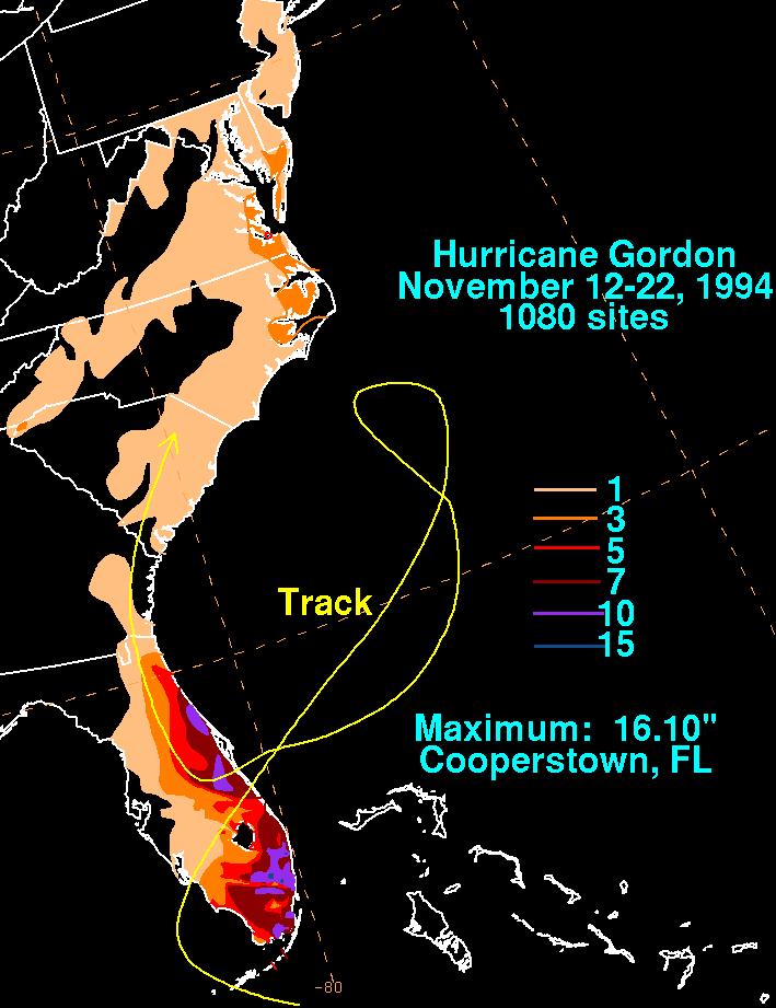
Florida's physical geography was also damaged by the storm. Gordon caused significant beach erosion along portions of Florida east coast and destroyed $275 million (1994 dollars) of crops and farmland.
.
Sustained winds in the Hatteras, North Carolina
area peaked at 50 mph (80.5 km/h) in Buxton
. The hurricane produced tides of 2.7 ft (0.82296 m) above normal in Frisco
. High waves and tides closed several portions of North Carolina Highway 12 for up to four days, and also resulted in significant beach erosion along the Outer Banks. North of Hatteras Village, the high waves washed out 225 ft (68.6 m) of dunes. The effects were similar to that of the 1991 Perfect Storm, although damage was lighter during Gordon. The hurricane destroyed five homes in Kitty Hawk
, along with 52 houses and 2 businesses that were damaged. In Rodanthe
, two homes sustained water damage. The cost of the storm was estimated at $314,000. Effects further south in North Carolina were lesser, although serious beach erosion was reported. Offshore, a family of four required rescue from the Coast Guard
after their boat began filling with water in the midst of 17 ft (5.2 m) surf.
Further north, the interaction between Gordon and a ridge over New England produced coastal flooding in eastern Virginia. Tides reached 4 ft (1.2 m) above normal in Virginia Beach
, which washed away 100 ft (30.5 m) of a fishing pier. The high tides caused road damage and minor housing damage.
issued an official statement crediting Jamaica and Cuba's warning infrastructure for the low loss of life there, and blaming Haiti's lack of such a system for the large number of deaths there.
Despite the devastation in Haiti and the extensive damage in Cuba and Florida, Gordon was not retired by the World Meteorological Organization in the spring of 1995. Member nations of the World Meteorological Organization
must send a delegate to the annual meeting to formally submit a request for tropical cyclone name retirement; for unknown reasons, Haiti did not send a delegate to the Spring 1995 meeting. As a result, Gordon was one of few tropical cyclones that did not have its name retired despite its catastrophic effects. The name Gordon was used for the first time in 1994, replacing Gilbert
from the 1988 Atlantic hurricane season
.
1994 Atlantic hurricane season
The 1994 Atlantic hurricane seasonofficially began June 1, 1994, and officially ended November 30, 1994. These dates conventionally delimit the period of each year when most tropical cyclones form in the Atlantic basin....
. The twelfth and final tropical cyclone of the season, Gordon formed in the southwestern Caribbean
Caribbean
The Caribbean is a crescent-shaped group of islands more than 2,000 miles long separating the Gulf of Mexico and the Caribbean Sea, to the west and south, from the Atlantic Ocean, to the east and north...
on November 8 after two tropical waves enhanced convection around in area of disturbed weather. Without strengthening, the storm made landfall Puerto Cabezas
Puerto Cabezas
Puerto Cabezas is a municipality in, and capital of, the North Atlantic Coast department of Nicaragua....
, Nicaragua
Nicaragua
Nicaragua is the largest country in the Central American American isthmus, bordered by Honduras to the north and Costa Rica to the south. The country is situated between 11 and 14 degrees north of the Equator in the Northern Hemisphere, which places it entirely within the tropics. The Pacific Ocean...
. Later on November 10, the storm began to strengthen as it tracked further from land, it almost immediately strengthened into Tropical Storm Gordon, the seventh named named storm
Tropical cyclone
A tropical cyclone is a storm system characterized by a large low-pressure center and numerous thunderstorms that produce strong winds and heavy rain. Tropical cyclones strengthen when water evaporated from the ocean is released as the saturated air rises, resulting in condensation of water vapor...
that season. and the third hurricane of the 1994 Atlantic hurricane season
1994 Atlantic hurricane season
The 1994 Atlantic hurricane seasonofficially began June 1, 1994, and officially ended November 30, 1994. These dates conventionally delimit the period of each year when most tropical cyclones form in the Atlantic basin....
. Gordon also made landfalls in Jamaica
Jamaica
Jamaica is an island nation of the Greater Antilles, in length, up to in width and 10,990 square kilometres in area. It is situated in the Caribbean Sea, about south of Cuba, and west of Hispaniola, the island harbouring the nation-states Haiti and the Dominican Republic...
and Cuba
Cuba
The Republic of Cuba is an island nation in the Caribbean. The nation of Cuba consists of the main island of Cuba, the Isla de la Juventud, and several archipelagos. Havana is the largest city in Cuba and the country's capital. Santiago de Cuba is the second largest city...
while a minimal tropical storm.
Following a winding path, it crossed Cuba, entering into the southwestern Atlantic, although it resembled a subtropical cyclone
Subtropical cyclone
A subtropical cyclone is a weather system that has some characteristics of a tropical and an extratropical cyclone. As early as the 1950s, meteorologists were unclear whether they should be characterized as tropical or extratropical cyclones. They were officially recognized by the National...
. By the time it entered the Gulf of Mexico
Gulf of Mexico
The Gulf of Mexico is a partially landlocked ocean basin largely surrounded by the North American continent and the island of Cuba. It is bounded on the northeast, north and northwest by the Gulf Coast of the United States, on the southwest and south by Mexico, and on the southeast by Cuba. In...
it was a fully tropical cyclone again. Tropical Storm Gordon then headed north-northwestward and paralleled the coast of Cuba. Gordon later cross the Florida Keys
Florida Keys
The Florida Keys are a coral archipelago in southeast United States. They begin at the southeastern tip of the Florida peninsula, about south of Miami, and extend in a gentle arc south-southwest and then westward to Key West, the westernmost of the inhabited islands, and on to the uninhabited Dry...
and also made landfall in Fort Myers, Florida
Fort Myers, Florida
Fort Myers is the county seat and commercial center of Lee County, Florida, United States. Its population was 62,298 in the 2010 census, a 29.23 percent increase over the 2000 figure....
while still a weak tropical storm. Gordon began to strengthen further as it crossed Florida and entered the Atlantic Ocean. It had reached hurricane status for several hours on November 17 and 18 before weakening back and again heading for Florida. The storm quickly weakened and was only a tropical depression when it made a third landfall in Florida on November 20. Tropical Depression Gordon accelerated generally northward and dissipated by the next day over South Carolina
South Carolina
South Carolina is a state in the Deep South of the United States that borders Georgia to the south, North Carolina to the north, and the Atlantic Ocean to the east. Originally part of the Province of Carolina, the Province of South Carolina was one of the 13 colonies that declared independence...
.
Gordon was a catastrophic storm in Haiti
Haiti
Haiti , officially the Republic of Haiti , is a Caribbean country. It occupies the western, smaller portion of the island of Hispaniola, in the Greater Antillean archipelago, which it shares with the Dominican Republic. Ayiti was the indigenous Taíno or Amerindian name for the island...
, killing an estimated 1,122 people. In addition, Gordon also left 514 million (1994 USD, $ USD) when it passed through Cuba, Jamaica, Florida, and offshore of North Carolina
North Carolina
North Carolina is a state located in the southeastern United States. The state borders South Carolina and Georgia to the south, Tennessee to the west and Virginia to the north. North Carolina contains 100 counties. Its capital is Raleigh, and its largest city is Charlotte...
. Despite the high death toll and the damage, the name Gordon was not retired following the season.
Meteorological history
Widespread convectionConvection
Convection is the movement of molecules within fluids and rheids. It cannot take place in solids, since neither bulk current flows nor significant diffusion can take place in solids....
persisted in the southwestern Caribbean Sea
Caribbean Sea
The Caribbean Sea is a sea of the Atlantic Ocean located in the tropics of the Western hemisphere. It is bounded by Mexico and Central America to the west and southwest, to the north by the Greater Antilles, and to the east by the Lesser Antilles....
during early November, which was enhanced by the passage of two tropical wave
Tropical wave
Tropical waves, easterly waves, or tropical easterly waves, also known as African easterly waves in the Atlantic region, are a type of atmospheric trough, an elongated area of relatively low air pressure, oriented north to south, which move from east to west across the tropics causing areas of...
s passing through the area. The second produced a low-level circulation just north of Panama
Panama
Panama , officially the Republic of Panama , is the southernmost country of Central America. Situated on the isthmus connecting North and South America, it is bordered by Costa Rica to the northwest, Colombia to the southeast, the Caribbean Sea to the north and the Pacific Ocean to the south. The...
early on November 6. Convection slowly organized as it drifted northwestward, and by 1200 UTC
Coordinated Universal Time
Coordinated Universal Time is the primary time standard by which the world regulates clocks and time. It is one of several closely related successors to Greenwich Mean Time. Computer servers, online services and other entities that rely on having a universally accepted time use UTC for that purpose...
on November 7 the circulation displayed enough curvature to warrant initiating Dvorak technique
Dvorak technique
The Dvorak technique is a widely used system to subjectively estimate tropical cyclone intensity based solely on visible and infrared satellite images. Several agencies issue Dvorak intensity numbers for cyclones of sufficient intensity...
estimates. Late the next day, convection became more concentrated, and based on surface observations and satellite estimates the National Hurricane Center
National Hurricane Center
The National Hurricane Center , located at Florida International University in Miami, Florida, is the division of the National Weather Service responsible for tracking and predicting weather systems within the tropics between the Prime Meridian and the 140th meridian west poleward to the 30th...
estimates the system developed into Tropical Depression Twelve midday on November 8 while located a short distance off the southeast coast of Nicaragua
Nicaragua
Nicaragua is the largest country in the Central American American isthmus, bordered by Honduras to the north and Costa Rica to the south. The country is situated between 11 and 14 degrees north of the Equator in the Northern Hemisphere, which places it entirely within the tropics. The Pacific Ocean...
.
The depression continued drifting northwestward, and initially limited upper-level outflow
Outflow (meteorology)
Outflow, in meteorology, is air that flows outwards from a storm system. It is associated with ridging, or anticyclonic flow. In the low levels of the troposphere, outflow radiates from thunderstorms in the form of a wedge of rain-cooled air, which is visible as a thin rope-like cloud on weather...
led to very slow organization. Its environment became more favorable, and by November 9 the system maintained banding features and increasingly defined outflow. Proximity to land prevented strengthening, and early on November 10 it made landfall
Landfall (meteorology)
Landfall is the event of a tropical cyclone or a waterspout coming onto land after being over water. When a waterspout makes landfall it is reclassified as a tornado, which can then cause damage inland...
near Puerto Cabezas
Puerto Cabezas
Puerto Cabezas is a municipality in, and capital of, the North Atlantic Coast department of Nicaragua....
, Nicaragua. Shortly thereafter, an upper-level trough
Trough (meteorology)
A trough is an elongated region of relatively low atmospheric pressure, often associated with fronts.Unlike fronts, there is not a universal symbol for a trough on a weather chart. The weather charts in some countries or regions mark troughs by a line. In the United States, a trough may be marked...
turned the depression to the northeast, and the depression intensified into Tropical Storm Gordon after reaching open waters. Tracking slowly north-northeastward, the circulation of the cyclone was initially very broad, covering much of the western Caribbean Sea, and its combination with southwesterly vertical wind shear
Wind shear
Wind shear, sometimes referred to as windshear or wind gradient, is a difference in wind speed and direction over a relatively short distance in the atmosphere...
prevented significant strengthening. By November 12, the center was exposed due to the shear, though by later in the day the circulation became situated along the western edge of the deep convection. Early on November 13, Gordon struck Jamaica
Jamaica
Jamaica is an island nation of the Greater Antilles, in length, up to in width and 10,990 square kilometres in area. It is situated in the Caribbean Sea, about south of Cuba, and west of Hispaniola, the island harbouring the nation-states Haiti and the Dominican Republic...
near Kingston
Kingston, Jamaica
Kingston is the capital and largest city of Jamaica, located on the southeastern coast of the island. It faces a natural harbour protected by the Palisadoes, a long sand spit which connects the town of Port Royal and the Norman Manley International Airport to the rest of the island...
as a minimal tropical storm, and accelerating northeastward the cyclone made landfall near Guantánamo Bay, Cuba
Cuba
The Republic of Cuba is an island nation in the Caribbean. The nation of Cuba consists of the main island of Cuba, the Isla de la Juventud, and several archipelagos. Havana is the largest city in Cuba and the country's capital. Santiago de Cuba is the second largest city...
later that day.
Around the time of Gordon crossing Jamaica, an upper-level trough
Trough (meteorology)
A trough is an elongated region of relatively low atmospheric pressure, often associated with fronts.Unlike fronts, there is not a universal symbol for a trough on a weather chart. The weather charts in some countries or regions mark troughs by a line. In the United States, a trough may be marked...
spawned a low-level disturbance over the central Bahamas. From surface synoptic reports, the National Hurricane Center estimates Tropical Storm Gordon rapidly crossed Cuba and became the dominant system between Cuba and the Bahamas. However, other meteorologists believe Gordon dissipated after hitting Cuba, and that a second cyclone became the dominant system. A deep-layer ridge
Ridge (meteorology)
A ridge is an elongated region of relatively high atmospheric pressure, the opposite of a trough....
turned the storm to the west-northwest, and by November 14 the cloud pattern and surface wind field of Gordon resembled that of a subtropical cyclone, with little convection near and the strongest winds well-removed from the center. The storm paralleled the northern coast of Cuba, and Radiosonde
Radiosonde
A radiosonde is a unit for use in weather balloons that measures various atmospheric parameters and transmits them to a fixed receiver. Radiosondes may operate at a radio frequency of 403 MHz or 1680 MHz and both types may be adjusted slightly higher or lower as required...
indicated a largely cold-core system
Cold-core low
A cold-core low, also known as a cold low or cold-core cyclone, is a cyclone aloft which has an associated cold pool of air residing at high altitude within the Earth's troposphere. It is a low pressure system which strengthens with height in accordance with the thermal wind relationship. These...
, with the exception of a mid-level warm air in its eastern semicircle. Early on November 15, Gordon began to re-acquire tropical characteristics, with a warm-core center re-developing near an area of deep convection. Later that day, the broad center crossed the Florida Keys
Florida Keys
The Florida Keys are a coral archipelago in southeast United States. They begin at the southeastern tip of the Florida peninsula, about south of Miami, and extend in a gentle arc south-southwest and then westward to Key West, the westernmost of the inhabited islands, and on to the uninhabited Dry...
near Key West
Key West, Florida
Key West is a city in Monroe County, Florida, United States. The city encompasses the island of Key West, the part of Stock Island north of U.S. 1 , Sigsbee Park , Fleming Key , and Sunset Key...
. Deep convection continued to build and concentrate over the center, and the wind field contracted as it transitioned into a fully tropical cyclone over the southeastern Gulf of Mexico
Gulf of Mexico
The Gulf of Mexico is a partially landlocked ocean basin largely surrounded by the North American continent and the island of Cuba. It is bounded on the northeast, north and northwest by the Gulf Coast of the United States, on the southwest and south by Mexico, and on the southeast by Cuba. In...
. Under the influence of an approaching mid- to upper-level trough, Gordon turned to the northeast and made landfall near Fort Myers, Florida
Fort Myers, Florida
Fort Myers is the county seat and commercial center of Lee County, Florida, United States. Its population was 62,298 in the 2010 census, a 29.23 percent increase over the 2000 figure....
on November 16 with winds of 50 mph (85 km/h).
Atlantic Ocean
The Atlantic Ocean is the second-largest of the world's oceanic divisions. With a total area of about , it covers approximately 20% of the Earth's surface and about 26% of its water surface area...
near Vero Beach
Vero Beach, Florida
Vero Beach is a city in Indian River County, Florida, USA. According to the U.S. Census Bureau's 2006 estimates, the city had a population of 16,939. It is the county seat of Indian River County...
. As it reached the Gulf Stream
Gulf Stream
The Gulf Stream, together with its northern extension towards Europe, the North Atlantic Drift, is a powerful, warm, and swift Atlantic ocean current that originates at the tip of Florida, and follows the eastern coastlines of the United States and Newfoundland before crossing the Atlantic Ocean...
, a small but intense area of convection developed over the center, with winds increasing to 65 mph (105 km/h). On November 17 the thunderstorm activity was impacted by wind shear, which was expected to prevent further strengthening. However, Hurricane Hunters
Hurricane Hunters
The Hurricane Hunters are aircraft that fly into tropical cyclones in the North Atlantic Ocean and Northeastern Pacific Ocean for the specific purpose of directly measuring weather data in and around those storms. In the United States, the Air Force, Navy, and NOAA units have all participated in...
reported strong winds in excess of 90 mph (145 km/h) within the deep convection, and late on November 17 Gordon attained hurricane status while located about 245 miles (345 km) southeast of Cape Fear, North Carolina
North Carolina
North Carolina is a state located in the southeastern United States. The state borders South Carolina and Georgia to the south, Tennessee to the west and Virginia to the north. North Carolina contains 100 counties. Its capital is Raleigh, and its largest city is Charlotte...
; shortly thereafter the hurricane reached peak winds of 85 mph (140 km/h). Upon attaining hurricane status, the trough that had turned Gordon to the north surpassed the cyclone, resulting in the development of a mid-level ridge to its north. The ridge turned the hurricane sharply northwestward, and at the time Gordon was expected to cross the Outer Banks
Outer Banks
The Outer Banks is a 200-mile long string of narrow barrier islands off the coast of North Carolina, beginning in the southeastern corner of Virginia Beach on the east coast of the United States....
as a minimal hurricane. After passing about 90 miles (140 km) south of Cape Hatteras, Gordon turned to the south and south-southeast and weakened to a tropical storm. Encountering northwesterly wind shear and cooler, drier air, the cyclone steadily weakened as it lost much of its deep convection. On November 19, the storm turned to the southwest, and the next day Gordon deteriorated to tropical depression status as it curved westward. Early on November 20 Gordon moved ashore near Cape Canaveral, Florida
Cape Canaveral, Florida
Cape Canaveral is a city in Brevard County, Florida, United States. The population was 8,829 at the 2000 census. As of 2008, the estimated population according to the U.S. Census Bureau was 10,147...
as a minimal tropical cyclone; it turned northward into Georgia
Georgia (U.S. state)
Georgia is a state located in the southeastern United States. It was established in 1732, the last of the original Thirteen Colonies. The state is named after King George II of Great Britain. Georgia was the fourth state to ratify the United States Constitution, on January 2, 1788...
, and on November 21 Gordon dissipated over South Carolina
South Carolina
South Carolina is a state in the Deep South of the United States that borders Georgia to the south, North Carolina to the north, and the Atlantic Ocean to the east. Originally part of the Province of Carolina, the Province of South Carolina was one of the 13 colonies that declared independence...
.
Impact
| Region | Deaths | Damage |
|---|---|---|
| Costa Rica Costa Rica Costa Rica , officially the Republic of Costa Rica is a multilingual, multiethnic and multicultural country in Central America, bordered by Nicaragua to the north, Panama to the southeast, the Pacific Ocean to the west and the Caribbean Sea to the east.... |
6 | Unknown |
| Jamaica Jamaica Jamaica is an island nation of the Greater Antilles, in length, up to in width and 10,990 square kilometres in area. It is situated in the Caribbean Sea, about south of Cuba, and west of Hispaniola, the island harbouring the nation-states Haiti and the Dominican Republic... |
4 | $11.8 million |
| Cuba Cuba The Republic of Cuba is an island nation in the Caribbean. The nation of Cuba consists of the main island of Cuba, the Isla de la Juventud, and several archipelagos. Havana is the largest city in Cuba and the country's capital. Santiago de Cuba is the second largest city... |
2 | $102 million |
| Haiti Haiti Haiti , officially the Republic of Haiti , is a Caribbean country. It occupies the western, smaller portion of the island of Hispaniola, in the Greater Antillean archipelago, which it shares with the Dominican Republic. Ayiti was the indigenous Taíno or Amerindian name for the island... |
1,122 | Unknown |
| Dominican Republic Dominican Republic The Dominican Republic is a nation on the island of La Hispaniola, part of the Greater Antilles archipelago in the Caribbean region. The western third of the island is occupied by the nation of Haiti, making Hispaniola one of two Caribbean islands that are shared by two countries... |
5 | Unknown |
| Florida Florida Florida is a state in the southeastern United States, located on the nation's Atlantic and Gulf coasts. It is bordered to the west by the Gulf of Mexico, to the north by Alabama and Georgia and to the east by the Atlantic Ocean. With a population of 18,801,310 as measured by the 2010 census, it... |
8 | $400 million |
| North Carolina North Carolina North Carolina is a state located in the southeastern United States. The state borders South Carolina and Georgia to the south, Tennessee to the west and Virginia to the north. North Carolina contains 100 counties. Its capital is Raleigh, and its largest city is Charlotte... |
0 | $500,000 |
| Total | 1,147 | $514 million |
Although Gordon was a tropical storm for most of its existence, it caused enormous damage and loss of life. The United Nations
United Nations
The United Nations is an international organization whose stated aims are facilitating cooperation in international law, international security, economic development, social progress, human rights, and achievement of world peace...
estimated death toll in Haiti
Haiti
Haiti , officially the Republic of Haiti , is a Caribbean country. It occupies the western, smaller portion of the island of Hispaniola, in the Greater Antillean archipelago, which it shares with the Dominican Republic. Ayiti was the indigenous Taíno or Amerindian name for the island...
was 1,122. Six deaths were reported in Costa Rica
Costa Rica
Costa Rica , officially the Republic of Costa Rica is a multilingual, multiethnic and multicultural country in Central America, bordered by Nicaragua to the north, Panama to the southeast, the Pacific Ocean to the west and the Caribbean Sea to the east....
, five in the Dominican Republic
Dominican Republic
The Dominican Republic is a nation on the island of La Hispaniola, part of the Greater Antilles archipelago in the Caribbean region. The western third of the island is occupied by the nation of Haiti, making Hispaniola one of two Caribbean islands that are shared by two countries...
, two in Jamaica
Jamaica
Jamaica is an island nation of the Greater Antilles, in length, up to in width and 10,990 square kilometres in area. It is situated in the Caribbean Sea, about south of Cuba, and west of Hispaniola, the island harbouring the nation-states Haiti and the Dominican Republic...
, two in Cuba
Cuba
The Republic of Cuba is an island nation in the Caribbean. The nation of Cuba consists of the main island of Cuba, the Isla de la Juventud, and several archipelagos. Havana is the largest city in Cuba and the country's capital. Santiago de Cuba is the second largest city...
, and eight in Florida
Florida
Florida is a state in the southeastern United States, located on the nation's Atlantic and Gulf coasts. It is bordered to the west by the Gulf of Mexico, to the north by Alabama and Georgia and to the east by the Atlantic Ocean. With a population of 18,801,310 as measured by the 2010 census, it...
. Property damage to the United States
United States
The United States of America is a federal constitutional republic comprising fifty states and a federal district...
was estimated at $400 million (1994 dollars). Property damage statistics for the other affected areas are not available, but were reportedly severe in both Haiti
Haiti
Haiti , officially the Republic of Haiti , is a Caribbean country. It occupies the western, smaller portion of the island of Hispaniola, in the Greater Antillean archipelago, which it shares with the Dominican Republic. Ayiti was the indigenous Taíno or Amerindian name for the island...
and Cuba
Cuba
The Republic of Cuba is an island nation in the Caribbean. The nation of Cuba consists of the main island of Cuba, the Isla de la Juventud, and several archipelagos. Havana is the largest city in Cuba and the country's capital. Santiago de Cuba is the second largest city...
.
Jamaica
While passing south of Jamaica, Gordon resulted in about $11.8 million in damage, mostly in Clarendon Parish. About half of the overall damage was from roads, although an additional quarter was due to crop damage. There were four deaths and two injuries in the country.Haiti
Haiti
Haiti , officially the Republic of Haiti , is a Caribbean country. It occupies the western, smaller portion of the island of Hispaniola, in the Greater Antillean archipelago, which it shares with the Dominican Republic. Ayiti was the indigenous Taíno or Amerindian name for the island...
suffers large death tolls from many hurricanes, and was especially devastated by Hurricane Gordon—the storm killed 1,122 in the impoverished nation in 1994 although estimates range as high as 2,200. It has been argued that the damage caused by the storm, among many other storms, are in part human-caused disasters. Massive deforestation
Deforestation
Deforestation is the removal of a forest or stand of trees where the land is thereafter converted to a nonforest use. Examples of deforestation include conversion of forestland to farms, ranches, or urban use....
has left Haiti with about 1.4% of its forest
Forest
A forest, also referred to as a wood or the woods, is an area with a high density of trees. As with cities, depending where you are in the world, what is considered a forest may vary significantly in size and have various classification according to how and what of the forest is composed...
s as of 2004, leaving denuded
Denudation
In geology, denudation is the long-term sum of processes that cause the wearing away of the earth’s surface leading to a reduction in elevation and relief of landforms and landscapes...
mountain
Mountain
Image:Himalaya_annotated.jpg|thumb|right|The Himalayan mountain range with Mount Everestrect 58 14 160 49 Chomo Lonzorect 200 28 335 52 Makalurect 378 24 566 45 Mount Everestrect 188 581 920 656 Tibetan Plateaurect 250 406 340 427 Rong River...
slopes that rainwater washes down unimpeded. The lack of tree cover contributed to the devastating flood
Flood
A flood is an overflow of an expanse of water that submerges land. The EU Floods directive defines a flood as a temporary covering by water of land not normally covered by water...
s that caused a majority of the deaths resulting from Hurricane Gordon.
Florida
Between Hurricane Gordon's three Florida landfalls it disrupted power to 425,000 customers. During its second landfall it ran a 505 ft (154 m) cargo ship aground less than 148 ft (45 m) from the Ft. Lauderdale beach. The storm's second landfall also spawned six tornadoTornado
A tornado is a violent, dangerous, rotating column of air that is in contact with both the surface of the earth and a cumulonimbus cloud or, in rare cases, the base of a cumulus cloud. They are often referred to as a twister or a cyclone, although the word cyclone is used in meteorology in a wider...
es. Four of the tornadoes did no damage and were rated F0 on the Fujita scale
Fujita scale
The Fujita scale , or Fujita-Pearson scale, is a scale for rating tornado intensity, based primarily on the damage tornadoes inflict on human-built structures and vegetation...
, but two were rated F1, and one was given an F2 rating. One of the F1 tornadoes occurred in Lake Worth where it uprooted several trees and damaged two businesses and 39 homes. The F2 tornado occurred closer to the landfall in Brevard County
Brevard County, Florida
Brevard County is a county located in the U.S. state of Florida, along the coast of the Atlantic Ocean. As of 2007 U.S. Census Bureau estimates, the population is 536,521, making it the 10th most populous county in the state. Influenced by the presence of the John F. Kennedy Space Center, Brevard...
where it destroyed 62 mobile homes and damaged 229 more in the Snug Harbor/Barefoot Bay mobile home communities.
Florida's physical geography was also damaged by the storm. Gordon caused significant beach erosion along portions of Florida east coast and destroyed $275 million (1994 dollars) of crops and farmland.
Remainder of United States
After affecting Florida, Gordon produced rainfall along much of the eastern United States, extending as far north as New Jersey. In North Carolina, rainfall peaked at 4.96 in (126 mm) in New Holland, and in Virginia the highest rainfall total was 5.25 in (133.4 mm) near NorfolkNorfolk, Virginia
Norfolk is an independent city in the Commonwealth of Virginia in the United States. With a population of 242,803 as of the 2010 Census, it is Virginia's second-largest city behind neighboring Virginia Beach....
.
Sustained winds in the Hatteras, North Carolina
Hatteras, North Carolina
Hatteras is an unincorporated community in Dare County, North Carolina, United States, on the Outer Banks island of Hatteras. North Carolina Highway 12 passes through the community linking it to Frisco and Ocracoke . It is south of the famous Cape Hatteras and the Cape Hatteras Lighthouse in Buxton...
area peaked at 50 mph (80.5 km/h) in Buxton
Buxton, North Carolina
Buxton is an unincorporated community of nearly 1,500 people on Hatteras Island near Cape Hatteras. It is located in Dare County in the U.S. state of North Carolina. North Carolina Highway 12 links the community to other Outer Banks communities such as Avon, Frisco, and Hatteras...
. The hurricane produced tides of 2.7 ft (0.82296 m) above normal in Frisco
Frisco, North Carolina
Frisco is a small unincorporated community on the barrier island of Hatteras Island, between the villages of Buxton and Hatteras. It is located in Dare County, North Carolina, USA, and was previously named Trent, or Trent Woods, but received a new name with the coming of the post office in 1898...
. High waves and tides closed several portions of North Carolina Highway 12 for up to four days, and also resulted in significant beach erosion along the Outer Banks. North of Hatteras Village, the high waves washed out 225 ft (68.6 m) of dunes. The effects were similar to that of the 1991 Perfect Storm, although damage was lighter during Gordon. The hurricane destroyed five homes in Kitty Hawk
Kitty Hawk, North Carolina
Kitty Hawk is a town in Dare County, North Carolina, United States. The population was 3,000 at the 2000 census. It was established in the early 18th century as Chickahawk....
, along with 52 houses and 2 businesses that were damaged. In Rodanthe
Rodanthe, North Carolina
Rodanthe is an unincorporated community located in Dare County, North Carolina, on Hatteras Island, part of North Carolina's Outer Banks. Rodanthe, along with Waves and Salvo, are part of the settlement of Chicamacomico...
, two homes sustained water damage. The cost of the storm was estimated at $314,000. Effects further south in North Carolina were lesser, although serious beach erosion was reported. Offshore, a family of four required rescue from the Coast Guard
United States Coast Guard
The United States Coast Guard is a branch of the United States Armed Forces and one of the seven U.S. uniformed services. The Coast Guard is a maritime, military, multi-mission service unique among the military branches for having a maritime law enforcement mission and a federal regulatory agency...
after their boat began filling with water in the midst of 17 ft (5.2 m) surf.
Further north, the interaction between Gordon and a ridge over New England produced coastal flooding in eastern Virginia. Tides reached 4 ft (1.2 m) above normal in Virginia Beach
Virginia Beach, Virginia
Virginia Beach is an independent city located in the Hampton Roads metropolitan area of Virginia, on the Atlantic Ocean at the mouth of the Chesapeake Bay...
, which washed away 100 ft (30.5 m) of a fishing pier. The high tides caused road damage and minor housing damage.
Aftermath and lack of retirement
After the passage of Gordon, the World Meteorological OrganizationWorld Meteorological Organization
The World Meteorological Organization is an intergovernmental organization with a membership of 189 Member States and Territories. It originated from the International Meteorological Organization , which was founded in 1873...
issued an official statement crediting Jamaica and Cuba's warning infrastructure for the low loss of life there, and blaming Haiti's lack of such a system for the large number of deaths there.
Despite the devastation in Haiti and the extensive damage in Cuba and Florida, Gordon was not retired by the World Meteorological Organization in the spring of 1995. Member nations of the World Meteorological Organization
World Meteorological Organization
The World Meteorological Organization is an intergovernmental organization with a membership of 189 Member States and Territories. It originated from the International Meteorological Organization , which was founded in 1873...
must send a delegate to the annual meeting to formally submit a request for tropical cyclone name retirement; for unknown reasons, Haiti did not send a delegate to the Spring 1995 meeting. As a result, Gordon was one of few tropical cyclones that did not have its name retired despite its catastrophic effects. The name Gordon was used for the first time in 1994, replacing Gilbert
Hurricane Gilbert
Hurricane Gilbert was an extremely powerful Cape Verde-type hurricane that formed during the 1988 Atlantic hurricane season and created widespread destruction in the Caribbean Sea and the Gulf of Mexico. It is the second most intense hurricane ever observed in the Atlantic basin behind only...
from the 1988 Atlantic hurricane season
1988 Atlantic hurricane season
The 1988 Atlantic hurricane season was a moderately active season that proved costly and deadly, with 15 tropical cyclones directly affecting land. The season officially began on June 1, 1988, and lasted until November 30, 1988, although activity began on May 30 when a tropical...
.
See also
- Other storms of the same name
- Geography of Haiti
- Economy of HaitiEconomy of HaitiHaiti is the poorest country in the Americas. Two-thirds of all Haitians depend on the agriculture sector, mainly small-scale subsistence farming, and remain vulnerable to damage from frequent natural disasters, exacerbated by the country's widespread deforestation...
- Timeline of the 1994 Atlantic hurricane seasonTimeline of the 1994 Atlantic hurricane seasonThe 1994 Atlantic hurricane season was a below-average Atlantic hurricane season that produced seven named tropical cyclones. The season officially began on June 1 and ended on November 30, dates which conventionally limit the period of each year when tropical cyclones tend to form in the Atlantic....
- List of North Carolina hurricanes (1980–present)