
.gif)
Tropical Storm Keith (1988)
Encyclopedia
Tropical Storm Keith was the latest Atlantic
tropical cyclone
in the calendar year to strike the Continental United States since the 1925 Atlantic hurricane season
. The eleventh tropical storm of the 1988 Atlantic hurricane season
, Keith developed out of a tropical wave
in the Caribbean Sea
on November 17. It tracked northwestward, and under generally favorable conditions, it reached a peak intensity of 70 mph (110 km/h) shortly before striking the northeastern tip of the Yucatán Peninsula
. It turned northeastward in the Gulf of Mexico
, and made landfall
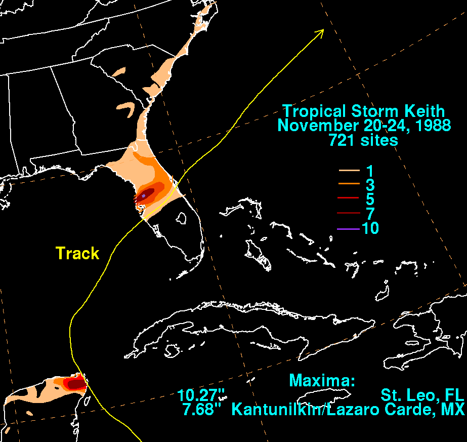
near Sarasota, Florida
, on November 23. Keith accelerated its forward motion under the influence of a cold front
, and became extratropical
near Bermuda on November 24. The extratropical remnant persisted for two more days.
Early in its duration, Keith produced moderate to heavy rainfall in Honduras, Jamaica, and Cuba. Minimal damage was reported in Mexico, which was still recovering from the effects of Hurricane Gilbert
two months prior. Keith, the last of four named tropical cyclones
to hit the United States during the season, produced moderate rainfall, rough storm surge, and gusty winds across central Florida. Overall damage was fairly minor but widespread, totaling $7.3 million (1988 USD; $ USD). Near the coast of Florida, damage occurred mainly from storm surge and beach erosion. Further inland there were floods, downed trees and power lines. No fatalities were reported.
moved off the coast of Africa on November 5. It tracked steadily westward across the tropical Atlantic Ocean and its forward motion slowed after it passed the Lesser Antilles
on November 12. A large and well-defined anticyclone
persisted across much of the Caribbean Sea
, providing a favorable environment for the system. A low-level circulation
gradually became evident on satellite imagery within the disturbance. Based on ship observations
, the National Hurricane Center
estimated the system organized into a tropical depression on November 17, located about 280 miles (450 km) south of the western tip of Haiti.
Initially, the depression was disorganized as it continued westward; on November 18 the center became exposed from the area of deep convection
. However, the upper-level environment gradually became more favorable for further development, and deep convection, or thunderstorm activity, developed closer to the center. An eastward-moving upper-level trough
in the Gulf of Mexico
caused the depression to turn northwest. The next day, the depression intensified into a tropical storm while located a short distance north of Honduras, receiving the name Keith
. It quickly intensified, and on November 21 the storm attained its peak strength of 985 mbar
(29.09 inHg
) with winds of 70 mph (110 km/h). The trough, which turned Keith northwestward, rapidly accelerated northeastward; as a result, the storm to move slowly to the northwest until making landfall
on the northeastern tip of the Yucatán Peninsula
at 0800 UTC on November 21, at an intensity slightly below hurricane status.
After briefly moving over land, Keith turned northward under the influence of a trailing frontal trough
. The storm became disorganized while recurving towards the northeast because of increased vertical wind shear
and the presence of cool, dry air from its north. On November 23, Keith made landfall near Sarasota, Florida
with winds of 65 mph (100 km/h), while most of its convection was located well to the north of the center. Its landfall was the second latest on record for the Continental United States, only behind a hurricane in the 1925 season
. The storm quickly weakened as it crossed the state, and within hours the winds dropped to 40 mph (65 km/h). Reaching the Atlantic Ocean eight hours after moving ashore, Keith began to gradually re-intensify, and under the influence of a very large upper-level low pressure area over Newfoundland, the storm accelerated northeastward. On November 24, the storm again reached its peak intensity of 70 mph (110 km/h), shortly before becoming an extratropical cyclone
near Bermuda. Keith restrengthened and deepened into a powerful extratropical cyclone, attaining hurricane force winds and a minimum pressure of 945 mbar (27.92 inHg). The extratropical storm turned westward and was last observed on November 26 to the northeast of Newfoundland.
.jpg) On November 20, shortly before the tropical depression intensified into a tropical storm, the government of Honduras issued a tropical storm warning
On November 20, shortly before the tropical depression intensified into a tropical storm, the government of Honduras issued a tropical storm warning
for the Swan Islands
, along with a tropical storm watch for the northwestern Honduran coastline. The advisories were discontinued within 10 hours of Keith's passage through the region. The government of Belize briefly declared a tropical storm watch for the entire coastline of the country, although when it became clear Keith posed little threat, the watch was canceled. About 16 hours before the storm made landfall on the Yucatán Peninsula
, the government of Mexico issued a tropical storm watch for much of the coastline of Quintana Roo
. Six hours later, a tropical storm warning replaced the watch, and it was extended westward to Progreso, Yucatán
; a hurricane watch was also posted. Cuban officials issued a bulletin on the night of November 20, advising that tropical storm conditions would spread over the western portion of the island. A subsequent bulletin indicated the possibility for hurricane conditions, although as the storm continued further to the northwest, the threat diminished.
Two days before the storm struck Florida, emergency management workers began working to prepare for its onslaught. The next day, the water levels in five lakes in Hillsborough County
were decreased as a precaution. Residents prepared sandbags to prevent flooding along coastal areas, while boat owners worked to secure their boats. Some tourists near the southwest Florida coast left for areas further inland, though many stayed despite the storm. Red Cross officials opened six emergency shelters. Additionally, police departments in Clearwater
, Indian Shores
, and Largo
expanded their workforce to handle storm-related problems. The storm resulted in the closure of some private schools as well as the Hillsborough Community College
. About 21 hours before Keith made its final landfall, the National Hurricane Center
issued a tropical storm warning along the Florida
west coast from Cape Sable
to Cedar Key
. The next day, a tropical storm warning was posted from Jupiter
northward to Savannah, Georgia
. A tropical storm warning was briefly issued for Bermuda, as well.
 Keith dropped around 3 inches (75 mm) of rainfall along the northern coast of Honduras, and totals of around 10 inches (250 mm) were reported on offshore islands. As the storm was making landfall on Mexico, a ship just west of Cozumel
reported wind gusts of 90 mph (149 km/h), while a second ship in Puerto Morelos
recorded sustained winds of 70 mph (110 km/h). Reports from Cozumel indicated torrential rainfall and a large number of lightning strikes during the period of highest winds. Rainfall peaked at 7.69 inches (195 mm) just south of Cancún
. Still recovering from the effects of Hurricane Gilbert
two months prior, the Yucatán Peninsula received only minor damage as a result of Keith. The storm triggered flooding in western Cuba that severely damaged tobacco and vegetable crops. Officials forced 2,500 residents to evacuate their homes due to the flooding. The storm also dropped nearly 4 inches (100 mm) of precipitation in Kingston, Jamaica
.
Off the coast of Florida, a freighter and its crew of ten were stranded after the storm flooded its engine room. The cyclone produced a moderately strong storm surge
in isolated locations along the southwest coast of Florida, peaking at 5.94 feet (1.81 m) at Bradenton
and Fort Myers Beach
. The combination of storm surge and waves severely eroded beaches along Charlotte Harbor
and Estero Bay
. In Naples
, strong waves destroyed the western end of the Naples Pier where several boats were washed ashore. Heavy precipitation fell to the north of the center, peaking at 10.27 inches (260 mm) in Saint Leo
. Sustained winds peaked at 63 mph (101 km/h) at the MacDill Air Force Base
, with stronger gusts. Inland from the immediate coastline, damage was mostly limited to isolated fresh-water flooding, downed trees, and power outages; overall damage was widespread but fairly light, and six structures were destroyed across the state. Before moving ashore, Keith spawned two tornado
es, one of which damaged approximately 30 mobile homes in Clermont
. In Lakeland
, a washed out track derailed a 34-car train, which broke a natural gas line and forced 450 people to evacuate. In Lee County
, damage totaled $1.5 million (1988 USD; $ USD), and in Pinellas County
the storm caused about $5.8 million in damage (1988 USD; $ USD).
A light storm surge of 1 to 2 feet (0.3 to 0.6 m) was reported along the northeast Florida coast into southeastern Georgia. The storm's outer rainband
s dropped light rainfall of around 1 inch (25 mm) across coastal Florida, northward to North Carolina. A station on Bermuda reported sustained winds of 47 mph (76 km/h), with gusts to 78 mph (126 km/h). Only light damage occurred on the island.
Atlantic hurricane
North Atlantic tropical cyclones usually form in the northern hemisphere summer or fall. Tropical cyclones can be categorized by intensity. Tropical storms have one-minute maximum sustained winds of at least 39 mph , while hurricanes have one-minute maximum sustained exceeding 74 mph...
tropical cyclone
Tropical cyclone
A tropical cyclone is a storm system characterized by a large low-pressure center and numerous thunderstorms that produce strong winds and heavy rain. Tropical cyclones strengthen when water evaporated from the ocean is released as the saturated air rises, resulting in condensation of water vapor...
in the calendar year to strike the Continental United States since the 1925 Atlantic hurricane season
1925 Atlantic hurricane season
The 1925 Atlantic hurricane season was an inactive Atlantic hurricane season during which four tropical cyclones, two of which were hurricanes, formed. The first storm developed on August 18, and the last dissipated on December 1. The season began at a late date, more than two months...
. The eleventh tropical storm of the 1988 Atlantic hurricane season
1988 Atlantic hurricane season
The 1988 Atlantic hurricane season was a moderately active season that proved costly and deadly, with 15 tropical cyclones directly affecting land. The season officially began on June 1, 1988, and lasted until November 30, 1988, although activity began on May 30 when a tropical...
, Keith developed out of a tropical wave
Tropical wave
Tropical waves, easterly waves, or tropical easterly waves, also known as African easterly waves in the Atlantic region, are a type of atmospheric trough, an elongated area of relatively low air pressure, oriented north to south, which move from east to west across the tropics causing areas of...
in the Caribbean Sea
Caribbean Sea
The Caribbean Sea is a sea of the Atlantic Ocean located in the tropics of the Western hemisphere. It is bounded by Mexico and Central America to the west and southwest, to the north by the Greater Antilles, and to the east by the Lesser Antilles....
on November 17. It tracked northwestward, and under generally favorable conditions, it reached a peak intensity of 70 mph (110 km/h) shortly before striking the northeastern tip of the Yucatán Peninsula
Yucatán Peninsula
The Yucatán Peninsula, in southeastern Mexico, separates the Caribbean Sea from the Gulf of Mexico, with the northern coastline on the Yucatán Channel...
. It turned northeastward in the Gulf of Mexico
Gulf of Mexico
The Gulf of Mexico is a partially landlocked ocean basin largely surrounded by the North American continent and the island of Cuba. It is bounded on the northeast, north and northwest by the Gulf Coast of the United States, on the southwest and south by Mexico, and on the southeast by Cuba. In...
, and made landfall
Landfall (meteorology)
Landfall is the event of a tropical cyclone or a waterspout coming onto land after being over water. When a waterspout makes landfall it is reclassified as a tornado, which can then cause damage inland...
near Sarasota, Florida
Sarasota, Florida
Sarasota is a city located in Sarasota County on the southwestern coast of the U.S. state of Florida. It is south of the Tampa Bay Area and north of Fort Myers...
, on November 23. Keith accelerated its forward motion under the influence of a cold front
Surface weather analysis
Surface weather analysis is a special type of weather map that provides a view of weather elements over a geographical area at a specified time based on information from ground-based weather stations...
, and became extratropical
Extratropical cyclone
Extratropical cyclones, sometimes called mid-latitude cyclones or wave cyclones, are a group of cyclones defined as synoptic scale low pressure weather systems that occur in the middle latitudes of the Earth having neither tropical nor polar characteristics, and are connected with fronts and...
near Bermuda on November 24. The extratropical remnant persisted for two more days.
Early in its duration, Keith produced moderate to heavy rainfall in Honduras, Jamaica, and Cuba. Minimal damage was reported in Mexico, which was still recovering from the effects of Hurricane Gilbert
Hurricane Gilbert
Hurricane Gilbert was an extremely powerful Cape Verde-type hurricane that formed during the 1988 Atlantic hurricane season and created widespread destruction in the Caribbean Sea and the Gulf of Mexico. It is the second most intense hurricane ever observed in the Atlantic basin behind only...
two months prior. Keith, the last of four named tropical cyclones
Atlantic hurricane
North Atlantic tropical cyclones usually form in the northern hemisphere summer or fall. Tropical cyclones can be categorized by intensity. Tropical storms have one-minute maximum sustained winds of at least 39 mph , while hurricanes have one-minute maximum sustained exceeding 74 mph...
to hit the United States during the season, produced moderate rainfall, rough storm surge, and gusty winds across central Florida. Overall damage was fairly minor but widespread, totaling $7.3 million (1988 USD; $ USD). Near the coast of Florida, damage occurred mainly from storm surge and beach erosion. Further inland there were floods, downed trees and power lines. No fatalities were reported.
Meteorological history
A tropical waveTropical wave
Tropical waves, easterly waves, or tropical easterly waves, also known as African easterly waves in the Atlantic region, are a type of atmospheric trough, an elongated area of relatively low air pressure, oriented north to south, which move from east to west across the tropics causing areas of...
moved off the coast of Africa on November 5. It tracked steadily westward across the tropical Atlantic Ocean and its forward motion slowed after it passed the Lesser Antilles
Lesser Antilles
The Lesser Antilles are a long, partly volcanic island arc in the Western Hemisphere. Most of its islands form the eastern boundary of the Caribbean Sea with the Atlantic Ocean, with the remainder located in the southern Caribbean just north of South America...
on November 12. A large and well-defined anticyclone
Anticyclone
An anticyclone is a weather phenomenon defined by the United States' National Weather Service's glossary as "[a] large-scale circulation of winds around a central region of high atmospheric pressure, clockwise in the Northern Hemisphere, counterclockwise in the Southern Hemisphere"...
persisted across much of the Caribbean Sea
Caribbean Sea
The Caribbean Sea is a sea of the Atlantic Ocean located in the tropics of the Western hemisphere. It is bounded by Mexico and Central America to the west and southwest, to the north by the Greater Antilles, and to the east by the Lesser Antilles....
, providing a favorable environment for the system. A low-level circulation
Atmospheric circulation
Atmospheric circulation is the large-scale movement of air, and the means by which thermal energy is distributed on the surface of the Earth....
gradually became evident on satellite imagery within the disturbance. Based on ship observations
Tropical cyclone observation
Tropical cyclone observation has been carried out over the past couple of centuries in various ways. The passage of typhoons, hurricanes, as well as other tropical cyclones have been detected by word of mouth from sailors recently coming to port or by radio transmissions from ships at sea, from...
, the National Hurricane Center
National Hurricane Center
The National Hurricane Center , located at Florida International University in Miami, Florida, is the division of the National Weather Service responsible for tracking and predicting weather systems within the tropics between the Prime Meridian and the 140th meridian west poleward to the 30th...
estimated the system organized into a tropical depression on November 17, located about 280 miles (450 km) south of the western tip of Haiti.
Initially, the depression was disorganized as it continued westward; on November 18 the center became exposed from the area of deep convection
Atmospheric convection
Atmospheric convection is the result of a parcel-environment instability, or temperature difference, layer in the atmosphere. Different lapse rates within dry and moist air lead to instability. Mixing of air during the day which expands the height of the planetary boundary layer leads to...
. However, the upper-level environment gradually became more favorable for further development, and deep convection, or thunderstorm activity, developed closer to the center. An eastward-moving upper-level trough
Trough (meteorology)
A trough is an elongated region of relatively low atmospheric pressure, often associated with fronts.Unlike fronts, there is not a universal symbol for a trough on a weather chart. The weather charts in some countries or regions mark troughs by a line. In the United States, a trough may be marked...
in the Gulf of Mexico
Gulf of Mexico
The Gulf of Mexico is a partially landlocked ocean basin largely surrounded by the North American continent and the island of Cuba. It is bounded on the northeast, north and northwest by the Gulf Coast of the United States, on the southwest and south by Mexico, and on the southeast by Cuba. In...
caused the depression to turn northwest. The next day, the depression intensified into a tropical storm while located a short distance north of Honduras, receiving the name Keith
Keith (given name)
Keith is a masculine given name. It comes from a Scottish surname, which is derived from a place name meaning "wood, forest". Keith was the 298th most common name given to newborn boys in the United States in 2007...
. It quickly intensified, and on November 21 the storm attained its peak strength of 985 mbar
Bar (unit)
The bar is a unit of pressure equal to 100 kilopascals, and roughly equal to the atmospheric pressure on Earth at sea level. Other units derived from the bar are the megabar , kilobar , decibar , centibar , and millibar...
(29.09 inHg
Inch of mercury
Inches of mercury, ' is a unit of measurement for pressure. It is still widely used for barometric pressure in weather reports, refrigeration and aviation in the United States, but is seldom used elsewhere....
) with winds of 70 mph (110 km/h). The trough, which turned Keith northwestward, rapidly accelerated northeastward; as a result, the storm to move slowly to the northwest until making landfall
Landfall (meteorology)
Landfall is the event of a tropical cyclone or a waterspout coming onto land after being over water. When a waterspout makes landfall it is reclassified as a tornado, which can then cause damage inland...
on the northeastern tip of the Yucatán Peninsula
Yucatán Peninsula
The Yucatán Peninsula, in southeastern Mexico, separates the Caribbean Sea from the Gulf of Mexico, with the northern coastline on the Yucatán Channel...
at 0800 UTC on November 21, at an intensity slightly below hurricane status.
After briefly moving over land, Keith turned northward under the influence of a trailing frontal trough
Weather front
A weather front is a boundary separating two masses of air of different densities, and is the principal cause of meteorological phenomena. In surface weather analyses, fronts are depicted using various colored lines and symbols, depending on the type of front...
. The storm became disorganized while recurving towards the northeast because of increased vertical wind shear
Wind shear
Wind shear, sometimes referred to as windshear or wind gradient, is a difference in wind speed and direction over a relatively short distance in the atmosphere...
and the presence of cool, dry air from its north. On November 23, Keith made landfall near Sarasota, Florida
Sarasota, Florida
Sarasota is a city located in Sarasota County on the southwestern coast of the U.S. state of Florida. It is south of the Tampa Bay Area and north of Fort Myers...
with winds of 65 mph (100 km/h), while most of its convection was located well to the north of the center. Its landfall was the second latest on record for the Continental United States, only behind a hurricane in the 1925 season
1925 Atlantic hurricane season
The 1925 Atlantic hurricane season was an inactive Atlantic hurricane season during which four tropical cyclones, two of which were hurricanes, formed. The first storm developed on August 18, and the last dissipated on December 1. The season began at a late date, more than two months...
. The storm quickly weakened as it crossed the state, and within hours the winds dropped to 40 mph (65 km/h). Reaching the Atlantic Ocean eight hours after moving ashore, Keith began to gradually re-intensify, and under the influence of a very large upper-level low pressure area over Newfoundland, the storm accelerated northeastward. On November 24, the storm again reached its peak intensity of 70 mph (110 km/h), shortly before becoming an extratropical cyclone
Extratropical cyclone
Extratropical cyclones, sometimes called mid-latitude cyclones or wave cyclones, are a group of cyclones defined as synoptic scale low pressure weather systems that occur in the middle latitudes of the Earth having neither tropical nor polar characteristics, and are connected with fronts and...
near Bermuda. Keith restrengthened and deepened into a powerful extratropical cyclone, attaining hurricane force winds and a minimum pressure of 945 mbar (27.92 inHg). The extratropical storm turned westward and was last observed on November 26 to the northeast of Newfoundland.
Preparations
Tropical cyclone warnings and watches
Warnings and watches are two levels of alert issued by national weather forecasting bodies to coastal areas threatened by the imminent approach of a tropical cyclone of tropical storm or hurricane intensity. They are notices to the local population and civil authorities to make appropriate...
for the Swan Islands
Swan Islands, Honduras
The Swan Islands, or Islas Santanilla, are a chain of three islands located in the northwestern Caribbean Sea, approximately ninety miles off the coastline of Honduras, with a land area of .-Detailed location and features:...
, along with a tropical storm watch for the northwestern Honduran coastline. The advisories were discontinued within 10 hours of Keith's passage through the region. The government of Belize briefly declared a tropical storm watch for the entire coastline of the country, although when it became clear Keith posed little threat, the watch was canceled. About 16 hours before the storm made landfall on the Yucatán Peninsula
Yucatán Peninsula
The Yucatán Peninsula, in southeastern Mexico, separates the Caribbean Sea from the Gulf of Mexico, with the northern coastline on the Yucatán Channel...
, the government of Mexico issued a tropical storm watch for much of the coastline of Quintana Roo
Quintana Roo
Quintana Roo officially Estado Libre y Soberano de Quintana Roo is one of the 31 states which, with the Federal District, comprise the 32 Federal Entities of Mexico. It is divided in 10 municipalities and its capital city is Chetumal....
. Six hours later, a tropical storm warning replaced the watch, and it was extended westward to Progreso, Yucatán
Progreso, Yucatán
Progreso is a port city in the Mexican state of Yucatán, located on the Gulf of Mexico in the north-west of the state some 30 minutes north of state capital Mérida by highway. As of the Mexican census of 2005, Progreso had an official population of 35,519 inhabitants, the fifth-largest community...
; a hurricane watch was also posted. Cuban officials issued a bulletin on the night of November 20, advising that tropical storm conditions would spread over the western portion of the island. A subsequent bulletin indicated the possibility for hurricane conditions, although as the storm continued further to the northwest, the threat diminished.
Two days before the storm struck Florida, emergency management workers began working to prepare for its onslaught. The next day, the water levels in five lakes in Hillsborough County
Hillsborough County, Florida
As of the census of 2000, there were 998,948 people, 391,357 households, and 255,164 families residing in the county. The population density was 951 people per square mile . There were 425,962 housing units at an average density of 405 per square mile...
were decreased as a precaution. Residents prepared sandbags to prevent flooding along coastal areas, while boat owners worked to secure their boats. Some tourists near the southwest Florida coast left for areas further inland, though many stayed despite the storm. Red Cross officials opened six emergency shelters. Additionally, police departments in Clearwater
Clearwater, Florida
Clearwater is a city located in Pinellas County, Florida, US, nearly due west of Tampa and northwest of St. Petersburg. In the west of Clearwater lies the Gulf of Mexico and in the east lies Tampa Bay. As of the 2000 census, the city had a total population of 108,787. It is the county seat of...
, Indian Shores
Indian Shores, Florida
Indian Shores is a town in Pinellas County, Florida, United States. The town is a beach-front community situated on a barrier island west of Seminole, Florida. The population was 1,705 at the 2000 census. As of 2004, the population estimated by the U.S. Census Bureau is 1,792....
, and Largo
Largo, Florida
Largo is the third largest city in Pinellas County, Florida, USA and is part of the Tampa Bay Area. Centrally located, it is the crossroads of the county. As of the 2000 census, the City had a total population of 69,371. As of 2004, the population estimated by the U.S. Census Bureau was...
expanded their workforce to handle storm-related problems. The storm resulted in the closure of some private schools as well as the Hillsborough Community College
Hillsborough Community College
Hillsborough Community College is a two-year community college, located in Hillsborough County, Florida. The college has six campuses located throughout the county. Locations include: Brandon, Dale Mabry, Plant City, Ybor City, MacDill AFB, and South Shore...
. About 21 hours before Keith made its final landfall, the National Hurricane Center
National Hurricane Center
The National Hurricane Center , located at Florida International University in Miami, Florida, is the division of the National Weather Service responsible for tracking and predicting weather systems within the tropics between the Prime Meridian and the 140th meridian west poleward to the 30th...
issued a tropical storm warning along the Florida
Florida
Florida is a state in the southeastern United States, located on the nation's Atlantic and Gulf coasts. It is bordered to the west by the Gulf of Mexico, to the north by Alabama and Georgia and to the east by the Atlantic Ocean. With a population of 18,801,310 as measured by the 2010 census, it...
west coast from Cape Sable
Cape Sable
Cape Sable, Florida is the southernmost point of the US mainland and mainland Florida. It is located in southwestern Florida, in Monroe County, and is part of the Everglades National Park. The cape is a peninsula issuing from the southeastern part of the Florida mainland, running west and curving...
to Cedar Key
Cedar Key, Florida
Cedar Key is a city in Levy County, Florida, United States. The population was 790 at the 2000 census. According to the U.S Census estimates of 2005, the city had a population of 958. The Cedar Keys are a cluster of islands close to the mainland. Most of the developed area of the city has been on...
. The next day, a tropical storm warning was posted from Jupiter
Jupiter, Florida
Jupiter is a town located in Palm Beach County, Florida. As of the 2000 census, the town had a total population of 39,328. The estimate population for 2009 is 50,606. As of 2006, the population had grown to 50,028, according to the University of Florida, Bureau of Economic and Business Research....
northward to Savannah, Georgia
Savannah, Georgia
Savannah is the largest city and the county seat of Chatham County, in the U.S. state of Georgia. Established in 1733, the city of Savannah was the colonial capital of the Province of Georgia and later the first state capital of Georgia. Today Savannah is an industrial center and an important...
. A tropical storm warning was briefly issued for Bermuda, as well.
Impact
Cozumel
Cozumel is an island in the Caribbean Sea off the eastern coast of Mexico's Yucatan Peninsula, opposite Playa del Carmen, and close to the Yucatan Channel. Cozumel is one of the ten municipalities of the state of Quintana Roo...
reported wind gusts of 90 mph (149 km/h), while a second ship in Puerto Morelos
Puerto Morelos
Puerto Morelos is a town and sea port in Quintana Roo, Mexico's easternmost state, on the Yucatán Peninsula. The town is at the southern end of the municipality of Benito Juárez in the northeast of the state, about 36 km south of the resort city of Cancún...
recorded sustained winds of 70 mph (110 km/h). Reports from Cozumel indicated torrential rainfall and a large number of lightning strikes during the period of highest winds. Rainfall peaked at 7.69 inches (195 mm) just south of Cancún
Cancún
Cancún is a city of international tourism development certified by the UNWTO . Located on the northeast coast of Quintana Roo in southern Mexico, more than 1,700 km from Mexico City, the Project began operations in 1974 as Integrally Planned Center, a pioneer of FONATUR Cancún is a city of...
. Still recovering from the effects of Hurricane Gilbert
Hurricane Gilbert
Hurricane Gilbert was an extremely powerful Cape Verde-type hurricane that formed during the 1988 Atlantic hurricane season and created widespread destruction in the Caribbean Sea and the Gulf of Mexico. It is the second most intense hurricane ever observed in the Atlantic basin behind only...
two months prior, the Yucatán Peninsula received only minor damage as a result of Keith. The storm triggered flooding in western Cuba that severely damaged tobacco and vegetable crops. Officials forced 2,500 residents to evacuate their homes due to the flooding. The storm also dropped nearly 4 inches (100 mm) of precipitation in Kingston, Jamaica
Kingston, Jamaica
Kingston is the capital and largest city of Jamaica, located on the southeastern coast of the island. It faces a natural harbour protected by the Palisadoes, a long sand spit which connects the town of Port Royal and the Norman Manley International Airport to the rest of the island...
.
Off the coast of Florida, a freighter and its crew of ten were stranded after the storm flooded its engine room. The cyclone produced a moderately strong storm surge
Storm surge
A storm surge is an offshore rise of water associated with a low pressure weather system, typically tropical cyclones and strong extratropical cyclones. Storm surges are caused primarily by high winds pushing on the ocean's surface. The wind causes the water to pile up higher than the ordinary sea...
in isolated locations along the southwest coast of Florida, peaking at 5.94 feet (1.81 m) at Bradenton
Bradenton, Florida
Bradenton is a city in Manatee County, Florida, United States. The U.S. Census Bureau estimated the city's 2007 population to be 53,471. Bradenton is the largest Principal City of the Bradenton-Sarasota-Venice, Florida Metropolitan Statistical Area, which had a 2007 estimated population of 682,833...
and Fort Myers Beach
Fort Myers Beach, Florida
Fort Myers Beach is a town located on Estero Island in Lee County, Florida, United States. The population was 6,561 at the 2000 census. It is part of the Cape Coral–Fort Myers Metropolitan Statistical Area.-Geography:...
. The combination of storm surge and waves severely eroded beaches along Charlotte Harbor
Charlotte Harbor (estuary)
Charlotte Harbor Estuary is a natural estuary spanning the west coast of Florida from Venice to Bonita Springs on the Gulf of Mexico and is one of the most productive wetlands in Florida...
and Estero Bay
Estero Bay (Florida)
Estero Bay, Florida, is an estuary located on the west coast of the state southeast of Fort Myers Beach. The bay, an inlet of the Gulf of Mexico, is long and very shallow, and covers about . Estero Bay is bordered on the west by a chain of barrier islands: Estero Island, Long Key, Lovers Key,...
. In Naples
Naples, Florida
Naples is a city in Collier County, Florida, United States. As of July 1, 2007, the U.S. Census Bureau estimated the city's population at 21,653. Naples is a principal city of the Naples–Marco Island Metropolitan Statistical Area, which had an estimated total population of 315,839 on July 1, 2007...
, strong waves destroyed the western end of the Naples Pier where several boats were washed ashore. Heavy precipitation fell to the north of the center, peaking at 10.27 inches (260 mm) in Saint Leo
St. Leo, Florida
St. Leo is a town in Pasco County, Florida, United States. It is a suburb included in the Tampa-St. Petersburg-Clearwater, Florida Metropolitan Statistical Area. The population was 595 at the 2000 census. As of 2006, the population recorded by the U.S. Census Bureau is 1,249.It is best known as...
. Sustained winds peaked at 63 mph (101 km/h) at the MacDill Air Force Base
MacDill Air Force Base
MacDill Air Force Base is an active United States Air Force base located approximately south-southwest of downtown Tampa, Florida...
, with stronger gusts. Inland from the immediate coastline, damage was mostly limited to isolated fresh-water flooding, downed trees, and power outages; overall damage was widespread but fairly light, and six structures were destroyed across the state. Before moving ashore, Keith spawned two tornado
Tornado
A tornado is a violent, dangerous, rotating column of air that is in contact with both the surface of the earth and a cumulonimbus cloud or, in rare cases, the base of a cumulus cloud. They are often referred to as a twister or a cyclone, although the word cyclone is used in meteorology in a wider...
es, one of which damaged approximately 30 mobile homes in Clermont
Clermont, Florida
Clermont is a city in Lake County, Florida, United States, west of Orlando. The population was 13,100 in 2008. The city is essentially residential in character and its economy is centered in retail trade, lodging, and food and beverage establishments, which are tourism oriented. The historic...
. In Lakeland
Lakeland, Florida
Lakeland is a city in Polk County, Florida, United States, located approximately midway between Tampa and Orlando along Interstate 4. According to the 2008 U.S. Census Bureau estimate, the city had a population of 94,406...
, a washed out track derailed a 34-car train, which broke a natural gas line and forced 450 people to evacuate. In Lee County
Lee County, Florida
Lee County is a county located in the U.S. state of Florida. Located in southwest Florida, the principal cities in the county are Fort Myers and Cape Coral...
, damage totaled $1.5 million (1988 USD; $ USD), and in Pinellas County
Pinellas County, Florida
Pinellas County is a county located in the state of Florida. Its county seat is Clearwater, Florida, and its largest city is St. Petersburg. This county is contained entirely within the telephone area code 727, except for some sections of Oldsmar, which have the area code 813...
the storm caused about $5.8 million in damage (1988 USD; $ USD).
A light storm surge of 1 to 2 feet (0.3 to 0.6 m) was reported along the northeast Florida coast into southeastern Georgia. The storm's outer rainband
Rainband
A rainband is a cloud and precipitation structure associated with an area of rainfall which is significantly elongated. Rainbands can be stratiform or convective, and are generated by differences in temperature. When noted on weather radar imagery, this precipitation elongation is referred to as...
s dropped light rainfall of around 1 inch (25 mm) across coastal Florida, northward to North Carolina. A station on Bermuda reported sustained winds of 47 mph (76 km/h), with gusts to 78 mph (126 km/h). Only light damage occurred on the island.
See also
- List of Florida hurricanes (1975–1999)
- Other storms of the same name