
.gif)
Tropical Depression Fourteen (1987)
Encyclopedia
Tropical Depression Fourteen was the last tropical depression of the semi-active 1987 Atlantic hurricane season
and was the third most destructive storm of the year. The depression formed on October 31, 1987 in the Caribbean Sea
, heading along a northward path into the southern Gulf of Mexico
and into Florida
until the system was absorbed on November 4. The path and damage from the depression followed a similar path to Hurricane Floyd
earlier in October. The depression peaked in intensity with wind speeds of 35 mph (55 km/h) on November 1 with a minimal barometric pressure reading of 1004 millibars (29.65 inHg). However, certain barometric readings have considered that the depression may have become a tropical storm.
The depression in the time affected several cities and parishes in Jamaica
and Cuba
, along with causing significant rainfall in southern Florida. Jamaica was the area hardest hit by the depression, claiming the lives of six people and causing about $1.802 million (1987 USD, $3 million in 2009 USD) in damage. The depression caused floods that washed out villages, roads and bridges and caused dozens of landslides on the island. The island also had several rivers overflow including the Rio Minho
and Rio Dogna. The damage caused by the tropical depression was comparable to previous flood in June 1986
.
was under a large area of low pressure
. On October 30, satellite imagery showed that the area of pressure was beginning to form into a tropical disturbance
. A reconnaissance
aircraft was scheduled for the next morning to investigate the forming system, but by 1400 UTC on October 31, the National Hurricane Center
in Miami, Florida
had upgraded the system to a tropical depression based on the imagery and surface data. At this time, the specialists at the Hurricane Center believed that this was its most developed stage of its lifetime.
The depression began a movement to the northwest upon formation and on the night of October 31, the depression ran into a newly-forming upper-level low near the Yucatan Peninsula
. The interaction with the upper-level low caused shearing
in the depression, and broke apart the previous low-level circulation that was developing. By the morning of November 1, the depression was nothing more than a swirl of low-level clouds near the center of circulation. After this, the depression could no longer attain the circulation it had previously developed. During the period of November 2 and 3, the depression moved to the northeast, crossing over the islands of Jamaica
and Cuba
and then entering the southern parts of the Gulf of Mexico
.
.jpg) On occasion, the convection of the system would flare up, and in the early morning hours of November 3, the Naval Air Station
On occasion, the convection of the system would flare up, and in the early morning hours of November 3, the Naval Air Station
at Boca Chica, Florida reported winds of 50 mph (80 km/h), which would mean the depression may have attained tropical storm status. A similar report was filed at the Air Force Station at Cudjoe Key
. After another reconnaissance flight was sent out to study the system, and recorded that surface area temperatures had dropped, the flight-level winds had reached 92 mph (147 km/h) and the surface area pressure had reached 998 millibars (29.47 inHg). In the evening and overnight hours of November 3, the tropical depression continued to the northeast, making landfall in Florida at a location near Tampa Bay
. The depression crossed Florida, weakening significantly, and becoming extratropical. After emerging from land in the Atlantic Ocean
on November 5, the depression had become a low pressure area once again and was last spotted that day near the Carolina Capes.
. The first was from the middle and lower islands of the Florida Keys
to the area of Dry Tortugas
on November 1. The warning lasted only 24 hours, with the warning ending on November 2. The second issued tropical storm warning was from the area of Fort Myers Beach
to Cedar Key
on November 3. This also lasted only 24 hours and was discontinued on November 3. Forecasters also suggested on November 2 that boaters should avoid the area in or around Key Largo.
 Wind gusts from Tropical Depression Fourteen exceeded 70 mph (110 km/h) near the Cudjoe Key
Air Force Base on November 3. The Naval Air Station at Boca Chica reported gusts around 65 mph (105 km/h) and sustained winds of about 50 mph (80 km/h) on November 2. The highest recorded winds over Cuba
reached 25 mph (30 km/h) in the capital city of Havana. There were no gusts reported in Cuba however. In Jamaica
, gusts to 58 mph (93 km/h) were reported in the city of Kingston
and sustained winds of about 45 mph (55 km/h). Ships also reported tropical storm force winds, reaching as high as 60 mph (100 km/h) with seas of 32.5 feet (9.9 m).
As the depression was moving to the west of the island of Jamaica, it caused significant rainfall on several parts of the island. Over a three-day period from October 31 to November 2, the rainfall reached as high as 10.21 inches (259.3 mm) at the capital city of Kingston, with a daily high of 6.38 inches (162.1 mm) on November 1. The significant rainfall caused major damage and issues on the island, with an estimated 1,000+ people being displaced from their homes and being placed into government shelters. Several residential communities were totally underwater from the rainfall, with local roads being washed away from landslides and floodwater, but these were restored quickly. The government of Jamaica also reported that three bridges were washed away from the heavy rain and resulting floods. According to the government, the country received $587,500 (1987 USD) of damage to the highways and streets, $11,000 (1987 USD) to the utilities around the island, $836,000 (1987 USD) to the agriculture system and about $372,000 to the health system. The total damage reached $1.802 million (1987 USD, $3 million in 2009 USD) on the island of Jamaica alone. There were also six recorded fatalities from the system.
In Cuba, the reported rainfall amounts reached about 4.75 inches (120.7 mm) in the community of Bahia Honda
, along with 2.03 inches (51.6 mm) in the capital of Havana, and 2.75 inches (69.9 mm) in the community of Saua La Grande. Although by the time the depression had reached the United States was undeveloped, the remains caused significant rainfall in several states in southeastern United States
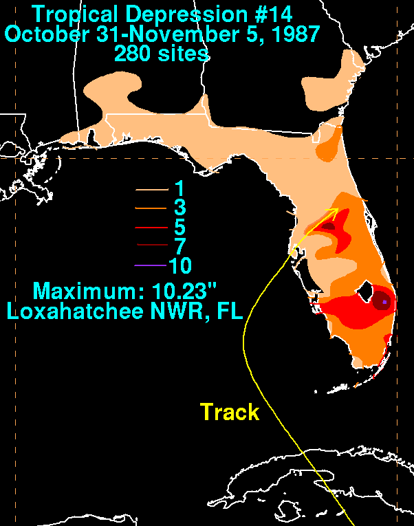
, with a peak of 10.23 inches (259.8 mm) at the Loxahatchee National Wildlife Refuge
in Florida. The city of Miami reported rainfall totals of 4.42 inches (112.3 mm) and 5.9 inches (149.9 mm) in the community of Tavarnier. Rainfalls above 1 inches (25.4 mm) were reported in eastern Georgia
, southern South Carolina
, eastern Mississippi
and eastern Alabama
. Rainfalls in other areas went unrecorded. Outside the damage in Jamaica, the damage to Cuba and the United States were minimal, with no other reported casualties.
1987 Atlantic hurricane season
The 1987 Atlantic hurricane season was a below-average hurricane season that was limited by an ongoing El Niño. The season officially began on June 1, 1987, and lasted until November 30, 1987, although activity began on May 25 when a tropical depression developed in the east central...
and was the third most destructive storm of the year. The depression formed on October 31, 1987 in the Caribbean Sea
Caribbean Sea
The Caribbean Sea is a sea of the Atlantic Ocean located in the tropics of the Western hemisphere. It is bounded by Mexico and Central America to the west and southwest, to the north by the Greater Antilles, and to the east by the Lesser Antilles....
, heading along a northward path into the southern Gulf of Mexico
Gulf of Mexico
The Gulf of Mexico is a partially landlocked ocean basin largely surrounded by the North American continent and the island of Cuba. It is bounded on the northeast, north and northwest by the Gulf Coast of the United States, on the southwest and south by Mexico, and on the southeast by Cuba. In...
and into Florida
Florida
Florida is a state in the southeastern United States, located on the nation's Atlantic and Gulf coasts. It is bordered to the west by the Gulf of Mexico, to the north by Alabama and Georgia and to the east by the Atlantic Ocean. With a population of 18,801,310 as measured by the 2010 census, it...
until the system was absorbed on November 4. The path and damage from the depression followed a similar path to Hurricane Floyd
Hurricane Floyd (1987)
Hurricane Floyd was the only hurricane to make landfall in the United States in the 1987 Atlantic hurricane season. The final of seven tropical storms and three hurricanes, Floyd developed on October 9 just off the east coast of Nicaragua. After becoming a tropical storm, it moved northward...
earlier in October. The depression peaked in intensity with wind speeds of 35 mph (55 km/h) on November 1 with a minimal barometric pressure reading of 1004 millibars (29.65 inHg). However, certain barometric readings have considered that the depression may have become a tropical storm.
The depression in the time affected several cities and parishes in Jamaica
Jamaica
Jamaica is an island nation of the Greater Antilles, in length, up to in width and 10,990 square kilometres in area. It is situated in the Caribbean Sea, about south of Cuba, and west of Hispaniola, the island harbouring the nation-states Haiti and the Dominican Republic...
and Cuba
Cuba
The Republic of Cuba is an island nation in the Caribbean. The nation of Cuba consists of the main island of Cuba, the Isla de la Juventud, and several archipelagos. Havana is the largest city in Cuba and the country's capital. Santiago de Cuba is the second largest city...
, along with causing significant rainfall in southern Florida. Jamaica was the area hardest hit by the depression, claiming the lives of six people and causing about $1.802 million (1987 USD, $3 million in 2009 USD) in damage. The depression caused floods that washed out villages, roads and bridges and caused dozens of landslides on the island. The island also had several rivers overflow including the Rio Minho
Rio Minho (Jamaica)
At the Rio Minho is the longest river in Jamaica. It rises close to the island's geographic centre, flows generally south-southwest and reaches the Caribbean Sea at Carlisle Bay in the central south coast, to the west of the island's southernmost point, Portland Point.The town of May Pen,...
and Rio Dogna. The damage caused by the tropical depression was comparable to previous flood in June 1986
Tropical Storm Andrew (1986)
Tropical Storm Andrew was a small, moderate tropical storm that formed in early June 1986. The first named storm of the 1986 Atlantic hurricane season, Andrew developed from a large, northward bound area of disturbed weather. Although it reached its peak intensity as a tropical storm, the initial...
.
Meteorological history
Prior to the formation of Tropical Depression Fourteen, the southern Caribbean SeaCaribbean Sea
The Caribbean Sea is a sea of the Atlantic Ocean located in the tropics of the Western hemisphere. It is bounded by Mexico and Central America to the west and southwest, to the north by the Greater Antilles, and to the east by the Lesser Antilles....
was under a large area of low pressure
Low pressure area
A low-pressure area, or "low", is a region where the atmospheric pressure at sea level is below that of surrounding locations. Low-pressure systems form under areas of wind divergence which occur in upper levels of the troposphere. The formation process of a low-pressure area is known as...
. On October 30, satellite imagery showed that the area of pressure was beginning to form into a tropical disturbance
Tropical wave
Tropical waves, easterly waves, or tropical easterly waves, also known as African easterly waves in the Atlantic region, are a type of atmospheric trough, an elongated area of relatively low air pressure, oriented north to south, which move from east to west across the tropics causing areas of...
. A reconnaissance
Reconnaissance
Reconnaissance is the military term for exploring beyond the area occupied by friendly forces to gain information about enemy forces or features of the environment....
aircraft was scheduled for the next morning to investigate the forming system, but by 1400 UTC on October 31, the National Hurricane Center
National Hurricane Center
The National Hurricane Center , located at Florida International University in Miami, Florida, is the division of the National Weather Service responsible for tracking and predicting weather systems within the tropics between the Prime Meridian and the 140th meridian west poleward to the 30th...
in Miami, Florida
Miami, Florida
Miami is a city located on the Atlantic coast in southeastern Florida and the county seat of Miami-Dade County, the most populous county in Florida and the eighth-most populous county in the United States with a population of 2,500,625...
had upgraded the system to a tropical depression based on the imagery and surface data. At this time, the specialists at the Hurricane Center believed that this was its most developed stage of its lifetime.
The depression began a movement to the northwest upon formation and on the night of October 31, the depression ran into a newly-forming upper-level low near the Yucatan Peninsula
Yucatán Peninsula
The Yucatán Peninsula, in southeastern Mexico, separates the Caribbean Sea from the Gulf of Mexico, with the northern coastline on the Yucatán Channel...
. The interaction with the upper-level low caused shearing
Wind shear
Wind shear, sometimes referred to as windshear or wind gradient, is a difference in wind speed and direction over a relatively short distance in the atmosphere...
in the depression, and broke apart the previous low-level circulation that was developing. By the morning of November 1, the depression was nothing more than a swirl of low-level clouds near the center of circulation. After this, the depression could no longer attain the circulation it had previously developed. During the period of November 2 and 3, the depression moved to the northeast, crossing over the islands of Jamaica
Jamaica
Jamaica is an island nation of the Greater Antilles, in length, up to in width and 10,990 square kilometres in area. It is situated in the Caribbean Sea, about south of Cuba, and west of Hispaniola, the island harbouring the nation-states Haiti and the Dominican Republic...
and Cuba
Cuba
The Republic of Cuba is an island nation in the Caribbean. The nation of Cuba consists of the main island of Cuba, the Isla de la Juventud, and several archipelagos. Havana is the largest city in Cuba and the country's capital. Santiago de Cuba is the second largest city...
and then entering the southern parts of the Gulf of Mexico
Gulf of Mexico
The Gulf of Mexico is a partially landlocked ocean basin largely surrounded by the North American continent and the island of Cuba. It is bounded on the northeast, north and northwest by the Gulf Coast of the United States, on the southwest and south by Mexico, and on the southeast by Cuba. In...
.
Naval Air Station
A Naval Air Station is a military airbase, and consists of a permanent land-based operations locations for the military aviation division of the relevant branch of their Navy...
at Boca Chica, Florida reported winds of 50 mph (80 km/h), which would mean the depression may have attained tropical storm status. A similar report was filed at the Air Force Station at Cudjoe Key
Cudjoe Key, Florida
Cudjoe Key is a census-designated place in Monroe County, Florida, on an island of the same name in the lower Florida Keys. As of the 2000 census, the CDP had a total population of 1,695.It was originally called Littleton Island....
. After another reconnaissance flight was sent out to study the system, and recorded that surface area temperatures had dropped, the flight-level winds had reached 92 mph (147 km/h) and the surface area pressure had reached 998 millibars (29.47 inHg). In the evening and overnight hours of November 3, the tropical depression continued to the northeast, making landfall in Florida at a location near Tampa Bay
Tampa Bay
Tampa Bay is a large natural harbor and estuary along the Gulf of Mexico on the west central coast of Florida, comprising Hillsborough Bay, Old Tampa Bay, Middle Tampa Bay, and Lower Tampa Bay."Tampa Bay" is not the name of any municipality...
. The depression crossed Florida, weakening significantly, and becoming extratropical. After emerging from land in the Atlantic Ocean
Atlantic Ocean
The Atlantic Ocean is the second-largest of the world's oceanic divisions. With a total area of about , it covers approximately 20% of the Earth's surface and about 26% of its water surface area...
on November 5, the depression had become a low pressure area once again and was last spotted that day near the Carolina Capes.
Preparations and impact
The flash flood warnings released in relation to Tropical Depression Fourteen were centered in the area of Jamaica, who would later received rainfall in excess of 9 inches (228.6 mm) as the center of the depression moved across the island. In the United States, the National Hurricane Center issued two tropical storm warnings in FloridaFlorida
Florida is a state in the southeastern United States, located on the nation's Atlantic and Gulf coasts. It is bordered to the west by the Gulf of Mexico, to the north by Alabama and Georgia and to the east by the Atlantic Ocean. With a population of 18,801,310 as measured by the 2010 census, it...
. The first was from the middle and lower islands of the Florida Keys
Florida Keys
The Florida Keys are a coral archipelago in southeast United States. They begin at the southeastern tip of the Florida peninsula, about south of Miami, and extend in a gentle arc south-southwest and then westward to Key West, the westernmost of the inhabited islands, and on to the uninhabited Dry...
to the area of Dry Tortugas
Dry Tortugas
The Dry Tortugas are a small group of islands, located at the end of the Florida Keys, USA, about west of Key West, and west of the Marquesas Keys, the closest islands. Still further west is the Tortugas Bank, which is completely submerged. The first Europeans to discover the islands were the...
on November 1. The warning lasted only 24 hours, with the warning ending on November 2. The second issued tropical storm warning was from the area of Fort Myers Beach
Fort Myers Beach, Florida
Fort Myers Beach is a town located on Estero Island in Lee County, Florida, United States. The population was 6,561 at the 2000 census. It is part of the Cape Coral–Fort Myers Metropolitan Statistical Area.-Geography:...
to Cedar Key
Cedar Key, Florida
Cedar Key is a city in Levy County, Florida, United States. The population was 790 at the 2000 census. According to the U.S Census estimates of 2005, the city had a population of 958. The Cedar Keys are a cluster of islands close to the mainland. Most of the developed area of the city has been on...
on November 3. This also lasted only 24 hours and was discontinued on November 3. Forecasters also suggested on November 2 that boaters should avoid the area in or around Key Largo.
Cudjoe Key, Florida
Cudjoe Key is a census-designated place in Monroe County, Florida, on an island of the same name in the lower Florida Keys. As of the 2000 census, the CDP had a total population of 1,695.It was originally called Littleton Island....
Air Force Base on November 3. The Naval Air Station at Boca Chica reported gusts around 65 mph (105 km/h) and sustained winds of about 50 mph (80 km/h) on November 2. The highest recorded winds over Cuba
Cuba
The Republic of Cuba is an island nation in the Caribbean. The nation of Cuba consists of the main island of Cuba, the Isla de la Juventud, and several archipelagos. Havana is the largest city in Cuba and the country's capital. Santiago de Cuba is the second largest city...
reached 25 mph (30 km/h) in the capital city of Havana. There were no gusts reported in Cuba however. In Jamaica
Jamaica
Jamaica is an island nation of the Greater Antilles, in length, up to in width and 10,990 square kilometres in area. It is situated in the Caribbean Sea, about south of Cuba, and west of Hispaniola, the island harbouring the nation-states Haiti and the Dominican Republic...
, gusts to 58 mph (93 km/h) were reported in the city of Kingston
Kingston, Jamaica
Kingston is the capital and largest city of Jamaica, located on the southeastern coast of the island. It faces a natural harbour protected by the Palisadoes, a long sand spit which connects the town of Port Royal and the Norman Manley International Airport to the rest of the island...
and sustained winds of about 45 mph (55 km/h). Ships also reported tropical storm force winds, reaching as high as 60 mph (100 km/h) with seas of 32.5 feet (9.9 m).
As the depression was moving to the west of the island of Jamaica, it caused significant rainfall on several parts of the island. Over a three-day period from October 31 to November 2, the rainfall reached as high as 10.21 inches (259.3 mm) at the capital city of Kingston, with a daily high of 6.38 inches (162.1 mm) on November 1. The significant rainfall caused major damage and issues on the island, with an estimated 1,000+ people being displaced from their homes and being placed into government shelters. Several residential communities were totally underwater from the rainfall, with local roads being washed away from landslides and floodwater, but these were restored quickly. The government of Jamaica also reported that three bridges were washed away from the heavy rain and resulting floods. According to the government, the country received $587,500 (1987 USD) of damage to the highways and streets, $11,000 (1987 USD) to the utilities around the island, $836,000 (1987 USD) to the agriculture system and about $372,000 to the health system. The total damage reached $1.802 million (1987 USD, $3 million in 2009 USD) on the island of Jamaica alone. There were also six recorded fatalities from the system.
In Cuba, the reported rainfall amounts reached about 4.75 inches (120.7 mm) in the community of Bahia Honda
Bahia Honda, Cuba
Bahía Honda is a municipality and city in the Artemisa Province of Cuba. Before 2011 belonged to Pinar del Río Province. It is located on the northern shore of the island, in an inlet of the Florida Straits, west of Havana. The sheltered bay that gives the name of the municipality contains an...
, along with 2.03 inches (51.6 mm) in the capital of Havana, and 2.75 inches (69.9 mm) in the community of Saua La Grande. Although by the time the depression had reached the United States was undeveloped, the remains caused significant rainfall in several states in southeastern United States
United States
The United States of America is a federal constitutional republic comprising fifty states and a federal district...
, with a peak of 10.23 inches (259.8 mm) at the Loxahatchee National Wildlife Refuge
Loxahatchee National Wildlife Refuge
The 147,392 acre Arthur R. Marshall Loxahatchee National Wildlife Refuge includes the most northern remnant of the historic Everglades wetland ecosystem...
in Florida. The city of Miami reported rainfall totals of 4.42 inches (112.3 mm) and 5.9 inches (149.9 mm) in the community of Tavarnier. Rainfalls above 1 inches (25.4 mm) were reported in eastern Georgia
Georgia (U.S. state)
Georgia is a state located in the southeastern United States. It was established in 1732, the last of the original Thirteen Colonies. The state is named after King George II of Great Britain. Georgia was the fourth state to ratify the United States Constitution, on January 2, 1788...
, southern South Carolina
South Carolina
South Carolina is a state in the Deep South of the United States that borders Georgia to the south, North Carolina to the north, and the Atlantic Ocean to the east. Originally part of the Province of Carolina, the Province of South Carolina was one of the 13 colonies that declared independence...
, eastern Mississippi
Mississippi
Mississippi is a U.S. state located in the Southern United States. Jackson is the state capital and largest city. The name of the state derives from the Mississippi River, which flows along its western boundary, whose name comes from the Ojibwe word misi-ziibi...
and eastern Alabama
Alabama
Alabama is a state located in the southeastern region of the United States. It is bordered by Tennessee to the north, Georgia to the east, Florida and the Gulf of Mexico to the south, and Mississippi to the west. Alabama ranks 30th in total land area and ranks second in the size of its inland...
. Rainfalls in other areas went unrecorded. Outside the damage in Jamaica, the damage to Cuba and the United States were minimal, with no other reported casualties.
See also
- List of Atlantic hurricanes
- List of tropical cyclones
- List of Florida hurricanes
- Beaufort scaleBeaufort scaleThe Beaufort Scale is an empirical measure that relates wind speed to observed conditions at sea or on land. Its full name is the Beaufort Wind Force Scale.-History:...
-for storms below hurricane status.
External links
- [ftp://ftp.nhc.noaa.gov/pub/storm_archives/atlantic/prelimat/atl1987/ Detailed information on all storms from 1987]
- Tropical Depression 14 Information (HPC)