
.gif)
Tropical Storm Marco (1990)
Encyclopedia
Tropical Storm Marco was the only tropical cyclone
to make landfall
on the United States
during the 1990 Atlantic hurricane season
. The 13th named storm of the season, Marco formed from a cold-core
low pressure area
along the northern coast of Cuba
on October 9, and tracked northwestward through the eastern Gulf of Mexico
. With most of its circulation over the western portion of Florida, Tropical Storm Marco produced 65 mph (100 km/h) winds over land. However, it weakened to a tropical depression before moving ashore near Cedar Key
. The cyclone combined with a cold front
and the remnants of Hurricane Klaus
to produce heavy rainfall in Georgia
and the Carolinas
. After interacting with the nearby Hurricane Lili
, Marco continued northward until being absorbed by a cold front on October 13.
In Florida
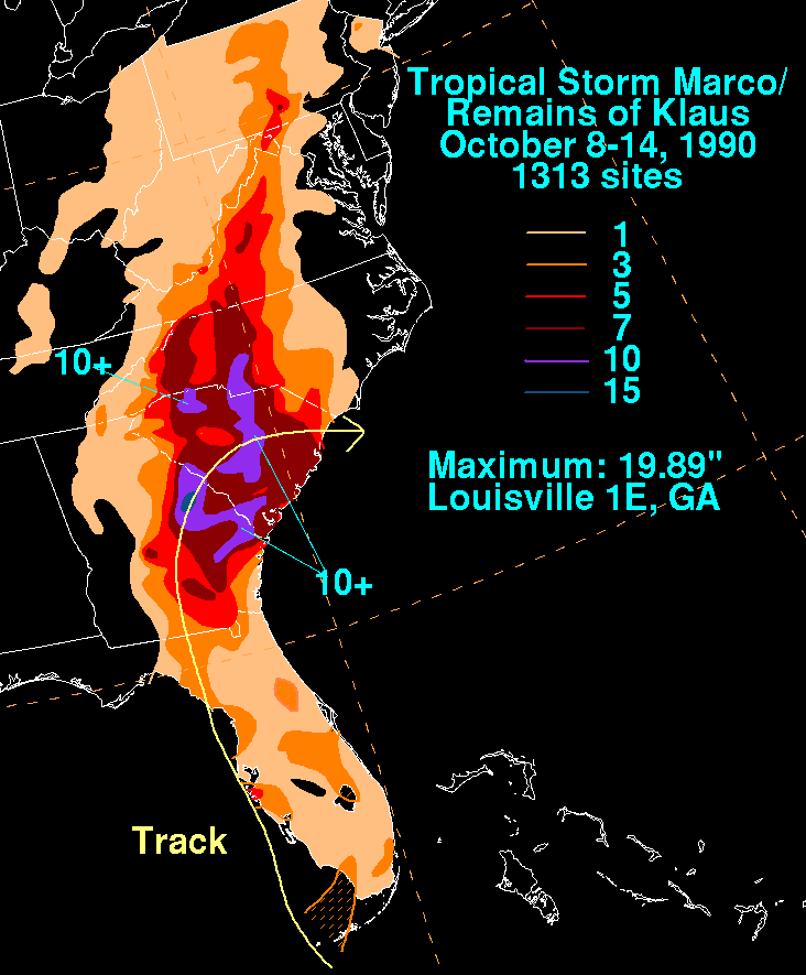
, the cyclone triggered flooding of some houses and roadways. Rainfall across its path peaked at 19.89 inches (505 mm) in Louisville, Georgia
, though several locations received over 10 inches (250 mm) of precipitation. The flooding caused a total of 12 deaths, mostly due to drowning, as well as $57 million in damage (1990 USD, $ USD).
and circulation persisted over eastern Cuba in the middle levels of the atmosphere. The low drifted westward, and interacted with Hurricane Klaus
to its east. Initially cold-core
in nature, the system gradually built downward to the surface, and on October 9, the low developed a low-level circulation; at 1200 UTC
the National Hurricane Center
classified it as Tropical Depression Fifteen while located near the Cuban city of Caibarién
, though the cyclone was initially subtropical
in character. To its east, Tropical Storm Klaus continued to weaken; the depression absorbed most of Klaus and became the dominant system. The storm tracked parallel to the coast of Cuba before veering northward and crossing the Florida Keys
, where it intensified into Tropical Storm Marco about 35 mi (55 km) south-southeast of Key West, Florida
.
After passing midway between Key West and the Dry Tortugas
, Tropical Storm Marco adopted a steady northward track and quickly intensified, reaching peak winds of 65 mph (100 km/h) on October 11, while still southwest of Englewood, Florida
. The center of the storm continued on its off-shore parallel for another six hours after reaching its peak intensity, until it reached a position about six mi (10 km) west of Bradenton Beach
; although the center of the storm remained offshore, much of its circulation was over land. Initially the storm still was forecast to move ashore between Fort Myers
and Sarasota
. However, the cyclone continued its northward trajectory, the center remaining offshore, and it weakened to a tropical depression prior to making landfall
near Cedar Key
early on October 12.
After landfall, the cyclone accelerated in forward speed northward, weakening in intensity, and, by 1200 UTC on October 12, Marco became an extra-tropical cyclone. It turned to the northeast and east through South Carolina
, following behind Hurricane Lili
to its northeast. For a time, the system's proximity to Lili resulted in hints of the Fujiwhara effect
, in which two tropical cyclone appear to rotate around each other. The cold front that absorbed the weakening low was to the storm's north on October 13, though moisture from the remnants of Marco dropped heavy rainfall across the southeast United States for another day.
was issued at some point during the existence of the cyclone for the west coast of Florida
from Key West
to Apalachicola
. Additionally, a tropical storm warning was put in place for the east coast from Vero Beach
northward to Fernandina Beach
. Before the arrival of Marco, elementary schools were closed on the three barrier island
s in Lee County
. Florida governor Bob Martinez
ordered the closure of state offices in the Tampa Bay
area, and also decided not to open the University of South Florida
and nearby community colleges. Public schools were not opened on the day of the storm's passage in Manatee
and Sarasota
counties, though most other schools remained open. As the storm tracked northward, the National Weather Service
issued a flood watch for much of Georgia
. A flood watch was later issued for western portions of the Carolinas
and for high elevations in Virginia
and West Virginia
.
 With most of its circulation over the western portion of Florida
during its existence, Tropical Storm Marco produced 39–74 mph winds across western Florida. As it brushed the coastline, the storm developed strong convective rain bands, leading to peak sustained winds of 69 mph (112 km/h) with gusts to 85 mph (137 km/h) on the Sunshine Skyway Bridge
; the bridge was closed after gusts reached 70 mph (115 km/h). Squall
s from the storm spawned four tornadoes in the state, one of which struck the city of Crystal River
, destroying a mobile home and left 2,000 people without power for about an hour. Storm damage left about 25,000 customers across the state without power and about 40 families temporarily homeless.
Paralleling the coastline, the storm produced a light storm surge
that peaked at 2.6 feet (0.8 m) above normal on Sanibel Island
. In some locations, the surge rose rapidly, and, despite the unusual geography of the area, the levels varied only by as much as 9.8 inches (250 mm) than the predicted levels from the SLOSH
model. The surge and waves caused minor beach erosion. Moderate to heavy rainfall fell across western Florida, peaking at 6.14 inches (156 mm) near Bradenton
; the rainfall was beneficial after a very dry summer, though, because it fell quickly, even this amount of precipitation failed to relieve water restrictions across the area. The storm resulted in some flooding in its path, including some several homes in Manatee County
, roadways, and two U.S. highways
. State-wide damage totalled $3 million (1990 USD, $ USD), of which $1 million (1990 USD, $ USD) occurred in Manatee County.
, they combined with the remnant moisture from Hurricane Klaus
and a slow-moving cold front, which caused large amounts of precipitation to fall across the eastern portion of the state. Rainfall peaked at 19.89 inches (505 mm) at a weather station near Louisville
, Georgia where over 16 inches (400 mm) fell in a 24 hour period. In Augusta
, 2.79 inches (71 mm) of rainfall fell in one hour, which forced the evacuation of about 300 people. Some roads in eastern Georgia were flooded up to 6 feet (1.8 m) deep, and police officers in Augusta rescued people in flooded cars. The flooding resulted in some power outages. In the deluge, five people drowned, and 450 were left homeless. The remnants of the storm spawned a tornado in Brantley County
, which destroyed 25 unoccupied homes. Damage in Georgia totaled $42 million (1990 USD, $ USD). On October 19, 1990, President George H. W. Bush
declared several counties in Georgia as federal disaster areas, which permitted the use of emergency funds for victims.
Heavy rainfall continued northward into the Carolinas. Much of South Carolina
experienced over 7 inches (175 mm) of precipitation; statewide, the rainfall peaked at 13.96 inches (355 mm) in Pageland
. The highest totals in 100 years in some locations also ended a severe drought. In the flooding, 80 bridges in the state failed; in total, more than 120 bridges were either closed, damaged, or destroyed. In South Carolina, the system caused three drowning deaths; damage totaled $12 million (1990, $ USD). In North Carolina
, rainfall reached 10.74 inches (273 mm) in Albemarle
. The storm directly caused two deaths in North Carolia, and indirectly caused two traffic deaths.
Rainfall from the combined remnants of Marco and Klaus extended into the Ohio Valley
, with 3.67 inches (93 mm) recorded near Mountain City, Tennessee
. Totals of 2–5 inches (50–125 mm) spread across northwest Virginia
, western Maryland
, eastern West Virginia
, and the Susquehanna Valley
of Pennsylvania
. In New York
, the rainfall combined with moisture from Hurricane Lili
, which triggered flooding that closed a portion of a railway line and a highway.
Tropical Storm Marco was the only storm to strike the United States during the 1990 hurricane season; without Marco, the season would have been the first to have no tropical storm or hurricane make landfall in the US since the 1890 season
.
Tropical cyclone
A tropical cyclone is a storm system characterized by a large low-pressure center and numerous thunderstorms that produce strong winds and heavy rain. Tropical cyclones strengthen when water evaporated from the ocean is released as the saturated air rises, resulting in condensation of water vapor...
to make landfall
Landfall (meteorology)
Landfall is the event of a tropical cyclone or a waterspout coming onto land after being over water. When a waterspout makes landfall it is reclassified as a tornado, which can then cause damage inland...
on the United States
United States
The United States of America is a federal constitutional republic comprising fifty states and a federal district...
during the 1990 Atlantic hurricane season
1990 Atlantic hurricane season
The 1990 Atlantic hurricane season was the most active Atlantic hurricane season since 1969. It officially began on June 1, 1990, and lasted until November 30, 1990. These dates conventionally delimit the period of each year when most tropical cyclones form in the Atlantic basin...
. The 13th named storm of the season, Marco formed from a cold-core
Cold-core low
A cold-core low, also known as a cold low or cold-core cyclone, is a cyclone aloft which has an associated cold pool of air residing at high altitude within the Earth's troposphere. It is a low pressure system which strengthens with height in accordance with the thermal wind relationship. These...
low pressure area
Low pressure area
A low-pressure area, or "low", is a region where the atmospheric pressure at sea level is below that of surrounding locations. Low-pressure systems form under areas of wind divergence which occur in upper levels of the troposphere. The formation process of a low-pressure area is known as...
along the northern coast of Cuba
Cuba
The Republic of Cuba is an island nation in the Caribbean. The nation of Cuba consists of the main island of Cuba, the Isla de la Juventud, and several archipelagos. Havana is the largest city in Cuba and the country's capital. Santiago de Cuba is the second largest city...
on October 9, and tracked northwestward through the eastern Gulf of Mexico
Gulf of Mexico
The Gulf of Mexico is a partially landlocked ocean basin largely surrounded by the North American continent and the island of Cuba. It is bounded on the northeast, north and northwest by the Gulf Coast of the United States, on the southwest and south by Mexico, and on the southeast by Cuba. In...
. With most of its circulation over the western portion of Florida, Tropical Storm Marco produced 65 mph (100 km/h) winds over land. However, it weakened to a tropical depression before moving ashore near Cedar Key
Cedar Key, Florida
Cedar Key is a city in Levy County, Florida, United States. The population was 790 at the 2000 census. According to the U.S Census estimates of 2005, the city had a population of 958. The Cedar Keys are a cluster of islands close to the mainland. Most of the developed area of the city has been on...
. The cyclone combined with a cold front
Cold front
A cold front is defined as the leading edge of a cooler mass of air, replacing a warmer mass of air.-Development of cold front:The cooler and denser air wedges under the less-dense warmer air, lifting it...
and the remnants of Hurricane Klaus
Hurricane Klaus
Hurricane Klaus was a minimal Atlantic hurricane that dropped heavy rainfall across the Lesser Antilles in October 1990. The eleventh tropical cyclone and sixth hurricane of the 1990 Atlantic hurricane season, Klaus developed from a tropical wave on October 3 a short distance east of Dominica. It...
to produce heavy rainfall in Georgia
Georgia (U.S. state)
Georgia is a state located in the southeastern United States. It was established in 1732, the last of the original Thirteen Colonies. The state is named after King George II of Great Britain. Georgia was the fourth state to ratify the United States Constitution, on January 2, 1788...
and the Carolinas
The Carolinas
The Carolinas is a term used in the United States to refer collectively to the states of North and South Carolina. Together, the two states + have a population of 13,942,126. "Carolina" would be the fifth most populous state behind California, Texas, New York, and Florida...
. After interacting with the nearby Hurricane Lili
Hurricane Lili (1990)
Hurricane Lili was a moderate tropical cyclone of the 1990 Atlantic hurricane season. It began as a subtropical cyclone over the central Atlantic and became a hurricane while moving westward toward the United States. Lili did not gain any additional strength before curving away from land and...
, Marco continued northward until being absorbed by a cold front on October 13.
In Florida
Florida
Florida is a state in the southeastern United States, located on the nation's Atlantic and Gulf coasts. It is bordered to the west by the Gulf of Mexico, to the north by Alabama and Georgia and to the east by the Atlantic Ocean. With a population of 18,801,310 as measured by the 2010 census, it...
, the cyclone triggered flooding of some houses and roadways. Rainfall across its path peaked at 19.89 inches (505 mm) in Louisville, Georgia
Louisville, Georgia
Louisville is a city in Jefferson County, Georgia, United States. It is the former capital of Georgia and is the county seat of Jefferson County. It is located southwest of Augusta on the Ogeechee River, and its population was 2,712 at the 2000 census. The local pronunciation is the Americanized...
, though several locations received over 10 inches (250 mm) of precipitation. The flooding caused a total of 12 deaths, mostly due to drowning, as well as $57 million in damage (1990 USD, $ USD).
Meteorological history
By early on October 6, a low pressure areaLow pressure area
A low-pressure area, or "low", is a region where the atmospheric pressure at sea level is below that of surrounding locations. Low-pressure systems form under areas of wind divergence which occur in upper levels of the troposphere. The formation process of a low-pressure area is known as...
and circulation persisted over eastern Cuba in the middle levels of the atmosphere. The low drifted westward, and interacted with Hurricane Klaus
Hurricane Klaus
Hurricane Klaus was a minimal Atlantic hurricane that dropped heavy rainfall across the Lesser Antilles in October 1990. The eleventh tropical cyclone and sixth hurricane of the 1990 Atlantic hurricane season, Klaus developed from a tropical wave on October 3 a short distance east of Dominica. It...
to its east. Initially cold-core
Extratropical cyclone
Extratropical cyclones, sometimes called mid-latitude cyclones or wave cyclones, are a group of cyclones defined as synoptic scale low pressure weather systems that occur in the middle latitudes of the Earth having neither tropical nor polar characteristics, and are connected with fronts and...
in nature, the system gradually built downward to the surface, and on October 9, the low developed a low-level circulation; at 1200 UTC
Coordinated Universal Time
Coordinated Universal Time is the primary time standard by which the world regulates clocks and time. It is one of several closely related successors to Greenwich Mean Time. Computer servers, online services and other entities that rely on having a universally accepted time use UTC for that purpose...
the National Hurricane Center
National Hurricane Center
The National Hurricane Center , located at Florida International University in Miami, Florida, is the division of the National Weather Service responsible for tracking and predicting weather systems within the tropics between the Prime Meridian and the 140th meridian west poleward to the 30th...
classified it as Tropical Depression Fifteen while located near the Cuban city of Caibarién
Caibarién
Caibarién is a municipality city in the Villa Clara province of Cuba.Caibarien is known as "La Villa Blanca" for its sands and beaches. They are famous for their "Parrandas" along with Remedios and Camajuani.-History:The town was founded on October 26, 1832 from a map designed by Estratón Bauza...
, though the cyclone was initially subtropical
Subtropical cyclone
A subtropical cyclone is a weather system that has some characteristics of a tropical and an extratropical cyclone. As early as the 1950s, meteorologists were unclear whether they should be characterized as tropical or extratropical cyclones. They were officially recognized by the National...
in character. To its east, Tropical Storm Klaus continued to weaken; the depression absorbed most of Klaus and became the dominant system. The storm tracked parallel to the coast of Cuba before veering northward and crossing the Florida Keys
Florida Keys
The Florida Keys are a coral archipelago in southeast United States. They begin at the southeastern tip of the Florida peninsula, about south of Miami, and extend in a gentle arc south-southwest and then westward to Key West, the westernmost of the inhabited islands, and on to the uninhabited Dry...
, where it intensified into Tropical Storm Marco about 35 mi (55 km) south-southeast of Key West, Florida
Key West, Florida
Key West is a city in Monroe County, Florida, United States. The city encompasses the island of Key West, the part of Stock Island north of U.S. 1 , Sigsbee Park , Fleming Key , and Sunset Key...
.
After passing midway between Key West and the Dry Tortugas
Dry Tortugas
The Dry Tortugas are a small group of islands, located at the end of the Florida Keys, USA, about west of Key West, and west of the Marquesas Keys, the closest islands. Still further west is the Tortugas Bank, which is completely submerged. The first Europeans to discover the islands were the...
, Tropical Storm Marco adopted a steady northward track and quickly intensified, reaching peak winds of 65 mph (100 km/h) on October 11, while still southwest of Englewood, Florida
Englewood, Florida
Englewood is a census-designated place in Charlotte and Sarasota counties in the U.S. state of Florida. As of the 2000 census, it had a population of 16,196.Englewood also was the original name for Vineland, Florida...
. The center of the storm continued on its off-shore parallel for another six hours after reaching its peak intensity, until it reached a position about six mi (10 km) west of Bradenton Beach
Bradenton Beach, Florida
Bradenton Beach is a city on Anna Maria Island in Manatee County, Florida, United States. The population was 1,482 at the 2000 census, and 1,561 in the U.S Census estimates of 2005. It is part of the Bradenton–Sarasota–Venice Metropolitan Statistical Area. The city occupies the southern...
; although the center of the storm remained offshore, much of its circulation was over land. Initially the storm still was forecast to move ashore between Fort Myers
Fort Myers, Florida
Fort Myers is the county seat and commercial center of Lee County, Florida, United States. Its population was 62,298 in the 2010 census, a 29.23 percent increase over the 2000 figure....
and Sarasota
Sarasota, Florida
Sarasota is a city located in Sarasota County on the southwestern coast of the U.S. state of Florida. It is south of the Tampa Bay Area and north of Fort Myers...
. However, the cyclone continued its northward trajectory, the center remaining offshore, and it weakened to a tropical depression prior to making landfall
Landfall (meteorology)
Landfall is the event of a tropical cyclone or a waterspout coming onto land after being over water. When a waterspout makes landfall it is reclassified as a tornado, which can then cause damage inland...
near Cedar Key
Cedar Key, Florida
Cedar Key is a city in Levy County, Florida, United States. The population was 790 at the 2000 census. According to the U.S Census estimates of 2005, the city had a population of 958. The Cedar Keys are a cluster of islands close to the mainland. Most of the developed area of the city has been on...
early on October 12.
After landfall, the cyclone accelerated in forward speed northward, weakening in intensity, and, by 1200 UTC on October 12, Marco became an extra-tropical cyclone. It turned to the northeast and east through South Carolina
South Carolina
South Carolina is a state in the Deep South of the United States that borders Georgia to the south, North Carolina to the north, and the Atlantic Ocean to the east. Originally part of the Province of Carolina, the Province of South Carolina was one of the 13 colonies that declared independence...
, following behind Hurricane Lili
Hurricane Lili (1990)
Hurricane Lili was a moderate tropical cyclone of the 1990 Atlantic hurricane season. It began as a subtropical cyclone over the central Atlantic and became a hurricane while moving westward toward the United States. Lili did not gain any additional strength before curving away from land and...
to its northeast. For a time, the system's proximity to Lili resulted in hints of the Fujiwhara effect
Fujiwhara effect
The Fujiwhara effect or Fujiwara interaction, named after Sakuhei Fujiwhara, is a type of interaction between two nearby cyclonic vortices, causing them to appear to "orbit" each other.-Description:...
, in which two tropical cyclone appear to rotate around each other. The cold front that absorbed the weakening low was to the storm's north on October 13, though moisture from the remnants of Marco dropped heavy rainfall across the southeast United States for another day.
Preparations
A tropical storm warningTropical cyclone warnings and watches
Warnings and watches are two levels of alert issued by national weather forecasting bodies to coastal areas threatened by the imminent approach of a tropical cyclone of tropical storm or hurricane intensity. They are notices to the local population and civil authorities to make appropriate...
was issued at some point during the existence of the cyclone for the west coast of Florida
Florida
Florida is a state in the southeastern United States, located on the nation's Atlantic and Gulf coasts. It is bordered to the west by the Gulf of Mexico, to the north by Alabama and Georgia and to the east by the Atlantic Ocean. With a population of 18,801,310 as measured by the 2010 census, it...
from Key West
Key West, Florida
Key West is a city in Monroe County, Florida, United States. The city encompasses the island of Key West, the part of Stock Island north of U.S. 1 , Sigsbee Park , Fleming Key , and Sunset Key...
to Apalachicola
Apalachicola, Florida
Apalachicola is a city in Franklin County, Florida, on US 98 about southwest of Tallahassee. The population was 2,334 at the 2000 census. The 2005 census estimated the city's population at 2,340...
. Additionally, a tropical storm warning was put in place for the east coast from Vero Beach
Vero Beach, Florida
Vero Beach is a city in Indian River County, Florida, USA. According to the U.S. Census Bureau's 2006 estimates, the city had a population of 16,939. It is the county seat of Indian River County...
northward to Fernandina Beach
Fernandina Beach, Florida
Fernandina Beach is a city in Nassau County in the state of Florida in the United States of America and on Amelia Island. It is a part of Greater Jacksonville and is among Florida's northernmost cities. The area was first inhabited by the Timucuan Indian tribe...
. Before the arrival of Marco, elementary schools were closed on the three barrier island
Barrier island
Barrier islands, a coastal landform and a type of barrier system, are relatively narrow strips of sand that parallel the mainland coast. They usually occur in chains, consisting of anything from a few islands to more than a dozen...
s in Lee County
Lee County, Florida
Lee County is a county located in the U.S. state of Florida. Located in southwest Florida, the principal cities in the county are Fort Myers and Cape Coral...
. Florida governor Bob Martinez
Bob Martinez
Robert Martinez was the 40th Governor of Florida from 1987 to 1991. Prior to that, he was the mayor of Tampa from 1979 to 1986.- Education and early career :...
ordered the closure of state offices in the Tampa Bay
Tampa Bay
Tampa Bay is a large natural harbor and estuary along the Gulf of Mexico on the west central coast of Florida, comprising Hillsborough Bay, Old Tampa Bay, Middle Tampa Bay, and Lower Tampa Bay."Tampa Bay" is not the name of any municipality...
area, and also decided not to open the University of South Florida
University of South Florida
The University of South Florida, also known as USF, is a member institution of the State University System of Florida, one of the state's three flagship universities for public research, and is located in Tampa, Florida, USA...
and nearby community colleges. Public schools were not opened on the day of the storm's passage in Manatee
Manatee County, Florida
Manatee County is a county in the state of Florida. According to the 2010 census by the U.S. Census Bureau there are 322,833 people living in Manatee Country.Manatee County is part of the North Port-Bradenton-Sarasota Metropolitan Statistical Area...
and Sarasota
Sarasota County, Florida
Sarasota County is a county located in the U.S. state of Florida. The U.S. Census Bureau 2008 estimate for the county was 372,057. Its county seat is Sarasota, Florida....
counties, though most other schools remained open. As the storm tracked northward, the National Weather Service
National Weather Service
The National Weather Service , once known as the Weather Bureau, is one of the six scientific agencies that make up the National Oceanic and Atmospheric Administration of the United States government...
issued a flood watch for much of Georgia
Georgia (U.S. state)
Georgia is a state located in the southeastern United States. It was established in 1732, the last of the original Thirteen Colonies. The state is named after King George II of Great Britain. Georgia was the fourth state to ratify the United States Constitution, on January 2, 1788...
. A flood watch was later issued for western portions of the Carolinas
The Carolinas
The Carolinas is a term used in the United States to refer collectively to the states of North and South Carolina. Together, the two states + have a population of 13,942,126. "Carolina" would be the fifth most populous state behind California, Texas, New York, and Florida...
and for high elevations in Virginia
Virginia
The Commonwealth of Virginia , is a U.S. state on the Atlantic Coast of the Southern United States. Virginia is nicknamed the "Old Dominion" and sometimes the "Mother of Presidents" after the eight U.S. presidents born there...
and West Virginia
West Virginia
West Virginia is a state in the Appalachian and Southeastern regions of the United States, bordered by Virginia to the southeast, Kentucky to the southwest, Ohio to the northwest, Pennsylvania to the northeast and Maryland to the east...
.
Florida
Florida
Florida is a state in the southeastern United States, located on the nation's Atlantic and Gulf coasts. It is bordered to the west by the Gulf of Mexico, to the north by Alabama and Georgia and to the east by the Atlantic Ocean. With a population of 18,801,310 as measured by the 2010 census, it...
during its existence, Tropical Storm Marco produced 39–74 mph winds across western Florida. As it brushed the coastline, the storm developed strong convective rain bands, leading to peak sustained winds of 69 mph (112 km/h) with gusts to 85 mph (137 km/h) on the Sunshine Skyway Bridge
Sunshine Skyway Bridge
The Bob Graham Sunshine Skyway Bridge is a bridge spanning Tampa Bay, Florida, with a cable-stayed main span, and a total length of 21,877 feet . It is part of I-275 and US 19 , connecting St. Petersburg in Pinellas County and Terra Ceia in Manatee County, Florida, passing through Hillsborough...
; the bridge was closed after gusts reached 70 mph (115 km/h). Squall
Squall
A squall is a sudden, sharp increase in wind speed which is usually associated with active weather, such as rain showers, thunderstorms, or heavy snow. Squalls refer to an increase in the sustained winds over a short time interval, as there may be higher gusts during a squall event...
s from the storm spawned four tornadoes in the state, one of which struck the city of Crystal River
Crystal River, Florida
Crystal River is a city in Citrus County, Florida, United States. The population was 3,485 at the 2000 census. . According to the U.S Census estimates of 2005, the city had a population of 3,539. The city was incorporated in 1903 and is the self professed "Home of the Manatee"....
, destroying a mobile home and left 2,000 people without power for about an hour. Storm damage left about 25,000 customers across the state without power and about 40 families temporarily homeless.
Paralleling the coastline, the storm produced a light storm surge
Storm surge
A storm surge is an offshore rise of water associated with a low pressure weather system, typically tropical cyclones and strong extratropical cyclones. Storm surges are caused primarily by high winds pushing on the ocean's surface. The wind causes the water to pile up higher than the ordinary sea...
that peaked at 2.6 feet (0.8 m) above normal on Sanibel Island
Sanibel Island
Sanibel Island is an island located on the Gulf coast of Florida, just offshore of Fort Myers. In 2000, it had an estimated population of 6,064 people...
. In some locations, the surge rose rapidly, and, despite the unusual geography of the area, the levels varied only by as much as 9.8 inches (250 mm) than the predicted levels from the SLOSH
Sea, Lake, and Overland Surge from Hurricanes
Sea, Lake, and Overland Surge from Hurricanes is a computerized model developed by the Federal Emergency Management Agency , United States Army Corps of Engineers , and the National Weather Service to estimate storm surge depths resulting from historical, hypothetical, or predicted hurricanes by...
model. The surge and waves caused minor beach erosion. Moderate to heavy rainfall fell across western Florida, peaking at 6.14 inches (156 mm) near Bradenton
Bradenton, Florida
Bradenton is a city in Manatee County, Florida, United States. The U.S. Census Bureau estimated the city's 2007 population to be 53,471. Bradenton is the largest Principal City of the Bradenton-Sarasota-Venice, Florida Metropolitan Statistical Area, which had a 2007 estimated population of 682,833...
; the rainfall was beneficial after a very dry summer, though, because it fell quickly, even this amount of precipitation failed to relieve water restrictions across the area. The storm resulted in some flooding in its path, including some several homes in Manatee County
Manatee County, Florida
Manatee County is a county in the state of Florida. According to the 2010 census by the U.S. Census Bureau there are 322,833 people living in Manatee Country.Manatee County is part of the North Port-Bradenton-Sarasota Metropolitan Statistical Area...
, roadways, and two U.S. highways
United States Numbered Highways
The system of United States Numbered Highways is an integrated system of roads and highways in the United States numbered within a nationwide grid...
. State-wide damage totalled $3 million (1990 USD, $ USD), of which $1 million (1990 USD, $ USD) occurred in Manatee County.
Elsewhere
As the remnants of Marco entered GeorgiaGeorgia (U.S. state)
Georgia is a state located in the southeastern United States. It was established in 1732, the last of the original Thirteen Colonies. The state is named after King George II of Great Britain. Georgia was the fourth state to ratify the United States Constitution, on January 2, 1788...
, they combined with the remnant moisture from Hurricane Klaus
Hurricane Klaus
Hurricane Klaus was a minimal Atlantic hurricane that dropped heavy rainfall across the Lesser Antilles in October 1990. The eleventh tropical cyclone and sixth hurricane of the 1990 Atlantic hurricane season, Klaus developed from a tropical wave on October 3 a short distance east of Dominica. It...
and a slow-moving cold front, which caused large amounts of precipitation to fall across the eastern portion of the state. Rainfall peaked at 19.89 inches (505 mm) at a weather station near Louisville
Louisville, Georgia
Louisville is a city in Jefferson County, Georgia, United States. It is the former capital of Georgia and is the county seat of Jefferson County. It is located southwest of Augusta on the Ogeechee River, and its population was 2,712 at the 2000 census. The local pronunciation is the Americanized...
, Georgia where over 16 inches (400 mm) fell in a 24 hour period. In Augusta
Augusta, Georgia
Augusta is a consolidated city in the U.S. state of Georgia, located along the Savannah River. As of the 2010 census, the Augusta–Richmond County population was 195,844 not counting the unconsolidated cities of Hephzibah and Blythe.Augusta is the principal city of the Augusta-Richmond County...
, 2.79 inches (71 mm) of rainfall fell in one hour, which forced the evacuation of about 300 people. Some roads in eastern Georgia were flooded up to 6 feet (1.8 m) deep, and police officers in Augusta rescued people in flooded cars. The flooding resulted in some power outages. In the deluge, five people drowned, and 450 were left homeless. The remnants of the storm spawned a tornado in Brantley County
Brantley County, Georgia
Brantley County is a county located in the U.S. state of Georgia. It is part of the 'Brunswick, Georgia Metropolitan Statistical Area' which encompasses all of Brantley, Glynn, and McIntosh counties. As of 2000, the population is 14,629. The 2007 Census Estimate shows a population of 15,440...
, which destroyed 25 unoccupied homes. Damage in Georgia totaled $42 million (1990 USD, $ USD). On October 19, 1990, President George H. W. Bush
George H. W. Bush
George Herbert Walker Bush is an American politician who served as the 41st President of the United States . He had previously served as the 43rd Vice President of the United States , a congressman, an ambassador, and Director of Central Intelligence.Bush was born in Milton, Massachusetts, to...
declared several counties in Georgia as federal disaster areas, which permitted the use of emergency funds for victims.
Heavy rainfall continued northward into the Carolinas. Much of South Carolina
South Carolina
South Carolina is a state in the Deep South of the United States that borders Georgia to the south, North Carolina to the north, and the Atlantic Ocean to the east. Originally part of the Province of Carolina, the Province of South Carolina was one of the 13 colonies that declared independence...
experienced over 7 inches (175 mm) of precipitation; statewide, the rainfall peaked at 13.96 inches (355 mm) in Pageland
Pageland, South Carolina
Pageland is a town in Chesterfield County, South Carolina, United States. The population was 2,521 at the 2000 census.-Geography:Pageland is located at ....
. The highest totals in 100 years in some locations also ended a severe drought. In the flooding, 80 bridges in the state failed; in total, more than 120 bridges were either closed, damaged, or destroyed. In South Carolina, the system caused three drowning deaths; damage totaled $12 million (1990, $ USD). In North Carolina
North Carolina
North Carolina is a state located in the southeastern United States. The state borders South Carolina and Georgia to the south, Tennessee to the west and Virginia to the north. North Carolina contains 100 counties. Its capital is Raleigh, and its largest city is Charlotte...
, rainfall reached 10.74 inches (273 mm) in Albemarle
Albemarle, North Carolina
Albemarle is the county seat of Stanly County, North Carolina. The population was 15,680 at the 2000 census. It is governed by Mayor Elbert L. "Whit" Whitley, Jr...
. The storm directly caused two deaths in North Carolia, and indirectly caused two traffic deaths.
Rainfall from the combined remnants of Marco and Klaus extended into the Ohio Valley
Ohio River
The Ohio River is the largest tributary, by volume, of the Mississippi River. At the confluence, the Ohio is even bigger than the Mississippi and, thus, is hydrologically the main stream of the whole river system, including the Allegheny River further upstream...
, with 3.67 inches (93 mm) recorded near Mountain City, Tennessee
Mountain City, Tennessee
Mountain City is a town in Johnson County, Tennessee, United States. The population was 2,383 at the 2000 census. It is the northeasternmost county seat in Tennessee; Mountain City is the county seat of Johnson County.-History:...
. Totals of 2–5 inches (50–125 mm) spread across northwest Virginia
Virginia
The Commonwealth of Virginia , is a U.S. state on the Atlantic Coast of the Southern United States. Virginia is nicknamed the "Old Dominion" and sometimes the "Mother of Presidents" after the eight U.S. presidents born there...
, western Maryland
Maryland
Maryland is a U.S. state located in the Mid Atlantic region of the United States, bordering Virginia, West Virginia, and the District of Columbia to its south and west; Pennsylvania to its north; and Delaware to its east...
, eastern West Virginia
West Virginia
West Virginia is a state in the Appalachian and Southeastern regions of the United States, bordered by Virginia to the southeast, Kentucky to the southwest, Ohio to the northwest, Pennsylvania to the northeast and Maryland to the east...
, and the Susquehanna Valley
Susquehanna River
The Susquehanna River is a river located in the northeastern United States. At long, it is the longest river on the American east coast that drains into the Atlantic Ocean, and with its watershed it is the 16th largest river in the United States, and the longest river in the continental United...
of Pennsylvania
Pennsylvania
The Commonwealth of Pennsylvania is a U.S. state that is located in the Northeastern and Mid-Atlantic regions of the United States. The state borders Delaware and Maryland to the south, West Virginia to the southwest, Ohio to the west, New York and Ontario, Canada, to the north, and New Jersey to...
. In New York
New York
New York is a state in the Northeastern region of the United States. It is the nation's third most populous state. New York is bordered by New Jersey and Pennsylvania to the south, and by Connecticut, Massachusetts and Vermont to the east...
, the rainfall combined with moisture from Hurricane Lili
Hurricane Lili (1990)
Hurricane Lili was a moderate tropical cyclone of the 1990 Atlantic hurricane season. It began as a subtropical cyclone over the central Atlantic and became a hurricane while moving westward toward the United States. Lili did not gain any additional strength before curving away from land and...
, which triggered flooding that closed a portion of a railway line and a highway.
Tropical Storm Marco was the only storm to strike the United States during the 1990 hurricane season; without Marco, the season would have been the first to have no tropical storm or hurricane make landfall in the US since the 1890 season
1890 Atlantic hurricane season
The 1890 Atlantic hurricane season ran through the summer and the first half of fall in 1890.The 1890 season was fairly inactive, with only four storms forming. Two became hurricanes, two were tropical storms...
.
See also
External links
- [ftp://ftp.nhc.noaa.gov/pub/storm_archives/atlantic/prelimat/atl1990/marco/ NHC Marco Preliminary Report (gif format)]
- 1990 Monthly Weather Review