

Hurricane Eloise
Encyclopedia
Hurricane Eloise was the most destructive tropical cyclone
of the 1975 Atlantic hurricane season
. The fifth tropical storm, fourth hurricane, and second major hurricane of the season, Eloise formed as a tropical depression on September 13 to the east of the Virgin Islands
. The depression tracked westward as it intensified into a tropical storm and after passing to the north of Puerto Rico
, Eloise briefly attained hurricane intensity. However, the storm made landfall on Hispaniola
, causing it to weaken back into a tropical storm. A weak and disorganized cyclone, Eloise emerged into open waters of the northern Caribbean Sea, and upon striking the northern Yucatan Peninsula
, it turned north and began to re-intensify. In the Gulf of Mexico, the system quickly developed and became a Category 3 hurricane on the Saffir-Simpson Hurricane Scale
on September 23. Eloise made landfall along the Florida Panhandle
west of Panama City
before moving inland across Alabama
and eventually dissipating on September 24.
The storm produced torrential rainfall throughout Puerto Rico and Hispaniola, causing extensive flooding, over 40 deaths, and severe damage. Thousands in these areas were left homeless. As Eloise progressed westward, it affected Cuba to a lesser extent. In advance of the storm, about 100,000 residents evacuated from the Gulf Coast region. Upon making landfall in Florida, Eloise generated winds reportedly gusting to 155 mph (249.4 km/h), which caused extreme damage throughout the area. Hundreds of buildings were demolished by the powerful winds and strong storm surge. Across the United States, damage amounted to approximately $560 million. The storm killed 80 people along its track, and due to the severe damage, the name "Eloise" was retired from the list of Atlantic tropical cyclone names.
that emerged from the western coast of Africa on September 6, 1975. Satellite imagery indicated that the system was initially disjointed and poorly developed, although there was evidence of a low-level circulation. The disturbance tracked westward for several days as it slowly matured. On September 13, a ship called the Gulf Hansa recorded winds of around 25 mph (40.2 km/h) and 10 ft (3 m) seas in association with the system. Shortly thereafter, a reconnaissance aircraft
found a center of circulation 575 mi (925.4 km) east of the Virgin Islands
, and it is estimated that the storm became a tropical depression at 0600 UTC.
The depression continued moving towards the west as it gradually strengthened. On September 16, the system attained tropical storm status and was designated Eloise; accordingly, the first advisory on the system was issued by the San Juan Weather Bureau office. While in the vicinity of a strengthening anticyclone
aloft, Eloise became better organized, and the storm rapidly intensified and reached Category 1 hurricane status 18 hours after being named. The cyclone soon made landfall on the Dominican Republic
, inhibiting further development. Although initially predicted to remain north of land, the storm moved across northern Hispaniola and then tracked across southeastern Cuba
. After 36 hours with much of its circulation over mountainous terrain, Eloise deteriorated to a tropical storm on September 17.
The cyclone emerged over the open waters of the northern Caribbean on September 19, passing Jamaica
to the north as it moved away from Cuba. Despite favorable upper-level conditions, its interaction with land—combined with the weakening of a ridge
to the north—left the storm's center distorted. Eloise remained a fairly disorganized tropical storm until September 20, when it approached the Yucatan Peninsula
and began to re-intensify. The storm crossed over the northern tip of the peninsula as it began to turn northward in response to an approaching trough
. Between September 17 and September 21, however, reports on the storm were scarce, leading to uncertainty in its exact location and strength. Upon entering the Gulf of Mexico
, Eloise quickly organized. The trough enhanced the wind divergence over the storm's center, allowing it to strengthen once again to reach hurricane force about 345 mi (555.2 km) south of New Orleans, Louisiana
.
 On September 22, the cyclone intensified to attain Category 2 strength, and became a major hurricane of Category 3 status shortly thereafter as it turned towards the northeast. Several ships penetrated the storm's center during its passage through the gulf. The hurricane also moved over two experimental buoys which recorded data on the storm, aiding meteorologists in their forecasts. Hurricane Eloise continued to strengthen until it reached its peak winds of 125 mph (205 km/h) and a minimum barometric pressure of about 955 mbar (hPa; 28.2 inHg). It moved ashore along the Florida Panhandle
near Panama City
on September 23. Shortly after making landfall, the hurricane rapidly degenerated. Just six hours later, it had weakened into a tropical storm, while situated over eastern Alabama
. It further weakened into a tropical depression at 0000 UTC on September 24. The depression transitioned into an extratropical storm over Virginia
, and became indistinguishable by later that same day. The remnant moisture, however, merged with a weather front
to produce widespread and heavy precipitation.
and the Virgin Islands. A hurricane warning was declared for parts of the Dominican Republic about 12 hours before landfall. A "hurricane emergency" was put into effect for the Oriente Province of Cuba, while a "state of alert" was issued for the Camagüey Province
. Cubana de Aviación
suspended all flights to Oriente.
On and before September 15, there was still uncertainty as to whether Eloise would impact the United States. However, officials in Florida began taking precautionary measures. When the storm entered the Gulf of Mexico, forecasters suggested that the storm would continue northward and strike the area near Mobile Bay
. Contrary to predictions, by late on September 22, the storm had turned northeast, and some residents of Florida were still unaware of the storm's threat despite the issuance of hurricane warnings 24 hours in advance. As a result, evacuations were delayed to an extent. During the morning hours of September 23, civil preparedness workers drove through coastal towns with loudspeakers advising people to seek shelter. Due of the intensity of the approaching hurricane, evacuations along the coast were ultimately thorough, despite the initial delay. It was reported that 99% of Pensacola
residents along the beach had left their homes, and overall, 100,000 people evacuated from areas in Louisiana through Florida.
A statement issued by the National Weather Service
urged people in nine Florida counties to complete preparations for the hurricane. Residents were told to secure loose objects and move watercraft to safe harbors. Homes along the coast were boarded up by their owners, while offshore, workers were removed from oil platforms. A spokesman for Royal Dutch Shell
reported that 800 workers were to be evacuated. In New Orleans, emergency equipment was readied and inspected. The New Orleans Levee Board went into a second-stage alert on September 21, and cleared debris from floodwall openings.
As a weak tropical depression, the storm brought 5 to 10 in (127 to 254 mm) of rainfall to portions of the Leeward Islands
, including St. Kitts and St. Martin. Lighter precipitation fell on the more northern islands. Winds were light in these areas.
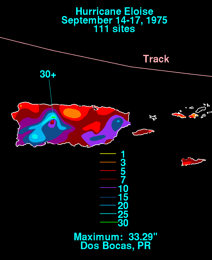
Despite being only a tropical storm while passing by Puerto Rico, Eloise produced extreme amounts of rainfall on the island, peaking at 33.29 inches (845.6 mm) in Dos Bocas. Other totals of 10 to 20 in (254 to 508 mm) were common. The heavy rains resulted in severe flash flooding which killed 34 people, mostly from drownings, and left $60 million in damages. Several hundred people were injured, and the storm forced over 6,000 residents from their homes. Dozens of towns and villages were flooded, though Utuado
, with a population of 35,000 at the time, was hit the hardest. The situation in that town was described as a "total disaster"; four housing developments were under water, and dozens of vehicles were washed away. The flood waters submerged thousands of miles of roads and put several bridges out-of-service.
As the storm proceeded westward, it dropped heavy rainfall throughout eastern and southern Hispaniola. Widespread flooding impacted Haiti and the Dominican Republic, leaving a total of 25 people dead. Although the most intense winds remained offshore, a gust of 50 mph (80.5 km/h) was recorded at Cape Engaño
. Puerto Plata
on the northern coast of the Dominican Republic was also battered by high winds and heavy rain. Following the storm, electricity was turned off due to the danger of electrocutions.
Rain and wind from the storm affected the southern Bahamas, Cuba, Jamaica
, the Cayman Islands
, and the northern Yucatan Peninsula. Since the storm was primarily weak while passing by these areas, no significant damage was reported. Eloise brought torrential rainfall and winds of 20 mph (32.2 km/h) to the Guantanamo Bay Naval Base
in southeastern Cuba, inflicting $65,000 in damage. Personnel on the base were moved to designated hurricane shelters in advance of the storm.
through Panama City. Along the coast, tides ran 12 to 16 ft (3.7 to 4.9 m) above normal, peaking at 18 ft (5.5 m). Hurricane Eloise spawned several tornadoes as it pressed inland. In general, rainfall ranged from 4 to 8 in (101.6 to 203.2 mm); at the Eglin Air Force Base
near Valparaiso
, however, the hurricane dropped 14.9 in (378.5 mm) of precipitation. The heaviest rainfall was usually confined to northwest of the storm's track, and a number of locations to the east of Eloise's center picked up less than 1 in (25.4 mm) of rain.
Damage from the hurricane was widespread. Fort Walton Beach, where hundreds of structures were damaged or destroyed, was hit particularly hard. In some areas, the storm surge washed away buildings demolished by the strong winds. The winds cleared certain locations of trees and buried properties and roads under sand. Throughout northwest Florida, an estimated 8,000 people suffered storm-related losses, and 500 businesses were completely destroyed. An article in the Tallahassee Democrat
reported that "Cottages, motels, restaurants, convenience stores and other beach businesses were strewn across the highway in a tangle of down power poles, lines and busted mains." A 2100 acres (8.5 km²) shrimp farm at Panama City, the first of its kind, was effectively lost. The storm destroyed the farm's prospective initial harvest, 1500000 pounds (680,388.6 kg) of shrimp enclosed in a system of nets and enclosures. The president of the company described the subsequent events as six months of extreme turmoil in an effort to recover, followed by a quick and steady rebound. By the spring of 1976, the company became confident in financial success and full recovery.
The storm caused severe beach erosion in Bay County
; approximately 801000 cubic yards (612,408.4 m³) of sand was removed. Storm-related changes in the coastal topography resulted in extensive structural damage in the Panama City Beach
area. The most severe damage was concentrated in a 22 mi (35.4 km) area of the shore east of the hurricane's eye, and storm surge peaked in intensity for no more than a half hour according to preliminary estimates. Much of the resultant damage came as a result of foundation undermining, which was compared to that of the New England hurricane of 1938
. Although Eloise was not abnormally strong, the geographicy setting and building standards in the area were blamed for the destruction of many homes and businesses. Monetary losses from property damage in Panama City Beach alone totaled about $50 million.
The first major storm to strike the region in 40 years, Hurricane Eloise did not directly kill anyone in the state of Florida. However, four deaths of an indirect nature were attributed to the hurricane; two of them were related to heart attacks. Numerous people sustained injuries, largely from broken glass or cleanup efforts. Overall property damage from the storm in Florida amounted to $150 million. In the storm's aftermath, a study of the hurricane's effect on aquatic animals living in the swash zone (the immediate area where land and the ocean meet) of Panama City Beach was conducted. The study concluded that compared to 11 consecutive months of data prior to the storm, the swash zone experienced a brief influx of animal species normally found offshore. However, the number decreased to near normal shortly thereafter. Also along the shore, the hurricane dismantled or severely impaired several piers, including the total destruction of a 300 ft (91.4 m) extension of the Okaloosa Island
Pier built just three years earlier and part of its original span. A fishing pier at St. Andrews State Park also suffered vast damage, along with another wooden pier at Mexico Beach
and the M.B. Miller Pier at Panama City Beach, which lost its end section to the storm.
. Winds elsewhere in the state ranged from around 35 mph (56.3 km/h) to 88 mph (141.6 km/h). Precipitation in Alabama peaked at 5.54 in (140.7 mm). The high winds resulted in severe damage to property and crops, amounting to $100 million. Eloise cut power and telephone service in the area, and in Geneva County
, several people sustained storm-related injuries. As in Florida, the weakening hurricane spawned a number of tornadoes in Alabama and Georgia. Preliminary reports indicated that every county in southeastern Alabama received some damage from the storm. The strong winds uprooted trees and knocked down powerlines. Heavy rain associated with the storm caused a leak in the Alabama State Capitol
building roof. Gusty winds, moderate to heavy rainfall, and low pressures extended into Georgia, Louisiana, and to a lesser extent, Mississippi
.
 The remnants of Eloise interacted with another weather system, producing widespread precipitation across the Eastern United States, including portions of the Ohio Valley, the Mid-Atlantic states
, and New England
. The deluge was "almost continuous" during the period between September 22 and 26 according to a statement by the National Weather Service. One of the highest rainfall totals in association with the storm occurred in Westminster, Maryland
, where 14.23 in (361.4 mm) of rain was recorded. Elsewhere, 7 inch or more of precipitation fell throughout parts of Pennsylvania
, New Jersey
, New York
and Connecticut
. At least 22 states received rainfall from Hurricane Eloise and its remnant moisture. Nearby Hurricane Faye may have also contributed to the heavy rainfall, although this connection was never confirmed. In Washington, D.C.
, 9.08 in (230.6 mm) of rain contributed to the wettest September on record since 1934. The excessive rainfall led to extensive flooding throughout the region, in some areas exceeding 50- to 100-year levels.
Pennsylvania and New York bore the brunt of the flooding, which culminated in loss of life and severe property damage. Along the central Southern Tier
region of New York, the storm damaged or destroyed over 700 structures. Flooding throughout the Northeastern United States disabled over a dozen water plants and at least 16 sewage treatment plants, prompting a boil-water advisory in Pennsylvania's capital city of Harrisburg
. Infrastructure further south also suffered; in Maryland
, the Monocacy River
—a tributary of the Potomac
—swelled to 14 ft (4.3 m) above flood stage, inundating the city of Frederick
and compromising the city's supply of fresh drinking water. A final downpour of rain on the night of September 25–26 led to an additional 4 in (101.6 mm) of rain in central Maryland triggered severe flash flooding. In some cases, this onslaught affected the same areas that were still recovering from Hurricane Agnes
several years earlier, including Ellicott City
, Elkridge
, and Laurel
, where two major rivers breached their banks and engulfed nearby areas. Many homes and businesses were lost, along with numerous vehicles; in the aftermath, looters entered on boats to access the devastated cities. The floodgates at the Rocky Gorge Dam
in Laural were opened, forcing 500 residents downstream to leave their homes.
The consequences of the flooding rains were the worst seen in areas of the interior Mid-Atlantic states since Agnes, and comparisons were often drawn between the two hurricanes. In Pennsylvania alone, flooding from the remnants of Eloise forced 20,000 residents out of their homes; thousands further south in the Washington, D.C. area, where severe flooding impacted the city's southern suburbs, also fled to seek refuge. Further, many motorists throughout the region became stranded on highways inundated by floodwaters. Four Mile Run
and nearby streams overflowed and "tumbled through residential neighborhoods". Hundreds of families in the Alexandria
and Arlington, Virginia area suffered flood-related losses. Across the Northeastern U.S., the storm system killed 17 people and inflicted $300 million in damage. An instance of a storm-induced fatality is the death of a man in White Plains, New York
, who was killed by waters raging across the Hutchinson River Parkway
. Agriculturally, the extended period of wet weather threatened a range of crops, including the Rhode Island
apple crop, of which 35% was feared to have been destroyed, and corn and sweet potato fields in North Carolina
. With ground too moist for farm machinery to operate on, harvests were postponed.
. In 1995, reports from the aftermath of Hurricane Opal
created a more extensive collection of data.
On September 26, President Gerald Ford
approved the declaration for Florida, and later issued a separate declaration for 30 counties in Pennsylvania as the storm's flooding rains progressed northward. Pennsylvania Lieutenant Governor Ernest Kline assigned 600 National Guardsmen to assist in the evacuation of flood victims and maintain security in storm-ravaged areas. Over $430 million in federal disaster relief was spent overall in 1975 and distributed to 92,000 families; the bulk of the funds went to recovery for areas affected by Hurricane Eloise along its entire course. In Maryland, Governor Marvin Mandel
placed 10 of the state's 23 counties under a state of emergency. Following the severe damage caused by Hurricane Eloise, its name was retired at the end of the 1975 season. As such, the name was removed from the rotating lists of names used in the Atlantic hurricane basin. However, Eloise was not replaced by any particular name due to the addition of male names into the lists in 1979.
Tropical cyclone
A tropical cyclone is a storm system characterized by a large low-pressure center and numerous thunderstorms that produce strong winds and heavy rain. Tropical cyclones strengthen when water evaporated from the ocean is released as the saturated air rises, resulting in condensation of water vapor...
of the 1975 Atlantic hurricane season
1975 Atlantic hurricane season
The 1975 Atlantic hurricane season officially began on June 1, 1975, and lasted until November 30, 1975. These dates conventionally delimit the period of each year when most tropical cyclones form in the Atlantic basin...
. The fifth tropical storm, fourth hurricane, and second major hurricane of the season, Eloise formed as a tropical depression on September 13 to the east of the Virgin Islands
Virgin Islands
The Virgin Islands are the western island group of the Leeward Islands, which are the northern part of the Lesser Antilles, which form the border between the Caribbean Sea and the Atlantic Ocean...
. The depression tracked westward as it intensified into a tropical storm and after passing to the north of Puerto Rico
Puerto Rico
Puerto Rico , officially the Commonwealth of Puerto Rico , is an unincorporated territory of the United States, located in the northeastern Caribbean, east of the Dominican Republic and west of both the United States Virgin Islands and the British Virgin Islands.Puerto Rico comprises an...
, Eloise briefly attained hurricane intensity. However, the storm made landfall on Hispaniola
Hispaniola
Hispaniola is a major island in the Caribbean, containing the two sovereign states of the Dominican Republic and Haiti. The island is located between the islands of Cuba to the west and Puerto Rico to the east, within the hurricane belt...
, causing it to weaken back into a tropical storm. A weak and disorganized cyclone, Eloise emerged into open waters of the northern Caribbean Sea, and upon striking the northern Yucatan Peninsula
Yucatán Peninsula
The Yucatán Peninsula, in southeastern Mexico, separates the Caribbean Sea from the Gulf of Mexico, with the northern coastline on the Yucatán Channel...
, it turned north and began to re-intensify. In the Gulf of Mexico, the system quickly developed and became a Category 3 hurricane on the Saffir-Simpson Hurricane Scale
Saffir-Simpson Hurricane Scale
The Saffir–Simpson Hurricane Scale , or the Saffir–Simpson Hurricane Wind Scale , classifies hurricanes — Western Hemisphere tropical cyclones that exceed the intensities of tropical depressions and tropical storms — into five categories distinguished by the intensities of their sustained winds...
on September 23. Eloise made landfall along the Florida Panhandle
Florida Panhandle
The Florida Panhandle, an informal, unofficial term for the northwestern part of Florida, is a strip of land roughly 200 miles long and 50 to 100 miles wide , lying between Alabama on the north and the west, Georgia also on the north, and the Gulf of Mexico to the south. Its eastern boundary is...
west of Panama City
Panama City, Florida
-Personal income:The median income for a household in the city was $31,572, and the median income for a family was $40,890. Males had a median income of $30,401 versus $21,431 for females. The per capita income for the city was $17,830...
before moving inland across Alabama
Alabama
Alabama is a state located in the southeastern region of the United States. It is bordered by Tennessee to the north, Georgia to the east, Florida and the Gulf of Mexico to the south, and Mississippi to the west. Alabama ranks 30th in total land area and ranks second in the size of its inland...
and eventually dissipating on September 24.
The storm produced torrential rainfall throughout Puerto Rico and Hispaniola, causing extensive flooding, over 40 deaths, and severe damage. Thousands in these areas were left homeless. As Eloise progressed westward, it affected Cuba to a lesser extent. In advance of the storm, about 100,000 residents evacuated from the Gulf Coast region. Upon making landfall in Florida, Eloise generated winds reportedly gusting to 155 mph (249.4 km/h), which caused extreme damage throughout the area. Hundreds of buildings were demolished by the powerful winds and strong storm surge. Across the United States, damage amounted to approximately $560 million. The storm killed 80 people along its track, and due to the severe damage, the name "Eloise" was retired from the list of Atlantic tropical cyclone names.
Meteorological history
The origins of Hurricane Eloise trace back to a tropical waveTropical wave
Tropical waves, easterly waves, or tropical easterly waves, also known as African easterly waves in the Atlantic region, are a type of atmospheric trough, an elongated area of relatively low air pressure, oriented north to south, which move from east to west across the tropics causing areas of...
that emerged from the western coast of Africa on September 6, 1975. Satellite imagery indicated that the system was initially disjointed and poorly developed, although there was evidence of a low-level circulation. The disturbance tracked westward for several days as it slowly matured. On September 13, a ship called the Gulf Hansa recorded winds of around 25 mph (40.2 km/h) and 10 ft (3 m) seas in association with the system. Shortly thereafter, a reconnaissance aircraft
Reconnaissance aircraft
A reconnaissance aircraft is a manned military aircraft designed, or adapted, to carry out aerial reconnaissance.-History:The majority of World War I aircraft were reconnaissance designs...
found a center of circulation 575 mi (925.4 km) east of the Virgin Islands
Virgin Islands
The Virgin Islands are the western island group of the Leeward Islands, which are the northern part of the Lesser Antilles, which form the border between the Caribbean Sea and the Atlantic Ocean...
, and it is estimated that the storm became a tropical depression at 0600 UTC.
The depression continued moving towards the west as it gradually strengthened. On September 16, the system attained tropical storm status and was designated Eloise; accordingly, the first advisory on the system was issued by the San Juan Weather Bureau office. While in the vicinity of a strengthening anticyclone
Anticyclone
An anticyclone is a weather phenomenon defined by the United States' National Weather Service's glossary as "[a] large-scale circulation of winds around a central region of high atmospheric pressure, clockwise in the Northern Hemisphere, counterclockwise in the Southern Hemisphere"...
aloft, Eloise became better organized, and the storm rapidly intensified and reached Category 1 hurricane status 18 hours after being named. The cyclone soon made landfall on the Dominican Republic
Dominican Republic
The Dominican Republic is a nation on the island of La Hispaniola, part of the Greater Antilles archipelago in the Caribbean region. The western third of the island is occupied by the nation of Haiti, making Hispaniola one of two Caribbean islands that are shared by two countries...
, inhibiting further development. Although initially predicted to remain north of land, the storm moved across northern Hispaniola and then tracked across southeastern Cuba
Cuba
The Republic of Cuba is an island nation in the Caribbean. The nation of Cuba consists of the main island of Cuba, the Isla de la Juventud, and several archipelagos. Havana is the largest city in Cuba and the country's capital. Santiago de Cuba is the second largest city...
. After 36 hours with much of its circulation over mountainous terrain, Eloise deteriorated to a tropical storm on September 17.
The cyclone emerged over the open waters of the northern Caribbean on September 19, passing Jamaica
Jamaica
Jamaica is an island nation of the Greater Antilles, in length, up to in width and 10,990 square kilometres in area. It is situated in the Caribbean Sea, about south of Cuba, and west of Hispaniola, the island harbouring the nation-states Haiti and the Dominican Republic...
to the north as it moved away from Cuba. Despite favorable upper-level conditions, its interaction with land—combined with the weakening of a ridge
Ridge (meteorology)
A ridge is an elongated region of relatively high atmospheric pressure, the opposite of a trough....
to the north—left the storm's center distorted. Eloise remained a fairly disorganized tropical storm until September 20, when it approached the Yucatan Peninsula
Yucatán Peninsula
The Yucatán Peninsula, in southeastern Mexico, separates the Caribbean Sea from the Gulf of Mexico, with the northern coastline on the Yucatán Channel...
and began to re-intensify. The storm crossed over the northern tip of the peninsula as it began to turn northward in response to an approaching trough
Trough (meteorology)
A trough is an elongated region of relatively low atmospheric pressure, often associated with fronts.Unlike fronts, there is not a universal symbol for a trough on a weather chart. The weather charts in some countries or regions mark troughs by a line. In the United States, a trough may be marked...
. Between September 17 and September 21, however, reports on the storm were scarce, leading to uncertainty in its exact location and strength. Upon entering the Gulf of Mexico
Gulf of Mexico
The Gulf of Mexico is a partially landlocked ocean basin largely surrounded by the North American continent and the island of Cuba. It is bounded on the northeast, north and northwest by the Gulf Coast of the United States, on the southwest and south by Mexico, and on the southeast by Cuba. In...
, Eloise quickly organized. The trough enhanced the wind divergence over the storm's center, allowing it to strengthen once again to reach hurricane force about 345 mi (555.2 km) south of New Orleans, Louisiana
Louisiana
Louisiana is a state located in the southern region of the United States of America. Its capital is Baton Rouge and largest city is New Orleans. Louisiana is the only state in the U.S. with political subdivisions termed parishes, which are local governments equivalent to counties...
.
Florida Panhandle
The Florida Panhandle, an informal, unofficial term for the northwestern part of Florida, is a strip of land roughly 200 miles long and 50 to 100 miles wide , lying between Alabama on the north and the west, Georgia also on the north, and the Gulf of Mexico to the south. Its eastern boundary is...
near Panama City
Panama City, Florida
-Personal income:The median income for a household in the city was $31,572, and the median income for a family was $40,890. Males had a median income of $30,401 versus $21,431 for females. The per capita income for the city was $17,830...
on September 23. Shortly after making landfall, the hurricane rapidly degenerated. Just six hours later, it had weakened into a tropical storm, while situated over eastern Alabama
Alabama
Alabama is a state located in the southeastern region of the United States. It is bordered by Tennessee to the north, Georgia to the east, Florida and the Gulf of Mexico to the south, and Mississippi to the west. Alabama ranks 30th in total land area and ranks second in the size of its inland...
. It further weakened into a tropical depression at 0000 UTC on September 24. The depression transitioned into an extratropical storm over Virginia
Virginia
The Commonwealth of Virginia , is a U.S. state on the Atlantic Coast of the Southern United States. Virginia is nicknamed the "Old Dominion" and sometimes the "Mother of Presidents" after the eight U.S. presidents born there...
, and became indistinguishable by later that same day. The remnant moisture, however, merged with a weather front
Weather front
A weather front is a boundary separating two masses of air of different densities, and is the principal cause of meteorological phenomena. In surface weather analyses, fronts are depicted using various colored lines and symbols, depending on the type of front...
to produce widespread and heavy precipitation.
Preparations
In advance of Hurricane Eloise, warnings for heavy rainfall and potential flooding were issued for Puerto RicoPuerto Rico
Puerto Rico , officially the Commonwealth of Puerto Rico , is an unincorporated territory of the United States, located in the northeastern Caribbean, east of the Dominican Republic and west of both the United States Virgin Islands and the British Virgin Islands.Puerto Rico comprises an...
and the Virgin Islands. A hurricane warning was declared for parts of the Dominican Republic about 12 hours before landfall. A "hurricane emergency" was put into effect for the Oriente Province of Cuba, while a "state of alert" was issued for the Camagüey Province
Camagüey Province
Camagüey is the largest of the provinces of Cuba. Its capital is Camagüey. Other towns include Florida and Nuevitas.-Geography:Camagüey is mostly low lying, with no major hills or mountain ranges passing through the province...
. Cubana de Aviación
Cubana de Aviación
Cubana de Aviación S.A., commonly known as Cubana, is Cuba's largest airline and flag carrier. The airline was founded on 8 October 1929, and has its corporate headquarters in Havana. Its main base is at José Martí International Airport...
suspended all flights to Oriente.
On and before September 15, there was still uncertainty as to whether Eloise would impact the United States. However, officials in Florida began taking precautionary measures. When the storm entered the Gulf of Mexico, forecasters suggested that the storm would continue northward and strike the area near Mobile Bay
Mobile Bay
Mobile Bay is an inlet of the Gulf of Mexico, lying within the state of Alabama in the United States. Its mouth is formed by the Fort Morgan Peninsula on the eastern side and Dauphin Island, a barrier island on the western side. The Mobile River and Tensaw River empty into the northern end of the...
. Contrary to predictions, by late on September 22, the storm had turned northeast, and some residents of Florida were still unaware of the storm's threat despite the issuance of hurricane warnings 24 hours in advance. As a result, evacuations were delayed to an extent. During the morning hours of September 23, civil preparedness workers drove through coastal towns with loudspeakers advising people to seek shelter. Due of the intensity of the approaching hurricane, evacuations along the coast were ultimately thorough, despite the initial delay. It was reported that 99% of Pensacola
Pensacola, Florida
Pensacola is the westernmost city in the Florida Panhandle and the county seat of Escambia County, Florida, United States of America. As of the 2000 census, the city had a total population of 56,255 and as of 2009, the estimated population was 53,752...
residents along the beach had left their homes, and overall, 100,000 people evacuated from areas in Louisiana through Florida.
A statement issued by the National Weather Service
National Weather Service
The National Weather Service , once known as the Weather Bureau, is one of the six scientific agencies that make up the National Oceanic and Atmospheric Administration of the United States government...
urged people in nine Florida counties to complete preparations for the hurricane. Residents were told to secure loose objects and move watercraft to safe harbors. Homes along the coast were boarded up by their owners, while offshore, workers were removed from oil platforms. A spokesman for Royal Dutch Shell
Royal Dutch Shell
Royal Dutch Shell plc , commonly known as Shell, is a global oil and gas company headquartered in The Hague, Netherlands and with its registered office in London, United Kingdom. It is the fifth-largest company in the world according to a composite measure by Forbes magazine and one of the six...
reported that 800 workers were to be evacuated. In New Orleans, emergency equipment was readied and inspected. The New Orleans Levee Board went into a second-stage alert on September 21, and cleared debris from floodwall openings.
Caribbean Sea
| Region | Direct deaths |
|---|---|
| Puerto Rico Puerto Rico Puerto Rico , officially the Commonwealth of Puerto Rico , is an unincorporated territory of the United States, located in the northeastern Caribbean, east of the Dominican Republic and west of both the United States Virgin Islands and the British Virgin Islands.Puerto Rico comprises an... |
34 |
| Dominican Republic Dominican Republic The Dominican Republic is a nation on the island of La Hispaniola, part of the Greater Antilles archipelago in the Caribbean region. The western third of the island is occupied by the nation of Haiti, making Hispaniola one of two Caribbean islands that are shared by two countries... |
7 |
| Haiti Haiti Haiti , officially the Republic of Haiti , is a Caribbean country. It occupies the western, smaller portion of the island of Hispaniola, in the Greater Antillean archipelago, which it shares with the Dominican Republic. Ayiti was the indigenous Taíno or Amerindian name for the island... |
18 |
| Florida Florida Florida is a state in the southeastern United States, located on the nation's Atlantic and Gulf coasts. It is bordered to the west by the Gulf of Mexico, to the north by Alabama and Georgia and to the east by the Atlantic Ocean. With a population of 18,801,310 as measured by the 2010 census, it... |
4 |
| United States United States The United States of America is a federal constitutional republic comprising fifty states and a federal district... , elsewhere |
17 |
| Total | 80 |
As a weak tropical depression, the storm brought 5 to 10 in (127 to 254 mm) of rainfall to portions of the Leeward Islands
Leeward Islands
The Leeward Islands are a group of islands in the West Indies. They are the northern islands of the Lesser Antilles chain. As a group they start east of Puerto Rico and reach southward to Dominica. They are situated where the northeastern Caribbean Sea meets the western Atlantic Ocean...
, including St. Kitts and St. Martin. Lighter precipitation fell on the more northern islands. Winds were light in these areas.
Despite being only a tropical storm while passing by Puerto Rico, Eloise produced extreme amounts of rainfall on the island, peaking at 33.29 inches (845.6 mm) in Dos Bocas. Other totals of 10 to 20 in (254 to 508 mm) were common. The heavy rains resulted in severe flash flooding which killed 34 people, mostly from drownings, and left $60 million in damages. Several hundred people were injured, and the storm forced over 6,000 residents from their homes. Dozens of towns and villages were flooded, though Utuado
Utuado, Puerto Rico
Utuado is a municipality of Puerto Rico located in the central-western mountainous region of the island known as La Cordillera Central. It is located north of Adjuntas and Ponce; south of Hatillo and Arecibo; east of Lares; and west of Ciales and Jayuya. In land area it is the third-largest...
, with a population of 35,000 at the time, was hit the hardest. The situation in that town was described as a "total disaster"; four housing developments were under water, and dozens of vehicles were washed away. The flood waters submerged thousands of miles of roads and put several bridges out-of-service.
As the storm proceeded westward, it dropped heavy rainfall throughout eastern and southern Hispaniola. Widespread flooding impacted Haiti and the Dominican Republic, leaving a total of 25 people dead. Although the most intense winds remained offshore, a gust of 50 mph (80.5 km/h) was recorded at Cape Engaño
Cape Engaño (Dominican Republic)
Cape Engaño is a cape containing dangerous reefs near Santo Domingo in the Dominican Republic....
. Puerto Plata
San Felipe de Puerto Plata
San Felipe de Puerto Plata, often referred to as simply Puerto Plata, is the capital of the Dominican province Puerto Plata.The city is famous for resorts such as Playa Dorada and Costa Dorada, located east of San Felipe de Puerto Plata. There are a total of 100,000 hotel beds in the city.The only...
on the northern coast of the Dominican Republic was also battered by high winds and heavy rain. Following the storm, electricity was turned off due to the danger of electrocutions.
Rain and wind from the storm affected the southern Bahamas, Cuba, Jamaica
Jamaica
Jamaica is an island nation of the Greater Antilles, in length, up to in width and 10,990 square kilometres in area. It is situated in the Caribbean Sea, about south of Cuba, and west of Hispaniola, the island harbouring the nation-states Haiti and the Dominican Republic...
, the Cayman Islands
Cayman Islands
The Cayman Islands is a British Overseas Territory and overseas territory of the European Union located in the western Caribbean Sea. The territory comprises the three islands of Grand Cayman, Cayman Brac, and Little Cayman, located south of Cuba and northwest of Jamaica...
, and the northern Yucatan Peninsula. Since the storm was primarily weak while passing by these areas, no significant damage was reported. Eloise brought torrential rainfall and winds of 20 mph (32.2 km/h) to the Guantanamo Bay Naval Base
Guantanamo Bay Naval Base
Guantanamo Bay Naval Base is located on of land and water at Guantánamo Bay, Cuba which the United States leased for use as a coaling station following the Cuban-American Treaty of 1903. The base is located on the shore of Guantánamo Bay at the southeastern end of Cuba. It is the oldest overseas...
in southeastern Cuba, inflicting $65,000 in damage. Personnel on the base were moved to designated hurricane shelters in advance of the storm.
Florida
Eloise came ashore along the coast of northern Florida as a Category 3 storm producing winds of 90 mph (144.8 km/h) with gusts that reached 155 mph (249.4 km/h). Sustained winds were likely higher, but due to the sparsity of recording stations, few official records exist. The winds in the area were reportedly the strongest of the century. Hurricane-force winds occurred from Fort Walton BeachFort Walton Beach, Florida
Fort Walton Beach is a city in southern Okaloosa County, Florida, United States. As of 2005, the population estimate for Fort Walton Beach was 19,992, and as of 2010, the population estimate for Fort Walton Beach is 19,507 recorded by the U.S. Census Bureau...
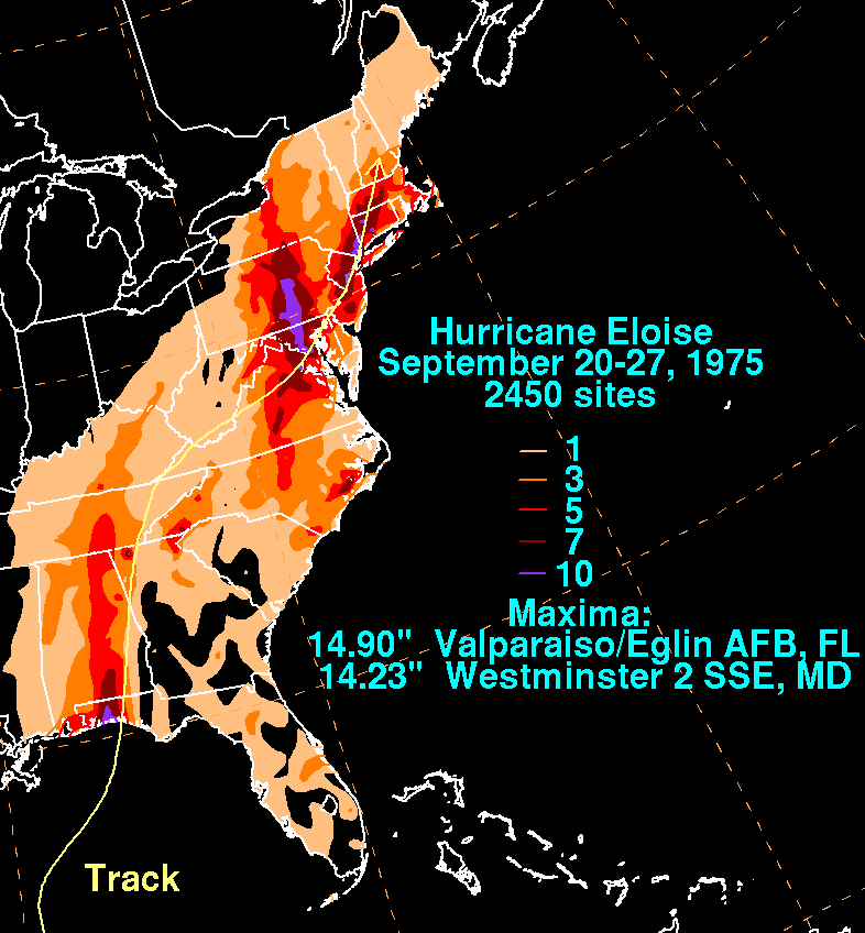
through Panama City. Along the coast, tides ran 12 to 16 ft (3.7 to 4.9 m) above normal, peaking at 18 ft (5.5 m). Hurricane Eloise spawned several tornadoes as it pressed inland. In general, rainfall ranged from 4 to 8 in (101.6 to 203.2 mm); at the Eglin Air Force Base
Eglin Air Force Base
Eglin Air Force Base is a United States Air Force base located approximately 3 miles southwest of Valparaiso, Florida in Okaloosa County....
near Valparaiso
Valparaiso, Florida
Valparaiso is a city in Okaloosa County, Florida, in the United States, and it is named after the Chilean city of Valparaiso. As of the 2000 census, the city population was 6,408. According to the U.S. Census Bureau's 2004 estimates, the city had a population of 6,336...
, however, the hurricane dropped 14.9 in (378.5 mm) of precipitation. The heaviest rainfall was usually confined to northwest of the storm's track, and a number of locations to the east of Eloise's center picked up less than 1 in (25.4 mm) of rain.
Damage from the hurricane was widespread. Fort Walton Beach, where hundreds of structures were damaged or destroyed, was hit particularly hard. In some areas, the storm surge washed away buildings demolished by the strong winds. The winds cleared certain locations of trees and buried properties and roads under sand. Throughout northwest Florida, an estimated 8,000 people suffered storm-related losses, and 500 businesses were completely destroyed. An article in the Tallahassee Democrat
Tallahassee Democrat
The Tallahassee Democrat is a daily broadsheet newspaper. It covers the area centered around Tallahassee in Leon County, Florida, as well as adjacent Gadsden County, Jefferson County, and Wakulla County...
reported that "Cottages, motels, restaurants, convenience stores and other beach businesses were strewn across the highway in a tangle of down power poles, lines and busted mains." A 2100 acres (8.5 km²) shrimp farm at Panama City, the first of its kind, was effectively lost. The storm destroyed the farm's prospective initial harvest, 1500000 pounds (680,388.6 kg) of shrimp enclosed in a system of nets and enclosures. The president of the company described the subsequent events as six months of extreme turmoil in an effort to recover, followed by a quick and steady rebound. By the spring of 1976, the company became confident in financial success and full recovery.
The storm caused severe beach erosion in Bay County
Bay County, Florida
Bay County is a county located in the U.S. state of Florida. The U.S. Census Bureau 2006 estimate for the county is 163,505 . Its county seat is Panama City, Florida. The county is best known for its white sand beaches and crystal blue water, where large pods of dolphins swim year-round...
; approximately 801000 cubic yards (612,408.4 m³) of sand was removed. Storm-related changes in the coastal topography resulted in extensive structural damage in the Panama City Beach
Panama City Beach, Florida
Panama City Beach is a city in Bay County, Florida, United States, on the Gulf of Mexico coast. The city is often referred to under the umbrella term of "Panama City", despite being a distinct municipality from the older and larger inland Panama City to the east, making Panama City and Panama City...
area. The most severe damage was concentrated in a 22 mi (35.4 km) area of the shore east of the hurricane's eye, and storm surge peaked in intensity for no more than a half hour according to preliminary estimates. Much of the resultant damage came as a result of foundation undermining, which was compared to that of the New England hurricane of 1938
New England Hurricane of 1938
The New England Hurricane of 1938 was the first major hurricane to strike New England since 1869...
. Although Eloise was not abnormally strong, the geographicy setting and building standards in the area were blamed for the destruction of many homes and businesses. Monetary losses from property damage in Panama City Beach alone totaled about $50 million.
The first major storm to strike the region in 40 years, Hurricane Eloise did not directly kill anyone in the state of Florida. However, four deaths of an indirect nature were attributed to the hurricane; two of them were related to heart attacks. Numerous people sustained injuries, largely from broken glass or cleanup efforts. Overall property damage from the storm in Florida amounted to $150 million. In the storm's aftermath, a study of the hurricane's effect on aquatic animals living in the swash zone (the immediate area where land and the ocean meet) of Panama City Beach was conducted. The study concluded that compared to 11 consecutive months of data prior to the storm, the swash zone experienced a brief influx of animal species normally found offshore. However, the number decreased to near normal shortly thereafter. Also along the shore, the hurricane dismantled or severely impaired several piers, including the total destruction of a 300 ft (91.4 m) extension of the Okaloosa Island
Okaloosa Island
Okaloosa Island is a regionally used term for a small section of larger Santa Rosa Island located in Okaloosa County, Florida. Okaloosa Island is home to hundreds of residential homes, high rise condominiums and major hotels and motels. The area is unincorporated and uses Fort Walton Beach as a...
Pier built just three years earlier and part of its original span. A fishing pier at St. Andrews State Park also suffered vast damage, along with another wooden pier at Mexico Beach
Mexico Beach, Florida
Mexico Beach is a city in Bay County, Florida, United States. The population was 1,072 at the 2010 census. . It is part of the Panama City–Lynn Haven–Panama City Beach Metropolitan Statistical Area.-Geography:Mexico Beach is located at ....
and the M.B. Miller Pier at Panama City Beach, which lost its end section to the storm.
Elsewhere in the United States
As the hurricane progressed inland, it passed over eastern Alabama, generating strong winds. A gust of 100 mph (160.9 km/h) was recorded northeast of OzarkOzark, Alabama
Ozark is a city in and the county seat of Dale County, Alabama, United States. In 1990 the city population was 12,922. As of the 2000 census, the population of the city was 15,119....
. Winds elsewhere in the state ranged from around 35 mph (56.3 km/h) to 88 mph (141.6 km/h). Precipitation in Alabama peaked at 5.54 in (140.7 mm). The high winds resulted in severe damage to property and crops, amounting to $100 million. Eloise cut power and telephone service in the area, and in Geneva County
Geneva County, Alabama
-2010:Whereas according to the 2010 U.S. Census Bureau:*86.3% White*9.5% Black*0.8% Native American*0.3% Asian*0.0% Native Hawaiian or Pacific Islander*1.6% Two or more races*3.4% Hispanic or Latino -2000:...
, several people sustained storm-related injuries. As in Florida, the weakening hurricane spawned a number of tornadoes in Alabama and Georgia. Preliminary reports indicated that every county in southeastern Alabama received some damage from the storm. The strong winds uprooted trees and knocked down powerlines. Heavy rain associated with the storm caused a leak in the Alabama State Capitol
Alabama State Capitol
The Alabama State Capitol, also known as the First Confederate Capitol, is the state capitol building for Alabama. It is located on Capitol Hill, originally Goat Hill, in Montgomery. It was declared a National Historic Landmark on December 19, 1960....
building roof. Gusty winds, moderate to heavy rainfall, and low pressures extended into Georgia, Louisiana, and to a lesser extent, Mississippi
Mississippi
Mississippi is a U.S. state located in the Southern United States. Jackson is the state capital and largest city. The name of the state derives from the Mississippi River, which flows along its western boundary, whose name comes from the Ojibwe word misi-ziibi...
.
Mid-Atlantic States
The Mid-Atlantic states, also called middle Atlantic states or simply the mid Atlantic, form a region of the United States generally located between New England and the South...
, and New England
New England
New England is a region in the northeastern corner of the United States consisting of the six states of Maine, New Hampshire, Vermont, Massachusetts, Rhode Island, and Connecticut...
. The deluge was "almost continuous" during the period between September 22 and 26 according to a statement by the National Weather Service. One of the highest rainfall totals in association with the storm occurred in Westminster, Maryland
Westminster, Maryland
Westminster is a city in northern Maryland, United States. It is the seat of Carroll County. The city's population was 18,590 at the 2010 census. Westminster is an outlying community within the Baltimore-Towson, MD MSA, which is part of a greater Washington-Baltimore-Northern Virginia, DC-MD-VA-WV...
, where 14.23 in (361.4 mm) of rain was recorded. Elsewhere, 7 inch or more of precipitation fell throughout parts of Pennsylvania
Pennsylvania
The Commonwealth of Pennsylvania is a U.S. state that is located in the Northeastern and Mid-Atlantic regions of the United States. The state borders Delaware and Maryland to the south, West Virginia to the southwest, Ohio to the west, New York and Ontario, Canada, to the north, and New Jersey to...
, New Jersey
New Jersey
New Jersey is a state in the Northeastern and Middle Atlantic regions of the United States. , its population was 8,791,894. It is bordered on the north and east by the state of New York, on the southeast and south by the Atlantic Ocean, on the west by Pennsylvania and on the southwest by Delaware...
, New York
New York
New York is a state in the Northeastern region of the United States. It is the nation's third most populous state. New York is bordered by New Jersey and Pennsylvania to the south, and by Connecticut, Massachusetts and Vermont to the east...
and Connecticut
Connecticut
Connecticut is a state in the New England region of the northeastern United States. It is bordered by Rhode Island to the east, Massachusetts to the north, and the state of New York to the west and the south .Connecticut is named for the Connecticut River, the major U.S. river that approximately...
. At least 22 states received rainfall from Hurricane Eloise and its remnant moisture. Nearby Hurricane Faye may have also contributed to the heavy rainfall, although this connection was never confirmed. In Washington, D.C.
Washington, D.C.
Washington, D.C., formally the District of Columbia and commonly referred to as Washington, "the District", or simply D.C., is the capital of the United States. On July 16, 1790, the United States Congress approved the creation of a permanent national capital as permitted by the U.S. Constitution....
, 9.08 in (230.6 mm) of rain contributed to the wettest September on record since 1934. The excessive rainfall led to extensive flooding throughout the region, in some areas exceeding 50- to 100-year levels.
Pennsylvania and New York bore the brunt of the flooding, which culminated in loss of life and severe property damage. Along the central Southern Tier
Southern Tier
The Southern Tier is a geographical term that refers to the counties of New York State west of the Catskill Mountains along the northern border of Pennsylvania. It is a loosely defined term that generally includes the counties that border Pennsylvania west of Delaware County inclusive...
region of New York, the storm damaged or destroyed over 700 structures. Flooding throughout the Northeastern United States disabled over a dozen water plants and at least 16 sewage treatment plants, prompting a boil-water advisory in Pennsylvania's capital city of Harrisburg
Harrisburg, Pennsylvania
Harrisburg is the capital of Pennsylvania. As of the 2010 census, the city had a population of 49,528, making it the ninth largest city in Pennsylvania...
. Infrastructure further south also suffered; in Maryland
Maryland
Maryland is a U.S. state located in the Mid Atlantic region of the United States, bordering Virginia, West Virginia, and the District of Columbia to its south and west; Pennsylvania to its north; and Delaware to its east...
, the Monocacy River
Monocacy River
The Monocacy River is a free-flowing tributary of the Potomac River, which empties into the Atlantic Ocean via the Chesapeake Bay. The river is long, with a drainage area of about...
—a tributary of the Potomac
Potomac River
The Potomac River flows into the Chesapeake Bay, located along the mid-Atlantic coast of the United States. The river is approximately long, with a drainage area of about 14,700 square miles...
—swelled to 14 ft (4.3 m) above flood stage, inundating the city of Frederick
Frederick, Maryland
Frederick is a city in north-central Maryland. It is the county seat of Frederick County, the largest county by area in the state of Maryland. Frederick is an outlying community of the Washington-Arlington-Alexandria, DC-VA-MD-WV Metropolitan Statistical Area, which is part of a greater...
and compromising the city's supply of fresh drinking water. A final downpour of rain on the night of September 25–26 led to an additional 4 in (101.6 mm) of rain in central Maryland triggered severe flash flooding. In some cases, this onslaught affected the same areas that were still recovering from Hurricane Agnes
Hurricane Agnes
Hurricane Agnes was the first tropical storm and first hurricane of the 1972 Atlantic hurricane season. A rare June hurricane, it made landfall on the Florida Panhandle before moving northeastward and ravaging the Mid-Atlantic region as a tropical storm...
several years earlier, including Ellicott City
Ellicott City, Maryland
Ellicott City is an unincorporated community and census-designated place in Howard County, Maryland, United States. It is part of the Baltimore-Washington Metropolitan Area. The population was 65,834 at the 2010 census. It is the county seat of Howard County...
, Elkridge
Elkridge, Maryland
Elkridge is a census-designated place in Howard County, Maryland, United States. The population was 22,042 at the 2000 census. Founded early in the 18th century, Elkridge is located at the confluence of three counties, the other two being Anne Arundel and Baltimore counties...
, and Laurel
Laurel, Maryland
Laurel is a city in northern Prince George's County, Anne Arundel County, and Howard County, Maryland, United States, located midway between Washington, D.C. and Baltimore. Incorporated in 1870, the city maintains a historic district including its Main Street...
, where two major rivers breached their banks and engulfed nearby areas. Many homes and businesses were lost, along with numerous vehicles; in the aftermath, looters entered on boats to access the devastated cities. The floodgates at the Rocky Gorge Dam
Rocky Gorge Reservoir
Rocky Gorge Reservoir is located on the Patuxent River in Howard County, Montgomery County and Prince George’s County, Maryland near the town of Burtonsville. The reservoir was created in 1952 by the construction of the T. Howard Duckett Dam on the Patuxent. The dam is visible from Interstate 95...
in Laural were opened, forcing 500 residents downstream to leave their homes.
The consequences of the flooding rains were the worst seen in areas of the interior Mid-Atlantic states since Agnes, and comparisons were often drawn between the two hurricanes. In Pennsylvania alone, flooding from the remnants of Eloise forced 20,000 residents out of their homes; thousands further south in the Washington, D.C. area, where severe flooding impacted the city's southern suburbs, also fled to seek refuge. Further, many motorists throughout the region became stranded on highways inundated by floodwaters. Four Mile Run
Four Mile Run
Four Mile Run is a stream in northern Virginia that starts near Interstate 66, at Gordon Avenue in Fairfax County and proceeds southeast through Falls Church to Arlington County in the U.S. state of Virginia...
and nearby streams overflowed and "tumbled through residential neighborhoods". Hundreds of families in the Alexandria
Alexandria, Virginia
Alexandria is an independent city in the Commonwealth of Virginia. As of 2009, the city had a total population of 139,966. Located along the Western bank of the Potomac River, Alexandria is approximately six miles south of downtown Washington, D.C.Like the rest of northern Virginia, as well as...
and Arlington, Virginia area suffered flood-related losses. Across the Northeastern U.S., the storm system killed 17 people and inflicted $300 million in damage. An instance of a storm-induced fatality is the death of a man in White Plains, New York
White Plains, New York
White Plains is a city and the county seat of Westchester County, New York, United States. It is located in south-central Westchester, about east of the Hudson River and northwest of Long Island Sound...
, who was killed by waters raging across the Hutchinson River Parkway
Hutchinson River Parkway
The Hutchinson River Parkway is a north–south parkway in southern New York, United States. It extends for from the massive Bruckner Interchange in the Throgs Neck section of the Bronx to the New York – Connecticut state line at Rye Brook...
. Agriculturally, the extended period of wet weather threatened a range of crops, including the Rhode Island
Rhode Island
The state of Rhode Island and Providence Plantations, more commonly referred to as Rhode Island , is a state in the New England region of the United States. It is the smallest U.S. state by area...
apple crop, of which 35% was feared to have been destroyed, and corn and sweet potato fields in North Carolina
North Carolina
North Carolina is a state located in the southeastern United States. The state borders South Carolina and Georgia to the south, Tennessee to the west and Virginia to the north. North Carolina contains 100 counties. Its capital is Raleigh, and its largest city is Charlotte...
. With ground too moist for farm machinery to operate on, harvests were postponed.
Aftermath
After touring the disaster area, Florida Governor Reubin Askew noted, "I think we're going to have to take a long, close look at some of the construction [...] Some of the structures simply won't be able to be built back in the exact location where they were." Governor Askew recruited 400 National Guard troops to prevent looting following the storm. He also requested the initial declaration of five counties along the Florida panhandle as national disaster areas, and stated that he would consider adding two more counties. The declaration would make residents in the counties recognized as disaster areas eligible to receive federal aid. Immediately following the storm, the mayor of Panama City criticized the state of Florida for failing to provide sufficient post-storm aid. Despite the destruction, the storm reportedly had some economic benefits; in the midst of rebuilding and recovery, business grew, especially in and around Panama City, and people began to move into the area. In at least one instance, the hurricane and its associated storm surge had a lasting effect on local geography, breaching Crooked Island in Bay County to create an inlet 0.75 mi (1.2 km) wide referred to as Eloise Inlet. Eloise provided a comprehensive base of information on beach and dune erosion along the Florida panhandle, which aided in the programming of certain erosion prediction numerical modelsNumerical weather prediction
Numerical weather prediction uses mathematical models of the atmosphere and oceans to predict the weather based on current weather conditions. Though first attempted in the 1920s, it was not until the advent of computer simulation in the 1950s that numerical weather predictions produced realistic...
. In 1995, reports from the aftermath of Hurricane Opal
Hurricane Opal
Hurricane Opal was a Category 4 hurricane that formed in the Gulf of Mexico in September 1995.Opal was the ninth hurricane and the strongest of the abnormally active 1995 Atlantic hurricane season...
created a more extensive collection of data.
On September 26, President Gerald Ford
Gerald Ford
Gerald Rudolph "Jerry" Ford, Jr. was the 38th President of the United States, serving from 1974 to 1977, and the 40th Vice President of the United States serving from 1973 to 1974...
approved the declaration for Florida, and later issued a separate declaration for 30 counties in Pennsylvania as the storm's flooding rains progressed northward. Pennsylvania Lieutenant Governor Ernest Kline assigned 600 National Guardsmen to assist in the evacuation of flood victims and maintain security in storm-ravaged areas. Over $430 million in federal disaster relief was spent overall in 1975 and distributed to 92,000 families; the bulk of the funds went to recovery for areas affected by Hurricane Eloise along its entire course. In Maryland, Governor Marvin Mandel
Marvin Mandel
Marvin Mandel , a member of the United States Democratic Party, was the 56th Governor of Maryland in the United States from January 7, 1969, to January 17, 1979. He was Maryland's first, and, to date, only Jewish governor.- Early life :...
placed 10 of the state's 23 counties under a state of emergency. Following the severe damage caused by Hurricane Eloise, its name was retired at the end of the 1975 season. As such, the name was removed from the rotating lists of names used in the Atlantic hurricane basin. However, Eloise was not replaced by any particular name due to the addition of male names into the lists in 1979.
See also
- Retired Atlantic hurricane names
- List of Florida hurricanes
- List of Maryland hurricanes (1950–1979)
- List of New York hurricanes
- List of Pennsylvania hurricanes