
.gif)
Unnamed Tropical Storm (1987)
Encyclopedia
The 1987 Gulf Coast tropical storm was the first tropical storm of the below-average 1987
Atlantic hurricane season
. Originating from a tropical wave
, the system was first classified as a tropical depression over the Gulf of Mexico
, southeast of Texas
, on August 9. Tracking north-northwestward, the cyclone slightly intensified into a tropical storm before making landfall
in eastern Texas the following day. Once overland, the system weakened and turned towards the east and later southeast. Briefly reemerging over the Gulf on August 15, the depression moved onshore a second time in Florida
before dissipating over eastern Georgia
on August 17.
Due to the relatively weak nature of the system, it caused relatively little damage. However, heavy rains over portions of Louisiana, Mississippi, Alabama and Florida resulted in flash flood
ing, forcing the evacuation of several hundred people. In all, losses from the unnamed storm reached $7.4 million and one person was reported missing.
emerged off the west coast of Africa
into the Atlantic Ocean
. Tracking westward along the southern edge of the Saharan Air Layer
, a feature associated with large masses of dry air, little convective
development took place over the following several days. Once near the Lesser Antilles
in early August, atmospheric conditions became more favorable for development
. Traveling across the Caribbean Sea
, the system became increasingly organized and a mid-level circulation
formed shortly before the wave moved inland over Central America
on August 7. The following day, the northern portion of the wave interacted with a cold-core low
over the Gulf of Mexico
, resulting in the formation of a low-level circulation, exhibiting tropical characteristics
, on August 9. Over the following two days, the system tracked in a general north-northwest direction towards the Texas
coastline. Aided by an anticyclone
aloft, outflow
became pronounced and convection increased in coverage and intensity. Around 1200 UTC
(7:00 a.m. CDT), the National Hurricane Center
(NHC) estimated that the system developed into a tropical depression roughly 145 miles (235 km) south-southeast of Galveston, Texas
.
Hours after being classified a tropical depression, the convective structure of the system deteriorated, a sign of a weakening storm; however, nearby oil rig
s indicated a gradual increase in winds. Later on August 9, several rigs reported tropical storm-force winds – winds greater than 39 mph (63 km/h) – and the NHC estimated that the depression strengthened into a tropical storm. Operationally, however, these winds were considered to be related to local convective activity rather than the storm itself and it was not considered to be a tropical storm until post-storm analysis. As such, it was not named
and is officially classified as "Unnamed Tropical Storm." Additionally, the strongest winds were located well away from the center of circulation, a signature of subtropical cyclone
s.
Remaining relatively weak, the unnamed system attained peak winds of 45 mph (75 km/h) before making landfall
along the Texas coastline between Galveston and Beaumont
. Once over land, the storm weakened to a tropical depression as it neared the Texas-Louisiana
border and began a gradual turn towards the east-southeast. On August 12, while over central Mississippi
, the cyclone attained its lowest barometric pressure of 1007 mbar
(hPa
; 29.74 inHg). On August 15, the low emerged back over the Gulf of Mexico after crossing the Florida Panhandle
. No redevelopment took place during its brief time back over water before making its final landfall near St. Marks, Florida
the following day. The depression gradually diminished before losing its identity over eastern Georgia
on August 17.
 Due to the system's proximity to land upon being declared a tropical depression and subsequent intensity uncertainties, the unnamed storm posed several challenges to forecasters that "vividly illustrated limitations that are of major concern at the National Hurricane Center." With operational forecasters noting the possibility of intensification, the first-ever tropical storm warning
was issued along the northern Gulf Coast
between Matagorda, Texas
and Morgan City, Louisiana
on August 9. Prior to 1987, gale warnings were issued in areas where winds above 39 mph (63 km/h) were anticipated. This warning was later discontinued on August 10 once the system moved inland and weakened. The United States Coast Guard
advised ships to seek harbor to avoid large swells
associated with the cyclone. Additionally, some non-essential workers were evacuated from offshore rigs. By August 13, several flash flood watch
es were in place over portions of Mississippi, Alabama and Florida as remnants of the unnamed system slowly moved through the region.
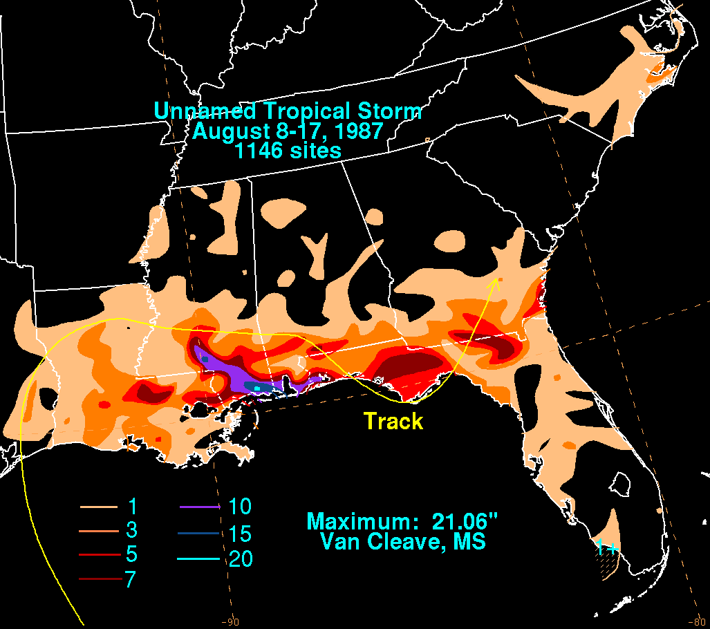
Throughout the United States, damage from the tropical storm amounted to $7.4 million, the majority of which resulted from flooding. Offshore, a woman was reported missing after she was thrown off her boat amidst rough seas produced by the storm. The system produced rainfall across a large swath of the southern states
, with many areas recording more than 5 in (127 mm). Though it made landfall in Texas, the system's asymmetric structure led to relatively little rain falling in the state, peaking at 4.25 in (108 mm) in Umbarger
. In parts of Louisiana, many streets were left impassable by high waters, creating widespread traffic delays. The most significant impact took place in southern Mississippi where rainfall in excess of 12 in (304.8 mm), peaking at 21.06 in (534.9 mm) in Van Cleave, caused significant flash flood
ing, especially along the Jackson and Tchoutacabouffa River
s. The former of these experienced a record crest of 16.8 ft (5.1 m). More than 400 people were forced to evacuate due to rising water across the region as several homes were inundated with 2 to 4 ft (0.6096 to 1.2 m) of water. In Columbia
, 12.2 in (309.9 mm) of rain fell in just eight hours, triggering flash floods that washed away a portion of a small dam. Further east in Baldwin County, Alabama
and Pensacola, Florida
, many roads ere closed or left impassable due to high water. Additionally, the system spawned a brief tornado
in Mobile County
but no damage resulted from it.
1987 Atlantic hurricane season
The 1987 Atlantic hurricane season was a below-average hurricane season that was limited by an ongoing El Niño. The season officially began on June 1, 1987, and lasted until November 30, 1987, although activity began on May 25 when a tropical depression developed in the east central...
Atlantic hurricane season
Atlantic hurricane season
The Atlantic hurricane season is the period in a year when hurricanes usually form in the Atlantic Ocean. Tropical cyclones in the North Atlantic are called hurricanes, tropical storms, or tropical depressions. In addition, there have been several storms over the years that have not been fully...
. Originating from a tropical wave
Tropical wave
Tropical waves, easterly waves, or tropical easterly waves, also known as African easterly waves in the Atlantic region, are a type of atmospheric trough, an elongated area of relatively low air pressure, oriented north to south, which move from east to west across the tropics causing areas of...
, the system was first classified as a tropical depression over the Gulf of Mexico
Gulf of Mexico
The Gulf of Mexico is a partially landlocked ocean basin largely surrounded by the North American continent and the island of Cuba. It is bounded on the northeast, north and northwest by the Gulf Coast of the United States, on the southwest and south by Mexico, and on the southeast by Cuba. In...
, southeast of Texas
Texas
Texas is the second largest U.S. state by both area and population, and the largest state by area in the contiguous United States.The name, based on the Caddo word "Tejas" meaning "friends" or "allies", was applied by the Spanish to the Caddo themselves and to the region of their settlement in...
, on August 9. Tracking north-northwestward, the cyclone slightly intensified into a tropical storm before making landfall
Landfall (meteorology)
Landfall is the event of a tropical cyclone or a waterspout coming onto land after being over water. When a waterspout makes landfall it is reclassified as a tornado, which can then cause damage inland...
in eastern Texas the following day. Once overland, the system weakened and turned towards the east and later southeast. Briefly reemerging over the Gulf on August 15, the depression moved onshore a second time in Florida
Florida
Florida is a state in the southeastern United States, located on the nation's Atlantic and Gulf coasts. It is bordered to the west by the Gulf of Mexico, to the north by Alabama and Georgia and to the east by the Atlantic Ocean. With a population of 18,801,310 as measured by the 2010 census, it...
before dissipating over eastern Georgia
Georgia (U.S. state)
Georgia is a state located in the southeastern United States. It was established in 1732, the last of the original Thirteen Colonies. The state is named after King George II of Great Britain. Georgia was the fourth state to ratify the United States Constitution, on January 2, 1788...
on August 17.
Due to the relatively weak nature of the system, it caused relatively little damage. However, heavy rains over portions of Louisiana, Mississippi, Alabama and Florida resulted in flash flood
Flash flood
A flash flood is a rapid flooding of geomorphic low-lying areas—washes, rivers, dry lakes and basins. It may be caused by heavy rain associated with a storm, hurricane, or tropical storm or meltwater from ice or snow flowing over ice sheets or snowfields...
ing, forcing the evacuation of several hundred people. In all, losses from the unnamed storm reached $7.4 million and one person was reported missing.
Meteorological history
On July 29, 1987, a tropical waveTropical wave
Tropical waves, easterly waves, or tropical easterly waves, also known as African easterly waves in the Atlantic region, are a type of atmospheric trough, an elongated area of relatively low air pressure, oriented north to south, which move from east to west across the tropics causing areas of...
emerged off the west coast of Africa
Africa
Africa is the world's second largest and second most populous continent, after Asia. At about 30.2 million km² including adjacent islands, it covers 6% of the Earth's total surface area and 20.4% of the total land area...
into the Atlantic Ocean
Atlantic Ocean
The Atlantic Ocean is the second-largest of the world's oceanic divisions. With a total area of about , it covers approximately 20% of the Earth's surface and about 26% of its water surface area...
. Tracking westward along the southern edge of the Saharan Air Layer
Saharan Air Layer
The Saharan Air Layer is an intensely dry, warm and sometimes dust-laden layer of the atmosphere which often overlies the cooler, more-humid surface air of the Atlantic Ocean. In the Sahara Desert region of North Africa, where it originates, it is the prevalent atmosphere, extending from the...
, a feature associated with large masses of dry air, little convective
Atmospheric convection
Atmospheric convection is the result of a parcel-environment instability, or temperature difference, layer in the atmosphere. Different lapse rates within dry and moist air lead to instability. Mixing of air during the day which expands the height of the planetary boundary layer leads to...
development took place over the following several days. Once near the Lesser Antilles
Lesser Antilles
The Lesser Antilles are a long, partly volcanic island arc in the Western Hemisphere. Most of its islands form the eastern boundary of the Caribbean Sea with the Atlantic Ocean, with the remainder located in the southern Caribbean just north of South America...
in early August, atmospheric conditions became more favorable for development
Tropical cyclogenesis
Tropical cyclogenesis is the term that describes the development and strengthening of a tropical cyclone in the atmosphere. The mechanisms through which tropical cyclogenesis occurs are distinctly different from those through which mid-latitude cyclogenesis occurs...
. Traveling across the Caribbean Sea
Caribbean Sea
The Caribbean Sea is a sea of the Atlantic Ocean located in the tropics of the Western hemisphere. It is bounded by Mexico and Central America to the west and southwest, to the north by the Greater Antilles, and to the east by the Lesser Antilles....
, the system became increasingly organized and a mid-level circulation
Low pressure area
A low-pressure area, or "low", is a region where the atmospheric pressure at sea level is below that of surrounding locations. Low-pressure systems form under areas of wind divergence which occur in upper levels of the troposphere. The formation process of a low-pressure area is known as...
formed shortly before the wave moved inland over Central America
Central America
Central America is the central geographic region of the Americas. It is the southernmost, isthmian portion of the North American continent, which connects with South America on the southeast. When considered part of the unified continental model, it is considered a subcontinent...
on August 7. The following day, the northern portion of the wave interacted with a cold-core low
Cold-core low
A cold-core low, also known as a cold low or cold-core cyclone, is a cyclone aloft which has an associated cold pool of air residing at high altitude within the Earth's troposphere. It is a low pressure system which strengthens with height in accordance with the thermal wind relationship. These...
over the Gulf of Mexico
Gulf of Mexico
The Gulf of Mexico is a partially landlocked ocean basin largely surrounded by the North American continent and the island of Cuba. It is bounded on the northeast, north and northwest by the Gulf Coast of the United States, on the southwest and south by Mexico, and on the southeast by Cuba. In...
, resulting in the formation of a low-level circulation, exhibiting tropical characteristics
Tropical cyclone
A tropical cyclone is a storm system characterized by a large low-pressure center and numerous thunderstorms that produce strong winds and heavy rain. Tropical cyclones strengthen when water evaporated from the ocean is released as the saturated air rises, resulting in condensation of water vapor...
, on August 9. Over the following two days, the system tracked in a general north-northwest direction towards the Texas
Texas
Texas is the second largest U.S. state by both area and population, and the largest state by area in the contiguous United States.The name, based on the Caddo word "Tejas" meaning "friends" or "allies", was applied by the Spanish to the Caddo themselves and to the region of their settlement in...
coastline. Aided by an anticyclone
Anticyclone
An anticyclone is a weather phenomenon defined by the United States' National Weather Service's glossary as "[a] large-scale circulation of winds around a central region of high atmospheric pressure, clockwise in the Northern Hemisphere, counterclockwise in the Southern Hemisphere"...
aloft, outflow
Outflow (meteorology)
Outflow, in meteorology, is air that flows outwards from a storm system. It is associated with ridging, or anticyclonic flow. In the low levels of the troposphere, outflow radiates from thunderstorms in the form of a wedge of rain-cooled air, which is visible as a thin rope-like cloud on weather...
became pronounced and convection increased in coverage and intensity. Around 1200 UTC
Coordinated Universal Time
Coordinated Universal Time is the primary time standard by which the world regulates clocks and time. It is one of several closely related successors to Greenwich Mean Time. Computer servers, online services and other entities that rely on having a universally accepted time use UTC for that purpose...
(7:00 a.m. CDT), the National Hurricane Center
National Hurricane Center
The National Hurricane Center , located at Florida International University in Miami, Florida, is the division of the National Weather Service responsible for tracking and predicting weather systems within the tropics between the Prime Meridian and the 140th meridian west poleward to the 30th...
(NHC) estimated that the system developed into a tropical depression roughly 145 miles (235 km) south-southeast of Galveston, Texas
Galveston, Texas
Galveston is a coastal city located on Galveston Island in the U.S. state of Texas. , the city had a total population of 47,743 within an area of...
.
Hours after being classified a tropical depression, the convective structure of the system deteriorated, a sign of a weakening storm; however, nearby oil rig
Oil rig
Oil rig may refer to* Drilling rig, an apparatus for on-land oil drilling* Oil platform, an apparatus for offshore oil drillingOIL RIG or OILRIG may refer to :...
s indicated a gradual increase in winds. Later on August 9, several rigs reported tropical storm-force winds – winds greater than 39 mph (63 km/h) – and the NHC estimated that the depression strengthened into a tropical storm. Operationally, however, these winds were considered to be related to local convective activity rather than the storm itself and it was not considered to be a tropical storm until post-storm analysis. As such, it was not named
Tropical cyclone naming
Tropical cyclones have officially been named since 1945 and are named for a variety of reasons, which include to facilitate communications between forecasters and the public when forecasts, watches, and warnings are issued. Names also reduce confusion about what storm is being described, as more...
and is officially classified as "Unnamed Tropical Storm." Additionally, the strongest winds were located well away from the center of circulation, a signature of subtropical cyclone
Subtropical cyclone
A subtropical cyclone is a weather system that has some characteristics of a tropical and an extratropical cyclone. As early as the 1950s, meteorologists were unclear whether they should be characterized as tropical or extratropical cyclones. They were officially recognized by the National...
s.
Remaining relatively weak, the unnamed system attained peak winds of 45 mph (75 km/h) before making landfall
Landfall (meteorology)
Landfall is the event of a tropical cyclone or a waterspout coming onto land after being over water. When a waterspout makes landfall it is reclassified as a tornado, which can then cause damage inland...
along the Texas coastline between Galveston and Beaumont
Beaumont, Texas
Beaumont is a city in and county seat of Jefferson County, Texas, United States, within the Beaumont–Port Arthur Metropolitan Statistical Area. The city's population was 118,296 at the 2010 census. With Port Arthur and Orange, it forms the Golden Triangle, a major industrial area on the...
. Once over land, the storm weakened to a tropical depression as it neared the Texas-Louisiana
Louisiana
Louisiana is a state located in the southern region of the United States of America. Its capital is Baton Rouge and largest city is New Orleans. Louisiana is the only state in the U.S. with political subdivisions termed parishes, which are local governments equivalent to counties...
border and began a gradual turn towards the east-southeast. On August 12, while over central Mississippi
Mississippi
Mississippi is a U.S. state located in the Southern United States. Jackson is the state capital and largest city. The name of the state derives from the Mississippi River, which flows along its western boundary, whose name comes from the Ojibwe word misi-ziibi...
, the cyclone attained its lowest barometric pressure of 1007 mbar
Bar (unit)
The bar is a unit of pressure equal to 100 kilopascals, and roughly equal to the atmospheric pressure on Earth at sea level. Other units derived from the bar are the megabar , kilobar , decibar , centibar , and millibar...
(hPa
Pascal (unit)
The pascal is the SI derived unit of pressure, internal pressure, stress, Young's modulus and tensile strength, named after the French mathematician, physicist, inventor, writer, and philosopher Blaise Pascal. It is a measure of force per unit area, defined as one newton per square metre...
; 29.74 inHg). On August 15, the low emerged back over the Gulf of Mexico after crossing the Florida Panhandle
Florida Panhandle
The Florida Panhandle, an informal, unofficial term for the northwestern part of Florida, is a strip of land roughly 200 miles long and 50 to 100 miles wide , lying between Alabama on the north and the west, Georgia also on the north, and the Gulf of Mexico to the south. Its eastern boundary is...
. No redevelopment took place during its brief time back over water before making its final landfall near St. Marks, Florida
St. Marks, Florida
St. Marks is a city in Wakulla County, Florida, United States. It is part of the Tallahassee, Florida, Metropolitan Statistical Area. The population was 272 at the 2000 census. As of 2004, the population estimated by the U.S. Census Bureau is 299 .-Geography:...
the following day. The depression gradually diminished before losing its identity over eastern Georgia
Georgia (U.S. state)
Georgia is a state located in the southeastern United States. It was established in 1732, the last of the original Thirteen Colonies. The state is named after King George II of Great Britain. Georgia was the fourth state to ratify the United States Constitution, on January 2, 1788...
on August 17.
Preparations and impact
Tropical cyclone warnings and watches
Warnings and watches are two levels of alert issued by national weather forecasting bodies to coastal areas threatened by the imminent approach of a tropical cyclone of tropical storm or hurricane intensity. They are notices to the local population and civil authorities to make appropriate...
was issued along the northern Gulf Coast
Gulf Coast of the United States
The Gulf Coast of the United States, sometimes referred to as the Gulf South, South Coast, or 3rd Coast, comprises the coasts of American states that are on the Gulf of Mexico, which includes Texas, Louisiana, Mississippi, Alabama, and Florida and are known as the Gulf States...
between Matagorda, Texas
Matagorda, Texas
Matagorda is an unincorporated community in Matagorda County, Texas, United States. It had a population of approximately 710 in 2000. Matagorda is at the end of State Highway 60 and beginning of Farm to Market Road 2031, which runs over the Intracoastal Waterway and south to the Gulf of Mexico...
and Morgan City, Louisiana
Morgan City, Louisiana
Morgan City is a city in St. Martin and St. Mary parishes in the U.S. state of Louisiana. The population was 12,404 at the 2010 census....
on August 9. Prior to 1987, gale warnings were issued in areas where winds above 39 mph (63 km/h) were anticipated. This warning was later discontinued on August 10 once the system moved inland and weakened. The United States Coast Guard
United States Coast Guard
The United States Coast Guard is a branch of the United States Armed Forces and one of the seven U.S. uniformed services. The Coast Guard is a maritime, military, multi-mission service unique among the military branches for having a maritime law enforcement mission and a federal regulatory agency...
advised ships to seek harbor to avoid large swells
Swell (ocean)
A swell, in the context of an ocean, sea or lake, is a series surface gravity waves that is not generated by the local wind. Swell waves often have a long wavelength but this varies with the size of the water body, e.g. rarely more than 150 m in the Mediterranean, and from event to event, with...
associated with the cyclone. Additionally, some non-essential workers were evacuated from offshore rigs. By August 13, several flash flood watch
Flash flood watch
A Flash flood watch is issued by the National Weather Service when conditions are favorable for flash flooding in flood-prone areas where grounds are already saturated from recent rains....
es were in place over portions of Mississippi, Alabama and Florida as remnants of the unnamed system slowly moved through the region.
Throughout the United States, damage from the tropical storm amounted to $7.4 million, the majority of which resulted from flooding. Offshore, a woman was reported missing after she was thrown off her boat amidst rough seas produced by the storm. The system produced rainfall across a large swath of the southern states
Southern United States
The Southern United States—commonly referred to as the American South, Dixie, or simply the South—constitutes a large distinctive area in the southeastern and south-central United States...
, with many areas recording more than 5 in (127 mm). Though it made landfall in Texas, the system's asymmetric structure led to relatively little rain falling in the state, peaking at 4.25 in (108 mm) in Umbarger
Umbarger, Texas
Umbarger is an unincorporated community in Randall County, Texas, United States. According to the Handbook of Texas, the community had an estimated population of 327 in 2000. The community is part of the Amarillo, Texas Metropolitan Statistical Area....
. In parts of Louisiana, many streets were left impassable by high waters, creating widespread traffic delays. The most significant impact took place in southern Mississippi where rainfall in excess of 12 in (304.8 mm), peaking at 21.06 in (534.9 mm) in Van Cleave, caused significant flash flood
Flash flood
A flash flood is a rapid flooding of geomorphic low-lying areas—washes, rivers, dry lakes and basins. It may be caused by heavy rain associated with a storm, hurricane, or tropical storm or meltwater from ice or snow flowing over ice sheets or snowfields...
ing, especially along the Jackson and Tchoutacabouffa River
Tchoutacabouffa River
The Tchoutacabouffa River is a stream located in Harrison County, Mississippi, at a Latitude of 30.435 and Longitude of -88.99222. The river's mouth is located just north of the city of Biloxi at Biloxi Bay and south of Interstate 10, and it flows approximately 31 miles to the north.Southern...
s. The former of these experienced a record crest of 16.8 ft (5.1 m). More than 400 people were forced to evacuate due to rising water across the region as several homes were inundated with 2 to 4 ft (0.6096 to 1.2 m) of water. In Columbia
Columbia, Mississippi
Columbia is a city in Marion County, Mississippi, United States, which was formed six years before Mississippi was admitted to statehood. Columbia was named for Columbia, South Carolina, from which many of the early settlers had migrated. The population was 6,603 as of the 2000 census. It is the...
, 12.2 in (309.9 mm) of rain fell in just eight hours, triggering flash floods that washed away a portion of a small dam. Further east in Baldwin County, Alabama
Baldwin County, Alabama
-2010:Whereas according to the 2010 U.S. Census Bureau:*85.7% White*9.4% Black*0.7% Native American*0.7% Asian*0.0% Native Hawaiian or Pacific Islander*1.5% Two or more races*4.4% Hispanic or Latino -2000:...
and Pensacola, Florida
Pensacola, Florida
Pensacola is the westernmost city in the Florida Panhandle and the county seat of Escambia County, Florida, United States of America. As of the 2000 census, the city had a total population of 56,255 and as of 2009, the estimated population was 53,752...
, many roads ere closed or left impassable due to high water. Additionally, the system spawned a brief tornado
Tornado
A tornado is a violent, dangerous, rotating column of air that is in contact with both the surface of the earth and a cumulonimbus cloud or, in rare cases, the base of a cumulus cloud. They are often referred to as a twister or a cyclone, although the word cyclone is used in meteorology in a wider...
in Mobile County
Mobile County, Alabama
Mobile County[p] is a county of the U.S. state of Alabama. Its name is in honor of a tribe of Indians, the Maubila tribe . As of 2011, its population was 415,704. Its county seat is Mobile, Alabama...
but no damage resulted from it.
See also
- Tropical cycloneTropical cycloneA tropical cyclone is a storm system characterized by a large low-pressure center and numerous thunderstorms that produce strong winds and heavy rain. Tropical cyclones strengthen when water evaporated from the ocean is released as the saturated air rises, resulting in condensation of water vapor...
- List of tropical cyclones
- List of Atlantic hurricanes
- List of North Carolina hurricanes (1980–present)