

Hurricane Georges
Encyclopedia
Hurricane Georges was a very destructive, powerful and long-lived Cape Verde-type
Category 4 hurricane. Georges was the seventh tropical storm, fourth hurricane, and second major hurricane of the 1998 Atlantic hurricane season
. The tropical cyclone
made seven landfalls on its long track through the Caribbean and Gulf of Mexico during September, becoming one of the most notable hurricane, the second most destructive storm of the season
after Hurricane Mitch
and the costliest storm in the Atlantic basin since Hurricane Andrew
. Georges killed 604 people, mainly on the island of Hispaniola
, and caused extensive damage resulting at nearly $6 billion (1998 US dollars, $ USD) in damages
mostly in St. Kitts and Nevis, Puerto Rico
and Hispaniola.
The hurricane made landfall in at least seven different countries (Antigua and Barbuda
, St. Kitts and Nevis, Haiti
, the Dominican Republic
, Cuba
and the United States) and Puerto Rico
, a Commonwealth of the United States — more than any other hurricane since Hurricane Inez
of the 1966 season
.
exited the coast of Africa on September 13. Moving westward, the large system quickly developed a closed circulation, and was classified Tropical Depression Seven on September 15. A strong upper-level ridge forced the depression to the west-northwest, where warm water temperatures allowed it to strengthen to a tropical storm on September 16. Georges's circulation developed strong banding features around a well-organized Central Dense Overcast, and with the aid of a developing anti-cyclone, Georges attained hurricane status late on September 17.
Conditions became nearly ideal for continued development, including warm water temperatures, low-level inflow to the hurricane's north, and good upper-level outflow. A banding eye developed, and Georges reached major hurricane strength on September 19 while 675 mi
(1085 km
) east-southeast of Guadeloupe
. By September 19, an upper-level anticyclone was well established over Georges and satellite pictures suggested that the hurricane was beginning to strengthen rapidly, as indicated by the cooling cloud tops, increased symmetry of the deep convection, and the warming and contracting of the well-defined 40 mi (63 km) wide eye as rapid intensification continued, and Georges peaked at a very dangerous Category 4 storm with 155 mph (250 km/h) wind and a 937 minimal pressure late on September 19 and early September 20. At that time, Georges was the most intense, strongest storm since Hurricane Hugo
and alongside Hurricane Luis
, it is one of the largest major hurricanes in the Atlantic with hurricane force windfields extending more than 150 mi (250 km) from the center and with a more than 300 mi (490 km) wide tropical storm force windfield. Shortly after peaking, upper-level wind shear from the development of an upper-level low weakened the hurricane on September 20 in the afternoon, as the central pressure had risen 26 mb as Georges approached the Leeward Islands
.
 On September 21, after weakening considerabely, Category 3 Georges made landfall directly on Antigua
and three hours later in St. Kitts, though its 175 mi (280 km) wide tropical storm force windfield affected all the Leeward Islands. After weakening to a Category 2 hurricane
over the Caribbean, upper-level shear decreased, and Georges strengthened a bit before making landfall near Fajardo, Puerto Rico
as a 115 mph (175 km/h) Category 3 hurricane later that day. Over the mountainous terrain of the island, the hurricane weakened again, but over the Mona Passage
it again re-intensified to hit eastern Dominican Republic
with winds of 120 mph (195 km/h) on September 22. Like in Puerto Rico
, Georges was greatly weakened by the mountainous terrain, and after crossing the Windward Passage
, it struck 30 mi (48 km) east of Guantánamo Bay, Cuba
on September 23. Well-defined upper-level outflow allowed the hurricane to remain well organized, and while paralleling the northern coastline of the island Georges retained minimal hurricane status.
Hurricane Georges reached the Straits of Florida
on September 24, and as it had done earlier in its lifetime, quickly restrengthened to Category 2 status on the September 25 due to warm water temperatures and little upper-level shear. It continued to the west-northwest, and struck Key West
later on September 25 with winds of 105 mph (165 km/h). Despite moving over warmer water, Georges only managed to peak at 110 mph (175 km/h) in the Gulf of Mexico, likely due to its disrupted inner core. A mid-tropospheric anticyclone pushed the hurricane slowly north-northwestward, forcing Georges to make its seventh and final landfall near Biloxi, Mississippi
on September 28. Within 24 hours, Georges had weakened to a tropical depression, and due to weak steering currents the storm looped over southern Mississippi
, then drifted to the east. The weak circulation moved eastward over the interior of the Florida Panhandle
, and dissipated on October 1 near the Florida
/Georgia
border.
and Puerto Rico
prepared for the major hurricane by boarding windows and purchasing supplies. Puerto Rican governor Pedro Rosselló
activated the island's National Guard, opened 416 shelters, and enacted a temporary prohibition on alcohol sales. More than 28,000 people across the island evacuated their homes to the shelters in the northern portion of the island. Both the Federal Emergency Management Agency
(FEMA) and the American Red Cross
deployed workers there with supplies for a potentially deadly event. The National Hurricane Center issued hurricane warnings for the island 37 hours prior to Hurricane Georges's landfall.
was caught off guard. Instead, like in Puerto Rico, Georges traversed the entire country, and passed close to Santo Domingo
. Neighboring Haiti
expected the worst, opening shelters and evacuating vulnerable people from low-lying coastal areas.
. In the potentially impacted area, Cuba's revolutionary army was sent to farm lands to harvest crops that could be destroyed during the storm. Members of the Cuban government travelled door-to-door to alert everyone of the hurricane. In addition to this, President Fidel Castro
spoke live on national television to explain the country's plans to withstand the hurricane, as well as ensuring a quick recovery effort by using all of the nation's resources. The Cuban Government issued Hurricane Warnings 30½ hours prior to landfall.
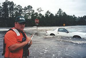
landfall forced over 1.2 million to evacuate, including much of the Florida Keys
. Despite the mandatory evacuation order, 20,000 people, including over 7,000 Key West
citizens, refused to leave. Some of those who remained to ride out the storm were shrimpers, whose boats were their entire livelihood. Insurance companies refused to insure some of the older shrimp boats, leading shrimpers to ride it out with all they had left. Due to lack of law enforcement, those who stayed in Key West went through red lights, double-parked, and disobeyed traffic laws. Long-time Florida Keys citizens noted the solitude of the time and enjoyed the island for how it once was, rather than the large crowds of tourists.
In the northern Gulf of Mexico
, Georges was forecast to attain major hurricane status and make landfall in southeastern Louisiana
. Because of this, portions of the state were evacuated, including New Orleans. There, the Louisiana Superdome
was, for the first time in its history, used as a refuge of last resort for those unable to evacuate New Orleans. More than 14,000 citizens rode out the storm in the facility, causing difficulties to supply necessities. The building had no problems related to the weather, though evacuees looted the building, stole furniture, and damaged property. However, the damage was much less than in the aftermath of Hurricane Katrina
in 2005. Many citizens in southern Mississippi
were told to leave due to a mandatory or recommended evacuation. Of those in the evacuation area, 60% actually left. Most of those who stayed remained because they believed their house was safe enough for the storm. Of those who left, most went to a relative's house in their own county. Prior to making landfall, Georges's track was very uncertain. This forced for the mandatory evacuations of Alabama
's two coastal counties, Baldwin
and Mobile
Counties, with a combined population of over 500,000 people. Despite the order, only 67% of the area actually left to a safer place. Most of those who remained stayed because they believed their house would be able to withstand the hurricane. The majority of those who did leave went to a relative's house in a safer portion of the state. In the days before making landfall, only 22% of the population in recommended evacuation areas along the Florida Panhandle
actually left. However, most of them were prepared to leave if the situation became worse. Those who did leave were concerned about the severity of the storm, while those who stayed felt their home was safe enough for the hurricane's effects. Floridians who evacuated typically left for a friend or relative's house, and only went to another area of their county.
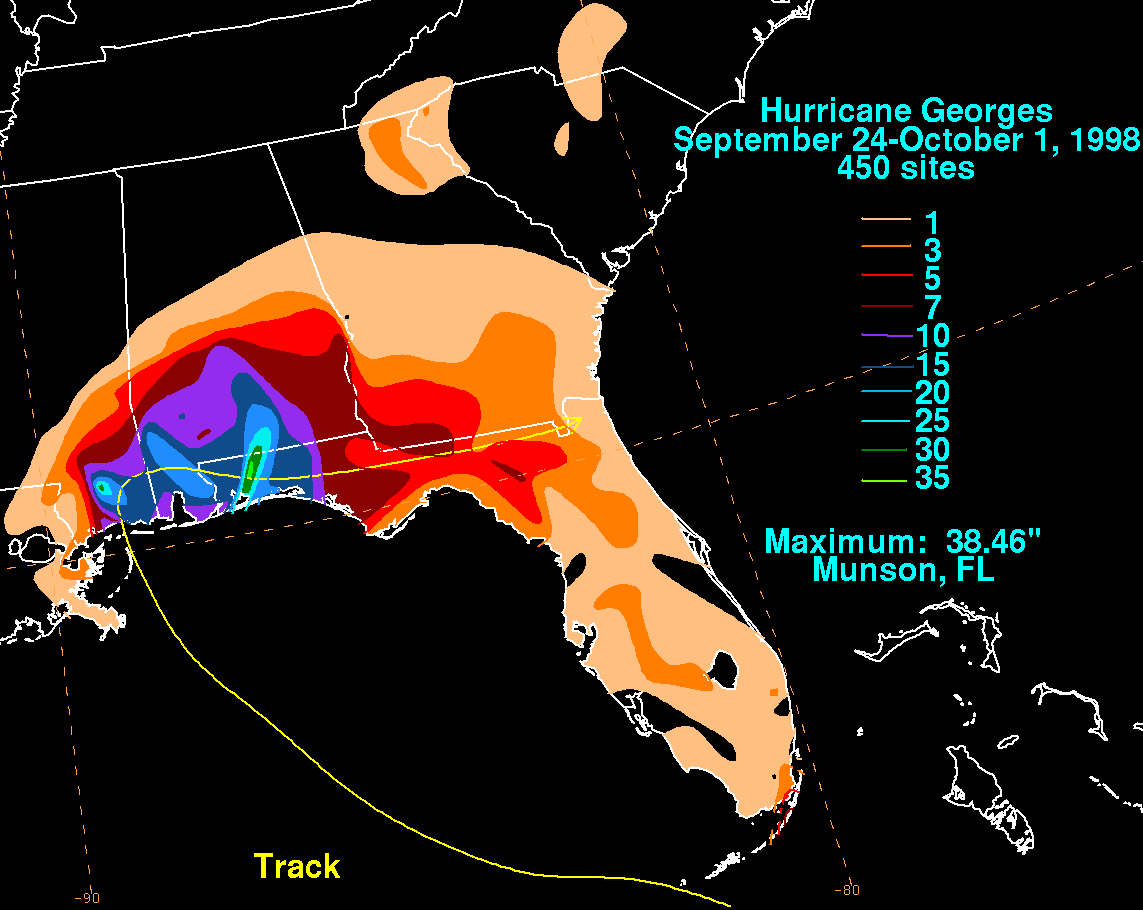
A large and long-lasting hurricane, Hurricane Georges brought torrential rainfall and mudslides along much of its path through the Greater Antilles
. In all, the hurricane caused $5.9 billion (1998 USD, $8 billion 2010 USD) in damage to the United States and its possessions, and resulted in 604 fatalities. In the two months after Georges's final landfall, the American Red Cross spent $104 million (1998 USD, $150 million 2009 USD) on relief aid through Puerto Rico
, the U.S. Virgin Islands, Florida
, Louisiana
, Alabama
, and Mississippi
, making Georges the costliest disaster aid in the program's 125-year history.
, Georges brought strong winds and heavy rainfall, amounting to a maximum of 7.5 inches (190 mm) at St. John
.
, strong winds caused severe property damage, mostly caused to roofs. 10-20% of houses were greatly impacted, including three schools. High winds during the passage of the hurricane downed telephone and power lines, causing loss of communication and power across much of the island. Between Barbuda
and Antigua, Georges killed 3 people, left 3,800 homeless and resulting at $160 million damage.
.
In Basse-Terre
, minor to moderate damage was common; the worst damage was to the banana crops, 85% to 100% devastated, with a cost of 100 millions of francs (22 millions USD). The maximal rainfall was 5 to 6 inches in this area.
The Met office in Desirade, east of Guadeloupe
had a 75 mi/h wind and a 88 mi/h sustained gust.
In Raizet, they experienced a 42 mi/h wind and a maximal gust 66 mi/h. The minimal pressure fell to 1000 mb (29.54 IHg) for several hours.
Météo France forecast 12–24 hours before a 65 mph winds with gust near 100 mph and a minimal pressure around 980 mb, meaning the worst has been avoid.
In the other part of the country, Nevis
fared better. Like on St. Kitts, high winds downed power and telephone lines, damaging the water system there. 35% of homes on the island were damaged, though none were destroyed. Rainfall and debris killed several hundred livestock and seriously damaged coconut trees, amounting to $2.5 million (1998 USD) in agricultural damage. There were no casualties reported on the island, and damaged amounted to $39 million (1998 USD).
Damage in St. Kitts totaled EC$1.2 billion (US$458 million). Total damage on Nevis amounted to $39 million. The total damage from the storm was nearly twice the very poor country's Gross Domestic Product
of US$271 million.
. Some of the islands' homes had roofs blown off. The environment suffered major damage. There were many reports of eroded soil in areas where construction was in progress. Some of the soils were planted on roads in mangrove farms
and in the sea, which could have potentially killed sea life. National Parks around the islands suffered minor damage except for Queen Elizabeth Park, which had many fallen trees. None of the schools in the area suffered any damage and opened again four days after Georges had passed. There were no fatalities in the islands and one minor injury was reported. There was no major damage to the islands' medical buildings. Pipe damage was found in two areas, but there was no damage to the sewage systems.
The total damage in the British Virgin Islands was valued at US$9.404 million.
In other nearby islands, Georges impact was relatively minor to moderate. Power outages, flooding, and minor to moderate structural damage was common.
tornadoes on the island, though they caused little damage. Georges dropped immense precipitation in the mountain regions, amounting to a maximum of 30.51 inches (775 mm) in Jayuya
with many other locations reporting over 1 foot (300 mm). The mountain flooding drained off in the island's rivers, causing every river to overflow its banks. Near the coast, the surfeit of water carved new channels from the record discharge rate. The storm's strong winds caused beach erosion
in many places along the coastline. Eroded beaches, flooding, and debris left many roads impassable or destroyed, isolating some villages on the western portion of the island. Over 22,000 people were sheltered in 139 shelters in cities throughout the island. All experienced power outages, and after the storm passed through, lack of water and sewer systems was a serious problem.
 Hurricane Georges was the first hurricane to cross the entire island since the San Ciprian Hurricane in 1932. Its large circulation brought fierce winds to the entire island, damaging 72,605 houses and destroying 28,005 homes. This left tens of thousands homeless after the storm's passage. High winds downed nearly half of the island's electric and telephone lines, leaving 96% of the population powerless and 8.4% of telephone customers without service. Lack of electricity greatly damaged the water system, resulting in the loss of water and sewer service for 75% of the island. Georges's deluge of rainfall caused significant damage to the agricultural industry, including the loss of 75% of its coffee crop, 95% of its banana or plantain crop, and 65% of its live poultry.
Luis Muñoz Marín International Airport
recorded a 69 knots sustained wind and a 81 knots sustained gust and a 979.7 mb lowest pressure. The lowest recorded was in Roosevelt Roads Naval Station
with 971.4 mb while the highest sustained wind and gust reported at an official site was 78 knots and 93 knots, respectively, at 2302 UTC 21 September. One of the most important observations reported was in Fajardo, Puerto Rico where the Civil Defense office measured a sustained wind of 96 knots with gusts to 113 knots at 2130 UTC 21 September and a 983.1 mb.
 In all, Hurricane Georges caused $1.9 billion in damage (1998 USD, $2.75 billion 2009 USD), but due to well-executed warnings there were no reported casualties.
In the nearby small island of Culebra
, Georges destroyed 74 houses and damaged 89 others, although damage estimates are not available there.
, Georges brought strong winds and very heavy rains, along with a 7 foot (2 m) storm surge. Nearly 10 hours of continuous rainfall resulted in mudslides and overflown rivers across the mountainous country, damaging many cities along the southern coastline, including the capital. 120 mph (54 m/s) winds downed and uprooted trees across much of the country, littering streets with debris and mud. Thousands of houses were destroyed, while many were completely destroyed from the flooding and winds. The entire country was without electricity during the aftermath of the storm, damaging water and communication systems. Heavy wind damage and flooding caused extensive damage to the airport in Santo Domingo
, restricting usage to military and non-commercial flights.
 Most impacted by Hurricane Georges was the agricultural industry. The areas hardest hit by the hurricane coincided with the country's main crop-growing areas, including the provinces around Santo Domingo. After a severe drought in 1997, extreme rainfall damaged around 470000 acre (190,202 ha) of food crops, including various types of vegetables, fruits, and roots — some of the country's main diet food. Substantial amounts of tobacco and sugar plantations, the country's most important export crop, were severely damaged. The extreme flooding caused great losses in the poultry industry, an important economy in the area. The Dominican Republic had to import significant amounts of rice and other crops to compensate for the losses.
Death toll reports were slow in the wake of the storm, but a total of 380 people died from Hurricane Georges. Damage in the Dominican Republic amounted to $1.2 billion (1998 USD, $1.8 billion 2009 USD).
, Georges was a weakened hurricane, but it still brought heavy rainfall across the entire country. The capital city of Port-au-Prince was largely unharmed, with the exception of flooding in low-lying coastal areas, damaging the main commercial port. The rest of the country, however, experienced a significant number of mudslides due to deforestation along the mountains. These mudslides destroyed or severely damaged many houses, leaving 167,332 homeless. Damage was greatest along the northern coastline from Cap-Haïtien
to Gonaïves
due to the flooding and mudslides. On the southern coast, the head of a U.S.-based medical team, stranded for several days by flooding in the remote town of Belle Anse, anticipated a rise in malnutrition, disease, homelessness and poverty. Lack of electricity led to a total disruption of Haiti's water supply system, causing a decrease in sanitary conditions across the poorest country in the Western Hemisphere
. In all, 209 people died in Haiti
.
Like in the Dominican Republic, the agricultural sector suffered extreme damage. After a severe drought in 1997, Georges's severe flooding stopped any chances of recovering quickly. Most of the country's significant crop land, including Artibonite Valley
, suffered total losses. Up to 80% of banana plantations were lost, while vegetable, roots, tubers, and other food crops were ruined. In addition, thousands of small farm animals were either killed or lost. Total agricultural losses amounted to $179 million (1998 USD, $250 million 2009 USD). The country requested food assistance in the aftermath of the hurricane to alleviate the serious losses.
. Several other locations reported over a foot (300 mm) of precipitation as well. Storm surge of 4 – 6 feet (1 – 2 m) was expected along the eastern coastline, along with dangerous waves on top of the surge. Though winds were reduced by the time Georges hit Cuba, it still retained winds of 75 mph (34 m/s), along with stronger gusts in squalls.
The hurricane's heavy rainfall resulted in mudslides along the mountainous terrain. This, combined with strong winds, damaged 60,475 homes, of which 3,481 were completely destroyed. In the country, 100,000 were left homeless due to Hurricane Georges. High winds downed power lines, trees, and telephone poles, leaving many in eastern Cuba without electricity in the aftermath of the storm. Along the coast, severe flooding washed out railroad and highway bridges. Though eastern Cuba was the area most affected, the central and western portion of the island, including Havana, experienced torrential rains and strong wind gusts. There, strong waves broke over the seawall
, and caused heavy flood damage to some of the town's old buildings.
Like in Puerto Rico and Hispaniola, the severe drought during the El Niño of 1997 exacerbated the flood's disruption to crops in eastern Cuba. The heavy rainfall from Georges damaged the crops greatly, despite the effort to harvest them prior to its arrival. Up to 70% of the plantain crop, a chief food in the country's diet, was destroyed. The sugarcane crop fared badly as well, limiting one of the country's important export crops. The coffee and cocoa plantations also suffered from the hurricane, further damaging the country's food supply.
Well-executed evacuations and warnings limited the death toll to six, while damage amounted to $40 million (1998 USD, $52.9 million 2009 USD).
, it passed to the south of the archipelago. It brought 70 mph (110 km/h) winds to Turks and Caicos Islands
and South Andros
, as well as precipitation in the storm's outer bands. Though damage was minimal, one person died in the country.

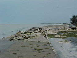 The eye of the storm passed near Key West about midday. Upon making landfall, Hurricane Georges brought a storm surge of up to 12 feet (3.6 m) in Tavernier, Florida
, with similar but lesser amounts along the Florida Keys. The islands, some only 7 feet (2 m) high and 300 yards (275 m) wide, are easily flooded, and with up to 10 foot (3 m) waves many parts of the Overseas Highway
were under water. Strong winds downed palm trees and power lines, leaving all of the Keys without power. Georges's waves overturned 2 boats in Key West, damaged 1,536 houses, and destroyed 173 homes, many of which were mobile homes. Rainfall amounts amounted to a maximum of 8.41 inches (210 mm) in Tavernier, while other locations reported lesser amounts. Damage in the Florida Keys amounted to $200 million (1998 USD, $250 million 2009 USD).
Further up the coast, the hurricane's outer bands produced light rainfall of up to 3 inches (80 mm). Strong winds knocked down power lines, leaving 200,000 without power in the Miami area. Damage was minimal, and there were no reported casualties.
, the first line of protection for the coasts of Louisiana and Mississippi
. The long island chain was reduced to a few banks of sand in the Gulf. Grand Gosier, the home to a flock of the endangered Brown Pelican
s, experienced severe flooding, destroying their habitats.
Upon making landfall, Hurricane Georges brought a storm surge peaking at 8.9 feet (2.4 m) in Pointe a la Hache, Louisiana
, along with higher waves on top of it. Located on the weaker side of the storm, rainfall totals were low, and amounted to a maximum of 3 inches (8 cm). Winds were generally light, peaking at 45 mph (20 m/s). Overall, damage was minimal in Louisiana. High winds downed power lines, leaving 160,000 without electricity across the state. In the state, Hurricane Georges caused $25 million (1998 USD, $32 million 2009 USD) in damage, but no deaths due to well-executed evacuations.
 Upon making landfall, Hurricane Georges brought a storm surge of up to 8.9 feet (2.7 m) in Biloxi, Mississippi
. While stalling over the southern portion of the state, it produced torrential rainfall, amounting to 16.7 inches (420 mm) in Pascagoula
. The heavy rainfall contributed to significant river overflowing, including the Tchoutacabouffa River
at D'Iberville
, which set a record crest of 19 feet (5.7 m). The overflown rivers in the southern portion of the state flooded homes and forced more to evacuate just days after the hurricane came through. In addition, squall lines spawned multiple tornadoes, damaging evacuation shelters in Pascagoula and Gautier.
Beach erosion occurred along the coastline, resulting in some property damage on beach houses. Around Biloxi, coastal casinos and the shipyards experienced little from the storm. Inland, high winds and flooding caused extensive damage to homes. Georges's winds downed power lines, leaving 230,000 without power after the storm. After the storm, over 6,800 people stayed in 49 different shelters. One shelter in Forrest County
was damaged, forcing the citizens to another camp. Overall, Hurricane Georges caused $665 million (1998 USD, $790 million 2009 USD) in damage, though no deaths due to well-executed evacuations.
 Upon making landfall, Georges brought a strong storm surge peaking at 11.9 feet (3.6 m) in Fort Morgan
, along with 25 foot (7.6 m) waves on top of it. While moving slowly through the state, it dropped torrential rainfall, peaking at 29.66 inches (75 cm) in Bay Minette
. Outer squalls spawned tornadoes in the southeast portion of the state, though damage from them was minimal. Along the coastline, heavy rainfall and strong waves caused extensive property damage. In Gulf Shores
, for example, 251 houses, 16 apartment buildings, and 70 businesses experienced significant damage. On the barrier island, Dauphin Island, the hurricane destroyed 50 houses and left 40 uninhabitable. Further inland, high winds downed power lines and trees, leaving 177,000 people without power after the storm. 17 shelters housed 4,977 people in the aftermath of the storm. Damage to the buildings were minimal to non-existent, with the only direct effect from the hurricane being a brief interruption of electricity.
Overall, damage in Alabama amounted to $125 million (1998 USD, $164 million 2009 USD). Freshwater flooding in Mobile resulted in one death, the only death in the United States.
recorded a wind gust of 90 mph (145 km/h). Outer squalls produced a tornado outbreak of 28 twisters, most of which occurred in northwestern Florida.
6,525 people stayed in 34 shelters in the Florida Panhandle
, though the shelters experienced little from the hurricane. Damage amounted to $100 million (1998 USD, $127 million 2009 USD), though no deaths were reported.
, the remnants of Georges dropped 4 inches (101.6 mm) of rain across Franklin County
. In Appling County
however, rainfall of 5-7 inches closed several roads and left $10,000 (1998 USD) in damage. Atkinson County
also reported flood damage of $15,000 (1998 USD) in damage. Stewart County, received over 5 inches (127 mm) of rain which caused extensive flooding that left several roads impassable. Damage from the storm totaled to $33,000 (1998 USD). In the town of Lumpkin, a funnel cloud
was reported but there were no damage. In addition to the flooding, the remnants of Georges spawned numerous tornadoes across the state of Georgia
. In Randolph County, an F1 tornado uprooted several trees and injured one person. Damage from the tornado totaled $500,000 dollars (1998 USD).
in 1960, Hurricane Hugo
in 1989, Hurricane Isabel
in 2003, Hurricane Ivan
in 2004, and recently Hurricane Earl
in 2010.
.
Cape Verde-type hurricane
A Cape Verde-type hurricane is an Atlantic hurricane that develops near the Cape Verde islands, off the west coast of Africa. The average hurricane season has about two Cape Verde-type hurricanes, which are usually the largest and most intense storms of the season because they often have plenty of...
Category 4 hurricane. Georges was the seventh tropical storm, fourth hurricane, and second major hurricane of the 1998 Atlantic hurricane season
1998 Atlantic hurricane season
The 1998 Atlantic hurricane season officially began on June 1, 1998, and lasted until November 30, 1998. These dates conventionally delimit the period of each year when most tropical cyclones form in the Atlantic basin; however, the season extended through December 1 as Hurricane Nicole remained...
. The tropical cyclone
Tropical cyclone
A tropical cyclone is a storm system characterized by a large low-pressure center and numerous thunderstorms that produce strong winds and heavy rain. Tropical cyclones strengthen when water evaporated from the ocean is released as the saturated air rises, resulting in condensation of water vapor...
made seven landfalls on its long track through the Caribbean and Gulf of Mexico during September, becoming one of the most notable hurricane, the second most destructive storm of the season
Atlantic hurricane season
The Atlantic hurricane season is the period in a year when hurricanes usually form in the Atlantic Ocean. Tropical cyclones in the North Atlantic are called hurricanes, tropical storms, or tropical depressions. In addition, there have been several storms over the years that have not been fully...
after Hurricane Mitch
Hurricane Mitch
Hurricane Mitch was the most powerful hurricane and the most destructive of the 1998 Atlantic hurricane season, with maximum sustained winds of 180 mph . The storm was the thirteenth tropical storm, ninth hurricane, and third major hurricane of the season. Along with Hurricane Georges, Mitch...
and the costliest storm in the Atlantic basin since Hurricane Andrew
Hurricane Andrew
Hurricane Andrew was the third Category 5 hurricane to make landfall in the United States, after the Labor Day Hurricane of 1935 and Hurricane Camille in 1969. Andrew was the first named storm and only major hurricane of the otherwise inactive 1992 Atlantic hurricane season...
. Georges killed 604 people, mainly on the island of Hispaniola
Hispaniola
Hispaniola is a major island in the Caribbean, containing the two sovereign states of the Dominican Republic and Haiti. The island is located between the islands of Cuba to the west and Puerto Rico to the east, within the hurricane belt...
, and caused extensive damage resulting at nearly $6 billion (1998 US dollars, $ USD) in damages
mostly in St. Kitts and Nevis, Puerto Rico
Puerto Rico
Puerto Rico , officially the Commonwealth of Puerto Rico , is an unincorporated territory of the United States, located in the northeastern Caribbean, east of the Dominican Republic and west of both the United States Virgin Islands and the British Virgin Islands.Puerto Rico comprises an...
and Hispaniola.
The hurricane made landfall in at least seven different countries (Antigua and Barbuda
Antigua and Barbuda
Antigua and Barbuda is a twin-island nation lying between the Caribbean Sea and the Atlantic Ocean. It consists of two major inhabited islands, Antigua and Barbuda, and a number of smaller islands...
, St. Kitts and Nevis, Haiti
Haiti
Haiti , officially the Republic of Haiti , is a Caribbean country. It occupies the western, smaller portion of the island of Hispaniola, in the Greater Antillean archipelago, which it shares with the Dominican Republic. Ayiti was the indigenous Taíno or Amerindian name for the island...
, the Dominican Republic
Dominican Republic
The Dominican Republic is a nation on the island of La Hispaniola, part of the Greater Antilles archipelago in the Caribbean region. The western third of the island is occupied by the nation of Haiti, making Hispaniola one of two Caribbean islands that are shared by two countries...
, Cuba
Cuba
The Republic of Cuba is an island nation in the Caribbean. The nation of Cuba consists of the main island of Cuba, the Isla de la Juventud, and several archipelagos. Havana is the largest city in Cuba and the country's capital. Santiago de Cuba is the second largest city...
and the United States) and Puerto Rico
Puerto Rico
Puerto Rico , officially the Commonwealth of Puerto Rico , is an unincorporated territory of the United States, located in the northeastern Caribbean, east of the Dominican Republic and west of both the United States Virgin Islands and the British Virgin Islands.Puerto Rico comprises an...
, a Commonwealth of the United States — more than any other hurricane since Hurricane Inez
Hurricane Inez
Hurricane Inez was a deadly, destructive, powerful and very long-lived Cape Verde-type hurricane that carved an erratic path through the Lesser Antilles, Hispaniola, Cuba, the Bahamas, Florida, and Mexico in 1966...
of the 1966 season
1966 Atlantic hurricane season
The 1966 Atlantic hurricane season officially began on June 1, 1966, and lasted until November 30, 1966. These dates conventionally delimit the period of each year when most tropical cyclones form in the Atlantic basin. The 1966 season was near normal with eleven tropical storms...
.
Meteorological history
A tropical waveTropical wave
Tropical waves, easterly waves, or tropical easterly waves, also known as African easterly waves in the Atlantic region, are a type of atmospheric trough, an elongated area of relatively low air pressure, oriented north to south, which move from east to west across the tropics causing areas of...
exited the coast of Africa on September 13. Moving westward, the large system quickly developed a closed circulation, and was classified Tropical Depression Seven on September 15. A strong upper-level ridge forced the depression to the west-northwest, where warm water temperatures allowed it to strengthen to a tropical storm on September 16. Georges's circulation developed strong banding features around a well-organized Central Dense Overcast, and with the aid of a developing anti-cyclone, Georges attained hurricane status late on September 17.
Conditions became nearly ideal for continued development, including warm water temperatures, low-level inflow to the hurricane's north, and good upper-level outflow. A banding eye developed, and Georges reached major hurricane strength on September 19 while 675 mi
Mile
A mile is a unit of length, most commonly 5,280 feet . The mile of 5,280 feet is sometimes called the statute mile or land mile to distinguish it from the nautical mile...
(1085 km
Kilometre
The kilometre is a unit of length in the metric system, equal to one thousand metres and is therefore exactly equal to the distance travelled by light in free space in of a second...
) east-southeast of Guadeloupe
Guadeloupe
Guadeloupe is an archipelago located in the Leeward Islands, in the Lesser Antilles, with a land area of 1,628 square kilometres and a population of 400,000. It is the first overseas region of France, consisting of a single overseas department. As with the other overseas departments, Guadeloupe...
. By September 19, an upper-level anticyclone was well established over Georges and satellite pictures suggested that the hurricane was beginning to strengthen rapidly, as indicated by the cooling cloud tops, increased symmetry of the deep convection, and the warming and contracting of the well-defined 40 mi (63 km) wide eye as rapid intensification continued, and Georges peaked at a very dangerous Category 4 storm with 155 mph (250 km/h) wind and a 937 minimal pressure late on September 19 and early September 20. At that time, Georges was the most intense, strongest storm since Hurricane Hugo
Hurricane Hugo
Hurricane Hugo was a classical, destructive and rare Cape Verde-type hurricane which struck the Caribbean islands of Guadeloupe, Montserrat, St. Croix, Puerto Rico and the USA mainland in South Carolina as a Category 4 hurricane during September of the 1989 Atlantic hurricane season...
and alongside Hurricane Luis
Hurricane Luis
Hurricane Luis was one of the deadliest and most destructive hurricanes of the 1995 Atlantic hurricane season, with maximum sustained winds of 140 mph . The storm was the twelfth tropical storm, sixth hurricane, and second major hurricane of the season...
, it is one of the largest major hurricanes in the Atlantic with hurricane force windfields extending more than 150 mi (250 km) from the center and with a more than 300 mi (490 km) wide tropical storm force windfield. Shortly after peaking, upper-level wind shear from the development of an upper-level low weakened the hurricane on September 20 in the afternoon, as the central pressure had risen 26 mb as Georges approached the Leeward Islands
Leeward Islands
The Leeward Islands are a group of islands in the West Indies. They are the northern islands of the Lesser Antilles chain. As a group they start east of Puerto Rico and reach southward to Dominica. They are situated where the northeastern Caribbean Sea meets the western Atlantic Ocean...
.
Antigua
Antigua , also known as Waladli, is an island in the West Indies, in the Leeward Islands in the Caribbean region, the main island of the country of Antigua and Barbuda. Antigua means "ancient" in Spanish and was named by Christopher Columbus after an icon in Seville Cathedral, Santa Maria de la...
and three hours later in St. Kitts, though its 175 mi (280 km) wide tropical storm force windfield affected all the Leeward Islands. After weakening to a Category 2 hurricane
Saffir-Simpson Hurricane Scale
The Saffir–Simpson Hurricane Scale , or the Saffir–Simpson Hurricane Wind Scale , classifies hurricanes — Western Hemisphere tropical cyclones that exceed the intensities of tropical depressions and tropical storms — into five categories distinguished by the intensities of their sustained winds...
over the Caribbean, upper-level shear decreased, and Georges strengthened a bit before making landfall near Fajardo, Puerto Rico
Fajardo, Puerto Rico
Fajardo is a small city in Puerto Rico located in the east region of the island, bordering the Atlantic Ocean, north of Ceiba and east of Luquillo.Fajardo is spread over 7 wards and Downtown Fajardo , which serves as the administrative center of the city...
as a 115 mph (175 km/h) Category 3 hurricane later that day. Over the mountainous terrain of the island, the hurricane weakened again, but over the Mona Passage
Mona Passage
The Mona Passage is a strait that separates the islands of Hispaniola and Puerto Rico. The Mona Passage connects the Atlantic Ocean to the Caribbean Sea, and is an important shipping route between the Atlantic and the Panama Canal....
it again re-intensified to hit eastern Dominican Republic
Dominican Republic
The Dominican Republic is a nation on the island of La Hispaniola, part of the Greater Antilles archipelago in the Caribbean region. The western third of the island is occupied by the nation of Haiti, making Hispaniola one of two Caribbean islands that are shared by two countries...
with winds of 120 mph (195 km/h) on September 22. Like in Puerto Rico
Puerto Rico
Puerto Rico , officially the Commonwealth of Puerto Rico , is an unincorporated territory of the United States, located in the northeastern Caribbean, east of the Dominican Republic and west of both the United States Virgin Islands and the British Virgin Islands.Puerto Rico comprises an...
, Georges was greatly weakened by the mountainous terrain, and after crossing the Windward Passage
Windward Passage
The Windward Passage is a strait in the Caribbean Sea, between the islands of Cuba and Hispaniola. The strait specifically lies between the easternmost region of Cuba and the northwest of Haiti.80km wide, the Windward Passage has a threshold depth of 1,700m...
, it struck 30 mi (48 km) east of Guantánamo Bay, Cuba
Cuba
The Republic of Cuba is an island nation in the Caribbean. The nation of Cuba consists of the main island of Cuba, the Isla de la Juventud, and several archipelagos. Havana is the largest city in Cuba and the country's capital. Santiago de Cuba is the second largest city...
on September 23. Well-defined upper-level outflow allowed the hurricane to remain well organized, and while paralleling the northern coastline of the island Georges retained minimal hurricane status.
Hurricane Georges reached the Straits of Florida
Straits of Florida
The Straits of Florida, Florida Straits, or Florida Strait is a strait located south-southeast of the North American mainland, generally accepted to be between the Gulf of Mexico and the Atlantic Ocean, and between the Florida Keys and Cuba. The strait carries the Florida Current, the beginning of...
on September 24, and as it had done earlier in its lifetime, quickly restrengthened to Category 2 status on the September 25 due to warm water temperatures and little upper-level shear. It continued to the west-northwest, and struck Key West
Key West
Key West is an island in the Straits of Florida on the North American continent at the southernmost tip of the Florida Keys. Key West is home to the southernmost point in the Continental United States; the island is about from Cuba....
later on September 25 with winds of 105 mph (165 km/h). Despite moving over warmer water, Georges only managed to peak at 110 mph (175 km/h) in the Gulf of Mexico, likely due to its disrupted inner core. A mid-tropospheric anticyclone pushed the hurricane slowly north-northwestward, forcing Georges to make its seventh and final landfall near Biloxi, Mississippi
Biloxi, Mississippi
Biloxi is a city in Harrison County, Mississippi, in the United States. The 2010 census recorded the population as 44,054. Along with Gulfport, Biloxi is a county seat of Harrison County....
on September 28. Within 24 hours, Georges had weakened to a tropical depression, and due to weak steering currents the storm looped over southern Mississippi
Mississippi
Mississippi is a U.S. state located in the Southern United States. Jackson is the state capital and largest city. The name of the state derives from the Mississippi River, which flows along its western boundary, whose name comes from the Ojibwe word misi-ziibi...
, then drifted to the east. The weak circulation moved eastward over the interior of the Florida Panhandle
Florida Panhandle
The Florida Panhandle, an informal, unofficial term for the northwestern part of Florida, is a strip of land roughly 200 miles long and 50 to 100 miles wide , lying between Alabama on the north and the west, Georgia also on the north, and the Gulf of Mexico to the south. Its eastern boundary is...
, and dissipated on October 1 near the Florida
Florida
Florida is a state in the southeastern United States, located on the nation's Atlantic and Gulf coasts. It is bordered to the west by the Gulf of Mexico, to the north by Alabama and Georgia and to the east by the Atlantic Ocean. With a population of 18,801,310 as measured by the 2010 census, it...
/Georgia
Georgia (U.S. state)
Georgia is a state located in the southeastern United States. It was established in 1732, the last of the original Thirteen Colonies. The state is named after King George II of Great Britain. Georgia was the fourth state to ratify the United States Constitution, on January 2, 1788...
border.
Lesser Antilles
Puerto Rico
In the days prior to the hurricane's arrival, thousands of citizens in the Leeward IslandsLeeward Islands
The Leeward Islands are a group of islands in the West Indies. They are the northern islands of the Lesser Antilles chain. As a group they start east of Puerto Rico and reach southward to Dominica. They are situated where the northeastern Caribbean Sea meets the western Atlantic Ocean...
and Puerto Rico
Puerto Rico
Puerto Rico , officially the Commonwealth of Puerto Rico , is an unincorporated territory of the United States, located in the northeastern Caribbean, east of the Dominican Republic and west of both the United States Virgin Islands and the British Virgin Islands.Puerto Rico comprises an...
prepared for the major hurricane by boarding windows and purchasing supplies. Puerto Rican governor Pedro Rosselló
Pedro Rosselló
Pedro Juan Rosselló González, M.D., , is a Puerto Rican physician and politician who served as the sixth Governor of the Commonwealth of Puerto Rico from 1993 to 2001...
activated the island's National Guard, opened 416 shelters, and enacted a temporary prohibition on alcohol sales. More than 28,000 people across the island evacuated their homes to the shelters in the northern portion of the island. Both the Federal Emergency Management Agency
Federal Emergency Management Agency
The Federal Emergency Management Agency is an agency of the United States Department of Homeland Security, initially created by Presidential Reorganization Plan No. 1 of 1978 and implemented by two Executive Orders...
(FEMA) and the American Red Cross
American Red Cross
The American Red Cross , also known as the American National Red Cross, is a volunteer-led, humanitarian organization that provides emergency assistance, disaster relief and education inside the United States. It is the designated U.S...
deployed workers there with supplies for a potentially deadly event. The National Hurricane Center issued hurricane warnings for the island 37 hours prior to Hurricane Georges's landfall.
Hispaniola
Due to initial forecasts of the hurricane brushing the northern portion of the country, the Dominican RepublicDominican Republic
The Dominican Republic is a nation on the island of La Hispaniola, part of the Greater Antilles archipelago in the Caribbean region. The western third of the island is occupied by the nation of Haiti, making Hispaniola one of two Caribbean islands that are shared by two countries...
was caught off guard. Instead, like in Puerto Rico, Georges traversed the entire country, and passed close to Santo Domingo
Santo Domingo
Santo Domingo, known officially as Santo Domingo de Guzmán, is the capital and largest city in the Dominican Republic. Its metropolitan population was 2,084,852 in 2003, and estimated at 3,294,385 in 2010. The city is located on the Caribbean Sea, at the mouth of the Ozama River...
. Neighboring Haiti
Haiti
Haiti , officially the Republic of Haiti , is a Caribbean country. It occupies the western, smaller portion of the island of Hispaniola, in the Greater Antillean archipelago, which it shares with the Dominican Republic. Ayiti was the indigenous Taíno or Amerindian name for the island...
expected the worst, opening shelters and evacuating vulnerable people from low-lying coastal areas.
Cuba
Prior to making landfall, more than 200,000 people were evacuated from coastal areas in eastern CubaCuba
The Republic of Cuba is an island nation in the Caribbean. The nation of Cuba consists of the main island of Cuba, the Isla de la Juventud, and several archipelagos. Havana is the largest city in Cuba and the country's capital. Santiago de Cuba is the second largest city...
. In the potentially impacted area, Cuba's revolutionary army was sent to farm lands to harvest crops that could be destroyed during the storm. Members of the Cuban government travelled door-to-door to alert everyone of the hurricane. In addition to this, President Fidel Castro
Fidel Castro
Fidel Alejandro Castro Ruz is a Cuban revolutionary and politician, having held the position of Prime Minister of Cuba from 1959 to 1976, and then President from 1976 to 2008. He also served as the First Secretary of the Communist Party of Cuba from the party's foundation in 1961 until 2011...
spoke live on national television to explain the country's plans to withstand the hurricane, as well as ensuring a quick recovery effort by using all of the nation's resources. The Cuban Government issued Hurricane Warnings 30½ hours prior to landfall.
United States
Initial forecasts of a southeastern FloridaFlorida
Florida is a state in the southeastern United States, located on the nation's Atlantic and Gulf coasts. It is bordered to the west by the Gulf of Mexico, to the north by Alabama and Georgia and to the east by the Atlantic Ocean. With a population of 18,801,310 as measured by the 2010 census, it...
landfall forced over 1.2 million to evacuate, including much of the Florida Keys
Florida Keys
The Florida Keys are a coral archipelago in southeast United States. They begin at the southeastern tip of the Florida peninsula, about south of Miami, and extend in a gentle arc south-southwest and then westward to Key West, the westernmost of the inhabited islands, and on to the uninhabited Dry...
. Despite the mandatory evacuation order, 20,000 people, including over 7,000 Key West
Key West
Key West is an island in the Straits of Florida on the North American continent at the southernmost tip of the Florida Keys. Key West is home to the southernmost point in the Continental United States; the island is about from Cuba....
citizens, refused to leave. Some of those who remained to ride out the storm were shrimpers, whose boats were their entire livelihood. Insurance companies refused to insure some of the older shrimp boats, leading shrimpers to ride it out with all they had left. Due to lack of law enforcement, those who stayed in Key West went through red lights, double-parked, and disobeyed traffic laws. Long-time Florida Keys citizens noted the solitude of the time and enjoyed the island for how it once was, rather than the large crowds of tourists.
In the northern Gulf of Mexico
Gulf of Mexico
The Gulf of Mexico is a partially landlocked ocean basin largely surrounded by the North American continent and the island of Cuba. It is bounded on the northeast, north and northwest by the Gulf Coast of the United States, on the southwest and south by Mexico, and on the southeast by Cuba. In...
, Georges was forecast to attain major hurricane status and make landfall in southeastern Louisiana
Louisiana
Louisiana is a state located in the southern region of the United States of America. Its capital is Baton Rouge and largest city is New Orleans. Louisiana is the only state in the U.S. with political subdivisions termed parishes, which are local governments equivalent to counties...
. Because of this, portions of the state were evacuated, including New Orleans. There, the Louisiana Superdome
Louisiana Superdome
The Mercedes-Benz Superdome, previously known as the Louisiana Superdome and colloquially known as the Superdome, is a sports and exhibition arena located in the Central Business District of New Orleans, Louisiana, USA...
was, for the first time in its history, used as a refuge of last resort for those unable to evacuate New Orleans. More than 14,000 citizens rode out the storm in the facility, causing difficulties to supply necessities. The building had no problems related to the weather, though evacuees looted the building, stole furniture, and damaged property. However, the damage was much less than in the aftermath of Hurricane Katrina
Hurricane Katrina
Hurricane Katrina of the 2005 Atlantic hurricane season was a powerful Atlantic hurricane. It is the costliest natural disaster, as well as one of the five deadliest hurricanes, in the history of the United States. Among recorded Atlantic hurricanes, it was the sixth strongest overall...
in 2005. Many citizens in southern Mississippi
Mississippi
Mississippi is a U.S. state located in the Southern United States. Jackson is the state capital and largest city. The name of the state derives from the Mississippi River, which flows along its western boundary, whose name comes from the Ojibwe word misi-ziibi...
were told to leave due to a mandatory or recommended evacuation. Of those in the evacuation area, 60% actually left. Most of those who stayed remained because they believed their house was safe enough for the storm. Of those who left, most went to a relative's house in their own county. Prior to making landfall, Georges's track was very uncertain. This forced for the mandatory evacuations of Alabama
Alabama
Alabama is a state located in the southeastern region of the United States. It is bordered by Tennessee to the north, Georgia to the east, Florida and the Gulf of Mexico to the south, and Mississippi to the west. Alabama ranks 30th in total land area and ranks second in the size of its inland...
's two coastal counties, Baldwin
Baldwin County, Alabama
-2010:Whereas according to the 2010 U.S. Census Bureau:*85.7% White*9.4% Black*0.7% Native American*0.7% Asian*0.0% Native Hawaiian or Pacific Islander*1.5% Two or more races*4.4% Hispanic or Latino -2000:...
and Mobile
Mobile County, Alabama
Mobile County[p] is a county of the U.S. state of Alabama. Its name is in honor of a tribe of Indians, the Maubila tribe . As of 2011, its population was 415,704. Its county seat is Mobile, Alabama...
Counties, with a combined population of over 500,000 people. Despite the order, only 67% of the area actually left to a safer place. Most of those who remained stayed because they believed their house would be able to withstand the hurricane. The majority of those who did leave went to a relative's house in a safer portion of the state. In the days before making landfall, only 22% of the population in recommended evacuation areas along the Florida Panhandle
Florida Panhandle
The Florida Panhandle, an informal, unofficial term for the northwestern part of Florida, is a strip of land roughly 200 miles long and 50 to 100 miles wide , lying between Alabama on the north and the west, Georgia also on the north, and the Gulf of Mexico to the south. Its eastern boundary is...
actually left. However, most of them were prepared to leave if the situation became worse. Those who did leave were concerned about the severity of the storm, while those who stayed felt their home was safe enough for the hurricane's effects. Floridians who evacuated typically left for a friend or relative's house, and only went to another area of their county.
Impact
| Country | State | Deaths | Damage |
|---|---|---|---|
Antigua Antigua , also known as Waladli, is an island in the West Indies, in the Leeward Islands in the Caribbean region, the main island of the country of Antigua and Barbuda. Antigua means "ancient" in Spanish and was named by Christopher Columbus after an icon in Seville Cathedral, Santa Maria de la... and Barbuda Barbuda Barbuda is an island in the Eastern Caribbean, and forms part of the state of Antigua and Barbuda. It has a population of about 1,500, most of whom live in the town of Codrington.-Location:... |
3 | $159.9 million | |
Guadeloupe Guadeloupe is an archipelago located in the Leeward Islands, in the Lesser Antilles, with a land area of 1,628 square kilometres and a population of 400,000. It is the first overseas region of France, consisting of a single overseas department. As with the other overseas departments, Guadeloupe... |
0 | $22 million | |
| 5 | $484 million | ||
British Virgin Islands The Virgin Islands, often called the British Virgin Islands , is a British overseas territory and overseas territory of the European Union, located in the Caribbean to the east of Puerto Rico. The islands make up part of the Virgin Islands archipelago, the remaining islands constituting the U.S... |
0 | $9.404 million | |
Dominican Republic The Dominican Republic is a nation on the island of La Hispaniola, part of the Greater Antilles archipelago in the Caribbean region. The western third of the island is occupied by the nation of Haiti, making Hispaniola one of two Caribbean islands that are shared by two countries... |
380 | $1.2 billion | |
Haiti Haiti , officially the Republic of Haiti , is a Caribbean country. It occupies the western, smaller portion of the island of Hispaniola, in the Greater Antillean archipelago, which it shares with the Dominican Republic. Ayiti was the indigenous Taíno or Amerindian name for the island... |
209 | $179 million | |
| 1 | Unknown | ||
Cuba The Republic of Cuba is an island nation in the Caribbean. The nation of Cuba consists of the main island of Cuba, the Isla de la Juventud, and several archipelagos. Havana is the largest city in Cuba and the country's capital. Santiago de Cuba is the second largest city... |
6 | $305.8 million | |
| United States | U.S. Virgin Islands | 0 | $2 million |
| Puerto Rico Puerto Rico Puerto Rico , officially the Commonwealth of Puerto Rico , is an unincorporated territory of the United States, located in the northeastern Caribbean, east of the Dominican Republic and west of both the United States Virgin Islands and the British Virgin Islands.Puerto Rico comprises an... |
7 | $1.9 billion | |
| Alabama Alabama Alabama is a state located in the southeastern region of the United States. It is bordered by Tennessee to the north, Georgia to the east, Florida and the Gulf of Mexico to the south, and Mississippi to the west. Alabama ranks 30th in total land area and ranks second in the size of its inland... |
1 | $201.4 million | |
| Florida Florida Florida is a state in the southeastern United States, located on the nation's Atlantic and Gulf coasts. It is bordered to the west by the Gulf of Mexico, to the north by Alabama and Georgia and to the east by the Atlantic Ocean. With a population of 18,801,310 as measured by the 2010 census, it... |
0 | $472.1 million | |
| Georgia Georgia (U.S. state) Georgia is a state located in the southeastern United States. It was established in 1732, the last of the original Thirteen Colonies. The state is named after King George II of Great Britain. Georgia was the fourth state to ratify the United States Constitution, on January 2, 1788... |
0 | $4.3 million | |
| Louisiana Louisiana Louisiana is a state located in the southern region of the United States of America. Its capital is Baton Rouge and largest city is New Orleans. Louisiana is the only state in the U.S. with political subdivisions termed parishes, which are local governments equivalent to counties... |
3 | $30.1 million | |
| Mississippi Mississippi Mississippi is a U.S. state located in the Southern United States. Jackson is the state capital and largest city. The name of the state derives from the Mississippi River, which flows along its western boundary, whose name comes from the Ojibwe word misi-ziibi... |
0 | $676.8 million | |
| Total | 604 | $5.9 billion | |
A large and long-lasting hurricane, Hurricane Georges brought torrential rainfall and mudslides along much of its path through the Greater Antilles
Greater Antilles
The Greater Antilles are one of three island groups in the Caribbean. Comprising Cuba, Jamaica, Hispaniola , and Puerto Rico, the Greater Antilles constitute almost 90% of the land mass of the entire West Indies.-Greater Antilles in context :The islands of the Caribbean Sea, collectively known as...
. In all, the hurricane caused $5.9 billion (1998 USD, $8 billion 2010 USD) in damage to the United States and its possessions, and resulted in 604 fatalities. In the two months after Georges's final landfall, the American Red Cross spent $104 million (1998 USD, $150 million 2009 USD) on relief aid through Puerto Rico
Puerto Rico
Puerto Rico , officially the Commonwealth of Puerto Rico , is an unincorporated territory of the United States, located in the northeastern Caribbean, east of the Dominican Republic and west of both the United States Virgin Islands and the British Virgin Islands.Puerto Rico comprises an...
, the U.S. Virgin Islands, Florida
Florida
Florida is a state in the southeastern United States, located on the nation's Atlantic and Gulf coasts. It is bordered to the west by the Gulf of Mexico, to the north by Alabama and Georgia and to the east by the Atlantic Ocean. With a population of 18,801,310 as measured by the 2010 census, it...
, Louisiana
Louisiana
Louisiana is a state located in the southern region of the United States of America. Its capital is Baton Rouge and largest city is New Orleans. Louisiana is the only state in the U.S. with political subdivisions termed parishes, which are local governments equivalent to counties...
, Alabama
Alabama
Alabama is a state located in the southeastern region of the United States. It is bordered by Tennessee to the north, Georgia to the east, Florida and the Gulf of Mexico to the south, and Mississippi to the west. Alabama ranks 30th in total land area and ranks second in the size of its inland...
, and Mississippi
Mississippi
Mississippi is a U.S. state located in the Southern United States. Jackson is the state capital and largest city. The name of the state derives from the Mississippi River, which flows along its western boundary, whose name comes from the Ojibwe word misi-ziibi...
, making Georges the costliest disaster aid in the program's 125-year history.
Leeward Islands
Upon moving through the Leeward IslandsLeeward Islands
The Leeward Islands are a group of islands in the West Indies. They are the northern islands of the Lesser Antilles chain. As a group they start east of Puerto Rico and reach southward to Dominica. They are situated where the northeastern Caribbean Sea meets the western Atlantic Ocean...
, Georges brought strong winds and heavy rainfall, amounting to a maximum of 7.5 inches (190 mm) at St. John
St. John's, Antigua and Barbuda
St John's is the capital and largest city of Antigua and Barbuda, a country located in the West Indies in the Caribbean Sea. St John's is located at...
.
Antigua
In AntiguaAntigua
Antigua , also known as Waladli, is an island in the West Indies, in the Leeward Islands in the Caribbean region, the main island of the country of Antigua and Barbuda. Antigua means "ancient" in Spanish and was named by Christopher Columbus after an icon in Seville Cathedral, Santa Maria de la...
, strong winds caused severe property damage, mostly caused to roofs. 10-20% of houses were greatly impacted, including three schools. High winds during the passage of the hurricane downed telephone and power lines, causing loss of communication and power across much of the island. Between Barbuda
Barbuda
Barbuda is an island in the Eastern Caribbean, and forms part of the state of Antigua and Barbuda. It has a population of about 1,500, most of whom live in the town of Codrington.-Location:...
and Antigua, Georges killed 3 people, left 3,800 homeless and resulting at $160 million damage.
Guadeloupe
The weakening hurricane spared the island as it passed 25 miles (40.2 km) to the north, causing moderate damage (houses and roofs, uprooted trees, power lines and outages, beach erosion) especially in Grande-TerreGrande-Terre
Grande-Terre is an island in the Guadeloupe, separated by Basse-Terre Island by a salt river. Grande-Terre's northernmost point, Pointe de la Grande Vigie, is also the northernmost point in Guadeloupe....
.
In Basse-Terre
Basse-Terre
Basse-Terre is the prefecture of Guadeloupe, an overseas region and department of France located in the Lesser Antilles...
, minor to moderate damage was common; the worst damage was to the banana crops, 85% to 100% devastated, with a cost of 100 millions of francs (22 millions USD). The maximal rainfall was 5 to 6 inches in this area.
The Met office in Desirade, east of Guadeloupe
Guadeloupe
Guadeloupe is an archipelago located in the Leeward Islands, in the Lesser Antilles, with a land area of 1,628 square kilometres and a population of 400,000. It is the first overseas region of France, consisting of a single overseas department. As with the other overseas departments, Guadeloupe...
had a 75 mi/h wind and a 88 mi/h sustained gust.
In Raizet, they experienced a 42 mi/h wind and a maximal gust 66 mi/h. The minimal pressure fell to 1000 mb (29.54 IHg) for several hours.
Météo France forecast 12–24 hours before a 65 mph winds with gust near 100 mph and a minimal pressure around 980 mb, meaning the worst has been avoid.
St. Kitts and Nevis
After passing through Antigua, Georges produced strong winds of up to 115 mph (185 km/h) while passing over St. Kitts, Georges caused catastrophic damage downing power lines, telephone lines, and trees across the island. Lack of electricity resulted in damage to water facilities, as well. Georges's high winds caused extensive property damage, damaging 80-85% of the houses on the island, and destroying 20-25% of homes. Many schools, businesses, hospitals, and government buildings lost their roofs, while the airport experienced severe damage to its main terminal and control tower, limiting flights to the daytime. St. Kitts' economy was disrupted from severe agricultural losses, including the devastation of 50% of their sugar crop. In addition, damaged hotels and piers created a long-term impact through lack of tourism — an industry the island relies on. In all, Hurricane Georges caused 5 fatalities, left 3,000 homeless, and resulted in $458 million (1998 USD) in damage on the island.In the other part of the country, Nevis
Nevis
Nevis is an island in the Caribbean Sea, located near the northern end of the Lesser Antilles archipelago, about 350 km east-southeast of Puerto Rico and 80 km west of Antigua. The 93 km² island is part of the inner arc of the Leeward Islands chain of the West Indies...
fared better. Like on St. Kitts, high winds downed power and telephone lines, damaging the water system there. 35% of homes on the island were damaged, though none were destroyed. Rainfall and debris killed several hundred livestock and seriously damaged coconut trees, amounting to $2.5 million (1998 USD) in agricultural damage. There were no casualties reported on the island, and damaged amounted to $39 million (1998 USD).
Damage in St. Kitts totaled EC$1.2 billion (US$458 million). Total damage on Nevis amounted to $39 million. The total damage from the storm was nearly twice the very poor country's Gross Domestic Product
Gross domestic product
Gross domestic product refers to the market value of all final goods and services produced within a country in a given period. GDP per capita is often considered an indicator of a country's standard of living....
of US$271 million.
British Virgin Islands
No major damage was reported to public buildings in the British Virgin IslandsBritish Virgin Islands
The Virgin Islands, often called the British Virgin Islands , is a British overseas territory and overseas territory of the European Union, located in the Caribbean to the east of Puerto Rico. The islands make up part of the Virgin Islands archipelago, the remaining islands constituting the U.S...
. Some of the islands' homes had roofs blown off. The environment suffered major damage. There were many reports of eroded soil in areas where construction was in progress. Some of the soils were planted on roads in mangrove farms
Mangrove
Mangroves are various kinds of trees up to medium height and shrubs that grow in saline coastal sediment habitats in the tropics and subtropics – mainly between latitudes N and S...
and in the sea, which could have potentially killed sea life. National Parks around the islands suffered minor damage except for Queen Elizabeth Park, which had many fallen trees. None of the schools in the area suffered any damage and opened again four days after Georges had passed. There were no fatalities in the islands and one minor injury was reported. There was no major damage to the islands' medical buildings. Pipe damage was found in two areas, but there was no damage to the sewage systems.
The total damage in the British Virgin Islands was valued at US$9.404 million.
U.S. Virgin Islands
As Georges moved through the northern end of the Lesser Antilles, it produced significant rainfall and strong winds over the United States Virgin Islands. Maximum rainfalls reached6.79 inches (172.5 mm) at the airport in St. Croix and 5.26 inches (133.6 mm) at St. Thomas Airport. The strongest sustsinaed winds and gusts were recorded on St. Croix as well, measuring 74 mph (119.1 km/h) and 91 mph (146.5 km/h) respectively. A total of 20 homes were destroyed and 50 others sustained damage. Most of the losses were confined to agriculture and livestock. Fifty-five boats were sunk across the islands. Several power lines were downed throughout St. Croix by high winds, leaving some residences without power. However, compared to the intensity of Georges during its passage of the islands, relatively few people, 15% of the island's customers, lost power. This was due to the improved power grid set up across the island for this type of event. Total losses on the island were estimated at $2 million (1998 USD).In other nearby islands, Georges impact was relatively minor to moderate. Power outages, flooding, and minor to moderate structural damage was common.
Puerto Rico
On making landfall, Georges brought a 10 foot (3 m) storm surge, along with 20 foot (6 m) waves on top of it. The hurricane spawned 2 F2Fujita scale
The Fujita scale , or Fujita-Pearson scale, is a scale for rating tornado intensity, based primarily on the damage tornadoes inflict on human-built structures and vegetation...
tornadoes on the island, though they caused little damage. Georges dropped immense precipitation in the mountain regions, amounting to a maximum of 30.51 inches (775 mm) in Jayuya
Jayuya, Puerto Rico
Jayuya is a municipality of Puerto Rico located in the mountainous center region of the island, north of Ponce; east of Utuado; and west of Ciales. Jayuya is spread over 18 wards and Jayuya Pueblo...
with many other locations reporting over 1 foot (300 mm). The mountain flooding drained off in the island's rivers, causing every river to overflow its banks. Near the coast, the surfeit of water carved new channels from the record discharge rate. The storm's strong winds caused beach erosion
Coastal erosion
Coastal erosion is the wearing away of land and the removal of beach or dune sediments by wave action, tidal currents, wave currents, or drainage...
in many places along the coastline. Eroded beaches, flooding, and debris left many roads impassable or destroyed, isolating some villages on the western portion of the island. Over 22,000 people were sheltered in 139 shelters in cities throughout the island. All experienced power outages, and after the storm passed through, lack of water and sewer systems was a serious problem.
Luis Muñoz Marín International Airport
Luis Muñoz Marín International Airport
Luis Muñoz Marín International Airport is a joint civil-military public airport located in Carolina, Puerto Rico, three miles southeast of San Juan. Over 4 million passengers board a plane at the airport per year according to FAA reports . It is owned and managed by the Puerto Rico Ports...
recorded a 69 knots sustained wind and a 81 knots sustained gust and a 979.7 mb lowest pressure. The lowest recorded was in Roosevelt Roads Naval Station
Roosevelt Roads Naval Station
Roosevelt Roads Naval Station is a former United States military air base in the town of Ceiba, Puerto Rico. The site is run today as José Aponte de la Torre Airport, a public use airport.-History:...
with 971.4 mb while the highest sustained wind and gust reported at an official site was 78 knots and 93 knots, respectively, at 2302 UTC 21 September. One of the most important observations reported was in Fajardo, Puerto Rico where the Civil Defense office measured a sustained wind of 96 knots with gusts to 113 knots at 2130 UTC 21 September and a 983.1 mb.
In the nearby small island of Culebra
Culebra, Puerto Rico
Isla Culebra is an island-municipality of Puerto Rico originally called Isla Pasaje and Isla de San Ildefonso. It is located approximately east of the Puerto Rican mainland, west of St. Thomas and north of Vieques. Culebra is spread over 5 wards and Culebra Pueblo...
, Georges destroyed 74 houses and damaged 89 others, although damage estimates are not available there.
Hispaniola
Though there are no recorded amounts, satellite-derived rainfall estimates show up to 39 inches (990 mm) of rain falling in the mountainous terrain of the countries. This heavy rainfall resulted in mudslides and flooding, killing a total of 589 people across the island and leaving more than 350.000 homeless.Dominican Republic
In the Dominican RepublicDominican Republic
The Dominican Republic is a nation on the island of La Hispaniola, part of the Greater Antilles archipelago in the Caribbean region. The western third of the island is occupied by the nation of Haiti, making Hispaniola one of two Caribbean islands that are shared by two countries...
, Georges brought strong winds and very heavy rains, along with a 7 foot (2 m) storm surge. Nearly 10 hours of continuous rainfall resulted in mudslides and overflown rivers across the mountainous country, damaging many cities along the southern coastline, including the capital. 120 mph (54 m/s) winds downed and uprooted trees across much of the country, littering streets with debris and mud. Thousands of houses were destroyed, while many were completely destroyed from the flooding and winds. The entire country was without electricity during the aftermath of the storm, damaging water and communication systems. Heavy wind damage and flooding caused extensive damage to the airport in Santo Domingo
Santo Domingo
Santo Domingo, known officially as Santo Domingo de Guzmán, is the capital and largest city in the Dominican Republic. Its metropolitan population was 2,084,852 in 2003, and estimated at 3,294,385 in 2010. The city is located on the Caribbean Sea, at the mouth of the Ozama River...
, restricting usage to military and non-commercial flights.
Death toll reports were slow in the wake of the storm, but a total of 380 people died from Hurricane Georges. Damage in the Dominican Republic amounted to $1.2 billion (1998 USD, $1.8 billion 2009 USD).
Haiti
Upon reaching HaitiHaiti
Haiti , officially the Republic of Haiti , is a Caribbean country. It occupies the western, smaller portion of the island of Hispaniola, in the Greater Antillean archipelago, which it shares with the Dominican Republic. Ayiti was the indigenous Taíno or Amerindian name for the island...
, Georges was a weakened hurricane, but it still brought heavy rainfall across the entire country. The capital city of Port-au-Prince was largely unharmed, with the exception of flooding in low-lying coastal areas, damaging the main commercial port. The rest of the country, however, experienced a significant number of mudslides due to deforestation along the mountains. These mudslides destroyed or severely damaged many houses, leaving 167,332 homeless. Damage was greatest along the northern coastline from Cap-Haïtien
Cap-Haïtien
Cap-Haïtien is a city of about 190,000 people on the north coast of Haiti and capital of the Department of Nord...
to Gonaïves
Gonaïves
Gonaïves is a city in northern Haiti, the capital of the Artibonite Department. It has a population of about 104,825 people . The city's name derives from the original Amerindian name of Gonaibo. It is also known as Haïti's "independence city"...
due to the flooding and mudslides. On the southern coast, the head of a U.S.-based medical team, stranded for several days by flooding in the remote town of Belle Anse, anticipated a rise in malnutrition, disease, homelessness and poverty. Lack of electricity led to a total disruption of Haiti's water supply system, causing a decrease in sanitary conditions across the poorest country in the Western Hemisphere
Western Hemisphere
The Western Hemisphere or western hemisphere is mainly used as a geographical term for the half of the Earth that lies west of the Prime Meridian and east of the Antimeridian , the other half being called the Eastern Hemisphere.In this sense, the western hemisphere consists of the western portions...
. In all, 209 people died in Haiti
Haiti
Haiti , officially the Republic of Haiti , is a Caribbean country. It occupies the western, smaller portion of the island of Hispaniola, in the Greater Antillean archipelago, which it shares with the Dominican Republic. Ayiti was the indigenous Taíno or Amerindian name for the island...
.
Like in the Dominican Republic, the agricultural sector suffered extreme damage. After a severe drought in 1997, Georges's severe flooding stopped any chances of recovering quickly. Most of the country's significant crop land, including Artibonite Valley
Artibonite Valley
Artibonite Valley is a valley predominantly in Haiti, on the island of Hispaniola. The Artibonite River flows through the valley, with headwaters in the Dominican Republic as well....
, suffered total losses. Up to 80% of banana plantations were lost, while vegetable, roots, tubers, and other food crops were ruined. In addition, thousands of small farm animals were either killed or lost. Total agricultural losses amounted to $179 million (1998 USD, $250 million 2009 USD). The country requested food assistance in the aftermath of the hurricane to alleviate the serious losses.
Cuba
Upon making landfall, Hurricane Georges produced torrential rainfall, amounting to a maximum of 24.41 inches (620 mm) at Limonar in the province of GuantánamoGuantánamo Province
Guantánamo is the easternmost province of Cuba. Its capital is also called Guantánamo. Other towns include Baracoa. The province surrounds the U.S. Navy base at Guantánamo Bay.-History:...
. Several other locations reported over a foot (300 mm) of precipitation as well. Storm surge of 4 – 6 feet (1 – 2 m) was expected along the eastern coastline, along with dangerous waves on top of the surge. Though winds were reduced by the time Georges hit Cuba, it still retained winds of 75 mph (34 m/s), along with stronger gusts in squalls.
The hurricane's heavy rainfall resulted in mudslides along the mountainous terrain. This, combined with strong winds, damaged 60,475 homes, of which 3,481 were completely destroyed. In the country, 100,000 were left homeless due to Hurricane Georges. High winds downed power lines, trees, and telephone poles, leaving many in eastern Cuba without electricity in the aftermath of the storm. Along the coast, severe flooding washed out railroad and highway bridges. Though eastern Cuba was the area most affected, the central and western portion of the island, including Havana, experienced torrential rains and strong wind gusts. There, strong waves broke over the seawall
Seawall
A seawall is a form of coastal defence constructed where the sea, and associated coastal processes, impact directly upon the landforms of the coast. The purpose of a seawall is to protect areas of human habitation, conservation and leisure activities from the action of tides and waves...
, and caused heavy flood damage to some of the town's old buildings.
Like in Puerto Rico and Hispaniola, the severe drought during the El Niño of 1997 exacerbated the flood's disruption to crops in eastern Cuba. The heavy rainfall from Georges damaged the crops greatly, despite the effort to harvest them prior to its arrival. Up to 70% of the plantain crop, a chief food in the country's diet, was destroyed. The sugarcane crop fared badly as well, limiting one of the country's important export crops. The coffee and cocoa plantations also suffered from the hurricane, further damaging the country's food supply.
Well-executed evacuations and warnings limited the death toll to six, while damage amounted to $40 million (1998 USD, $52.9 million 2009 USD).
Bahamas
Though Georges was forecast to move through the BahamasThe Bahamas
The Bahamas , officially the Commonwealth of the Bahamas, is a nation consisting of 29 islands, 661 cays, and 2,387 islets . It is located in the Atlantic Ocean north of Cuba and Hispaniola , northwest of the Turks and Caicos Islands, and southeast of the United States...
, it passed to the south of the archipelago. It brought 70 mph (110 km/h) winds to Turks and Caicos Islands
Turks and Caicos Islands
The Turks and Caicos Islands are a British Overseas Territory and overseas territory of the European Union consisting of two groups of tropical islands in the Caribbean, the larger Caicos Islands and the smaller Turks Islands, known for tourism and as an offshore financial centre.The Turks and...
and South Andros
South Andros
South Andros is a district of the nation of The Bahamas. Geographically, South Andros is the southernmost third of the land mass colloquially called Andros, which includes the districts of North Andros, Central Andros and South Andros...
, as well as precipitation in the storm's outer bands. Though damage was minimal, one person died in the country.
South Florida
Tavernier, Florida
Tavernier is a census-designated place in Monroe County, Florida, on an island named Key Largo in the upper Florida Keys. The population was 2,173 at the 2000 census.-Geography:Tavernier is located at ....
, with similar but lesser amounts along the Florida Keys. The islands, some only 7 feet (2 m) high and 300 yards (275 m) wide, are easily flooded, and with up to 10 foot (3 m) waves many parts of the Overseas Highway
Overseas Highway
The Overseas Highway is a highway carrying U.S. Route 1 through the Florida Keys. Large parts of it were built on the former right-of-way of the Overseas Railroad, the Key West Extension of the Florida East Coast Railway. Completed in 1912, the Overseas Railroad was heavily damaged and partially...
were under water. Strong winds downed palm trees and power lines, leaving all of the Keys without power. Georges's waves overturned 2 boats in Key West, damaged 1,536 houses, and destroyed 173 homes, many of which were mobile homes. Rainfall amounts amounted to a maximum of 8.41 inches (210 mm) in Tavernier, while other locations reported lesser amounts. Damage in the Florida Keys amounted to $200 million (1998 USD, $250 million 2009 USD).
Further up the coast, the hurricane's outer bands produced light rainfall of up to 3 inches (80 mm). Strong winds knocked down power lines, leaving 200,000 without power in the Miami area. Damage was minimal, and there were no reported casualties.
Louisiana
Georges's strong storm surge caused extensive beach erosion and flooding on the Chandeleur IslandsChandeleur Islands
The Chandeleur Islands are a chain of uninhabited barrier islands approximately long, located in the Gulf of Mexico. They form the easternmost point of the state of Louisiana, USA and are a part of the Breton National Wildlife Refuge...
, the first line of protection for the coasts of Louisiana and Mississippi
Mississippi
Mississippi is a U.S. state located in the Southern United States. Jackson is the state capital and largest city. The name of the state derives from the Mississippi River, which flows along its western boundary, whose name comes from the Ojibwe word misi-ziibi...
. The long island chain was reduced to a few banks of sand in the Gulf. Grand Gosier, the home to a flock of the endangered Brown Pelican
Brown Pelican
The Brown Pelican is the smallest of the eight species of pelican, although it is a large bird in nearly every other regard. It is in length, weighs from and has a wingspan from .-Range and habits:...
s, experienced severe flooding, destroying their habitats.
Upon making landfall, Hurricane Georges brought a storm surge peaking at 8.9 feet (2.4 m) in Pointe a la Hache, Louisiana
Pointe a la Hache, Louisiana
Pointe à la Hache is an unincorporated village and place in Plaquemines Parish, Louisiana, United States.Located on the east bank of the Mississippi River, the village has been the seat for Plaquemines Parish since the formation of the parish....
, along with higher waves on top of it. Located on the weaker side of the storm, rainfall totals were low, and amounted to a maximum of 3 inches (8 cm). Winds were generally light, peaking at 45 mph (20 m/s). Overall, damage was minimal in Louisiana. High winds downed power lines, leaving 160,000 without electricity across the state. In the state, Hurricane Georges caused $25 million (1998 USD, $32 million 2009 USD) in damage, but no deaths due to well-executed evacuations.
Mississippi
Biloxi, Mississippi
Biloxi is a city in Harrison County, Mississippi, in the United States. The 2010 census recorded the population as 44,054. Along with Gulfport, Biloxi is a county seat of Harrison County....
. While stalling over the southern portion of the state, it produced torrential rainfall, amounting to 16.7 inches (420 mm) in Pascagoula
Pascagoula, Mississippi
Pascagoula is a city in Jackson County, Mississippi, United States. It is the principal city of the Pascagoula, Mississippi Metropolitan Statistical Area, as a part of the Gulfport–Biloxi–Pascagoula, Mississippi Combined Statistical Area. The population was 26,200 at the 2000 census...
. The heavy rainfall contributed to significant river overflowing, including the Tchoutacabouffa River
Tchoutacabouffa River
The Tchoutacabouffa River is a stream located in Harrison County, Mississippi, at a Latitude of 30.435 and Longitude of -88.99222. The river's mouth is located just north of the city of Biloxi at Biloxi Bay and south of Interstate 10, and it flows approximately 31 miles to the north.Southern...
at D'Iberville
D'Iberville, Mississippi
D'Iberville is a city in Harrison County, Mississippi, United States, immediately north of Biloxi, across the back bay. It is part of the Gulfport–Biloxi, Mississippi Metropolitan Statistical Area....
, which set a record crest of 19 feet (5.7 m). The overflown rivers in the southern portion of the state flooded homes and forced more to evacuate just days after the hurricane came through. In addition, squall lines spawned multiple tornadoes, damaging evacuation shelters in Pascagoula and Gautier.
Beach erosion occurred along the coastline, resulting in some property damage on beach houses. Around Biloxi, coastal casinos and the shipyards experienced little from the storm. Inland, high winds and flooding caused extensive damage to homes. Georges's winds downed power lines, leaving 230,000 without power after the storm. After the storm, over 6,800 people stayed in 49 different shelters. One shelter in Forrest County
Forrest County, Mississippi
The median income for a household in the county was $27,420, and the median income for a family was $35,791. Males had a median income of $28,742 versus $20,500 for females. The per capita income for the county was $15,160...
was damaged, forcing the citizens to another camp. Overall, Hurricane Georges caused $665 million (1998 USD, $790 million 2009 USD) in damage, though no deaths due to well-executed evacuations.
Alabama
Fort Morgan, Alabama
Fort Morgan is a historic masonry star fort at the mouth of Mobile Bay, Alabama, United States. Some scholars regard it as "one of the finest examples of military architecture in the New World." The post was named in honor of Revolutionary War hero Daniel Morgan...
, along with 25 foot (7.6 m) waves on top of it. While moving slowly through the state, it dropped torrential rainfall, peaking at 29.66 inches (75 cm) in Bay Minette
Bay Minette, Alabama
Bay Minette is a city in Baldwin County, Alabama, United States. As of the 2000 census, the population of the city was 7,820. According to the 2007 U.S. Census estimates, the city had an population of about 7,726 people. The city is the county seat of Baldwin County...
. Outer squalls spawned tornadoes in the southeast portion of the state, though damage from them was minimal. Along the coastline, heavy rainfall and strong waves caused extensive property damage. In Gulf Shores
Gulf Shores, Alabama
-External links:*...
, for example, 251 houses, 16 apartment buildings, and 70 businesses experienced significant damage. On the barrier island, Dauphin Island, the hurricane destroyed 50 houses and left 40 uninhabitable. Further inland, high winds downed power lines and trees, leaving 177,000 people without power after the storm. 17 shelters housed 4,977 people in the aftermath of the storm. Damage to the buildings were minimal to non-existent, with the only direct effect from the hurricane being a brief interruption of electricity.
Overall, damage in Alabama amounted to $125 million (1998 USD, $164 million 2009 USD). Freshwater flooding in Mobile resulted in one death, the only death in the United States.
Florida Panhandle
Upon making landfall, Hurricane Georges produced a storm surge of up to 10 feet (3 m), with higher waves on top of it. As it moved slowly through the northern Gulf Coast, it produced torrential rainfall amounting to a maximum of 38 inches (960 mm) in Munson, with other locations reporting over 20 inches (510 mm). Winds were light, peaking at 50 mph (80 km/h) along the coast, though Eglin Air Force BaseEglin Air Force Base
Eglin Air Force Base is a United States Air Force base located approximately 3 miles southwest of Valparaiso, Florida in Okaloosa County....
recorded a wind gust of 90 mph (145 km/h). Outer squalls produced a tornado outbreak of 28 twisters, most of which occurred in northwestern Florida.
6,525 people stayed in 34 shelters in the Florida Panhandle
Florida Panhandle
The Florida Panhandle, an informal, unofficial term for the northwestern part of Florida, is a strip of land roughly 200 miles long and 50 to 100 miles wide , lying between Alabama on the north and the west, Georgia also on the north, and the Gulf of Mexico to the south. Its eastern boundary is...
, though the shelters experienced little from the hurricane. Damage amounted to $100 million (1998 USD, $127 million 2009 USD), though no deaths were reported.
Georgia
In GeorgiaGeorgia (U.S. state)
Georgia is a state located in the southeastern United States. It was established in 1732, the last of the original Thirteen Colonies. The state is named after King George II of Great Britain. Georgia was the fourth state to ratify the United States Constitution, on January 2, 1788...
, the remnants of Georges dropped 4 inches (101.6 mm) of rain across Franklin County
Franklin County, Georgia
Franklin County is a county located in the U.S. state of Georgia. It became Georgia's ninth county, incorporating on February 25, 1784, and was named in honor of patriot Benjamin Franklin...
. In Appling County
Appling County, Georgia
Appling County is a county located in the U.S. state of Georgia. As of 2000, the population is 17,419. The 2007 Census Estimate placed the population at 17,946...
however, rainfall of 5-7 inches closed several roads and left $10,000 (1998 USD) in damage. Atkinson County
Atkinson County, Georgia
Atkinson County is a county located in the U.S. state of Georgia, and was formed in 1917 from parts of Coffee and Clinch counties. As of 2000, the population was 7,609. The 2007 Census Estimate placed the population at 8,223...
also reported flood damage of $15,000 (1998 USD) in damage. Stewart County, received over 5 inches (127 mm) of rain which caused extensive flooding that left several roads impassable. Damage from the storm totaled to $33,000 (1998 USD). In the town of Lumpkin, a funnel cloud
Funnel cloud
A funnel cloud is a funnel-shaped cloud of condensed water droplets, associated with a rotating column of wind and extending from the base of a cloud but not reaching the ground or a water surface. A funnel cloud is usually visible as a cone-shaped or needle like protuberance from the main cloud...
was reported but there were no damage. In addition to the flooding, the remnants of Georges spawned numerous tornadoes across the state of Georgia
Georgia (U.S. state)
Georgia is a state located in the southeastern United States. It was established in 1732, the last of the original Thirteen Colonies. The state is named after King George II of Great Britain. Georgia was the fourth state to ratify the United States Constitution, on January 2, 1788...
. In Randolph County, an F1 tornado uprooted several trees and injured one person. Damage from the tornado totaled $500,000 dollars (1998 USD).
Record
Georges was one of the six very rare Cape Verde storms to hit the U.S mainland named east of the 35th meridian in the Atlantic. Other storms were Hurricane DonnaHurricane Donna
Hurricane Donna in the 1960 Atlantic hurricane season was a Cape Verde-type hurricane which moved across the Leeward Islands, Puerto Rico, Hispanola, Cuba, The Bahamas, and every state on the East Coast of the United States...
in 1960, Hurricane Hugo
Hurricane Hugo
Hurricane Hugo was a classical, destructive and rare Cape Verde-type hurricane which struck the Caribbean islands of Guadeloupe, Montserrat, St. Croix, Puerto Rico and the USA mainland in South Carolina as a Category 4 hurricane during September of the 1989 Atlantic hurricane season...
in 1989, Hurricane Isabel
Hurricane Isabel
Hurricane Isabel was the costliest and deadliest hurricane in the 2003 Atlantic hurricane season. The ninth named storm, fifth hurricane, and second major hurricane of the season, Isabel formed near the Cape Verde Islands from a tropical wave on September 6 in the tropical Atlantic Ocean...
in 2003, Hurricane Ivan
Hurricane Ivan
Hurricane Ivan was a large, long-lived, Cape Verde-type hurricane that caused widespread damage in the Caribbean and United States. The cyclone was the ninth named storm, the sixth hurricane and the fourth major hurricane of the active 2004 Atlantic hurricane season...
in 2004, and recently Hurricane Earl
Hurricane Earl (2010)
Hurricane Earl was a long-lived, powerful tropical cyclone which became the first major hurricane to threaten New England since Hurricane Bob in 1991. The fifth named storm of the 2010 season, Earl developed out of a tropical wave roughly west of the Cape Verde Islands on August 25...
in 2010.
Retirement
Due to the extensive damage, the name Georges was retired following this storm, and will never again be used for an Atlantic hurricane. It was replaced with Gaston in the 2004 season2004 Atlantic hurricane season
The 2004 Atlantic hurricane season officially began on June 1, 2004, and lasted until November 30, 2004. These dates conventionally delimit the period of each year when most tropical cyclones form in the Atlantic basin...
.
See also
- List of Category 4 Atlantic hurricanes
- List of retired Atlantic hurricane names
- List of wettest tropical cyclones in the United States