
.gif)
Hurricane Earl (1998)
Encyclopedia
Hurricane Earl was an atypical, short-lived Category 2 hurricane that caused moderate damage throughout the Southeast United States. It formed out of a poorly organized tropical disturbance over the southwest Gulf of Mexico
late on August 31, 1998. Tracking towards the northwest, the storm quickly intensified into a hurricane on September 2 and made landfall early the next day near Panama City, Florida
. Rapidly tracking towards Atlantic Canada
, the extratropical
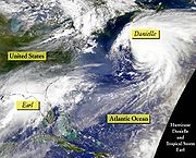
remnants of Earl significantly intensified before passing over Newfoundland on September 6. The remnants were absorbed by former Hurricane Danielle
two days later.
Moderate beach erosion occurred along the coasts of Louisiana, Mississippi, Alabama, and Florida as waves reached 20 ft (6.1 m). Throughout Florida, nearly 2,000 homes were damaged and a few were destroyed. Severe flooding caused by storm surge
and heavy rains was the main cause of damage in the state. Offshore, two men drowned after their boat capsized during the storm. A minor tornado outbreak
took place in relation to Earl in Florida, Georgia, South Carolina, and North Carolina. A tornado in South Carolina killed one person after completely destroying the occupants home. In all, three people were killed by Earl and damages were $79 million (1998 USD; $104.4 million 2009 USD).
that moved off the west coast of Africa on August 17. By August 23, a weak area of low pressure
developed within the wave and well-developed convective activity
was present as it tracked through the Lesser Antilles
. Once in the Caribbean Sea
, strong wind shear
produced by the outflow
of Hurricane Bonnie
inhibited further development of the system. As it remained well-defined, satellites easily followed the low pressure into the Gulf of Mexico
. By August 31, the storm had become sufficiently organized for the National Hurricane Center
(NHC) to classify it as Tropical Depression Five. At this time, the depression was located roughly half-way between Merida and Tampico, Mexico.
Operationally, the NHC immediately classified the system as Tropical Storm Earl based on a Hurricane Hunter Reconnaissance mission that found flight-level winds of 49 mph (79 km/h), corresponding to surface winds of 40 mph (65 km/h). Due to the existence of multiple circulation centers, the initial movement of the storm was uncertain, but forecasters anticipated a general northward movement. In post-season analysis, it was determined that the system intensified into Tropical Storm Earl while located about 575 miles (925 km) south-southwest of New Orleans. Initial advisories on Earl relocated the center of circulation several times before focusing on the true circulation center.
By September 1, the storm began to consolidate, with reconnaissance flights finding an elongated center and surface winds of 60 mph (95 km/h). Moderate wind shear inhibited convective development in the western portion; however, outflow in other areas of the storm improved, leading to further development. A northwest track, fully identified by this time as a mid-tropospheric
ridge
located over Florida
, strengthened. Remaining disorganized, Earl continued to intensify as the center of circulation was located close to deep convection. The NHC stated in their fifth advisory on the storm that Earl did not appear to be fully tropical due to the lack of organization. Around 1200 UTC on September 2, Earl intensified into a hurricane despite having an atypical structure; the wind field of the storm was asymmetric and the strongest winds were located well to the southeast of the center.
 Several hours after becoming a hurricane, Earl further intensified into a Category 2 hurricane on the Saffir–Simpson Hurricane Scale; this observation was based on a flight-level winds of 119 mph (192 km/h), which corresponded to surface winds of 100 mph (155 km/h). The storm did not feature an eye
or partial eyewall. The central barometric pressure continued to fall despite the fact that the storm was beginning to weaken. Around 0000 UTC on September 3, the central pressure decreased to 985 mbar (hPa; 29.09 inHg); however, winds also decreased to 90 mph (150 km/h). As Earl neared landfall
, cloud tops significantly warmed, indicating weakening, and the overall structure of the storm became less organized.
Around 0600 UTC (1:00 am EDT) on September 3, Hurricane Earl made landfall near Panama City, Florida
with winds of 80 mph (130 km/h). Shortly after landfall, the storm weakened to a tropical storm and rapidly accelerated as it quickly underwent an extratropical transition
. By this time the NHC issued their final advisory on Earl. Several hours later, Earl finished its transition and continued to rapidly track through the Southeast United States. After entering the Atlantic Ocean
, the remnants of Earl began re-intensify due to the effects of a baroclinic zone. Relatively cool sea surface temperatures near Atlantic Canada
prevented tropical development; however, during a 36-hour span, Earl rapidly intensified
, as the central barometric pressure decreased by 40 mbar (hPa; 1.18 inHg) to 957 mbar (hPa; 28.26 inHg). By the time the system made landfall over eastern Newfoundland, sustained winds had intensified to 65 mph (100 km/h). On September 8, the remnants of Earl significantly weakened and were soon absorbed by a larger extratropical cyclone associated with the remnants of Hurricane Danielle
.
 As Earl tracked towards the northeastern Gulf of Mexico on September 1, a hurricane warning
was issued for coastal areas between Pascagoula, Mississippi
and Cameron, Louisiana
. Additionally, hurricane watches extended out to Destin, Florida
and High Island, Texas
from the edges of the warning respectively. Early the next day, a tropical storm warning was issued for areas between Pascagoula, Mississippi and Destin, Florida. In response to the eastward movement of the hurricane, the hurricane watch and warning was discontinued for areas west of Morgan City, Louisiana
. Additionally, the hurricane warning was extended eastward to Destin, Florida, a tropical storm warning was issued east of Destin to Apalachicola, Florida
, and a tropical storm watch was declared for areas between Morgan City and Cameron, Louisiana. Several hours later, the hurricane warning was again extended eastward to the mouth of the Suwannee River
. All watches and warnings were discontinued for areas west of Pascagoula, Mississippi and due to the asymmetrical structure of Hurricane Earl, a tropical storm warning was issued as far south as the Florida Keys
. Continuing uncertainty in the track of Earl prompted the issuance of a hurricane watch and tropical storm warning for areas between Pascagoula, Mississippi and Grand Isle, Louisiana
, including the city of New Orleans. After Earl made landfall in Florida, all watches and warnings were discontinued in relation to the storm.
Offshore, several oil and natural gas rigs were evacuated due to the proximity of Earl. An estimated 10,000 workers were evacuated from both onshore and offshore rigs. The storm forced many Florida residences to evacuate, especially people living in the barrier islands along the Florida Gulf Coast. About 30 Air Force
jets from Eglin Air Force Base
were sent to Oklahoma
to protect them from the storm. A mandatory evacuation was issued for 20,000 residents in Leon County
as well as all barrier islands along the Florida coast due to the risk of substantial flooding. Franklin County
was briefly under a mandatory evacuation order on September 2, the reasons for the lifting of the order are unknown. State parks along the Florida Panhandle were also closed and highways became congested with thousands of residents and tourists evacuating the barrier islands.
Along the Louisiana coastline, voluntary evacuation orders were given out. A state of emergency
was declared for portions of southeast Louisiana as tides in relation to the storm were forecast to reach 7 to 10 ft (2.1 to 3 m). Emergency shelters were opened throughout Plaquemines Parish
, schools were closed in many areas, and the floodgates around New Orleans were shut. An estimated 5,000 people evacuated to inland areas throughout Louisiana. In Nueces County, Texas, work crews worked quickly to clear garbage along the streets and picked up trash cans to avoid possible problems with clogged drains. Throughout the Alabama and Mississippi coasts, schools were closed due to the storm.
 Ahead of Hurricane Earl's landfall in Florida, several tornadoes were spawned along the outer bands
of the storm. The first tornado to touch down was a brief F0
that caused no known damage. The second tornado, rated F1, caused moderate damage to three homes and two buildings that were under-construction along its 3 mi (4.8 km) path. During a 15-minute span, three brief F0 tornadoes touched down in unpopulated areas, causing minor tree damage. Several hours later, a strong F1 tornado touched down in Port Canaveral. The tornado damaged 14 cars, eight condominiums, four businesses, a mobile home, and a fire station. In all, the tornado caused $6 million in damages and injured one person. On St. George Island
, an F1 tornado damaged six homes, leaving $150,000 in damages. High waves, estimated at 16 to 20 ft (4.9 to 6.1 m) caused a boat to capsize off the coast of Panama City
, drowning both occupants.
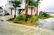 Upon making landfall in Florida early on September 3, Earl produced a storm surge
up to 12 ft (3.7 m) in the Big Bend
, inundating coastal communities. Torrential rains, peaking at 16.36 in (415.5 mm) around Panama City, fell throughout the Florida Panhandle
. Significant beach erosion was recorded in Walton County, Carrabelle Beach and Alligator Point. The most extensive damage occurred in Bay County
where 1,112 structures damaged by flooding and three were destroyed. In Panama City, upwards of 5 ft (1.5 m) of water flooded homes. An estimated 7,100 residents in Bay County lost power during the storm. Florida officials temporarily shut down numerous major roadways, including Florida State Road 77
due to high water. Portions of two roads in coastal Liberty County
were destroyed due to beach erosion. In Gulf County
, 300 homes were damaged by high winds and floodwaters. An estimated 8,700 people lost power in the county during the storm. At Port St. Joe, Earl's storm surge inundated 14 businesses and caused a water mane break in the Lighthouse Utilities facility. In Franklin County
, storm surge damaged 136 homes and 15 businesses and led to a temporary closure of the St. George Causeway. A lighthouse on St. George Island was also destroyed by the storm.
At least 50 people were stranded in Alligator Point after floodwaters washed out the main access route to the town. In Wakulla County
, 216 homes and businesses were damaged by high winds and flooding. Severe flooding in coastal Taylor County
caused significant damage in nine communities. County officials reported that 66 structures were damaged by Earl. Five homes were destroyed and 39 others were damaged by flooding in Dixie County
. In Highlands County
, one person was injured after being struck by lightning. On September 3, the strongest tornado spawned by Earl in Florida touched down in Citrus County
. Rated F2, the tornado tracked for 5 mi (8 km), destroying eight homes and damaging 24 others. Several trees and power lines were also downed. Two people were injured in one of the destroyed homes and damages from the tornado amounted to $500,000. In all, Hurricane Earl killed two people and caused $73 million (1998 USD; $96.5 million 2009 USD) in Florida.
 In Louisiana, moderate beach erosion occurred as tides reached 3.5 ft (1.1 m) above mean sea level. Rainfall was relatively light, peaking around 2 in (50.8 mm) in Morgan City, as only the outer bands
of Earl affected the state. The highest winds occurred along the coast, with sustained winds reaching 30 mph (45 km/h) and gusts reaching 44 mph (70.8 km/h) in Venice, Louisiana
. Only minimal damage resulted from the storm in Louisiana, with monetary losses amounting to $32,000. However, losses due to the large-scale evacuation of oil and natural gas rigs was estimated to be several million dollars. Earl had limited impacts in Mississippi, with only areas along the immediate coast recording tropical storm-force wind gusts. In Alabama, Earl produced moderate rainfall, with areas along the Georgia state line receiving more than 5 in (127 mm). Despite the center of Earl passing close to the state, winds were only recorded up to 40 mph (65 km/h), resulting in scattered power outages and downed trees. Portions of Alabama State Route 28
were temporarily shut down due to debris covering the road
. In all, damages in the state amounted to $120,000.
Ahead of Earl, an onshore flow related to the storm produced 6 to 8 ft (1.8 to 2.4 m) swells along the Georgia coast, causing significant damage to marinas. The Mar Lin Marina sustained the most damage from this event; all the docks were destroyed, 30 boats were damaged and six were destroyed. Damages to the marina and boats amounted to $1.3 million. Heavy rains fell throughout central areas of the state, with the highest amounts nearing 10 in (254 mm). Because Earl rapidly weakened upon landfall, the highest winds in Georgia only reached 54 mph (86.9 km/h). Numerous trees and power lines were downed, resulting in scattered power outages. Throughout Georgia, an estimated 10,400 people lost power due to Earl. Several streets were flooded due to the rains, resulting in traffic accidents. One tornado was spawned by Earl in Georgia; rated F2 on the Fujita scale
, the tornado tracked for 8 mi (12.9 km) in Screven County
. Estimated at 350 yd (320 m) in width, the tornado destroyed five mobile homes and a business, severely damaged 15 additional mobile homes and caused some damage to five others. Seven people were injured by the tornado and damages amounted to $435,000. Several major highways were temporarily closed due to high water or debris covering the road. Numerous homes sustained damage from fallen trees in several counties. In all, damages from Earl amounted to $2.3 million in Georgia.
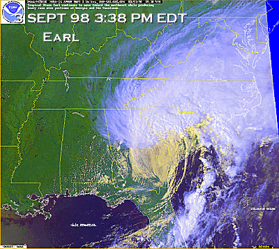 The extratropical remnants continued through the Southern United States, tracking through the Carolinas late on September 3. Sustained winds in South Carolina reached 50 mph (85 km/h) and gusted up to 70 mph (110 km/h). Widespread rainfall, generally amounting between 2 and 4 in (50.8 and 101.6 mm), fell in areas previously saturated by Hurricane Bonnie, this triggered minor flooding along roads. Inland, isolated amounts of 10 in (254 mm) of rain fell. The first tornado related to Earl touched down in Choppee, located in Georgetown County. The tornado was rated F0 and was only briefly on the ground before it dissipated. The second tornado to touch down in the state was also the strongest in relation to Earl. Rated F2, the tornado tracked for 18 mi (29 km) through Beaufort
and Colleton Counties, destroying 13 homes and damaging 13 others. One mobile home was flipped in the air and was completely destroyed once it hit the ground, instantly killing the occupant of the home. Numerous trees were uprooted and snapped along its path. In all, the tornado killed one person, injured four others and caused $360,000 in damages. A brief F1 tornado touched down several hours later, damaging the roof of a barn and uprooting several trees before dissipating. The most damaging tornado spawned by Earl was a 430 yd (393.2 m) wide, F2 tornado that struck the Fairlawn subdivision near Moncks Corner
. Along the tornado's 7 mi (11.3 km) track, 21 homes were destroyed and 73 others were damaged. Nine people sustained injuries due to the tornado and damages amounted to $2.8 million.
 Still recovering from Hurricane Bonnie, the remnants of Earl produced widespread rain over North Carolina, triggering flooding. Upwards of 6 in (152.4 mm) fell in localized areas, causing small streams to overflow their banks. In Union County
, up to 15 roads were shut down due to flooding, a few cars were also washed off roads at the height of the floods. In Charlotte
, several roads were flooded. The Carteret Community College
, which was severely damaged by Bonnie, was again damaged by Earl. High winds from the storm damaged temporary protective measures, allowing rain to flood the interior of the building, causing water damage to the structure and materials inside. In front of the Crystal Coast Civic Center, fabriform, installed to stabilize the beach, was damaged by the storm, resulting in significant beach erosion. Two short lived tornadoes touched down in North Carolina from Earl. The first, an F0, damaged at least 15 mobile homes, overturned sheds, destroyed a porch and two campers. No injuries resulted from the tornado and damage amounted to $50,000. The second and stronger of the two tornadoes, rated F1, only touched down for a few seconds; however, it destroyed one home and severely damaged a neighboring home. According to eye-witness reports, the tornado lifted the home 20 to 25 ft (6.1 to 7.6 m) off the ground before the home broke apart and fell to the ground.
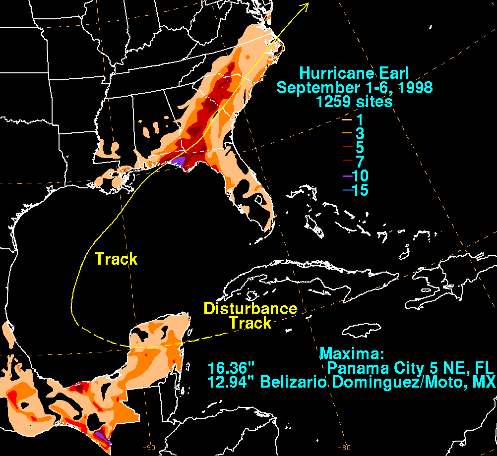
until early September 2. The highest rainfall total was reported from Belizario Dominguez/Moto, where 12.94 in (328.7 mm) of precipitation fell.
The extratropical remnants of Earl produced strong winds and heavy rains throughout Newfoundland and Nova Scotia
on September 6. Sustained winds were recorded up to 56 mph (90.1 km/h) and rains totaled between 2 and 4 in (50.8 and 101.6 mm) throughout Newfoundland. On Nova Scotia, rainfall peaked at 4.62 in (117.3 mm) on Cape Breton Island
. The highest recorded total on Newfoundland reached 3.54 in (89.9 mm) in northwestern areas of the island.
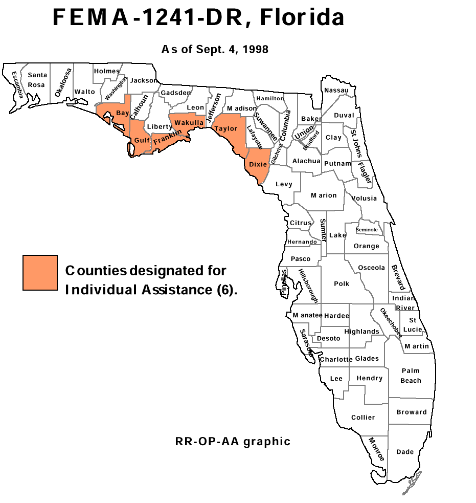 On September 4, President Bill Clinton
approved disaster declarations for six counties in Florida. Bay
, Dixie
, Franklin
, Gulf
, Taylor
, and Wakulla counties
were approved for Individual Assistance. Residents in the designated counties were eligible to receive federal funding for three months following the storm. By September 8, State Farm
had received 200 auto and 720 homeowners claims from the affected region, most of which were partial damage claims. Allstate
had received 80 auto and 587 homeowners claims from Florida and 540 claims from Georgia. Additionally, Nationwide
reported that up to 1,000 claims had been filed from Florida.
Following the impacts of Hurricane Opal
in 1995, Earl and later Hurricane Georges
, the state of Florida undertook a recovery project to restore the eroded beaches along the Panhandle coast. In October United States Department of Transportation
provided $2 million in funds to repair damaged and destroyed roads in Florida. On December 3, an additional $1.7 million was provided to repair funds. The United States Military allocated $2.2 million to repair damage from Hurricane Earl to training academies and naval ports. The Florida Senate provided $25,740 in emergency funds to Hurricane Earl victims. By the end of the disaster declaration, the Federal Emergency Management Agency
provided $1 million in public assistance and $600,000 in disaster mitigation.
Gulf of Mexico
The Gulf of Mexico is a partially landlocked ocean basin largely surrounded by the North American continent and the island of Cuba. It is bounded on the northeast, north and northwest by the Gulf Coast of the United States, on the southwest and south by Mexico, and on the southeast by Cuba. In...
late on August 31, 1998. Tracking towards the northwest, the storm quickly intensified into a hurricane on September 2 and made landfall early the next day near Panama City, Florida
Panama City, Florida
-Personal income:The median income for a household in the city was $31,572, and the median income for a family was $40,890. Males had a median income of $30,401 versus $21,431 for females. The per capita income for the city was $17,830...
. Rapidly tracking towards Atlantic Canada
Atlantic Canada
Atlantic Canada is the region of Canada comprising the four provinces located on the Atlantic coast, excluding Quebec: the three Maritime provinces – New Brunswick, Prince Edward Island, and Nova Scotia – and Newfoundland and Labrador...
, the extratropical
Extratropical cyclone
Extratropical cyclones, sometimes called mid-latitude cyclones or wave cyclones, are a group of cyclones defined as synoptic scale low pressure weather systems that occur in the middle latitudes of the Earth having neither tropical nor polar characteristics, and are connected with fronts and...
remnants of Earl significantly intensified before passing over Newfoundland on September 6. The remnants were absorbed by former Hurricane Danielle
Hurricane Danielle (1998)
Hurricane Danielle was the fourth named storm, second hurricane, and fourth most intense storm of the active 1998 Atlantic hurricane season, and was a long-tracking Cape Verde-type hurricane across the Atlantic Ocean that originated off the African coastline on August 21, reaching its peak...
two days later.
Moderate beach erosion occurred along the coasts of Louisiana, Mississippi, Alabama, and Florida as waves reached 20 ft (6.1 m). Throughout Florida, nearly 2,000 homes were damaged and a few were destroyed. Severe flooding caused by storm surge
Storm surge
A storm surge is an offshore rise of water associated with a low pressure weather system, typically tropical cyclones and strong extratropical cyclones. Storm surges are caused primarily by high winds pushing on the ocean's surface. The wind causes the water to pile up higher than the ordinary sea...
and heavy rains was the main cause of damage in the state. Offshore, two men drowned after their boat capsized during the storm. A minor tornado outbreak
Tornado outbreak
While there is no single agreed upon definition, generally at least 6-10 tornadoes produced by the same synoptic scale weather system is considered a tornado outbreak. The tornadoes usually occur within the same day, or continue into the early morning hours of the succeeding day, and within the...
took place in relation to Earl in Florida, Georgia, South Carolina, and North Carolina. A tornado in South Carolina killed one person after completely destroying the occupants home. In all, three people were killed by Earl and damages were $79 million (1998 USD; $104.4 million 2009 USD).
Meteorological history
Hurricane Earl originated out of a strong tropical waveTropical wave
Tropical waves, easterly waves, or tropical easterly waves, also known as African easterly waves in the Atlantic region, are a type of atmospheric trough, an elongated area of relatively low air pressure, oriented north to south, which move from east to west across the tropics causing areas of...
that moved off the west coast of Africa on August 17. By August 23, a weak area of low pressure
Low pressure area
A low-pressure area, or "low", is a region where the atmospheric pressure at sea level is below that of surrounding locations. Low-pressure systems form under areas of wind divergence which occur in upper levels of the troposphere. The formation process of a low-pressure area is known as...
developed within the wave and well-developed convective activity
Atmospheric convection
Atmospheric convection is the result of a parcel-environment instability, or temperature difference, layer in the atmosphere. Different lapse rates within dry and moist air lead to instability. Mixing of air during the day which expands the height of the planetary boundary layer leads to...
was present as it tracked through the Lesser Antilles
Lesser Antilles
The Lesser Antilles are a long, partly volcanic island arc in the Western Hemisphere. Most of its islands form the eastern boundary of the Caribbean Sea with the Atlantic Ocean, with the remainder located in the southern Caribbean just north of South America...
. Once in the Caribbean Sea
Caribbean Sea
The Caribbean Sea is a sea of the Atlantic Ocean located in the tropics of the Western hemisphere. It is bounded by Mexico and Central America to the west and southwest, to the north by the Greater Antilles, and to the east by the Lesser Antilles....
, strong wind shear
Wind shear
Wind shear, sometimes referred to as windshear or wind gradient, is a difference in wind speed and direction over a relatively short distance in the atmosphere...
produced by the outflow
Outflow (meteorology)
Outflow, in meteorology, is air that flows outwards from a storm system. It is associated with ridging, or anticyclonic flow. In the low levels of the troposphere, outflow radiates from thunderstorms in the form of a wedge of rain-cooled air, which is visible as a thin rope-like cloud on weather...
of Hurricane Bonnie
Hurricane Bonnie (1998)
Hurricane Bonnie was a major hurricane that made landfall in North Carolina, United States, inflicting severe crop damage. The second named storm, first hurricane, and first major hurricane of the 1998 Atlantic hurricane season, Bonnie developed from a tropical wave that emerged off the coast of...
inhibited further development of the system. As it remained well-defined, satellites easily followed the low pressure into the Gulf of Mexico
Gulf of Mexico
The Gulf of Mexico is a partially landlocked ocean basin largely surrounded by the North American continent and the island of Cuba. It is bounded on the northeast, north and northwest by the Gulf Coast of the United States, on the southwest and south by Mexico, and on the southeast by Cuba. In...
. By August 31, the storm had become sufficiently organized for the National Hurricane Center
National Hurricane Center
The National Hurricane Center , located at Florida International University in Miami, Florida, is the division of the National Weather Service responsible for tracking and predicting weather systems within the tropics between the Prime Meridian and the 140th meridian west poleward to the 30th...
(NHC) to classify it as Tropical Depression Five. At this time, the depression was located roughly half-way between Merida and Tampico, Mexico.
Operationally, the NHC immediately classified the system as Tropical Storm Earl based on a Hurricane Hunter Reconnaissance mission that found flight-level winds of 49 mph (79 km/h), corresponding to surface winds of 40 mph (65 km/h). Due to the existence of multiple circulation centers, the initial movement of the storm was uncertain, but forecasters anticipated a general northward movement. In post-season analysis, it was determined that the system intensified into Tropical Storm Earl while located about 575 miles (925 km) south-southwest of New Orleans. Initial advisories on Earl relocated the center of circulation several times before focusing on the true circulation center.
By September 1, the storm began to consolidate, with reconnaissance flights finding an elongated center and surface winds of 60 mph (95 km/h). Moderate wind shear inhibited convective development in the western portion; however, outflow in other areas of the storm improved, leading to further development. A northwest track, fully identified by this time as a mid-tropospheric
Troposphere
The troposphere is the lowest portion of Earth's atmosphere. It contains approximately 80% of the atmosphere's mass and 99% of its water vapor and aerosols....
ridge
High pressure area
A high-pressure area is a region where the atmospheric pressure at the surface of the planet is greater than its surrounding environment. Winds within high-pressure areas flow outward due to the higher density air near their center and friction with land...
located over Florida
Florida
Florida is a state in the southeastern United States, located on the nation's Atlantic and Gulf coasts. It is bordered to the west by the Gulf of Mexico, to the north by Alabama and Georgia and to the east by the Atlantic Ocean. With a population of 18,801,310 as measured by the 2010 census, it...
, strengthened. Remaining disorganized, Earl continued to intensify as the center of circulation was located close to deep convection. The NHC stated in their fifth advisory on the storm that Earl did not appear to be fully tropical due to the lack of organization. Around 1200 UTC on September 2, Earl intensified into a hurricane despite having an atypical structure; the wind field of the storm was asymmetric and the strongest winds were located well to the southeast of the center.
Eye (cyclone)
The eye is a region of mostly calm weather found at the center of strong tropical cyclones. The eye of a storm is a roughly circular area and typically 30–65 km in diameter. It is surrounded by the eyewall, a ring of towering thunderstorms where the second most severe weather of a cyclone...
or partial eyewall. The central barometric pressure continued to fall despite the fact that the storm was beginning to weaken. Around 0000 UTC on September 3, the central pressure decreased to 985 mbar (hPa; 29.09 inHg); however, winds also decreased to 90 mph (150 km/h). As Earl neared landfall
Landfall (meteorology)
Landfall is the event of a tropical cyclone or a waterspout coming onto land after being over water. When a waterspout makes landfall it is reclassified as a tornado, which can then cause damage inland...
, cloud tops significantly warmed, indicating weakening, and the overall structure of the storm became less organized.
Around 0600 UTC (1:00 am EDT) on September 3, Hurricane Earl made landfall near Panama City, Florida
Panama City, Florida
-Personal income:The median income for a household in the city was $31,572, and the median income for a family was $40,890. Males had a median income of $30,401 versus $21,431 for females. The per capita income for the city was $17,830...
with winds of 80 mph (130 km/h). Shortly after landfall, the storm weakened to a tropical storm and rapidly accelerated as it quickly underwent an extratropical transition
Extratropical cyclone
Extratropical cyclones, sometimes called mid-latitude cyclones or wave cyclones, are a group of cyclones defined as synoptic scale low pressure weather systems that occur in the middle latitudes of the Earth having neither tropical nor polar characteristics, and are connected with fronts and...
. By this time the NHC issued their final advisory on Earl. Several hours later, Earl finished its transition and continued to rapidly track through the Southeast United States. After entering the Atlantic Ocean
Atlantic Ocean
The Atlantic Ocean is the second-largest of the world's oceanic divisions. With a total area of about , it covers approximately 20% of the Earth's surface and about 26% of its water surface area...
, the remnants of Earl began re-intensify due to the effects of a baroclinic zone. Relatively cool sea surface temperatures near Atlantic Canada
Atlantic Canada
Atlantic Canada is the region of Canada comprising the four provinces located on the Atlantic coast, excluding Quebec: the three Maritime provinces – New Brunswick, Prince Edward Island, and Nova Scotia – and Newfoundland and Labrador...
prevented tropical development; however, during a 36-hour span, Earl rapidly intensified
Rapid deepening
Rapid deepening, also known as rapid intensification, is a meteorological condition that occurs when the minimum sea-level atmospheric pressure of a tropical cyclone decreases drastically in a short period of time. The National Weather Service describes rapid deepening as a decrease of...
, as the central barometric pressure decreased by 40 mbar (hPa; 1.18 inHg) to 957 mbar (hPa; 28.26 inHg). By the time the system made landfall over eastern Newfoundland, sustained winds had intensified to 65 mph (100 km/h). On September 8, the remnants of Earl significantly weakened and were soon absorbed by a larger extratropical cyclone associated with the remnants of Hurricane Danielle
Hurricane Danielle (1998)
Hurricane Danielle was the fourth named storm, second hurricane, and fourth most intense storm of the active 1998 Atlantic hurricane season, and was a long-tracking Cape Verde-type hurricane across the Atlantic Ocean that originated off the African coastline on August 21, reaching its peak...
.
Preparations
Tropical cyclone warnings and watches
Warnings and watches are two levels of alert issued by national weather forecasting bodies to coastal areas threatened by the imminent approach of a tropical cyclone of tropical storm or hurricane intensity. They are notices to the local population and civil authorities to make appropriate...
was issued for coastal areas between Pascagoula, Mississippi
Pascagoula, Mississippi
Pascagoula is a city in Jackson County, Mississippi, United States. It is the principal city of the Pascagoula, Mississippi Metropolitan Statistical Area, as a part of the Gulfport–Biloxi–Pascagoula, Mississippi Combined Statistical Area. The population was 26,200 at the 2000 census...
and Cameron, Louisiana
Cameron, Louisiana
Cameron is a census-designated place in and the parish seat of Cameron Parish, Louisiana, United States. The population was 1,965 at the 2000 census. It is part of the Lake Charles Metropolitan Statistical Area...
. Additionally, hurricane watches extended out to Destin, Florida
Destin, Florida
Destin is a city located in Okaloosa County, Florida. It is a principal city of the Fort Walton Beach-Crestview-Destin, Florida Metropolitan Statistical Area.Located on Florida's Emerald Coast, Destin is known for its white beaches and emerald green waters...
and High Island, Texas
High Island, Texas
High Island is an unincorporated area located in the Bolivar Peninsula census-designated place, Galveston County, Texas, United States. The community is located in the extreme eastern part of the county on Bolivar Peninsula, less than one mile from Chambers County and less than two miles from...
from the edges of the warning respectively. Early the next day, a tropical storm warning was issued for areas between Pascagoula, Mississippi and Destin, Florida. In response to the eastward movement of the hurricane, the hurricane watch and warning was discontinued for areas west of Morgan City, Louisiana
Morgan City, Louisiana
Morgan City is a city in St. Martin and St. Mary parishes in the U.S. state of Louisiana. The population was 12,404 at the 2010 census....
. Additionally, the hurricane warning was extended eastward to Destin, Florida, a tropical storm warning was issued east of Destin to Apalachicola, Florida
Apalachicola, Florida
Apalachicola is a city in Franklin County, Florida, on US 98 about southwest of Tallahassee. The population was 2,334 at the 2000 census. The 2005 census estimated the city's population at 2,340...
, and a tropical storm watch was declared for areas between Morgan City and Cameron, Louisiana. Several hours later, the hurricane warning was again extended eastward to the mouth of the Suwannee River
Suwannee River
The Suwannee River is a major river of southern Georgia and northern Florida in the United States. It is a wild blackwater river, about long. The Suwannee River is the site of the prehistoric Suwannee Straits which separated peninsular Florida from the panhandle.-Geography:The river rises in the...
. All watches and warnings were discontinued for areas west of Pascagoula, Mississippi and due to the asymmetrical structure of Hurricane Earl, a tropical storm warning was issued as far south as the Florida Keys
Florida Keys
The Florida Keys are a coral archipelago in southeast United States. They begin at the southeastern tip of the Florida peninsula, about south of Miami, and extend in a gentle arc south-southwest and then westward to Key West, the westernmost of the inhabited islands, and on to the uninhabited Dry...
. Continuing uncertainty in the track of Earl prompted the issuance of a hurricane watch and tropical storm warning for areas between Pascagoula, Mississippi and Grand Isle, Louisiana
Grand Isle, Louisiana
Grand Isle is a town in Jefferson Parish, Louisiana, located on a barrier island of the same name in the Gulf of Mexico. The island is at the mouth of Barataria Bay where it meets the gulf. As of the 2000 census, the town population was 1,541; during summers, the population sometimes increases to...
, including the city of New Orleans. After Earl made landfall in Florida, all watches and warnings were discontinued in relation to the storm.
Offshore, several oil and natural gas rigs were evacuated due to the proximity of Earl. An estimated 10,000 workers were evacuated from both onshore and offshore rigs. The storm forced many Florida residences to evacuate, especially people living in the barrier islands along the Florida Gulf Coast. About 30 Air Force
United States Air Force
The United States Air Force is the aerial warfare service branch of the United States Armed Forces and one of the American uniformed services. Initially part of the United States Army, the USAF was formed as a separate branch of the military on September 18, 1947 under the National Security Act of...
jets from Eglin Air Force Base
Eglin Air Force Base
Eglin Air Force Base is a United States Air Force base located approximately 3 miles southwest of Valparaiso, Florida in Okaloosa County....
were sent to Oklahoma
Oklahoma
Oklahoma is a state located in the South Central region of the United States of America. With an estimated 3,751,351 residents as of the 2010 census and a land area of 68,667 square miles , Oklahoma is the 28th most populous and 20th-largest state...
to protect them from the storm. A mandatory evacuation was issued for 20,000 residents in Leon County
Leon County, Florida
Leon County is a county located in the state of Florida, named after the Spanish explorer Juan Ponce de León. At the 2010 Census, the population was 275,487. The county seat of Leon County is Tallahassee which also serves as the state capital. The county seat is home to two of Florida's major...
as well as all barrier islands along the Florida coast due to the risk of substantial flooding. Franklin County
Franklin County, Florida
Franklin County is a coastal county located in the panhandle of the U.S. state of Florida. As of 2000, the population was 11,057. The U.S. Census Bureau 2005 estimate for the county is 11,177...
was briefly under a mandatory evacuation order on September 2, the reasons for the lifting of the order are unknown. State parks along the Florida Panhandle were also closed and highways became congested with thousands of residents and tourists evacuating the barrier islands.
Along the Louisiana coastline, voluntary evacuation orders were given out. A state of emergency
State of emergency
A state of emergency is a governmental declaration that may suspend some normal functions of the executive, legislative and judicial powers, alert citizens to change their normal behaviours, or order government agencies to implement emergency preparedness plans. It can also be used as a rationale...
was declared for portions of southeast Louisiana as tides in relation to the storm were forecast to reach 7 to 10 ft (2.1 to 3 m). Emergency shelters were opened throughout Plaquemines Parish
Plaquemines Parish, Louisiana
Plaquemines Parish is the parish with the most combined land and water area in the U.S. state of Louisiana. The parish seat is Pointe à la Hache...
, schools were closed in many areas, and the floodgates around New Orleans were shut. An estimated 5,000 people evacuated to inland areas throughout Louisiana. In Nueces County, Texas, work crews worked quickly to clear garbage along the streets and picked up trash cans to avoid possible problems with clogged drains. Throughout the Alabama and Mississippi coasts, schools were closed due to the storm.
Impact
Throughout the Southeast United States, Hurricane Earl killed three people and caused $79 million (1998 USD; $104.4 million 2009 USD) in damages.Florida
Rainband
A rainband is a cloud and precipitation structure associated with an area of rainfall which is significantly elongated. Rainbands can be stratiform or convective, and are generated by differences in temperature. When noted on weather radar imagery, this precipitation elongation is referred to as...
of the storm. The first tornado to touch down was a brief F0
Fujita scale
The Fujita scale , or Fujita-Pearson scale, is a scale for rating tornado intensity, based primarily on the damage tornadoes inflict on human-built structures and vegetation...
that caused no known damage. The second tornado, rated F1, caused moderate damage to three homes and two buildings that were under-construction along its 3 mi (4.8 km) path. During a 15-minute span, three brief F0 tornadoes touched down in unpopulated areas, causing minor tree damage. Several hours later, a strong F1 tornado touched down in Port Canaveral. The tornado damaged 14 cars, eight condominiums, four businesses, a mobile home, and a fire station. In all, the tornado caused $6 million in damages and injured one person. On St. George Island
St. George Island
St. George Island is an island in the northern Gulf of Mexico. It is a part of Franklin County, Florida.-Physical characteristics:St. George is a barrier island, long and wide at its widest point. St. George Island is adjacent to Cape St. George Island...
, an F1 tornado damaged six homes, leaving $150,000 in damages. High waves, estimated at 16 to 20 ft (4.9 to 6.1 m) caused a boat to capsize off the coast of Panama City
Panama City, Florida
-Personal income:The median income for a household in the city was $31,572, and the median income for a family was $40,890. Males had a median income of $30,401 versus $21,431 for females. The per capita income for the city was $17,830...
, drowning both occupants.
Storm surge
A storm surge is an offshore rise of water associated with a low pressure weather system, typically tropical cyclones and strong extratropical cyclones. Storm surges are caused primarily by high winds pushing on the ocean's surface. The wind causes the water to pile up higher than the ordinary sea...
up to 12 ft (3.7 m) in the Big Bend
Big Bend (Florida)
The Big Bend of Florida, U.S.A., is an informal region of the state with no official surveyed boundary. It includes part of the counties of the Florida Panhandle. Geologists prefer to characterize Florida’s Big Bend as the drowned karst section of the coast that occurs between the mouth of the...
, inundating coastal communities. Torrential rains, peaking at 16.36 in (415.5 mm) around Panama City, fell throughout the Florida Panhandle
Florida Panhandle
The Florida Panhandle, an informal, unofficial term for the northwestern part of Florida, is a strip of land roughly 200 miles long and 50 to 100 miles wide , lying between Alabama on the north and the west, Georgia also on the north, and the Gulf of Mexico to the south. Its eastern boundary is...
. Significant beach erosion was recorded in Walton County, Carrabelle Beach and Alligator Point. The most extensive damage occurred in Bay County
Bay County, Florida
Bay County is a county located in the U.S. state of Florida. The U.S. Census Bureau 2006 estimate for the county is 163,505 . Its county seat is Panama City, Florida. The county is best known for its white sand beaches and crystal blue water, where large pods of dolphins swim year-round...
where 1,112 structures damaged by flooding and three were destroyed. In Panama City, upwards of 5 ft (1.5 m) of water flooded homes. An estimated 7,100 residents in Bay County lost power during the storm. Florida officials temporarily shut down numerous major roadways, including Florida State Road 77
Florida State Road 77
State Road 77 is a major north–south artery in Florida's Panhandle connecting Panama City, Florida to the south with Alabama State Route 109 and Dothan, Alabama to the north....
due to high water. Portions of two roads in coastal Liberty County
Liberty County, Florida
Liberty County is a county located in the state of Florida. Its population was estimated in 2005 as 7,733. Its most populous incorporated area and county seat is Bristol....
were destroyed due to beach erosion. In Gulf County
Gulf County, Florida
Gulf County is a county located in the panhandle of the U.S. state of Florida. As of 2000, the population was 13,332. The U.S. Census Bureau 2005 estimate for the county is 13,975 . Its county seat is Port St. Joe.- History :...
, 300 homes were damaged by high winds and floodwaters. An estimated 8,700 people lost power in the county during the storm. At Port St. Joe, Earl's storm surge inundated 14 businesses and caused a water mane break in the Lighthouse Utilities facility. In Franklin County
Franklin County, Florida
Franklin County is a coastal county located in the panhandle of the U.S. state of Florida. As of 2000, the population was 11,057. The U.S. Census Bureau 2005 estimate for the county is 11,177...
, storm surge damaged 136 homes and 15 businesses and led to a temporary closure of the St. George Causeway. A lighthouse on St. George Island was also destroyed by the storm.
At least 50 people were stranded in Alligator Point after floodwaters washed out the main access route to the town. In Wakulla County
Wakulla County, Florida
Wakulla County is a county located in the U.S. state of Florida. As of 2000, the population was 22,863. The U.S. Census Bureau 2005 estimate for the county was 28,212 people...
, 216 homes and businesses were damaged by high winds and flooding. Severe flooding in coastal Taylor County
Taylor County, Florida
Taylor County is a county located in the state of Florida. As of 2000, the population was 19,256. The U.S. Census Bureau 2005 estimate for the county was 19,622 . Its county seat is Perry, Florida.- History :Taylor County was created in 1856...
caused significant damage in nine communities. County officials reported that 66 structures were damaged by Earl. Five homes were destroyed and 39 others were damaged by flooding in Dixie County
Dixie County, Florida
Dixie County is a county located in the U.S. state of Florida. As of 2000, the population was 13,827. The U.S. Census Bureau 2005 estimate for the county is 14,647 . Its county seat is Cross City, Florida.- History :...
. In Highlands County
Highlands County, Florida
Highlands County is a county located in the U.S. state of Florida. The U.S. Census Bureau 2006 estimate for the population was 97,346. Its county seat is Sebring, Florida. The county comprises the Sebring, Florida, Micropolitan Statistical Area.- History :...
, one person was injured after being struck by lightning. On September 3, the strongest tornado spawned by Earl in Florida touched down in Citrus County
Citrus County, Florida
Citrus County is a county located in the U.S. state of Florida. As of 2000, the population was 118,085. The U.S. Census Bureau 2008 estimate for the county was 141,416 . Its county seat is Inverness, Florida...
. Rated F2, the tornado tracked for 5 mi (8 km), destroying eight homes and damaging 24 others. Several trees and power lines were also downed. Two people were injured in one of the destroyed homes and damages from the tornado amounted to $500,000. In all, Hurricane Earl killed two people and caused $73 million (1998 USD; $96.5 million 2009 USD) in Florida.
Southeastern U.S.
Rainband
A rainband is a cloud and precipitation structure associated with an area of rainfall which is significantly elongated. Rainbands can be stratiform or convective, and are generated by differences in temperature. When noted on weather radar imagery, this precipitation elongation is referred to as...
of Earl affected the state. The highest winds occurred along the coast, with sustained winds reaching 30 mph (45 km/h) and gusts reaching 44 mph (70.8 km/h) in Venice, Louisiana
Venice, Louisiana
Venice is an unincorporated community in Plaquemines Parish, Louisiana, United States. It is 130 km south of New Orleans on the west bank of the Mississippi River at . It is the last community down the Mississippi accessible by automobile, and is the southern terminus of the Great River Road...
. Only minimal damage resulted from the storm in Louisiana, with monetary losses amounting to $32,000. However, losses due to the large-scale evacuation of oil and natural gas rigs was estimated to be several million dollars. Earl had limited impacts in Mississippi, with only areas along the immediate coast recording tropical storm-force wind gusts. In Alabama, Earl produced moderate rainfall, with areas along the Georgia state line receiving more than 5 in (127 mm). Despite the center of Earl passing close to the state, winds were only recorded up to 40 mph (65 km/h), resulting in scattered power outages and downed trees. Portions of Alabama State Route 28
Alabama State Route 28
State Route 28 is a long state route in the western part of the state. The route’s western terminus is at the junction with State Route 17 at Emelle in northwestern Sumter County, and the eastern terminus of the route is at the junction with State Route 21 near Darlington in eastern Wilcox...
were temporarily shut down due to debris covering the road
Road debris
Road debris, a form of road hazard, is debris on or off a road. Road debris includes substances, materials, and objects that are foreign to the normal roadway environment...
. In all, damages in the state amounted to $120,000.
Ahead of Earl, an onshore flow related to the storm produced 6 to 8 ft (1.8 to 2.4 m) swells along the Georgia coast, causing significant damage to marinas. The Mar Lin Marina sustained the most damage from this event; all the docks were destroyed, 30 boats were damaged and six were destroyed. Damages to the marina and boats amounted to $1.3 million. Heavy rains fell throughout central areas of the state, with the highest amounts nearing 10 in (254 mm). Because Earl rapidly weakened upon landfall, the highest winds in Georgia only reached 54 mph (86.9 km/h). Numerous trees and power lines were downed, resulting in scattered power outages. Throughout Georgia, an estimated 10,400 people lost power due to Earl. Several streets were flooded due to the rains, resulting in traffic accidents. One tornado was spawned by Earl in Georgia; rated F2 on the Fujita scale
Fujita scale
The Fujita scale , or Fujita-Pearson scale, is a scale for rating tornado intensity, based primarily on the damage tornadoes inflict on human-built structures and vegetation...
, the tornado tracked for 8 mi (12.9 km) in Screven County
Screven County, Georgia
Screven County is a county located in the U.S. state of Georgia. As of 2000, the population was 15,374. The 2007 Census Estimate shows a population of 15,037...
. Estimated at 350 yd (320 m) in width, the tornado destroyed five mobile homes and a business, severely damaged 15 additional mobile homes and caused some damage to five others. Seven people were injured by the tornado and damages amounted to $435,000. Several major highways were temporarily closed due to high water or debris covering the road. Numerous homes sustained damage from fallen trees in several counties. In all, damages from Earl amounted to $2.3 million in Georgia.
Beaufort County, South Carolina
-National protected areas:*Ernest F. Hollings ACE Basin National Wildlife Refuge *Pinckney Island National Wildlife Refuge-Demographics:As of the census of 2000, there were 155,215 people, 45,532 households, and 33,056 families residing in the county. The population density was 206 people per...
and Colleton Counties, destroying 13 homes and damaging 13 others. One mobile home was flipped in the air and was completely destroyed once it hit the ground, instantly killing the occupant of the home. Numerous trees were uprooted and snapped along its path. In all, the tornado killed one person, injured four others and caused $360,000 in damages. A brief F1 tornado touched down several hours later, damaging the roof of a barn and uprooting several trees before dissipating. The most damaging tornado spawned by Earl was a 430 yd (393.2 m) wide, F2 tornado that struck the Fairlawn subdivision near Moncks Corner
Moncks Corner, South Carolina
Moncks Corner is a town in and the county seat of Berkeley County, South Carolina, United States. The population was 5,952 at the 2000 census....
. Along the tornado's 7 mi (11.3 km) track, 21 homes were destroyed and 73 others were damaged. Nine people sustained injuries due to the tornado and damages amounted to $2.8 million.
Union County, North Carolina
-Demographics:As of the census of 2000, there were 123,677 people, 43,390 households, and 34,278 families residing in the county. The population density was 194 people per square mile . There were 45,695 housing units at an average density of 72 per square mile...
, up to 15 roads were shut down due to flooding, a few cars were also washed off roads at the height of the floods. In Charlotte
Charlotte, North Carolina
Charlotte is the largest city in the U.S. state of North Carolina and the seat of Mecklenburg County. In 2010, Charlotte's population according to the US Census Bureau was 731,424, making it the 17th largest city in the United States based on population. The Charlotte metropolitan area had a 2009...
, several roads were flooded. The Carteret Community College
Carteret Community College
Carteret Community College is a community college in Morehead City, North Carolina, USA. It serves Carteret County, North Carolina.Founded in 1963, Carteret Community College is one of 59 institutions comprising the N.C. Community College System...
, which was severely damaged by Bonnie, was again damaged by Earl. High winds from the storm damaged temporary protective measures, allowing rain to flood the interior of the building, causing water damage to the structure and materials inside. In front of the Crystal Coast Civic Center, fabriform, installed to stabilize the beach, was damaged by the storm, resulting in significant beach erosion. Two short lived tornadoes touched down in North Carolina from Earl. The first, an F0, damaged at least 15 mobile homes, overturned sheds, destroyed a porch and two campers. No injuries resulted from the tornado and damage amounted to $50,000. The second and stronger of the two tornadoes, rated F1, only touched down for a few seconds; however, it destroyed one home and severely damaged a neighboring home. According to eye-witness reports, the tornado lifted the home 20 to 25 ft (6.1 to 7.6 m) off the ground before the home broke apart and fell to the ground.
Elsewhere
The initial tropical disturbance passed through the Yucatán Peninsula on August 29 and inflow bands to the south of Earl continued rainfall across southeast MexicoMexico
The United Mexican States , commonly known as Mexico , is a federal constitutional republic in North America. It is bordered on the north by the United States; on the south and west by the Pacific Ocean; on the southeast by Guatemala, Belize, and the Caribbean Sea; and on the east by the Gulf of...
until early September 2. The highest rainfall total was reported from Belizario Dominguez/Moto, where 12.94 in (328.7 mm) of precipitation fell.
The extratropical remnants of Earl produced strong winds and heavy rains throughout Newfoundland and Nova Scotia
Nova Scotia
Nova Scotia is one of Canada's three Maritime provinces and is the most populous province in Atlantic Canada. The name of the province is Latin for "New Scotland," but "Nova Scotia" is the recognized, English-language name of the province. The provincial capital is Halifax. Nova Scotia is the...
on September 6. Sustained winds were recorded up to 56 mph (90.1 km/h) and rains totaled between 2 and 4 in (50.8 and 101.6 mm) throughout Newfoundland. On Nova Scotia, rainfall peaked at 4.62 in (117.3 mm) on Cape Breton Island
Cape Breton Island
Cape Breton Island is an island on the Atlantic coast of North America. It likely corresponds to the word Breton, the French demonym for Brittany....
. The highest recorded total on Newfoundland reached 3.54 in (89.9 mm) in northwestern areas of the island.
Aftermath
Bill Clinton
William Jefferson "Bill" Clinton is an American politician who served as the 42nd President of the United States from 1993 to 2001. Inaugurated at age 46, he was the third-youngest president. He took office at the end of the Cold War, and was the first president of the baby boomer generation...
approved disaster declarations for six counties in Florida. Bay
Bay County, Florida
Bay County is a county located in the U.S. state of Florida. The U.S. Census Bureau 2006 estimate for the county is 163,505 . Its county seat is Panama City, Florida. The county is best known for its white sand beaches and crystal blue water, where large pods of dolphins swim year-round...
, Dixie
Dixie County, Florida
Dixie County is a county located in the U.S. state of Florida. As of 2000, the population was 13,827. The U.S. Census Bureau 2005 estimate for the county is 14,647 . Its county seat is Cross City, Florida.- History :...
, Franklin
Franklin County, Florida
Franklin County is a coastal county located in the panhandle of the U.S. state of Florida. As of 2000, the population was 11,057. The U.S. Census Bureau 2005 estimate for the county is 11,177...
, Gulf
Gulf County, Florida
Gulf County is a county located in the panhandle of the U.S. state of Florida. As of 2000, the population was 13,332. The U.S. Census Bureau 2005 estimate for the county is 13,975 . Its county seat is Port St. Joe.- History :...
, Taylor
Taylor County, Florida
Taylor County is a county located in the state of Florida. As of 2000, the population was 19,256. The U.S. Census Bureau 2005 estimate for the county was 19,622 . Its county seat is Perry, Florida.- History :Taylor County was created in 1856...
, and Wakulla counties
Wakulla County, Florida
Wakulla County is a county located in the U.S. state of Florida. As of 2000, the population was 22,863. The U.S. Census Bureau 2005 estimate for the county was 28,212 people...
were approved for Individual Assistance. Residents in the designated counties were eligible to receive federal funding for three months following the storm. By September 8, State Farm
State farm
State farm can refer to:*Sovkhoz, a type of state-owned farm in the Soviet Union*Volkseigenes Gut, a type of state-owned farm in East Germany*Państwowe Gospodarstwo Rolne, a type of state-owned farm in People's Republic of Poland...
had received 200 auto and 720 homeowners claims from the affected region, most of which were partial damage claims. Allstate
Allstate
The Allstate Corporation is the second-largest personal lines insurer in the United States and the largest that is publicly held. The company also has personal lines insurance operations in Canada. Allstate was founded in 1931 as part of Sears, Roebuck and Co., and was spun off in 1993...
had received 80 auto and 587 homeowners claims from Florida and 540 claims from Georgia. Additionally, Nationwide
Nationwide Mutual Insurance Company
Nationwide Mutual Insurance Company & Affiliated Companies is a group of large U.S. insurance and financial services companies based in Columbus...
reported that up to 1,000 claims had been filed from Florida.
Following the impacts of Hurricane Opal
Hurricane Opal
Hurricane Opal was a Category 4 hurricane that formed in the Gulf of Mexico in September 1995.Opal was the ninth hurricane and the strongest of the abnormally active 1995 Atlantic hurricane season...
in 1995, Earl and later Hurricane Georges
Hurricane Georges
Hurricane Georges was a very destructive, powerful and long-lived Cape Verde-type Category 4 hurricane. Georges was the seventh tropical storm, fourth hurricane, and second major hurricane of the 1998 Atlantic hurricane season...
, the state of Florida undertook a recovery project to restore the eroded beaches along the Panhandle coast. In October United States Department of Transportation
United States Department of Transportation
The United States Department of Transportation is a federal Cabinet department of the United States government concerned with transportation. It was established by an act of Congress on October 15, 1966, and began operation on April 1, 1967...
provided $2 million in funds to repair damaged and destroyed roads in Florida. On December 3, an additional $1.7 million was provided to repair funds. The United States Military allocated $2.2 million to repair damage from Hurricane Earl to training academies and naval ports. The Florida Senate provided $25,740 in emergency funds to Hurricane Earl victims. By the end of the disaster declaration, the Federal Emergency Management Agency
Federal Emergency Management Agency
The Federal Emergency Management Agency is an agency of the United States Department of Homeland Security, initially created by Presidential Reorganization Plan No. 1 of 1978 and implemented by two Executive Orders...
provided $1 million in public assistance and $600,000 in disaster mitigation.
See also
- Other storms of the same name