
.gif)
Tropical Storm Beryl (1988)
Encyclopedia
Tropical Storm Beryl was an unusual Atlantic
tropical cyclone
that formed over southeastern Louisiana
in August 1988. The second tropical storm of the 1988 Atlantic hurricane season
, Beryl developed from a slow-moving trough
of low pressure on August 8. It tracked southeastward into the coastal waters of eastern Louisiana, and Beryl reached peak winds of 50 mph (85 km/h) while located about 75 miles (120 km) southeast of New Orleans
. The storm turned to the northwest over Louisiana and Texas
, and slowly dissipated. The remnants of Beryl continued northward into the central United States
, dropping some rainfall and providing relief to a severe heat wave.
Due to its slow motion, Beryl dropped heavy amounts of rainfall, peaking at 16.09 inches (408 mm) on Dauphin Island in Alabama
. The rainfall caused some reports of flooding, while prolonged durations of rough waves resulted in severe beach erosion. The waves capsized a boat in Mobile Bay
, killing one of its passengers. Overall damage was minor, totaling about $3 million (1988 USD, $5.46 million 2009 USD).
of low pressure emerged into the northeast Gulf of Mexico
on August 1. Under weak steering currents, the trough drifted westward, and slowly became better defined with the formation of a circulation in the mid- through upper-levels of the atmosphere. An upper-level low developed over Texas
, providing unfavorable amounts of vertical wind shear
. A surface circulation was first evident on satellite imagery on August 4 just off the coast of Mississippi
, and for several days it remained nearly stationary over the Mississippi Sound
. As the upper-level low over Texas drifted southwestward, an anticyclone
developed over the system, with the circulation becoming better defined and more vertically aligned. On August 7, the system drifted into southeastern Louisiana
. It continued to become better organized, and on August 8 it developed into Tropical Depression Three while located near the northern coast of Lake Pontchartrain
. This is unusual in that tropical cyclones rarely form over land.
Upon becoming a tropical cyclone, the depression drifted southeastward, and within hours of its formation it emerged into the Gulf of Mexico. Based on ship reports and observations
from oil rig
s, it is estimated the depression intensified into Tropical Storm Beryl at 1000 UTC on August 8 while located just offshore coastal Louisiana. Conditions remained favorable for further intensification, with the circulation located over warm waters and maintaining well-defined outflow; early on August 9 Beryl attained its peak intensity of 50 mph while located about 75 miles (120 km) southeast of New Orleans
. Shortly thereafter, a trough from the northwest dissipated the anticyclone and resulted in a steady northwest motion very near where the cyclone originally moved offshore. Beryl maintained tropical storm status for about 18 hours before weakening to a tropical depression over central Louisiana. It turned to the northwest, and the surface circulation dissipated on August 10 while located a short distance south of Shreveport, Louisiana
. The surface low pressure area crossed into north Texas
before dissipating early on August 12, while its upper-level circulation turned northward into Oklahoma
before being merged by an approaching trough.
issued a tropical storm warning
from the mouth of the Mississippi River
to Pensacola, Florida
. Six hours later, the warning was extended westward to Morgan City, Louisiana
. The threat of Beryl prompted some voluntary evacuations in St. Bernard Parish
in Louisiana
, and also forced the evacuations of thousands from offshore oil rigs. Officials advised small craft to remain at port from Port O'Connor, Texas
to Pensacola, Florida
.
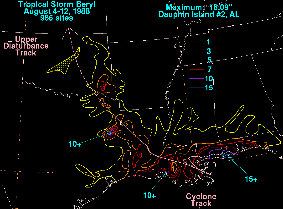 Rainfall from the storm reached over 7 inches (175 mm) a short distance east of Pensacola, Florida
, though impact in the state was minor. Wind gusts peaked at 38 mph (61 km/h) in Pensacola. In Alabama
, Beryl produced sustained winds of 38 mph (61 km/h), with gusts to 54 mph (86 km/h), as well as above normal tides. The storm dropped heavy rainfall in coastal portions of Alabama, peaking at 16.09 inches (408 mm) on Dauphin Island. Rough waves overturned a shrimp boat in Mobile Bay
. A 15-year-old boy on the boat drowned, the only direct fatality from the storm. The boy's father, also on the boat, spent 24 hours in the water before being rescued by the United States Coast Guard
. The waves caused severe beach erosion along the coastline, with Dauphin Island losing 60 to 70 feet (18 to 21 m) of beach.
In Mississippi
, coastal areas reported heavy amounts of precipitation, reaching over 10 inches (250 mm) in Jackson County
. Sustained winds reached 47 mph (76 km/h) at Gulfport
, the strongest wind on a land station. Similar to Alabama, strong waves caused considerable beach erosion along portions of the coastline.
Beryl dropped rainfall across much of Louisiana
, peaking at over 10 inches (250 mm) near Morgan City
. The rainfall caused significant river flooding along the Biloxi River. Wind gusts were fairly light across the state, reaching 40 mph (65 km/h) in New Orleans
. The winds caused light tree damage, which resulted in some power outages. A storm surge of about 5 feet (1.5 m) caused some coastal flooding.
The remnants of Beryl produced locally heavy precipitation peaking at about 12 inches (300 mm) in east-central Texas
, resulting in some reports of flash flood
ing. The rainfall flooded some roads and also causes severe river flooding on the Angelina River
. Remnant moisture dropped about 5 inches (125 mm) of rain in southeast Oklahoma
and 3 inches (75 mm) in southwestern Arkansas
. Further inland, the remnants of Beryl cooled temperatures and provided relief to the severe heat wave in the central United States
.
Throughout its path, Beryl caused about $3 million in damage (1988 USD, $5.46 million 2009 USD), primarily along the immediate coastline from erosion or flood damage.
Atlantic hurricane
North Atlantic tropical cyclones usually form in the northern hemisphere summer or fall. Tropical cyclones can be categorized by intensity. Tropical storms have one-minute maximum sustained winds of at least 39 mph , while hurricanes have one-minute maximum sustained exceeding 74 mph...
tropical cyclone
Tropical cyclone
A tropical cyclone is a storm system characterized by a large low-pressure center and numerous thunderstorms that produce strong winds and heavy rain. Tropical cyclones strengthen when water evaporated from the ocean is released as the saturated air rises, resulting in condensation of water vapor...
that formed over southeastern Louisiana
Louisiana
Louisiana is a state located in the southern region of the United States of America. Its capital is Baton Rouge and largest city is New Orleans. Louisiana is the only state in the U.S. with political subdivisions termed parishes, which are local governments equivalent to counties...
in August 1988. The second tropical storm of the 1988 Atlantic hurricane season
1988 Atlantic hurricane season
The 1988 Atlantic hurricane season was a moderately active season that proved costly and deadly, with 15 tropical cyclones directly affecting land. The season officially began on June 1, 1988, and lasted until November 30, 1988, although activity began on May 30 when a tropical...
, Beryl developed from a slow-moving trough
Trough (meteorology)
A trough is an elongated region of relatively low atmospheric pressure, often associated with fronts.Unlike fronts, there is not a universal symbol for a trough on a weather chart. The weather charts in some countries or regions mark troughs by a line. In the United States, a trough may be marked...
of low pressure on August 8. It tracked southeastward into the coastal waters of eastern Louisiana, and Beryl reached peak winds of 50 mph (85 km/h) while located about 75 miles (120 km) southeast of New Orleans
New Orleans, Louisiana
New Orleans is a major United States port and the largest city and metropolitan area in the state of Louisiana. The New Orleans metropolitan area has a population of 1,235,650 as of 2009, the 46th largest in the USA. The New Orleans – Metairie – Bogalusa combined statistical area has a population...
. The storm turned to the northwest over Louisiana and Texas
Texas
Texas is the second largest U.S. state by both area and population, and the largest state by area in the contiguous United States.The name, based on the Caddo word "Tejas" meaning "friends" or "allies", was applied by the Spanish to the Caddo themselves and to the region of their settlement in...
, and slowly dissipated. The remnants of Beryl continued northward into the central United States
United States
The United States of America is a federal constitutional republic comprising fifty states and a federal district...
, dropping some rainfall and providing relief to a severe heat wave.
Due to its slow motion, Beryl dropped heavy amounts of rainfall, peaking at 16.09 inches (408 mm) on Dauphin Island in Alabama
Alabama
Alabama is a state located in the southeastern region of the United States. It is bordered by Tennessee to the north, Georgia to the east, Florida and the Gulf of Mexico to the south, and Mississippi to the west. Alabama ranks 30th in total land area and ranks second in the size of its inland...
. The rainfall caused some reports of flooding, while prolonged durations of rough waves resulted in severe beach erosion. The waves capsized a boat in Mobile Bay
Mobile Bay
Mobile Bay is an inlet of the Gulf of Mexico, lying within the state of Alabama in the United States. Its mouth is formed by the Fort Morgan Peninsula on the eastern side and Dauphin Island, a barrier island on the western side. The Mobile River and Tensaw River empty into the northern end of the...
, killing one of its passengers. Overall damage was minor, totaling about $3 million (1988 USD, $5.46 million 2009 USD).
Meteorological history
A weak surface troughTrough (meteorology)
A trough is an elongated region of relatively low atmospheric pressure, often associated with fronts.Unlike fronts, there is not a universal symbol for a trough on a weather chart. The weather charts in some countries or regions mark troughs by a line. In the United States, a trough may be marked...
of low pressure emerged into the northeast Gulf of Mexico
Gulf of Mexico
The Gulf of Mexico is a partially landlocked ocean basin largely surrounded by the North American continent and the island of Cuba. It is bounded on the northeast, north and northwest by the Gulf Coast of the United States, on the southwest and south by Mexico, and on the southeast by Cuba. In...
on August 1. Under weak steering currents, the trough drifted westward, and slowly became better defined with the formation of a circulation in the mid- through upper-levels of the atmosphere. An upper-level low developed over Texas
Texas
Texas is the second largest U.S. state by both area and population, and the largest state by area in the contiguous United States.The name, based on the Caddo word "Tejas" meaning "friends" or "allies", was applied by the Spanish to the Caddo themselves and to the region of their settlement in...
, providing unfavorable amounts of vertical wind shear
Wind shear
Wind shear, sometimes referred to as windshear or wind gradient, is a difference in wind speed and direction over a relatively short distance in the atmosphere...
. A surface circulation was first evident on satellite imagery on August 4 just off the coast of Mississippi
Mississippi
Mississippi is a U.S. state located in the Southern United States. Jackson is the state capital and largest city. The name of the state derives from the Mississippi River, which flows along its western boundary, whose name comes from the Ojibwe word misi-ziibi...
, and for several days it remained nearly stationary over the Mississippi Sound
Mississippi Sound
The Mississippi Sound is a sound along the Gulf Coast of the United States. It runs east-west along the southern coasts of Mississippi and Alabama, from Waveland, Mississippi, to the Dauphin Island Bridge, a distance of about 145 kilometers...
. As the upper-level low over Texas drifted southwestward, an anticyclone
Anticyclone
An anticyclone is a weather phenomenon defined by the United States' National Weather Service's glossary as "[a] large-scale circulation of winds around a central region of high atmospheric pressure, clockwise in the Northern Hemisphere, counterclockwise in the Southern Hemisphere"...
developed over the system, with the circulation becoming better defined and more vertically aligned. On August 7, the system drifted into southeastern Louisiana
Louisiana
Louisiana is a state located in the southern region of the United States of America. Its capital is Baton Rouge and largest city is New Orleans. Louisiana is the only state in the U.S. with political subdivisions termed parishes, which are local governments equivalent to counties...
. It continued to become better organized, and on August 8 it developed into Tropical Depression Three while located near the northern coast of Lake Pontchartrain
Lake Pontchartrain
Lake Pontchartrain is a brackish estuary located in southeastern Louisiana. It is the second-largest inland saltwater body of water in the United States, after the Great Salt Lake in Utah, and the largest lake in Louisiana. As an estuary, Pontchartrain is not a true lake.It covers an area of with...
. This is unusual in that tropical cyclones rarely form over land.
Upon becoming a tropical cyclone, the depression drifted southeastward, and within hours of its formation it emerged into the Gulf of Mexico. Based on ship reports and observations
Tropical cyclone observation
Tropical cyclone observation has been carried out over the past couple of centuries in various ways. The passage of typhoons, hurricanes, as well as other tropical cyclones have been detected by word of mouth from sailors recently coming to port or by radio transmissions from ships at sea, from...
from oil rig
Oil platform
An oil platform, also referred to as an offshore platform or, somewhat incorrectly, oil rig, is a lаrge structure with facilities to drill wells, to extract and process oil and natural gas, and to temporarily store product until it can be brought to shore for refining and marketing...
s, it is estimated the depression intensified into Tropical Storm Beryl at 1000 UTC on August 8 while located just offshore coastal Louisiana. Conditions remained favorable for further intensification, with the circulation located over warm waters and maintaining well-defined outflow; early on August 9 Beryl attained its peak intensity of 50 mph while located about 75 miles (120 km) southeast of New Orleans
New Orleans, Louisiana
New Orleans is a major United States port and the largest city and metropolitan area in the state of Louisiana. The New Orleans metropolitan area has a population of 1,235,650 as of 2009, the 46th largest in the USA. The New Orleans – Metairie – Bogalusa combined statistical area has a population...
. Shortly thereafter, a trough from the northwest dissipated the anticyclone and resulted in a steady northwest motion very near where the cyclone originally moved offshore. Beryl maintained tropical storm status for about 18 hours before weakening to a tropical depression over central Louisiana. It turned to the northwest, and the surface circulation dissipated on August 10 while located a short distance south of Shreveport, Louisiana
Shreveport, Louisiana
Shreveport is the third largest city in Louisiana. It is the principal city of the fourth largest metropolitan area in the state of Louisiana and is the 109th-largest city in the United States....
. The surface low pressure area crossed into north Texas
Texas
Texas is the second largest U.S. state by both area and population, and the largest state by area in the contiguous United States.The name, based on the Caddo word "Tejas" meaning "friends" or "allies", was applied by the Spanish to the Caddo themselves and to the region of their settlement in...
before dissipating early on August 12, while its upper-level circulation turned northward into Oklahoma
Oklahoma
Oklahoma is a state located in the South Central region of the United States of America. With an estimated 3,751,351 residents as of the 2010 census and a land area of 68,667 square miles , Oklahoma is the 28th most populous and 20th-largest state...
before being merged by an approaching trough.
Preparations
Upon becoming a tropical storm, the National Hurricane CenterNational Hurricane Center
The National Hurricane Center , located at Florida International University in Miami, Florida, is the division of the National Weather Service responsible for tracking and predicting weather systems within the tropics between the Prime Meridian and the 140th meridian west poleward to the 30th...
issued a tropical storm warning
Tropical cyclone warnings and watches
Warnings and watches are two levels of alert issued by national weather forecasting bodies to coastal areas threatened by the imminent approach of a tropical cyclone of tropical storm or hurricane intensity. They are notices to the local population and civil authorities to make appropriate...
from the mouth of the Mississippi River
Mississippi River
The Mississippi River is the largest river system in North America. Flowing entirely in the United States, this river rises in western Minnesota and meanders slowly southwards for to the Mississippi River Delta at the Gulf of Mexico. With its many tributaries, the Mississippi's watershed drains...
to Pensacola, Florida
Pensacola, Florida
Pensacola is the westernmost city in the Florida Panhandle and the county seat of Escambia County, Florida, United States of America. As of the 2000 census, the city had a total population of 56,255 and as of 2009, the estimated population was 53,752...
. Six hours later, the warning was extended westward to Morgan City, Louisiana
Morgan City, Louisiana
Morgan City is a city in St. Martin and St. Mary parishes in the U.S. state of Louisiana. The population was 12,404 at the 2010 census....
. The threat of Beryl prompted some voluntary evacuations in St. Bernard Parish
St. Bernard Parish, Louisiana
St. Bernard Parish is a parish located southeast of New Orleans in the U.S. state of Louisiana. The parish seat is Chalmette, the largest city in the parish. As of 2000, its population was 67,229. It has been ranked the fastest-growing county in the United States from 2007 to 2008 by the U.S....
in Louisiana
Louisiana
Louisiana is a state located in the southern region of the United States of America. Its capital is Baton Rouge and largest city is New Orleans. Louisiana is the only state in the U.S. with political subdivisions termed parishes, which are local governments equivalent to counties...
, and also forced the evacuations of thousands from offshore oil rigs. Officials advised small craft to remain at port from Port O'Connor, Texas
Port O'Connor, Texas
Port O'Connor is an unincorporated village in Calhoun County, Texas, United States, on the coastline between Galveston and Corpus Christi. The ZIP Code Tabulation Area including Port O'Connor had a population of 1,078 at the 2000 census...
to Pensacola, Florida
Pensacola, Florida
Pensacola is the westernmost city in the Florida Panhandle and the county seat of Escambia County, Florida, United States of America. As of the 2000 census, the city had a total population of 56,255 and as of 2009, the estimated population was 53,752...
.
Impact
Pensacola, Florida
Pensacola is the westernmost city in the Florida Panhandle and the county seat of Escambia County, Florida, United States of America. As of the 2000 census, the city had a total population of 56,255 and as of 2009, the estimated population was 53,752...
, though impact in the state was minor. Wind gusts peaked at 38 mph (61 km/h) in Pensacola. In Alabama
Alabama
Alabama is a state located in the southeastern region of the United States. It is bordered by Tennessee to the north, Georgia to the east, Florida and the Gulf of Mexico to the south, and Mississippi to the west. Alabama ranks 30th in total land area and ranks second in the size of its inland...
, Beryl produced sustained winds of 38 mph (61 km/h), with gusts to 54 mph (86 km/h), as well as above normal tides. The storm dropped heavy rainfall in coastal portions of Alabama, peaking at 16.09 inches (408 mm) on Dauphin Island. Rough waves overturned a shrimp boat in Mobile Bay
Mobile Bay
Mobile Bay is an inlet of the Gulf of Mexico, lying within the state of Alabama in the United States. Its mouth is formed by the Fort Morgan Peninsula on the eastern side and Dauphin Island, a barrier island on the western side. The Mobile River and Tensaw River empty into the northern end of the...
. A 15-year-old boy on the boat drowned, the only direct fatality from the storm. The boy's father, also on the boat, spent 24 hours in the water before being rescued by the United States Coast Guard
United States Coast Guard
The United States Coast Guard is a branch of the United States Armed Forces and one of the seven U.S. uniformed services. The Coast Guard is a maritime, military, multi-mission service unique among the military branches for having a maritime law enforcement mission and a federal regulatory agency...
. The waves caused severe beach erosion along the coastline, with Dauphin Island losing 60 to 70 feet (18 to 21 m) of beach.
In Mississippi
Mississippi
Mississippi is a U.S. state located in the Southern United States. Jackson is the state capital and largest city. The name of the state derives from the Mississippi River, which flows along its western boundary, whose name comes from the Ojibwe word misi-ziibi...
, coastal areas reported heavy amounts of precipitation, reaching over 10 inches (250 mm) in Jackson County
Jackson County, Mississippi
There were 47,676 households out of which 37.00% had children under the age of 18 living with them, 55.70% were married couples living together, 14.50% had a female householder with no husband present, and 25.10% were non-families. 20.80% of all households were made up of individuals and 7.10% had...
. Sustained winds reached 47 mph (76 km/h) at Gulfport
Gulfport, Mississippi
Gulfport is the second largest city in Mississippi after the state capital Jackson. It is the larger of the two principal cities of the Gulfport-Biloxi, Mississippi Metropolitan Statistical Area, which is included in the Gulfport-Biloxi-Pascagoula, Mississippi Combined Statistical Area. As of the...
, the strongest wind on a land station. Similar to Alabama, strong waves caused considerable beach erosion along portions of the coastline.
Beryl dropped rainfall across much of Louisiana
Louisiana
Louisiana is a state located in the southern region of the United States of America. Its capital is Baton Rouge and largest city is New Orleans. Louisiana is the only state in the U.S. with political subdivisions termed parishes, which are local governments equivalent to counties...
, peaking at over 10 inches (250 mm) near Morgan City
Morgan City, Louisiana
Morgan City is a city in St. Martin and St. Mary parishes in the U.S. state of Louisiana. The population was 12,404 at the 2010 census....
. The rainfall caused significant river flooding along the Biloxi River. Wind gusts were fairly light across the state, reaching 40 mph (65 km/h) in New Orleans
New Orleans, Louisiana
New Orleans is a major United States port and the largest city and metropolitan area in the state of Louisiana. The New Orleans metropolitan area has a population of 1,235,650 as of 2009, the 46th largest in the USA. The New Orleans – Metairie – Bogalusa combined statistical area has a population...
. The winds caused light tree damage, which resulted in some power outages. A storm surge of about 5 feet (1.5 m) caused some coastal flooding.
The remnants of Beryl produced locally heavy precipitation peaking at about 12 inches (300 mm) in east-central Texas
Texas
Texas is the second largest U.S. state by both area and population, and the largest state by area in the contiguous United States.The name, based on the Caddo word "Tejas" meaning "friends" or "allies", was applied by the Spanish to the Caddo themselves and to the region of their settlement in...
, resulting in some reports of flash flood
Flash flood
A flash flood is a rapid flooding of geomorphic low-lying areas—washes, rivers, dry lakes and basins. It may be caused by heavy rain associated with a storm, hurricane, or tropical storm or meltwater from ice or snow flowing over ice sheets or snowfields...
ing. The rainfall flooded some roads and also causes severe river flooding on the Angelina River
Angelina River
The Angelina River is formed by the junction of Barnhardt and Shawnee creeks three miles northwest of Laneville in southwest central Rusk County, Texas ....
. Remnant moisture dropped about 5 inches (125 mm) of rain in southeast Oklahoma
Oklahoma
Oklahoma is a state located in the South Central region of the United States of America. With an estimated 3,751,351 residents as of the 2010 census and a land area of 68,667 square miles , Oklahoma is the 28th most populous and 20th-largest state...
and 3 inches (75 mm) in southwestern Arkansas
Arkansas
Arkansas is a state located in the southern region of the United States. Its name is an Algonquian name of the Quapaw Indians. Arkansas shares borders with six states , and its eastern border is largely defined by the Mississippi River...
. Further inland, the remnants of Beryl cooled temperatures and provided relief to the severe heat wave in the central United States
United States
The United States of America is a federal constitutional republic comprising fifty states and a federal district...
.
Throughout its path, Beryl caused about $3 million in damage (1988 USD, $5.46 million 2009 USD), primarily along the immediate coastline from erosion or flood damage.
See also
- Other tropical cyclones named Beryl
- List of wettest tropical cyclones in Alabama