
.gif)
Tropical Storm Fabian (1991)
Encyclopedia
Tropical Storm Fabian was a short-lived tropical storm during the 1991 Atlantic hurricane season
. The sixth named storm of the year, it formed in the northwest Caribbean
southwest of Cuba
. The storm reached a peak intensity of 45 mph (75 km/h), shortly before crossing over Cuba
as it moved northeast past Florida. Fabian became extratropical north of the Bahamas the next day, and dissipated on October 17. Fabian caused only light rainfall along its path and there were no reported fatalities or damage.
and a cold front
that entered the northwestern Caribbean Sea
on October 12. The two systems interacted in the Gulf of Honduras
, producing convection and low atmospheric pressures
. An anticyclone
developed over the system, which aided in the organization of the thunderstorms. At 1300 UTC
on October 15, a Hurricane Hunters
flight observed sustained winds of 40 mph (65 km/h) to the southwest of the Isle of Youth
. Based on the report, the system was classified as Tropical Storm Fabian. Its development
was typical for an October storm in the western Caribbean. With a high pressure area
to the north, there was already a large pressure gradient
that had produced tropical storm force winds over the area. By the time Fabian developed a circulation
, it was able to be classified as a tropical storm. However, it is possible it was a tropical depression for about 12 hours before the Hurricane Hunters report.
Upon becoming a tropical storm, Fabian was disorganized and had restricted outflow
. An eastward moving upper-level trough
imparted a northeast motion as well as unfavorable wind shear
. Despite the atmospheric conditions, Fabian intensified slightly to peak winds of 45 mph (75 km/h), although the strongest winds were located primarily east of the center. Late on October 15, the storm moved over the Isle of Youth before crossing over western Cuba. By early on October 16, the center was becoming difficult to locate on satellite imagery. The storm moved through the Florida Straits, passing just southeast of the Florida mainland and into the Bahamas. There was initial uncertainty whether Fabian would be absorbed by the approaching trough or maintain its separate identity. By late on October 16, Fabian transitioned into an extratropical cyclone
as it was absorbed into the trough.
 When Fabian first formed, the government of Cuba issued a tropical storm warning
from Havana
to Ciego de Ávila Province
, as well as the Isle of Youth. Before the storm hit the Cuban mainland, it produced wind gusts to 40 mph (65 km/h) in Cayo Largo del Sur
. Its primary form of impact was from heavy rainfall in a 24 hour period, peaking at 6.2 inches (157.5 mm) in Caonao on the south coast of Cuba
. In a six hour period, Punta del Este recorded 5 in (127 mm). There were no reports of damage or fatalities.
Concurrent with Fabian's first advisory, a tropical storm watch was issued for all of the Florida Keys
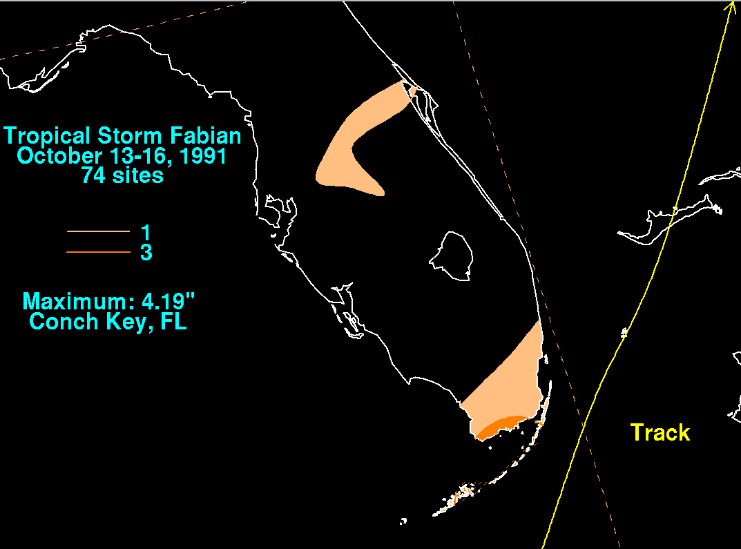
as well as for the Bahamas. The watch in the Bahamas was later upgraded to a warning. Prior to the storm's passage, two state parks were closed in the Florida Keys. In Dade County, Florida, a few storm shelters were opened, in anticipation that Fabian might bring flooding rains. As it passed east of the state, it dropped rainfall near the coast that peaked at 4.19 in (106.4 mm) in Conch Key
. In the Florida Keys, the National Weather Service
Weather Service Office in Key West
recorded sustained winds of 28 mph (44 km/h) with gusts to 32 mph (52 km/h). Only isolated flooding happened from the precursor system to Fabian, and there were no reports of road closings or damage. In South Florida, Homestead Air Force Base reported rainfall of 3.68 inches (93.5 mm), but this too was attributed to the precursor frontal system, rather than Fabian itself.
1991 Atlantic hurricane season
The 1991 Atlantic hurricane season was the first season in over 24 years in which no hurricanes developed from tropical waves, which are the source for most North Atlantic tropical cyclones. The hurricane season officially began on June 1, and ended on November 30. It was the least...
. The sixth named storm of the year, it formed in the northwest Caribbean
Caribbean
The Caribbean is a crescent-shaped group of islands more than 2,000 miles long separating the Gulf of Mexico and the Caribbean Sea, to the west and south, from the Atlantic Ocean, to the east and north...
southwest of Cuba
Cuba
The Republic of Cuba is an island nation in the Caribbean. The nation of Cuba consists of the main island of Cuba, the Isla de la Juventud, and several archipelagos. Havana is the largest city in Cuba and the country's capital. Santiago de Cuba is the second largest city...
. The storm reached a peak intensity of 45 mph (75 km/h), shortly before crossing over Cuba
Cuba
The Republic of Cuba is an island nation in the Caribbean. The nation of Cuba consists of the main island of Cuba, the Isla de la Juventud, and several archipelagos. Havana is the largest city in Cuba and the country's capital. Santiago de Cuba is the second largest city...
as it moved northeast past Florida. Fabian became extratropical north of the Bahamas the next day, and dissipated on October 17. Fabian caused only light rainfall along its path and there were no reported fatalities or damage.
Meteorological history
The origins of Fabian were from a tropical waveTropical wave
Tropical waves, easterly waves, or tropical easterly waves, also known as African easterly waves in the Atlantic region, are a type of atmospheric trough, an elongated area of relatively low air pressure, oriented north to south, which move from east to west across the tropics causing areas of...
and a cold front
Cold front
A cold front is defined as the leading edge of a cooler mass of air, replacing a warmer mass of air.-Development of cold front:The cooler and denser air wedges under the less-dense warmer air, lifting it...
that entered the northwestern Caribbean Sea
Caribbean Sea
The Caribbean Sea is a sea of the Atlantic Ocean located in the tropics of the Western hemisphere. It is bounded by Mexico and Central America to the west and southwest, to the north by the Greater Antilles, and to the east by the Lesser Antilles....
on October 12. The two systems interacted in the Gulf of Honduras
Gulf of Honduras
The Gulf or Bay of Honduras is a large inlet of the Caribbean Sea, indenting the coasts of Belize, Guatemala, and Honduras. From north to south, it runs for approximately 200 km from Dangriga, Belize, to La Ceiba, Honduras....
, producing convection and low atmospheric pressures
Low pressure area
A low-pressure area, or "low", is a region where the atmospheric pressure at sea level is below that of surrounding locations. Low-pressure systems form under areas of wind divergence which occur in upper levels of the troposphere. The formation process of a low-pressure area is known as...
. An anticyclone
Anticyclone
An anticyclone is a weather phenomenon defined by the United States' National Weather Service's glossary as "[a] large-scale circulation of winds around a central region of high atmospheric pressure, clockwise in the Northern Hemisphere, counterclockwise in the Southern Hemisphere"...
developed over the system, which aided in the organization of the thunderstorms. At 1300 UTC
Coordinated Universal Time
Coordinated Universal Time is the primary time standard by which the world regulates clocks and time. It is one of several closely related successors to Greenwich Mean Time. Computer servers, online services and other entities that rely on having a universally accepted time use UTC for that purpose...
on October 15, a Hurricane Hunters
Hurricane Hunters
The Hurricane Hunters are aircraft that fly into tropical cyclones in the North Atlantic Ocean and Northeastern Pacific Ocean for the specific purpose of directly measuring weather data in and around those storms. In the United States, the Air Force, Navy, and NOAA units have all participated in...
flight observed sustained winds of 40 mph (65 km/h) to the southwest of the Isle of Youth
Isle of Youth
Isla de la Juventud is the second-largest Cuban island and the seventh-largest island in the West Indies . The island has an area and is 100 km south of the island of Cuba, across the Gulf of Batabanó...
. Based on the report, the system was classified as Tropical Storm Fabian. Its development
Tropical cyclogenesis
Tropical cyclogenesis is the term that describes the development and strengthening of a tropical cyclone in the atmosphere. The mechanisms through which tropical cyclogenesis occurs are distinctly different from those through which mid-latitude cyclogenesis occurs...
was typical for an October storm in the western Caribbean. With a high pressure area
High pressure area
A high-pressure area is a region where the atmospheric pressure at the surface of the planet is greater than its surrounding environment. Winds within high-pressure areas flow outward due to the higher density air near their center and friction with land...
to the north, there was already a large pressure gradient
Pressure gradient
In atmospheric sciences , the pressure gradient is a physical quantity that describes in which direction and at what rate the pressure changes the most rapidly around a particular location. The pressure gradient is a dimensional quantity expressed in units of pressure per unit length...
that had produced tropical storm force winds over the area. By the time Fabian developed a circulation
Atmospheric circulation
Atmospheric circulation is the large-scale movement of air, and the means by which thermal energy is distributed on the surface of the Earth....
, it was able to be classified as a tropical storm. However, it is possible it was a tropical depression for about 12 hours before the Hurricane Hunters report.
Upon becoming a tropical storm, Fabian was disorganized and had restricted outflow
Outflow (meteorology)
Outflow, in meteorology, is air that flows outwards from a storm system. It is associated with ridging, or anticyclonic flow. In the low levels of the troposphere, outflow radiates from thunderstorms in the form of a wedge of rain-cooled air, which is visible as a thin rope-like cloud on weather...
. An eastward moving upper-level trough
Trough (meteorology)
A trough is an elongated region of relatively low atmospheric pressure, often associated with fronts.Unlike fronts, there is not a universal symbol for a trough on a weather chart. The weather charts in some countries or regions mark troughs by a line. In the United States, a trough may be marked...
imparted a northeast motion as well as unfavorable wind shear
Wind shear
Wind shear, sometimes referred to as windshear or wind gradient, is a difference in wind speed and direction over a relatively short distance in the atmosphere...
. Despite the atmospheric conditions, Fabian intensified slightly to peak winds of 45 mph (75 km/h), although the strongest winds were located primarily east of the center. Late on October 15, the storm moved over the Isle of Youth before crossing over western Cuba. By early on October 16, the center was becoming difficult to locate on satellite imagery. The storm moved through the Florida Straits, passing just southeast of the Florida mainland and into the Bahamas. There was initial uncertainty whether Fabian would be absorbed by the approaching trough or maintain its separate identity. By late on October 16, Fabian transitioned into an extratropical cyclone
Extratropical cyclone
Extratropical cyclones, sometimes called mid-latitude cyclones or wave cyclones, are a group of cyclones defined as synoptic scale low pressure weather systems that occur in the middle latitudes of the Earth having neither tropical nor polar characteristics, and are connected with fronts and...
as it was absorbed into the trough.
Preparations and impact
Tropical cyclone warnings and watches
Warnings and watches are two levels of alert issued by national weather forecasting bodies to coastal areas threatened by the imminent approach of a tropical cyclone of tropical storm or hurricane intensity. They are notices to the local population and civil authorities to make appropriate...
from Havana
La Habana Province
Havana Province was one of the provinces of Cuba, prior to being divided into two new provinces of Artemisa and Mayabeque on January 1, 2011. It had 711,066 people in the 2002 census. The largest city was Artemisa .-Geography:...
to Ciego de Ávila Province
Ciego de Ávila Province
Ciego de Ávila is one of the provinces of Cuba, and was previously part of Camagüey Province. Its capital is Ciego de Ávila, which lies on the Carretera Central , and the second city is Morón, further north....
, as well as the Isle of Youth. Before the storm hit the Cuban mainland, it produced wind gusts to 40 mph (65 km/h) in Cayo Largo del Sur
Cayo Largo del Sur
Cayo Largo del Sur, also known simply as Cayo Largo, cayo largo means largo island, is a small resort island belonging to Cuba, in the Caribbean Sea no more than long and wide...
. Its primary form of impact was from heavy rainfall in a 24 hour period, peaking at 6.2 inches (157.5 mm) in Caonao on the south coast of Cuba
Cuba
The Republic of Cuba is an island nation in the Caribbean. The nation of Cuba consists of the main island of Cuba, the Isla de la Juventud, and several archipelagos. Havana is the largest city in Cuba and the country's capital. Santiago de Cuba is the second largest city...
. In a six hour period, Punta del Este recorded 5 in (127 mm). There were no reports of damage or fatalities.
Concurrent with Fabian's first advisory, a tropical storm watch was issued for all of the Florida Keys
Florida Keys
The Florida Keys are a coral archipelago in southeast United States. They begin at the southeastern tip of the Florida peninsula, about south of Miami, and extend in a gentle arc south-southwest and then westward to Key West, the westernmost of the inhabited islands, and on to the uninhabited Dry...
as well as for the Bahamas. The watch in the Bahamas was later upgraded to a warning. Prior to the storm's passage, two state parks were closed in the Florida Keys. In Dade County, Florida, a few storm shelters were opened, in anticipation that Fabian might bring flooding rains. As it passed east of the state, it dropped rainfall near the coast that peaked at 4.19 in (106.4 mm) in Conch Key
Conch Key, Florida
Conch Key is an island and unincorporated community in Monroe County, Florida, United States. It is located in the middle Florida Keys. U.S. 1 crosses the key at approximately mile markers 62-63, between Long Key and Duck Key...
. In the Florida Keys, the National Weather Service
National Weather Service
The National Weather Service , once known as the Weather Bureau, is one of the six scientific agencies that make up the National Oceanic and Atmospheric Administration of the United States government...
Weather Service Office in Key West
Key West, Florida
Key West is a city in Monroe County, Florida, United States. The city encompasses the island of Key West, the part of Stock Island north of U.S. 1 , Sigsbee Park , Fleming Key , and Sunset Key...
recorded sustained winds of 28 mph (44 km/h) with gusts to 32 mph (52 km/h). Only isolated flooding happened from the precursor system to Fabian, and there were no reports of road closings or damage. In South Florida, Homestead Air Force Base reported rainfall of 3.68 inches (93.5 mm), but this too was attributed to the precursor frontal system, rather than Fabian itself.
See also
- Other storms of the same nameTropical Storm FabianThe name Fabian was used for four tropical cyclones in the Atlantic Ocean and three in the western Pacific.It was used on the modern six-year lists in the Atlantic:...