
Portugal in the Age of Discovery
Encyclopedia
- For additional context, see History of PortugalHistory of PortugalThe history of Portugal, a European and an Atlantic nation, dates back to the Early Middle Ages. In the 15th and 16th centuries, it ascended to the status of a world power during Europe's "Age of Discovery" as it built up a vast empire including possessions in South America, Africa, Asia and...
and Portuguese EmpirePortuguese EmpireThe Portuguese Empire , also known as the Portuguese Overseas Empire or the Portuguese Colonial Empire , was the first global empire in history...
.

India
India , officially the Republic of India , is a country in South Asia. It is the seventh-largest country by geographical area, the second-most populous country with over 1.2 billion people, and the most populous democracy in the world...
that rounded the Cape of Good Hope
Cape of Good Hope
The Cape of Good Hope is a rocky headland on the Atlantic coast of the Cape Peninsula, South Africa.There is a misconception that the Cape of Good Hope is the southern tip of Africa, because it was once believed to be the dividing point between the Atlantic and Indian Oceans. In fact, the...
, discovered Brazil
Brazil
Brazil , officially the Federative Republic of Brazil , is the largest country in South America. It is the world's fifth largest country, both by geographical area and by population with over 192 million people...
, established trading routes throughout most of southern Asia, colonized selected areas of Africa
Africa
Africa is the world's second largest and second most populous continent, after Asia. At about 30.2 million km² including adjacent islands, it covers 6% of the Earth's total surface area and 20.4% of the total land area...
, and sent the first direct European maritime trade and diplomatic missions to China
China
Chinese civilization may refer to:* China for more general discussion of the country.* Chinese culture* Greater China, the transnational community of ethnic Chinese.* History of China* Sinosphere, the area historically affected by Chinese culture...
and Japan
Japan
Japan is an island nation in East Asia. Located in the Pacific Ocean, it lies to the east of the Sea of Japan, China, North Korea, South Korea and Russia, stretching from the Sea of Okhotsk in the north to the East China Sea and Taiwan in the south...
.
Reasons for exploration
Portugal's long shoreline, with its many harbours and rivers flowing westward to the Atlantic oceanAtlantic Ocean
The Atlantic Ocean is the second-largest of the world's oceanic divisions. With a total area of about , it covers approximately 20% of the Earth's surface and about 26% of its water surface area...
was the ideal environment to raise generations of adventurous seamen. As a seafaring people in the south-westernmost region of Europe
Europe
Europe is, by convention, one of the world's seven continents. Comprising the westernmost peninsula of Eurasia, Europe is generally 'divided' from Asia to its east by the watershed divides of the Ural and Caucasus Mountains, the Ural River, the Caspian and Black Seas, and the waterways connecting...
, the Portuguese
Portugal
Portugal , officially the Portuguese Republic is a country situated in southwestern Europe on the Iberian Peninsula. Portugal is the westernmost country of Europe, and is bordered by the Atlantic Ocean to the West and South and by Spain to the North and East. The Atlantic archipelagos of the...
became natural leaders of exploration during the Middle Ages
Middle Ages
The Middle Ages is a periodization of European history from the 5th century to the 15th century. The Middle Ages follows the fall of the Western Roman Empire in 476 and precedes the Early Modern Era. It is the middle period of a three-period division of Western history: Classic, Medieval and Modern...
. Faced with the options of either accessing other European markets by sea (by exploiting its seafaring prowess) or by land (and facing the task of crossing Castile
Crown of Castile
The Crown of Castile was a medieval and modern state in the Iberian Peninsula that formed in 1230 as a result of the third and definitive union of the crowns and parliaments of the kingdoms of Castile and León upon the accession of the then King Ferdinand III of Castile to the vacant Leonese throne...
and Aragon
Aragon
Aragon is a modern autonomous community in Spain, coextensive with the medieval Kingdom of Aragon. Located in northeastern Spain, the Aragonese autonomous community comprises three provinces : Huesca, Zaragoza, and Teruel. Its capital is Zaragoza...
territory) it is not surprising that goods were sent via the sea to England
England
England is a country that is part of the United Kingdom. It shares land borders with Scotland to the north and Wales to the west; the Irish Sea is to the north west, the Celtic Sea to the south west, with the North Sea to the east and the English Channel to the south separating it from continental...
, Flanders
Flanders
Flanders is the community of the Flemings but also one of the institutions in Belgium, and a geographical region located in parts of present-day Belgium, France and the Netherlands. "Flanders" can also refer to the northern part of Belgium that contains Brussels, Bruges, Ghent and Antwerp...
, Italy
Italy
Italy , officially the Italian Republic languages]] under the European Charter for Regional or Minority Languages. In each of these, Italy's official name is as follows:;;;;;;;;), is a unitary parliamentary republic in South-Central Europe. To the north it borders France, Switzerland, Austria and...
and the Hanseatic league
Hanseatic League
The Hanseatic League was an economic alliance of trading cities and their merchant guilds that dominated trade along the coast of Northern Europe...
towns.
Having fought to achieve and to retain independence, the nation's leadership had also a desire for fresh conquests. Added to this was a long struggle to expel the Moors
Moors
The description Moors has referred to several historic and modern populations of the Maghreb region who are predominately of Berber and Arab descent. They came to conquer and rule the Iberian Peninsula for nearly 800 years. At that time they were Muslim, although earlier the people had followed...
that was religiously sanctioned and influenced by foreign crusaders
Crusades
The Crusades were a series of religious wars, blessed by the Pope and the Catholic Church with the main goal of restoring Christian access to the holy places in and near Jerusalem...
with a desire for martial fame. Making war on Islam
Islam
Islam . The most common are and . : Arabic pronunciation varies regionally. The first vowel ranges from ~~. The second vowel ranges from ~~~...
seemed to the Portuguese both their natural destiny and their duty as Christians.
One important reason was the need to overcome the expensive eastern trade routes, dominated first by the republics of Venice and Genoa in the Mediterranean
History of the Mediterranean region
The history of the Mediterranean region is the history of the interaction of the cultures and people of the lands surrounding the Mediterranean Sea —the central superhighway of transport, trade and cultural exchange between diverse peoples...
, and then controlled by the Ottoman Empire after the conquest of Constantinople
Constantinople
Constantinople was the capital of the Roman, Eastern Roman, Byzantine, Latin, and Ottoman Empires. Throughout most of the Middle Ages, Constantinople was Europe's largest and wealthiest city.-Names:...
in 1453, barring European access, and going through North Africa and the historically important combined-land-sea routes via the Red Sea. Both spice and silk were big businesses of the day, and arguably, spices which were used as medicine
Medicine
Medicine is the science and art of healing. It encompasses a variety of health care practices evolved to maintain and restore health by the prevention and treatment of illness....
drug
Drug
A drug, broadly speaking, is any substance that, when absorbed into the body of a living organism, alters normal bodily function. There is no single, precise definition, as there are different meanings in drug control law, government regulations, medicine, and colloquial usage.In pharmacology, a...
s and preservatives was something of a necessity—at least to those Europeans of better than modest means.
The Portuguese economy
Economic history of Portugal
The economic history of Portugal covers the development of the economy throughout the course of Portuguese history. It has its roots prior to nationality, when Roman occupation developed a thriving economy in Hispania, in the provinces of Lusitania and Gallaecia, as producers and exporters to the...
had benefited from its connections with neighbouring Muslim
Muslim
A Muslim, also spelled Moslem, is an adherent of Islam, a monotheistic, Abrahamic religion based on the Quran, which Muslims consider the verbatim word of God as revealed to prophet Muhammad. "Muslim" is the Arabic term for "submitter" .Muslims believe that God is one and incomparable...
states. A money economy was well enough established for 15th century workers in the countryside as well as in the towns to be paid in currency
Currency
In economics, currency refers to a generally accepted medium of exchange. These are usually the coins and banknotes of a particular government, which comprise the physical aspects of a nation's money supply...
. The agriculture of the countryside had diversified to the point where grain was imported from Morocco
Morocco
Morocco , officially the Kingdom of Morocco , is a country located in North Africa. It has a population of more than 32 million and an area of 710,850 km², and also primarily administers the disputed region of the Western Sahara...
(a symptom of an economy dependent upon Portugal's), while specialised crops occupied former grain-growing areas: vineyards, olives, or the sugar factories of the Algarve, later to be reproduced in Brazil
Brazil
Brazil , officially the Federative Republic of Brazil , is the largest country in South America. It is the world's fifth largest country, both by geographical area and by population with over 192 million people...
(Braudel 1985). Most of all, the Aviz
House of Aviz
The House of Aviz is a dynasty of kings of Portugal. In 1385, the Interregnum of the 1383-1385 crisis ended with the acclamation of the Master of the Order of Aviz, John, natural son of king Peter I and Dona Teresa Lourenço as king...
dynasty that had come to power in 1385 marked the semi-eclipse of the conservative land-oriented aristocracy (See The Consolidation of the Monarchy in Portugal.) A constant exchange of cultural ideals made Portugal a centre of knowledge and technological development. Due to these connections with Islamic kingdoms, many mathematician
Mathematician
A mathematician is a person whose primary area of study is the field of mathematics. Mathematicians are concerned with quantity, structure, space, and change....
s and experts in naval technology appeared in Portugal. The Portuguese government impelled this even further by taking full advantage of this and by creating several important research centres in Portugal, where Portuguese and foreign experts made several breakthroughs in the fields of mathematics, cartography and naval technology. Sagres and Lagos
Lagos, Portugal
Lagos is a municipality at the mouth of Bensafrim River and along the Atlantic Ocean, in the Barlavento region of the Algarve, in southern Portugal....
in the Algarve become famous as such places.
Portuguese nautical science
Pedro Nunes
Pedro Nunes , was a Portuguese mathematician, cosmographer, and professor, from a New Christian family. Nunes, considered to be one of the greatest mathematicians of his time , is best known for his contributions in the technical field of navigation, which was crucial to the Portuguese period of...
with studies on how to determine the latitudes by the stars and João de Castro
João de Castro
Dom João de Castro was a Portuguese naval officer and fourth viceroy of Portuguese India. He was called Castro Forte by poet Luís de Camões. Castro was the son of Álvaro de Castro, civil governor of Lisbon...
.
Ships
Until the 15th century, the Portuguese were limited to coastal cabotageCabotage
Cabotage is the transport of goods or passengers between two points in the same country by a vessel or an aircraft registered in another country. Originally starting with shipping, cabotage now also covers aviation, railways and road transport...
navigation using barque
Barque
A barque, barc, or bark is a type of sailing vessel with three or more masts.- History of the term :The word barque appears to have come from the Greek word baris, a term for an Egyptian boat. This entered Latin as barca, which gave rise to the Italian barca, Spanish barco, and the French barge and...
s and barinels (ancient cargo vessels used in the Mediterranean). These boats were small and fragile, with only one mast with a fixed quadrangular sail and did not have the capabilities to overcome the navigational difficulties associated with Southward oceanic exploration, as the strong wind
Wind
Wind is the flow of gases on a large scale. On Earth, wind consists of the bulk movement of air. In outer space, solar wind is the movement of gases or charged particles from the sun through space, while planetary wind is the outgassing of light chemical elements from a planet's atmosphere into space...
s, shoal
Shoal
Shoal, shoals or shoaling may mean:* Shoal, a sandbank or reef creating shallow water, especially where it forms a hazard to shipping* Shoal draught , of a boat with shallow draught which can pass over some shoals: see Draft...
s and strong ocean current
Ocean current
An ocean current is a continuous, directed movement of ocean water generated by the forces acting upon this mean flow, such as breaking waves, wind, Coriolis effect, cabbeling, temperature and salinity differences and tides caused by the gravitational pull of the Moon and the Sun...
s easily overwhelmed their abilities. They are associated with the earliest discoveries, such as the Madeira
Madeira
Madeira is a Portuguese archipelago that lies between and , just under 400 km north of Tenerife, Canary Islands, in the north Atlantic Ocean and an outermost region of the European Union...
Islands, the Azores
Azores
The Archipelago of the Azores is composed of nine volcanic islands situated in the middle of the North Atlantic Ocean, and is located about west from Lisbon and about east from the east coast of North America. The islands, and their economic exclusion zone, form the Autonomous Region of the...
, the Canaries
Canary Islands
The Canary Islands , also known as the Canaries , is a Spanish archipelago located just off the northwest coast of mainland Africa, 100 km west of the border between Morocco and the Western Sahara. The Canaries are a Spanish autonomous community and an outermost region of the European Union...
, and to the early exploration of the north west African coast as far south as Arguim in the current Mauritania
Mauritania
Mauritania is a country in the Maghreb and West Africa. It is bordered by the Atlantic Ocean in the west, by Western Sahara in the north, by Algeria in the northeast, by Mali in the east and southeast, and by Senegal in the southwest...
.
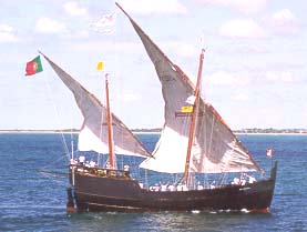
The ship that truly launched the first phase of the Portuguese discoveries along the African coast was the caravel
Caravel
A caravel is a small, highly maneuverable sailing ship developed in the 15th century by the Portuguese to explore along the West African coast and into the Atlantic Ocean. The lateen sails gave her speed and the capacity for sailing to windward...
, a development based on existing fishing boats. They were agile and easier to navigate, with a tonnage of 50 to 160 tons and 1 to 3 masts, with lateen triangular sails allowing luffing
Luffing
In sailing, luffing refers to when a sailing vessel is steered far enough toward the direction of the wind , or the sheet controlling a sail is eased so far past optimal trim, that airflow over the surfaces of the sail is disrupted and the sail begins to "flap" or "luff"...
. The caravel benefited from a greater capacity to tack
Tack (sailing)
Tack is a term used in sailing that has different meanings in different contexts, variously a part of a sail, and an alignment with the wind. When using the latter sense, the maneuver of turning between starboard and port tack is either tacking or jibing....
. The limited capacity for cargo and crew were their main drawbacks, but have not hindered its success. Limited crew and cargo space was acceptable, initially, because as exploratory ships, their "cargo" was what was in the explorer's feedback of a new territory, which only took up the space of one person. Among the famous caravels are Berrio and Caravela Annunciation.
With the start of long oceanic sailing
Sailing
Sailing is the propulsion of a vehicle and the control of its movement with large foils called sails. By changing the rigging, rudder, and sometimes the keel or centre board, a sailor manages the force of the wind on the sails in order to move the boat relative to its surrounding medium and...
also large ships developed. "Nau" was the Portuguese archaic synonym for any large ship, primarily merchant ships. Due to the piracy
Piracy
Piracy is an act of robbery or criminal violence at sea. The term can include acts committed on land, in the air, or in other major bodies of water or on a shore. It does not normally include crimes committed against persons traveling on the same vessel as the perpetrator...
that plagued the coasts, they began to be used in the navy
Navy
A navy is the branch of a nation's armed forces principally designated for naval and amphibious warfare; namely, lake- or ocean-borne combat operations and related functions...
and were provided with canon windows, which led to the classification of "naus" according to the power of its artillery. They were also adapted to the increasing maritime trade: from 200 tons capacity in the 15th century to 500, they become impressive in the 16th century, having usually two deck
Deck (ship)
A deck is a permanent covering over a compartment or a hull of a ship. On a boat or ship, the primary deck is the horizontal structure which forms the 'roof' for the hull, which both strengthens the hull and serves as the primary working surface...
s, stern
Stern
The stern is the rear or aft-most part of a ship or boat, technically defined as the area built up over the sternpost, extending upwards from the counter rail to the taffrail. The stern lies opposite of the bow, the foremost part of a ship. Originally, the term only referred to the aft port section...
castles fore and aft, two to four masts with overlapping sails. In India travels in the sixteenth century there were also used carrack
Carrack
A carrack or nau was a three- or four-masted sailing ship developed in 15th century Western Europe for use in the Atlantic Ocean. It had a high rounded stern with large aftcastle, forecastle and bowsprit at the stem. It was first used by the Portuguese , and later by the Spanish, to explore and...
s, large merchant ships with a high edge and three masts with square sails, that reached 2000 tons.
Celestial navigation
In the thirteenth century celestial navigationCelestial navigation
Celestial navigation, also known as astronavigation, is a position fixing technique that has evolved over several thousand years to help sailors cross oceans without having to rely on estimated calculations, or dead reckoning, to know their position...
was already known, guided by the sun position. For celestial navigation the Portuguese, like other Europeans, used Arab
Arab
Arab people, also known as Arabs , are a panethnicity primarily living in the Arab world, which is located in Western Asia and North Africa. They are identified as such on one or more of genealogical, linguistic, or cultural grounds, with tribal affiliations, and intra-tribal relationships playing...
navigation tools, like the astrolabe
Astrolabe
An astrolabe is an elaborate inclinometer, historically used by astronomers, navigators, and astrologers. Its many uses include locating and predicting the positions of the Sun, Moon, planets, and stars, determining local time given local latitude and longitude, surveying, triangulation, and to...
and quadrant
Quadrant (instrument)
A quadrant is an instrument that is used to measure angles up to 90°. It was originally proposed by Ptolemy as a better kind of astrolabe. Several different variations of the instrument were later produced by medieval Muslim astronomers.-Types of quadrants:...
, which they made easier and simpler. They also created the cross-staff, or cane of Jacob, for measuring at sea the height of the sun and other stars. The Southern Cross become a reference upon arrival at the Southern hemisphere by João de Santarém
João de Santarém
João de Santarém Portuguese explorer that discovered São Tomé and Príncipe together with Pedro Escobar....
and Pedro Escobar
Pedro Escobar
Pedro Escobar, also known as Pêro Escobar, was a 15th century Portuguese navigator who discovered São Tomé and Príncipe together with João de Santarém and Fernão do Pó circa 1470. He is then recorded sailing with Diogo Cão on his first voyage in 1482, and as the pilot of the famous Bérrio caravel...
in 1471, starting the celestial navigation on this constellation. But the results varied throughout the year, which required corrections.
To this the Portuguese used the astronomical tables (Ephemeris
Ephemeris
An ephemeris is a table of values that gives the positions of astronomical objects in the sky at a given time or times. Different kinds of ephemerides are used for astronomy and astrology...
), precious tools for oceanic navigation, which have experienced a remarkable diffusion in the fifteenth century. These tables revolutionized navigation, allowing to calculate latitude
Latitude
In geography, the latitude of a location on the Earth is the angular distance of that location south or north of the Equator. The latitude is an angle, and is usually measured in degrees . The equator has a latitude of 0°, the North pole has a latitude of 90° north , and the South pole has a...
. The tables of the Almanach Perpetuum, by astronomer Abraham Zacuto
Abraham Zacuto
Abraham Zacuto was a Sephardi Jewish astronomer, astrologer, mathematician and historian who served as Royal Astronomer in the 15th century to King John II of Portugal. The crater Zagut on the Moon is named after him....
, published in Leiria in 1496, were used along with its improved astrolabe, by Vasco da Gama
Vasco da Gama
Vasco da Gama, 1st Count of Vidigueira was a Portuguese explorer, one of the most successful in the Age of Discovery and the commander of the first ships to sail directly from Europe to India...
and Pedro Alvares Cabral
Pedro Álvares Cabral
Pedro Álvares Cabral was a Portuguese noble, military commander, navigator and explorer regarded as the discoverer of Brazil. Cabral conducted the first substantial exploration of the northeast coast of South America and claimed it for Portugal. While details of Cabral's early life are sketchy, it...
.
Sailing techniques
Sargasso Sea
The Sargasso Sea is a region in the middle of the North Atlantic Ocean, surrounded by ocean currents. It is bounded on the west by the Gulf Stream; on the north, by the North Atlantic Current; on the east, by the Canary Current; and on the south, by the North Atlantic Equatorial Current. This...
). The knowledge of wind
Wind
Wind is the flow of gases on a large scale. On Earth, wind consists of the bulk movement of air. In outer space, solar wind is the movement of gases or charged particles from the sun through space, while planetary wind is the outgassing of light chemical elements from a planet's atmosphere into space...
patterns and currents
Ocean current
An ocean current is a continuous, directed movement of ocean water generated by the forces acting upon this mean flow, such as breaking waves, wind, Coriolis effect, cabbeling, temperature and salinity differences and tides caused by the gravitational pull of the Moon and the Sun...
, the trade winds and the oceanic gyres in the Atlantic, and the determination of latitude led to the discovery of the best ocean route back from Africa: crossing the Central Atlantic to the latitude of the Azores, using the permanent favorable winds and currents that spin clockwise in the Northern Hemisphere because of atmospheric circulation
Atmospheric circulation
Atmospheric circulation is the large-scale movement of air, and the means by which thermal energy is distributed on the surface of the Earth....
and the effect of Coriolis
Coriolis effect
In physics, the Coriolis effect is a deflection of moving objects when they are viewed in a rotating reference frame. In a reference frame with clockwise rotation, the deflection is to the left of the motion of the object; in one with counter-clockwise rotation, the deflection is to the right...
, facilitating the way to Lisbon and thus enabling the Portuguese venturing increasingly farther from shore, the maneuver that became known as the "volta do mar" (return of the sea). In 1565, the application of this principle in the Pacific Ocean led the Spanish discovering the Manila Galleon
Manila Galleon
The Manila galleons or Manila-Acapulco galleons were Spanish trading ships that sailed once or twice per year across the Pacific Ocean between Manila in the Philippines, and Acapulco, New Spain . The name changed reflecting the city that the ship was sailing from...
trade route.
Cartography
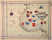
Jehuda Cresques
Jehuda Cresques , also known as Jafudà Cresques, Jaume Riba, and Cresques lo Juheu was a Catalan cartographer, and was once believed to be the man who coordinated the discoveries of the Portuguese naval school at Sagres in the early 15th century.Son of Abraham Cresques, a famous Jewish...
, son of the Catalan cartographer Abraham Cresques have been one of the notable cartographers at the service of Prince Henry. However the oldest signed Portuguese sea chart is a Portolan
Portolan chart
Portolan charts are navigational maps based on realistic descriptions of harbours and coasts. They were first made in the 14th century in Italy, Portugal and Spain...
made by Pedro Reinel
Pedro Reinel
Pedro Reinel was a Portuguese cartographer of the 16th century, author of one of the oldest signed Portuguese nautical chart . That is a portolan type of chart, covering western Europe and part of Africa, and already reflecting the explorations made by Diogo Cão in 1482-1485. With his son Jorge...
in 1485 representing the Western Europe and parts of Africa, reflecting the explorations made by Diogo Cão
Diogo Cão
Diogo Cão was a Portuguese explorer and one of the most remarkable navigators of the Age of Discovery, who made two voyages sailing along the west coast of Africa to Namibia in the 1480s.-Early life and family:...
. Reinel was also author of the first nautical chart known with an indication of latitude
Latitude
In geography, the latitude of a location on the Earth is the angular distance of that location south or north of the Equator. The latitude is an angle, and is usually measured in degrees . The equator has a latitude of 0°, the North pole has a latitude of 90° north , and the South pole has a...
s in 1504 and the first representation of an Wind rose
Wind rose
A wind rose is a graphic tool used by meteorologists to give a succinct view of how wind speed and direction are typically distributed at a particular location. Historically, wind roses were predecessors of the compass rose , as there was no differentiation between a cardinal direction and the wind...
.
With his son, cartographer Jorge Reinel
Jorge Reinel
Jorge Reinel born Lisbon renown Portuguese cartographer and instructor in cartography, son of the well-known cartographer Pedro Reinel. In 1519 in Seville he participated in the maps designed for the trip of his countryman Ferdinand Magellan, and his depiction of the Maluku Islands served as a...
and Lopo Homem
Lopo Homem
Lopo Homem was a Portuguese cartographer and cosmographer.- Biography :In 1517 King Manuel I of Portugal handed Lopo Homem a charter entitling him the privilege of certifying and amending all compass needles in vessels. This charter was revalidated in 1524 by King John III of Portugal...
, they participated in the making of the atlas known as "Lopo Homem-Reinés Atlas" or "Miller Atlas
Miller Atlas
The Miller Atlas also known as Lopo Homem-Reineis Atlas is a Portuguese richly illustrated atlas dated from 1519, including a dozen charts...
", in 1519. They were considered the best cartographers of their time, with Emperor Charles V wanting them to work for him. In 1517 King Manuel I of Portugal
Manuel I of Portugal
Manuel I , the Fortunate , 14th king of Portugal and the Algarves was the son of Infante Ferdinand, Duke of Viseu, , by his wife, Infanta Beatrice of Portugal...
handed Lopo Homem a charter giving him the privilege to certify and amend all compass
Compass
A compass is a navigational instrument that shows directions in a frame of reference that is stationary relative to the surface of the earth. The frame of reference defines the four cardinal directions – north, south, east, and west. Intermediate directions are also defined...
needles in vessels.
In the third phase of the former Portuguese nautical cartography, characterized by the abandonment of the influence of Ptolemy
Ptolemy
Claudius Ptolemy , was a Roman citizen of Egypt who wrote in Greek. He was a mathematician, astronomer, geographer, astrologer, and poet of a single epigram in the Greek Anthology. He lived in Egypt under Roman rule, and is believed to have been born in the town of Ptolemais Hermiou in the...
's representation of the East and more accuracy in the representation of lands and continents, stands out Fernão Vaz Dourado
Fernão Vaz Dourado
Fernão Vaz Dourado was a Portuguese cartographer of the sixteenth century, belonging to the third period of the old Portuguese nautical cartography, which is characterised by the abandonment of Ptolemaic influence in the representation of the Orient and introduction of better accuracy in the...
(Goa ~ 1520 - ~ 1580), whose work has extraordinary quality and beauty, giving him a reputation as one of the best cartographers of the time. Many of his charts are large scale.
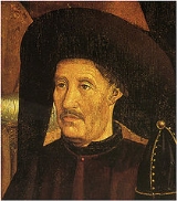
Henry the Navigator
It was the genius of Prince Henry the Navigator that coordinated and utilized all these tendencies towards expansion. Prince Henry placed at the disposal of his captains the vast resources of the Order of ChristOrder of Christ (Portugal)
The Military Order of Christ previously the Royal Order of the Knights of Our Lord Jesus Christ was the heritage of the Knights Templar in Portugal, after the suppression of the Templars in 1312...
, of which he was the head, and the best information and most accurate instruments and maps that could be obtained. He sought to effect a meeting with the half-fabulous Christian Empire of "Prester John
Prester John
The legends of Prester John were popular in Europe from the 12th through the 17th centuries, and told of a Christian patriarch and king said to rule over a Christian nation lost amidst the Muslims and pagans in the Orient. Written accounts of this kingdom are variegated collections of medieval...
" by way of the "Western Nile" (the Sénégal River
Sénégal River
The Sénégal River is a long river in West Africa that forms the border between Senegal and Mauritania.The Sénégal's headwaters are the Semefé and Bafing rivers which both originate in Guinea; they form a small part of the Guinean-Malian border before coming together at Bafoulabé in Mali...
), and, in alliance with that potentate, to crush the Turks
Ottoman Empire
The Ottoman EmpireIt was usually referred to as the "Ottoman Empire", the "Turkish Empire", the "Ottoman Caliphate" or more commonly "Turkey" by its contemporaries...
and liberate the Holy Land
Holy Land
The Holy Land is a term which in Judaism refers to the Kingdom of Israel as defined in the Tanakh. For Jews, the Land's identifiction of being Holy is defined in Judaism by its differentiation from other lands by virtue of the practice of Judaism often possible only in the Land of Israel...
. The concept of an ocean route to India appears to have originated after his death. On land he again defeated the Moors, who attempted to retake Ceuta
Ceuta
Ceuta is an autonomous city of Spain and an exclave located on the north coast of North Africa surrounded by Morocco. Separated from the Iberian peninsula by the Strait of Gibraltar, Ceuta lies on the border of the Mediterranean Sea and the Atlantic Ocean. Ceuta along with the other Spanish...
in 1418; but in an expedition to Tangier
Tangier
Tangier, also Tangiers is a city in northern Morocco with a population of about 700,000 . It lies on the North African coast at the western entrance to the Strait of Gibraltar where the Mediterranean meets the Atlantic Ocean off Cape Spartel...
, undertaken in 1436 by King Edward (1433–1438), the Portuguese army was defeated, and could only escape destruction by surrendering as a hostage Prince Ferdinand
Fernando, the Saint Prince
The Blessed Infante Fernando , commonly known as the Saint Prince was an infante of Portugal of the House of Aviz and a saint of the Roman Catholic Church....
, the king's youngest brother. Ferdinand, known as "the Constant", from the fortitude with which he endured captivity, died unransomed in 1443. By sea Prince Henry's captains continued their exploration of Africa
Africa
Africa is the world's second largest and second most populous continent, after Asia. At about 30.2 million km² including adjacent islands, it covers 6% of the Earth's total surface area and 20.4% of the total land area...
and the Atlantic Ocean
Atlantic Ocean
The Atlantic Ocean is the second-largest of the world's oceanic divisions. With a total area of about , it covers approximately 20% of the Earth's surface and about 26% of its water surface area...
. In 1433 Cape Bojador
Cape Bojador
Cape Bojador or Cape Boujdour is a headland on the northern coast of Western Sahara, at 26° 07' 37"N, 14° 29' 57"W. , as well as the name of a nearby town with a population of 41,178.It is shown on nautical charts with the original Portuguese name "Cabo Bojador", but is sometimes...
was rounded; in 1434 the first consignment of slaves was brought to Lisbon
Lisbon
Lisbon is the capital city and largest city of Portugal with a population of 545,245 within its administrative limits on a land area of . The urban area of Lisbon extends beyond the administrative city limits with a population of 3 million on an area of , making it the 9th most populous urban...
; and slave trading soon became the most profitable branch of Portuguese commerce, until India was reached. The Senegal was reached in 1445, Cape Verde
Cape Verde
The Republic of Cape Verde is an island country, spanning an archipelago of 10 islands located in the central Atlantic Ocean, 570 kilometres off the coast of Western Africa...
was passed in the same year, and in 1446 Álvaro Fernandes
Álvaro Fernandes
Álvaro Fernandes , was a 15th Century Portuguese slave-trader and explorer from Madeira, in the service of Henry the Navigator. He captained two important expeditions , which expanded the limit of the Portuguese discovery of the West African coast, probably as far as the northern borderlands of...
pushed on almost as far as Sierra Leone
Sierra Leone
Sierra Leone , officially the Republic of Sierra Leone, is a country in West Africa. It is bordered by Guinea to the north and east, Liberia to the southeast, and the Atlantic Ocean to the west and southwest. Sierra Leone covers a total area of and has an estimated population between 5.4 and 6.4...
. This was probably the farthest point reached before the Navigator died in 1460. Another vector of the discoveries were the voyages westward, during which the Portuguese discovered the Sargasso Sea
Sargasso Sea
The Sargasso Sea is a region in the middle of the North Atlantic Ocean, surrounded by ocean currents. It is bounded on the west by the Gulf Stream; on the north, by the North Atlantic Current; on the east, by the Canary Current; and on the south, by the North Atlantic Equatorial Current. This...
and possibly sighted the shores of Nova Scotia
Nova Scotia
Nova Scotia is one of Canada's three Maritime provinces and is the most populous province in Atlantic Canada. The name of the province is Latin for "New Scotland," but "Nova Scotia" is the recognized, English-language name of the province. The provincial capital is Halifax. Nova Scotia is the...
well before 1492.
Treaty of Tordesillas
Meanwhile colonization progressed in the AzoresAzores
The Archipelago of the Azores is composed of nine volcanic islands situated in the middle of the North Atlantic Ocean, and is located about west from Lisbon and about east from the east coast of North America. The islands, and their economic exclusion zone, form the Autonomous Region of the...
and Madeira
Madeira
Madeira is a Portuguese archipelago that lies between and , just under 400 km north of Tenerife, Canary Islands, in the north Atlantic Ocean and an outermost region of the European Union...
, where sugar
Sugar
Sugar is a class of edible crystalline carbohydrates, mainly sucrose, lactose, and fructose, characterized by a sweet flavor.Sucrose in its refined form primarily comes from sugar cane and sugar beet...
and wine
Wine
Wine is an alcoholic beverage, made of fermented fruit juice, usually from grapes. The natural chemical balance of grapes lets them ferment without the addition of sugars, acids, enzymes, or other nutrients. Grape wine is produced by fermenting crushed grapes using various types of yeast. Yeast...
were now produced; above all, the gold
Gold
Gold is a chemical element with the symbol Au and an atomic number of 79. Gold is a dense, soft, shiny, malleable and ductile metal. Pure gold has a bright yellow color and luster traditionally considered attractive, which it maintains without oxidizing in air or water. Chemically, gold is a...
brought home from Guinea
Guinea
Guinea , officially the Republic of Guinea , is a country in West Africa. Formerly known as French Guinea , it is today sometimes called Guinea-Conakry to distinguish it from its neighbour Guinea-Bissau. Guinea is divided into eight administrative regions and subdivided into thirty-three prefectures...
stimulated the commercial energy of the Portuguese. It had become clear that, apart from their religious and scientific aspects, these voyages of discovery were highly profitable. Under Afonso V
Afonso V of Portugal
Afonso V KG , called the African , was the twelfth King of Portugal and the Algarves. His sobriquet refers to his conquests in Northern Africa.-Early life:...
(1443–1481), surnamed the African, the Gulf of Guinea
Gulf of Guinea
The Gulf of Guinea is the northeasternmost part of the tropical Atlantic Ocean between Cape Lopez in Gabon, north and west to Cape Palmas in Liberia. The intersection of the Equator and Prime Meridian is in the gulf....
was explored as far as Cape St Catherine (Cabo Santa Caterina),
and three expeditions (1458, 1461 and 1471) were sent to Morocco; in 1471 Arzila (Asila
Asilah
Asilah or Arzila is a fortified town on the northwest tip of the Atlantic coast of Morocco, about 31 km from Tangier. Its ramparts and gateworks remain fully intact...
) and Tangier were captured from the Moors. Under John II
John II of Portugal
John II , the Perfect Prince , was the thirteenth king of Portugal and the Algarves...
(1481–1495) the fortress of São Jorge da Mina
Elmina
Elmina, is a town in the Central Region, situated on a south-facing bay on the Atlantic Ocean coast of Ghana, about 12 km west of Cape Coast...
, the modern Elmina, was founded for the protection of the Guinea trade. Diogo Cão
Diogo Cão
Diogo Cão was a Portuguese explorer and one of the most remarkable navigators of the Age of Discovery, who made two voyages sailing along the west coast of Africa to Namibia in the 1480s.-Early life and family:...
, or Can, discovered the Congo
Congo Basin
The Congo Basin is the sedimentary basin that is the drainage of the Congo River of west equatorial Africa. The basin begins in the highlands of the East African Rift system with input from the Chambeshi River, the Uele and Ubangi Rivers in the upper reaches and the Lualaba River draining wetlands...
in 1482 and reached Cape Cross
Cape Cross
Cape Cross is a cape in the South Atlantic on the coast of Namibia, on the C34 highway some 60 kilometres north of Hentiesbaai and 120 km north of Swakopmund on the west coast of Namibia....
in 1486; Bartolomeu Dias
Bartolomeu Dias
Bartolomeu Dias , a nobleman of the Portuguese royal household, was a Portuguese explorer who sailed around the southernmost tip of Africa in 1488, the first European known to have done so.-Purposes of the Dias expedition:...
doubled the Cape of Good Hope
Cape of Good Hope
The Cape of Good Hope is a rocky headland on the Atlantic coast of the Cape Peninsula, South Africa.There is a misconception that the Cape of Good Hope is the southern tip of Africa, because it was once believed to be the dividing point between the Atlantic and Indian Oceans. In fact, the...
in 1488, thus proving that the Indian Ocean
Indian Ocean
The Indian Ocean is the third largest of the world's oceanic divisions, covering approximately 20% of the water on the Earth's surface. It is bounded on the north by the Indian Subcontinent and Arabian Peninsula ; on the west by eastern Africa; on the east by Indochina, the Sunda Islands, and...
was accessible by sea. After 1492 the discovery of the West Indies by Christopher Columbus
Christopher Columbus
Christopher Columbus was an explorer, colonizer, and navigator, born in the Republic of Genoa, in northwestern Italy. Under the auspices of the Catholic Monarchs of Spain, he completed four voyages across the Atlantic Ocean that led to general European awareness of the American continents in the...
rendered desirable a delimitation
Boundary delimitation
Boundary delimitation, or simply delimitation, is the term used to describe the drawing of boundaries, but is most often used to describe the drawing of electoral boundaries, specifically those of precincts, states, counties or other municipalities...
of the Spanish and Portuguese spheres of exploration. This was accomplished by the Treaty of Tordesillas
Treaty of Tordesillas
The Treaty of Tordesillas , signed at Tordesillas , , divided the newly discovered lands outside Europe between Spain and Portugal along a meridian 370 leagueswest of the Cape Verde islands...
(June 7, 1494) which modified the delimitation authorized by Pope Alexander VI
Pope Alexander VI
Pope Alexander VI , born Roderic Llançol i Borja was Pope from 1492 until his death on 18 August 1503. He is one of the most controversial of the Renaissance popes, and his Italianized surname—Borgia—became a byword for the debased standards of the Papacy of that era, most notoriously the Banquet...
in two bulls
Papal bull
A Papal bull is a particular type of letters patent or charter issued by a Pope of the Catholic Church. It is named after the bulla that was appended to the end in order to authenticate it....
issued on May 4, 1493. The treaty gave to Portugal all lands which might be discovered east of a straight line drawn from the Arctic
Arctic
The Arctic is a region located at the northern-most part of the Earth. The Arctic consists of the Arctic Ocean and parts of Canada, Russia, Greenland, the United States, Norway, Sweden, Finland, and Iceland. The Arctic region consists of a vast, ice-covered ocean, surrounded by treeless permafrost...
Pole to the Antarctic
Antarctic
The Antarctic is the region around the Earth's South Pole, opposite the Arctic region around the North Pole. The Antarctic comprises the continent of Antarctica and the ice shelves, waters and island territories in the Southern Ocean situated south of the Antarctic Convergence...
, at a distance of 370 leagues
League (unit)
A league is a unit of length . It was long common in Europe and Latin America, but it is no longer an official unit in any nation. The league originally referred to the distance a person or a horse could walk in an hour...
west of Cape Verde. Spain received the lands discovered west of this line. As, however, the known means of measuring longitude
Longitude
Longitude is a geographic coordinate that specifies the east-west position of a point on the Earth's surface. It is an angular measurement, usually expressed in degrees, minutes and seconds, and denoted by the Greek letter lambda ....
were so inexact that the line of demarcation could not in practice be determined (see J. de Andrade Corvo in Journal das Ciências Matemáticas, xxxi.147-176, Lisbon, 1881), the treaty was subject to very diverse interpretations. On its provisions were based both the Portuguese claim to Brazil
Brazil
Brazil , officially the Federative Republic of Brazil , is the largest country in South America. It is the world's fifth largest country, both by geographical area and by population with over 192 million people...
and the Spanish claim to the Moluccas (see East Indies#History). The treaty was chiefly valuable to the Portuguese as a recognition of the prestige they had acquired. That prestige was enormously enhanced when, in 1497-1499, Vasco da Gama
Vasco da Gama
Vasco da Gama, 1st Count of Vidigueira was a Portuguese explorer, one of the most successful in the Age of Discovery and the commander of the first ships to sail directly from Europe to India...
completed the voyage to India.
Columbus' discovery of what they thought was India
India
India , officially the Republic of India , is a country in South Asia. It is the seventh-largest country by geographical area, the second-most populous country with over 1.2 billion people, and the most populous democracy in the world...
at that time, is something that historians dispute in terms of the consequences that lead to this discovery. One theory which has some support, due to recent proof that has come to light, is that Columbus was indeed Portuguese as stated initially, but he was a spy from the Portuguese kingdom sent to Spain to redirect Spain's efforts elsewhere than the territories Portugal had its focus on. However, this is controversial. Actions such as this would come as no surprise, though, since competition between the two kingdoms was intense and both had their secret service
Secret service
A secret service describes a government agency, or the activities of a government agency, concerned with the gathering of intelligence data. The tasks and powers of a secret service can vary greatly from one country to another. For instance, a country may establish a secret service which has some...
networks which were in constant conflict with one another, by providing misleading information and in hiding territories and trade routes discovered by each country (but especially Portugal) by either keeping them concealed or by providing false dates and also false locations. This constant secrecy effort was what led to the creation of many "false" documents and thus many of the remaining documents from that time may not be reliable. As a consequence some historians believe that territories such as Brazil, several African locations along its coastline and North America (due to the voyages made westward) may have been discovered before the known dates.
Afonsine Ordinances
While the Crown was thus acquiring new possessions, its authority in Portugal was temporarily overshadowed by the growth of aristocraticAristocracy (class)
The aristocracy are people considered to be in the highest social class in a society which has or once had a political system of Aristocracy. Aristocrats possess hereditary titles granted by a monarch, which once granted them feudal or legal privileges, or deriving, as in Ancient Greece and India,...
privilege. After the death of Edward, further attempts to curb the power of the nobles were made by his brother, D. Pedro, duke of Coimbra
Infante Pedro, Duke of Coimbra
The Infante Peter, 1st Duke of Coimbra KG , was a Portuguese infante of the House of Aviz, son of King John I of Portugal and his wife Philippa of Lancaster, daughter of John of Gaunt. In Portugal he is better known as Infante D. Pedro das Sete Partidas [do Mundo], "of the Seven Parts [of the...
, who acted as regent
Regent
A regent, from the Latin regens "one who reigns", is a person selected to act as head of state because the ruler is a minor, not present, or debilitated. Currently there are only two ruling Regencies in the world, sovereign Liechtenstein and the Malaysian constitutive state of Terengganu...
during the minority of Afonso V of Portugal
Afonso V of Portugal
Afonso V KG , called the African , was the twelfth King of Portugal and the Algarves. His sobriquet refers to his conquests in Northern Africa.-Early life:...
(1438–1447). The head of the aristocratic opposition was the Duke of Braganza
Duke of Braganza
The title Duke of Braganza in the House of Braganza is one of the most important titles in the peerage of Portugal. Since the House of Braganza acceded to the throne of Portugal in 1640, the male heir of the Portuguese Crown was known as the Duke of Braganza and Prince of Brazil until 1822, or...
, who contrived to secure the sympathy of the king and the dismissal of the regent. The quarrel led to civil war, and in May 1449, D. Pedro was defeated and killed. Thenceforward the grants made by John I
John I of Portugal
John I KG , called the Good or of Happy Memory, more rarely and outside Portugal the Bastard, was the tenth King of Portugal and the Algarve and the first to use the title Lord of Ceuta...
were renewed, and extended on so lavish a scale that the Braganza estates alone comprised about a third of the whole kingdom. An unwise foreign policy simultaneously injured the royal prestige, for Afonso married his own niece, Joanna
Joan, Princess of Castile
Joanna of Castile, known also as la Beltraneja was a princess and claimant to the throne of Castile. She was also Queen consort of Portugal.-Birth:...
, daughter of Henry IV of Castile
Henry IV of Castile
Henry IV , King of the Crown of Castile, nicknamed the Impotent , was the last of the weak late medieval kings of Castile...
, and claimed the kingdom in her name. At the Battle of Toro
Battle of Toro
The Battle of Toro was a Royal battle from the War of the Castilian Succession, fought on 1 March 1476, near the city of Toro, between the Castilian troops of the Catholic Monarchs and the Portuguese-Castilian forces of Afonso V and Prince John....
, in 1476, he was defeated by Ferdinand and Isabella, and in 1478 he was compelled to sign the Treaty of Alcantara, by which Joanna was relegated to a convent
Convent
A convent is either a community of priests, religious brothers, religious sisters, or nuns, or the building used by the community, particularly in the Roman Catholic Church and in the Anglican Communion...
. His successor, John II (1481–1495) reverted to the policy of matrimonial alliances with Castile and friendship with England
England
England is a country that is part of the United Kingdom. It shares land borders with Scotland to the north and Wales to the west; the Irish Sea is to the north west, the Celtic Sea to the south west, with the North Sea to the east and the English Channel to the south separating it from continental...
. Finding, as he said, that the liberality of former kings had left the Crown "no estates except the high roads of Portugal," he determined to crush the feudal nobility and seize its territories. A cortes
Parliament
A parliament is a legislature, especially in those countries whose system of government is based on the Westminster system modeled after that of the United Kingdom. The name is derived from the French , the action of parler : a parlement is a discussion. The term came to mean a meeting at which...
held at Évora
Évora
Évora is a municipality in Portugal. It has total area of with a population of 55,619 inhabitants. It is the seat of the Évora District and capital of the Alentejo region. The municipality is composed of 19 civil parishes, and is located in Évora District....
(1481) empowered judges nominated by the Crown to administer justice in all feudal domains. The nobles resisted this infringement of their rights; but their leader, Fernando II, Duke of Braganza
Fernando II, Duke of Braganza
Ferdinand II was the older son of Fernando I, 2nd Duke of Braganza and of his wife, Doña Joana de Castro....
, was beheaded for high treason in 1483; in 1484 the king stabbed to death his own brother-in-law, Diogo, Duke of Viseu
Diogo, Duke of Viseu
Infante Diogo of Viseu was the second son of Infante Fernando, Duke of Viseu, and his wife Beatriz of Portugal.In 1472, when his older brother John, Duke of Viseu, died without issue, Diogo inherited his titles and estates as 4th Duke of Viseu and 3rd Duke of Beja.Diogo was a popular personality...
; and eighty other members of the aristocracy were afterwards executed. Thus John "the Perfect," as he was called, assured the supremacy of the Crown. He was succeeded in 1495 by Emanuel (Manuel) I
Manuel I of Portugal
Manuel I , the Fortunate , 14th king of Portugal and the Algarves was the son of Infante Ferdinand, Duke of Viseu, , by his wife, Infanta Beatrice of Portugal...
, who was named "the Great" or "the Fortunate," because in his reign the sea route to India was discovered and a Portuguese Empire founded.
Portuguese in Asia
The effort to colonize and maintain territories scattered around the entire coast of Africa and its surrounding islands, Brazil, the Indies and Indic territories such as in Malaysia, JapanJapan
Japan is an island nation in East Asia. Located in the Pacific Ocean, it lies to the east of the Sea of Japan, China, North Korea, South Korea and Russia, stretching from the Sea of Okhotsk in the north to the East China Sea and Taiwan in the south...
, China
China
Chinese civilization may refer to:* China for more general discussion of the country.* Chinese culture* Greater China, the transnational community of ethnic Chinese.* History of China* Sinosphere, the area historically affected by Chinese culture...
, Indonesia
Indonesia
Indonesia , officially the Republic of Indonesia , is a country in Southeast Asia and Oceania. Indonesia is an archipelago comprising approximately 13,000 islands. It has 33 provinces with over 238 million people, and is the world's fourth most populous country. Indonesia is a republic, with an...
and Timor
Timor
Timor is an island at the southern end of Maritime Southeast Asia, north of the Timor Sea. It is divided between the independent state of East Timor, and West Timor, belonging to the Indonesian province of East Nusa Tenggara. The island's surface is 30,777 square kilometres...
was a challenge for a population of only one million.
Combined with constant competition from the Spanish
Spain
Spain , officially the Kingdom of Spain languages]] under the European Charter for Regional or Minority Languages. In each of these, Spain's official name is as follows:;;;;;;), is a country and member state of the European Union located in southwestern Europe on the Iberian Peninsula...
this led to a desire for secrecy
Secrecy
Secrecy is the practice of hiding information from certain individuals or groups, perhaps while sharing it with other individuals...
about every trade route and every colony. As a consequence, many documents that could reach other Europe
Europe
Europe is, by convention, one of the world's seven continents. Comprising the westernmost peninsula of Eurasia, Europe is generally 'divided' from Asia to its east by the watershed divides of the Ural and Caucasus Mountains, the Ural River, the Caspian and Black Seas, and the waterways connecting...
an countries were in fact fake documents with fake dates and faked facts, to mislead any other nation's possible efforts.
Archival Material
The tendency to secrecy and falsification of dates casts doubts about the authenticity of many primary sources. Several historians have hypothesized that John II may have known of the existence of BrazilBrazil
Brazil , officially the Federative Republic of Brazil , is the largest country in South America. It is the world's fifth largest country, both by geographical area and by population with over 192 million people...
and North America
North America
North America is a continent wholly within the Northern Hemisphere and almost wholly within the Western Hemisphere. It is also considered a northern subcontinent of the Americas...
as early as 1480 thus explaining his wish in 1494 at the signing of the Treaty of Tordesillas
Treaty of Tordesillas
The Treaty of Tordesillas , signed at Tordesillas , , divided the newly discovered lands outside Europe between Spain and Portugal along a meridian 370 leagueswest of the Cape Verde islands...
, to push the line of influence further west. Many historians suspect that the real documents would have been placed in the Library of Lisbon. Unfortunately, due to the fire following the earthquake of 1755
1755 Lisbon earthquake
The 1755 Lisbon earthquake, also known as the Great Lisbon Earthquake, was a megathrust earthquake that took place on Saturday 1 November 1755, at around 9:40 in the morning. The earthquake was followed by fires and a tsunami, which almost totally destroyed Lisbon in the Kingdom of Portugal, and...
, nearly all of the library's records were destroyed, but an extra copy available in Goa, was transferred to Lisbon Tower of Tombo, during the following 100 years. The Corpo Cronológico (Chronological Corpus), a collection of manuscripts on the Portuguese explorations and discoveries in Africa, Asia and Latin America, was inscribed on UNESCO
UNESCO
The United Nations Educational, Scientific and Cultural Organization is a specialized agency of the United Nations...
’s Memory of the World Register in 2007 in recognition of its historical value "for acquiring knowledge of the political, diplomatic, military, economic and religious history of numerous countries at the time of the Portuguese Discoveries."
Portuguese discoveries and explorations (1415-1543)
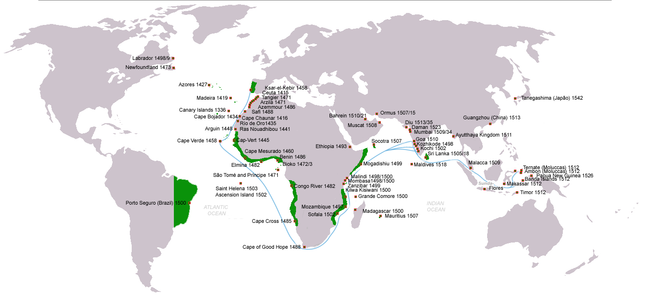
Chronology of the Portuguese discoveries
- 1147—Voyage of the Adventurers. Soon before the siege of LisbonSiege of LisbonThe Siege of Lisbon, from July 1 to October 25, 1147, was the military action that brought the city of Lisbon under definitive Portuguese control and expelled its Moorish overlords. The Siege of Lisbon was one of the few Christian victories of the Second Crusade—it was "the only success of the...
by the crusaders, a Muslim expedition left in search of legendary Islands offshore. They were not heard of again. - 1336—Possible first expedition to the Canary IslandsCanary IslandsThe Canary Islands , also known as the Canaries , is a Spanish archipelago located just off the northwest coast of mainland Africa, 100 km west of the border between Morocco and the Western Sahara. The Canaries are a Spanish autonomous community and an outermost region of the European Union...
with additional expeditions in 1340 and 1341, though this is disputed. - 1412—Prince Henry, the Navigator, orders the first expeditions to the African Coast and Canary Islands.
- 1419—João Gonçalves ZarcoJoão Gonçalves ZarcoJoão Gonçalves Zarco was a Portuguese explorer who established settlements and recognition of the Madeira Islands, and was appointed first captain of Funchal by Henry the Navigator.-Life:...
and Tristão Vaz TeixeiraTristão Vaz TeixeiraTristão Vaz Teixeira was a Portuguese navigator and explorer who, together with João Gonçalves Zarco and Bartolomeu Perestrelo, discovered the Madeira Islands...
discovered Porto Santo islandPorto Santo IslandPorto Santo Island is a Portuguese island northeast of Madeira Island in the North Atlantic Ocean; it is the northernmost and easternmost island of the archipelago of Madeira, located in the Atlantic Ocean west of Europe and Africa.- History :...
, in the Madeira group. - 1420—The same sailors and Bartolomeu PerestreloBartolomeu PerestreloBartolomeu Perestrello , 1st Capitão Donatário, Lord and Governor of the Island of Porto Santo was a Portuguese navigator and explorer that is claimed to have discovered and populated Porto Santo Island together with João Gonçalves Zarco and Tristão Vaz Teixeira...
discovered the island of MadeiraMadeiraMadeira is a Portuguese archipelago that lies between and , just under 400 km north of Tenerife, Canary Islands, in the north Atlantic Ocean and an outermost region of the European Union...
, which at once began to be colonized. - 1422—Cape Nao, the limit of Moorish navigation is passed as the African Coast is mapped.
- 1427—Diogo de SilvesDiogo de SilvesDiogo de Silves, is the presumed name of an obscure Portuguese explorer of the Atlantic who allegedly discovered of the Azores islands in 1427....
discovered the Azores, which was colonized in 1431 by Gonçalo Velho Cabral. - 1434—Gil EanesGil EanesGil Eanes was a 15th-century Portuguese navigator and explorer.Little is known about the personal life of Gil Eanes, prior to his role in the Portuguese Age of Discovery, and was considered a household servant and shield-bearer of the Infante Henry the Navigator...
sailed round Cape Bojador, thus destroying the legends of the ‘Dark Sea’. - 1434—the 32 point compass-card replaces the 12 points used until then.
- 1435—Gil Eanes and Afonso Gonçalves BaldaiaAfonso Gonçalves BaldaiaAfonso Gonçalves Baldaia was a 15th Century Portuguese nautical explorer. He explored much of the coast of Western Sahara in 1435-36 on behalf of the Portuguese prince Henry the Navigator. He would later became one of the first colonists of Terceira Island in the Azores.- Background :Next to...
discovered Garnet Bay (Angra dos Ruivos) and the latter reached the Gold River (Rio de Ouro). - 1441—Nuno TristãoNuno TristãoNuno Tristão was a 15th century Portuguese explorer and slave trader, active in the early 1440s, traditionally thought to be the first European to reach the region of Guinea .-First Voyage:Nuno Tristão was a knight of the household of Henry the Navigator...
reached Cape White. - 1443—Nuno Tristão penetrated the Arguim Gulf. Prince Pedro granted Henry the Navigator the monopoly of navigation, war and trade in the lands south of Cape BojadorCape BojadorCape Bojador or Cape Boujdour is a headland on the northern coast of Western Sahara, at 26° 07' 37"N, 14° 29' 57"W. , as well as the name of a nearby town with a population of 41,178.It is shown on nautical charts with the original Portuguese name "Cabo Bojador", but is sometimes...
. - 1444—Dinis DiasDinis DiasDinis Dias was a 15th century Portuguese explorer.In 1445, as Dias was beginning to enter old age and made the decision to take up exploring because "he was unwilling to let himself grow soft in the well being of repose", left Portugal and sailed down the West African coast, setting a new record by...
reached Cape Green (Cabo Verde). - 1445—Álvaro FernandesÁlvaro FernandesÁlvaro Fernandes , was a 15th Century Portuguese slave-trader and explorer from Madeira, in the service of Henry the Navigator. He captained two important expeditions , which expanded the limit of the Portuguese discovery of the West African coast, probably as far as the northern borderlands of...
sailed beyond Cabo Verde and reached Cabo dos Mastros (Cape Red) - 1446—Alvaro Fernandes reached the northern Part of Portuguese Guinea
- 1452—Diogo de Teive discovers the Islands of Flores and Corvo.
- 1458—Luis Cadamosto discovers the first Cape Verde Islands.
- 1460—Death of Prince Henry, the Navigator. His systematic mapping of the Atlantic,reached 8º N on the African Coast and 40º W in the Atlantic (Sargasso Sea) in his lifetime.
- 1461—Diogo Gomes and António Noli discovered more of the Cape Verde Islands.
- 1461—Diogo Afonso discovered the western islands of the Cabo Verde group.
- 1471—João de SantarémJoão de SantarémJoão de Santarém Portuguese explorer that discovered São Tomé and Príncipe together with Pedro Escobar....
and Pedro EscobarPedro EscobarPedro Escobar, also known as Pêro Escobar, was a 15th century Portuguese navigator who discovered São Tomé and Príncipe together with João de Santarém and Fernão do Pó circa 1470. He is then recorded sailing with Diogo Cão on his first voyage in 1482, and as the pilot of the famous Bérrio caravel...
crossed the Equator. The southern hemisphere was discovered and the sailors began to be guided by a new constellation, the Southern Cross. The discovery of the islands of São Tome and PrincipeSão Tomé and PríncipeSão Tomé and Príncipe, officially the Democratic Republic of São Tomé and Príncipe, is a Portuguese-speaking island nation in the Gulf of Guinea, off the western equatorial coast of Central Africa. It consists of two islands: São Tomé and Príncipe, located about apart and about , respectively, off...
is also attributed to these same sailors. - 1472—João Vaz Corte-Real and Álvaro Martins Homem reached the Land of Cod, now called Newfoundland.
- 1479—Treaty of AlcáçovasTreaty of AlcaçovasThe Treaty of Alcáçovas put an end to the War of the Castilian Succession in favor of Isabella I of Castile, and confirmed Castilian control of the Canary Islands and Portuguese control of the Madeira , Azores and Cape Verde islands , all in the Atlantic Ocean The Treaty of Alcáçovas (also known...
establishes Portuguese control of the Azores, Guinea, ElMina, Madeira and Cape Verde Islands and Castilian control of the Canary Islands. - 1482—Diogo CãoDiogo CãoDiogo Cão was a Portuguese explorer and one of the most remarkable navigators of the Age of Discovery, who made two voyages sailing along the west coast of Africa to Namibia in the 1480s.-Early life and family:...
reached the estuary of the ZaireZaireThe Republic of Zaire was the name of the present Democratic Republic of the Congo between 27 October 1971 and 17 May 1997. The name of Zaire derives from the , itself an adaptation of the Kongo word nzere or nzadi, or "the river that swallows all rivers".-Self-proclaimed Father of the Nation:In...
(Congo) and placed a landmark there. Explored 150 km upriver to the Ielala Falls. - 1484—Diogo Cão reached Walvis BayWalvis BayWalvis Bay , is a city in Namibia and the name of the bay on which it lies...
, south of NamibiaNamibiaNamibia, officially the Republic of Namibia , is a country in southern Africa whose western border is the Atlantic Ocean. It shares land borders with Angola and Zambia to the north, Botswana to the east and South Africa to the south and east. It gained independence from South Africa on 21 March...
. - 1487—Afonso de PaivaAfonso de PaivaAfonso de Paiva was a Portuguese diplomat and explorer of Ethiopia and the Barbary Coast together with Pêro da Covilhã. According to James Bruce, Afonso left Pêro da Covilhã at Aden, and proceeded to Suakin where he hoped to join a caravan to his destination. The further details of his life are...
and Pero da CovilhãPêro da CovilhãPedro or Pêro da Covilhã was a Portuguese diplomat and explorer.He was a native of Covilhã in Beira. In his early life he had gone to Castile and entered the service of Alphonso, Duke of Seville...
traveled overland from Lisbon in search of the Kingdom of Prester JohnPrester JohnThe legends of Prester John were popular in Europe from the 12th through the 17th centuries, and told of a Christian patriarch and king said to rule over a Christian nation lost amidst the Muslims and pagans in the Orient. Written accounts of this kingdom are variegated collections of medieval...
. (EthiopiaEthiopiaEthiopia , officially known as the Federal Democratic Republic of Ethiopia, is a country located in the Horn of Africa. It is the second-most populous nation in Africa, with over 82 million inhabitants, and the tenth-largest by area, occupying 1,100,000 km2...
) - 1488—Bartolomeu DiasBartolomeu DiasBartolomeu Dias , a nobleman of the Portuguese royal household, was a Portuguese explorer who sailed around the southernmost tip of Africa in 1488, the first European known to have done so.-Purposes of the Dias expedition:...
, crowning 50 years of effort and methodical expeditions, rounded the Cape of Good HopeCape of Good HopeThe Cape of Good Hope is a rocky headland on the Atlantic coast of the Cape Peninsula, South Africa.There is a misconception that the Cape of Good Hope is the southern tip of Africa, because it was once believed to be the dividing point between the Atlantic and Indian Oceans. In fact, the...
and entered the Indian OceanIndian OceanThe Indian Ocean is the third largest of the world's oceanic divisions, covering approximately 20% of the water on the Earth's surface. It is bounded on the north by the Indian Subcontinent and Arabian Peninsula ; on the west by eastern Africa; on the east by Indochina, the Sunda Islands, and...
. They had found the "Flat Mountain" of Ptolemy's Geography. - 1489/92—South Atlantic Voyages to map the winds
- 1490—Columbus leaves for Spain after his father-in-law's death.
- 1492—First exploration of the Indian OceanIndian OceanThe Indian Ocean is the third largest of the world's oceanic divisions, covering approximately 20% of the water on the Earth's surface. It is bounded on the north by the Indian Subcontinent and Arabian Peninsula ; on the west by eastern Africa; on the east by Indochina, the Sunda Islands, and...
. - 1494—The Treaty of TordesillasTreaty of TordesillasThe Treaty of Tordesillas , signed at Tordesillas , , divided the newly discovered lands outside Europe between Spain and Portugal along a meridian 370 leagueswest of the Cape Verde islands...
between Portugal and Spain divided the world into two parts, Spain claiming all non-Christian lands west of a north-south line 370 leagues west of the Azores, Portugal claiming all non-Christian lands east of that line. - 1495—Voyage of João FernandesFernandesFernandes is a Portuguese language surname. The name is a patronymic form of the Spanish and Portuguese personal name Fernando.People with the surname "Fernandes" include:*Aaron Fernandes, Canadian field hockey player...
, the Farmer, and Pedro Barcelos to GreenlandGreenlandGreenland is an autonomous country within the Kingdom of Denmark, located between the Arctic and Atlantic Oceans, east of the Canadian Arctic Archipelago. Though physiographically a part of the continent of North America, Greenland has been politically and culturally associated with Europe for...
. During their voyage they discovered the land to which they gave the name of LabradorLabradorLabrador is the distinct, northerly region of the Canadian province of Newfoundland and Labrador. It comprises the mainland portion of the province, separated from the island of Newfoundland by the Strait of Belle Isle...
(lavrador, farmer) - 1494—First boats fitted with cannon doors and topsails.
- 1498—Vasco da GamaVasco da GamaVasco da Gama, 1st Count of Vidigueira was a Portuguese explorer, one of the most successful in the Age of Discovery and the commander of the first ships to sail directly from Europe to India...
led the first fleet around Africa to India, arriving in Calicut. - 1498—Duarte Pacheco PereiraDuarte Pacheco PereiraDuarte Pacheco Pereira, called the Great, was a 15th century Portuguese sea captain, soldier, explorer and cartographer. He travelled particularly in the central Atlantic Ocean west of the Cape Verde islands, along the coast of West Africa and to India...
explores the South Atlantic and the South American Coast North of the Amazon RiverAmazon RiverThe Amazon of South America is the second longest river in the world and by far the largest by waterflow with an average discharge greater than the next seven largest rivers combined...
. - 1500—Pedro Álvares CabralPedro Álvares CabralPedro Álvares Cabral was a Portuguese noble, military commander, navigator and explorer regarded as the discoverer of Brazil. Cabral conducted the first substantial exploration of the northeast coast of South America and claimed it for Portugal. While details of Cabral's early life are sketchy, it...
discovered Brazil on his way to India. - 1500—Gaspar Corte-RealGaspar Corte-RealGaspar Corte-Real was a Portuguese explorer.He was the youngest of three sons of João Vaz Corte-Real, also a Portuguese explorer, and had accompanied his father on his expeditions to North America...
made his first voyage to Newfoundland, formerly known as Terras Corte-Real. - 1500—Diogo DiasDiogo DiasDiogo Dias, also known as Diogo Gomes, was a 15th-century Portuguese explorer. He was the brother of Bartolomeu Dias and discovered some of the Cape Verde islands together with António Noli....
discovered an island they named after St Lawrence after the saint on whose feast day they had first sighted the island later known as MadagascarMadagascarThe Republic of Madagascar is an island country located in the Indian Ocean off the southeastern coast of Africa... - 1502— Returning from India, Vasco da Gama discovers the Amirante Islands (Seychelles).
- 1502—Miguel Corte-RealMiguel Corte-RealMiguel Corte-Real was a Portuguese explorer who charted about 600 miles of the coast of Labrador. In 1501 he disappeared while on an expedition and was believed lost at sea.-Life:...
set out for New England in search of his brother, Gaspar. João da Nova discovered Ascension IslandAscension IslandAscension Island is an isolated volcanic island in the equatorial waters of the South Atlantic Ocean, around from the coast of Africa and from the coast of South America, which is roughly midway between the horn of South America and Africa...
. Fernão de NoronhaFernão de NoronhaFernão de Loronha , whose name is often corrupted to Fernando de Noronha or Fernando della Rogna, was a prominent 16th C. Portuguese merchant of Lisbon, of Jewish descent. He was the first charter-holder , the first donatary captain in Brazil and sponsor of numerous early Portuguese overseas...
discovered the island which still bears his name. - 1503—On his return from the East, Estevão da Gama discovered Saint Helena IslandSaint HelenaSaint Helena , named after St Helena of Constantinople, is an island of volcanic origin in the South Atlantic Ocean. It is part of the British overseas territory of Saint Helena, Ascension and Tristan da Cunha which also includes Ascension Island and the islands of Tristan da Cunha...
. - 1505—Gonçalo ÁlvaresGonçalo ÁlvaresGonçalo Álvares was a Portuguese explorer who actively participated in the age of discovery starting from the second voyage of Diogo Cão....
in the fleet of the first viceroy sailed south in the Atlantic to were "water and even wine froze" discovering an island named after him, modern Gough IslandGough IslandGough Island , also known historically as Gonçalo Álvares or Diego Alvarez, is a volcanic island in the South Atlantic Ocean. It is a dependency of Tristan da Cunha and part of the British overseas territory of Saint Helena, Ascension and Tristan da Cunha... - 1505—Lourenço de AlmeidaLourenço de AlmeidaLourenço de Almeida , son of Francisco de Almeida, acting under him, distinguished himself in the Indian Ocean, and made Ceylon tributary to Portugal...
made the first Portuguese voyage to Ceylon (Sri LankaSri LankaSri Lanka, officially the Democratic Socialist Republic of Sri Lanka is a country off the southern coast of the Indian subcontinent. Known until 1972 as Ceylon , Sri Lanka is an island surrounded by the Indian Ocean, the Gulf of Mannar and the Palk Strait, and lies in the vicinity of India and the...
) and established a settlement there. - 1506—Tristão da Cunha discovered the island that bears his name. Portuguese sailors landed on MadagascarMadagascarThe Republic of Madagascar is an island country located in the Indian Ocean off the southeastern coast of Africa...
. - 1509—The Bay of BengalBay of BengalThe Bay of Bengal , the largest bay in the world, forms the northeastern part of the Indian Ocean. It resembles a triangle in shape, and is bordered mostly by the Eastern Coast of India, southern coast of Bangladesh and Sri Lanka to the west and Burma and the Andaman and Nicobar Islands to the...
crossed by Diogo Lopes de SequeiraDiogo Lopes de SequeiraDiogo Lopes de Sequeira was a Portuguese fidalgo, sent to analyze the trade potential in Madagascar and Malacca, he arrived at Malacca on 11 September, 1509. He left the next year when he discovered that Sultan Mahmud Shah, the local leader, was devising his assassination...
. On the crossing he also reached MalaccaMalaccaMalacca , dubbed The Historic State or Negeri Bersejarah among locals) is the third smallest Malaysian state, after Perlis and Penang. It is located in the southern region of the Malay Peninsula, on the Straits of Malacca. It borders Negeri Sembilan to the north and the state of Johor to the south...
. - 1511—Duarte FernandesDuarte FernandesDuarte Fernandes was a Portuguese diplomat and the first European to establish diplomatic relations with Thailand, when in 1511 he led a diplomatic mission to Ayutthaya Kingdom , after the Portuguese conquest of Malacca....
is the first European to visit the Kingdom of SiamAyutthaya kingdomAyutthaya was a Siamese kingdom that existed from 1350 to 1767. Ayutthaya was friendly towards foreign traders, including the Chinese, Vietnamese , Indians, Japanese and Persians, and later the Portuguese, Spanish, Dutch and French, permitting them to set up villages outside the walls of the...
(Thailand), sent by Afonso de AlbuquerqueAfonso de AlbuquerqueAfonso de Albuquerque[p][n] was a Portuguese fidalgo, or nobleman, an admiral whose military and administrative activities as second governor of Portuguese India conquered and established the Portuguese colonial empire in the Indian Ocean...
after the conquest of Malaca. - 1512— António de AbreuAntónio de AbreuAntónio de Abreu was a 16th century Portuguese navigator and naval officer. He participated under the command of Afonso de Albuquerque in the conquest of Ormus in 1507 and Malacca in 1511, where he got injured...
discovered Timor islandTimorTimor is an island at the southern end of Maritime Southeast Asia, north of the Timor Sea. It is divided between the independent state of East Timor, and West Timor, belonging to the Indonesian province of East Nusa Tenggara. The island's surface is 30,777 square kilometres...
and reached Banda IslandsBanda IslandsThe Banda Islands are a volcanic group of ten small volcanic islands in the Banda Sea, about south of Seram Island and about east of Java, and are part of the Indonesian province of Maluku. The main town and administrative centre is Bandanaira, located on the island of the same name. They rise...
, Ambon IslandAmbon IslandAmbon Island is part of the Maluku Islands of Indonesia. The island has an area of , and is mountainous, well watered, and fertile. Ambon Island consists of 2 territories: The main city and seaport is Ambon , which is also the capital of Maluku province and Maluku Tengah Ambon Island is part of the...
and SeramSeramSeram is an island in the Maluku province of Indonesia. It is located north of Ambon Island. The chief port/town is Masohi.- Geography and geology :...
. Francisco SerrãoFrancisco SerrãoFrancisco Serrão was a Portuguese explorer and a cousin of Ferdinand Magellan. His 1512 voyage was the first known European sailing east past Malacca through Indonesia and the Indies. He became a member of the Sultan Bayan Sirrullah, the ruler of Ternate, becoming his personal advisor...
reached the Moluccas. - 1512—Pedro MascarenhasPedro MascarenhasPedro Mascarenhas was a Portuguese explorer and colonial administrator. He was the first European to discover the island of Diego Garcia in the Indian Ocean in 1512...
discover the island of Diego GarciaDiego GarciaDiego Garcia is a tropical, footprint-shaped coral atoll located south of the equator in the central Indian Ocean at 7 degrees, 26 minutes south latitude. It is part of the British Indian Ocean Territory [BIOT] and is positioned at 72°23' east longitude....
, he also encountered the MauritiusMauritiusMauritius , officially the Republic of Mauritius is an island nation off the southeast coast of the African continent in the southwest Indian Ocean, about east of Madagascar...
, although he may not have been the first to do so; expeditions by Diogo DiasDiogo DiasDiogo Dias, also known as Diogo Gomes, was a 15th-century Portuguese explorer. He was the brother of Bartolomeu Dias and discovered some of the Cape Verde islands together with António Noli....
and Afonso de AlbuquerqueAfonso de AlbuquerqueAfonso de Albuquerque[p][n] was a Portuguese fidalgo, or nobleman, an admiral whose military and administrative activities as second governor of Portuguese India conquered and established the Portuguese colonial empire in the Indian Ocean...
in 1507 may have encountered the islands. In 1528 Diogo RodriguesDiogo RodriguesDiogo Rodrigues was a Portuguese explorer of the Indian Ocean, after whom the island of Rodrigues is named. In 1528 he explored the islands of Réunion, Mauritius, and Rodrigues, naming it the Mascarene or Mascarenhas Islands, after his countryman Pedro Mascarenhas, who had been there...
named the islands of Réunion, Mauritius, and Rodrigues the Mascarene IslandsMascarene IslandsThe Mascarene Islands is a group of islands in the Indian Ocean east of Madagascar comprising Mauritius, Réunion, Rodrigues, Cargados Carajos shoals, plus the former islands of the Saya de Malha, Nazareth and Soudan banks...
, after Mascarenhas. - 1512—João de Lisboa and Estevão Frois reached the La Plata estuary or even perhaps the Gulf of San Matias in 42°S in ArgentinaArgentinaArgentina , officially the Argentine Republic , is the second largest country in South America by land area, after Brazil. It is constituted as a federation of 23 provinces and an autonomous city, Buenos Aires...
between 1511 and 1514 (1512) according to the manuscript Newen Zeytung auss Pressilandt in the Fugger archives of the time. Christopher de HaroChristopher de HaroChristopher de Haro was a Lisbon-based merchant of Flemish origin. He provided the financial backing to Ferdinand Magellan's 1519 voyage, the first circumnavigation around the world....
, the financier of the expedition, bears witness to the trip to La Plata (Rio da Prata) and the news of the "White King" to the interior and west, the Inca emperor - and the axe of silver obtained from the natives and offered to the king Manuel IManuel I of PortugalManuel I , the Fortunate , 14th king of Portugal and the Algarves was the son of Infante Ferdinand, Duke of Viseu, , by his wife, Infanta Beatrice of Portugal...
. - 1513—The first trading ship to touch the coasts of ChinaChinaChinese civilization may refer to:* China for more general discussion of the country.* Chinese culture* Greater China, the transnational community of ethnic Chinese.* History of China* Sinosphere, the area historically affected by Chinese culture...
, under Jorge ÁlvaresJorge ÁlvaresJorge Álvares is credited as the first Portuguese explorer to have reached China and Hong Kong. The Fundação Jorge Álvares , founded by Vasco Joaquim Rocha Vieira prior to the handover of Macau, got its name from him also having reached there.-Exploration:In May 1513 Álvares sailed under the...
and Rafael PerestrelloRafael PerestrelloRafael Perestrello was a Portuguese explorer and a cousin of Filipa Moniz Perestrello, the wife of the famed explorer Christopher Columbus...
later in the same year. - 1517—Fernão Pires de AndradeFernão Pires de AndradeCaptain Fernão Pires de Andrade was a Portuguese merchant, pharmacist, and official diplomat under the explorer and Malacca governor Afonso de Albuquerque...
and Tomé PiresTomé PiresTomé Pires was an apothecary from Lisbon who spent 1512 to 1515 in Malacca immediately after the Portuguese conquest, at a time when Europeans were only first arriving in South East Asia...
were chosen by Manuel I of PortugalManuel I of PortugalManuel I , the Fortunate , 14th king of Portugal and the Algarves was the son of Infante Ferdinand, Duke of Viseu, , by his wife, Infanta Beatrice of Portugal...
to sail to China to formally open relations between the Portuguese Empire and the Ming DynastyMing DynastyThe Ming Dynasty, also Empire of the Great Ming, was the ruling dynasty of China from 1368 to 1644, following the collapse of the Mongol-led Yuan Dynasty. The Ming, "one of the greatest eras of orderly government and social stability in human history", was the last dynasty in China ruled by ethnic...
during the reign of the Zhengde EmperorZhengde EmperorThe Zhengde Emperor was emperor of China between 1505-1521. Born Zhu Houzhao, he was the Hongzhi Emperor's eldest son...
. - 1525—Aleixo Garcia explored the Rio de la Plata in service to Spain, as a member of the expedition of Juan Díaz de SolísJuan Díaz de SolísJuan Díaz de Solís was a Spanish navigator and explorer.Díaz de Solís was probably born in Lebrija, Seville, although some other authors argue that his birth may have actually taken place in Portugal to an Andalusian emigree family....
, and later - from Santa Catarina, BrazilBrazilBrazil , officially the Federative Republic of Brazil , is the largest country in South America. It is the world's fifth largest country, both by geographical area and by population with over 192 million people...
- leading an expedition of some European and 2,000 Guaraní Indians,, explored ParaguayParaguayParaguay , officially the Republic of Paraguay , is a landlocked country in South America. It is bordered by Argentina to the south and southwest, Brazil to the east and northeast, and Bolivia to the northwest. Paraguay lies on both banks of the Paraguay River, which runs through the center of the...
and BoliviaBoliviaBolivia officially known as Plurinational State of Bolivia , is a landlocked country in central South America. It is the poorest country in South America...
. Aleixo García was the first European to cross the ChacoChacoChaco may refer to:in South America:* Chaco Department, a historical department in Paraguay and proposed in Bolivia* Chaco Province, a province in the northeastern part of Argentina* Chaco , a native American tribe in Paraguay...
and even managed to penetrate the outer defenses of the Inca EmpireInca EmpireThe Inca Empire, or Inka Empire , was the largest empire in pre-Columbian America. The administrative, political and military center of the empire was located in Cusco in modern-day Peru. The Inca civilization arose from the highlands of Peru sometime in the early 13th century...
on the hills of the AndesAndesThe Andes is the world's longest continental mountain range. It is a continual range of highlands along the western coast of South America. This range is about long, about to wide , and of an average height of about .Along its length, the Andes is split into several ranges, which are separated...
(near SucreSucreSucre, also known historically as Charcas, La Plata and Chuquisaca is the constitutional capital of Bolivia and the capital of the department of Chuquisaca. Located in the south-central part of the country, Sucre lies at an elevation of 2750m...
), in present-day Bolivia. He was the first European to do so, accomplishing this eight years before Francisco PizarroFrancisco PizarroFrancisco Pizarro González, Marquess was a Spanish conquistador, conqueror of the Incan Empire, and founder of Lima, the modern-day capital of the Republic of Peru.-Early life:...
. - 1526—Discovery of New GuineaNew GuineaNew Guinea is the world's second largest island, after Greenland, covering a land area of 786,000 km2. Located in the southwest Pacific Ocean, it lies geographically to the east of the Malay Archipelago, with which it is sometimes included as part of a greater Indo-Australian Archipelago...
; Jorge de Meneses - 1528—Diogo RodriguesDiogo RodriguesDiogo Rodrigues was a Portuguese explorer of the Indian Ocean, after whom the island of Rodrigues is named. In 1528 he explored the islands of Réunion, Mauritius, and Rodrigues, naming it the Mascarene or Mascarenhas Islands, after his countryman Pedro Mascarenhas, who had been there...
explores the Mascarene islands, that he names after his countryman Pedro MascarenhasPedro MascarenhasPedro Mascarenhas was a Portuguese explorer and colonial administrator. He was the first European to discover the island of Diego Garcia in the Indian Ocean in 1512...
, he explored and named the islands of RéunionRéunionRéunion is a French island with a population of about 800,000 located in the Indian Ocean, east of Madagascar, about south west of Mauritius, the nearest island.Administratively, Réunion is one of the overseas departments of France...
, MauritiusMauritiusMauritius , officially the Republic of Mauritius is an island nation off the southeast coast of the African continent in the southwest Indian Ocean, about east of Madagascar...
, and RodriguesRodrigues (island)Rodrigues , sometimes spelled Rodriguez but named after the Portuguese explorer Diogo Rodrigues, is the smallest of the Mascarene Islands and a dependency of Mauritius... - 1529—Treaty of Saragossa divides the eastern hemisphere between Spain and Portugal, stipulating that the dividing line should lie 297.5 leagues or 17° east of the Moluccas.
- 1542—Fernão Mendes PintoFernão Mendes PintoFernão Mendes Pinto was a Portuguese explorer and writer. His exploits are known through the posthumous publication of his memoir Pilgrimage in 1614, an autobiographical work whose truthfulness is nearly impossible to assess...
, Diogo Zeimoto and Cristovão Borralho reached Japan. - 1542—The coast of CaliforniaCaliforniaCalifornia is a state located on the West Coast of the United States. It is by far the most populous U.S. state, and the third-largest by land area...
explored by João Rodrigues Cabrilho. - 1557—MacauMacauMacau , also spelled Macao , is, along with Hong Kong, one of the two special administrative regions of the People's Republic of China...
(Macao) given to Portugal by the Emperor of ChinaEmperor of ChinaThe Emperor of China refers to any sovereign of Imperial China reigning between the founding of Qin Dynasty of China, united by the King of Qin in 221 BCE, and the fall of Yuan Shikai's Empire of China in 1916. When referred to as the Son of Heaven , a title that predates the Qin unification, the...
as a reward for services rendered against the pirates who infested the China SeaSouth China SeaThe South China Sea is a marginal sea that is part of the Pacific Ocean, encompassing an area from the Singapore and Malacca Straits to the Strait of Taiwan of around...
.
(missing data on Ormuz - from Socotra to Basra, including Muscat, Bahrain, islands in Strait of Hormuz, etc.)
See also

- PortugalPortugalPortugal , officially the Portuguese Republic is a country situated in southwestern Europe on the Iberian Peninsula. Portugal is the westernmost country of Europe, and is bordered by the Atlantic Ocean to the West and South and by Spain to the North and East. The Atlantic archipelagos of the...
- Portuguese peoplePortuguese peopleThe Portuguese are a nation and ethnic group native to the country of Portugal, in the west of the Iberian peninsula of south-west Europe. Their language is Portuguese, and Roman Catholicism is the predominant religion....
- List of Portuguese people
- Naval historyNaval historyNaval history is the area of military history concerning war at sea and the subject is also a sub-discipline of the broad field of maritime history....
- Portuguese EmpirePortuguese EmpireThe Portuguese Empire , also known as the Portuguese Overseas Empire or the Portuguese Colonial Empire , was the first global empire in history...
(1415-1999) - Portuguese colonization of the AmericasPortuguese colonization of the AmericasPortugal was the leading country in the European exploration of the world in the 15th century. The Treaty of Tordesillas divided the Earth, outside Europe, in 1494 into Spanish and Portuguese global territorial hemispheres for exclusive conquest and colonization...
- LusitaniaLusitaniaLusitania or Hispania Lusitania was an ancient Roman province including approximately all of modern Portugal south of the Douro river and part of modern Spain . It was named after the Lusitani or Lusitanian people...