

Sénégal River
Encyclopedia
The Sénégal River is a 1790 km (1,112.3 mi) long river
in West Africa
that forms the border between Senegal
and Mauritania
.
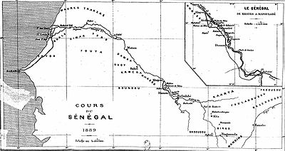
The Sénégal's headwaters are the Semefé (Bakoye) and Bafing
rivers which both originate in Guinea
; they form a small part of the Guinean-Mali
an border before coming together at Bafoulabé
in Mali. From there, the Senegal river flows west and then north through the spectacular Talari Gorges
near Galougo and over the Gouina Falls
, then flows more gently past Kayes
, where it receives the Kolinbine. After flowing together with the Karakoro
, it prolongs the former's course along the Mali-Mauritanian border for some tens of kilometers till Bakel
where it flows together with the Faleme river
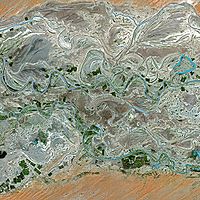
, which also has its source in Guinea, subsequently runs along a small part of the Guinea-Mali frontier to then trace most of the Senegal-Mali border up to Bakel. The Senegal further flows through semi-arid land in the north of Senegal, forming the border with Mauritania and into the Atlantic
. In Kaedi
it accepts the Gorgol
from Mauritania. Flowing through Bogue
it reaches Richard Toll
where it is joined by the Ferlo
coming from inland Senegal's Lac de Guiers
. It passes through Rosso
and, approaching its mouth, around the Senegalese island on which the city of Saint-Louis
is located, to then turn south. It is separated from the Atlantic Ocean by a thin strip of sand called the Langue de Barbarie
before it pours into the ocean itself.
The river has two large dam
s along its course, the Manantali Dam
in Mali, built as a reservoir
, and the Maka-Diama dam on the Mauritania-Senegal border, near the outlet to the sea, preventing access of salt water
upstream
.
The Senegal River has a drainage basin
of 483181 km² (186,557.2 sq mi), a mean flow of 640 m3/s at its mouth, and an estimated annual discharge of 20,000 cubic hectometers. Important tributaries
are the Faleme River
, Karakoro River
, and the Gorgol River
.
In 1972 Mali, Mauritania and Senegal founded the Organisation pour la mise en valeur du fleuve Sénégal
(OMVS) to manage the river basin. Guinea
joined in 2005.
 The aquatic fauna in the Sénégal River basin is closely associated with that of the Gambia River
basin, and the two are usually combined under a single ecoregion
known as the Senegal-Gambia Catchments. Although the species richness
is moderately high, only three species of frogs and one fish are endemic to this ecoregion.
(from Phoenician "behemoth
" for hippopotamus
) and Nias by Claudius Ptolemy. It was visited by Hanno the Carthaginian
around 450 BCE at his navigation from Carthage
through the pillars of Herakles to Theon Ochema (Mount Cameroon
) in the Gulf of Guinea
. There was trade from here to the Mediterranean World, until the destruction of Carthage and its west Africa
n trade net in 146 BCE.
In the Early Middle Ages (c.800 CE), the Senegal River restored contact with the Mediterranean world with the establishment of the Trans-Saharan trade
route between Morocco
and the Ghana Empire
. Arab geographers, like al-Bakri of Spain (1068) and al-Idrisi of Sicily (1154), provided some of the earliest descriptions of the Senegal River. Many believed the upper Senegal River and the upper Niger River
were connected to each other, and formed a single river flowing from east to west, which they called the "Western Nile" or the "Nile of the Blacks". It was believed to be either a western branch of the Egyptian Nile River or drawn from the same source (variously conjectured to be Ptolemy
's Ghir or the Biblical Gihon
stream or some great internal African lake).
Arab geographers Abd al-Hassan Ali ibn Omar (1230), Ibn Said al-Maghribi (1274) and Abulfeda
(1331), label the Senegal as the "Nile of Ghana
" (Nil Gana or Nili Ganah).
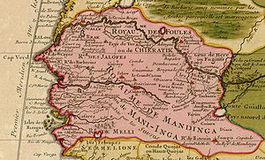
As the Senegal River reached into the heart of the gold-producing Ghana Empire
and later the Mali Empire
, Trans-Saharan traders gave the Senegal its famous nickname as the "River of Gold". The Trans-Saharan stories about the "River of Gold" reached the ears of Mediterranean merchants that frequented the ports of Morocco and the lure proved irresistible. Al-Idrisi reports that at least three separate Arab maritime expeditions - the last one organized by a group of Muslim merchants of Lisbon
(before 1147) - tried to sail down the West African coast in an effort find the mouth of the Senegal River and reach the gold source directly. Their fate is unknown.
Early European portolan maps of the 14th C. (e.g. 1367 map of Domenico and Francesco Pizzigano and the 1375 Catalan Atlas
) drew on Arab sources sources and depicted the "River of Gold" (if only fantastically), draining into the Atlantic Ocean somewhere just south of Cape Bojador
. The legend of Cape Bojador as a terrifying obstacle, the 'cape of no return' to sailors, emerged around the same time (possibly encouraged by Trans-Saharan traders who did not want to see their land route side-stepped by sea).
Christian Europeans soon began attempting to find the sea route to the Senegal. The first known effort is by the Genoese
brothers Vandino and Ugolino Vivaldi
, who set out down down the coast in 1291 in a pair of ships (nothing more is heard of them). In 1346, the Majorcan sailor, Jaume Ferrer
set out on a galley, with the explicit objective of finding the "River of Gold" (Riu de l'Or), where he heard that most people along its shores were engaged in the collection of gold and that the river was wide and deep enough for the largest ships. Nothing more is heard of him either. In 1402, after establishing the first European colony on the Canary Islands
, the French Norman adventurers Jean de Béthencourt
and Gadifer de la Salle
set about immediately probing the African coast, looking for directions to the mouth of Senegal.
The project of finding the Senegal was taken up in the 1420s by the Portuguese
Prince Henry the Navigator, who invested heavily to reach it. In 1434, one of Henry's captains, Gil Eanes
, finally surpassed Cape Bojador and returned to tell about it. Henry immediately dispatched a follow up mission in 1435, under Gil Eanes and Afonso Gonçalves Baldaia
. Going down the coast, they turned around the al-Dakhla
peninsula and emerged into an inlet, which they excitedly believed to be the mouth of the Senegal River. They mistakenly bestowed the name "Rio do Ouro" on that Western Sahara
n inlet, a name it would remain stuck with
down to the 20th C.
Realizing the mistake, Henry kept pressing his captains further down the coast, and in 1445, the Portuguese captain Nuno Tristão
finally reached the Langue de Barbarie
, where he noticed the desert end and the treeline begin, and the population change from 'tawny' Sanhaja
Berbers to 'black' Wolof people
. Bad weather or lack of supplies prevented Tristão from actually reaching the mouth of the Senegal River, but he rushed back to Portugal to report he had finally found the "Land of the Blacks" (Terra dos Negros), and that the "Nile" was surely nearby. Shortly after (possibly still within that same year) another captain, Dinis Dias
(sometimes given as Dinis Fernandes) was the first known European since antiquity to finally reach the mouth of the Senegal River. However, Dias did not sail upriver, but instead kept sailing down the Grande Côte to the bay of Dakar
.
The very next year, in 1446, the Portuguese slave-raiding fleet of Lançarote de Freitas
arrived at the mouth of the Senegal. One of its captains, Estêvão Afonso, volunteered to take a launch
to explore upriver for settlements, thus becoming the first European to actually enter the Senegal river. He didn't get very far. Venturing ashore at one point along the river bank, Afonso tried to kidnap two Wolof children from a woodsman's hut. But he ran into their father, who proceeded to chase the Portuguese back to their launch and gave them such a beating that the explorers gave up on going any further, and turned back to the waiting caravels.
Sometime between 1448 and 1455, the Portuguese captain Lourenço Dias opened regular trade contact on the Senegal River, with the Wolof
statelets of Waalo
(near the mouth of the Senegal River) and Cayor
(a little below that), drumming up a profitable business exchanging Mediterranean goods (notably, horses) for gold and slaves. Chronicler Gomes Eanes de Zurara, writing in 1453, still called it the "Nile River", but Alvise Cadamosto, writing in the 1460s, was already calling it the "Senega" [sic], and it is denoted as Rio do Çanagà on most subsequent Portuguese maps of the age. Cadamosto relates the legend that both the Senegal and the Egyptian Nile were branches of the Biblical Gihon
River that stems from the Garden of Eden
and flows through Ethiopia
. He also notes that the Senegal was called "the Niger" by the ancients - probably a reference to Ptolemy
's legendary 'Nigir' (below the Gir), which would be later identified by Leo Africanus
with the modern Niger River
. Much the same story is repeated by Marmol in 1573, with the additional note that both the Senegal River and Gambia River
were tributaries of the Niger River
. However, the contemporary African atlas of Venetian cartographer Livio Sanuto, published in 1588, sketches the Senegal, the Niger and the Gambia as three separate, parallel rivers.
 Portuguese chronicler João de Barros
(writing in 1552) says the river's original local Wolof
name was Ovedech (which according to one source, comes from "vi-dekh", Wolof for "this river"). His contemporary, Damião de Góis
(1567) records it as Sonedech (from "sunu dekh", Wolof for "our river"). Writing in 1573, the Spanish geographer Luis del Marmol Carvajal asserts that the Portuguese
called it Zenega, the 'Zeneges' (Berber Zenaga
) called it the Zenedec, the 'Gelofes' (Wolofs
) call it Dengueh, the 'Tucorones' (Fula Toucouleur) called it Mayo, the 'Çaragoles' (Soninke Sarakole of Ngalam) called it Colle and further along (again, Marmol assuming Senegal was connected to the Niger), the people of Bagamo' (Bambara of Bamako
?) called it Zimbala (Jimbala?) and the people of Timbuktu
called it the Yça.
asserts the Portuguese renamed it "Senegal" because that was the personal name of a local Wolof chieftain who frequently conducted business with the Portuguese traders. But this etymology is doubtful (e.g. the ruler of Senegalese river state of Waalo
bears the title 'Brak
', and Cadamosto gives the personal name of the Senegal river chieftan as "Zucholin"). The confusion may have arisen because Cadamosto says the Portuguese interacted frequently with a certain Wolof chieftain south of the river, somewhere on the Grande Côte, which he refers to as Budomel. "Budomel" is almost certainly a reference to the ruler of Cayor
, a combination of his formal title ("Damel
"), prefixed by the generic Wolof
term bor ("lord"). Curiously, Budomel is reminiscent of Vedamel already used by the Genoese back in the 14th C. as an alternative name of the Senegal River. It is almost certain that the Genoese "Vedamel" are corruptions from the Arabic, either Wad al-mal ("River of Treasure", i.e. Gold) or, alternatively, Wad al-Melli ("River of Mali") or even, by transcription error, Wad al-Nill ("River of Nile").
 Other etymological theories for "Senegal" abound. A popular one, first proposed by Fr. David Boilat (1853), was that "Senegal" comes from the Wolof
phrase sunu gaal, meaning "our canoe" (more precisely, "our pirogue
"). Bailot speculates the name probably arose as a misunderstanding, that when a Portuguese captain came across some Wolof fishermen and asked them what the name of the river was, they believed he was asking who their fishing boat belonged to, and replied simply "it is our canoe" (sunu gaal). The "our canoe" theory has been popularly embraced in modern Senegal
for its charm and appeal to national solidarity ("we're all in one canoe", etc.).
More recent historians suggest the name "Senegal" is probably a derivation of Azenegue, the Portuguese term for the Saharan Berber Zenaga people
that lived north of it.
A strong challenge to this theory is that "Senegal" is much older, and might derive from "Sanghana" (also given as Isenghan, Asengan, Singhanah), a city described by the Arab historian al-Bakri in 1068 as located by the mouth of the Senegal River (straddling both banks) and the capital of a local kingdom. The location Senegany is depicted in 1351 Genoese map known as the Medici Atlas
(Laurentian Gaddiano portolan). This town ("Isingan") is fantastically depicted in the 1413 portolan map of Majorcan cartographer Mecia de Viladestes. The name itself might be of Berber Zenaga
origin, speculatively related to 'Ismegh' ('black slave', analogous to the Arabic 'abd
) or 'sagui nughal' ('border'). Some sources claim 'Isinghan' remained the usual Berber term to refer to the Wolof kingdom of Cayor
.
Some Serer people
from the south have advanced the claim that the river's name is originally derived from the compound of the Serer term "Sene" (from Roge Sene, Supreme Deity in Serer religion
) and "O Gal" (meaning "body of water").
River
A river is a natural watercourse, usually freshwater, flowing towards an ocean, a lake, a sea, or another river. In a few cases, a river simply flows into the ground or dries up completely before reaching another body of water. Small rivers may also be called by several other names, including...
in West Africa
West Africa
West Africa or Western Africa is the westernmost region of the African continent. Geopolitically, the UN definition of Western Africa includes the following 16 countries and an area of approximately 5 million square km:-Flags of West Africa:...
that forms the border between Senegal
Senegal
Senegal , officially the Republic of Senegal , is a country in western Africa. It owes its name to the Sénégal River that borders it to the east and north...
and Mauritania
Mauritania
Mauritania is a country in the Maghreb and West Africa. It is bordered by the Atlantic Ocean in the west, by Western Sahara in the north, by Algeria in the northeast, by Mali in the east and southeast, and by Senegal in the southwest...
.
The Sénégal's headwaters are the Semefé (Bakoye) and Bafing
Bafing River
The Bafing River runs through Guinea and Mali and is about long. It joins with the Bakoy River in Bafoulabé to form the Sénégal River, in the Kayes Region of western Mali. It is also called the Black River while the Bakoy is called the White River...
rivers which both originate in Guinea
Guinea
Guinea , officially the Republic of Guinea , is a country in West Africa. Formerly known as French Guinea , it is today sometimes called Guinea-Conakry to distinguish it from its neighbour Guinea-Bissau. Guinea is divided into eight administrative regions and subdivided into thirty-three prefectures...
; they form a small part of the Guinean-Mali
Mali
Mali , officially the Republic of Mali , is a landlocked country in Western Africa. Mali borders Algeria on the north, Niger on the east, Burkina Faso and the Côte d'Ivoire on the south, Guinea on the south-west, and Senegal and Mauritania on the west. Its size is just over 1,240,000 km² with...
an border before coming together at Bafoulabé
Bafoulabé
Bafoulabé is a town and commune in south-western Mali. It is located in the Region of Kayes. Bafoulabé is the capital of the Cercle of Bafoulabé, which in 1887 was the first Cercle to be created in Mali.-Local administration:...
in Mali. From there, the Senegal river flows west and then north through the spectacular Talari Gorges
Talari Gorges
The Talari Gorges or Gorges de Talary are a series of gorges on the Sénégal River in Mali, between the towns of Bafoulabé and Galougo in the Kayes Region, at an altitude of about 75 meters or 249 feet above sea level. They are celebrated for their grandiose beauty. Downstream, to the...
near Galougo and over the Gouina Falls
Gouina Falls
The Gouina Falls or Chutes de Gouina are on the Sénégal River in Mali between the towns of Bafoulabé and Diamou in the Kayes Region, where the river runs north from the Talari Gorges. They have been called the "Niagara falls of Mali". The river is about 500 m wide at this point, and drops...
, then flows more gently past Kayes
Kayes
Kayes is a city in western Mali on the Sénégal River, with a population of roughly 100,000 people. Kayes is the capital of the administrative region of the same name. The name "Kayes" comes from the Soninké word "karré", which describes a low humid place that floods in rainy season...
, where it receives the Kolinbine. After flowing together with the Karakoro
Karakoro
Karakoro may refer to:*Karakoro River*Karakoro, Côte d'Ivoire*Karakoro, Mali...
, it prolongs the former's course along the Mali-Mauritanian border for some tens of kilometers till Bakel
Bakel
Bakel is a village east of Helmond and Eindhoven in southern part of the Netherlands. The total population is approximately 5,000. Until the late 1990s it formed together with Milheeze and Rips the municipality of Bakel and Milheeze but in 1997 it was forced to merge with the larger Gemert...
where it flows together with the Faleme river
Faleme River
The Falémé River is a river in West Africa. The Falémé arises in northern Guinea and flows in a north-northeast direction to Mali, forming a short portion of the border between Guinea and Senegal...
, which also has its source in Guinea, subsequently runs along a small part of the Guinea-Mali frontier to then trace most of the Senegal-Mali border up to Bakel. The Senegal further flows through semi-arid land in the north of Senegal, forming the border with Mauritania and into the Atlantic
Atlantic Ocean
The Atlantic Ocean is the second-largest of the world's oceanic divisions. With a total area of about , it covers approximately 20% of the Earth's surface and about 26% of its water surface area...
. In Kaedi
Kaédi
Kaédi is a city of over 60,000 people and is the largest city and administrative center of the Gorgol region of Southern Mauritania. The city is located 16.150 degrees latitude and -13.500 degrees longitude, and is approximately 435 km from Mauritania's capital, Nouakchott.- Overview :The...
it accepts the Gorgol
Gorgol
Gorgol is a region in southern Mauritania. Its capital is Kaédi and the Gorgol River forms parts of the landscape. Other major cities/towns include Mbout and Maghama...
from Mauritania. Flowing through Bogue
Bogue
Bogue may refer to:Places* Bogue, Dumfries and Galloway in Scotland* Bogue, Kansas, United States* Bogué, Mauritania* Bogue, North Carolina, United States* Bocca Tigris or the Bogue, a narrow strait in the Pearl River outside Guangzhou, ChinaPeople...
it reaches Richard Toll
Richard Toll
Richard Toll is a town in northern Senegal, lying on the south bank of the River Senegal, just east of Rosso. Originally a colonial town, it was name for the park of the Chateau de Baron Roger, laid out by botanist Jean Michel Claude Richard. A rice growing scheme was originally initiated by...
where it is joined by the Ferlo
Ferlo
Ferlo is a region in Senegal's Ferio Desert, rapidly depopulated because of desertification. There are two Faunal Reserves in Ferlo....
coming from inland Senegal's Lac de Guiers
Lac de Guiers
The Lac de Guiers or Lake Guiers is a lake in northern Senegal, south of the city of Richard-Toll and in the Louga and Saint-Louis regions...
. It passes through Rosso
Rosso
Rosso is the major city of south-western Mauritania and capital of Trarza region. It is situated on the Senegal River at the head of year-round navigation. The town is 204 km south of the capital Nouakchott...
and, approaching its mouth, around the Senegalese island on which the city of Saint-Louis
Saint-Louis, Senegal
Saint-Louis, or Ndar as it is called in Wolof, is the capital of Senegal's Saint-Louis Region. Located in the northwest of Senegal, near the mouth of the Senegal River, and 320 km north of Senegal's capital city Dakar, it has a population officially estimated at 176,000 in 2005. Saint-Louis...
is located, to then turn south. It is separated from the Atlantic Ocean by a thin strip of sand called the Langue de Barbarie
Langue de Barbarie
The Langue de Barbarie is a thin, sandy peninsula, adjacent to the Atlantic Ocean, located in western Senegal, in the neighbourhood of the city of Saint-Louis.. The peninsula separates the ocean from the final section of the Senegal River...
before it pours into the ocean itself.
The river has two large dam
Dam
A dam is a barrier that impounds water or underground streams. Dams generally serve the primary purpose of retaining water, while other structures such as floodgates or levees are used to manage or prevent water flow into specific land regions. Hydropower and pumped-storage hydroelectricity are...
s along its course, the Manantali Dam
Manantali Dam
The Manantali Dam is a multi-purpose dam on the Bafing river in the Senegal River basin, 90 km to the south-east of Bafoulabé, in Mali's Kayes Region.-History:...
in Mali, built as a reservoir
Reservoir
A reservoir , artificial lake or dam is used to store water.Reservoirs may be created in river valleys by the construction of a dam or may be built by excavation in the ground or by conventional construction techniques such as brickwork or cast concrete.The term reservoir may also be used to...
, and the Maka-Diama dam on the Mauritania-Senegal border, near the outlet to the sea, preventing access of salt water
Seawater
Seawater is water from a sea or ocean. On average, seawater in the world's oceans has a salinity of about 3.5% . This means that every kilogram of seawater has approximately of dissolved salts . The average density of seawater at the ocean surface is 1.025 g/ml...
upstream
Source (river or stream)
The source or headwaters of a river or stream is the place from which the water in the river or stream originates.-Definition:There is no universally agreed upon definition for determining a stream's source...
.
The Senegal River has a drainage basin
Drainage basin
A drainage basin is an extent or an area of land where surface water from rain and melting snow or ice converges to a single point, usually the exit of the basin, where the waters join another waterbody, such as a river, lake, reservoir, estuary, wetland, sea, or ocean...
of 483181 km² (186,557.2 sq mi), a mean flow of 640 m3/s at its mouth, and an estimated annual discharge of 20,000 cubic hectometers. Important tributaries
Tributary
A tributary or affluent is a stream or river that flows into a main stem river or a lake. A tributary does not flow directly into a sea or ocean...
are the Faleme River
Faleme River
The Falémé River is a river in West Africa. The Falémé arises in northern Guinea and flows in a north-northeast direction to Mali, forming a short portion of the border between Guinea and Senegal...
, Karakoro River
Karakoro River
The Karakoro River is an important tributary to the Senegal River, and forms part of the Mauritania-Mali border....
, and the Gorgol River
Gorgol River
The Gorgol River is a river of southern Mauritania. Located in the south flowing through the Gorgol valley, it is a tributary of the Senegal River.The river basin plays an important in role in Mauritanian economy facilated by investment in the 1970s...
.
In 1972 Mali, Mauritania and Senegal founded the Organisation pour la mise en valeur du fleuve Sénégal
Organisation pour la mise en valeur du fleuve Sénégal
The Organisation pour la mise en valeur du fleuve Sénégal is an organisation of Guinea, Mali, Mauritania and Senegal to manage the Senegal River and its drainage basin....
(OMVS) to manage the river basin. Guinea
Guinea
Guinea , officially the Republic of Guinea , is a country in West Africa. Formerly known as French Guinea , it is today sometimes called Guinea-Conakry to distinguish it from its neighbour Guinea-Bissau. Guinea is divided into eight administrative regions and subdivided into thirty-three prefectures...
joined in 2005.
Gambia River
The Gambia River is a major river in West Africa, running from the Fouta Djallon plateau in north Guinea westward through Senegal and The Gambia to the Atlantic Ocean at the city of Banjul...
basin, and the two are usually combined under a single ecoregion
Ecoregion
An ecoregion , sometimes called a bioregion, is an ecologically and geographically defined area that is smaller than an ecozone and larger than an ecosystem. Ecoregions cover relatively large areas of land or water, and contain characteristic, geographically distinct assemblages of natural...
known as the Senegal-Gambia Catchments. Although the species richness
Species richness
Species richness is the number of different species in a given area. It is represented in equation form as S.Species richness is the fundamental unit in which to assess the homogeneity of an environment. Typically, species richness is used in conservation studies to determine the sensitivity of...
is moderately high, only three species of frogs and one fish are endemic to this ecoregion.
History
The existence of the Senegal River was known to the early Mediterranean civilizations. It was called Bambotus by Pliny the ElderPliny the Elder
Gaius Plinius Secundus , better known as Pliny the Elder, was a Roman author, naturalist, and natural philosopher, as well as naval and army commander of the early Roman Empire, and personal friend of the emperor Vespasian...
(from Phoenician "behemoth
Behemoth
Behemoth is a mythological beast mentioned in the Book of Job, 40:15-24. Metaphorically, the name has come to be used for any extremely large or powerful entity.-Plural as singular:...
" for hippopotamus
Hippopotamus
The hippopotamus , or hippo, from the ancient Greek for "river horse" , is a large, mostly herbivorous mammal in sub-Saharan Africa, and one of only two extant species in the family Hippopotamidae After the elephant and rhinoceros, the hippopotamus is the third largest land mammal and the heaviest...
) and Nias by Claudius Ptolemy. It was visited by Hanno the Carthaginian
Hanno the Navigator
Hanno the Navigator was a Carthaginian explorer c. 500 BC, best known for his naval exploration of the African coast...
around 450 BCE at his navigation from Carthage
Carthage
Carthage , implying it was a 'new Tyre') is a major urban centre that has existed for nearly 3,000 years on the Gulf of Tunis, developing from a Phoenician colony of the 1st millennium BC...
through the pillars of Herakles to Theon Ochema (Mount Cameroon
Mount Cameroon
Mount Cameroon is an active volcano in Cameroon near the Gulf of Guinea. Mount Cameroon is also known as Cameroon Mountain or Fako or by its native name Mongo ma Ndemi ....
) in the Gulf of Guinea
Gulf of Guinea
The Gulf of Guinea is the northeasternmost part of the tropical Atlantic Ocean between Cape Lopez in Gabon, north and west to Cape Palmas in Liberia. The intersection of the Equator and Prime Meridian is in the gulf....
. There was trade from here to the Mediterranean World, until the destruction of Carthage and its west Africa
West Africa
West Africa or Western Africa is the westernmost region of the African continent. Geopolitically, the UN definition of Western Africa includes the following 16 countries and an area of approximately 5 million square km:-Flags of West Africa:...
n trade net in 146 BCE.
In the Early Middle Ages (c.800 CE), the Senegal River restored contact with the Mediterranean world with the establishment of the Trans-Saharan trade
Trans-Saharan trade
Trans-Saharan trade requires travel across the Sahara to reach sub-Saharan Africa. While existing from prehistoric times, the peak of trade extended from the 8th century until the late 16th century.- Increasing desertification and economic incentive :...
route between Morocco
Morocco
Morocco , officially the Kingdom of Morocco , is a country located in North Africa. It has a population of more than 32 million and an area of 710,850 km², and also primarily administers the disputed region of the Western Sahara...
and the Ghana Empire
Ghana Empire
The Ghana Empire or Wagadou Empire was located in what is now southeastern Mauritania, and Western Mali. Complex societies had existed in the region since about 1500 BCE, and around Ghana's core region since about 300 CE...
. Arab geographers, like al-Bakri of Spain (1068) and al-Idrisi of Sicily (1154), provided some of the earliest descriptions of the Senegal River. Many believed the upper Senegal River and the upper Niger River
Niger River
The Niger River is the principal river of western Africa, extending about . Its drainage basin is in area. Its source is in the Guinea Highlands in southeastern Guinea...
were connected to each other, and formed a single river flowing from east to west, which they called the "Western Nile" or the "Nile of the Blacks". It was believed to be either a western branch of the Egyptian Nile River or drawn from the same source (variously conjectured to be Ptolemy
Ptolemy
Claudius Ptolemy , was a Roman citizen of Egypt who wrote in Greek. He was a mathematician, astronomer, geographer, astrologer, and poet of a single epigram in the Greek Anthology. He lived in Egypt under Roman rule, and is believed to have been born in the town of Ptolemais Hermiou in the...
's Ghir or the Biblical Gihon
Gihon
Gihon is the name of the second river mentioned in the second chapter of the biblical Book of Genesis. The Gihon is mentioned as one of four rivers issuing out of the Garden of Eden that branched from a single river within the garden. The name may be interpreted as "Bursting Forth, Gushing"...
stream or some great internal African lake).
Arab geographers Abd al-Hassan Ali ibn Omar (1230), Ibn Said al-Maghribi (1274) and Abulfeda
Abu'l-Fida
Abu al-Fida or Abul Fida Ismail Hamvi was a Kurdish historian, geographer, and local sultan...
(1331), label the Senegal as the "Nile of Ghana
Ghana Empire
The Ghana Empire or Wagadou Empire was located in what is now southeastern Mauritania, and Western Mali. Complex societies had existed in the region since about 1500 BCE, and around Ghana's core region since about 300 CE...
" (Nil Gana or Nili Ganah).
As the Senegal River reached into the heart of the gold-producing Ghana Empire
Ghana Empire
The Ghana Empire or Wagadou Empire was located in what is now southeastern Mauritania, and Western Mali. Complex societies had existed in the region since about 1500 BCE, and around Ghana's core region since about 300 CE...
and later the Mali Empire
Mali Empire
The Mali Empire or Mandingo Empire or Manden Kurufa was a West African empire of the Mandinka from c. 1230 to c. 1600. The empire was founded by Sundiata Keita and became renowned for the wealth of its rulers, especially Mansa Musa I...
, Trans-Saharan traders gave the Senegal its famous nickname as the "River of Gold". The Trans-Saharan stories about the "River of Gold" reached the ears of Mediterranean merchants that frequented the ports of Morocco and the lure proved irresistible. Al-Idrisi reports that at least three separate Arab maritime expeditions - the last one organized by a group of Muslim merchants of Lisbon
Lisbon
Lisbon is the capital city and largest city of Portugal with a population of 545,245 within its administrative limits on a land area of . The urban area of Lisbon extends beyond the administrative city limits with a population of 3 million on an area of , making it the 9th most populous urban...
(before 1147) - tried to sail down the West African coast in an effort find the mouth of the Senegal River and reach the gold source directly. Their fate is unknown.
Early European portolan maps of the 14th C. (e.g. 1367 map of Domenico and Francesco Pizzigano and the 1375 Catalan Atlas
Catalan Atlas
The Catalan Atlas is the most important Catalan map of the medieval period. It was produced by the Majorcan cartographic school and is attributed to Cresques Abraham , a Jewish book illuminator who was self-described as being a master of the maps of the world as well as compasses...
) drew on Arab sources sources and depicted the "River of Gold" (if only fantastically), draining into the Atlantic Ocean somewhere just south of Cape Bojador
Cape Bojador
Cape Bojador or Cape Boujdour is a headland on the northern coast of Western Sahara, at 26° 07' 37"N, 14° 29' 57"W. , as well as the name of a nearby town with a population of 41,178.It is shown on nautical charts with the original Portuguese name "Cabo Bojador", but is sometimes...
. The legend of Cape Bojador as a terrifying obstacle, the 'cape of no return' to sailors, emerged around the same time (possibly encouraged by Trans-Saharan traders who did not want to see their land route side-stepped by sea).
Christian Europeans soon began attempting to find the sea route to the Senegal. The first known effort is by the Genoese
Republic of Genoa
The Most Serene Republic of Genoa |Ligurian]]: Repúbrica de Zêna) was an independent state from 1005 to 1797 in Liguria on the northwestern Italian coast, as well as Corsica from 1347 to 1768, and numerous other territories throughout the Mediterranean....
brothers Vandino and Ugolino Vivaldi
Vandino and Ugolino Vivaldi
Vandino and Ugolino Vivaldi were two brothers and Genoese explorers and merchants....
, who set out down down the coast in 1291 in a pair of ships (nothing more is heard of them). In 1346, the Majorcan sailor, Jaume Ferrer
Jaume Ferrer
Jaume Ferrer was a Majorcan sailor and explorer.Practically nothing is known of Jaume Ferrer, save that he was a Majorcan captain, who set out in a galley in 1346, and sailed down the West African coast in an attempt to reach the legendary "River of Gold". The results of this expedition, including...
set out on a galley, with the explicit objective of finding the "River of Gold" (Riu de l'Or), where he heard that most people along its shores were engaged in the collection of gold and that the river was wide and deep enough for the largest ships. Nothing more is heard of him either. In 1402, after establishing the first European colony on the Canary Islands
Canary Islands
The Canary Islands , also known as the Canaries , is a Spanish archipelago located just off the northwest coast of mainland Africa, 100 km west of the border between Morocco and the Western Sahara. The Canaries are a Spanish autonomous community and an outermost region of the European Union...
, the French Norman adventurers Jean de Béthencourt
Jean de Béthencourt
Jean de Béthencourt was a French explorer who, in 1402, led an expedition to the Canary Islands, landing first on the north side of Lanzarote...
and Gadifer de la Salle
Gadifer de la Salle
Gadifer de La Salle was a French knight and crusader of Poitevine origin who, with Jean de Béthencourt, conquered and explored the Canary Islands for the Kingdom of Castile....
set about immediately probing the African coast, looking for directions to the mouth of Senegal.
The project of finding the Senegal was taken up in the 1420s by the Portuguese
Kingdom of Portugal
The Kingdom of Portugal was Portugal's general designation under the monarchy. The kingdom was located in the west of the Iberian Peninsula, Europe and existed from 1139 to 1910...
Prince Henry the Navigator, who invested heavily to reach it. In 1434, one of Henry's captains, Gil Eanes
Gil Eanes
Gil Eanes was a 15th-century Portuguese navigator and explorer.Little is known about the personal life of Gil Eanes, prior to his role in the Portuguese Age of Discovery, and was considered a household servant and shield-bearer of the Infante Henry the Navigator...
, finally surpassed Cape Bojador and returned to tell about it. Henry immediately dispatched a follow up mission in 1435, under Gil Eanes and Afonso Gonçalves Baldaia
Afonso Gonçalves Baldaia
Afonso Gonçalves Baldaia was a 15th Century Portuguese nautical explorer. He explored much of the coast of Western Sahara in 1435-36 on behalf of the Portuguese prince Henry the Navigator. He would later became one of the first colonists of Terceira Island in the Azores.- Background :Next to...
. Going down the coast, they turned around the al-Dakhla
Dakhla, Western Sahara
-External links:**...
peninsula and emerged into an inlet, which they excitedly believed to be the mouth of the Senegal River. They mistakenly bestowed the name "Rio do Ouro" on that Western Sahara
Western Sahara
Western Sahara is a disputed territory in North Africa, bordered by Morocco to the north, Algeria to the northeast, Mauritania to the east and south, and the Atlantic Ocean to the west. Its surface area amounts to . It is one of the most sparsely populated territories in the world, mainly...
n inlet, a name it would remain stuck with
Río de Oro
Río de Oro , is, with Saguia el-Hamra, one of the two territories that formed the Spanish province of Spanish Sahara after 1969; it was originally taken as a Spanish colonial possession in the late 19th century...
down to the 20th C.
Realizing the mistake, Henry kept pressing his captains further down the coast, and in 1445, the Portuguese captain Nuno Tristão
Nuno Tristão
Nuno Tristão was a 15th century Portuguese explorer and slave trader, active in the early 1440s, traditionally thought to be the first European to reach the region of Guinea .-First Voyage:Nuno Tristão was a knight of the household of Henry the Navigator...
finally reached the Langue de Barbarie
Langue de Barbarie
The Langue de Barbarie is a thin, sandy peninsula, adjacent to the Atlantic Ocean, located in western Senegal, in the neighbourhood of the city of Saint-Louis.. The peninsula separates the ocean from the final section of the Senegal River...
, where he noticed the desert end and the treeline begin, and the population change from 'tawny' Sanhaja
Zenaga people
The Sanhaja or Senhaja were once one of the largest Berber tribal confederations of the Maghreb, along with the Zanata and Masmuda...
Berbers to 'black' Wolof people
Wolof people
The Wolof are an ethnic group found in Senegal, The Gambia, and Mauritania.In Senegal, the Wolof form an ethnic plurality with about 43.3% of the population are Wolofs...
. Bad weather or lack of supplies prevented Tristão from actually reaching the mouth of the Senegal River, but he rushed back to Portugal to report he had finally found the "Land of the Blacks" (Terra dos Negros), and that the "Nile" was surely nearby. Shortly after (possibly still within that same year) another captain, Dinis Dias
Dinis Dias
Dinis Dias was a 15th century Portuguese explorer.In 1445, as Dias was beginning to enter old age and made the decision to take up exploring because "he was unwilling to let himself grow soft in the well being of repose", left Portugal and sailed down the West African coast, setting a new record by...
(sometimes given as Dinis Fernandes) was the first known European since antiquity to finally reach the mouth of the Senegal River. However, Dias did not sail upriver, but instead kept sailing down the Grande Côte to the bay of Dakar
Dakar
Dakar is the capital city and largest city of Senegal. It is located on the Cap-Vert Peninsula on the Atlantic coast and is the westernmost city on the African mainland...
.
The very next year, in 1446, the Portuguese slave-raiding fleet of Lançarote de Freitas
Lançarote de Freitas
Lançarote de Freitas, better known as Lançarote de Lagos or Lançarote da Ilha, was a 15th century Portuguese explorer and slave trader from Lagos, Portugal...
arrived at the mouth of the Senegal. One of its captains, Estêvão Afonso, volunteered to take a launch
Launch (boat)
A launch in contemporary usage refers to a large motorboat. The name originally referred to the largest boat carried by a warship. The etymology of the word is given as Portuguese lancha "barge", from Malay lancha, lancharan, "boat," from lanchar "velocity without effort," "action of gliding...
to explore upriver for settlements, thus becoming the first European to actually enter the Senegal river. He didn't get very far. Venturing ashore at one point along the river bank, Afonso tried to kidnap two Wolof children from a woodsman's hut. But he ran into their father, who proceeded to chase the Portuguese back to their launch and gave them such a beating that the explorers gave up on going any further, and turned back to the waiting caravels.
Sometime between 1448 and 1455, the Portuguese captain Lourenço Dias opened regular trade contact on the Senegal River, with the Wolof
Wolof people
The Wolof are an ethnic group found in Senegal, The Gambia, and Mauritania.In Senegal, the Wolof form an ethnic plurality with about 43.3% of the population are Wolofs...
statelets of Waalo
Waalo
The Kingdom of Waalo was a kingdom on the lower Senegal River in West Africa, in what are now Senegal and Mauritania. It included parts of the valley proper and areas north and south, extending to the Atlantic Ocean...
(near the mouth of the Senegal River) and Cayor
Cayor
The Kingdom of Cayor was the largest and most powerful kingdom that split off from the Empire of Jolof , in what is now Senegal. Cayor was located in north and central Senegal, southeast of Waalo, west of the kingdom of Jolof and north of Baol and the Kingdom of Sine.In 1549, the king, or...
(a little below that), drumming up a profitable business exchanging Mediterranean goods (notably, horses) for gold and slaves. Chronicler Gomes Eanes de Zurara, writing in 1453, still called it the "Nile River", but Alvise Cadamosto, writing in the 1460s, was already calling it the "Senega" [sic], and it is denoted as Rio do Çanagà on most subsequent Portuguese maps of the age. Cadamosto relates the legend that both the Senegal and the Egyptian Nile were branches of the Biblical Gihon
Gihon
Gihon is the name of the second river mentioned in the second chapter of the biblical Book of Genesis. The Gihon is mentioned as one of four rivers issuing out of the Garden of Eden that branched from a single river within the garden. The name may be interpreted as "Bursting Forth, Gushing"...
River that stems from the Garden of Eden
Garden of Eden
The Garden of Eden is in the Bible's Book of Genesis as being the place where the first man, Adam, and his wife, Eve, lived after they were created by God. Literally, the Bible speaks about a garden in Eden...
and flows through Ethiopia
Ethiopia
Ethiopia , officially known as the Federal Democratic Republic of Ethiopia, is a country located in the Horn of Africa. It is the second-most populous nation in Africa, with over 82 million inhabitants, and the tenth-largest by area, occupying 1,100,000 km2...
. He also notes that the Senegal was called "the Niger" by the ancients - probably a reference to Ptolemy
Ptolemy
Claudius Ptolemy , was a Roman citizen of Egypt who wrote in Greek. He was a mathematician, astronomer, geographer, astrologer, and poet of a single epigram in the Greek Anthology. He lived in Egypt under Roman rule, and is believed to have been born in the town of Ptolemais Hermiou in the...
's legendary 'Nigir' (below the Gir), which would be later identified by Leo Africanus
Leo Africanus
Joannes Leo Africanus, was a Moorish diplomat and author who is best known for his book Descrittione dell’Africa describing the geography of North Africa.-Biography:Most of what is known about his life is gathered from autobiographical...
with the modern Niger River
Niger River
The Niger River is the principal river of western Africa, extending about . Its drainage basin is in area. Its source is in the Guinea Highlands in southeastern Guinea...
. Much the same story is repeated by Marmol in 1573, with the additional note that both the Senegal River and Gambia River
Gambia River
The Gambia River is a major river in West Africa, running from the Fouta Djallon plateau in north Guinea westward through Senegal and The Gambia to the Atlantic Ocean at the city of Banjul...
were tributaries of the Niger River
Niger River
The Niger River is the principal river of western Africa, extending about . Its drainage basin is in area. Its source is in the Guinea Highlands in southeastern Guinea...
. However, the contemporary African atlas of Venetian cartographer Livio Sanuto, published in 1588, sketches the Senegal, the Niger and the Gambia as three separate, parallel rivers.
João de Barros
João de Barros , called the Portuguese Livy, is one of the first great Portuguese historians, most famous for his Décadas da Ásia , a history of the Portuguese in India and Asia.-Early years:...
(writing in 1552) says the river's original local Wolof
Wolof language
Wolof is a language spoken in Senegal, The Gambia, and Mauritania, and is the native language of the Wolof people. Like the neighbouring languages Serer and Fula, it belongs to the Atlantic branch of the Niger–Congo language family...
name was Ovedech (which according to one source, comes from "vi-dekh", Wolof for "this river"). His contemporary, Damião de Góis
Damião de Góis
Damiao de Góis , born in Alenquer, Portugal, was an important Portuguese humanist philosopher. He was a friend and student of Erasmus. He was appointed secretary to the Portuguese factory in Antwerp in 1523 by King John III of Portugal...
(1567) records it as Sonedech (from "sunu dekh", Wolof for "our river"). Writing in 1573, the Spanish geographer Luis del Marmol Carvajal asserts that the Portuguese
Portuguese people
The Portuguese are a nation and ethnic group native to the country of Portugal, in the west of the Iberian peninsula of south-west Europe. Their language is Portuguese, and Roman Catholicism is the predominant religion....
called it Zenega, the 'Zeneges' (Berber Zenaga
Zenaga people
The Sanhaja or Senhaja were once one of the largest Berber tribal confederations of the Maghreb, along with the Zanata and Masmuda...
) called it the Zenedec, the 'Gelofes' (Wolofs
Wolof people
The Wolof are an ethnic group found in Senegal, The Gambia, and Mauritania.In Senegal, the Wolof form an ethnic plurality with about 43.3% of the population are Wolofs...
) call it Dengueh, the 'Tucorones' (Fula Toucouleur) called it Mayo, the 'Çaragoles' (Soninke Sarakole of Ngalam) called it Colle and further along (again, Marmol assuming Senegal was connected to the Niger), the people of Bagamo' (Bambara of Bamako
Bamako
Bamako is the capital of Mali and its largest city with a population of 1.8 million . Currently, it is estimated to be the fastest growing city in Africa and sixth fastest in the world...
?) called it Zimbala (Jimbala?) and the people of Timbuktu
Timbuktu
Timbuktu , formerly also spelled Timbuctoo, is a town in the West African nation of Mali situated north of the River Niger on the southern edge of the Sahara Desert. The town is the capital of the Timbuktu Region, one of the eight administrative regions of Mali...
called it the Yça.
Etymology
The 16th C. chronicler Joao de BarrosJoão de Barros
João de Barros , called the Portuguese Livy, is one of the first great Portuguese historians, most famous for his Décadas da Ásia , a history of the Portuguese in India and Asia.-Early years:...
asserts the Portuguese renamed it "Senegal" because that was the personal name of a local Wolof chieftain who frequently conducted business with the Portuguese traders. But this etymology is doubtful (e.g. the ruler of Senegalese river state of Waalo
Waalo
The Kingdom of Waalo was a kingdom on the lower Senegal River in West Africa, in what are now Senegal and Mauritania. It included parts of the valley proper and areas north and south, extending to the Atlantic Ocean...
bears the title 'Brak
Brak (African kings)
Brak was the title of the kings of the kingdoms of Waalo and Biffeche on the Senegal River in Senegal and Mauritania in West Africa until the 19th century. The main Brak was the king of the Kingdom of Waalo with capital at Diourbel north of the river, and later at Nder on the west shore of Lac...
', and Cadamosto gives the personal name of the Senegal river chieftan as "Zucholin"). The confusion may have arisen because Cadamosto says the Portuguese interacted frequently with a certain Wolof chieftain south of the river, somewhere on the Grande Côte, which he refers to as Budomel. "Budomel" is almost certainly a reference to the ruler of Cayor
Cayor
The Kingdom of Cayor was the largest and most powerful kingdom that split off from the Empire of Jolof , in what is now Senegal. Cayor was located in north and central Senegal, southeast of Waalo, west of the kingdom of Jolof and north of Baol and the Kingdom of Sine.In 1549, the king, or...
, a combination of his formal title ("Damel
Damel
Damel was the title of the ruler of the Wolof kingdom of Cayor in what is now northwest Senegal, West Africa.The most well-known damel is probably Lat Dior Diop who died in battle during the final French drive to capture his territory, which was one of the strongest areas of resistance...
"), prefixed by the generic Wolof
Wolof language
Wolof is a language spoken in Senegal, The Gambia, and Mauritania, and is the native language of the Wolof people. Like the neighbouring languages Serer and Fula, it belongs to the Atlantic branch of the Niger–Congo language family...
term bor ("lord"). Curiously, Budomel is reminiscent of Vedamel already used by the Genoese back in the 14th C. as an alternative name of the Senegal River. It is almost certain that the Genoese "Vedamel" are corruptions from the Arabic, either Wad al-mal ("River of Treasure", i.e. Gold) or, alternatively, Wad al-Melli ("River of Mali") or even, by transcription error, Wad al-Nill ("River of Nile").
Wolof language
Wolof is a language spoken in Senegal, The Gambia, and Mauritania, and is the native language of the Wolof people. Like the neighbouring languages Serer and Fula, it belongs to the Atlantic branch of the Niger–Congo language family...
phrase sunu gaal, meaning "our canoe" (more precisely, "our pirogue
Pirogue
A pirogue is a small, flat-bottomed boat of a design associated particularly with the Cajuns of the Louisiana marsh. In West Africa they were used as traditional fishing boats. These boats are not usually intended for overnight travel but are light and small enough to be easily taken onto land...
"). Bailot speculates the name probably arose as a misunderstanding, that when a Portuguese captain came across some Wolof fishermen and asked them what the name of the river was, they believed he was asking who their fishing boat belonged to, and replied simply "it is our canoe" (sunu gaal). The "our canoe" theory has been popularly embraced in modern Senegal
Senegal
Senegal , officially the Republic of Senegal , is a country in western Africa. It owes its name to the Sénégal River that borders it to the east and north...
for its charm and appeal to national solidarity ("we're all in one canoe", etc.).
More recent historians suggest the name "Senegal" is probably a derivation of Azenegue, the Portuguese term for the Saharan Berber Zenaga people
Zenaga people
The Sanhaja or Senhaja were once one of the largest Berber tribal confederations of the Maghreb, along with the Zanata and Masmuda...
that lived north of it.
A strong challenge to this theory is that "Senegal" is much older, and might derive from "Sanghana" (also given as Isenghan, Asengan, Singhanah), a city described by the Arab historian al-Bakri in 1068 as located by the mouth of the Senegal River (straddling both banks) and the capital of a local kingdom. The location Senegany is depicted in 1351 Genoese map known as the Medici Atlas
Medici Atlas
The Medici Atlas, also known as the Medici-Laurentian Atlas is an anonymous 14th century set of maps, probably composed by an Genoese cartographer and explicitly dated 1351, although most historians believe it was composed, or at least retouched, later...
(Laurentian Gaddiano portolan). This town ("Isingan") is fantastically depicted in the 1413 portolan map of Majorcan cartographer Mecia de Viladestes. The name itself might be of Berber Zenaga
Zenaga language
Zenaga is a Berber language spoken by some 200 people between Mederdra and the Atlantic coast in southwestern Mauritania. The language shares its basic structure with other Berber languages, but specific details are quite different; in fact, it is probably the most divergent surviving Berber...
origin, speculatively related to 'Ismegh' ('black slave', analogous to the Arabic 'abd
Abd (Arabic)
Abd is an Arabic word meaning one who is totally subordinated; a slave or a servant.Abid is a given name meaning "worshipper". It is based on the Arabic word "Ibadah", i.e. worship...
) or 'sagui nughal' ('border'). Some sources claim 'Isinghan' remained the usual Berber term to refer to the Wolof kingdom of Cayor
Cayor
The Kingdom of Cayor was the largest and most powerful kingdom that split off from the Empire of Jolof , in what is now Senegal. Cayor was located in north and central Senegal, southeast of Waalo, west of the kingdom of Jolof and north of Baol and the Kingdom of Sine.In 1549, the king, or...
.
Some Serer people
Serer people
The Serer people along with the Jola people are acknowledged to be the oldest inhabitants of The Senegambia....
from the south have advanced the claim that the river's name is originally derived from the compound of the Serer term "Sene" (from Roge Sene, Supreme Deity in Serer religion
Serer religion
The Serer religion, Fat Rog is the original religious beliefs, practices and teachings of the Serer people. The Serer people believe in a universal Supreme Deity called "Rog. "The Serer people are found throughout the Senegambia Region...
) and "O Gal" (meaning "body of water").
Sources
- Betz, R.L. (2007) The Mapping of Africa: a cartobibliography of printed maps of the African continent to 1700, Hes & de Graaf
- João de BarrosJoão de BarrosJoão de Barros , called the Portuguese Livy, is one of the first great Portuguese historians, most famous for his Décadas da Ásia , a history of the Portuguese in India and Asia.-Early years:...
(1552–59) Décadas da Ásia: Dos feitos, que os Portuguezes fizeram no descubrimento, e conquista, dos mares, e terras do Oriente.. Vol. 1 (Dec I, Lib.1-5).
- Fr. David Boilat (1853)Esquisses sénégalaises: physionomie du pays, peuplades, commerce, religions, passé et avenir, récits et légendes Paris: Bertrand. online
- Alvise Cadamosto (1460s) "Il Libro di Messer Alvise Ca da Mosto Gentilhuomo Venetiano" & "Navigatione del Capitano Pietro di Sintra Portoghese scritta per il medesimo M. Alvise da Ca da Mosto", as printed in Venice (1550), by Giovanni Battista RamusioGiovanni Battista RamusioGiovanni Battista Ramusio was an Italian geographer and travel writer.Born in Treviso, Italy, Ramusio was the son of Paolo Ramusio, a magistrate in the city-state of Venice...
, ed., Primo volume delle navigationi et viaggi nel qua si contine la descrittione dell'Africa, et del paese del Prete Ianni, on varii viaggi, dal mar Rosso a Calicut,& infin all'isole Molucche, dove nascono le Spetierie et la navigatione attorno il mondo.. online (English translation: "Original Journals of the Voyages of Cada Mosto and Piedro de Cintra to the Coast of Africa, the former in the years 1455 and 1456, and the latter soon afterwards", in R. Kerr, 1811, A General History of Voyages and Travels to the end of the 18th century, vol. 2, Edinburgh: Blackwood. online)
- Cooley, W.D. (1841) The Negroland of the Arabs examined and explained; or, An inquiry into the early history and geography of Central Africa London: Arrowsmith. online
- Davidson, Basil (1998) West Africa Before the Colonial Era: a history to 1850. London: Longman.
- Hrbek, I. (1992) Africa from the Seventh to the Eleventh century. University of California Press.
- Levtzion, N. and J.F.P. Hopkins, editors, (2000) Corpus of early Arabic sources for West African history, Princeton, NJ: Markus Wiener.
- Leo AfricanusLeo AfricanusJoannes Leo Africanus, was a Moorish diplomat and author who is best known for his book Descrittione dell’Africa describing the geography of North Africa.-Biography:Most of what is known about his life is gathered from autobiographical...
(1526) "Descrittione dell’ Africa, & delle cose notabili che lui sono, per Giovan Lioni Africano"Descrittione dell’Africa", as printed in Venice (1550), by Giovanni Battista RamusioGiovanni Battista RamusioGiovanni Battista Ramusio was an Italian geographer and travel writer.Born in Treviso, Italy, Ramusio was the son of Paolo Ramusio, a magistrate in the city-state of Venice...
, ed., Primo volume delle navigationi et viaggi nel qua si contine la descrittione dell'Africa, et del paese del Prete Ianni, on varii viaggi, dal mar Rosso a Calicut,& infin all'isole Molucche, dove nascono le Spetierie et la navigatione attorno il mondo.. English trans. 1896, as The History and Description of Africa, and of the notable things therein contained. London: Haklyut. vol. 1
- Major, Richard Henry (1868) The Discoveries of Prince Henry the Navigator: and their results; being the narrative of the discovery by sea, within one century, of more than half the world. 1877 edition, London: S. Low, Marston, Searle, & Rivington online
- Luis de Marmol CarvajalLuis de Marmol CarvajalLuis del Marmol Carvajal was a Spanish Chronicler expert living many years among the formerly Moorish Granada kingdom morisco's inhabitants and in the North African Berber regions at the end of the 15th, and a a good part of the 16th century.He was proficient in hassaniya Arabic, Berber tamazight...
(1573) Primera Parte de la Descripción General de Áffrica, con todos los successos de guerras que a auido entre los infieles, ye el pueblo Christiano, y entre ellos mesmos, desde que Mahoma inueto su secta, hasta el año del señor 1571. Granada: Rabut.
- Monteil, Vincent (1964) l'Islam Noir. Paris: Edit. du Seuil.
- Monteil, Vincent (1968) "al-Bakri (Cordoue, 1068) - Routier de l'Afrique blanche et noire du Nord-Ouest: Traduction nouvelle de seize chapitres, sur le MS arabe 17 Bd PSS/902 du British Museum". Bulletin de l'Ifan, Vol. 30, p.39-116
- A Phérotée de La Croix (1688) Relation universelle de l'Afrique, ancienne et moderne Alyon: Amaulry
- Pliny the ElderPliny the ElderGaius Plinius Secundus , better known as Pliny the Elder, was a Roman author, naturalist, and natural philosopher, as well as naval and army commander of the early Roman Empire, and personal friend of the emperor Vespasian...
(c. 30 AD) Naturalis Historiae. [1855 edition, J.Bostock & H.T. Riley transl. The Natural History of Pliny. London: H.G. Bohn. vol 1. (Bks I - V)
- Russell, P.E. (2000) Prince Henry 'the Navigator': a life. New Haven, Conn: Yale University Press.
- Livio Sanuto (1588) Geografia di M. Livio Sanvto distinta in XII libri. Ne' quali, oltra l'esplicatione di molti luoghi di Tolomeo e della Bussola, e dell' Aguglia; si dichiarano le Provincie, Popoli, Regni, Città; Porti, Monti, Fiumi, Laghi, e Costumi dell' Africa. Con XII tavole di essa Africa in dissegno di rame. Aggiuntivi de piu tre Indici da M. Giovan Carlo Saraceni, Venice: Damiano Zenaro.
- Gomes Eanes de Zurara (1453) Crónica dos feitos notáveis que se passaram na Conquista da Guiné por mandado do Infante D. Henrique or Chronica do descobrimento e conquista da Guiné. [Trans. 1896-99 by C.R. Beazley and E. Prestage, The Chronicle of the Discovery and Conquest of Guinea, London: Halyut, v.1, v.2