
Red River of the North
Encyclopedia
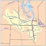
The Red River is a North America
n river. Originating at the confluence of the Bois de Sioux
and Otter Tail
rivers in the United States
, it flows northward through the Red River Valley
and forms the border between the U.S. states of Minnesota
and North Dakota
before continuing into Manitoba
, Canada
. It empties into Lake Winnipeg
, whose waters join the Nelson River
and ultimately flow into the Hudson Bay
, which is part of the Arctic Ocean
.
The Red River flows through several urban areas along its path including Fargo-Moorhead
and Greater Grand Forks
in the United States and Winnipeg
in Canada. The Red is about 885 kilometres (549.9 mi) long, of which about 635 kilometres (394.6 mi) are in the United States and about 255 kilometres (158.5 mi) are in Canada. The river falls 70 metres (230 ft) on its trip to Lake Winnipeg
where it spreads into the vast deltaic
wetland known as Netley Marsh.
In the United States, the Red River is sometimes called the Red River of the North, to distinguish it from the Red River
that is a tributary
of the Mississippi River
, and that forms part of the border between Texas
and Oklahoma
.
Long a highway for trade, the Red has been designated as a Canadian Heritage River.
, the Hudson's Bay Company
concession in north central North America. The Red was a key trade route for the company, and contributed to the settlement of British North America. The stream was used by fur trade
rs, including the Métis people
, and by the settlers of the Red River Colony
, the primary settlement of which eventually became Winnipeg
, Manitoba
. The river gave its name to the Red River Trails
, nineteenth-century oxcart trails which supported this trade and these settlements, and which led to further development of the region on both sides of the international border.
 The Red River forms at Wahpeton, North Dakota
and Breckenridge, Minnesota
, passes through Fargo, North Dakota
/Moorhead, Minnesota
and Grand Forks, North Dakota
/East Grand Forks, Minnesota
, and then continues on to the province of Manitoba
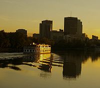
in Canada. Manitoba's capital — Winnipeg
— is at the Red's confluence with the Assiniboine River
, at a point commonly referred to as The Forks. The Red then flows further north before draining into Lake Winnipeg
which is part of the Hudson Bay
watershed
through the Nelson River
. The mouth of the Red River forms a freshwater river delta
called the Netley-Libau Marsh. The Netley Marsh
is west of the Red and the Libau Marsh is east to form a 26,000 hectare wetland.
Southern Manitoba has a comparatively long frost-free season, between 120 and 140 days in the Red River Valley.
, an enormous glacial lake
created at the end of the Wisconsin glaciation
from meltwaters of the Laurentide ice sheet
. As this continental glacier decayed, its meltwaters formed the lake, and over thousands of years sediments precipitated to the bottom of the lakebed. These lacustrine
soils are the parent soils of today's Red River Valley
. The river itself is very young; it began only after Lake Agassiz drained, about 9,500 years ago.
The word "valley" is a misnomer. While the Red River drains the region, it did not create a valley wider than a few hundred feet, and the much-wider floodplain is the lakebed of the glacial lake. It is remarkably flat; from its origin near Breckenridge, Minnesota
to the international border near Emerson, Manitoba
, its gradient is only about 1:5000 (1 metre per 5 kilometres), or approximately 1 foot per mile. The river, slow and small in most seasons, does not have the energy to cut a gorge. Instead it meanders across the silty bottomlands in its progress north. In consequence, high water has nowhere to go, except to spread across the old lakebed in "overland flooding". Heavy snows or rains, on saturated or frozen soil, has caused a number of catastophic floods, which often are made worse by the fact that snowmelt starts in the warmer south, and waters flowing northward are often dammed or slowed by ice. These periodic floods have the effect of refilling, in part, the ancient lake.
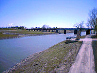
Major floods in historic times include those of 1826, 1897, 1950, 1997, and 2009, and many years in between have seen significant flooding. There have been many other floods in prehistoric times, of equal or greater size. These "paleofloods" are known from their effects on local landforms, and have been the subject of scholarly studies. Flooding has been such a concern for Winnipeg that it warranted the construction of the Red River Floodway
. Grand Forks, North Dakota took a similar precaution after the flood of 1997, constructing a removable flood wall.
As a result of the floods, a flood control project was started to ensure the same would never happen again. The Red River Floodway
around Winnipeg was cause for some derision at the time, as it seemed massively overbuilt and was the then-largest earth-moving project in the world. The project was completed under-budget, and has been used for at least some flood control twenty times in the thirty-seven years from its completion to 2006. The Floodway has saved an estimated $10 billion (CAD) in flood damages.
, The Red River spilled its banks and Red River crested in Winnipeg at the James Avenue pumping station at 19.59 feet (6 m) above datum as the sixth highest flood levels in recorded history if flood protection such as the Portage Diversion
and the Red River Floodway
were not in place. As the Red River was not a major concern in 2011, all of the attention turned to the surprise major flood on the Assiniboine River. In May 2011, a Manitoba-wide state of emergency
was declared in the wake of a 1 in 300 year flood on the Assiniboine River
at Brandon
. (CTV) (The Canadian Press) (CJOB 68)
50°23′47"N 96°48′39"W
North America
North America is a continent wholly within the Northern Hemisphere and almost wholly within the Western Hemisphere. It is also considered a northern subcontinent of the Americas...
n river. Originating at the confluence of the Bois de Sioux
Bois de Sioux River
The Bois de Sioux River drains Lake Traverse, the southernmost body of water in the Hudson Bay watershed of North America. It is a tributary of the Red River of the North and defines part of the western border of the U.S. state of Minnesota, and the eastern borders of North Dakota and South Dakota...
and Otter Tail
Otter Tail River
The Otter Tail River is a river in the west-central portion of the U.S. state of Minnesota. It begins in Clearwater County, southwest of Bemidji...
rivers in the United States
United States
The United States of America is a federal constitutional republic comprising fifty states and a federal district...
, it flows northward through the Red River Valley
Red River Valley
The Red River Valley is a region in central North America that is drained by the Red River of the North. It is significant in the geography of North Dakota, Minnesota, and Manitoba for its relatively fertile lands and the population centers of Fargo, Moorhead, Grand Forks, and Winnipeg...
and forms the border between the U.S. states of Minnesota
Minnesota
Minnesota is a U.S. state located in the Midwestern United States. The twelfth largest state of the U.S., it is the twenty-first most populous, with 5.3 million residents. Minnesota was carved out of the eastern half of the Minnesota Territory and admitted to the Union as the thirty-second state...
and North Dakota
North Dakota
North Dakota is a state located in the Midwestern region of the United States of America, along the Canadian border. The state is bordered by Canada to the north, Minnesota to the east, South Dakota to the south and Montana to the west. North Dakota is the 19th-largest state by area in the U.S....
before continuing into Manitoba
Manitoba
Manitoba is a Canadian prairie province with an area of . The province has over 110,000 lakes and has a largely continental climate because of its flat topography. Agriculture, mostly concentrated in the fertile southern and western parts of the province, is vital to the province's economy; other...
, Canada
Canada
Canada is a North American country consisting of ten provinces and three territories. Located in the northern part of the continent, it extends from the Atlantic Ocean in the east to the Pacific Ocean in the west, and northward into the Arctic Ocean...
. It empties into Lake Winnipeg
Lake Winnipeg
Lake Winnipeg is a large, lake in central North America, in the province of Manitoba, Canada, with its southern tip about north of the city of Winnipeg...
, whose waters join the Nelson River
Nelson River
The Nelson River is a river of north-central North America, in the Canadian province of Manitoba. Its full length is , it has mean discharge of , and has a drainage basin of , of which is in the United States...
and ultimately flow into the Hudson Bay
Hudson Bay
Hudson Bay , sometimes called Hudson's Bay, is a large body of saltwater in northeastern Canada. It drains a very large area, about , that includes parts of Ontario, Quebec, Saskatchewan, Alberta, most of Manitoba, southeastern Nunavut, as well as parts of North Dakota, South Dakota, Minnesota,...
, which is part of the Arctic Ocean
Arctic Ocean
The Arctic Ocean, located in the Northern Hemisphere and mostly in the Arctic north polar region, is the smallest and shallowest of the world's five major oceanic divisions...
.
The Red River flows through several urban areas along its path including Fargo-Moorhead
Fargo-Moorhead
Fargo-Moorhead is a common name given to the metropolitan area comprising Fargo, North Dakota, Moorhead, Minnesota, and the surrounding communities. These two cities lie on the North Dakota-Minnesota border, on opposite banks of the Red River of the North...
and Greater Grand Forks
Greater Grand Forks
According to the 2006–2008 American Community Survey, the population of the Greater Grand Forks metro area was 97,260, of which 50.9% were male and 49.1% were female.-Age:* Under 5 years: 6.3%* 5–9 years: 5.5%* 10–14 years: 6.1%* 15–19 years: 9.6%...
in the United States and Winnipeg
Winnipeg
Winnipeg is the capital and largest city of Manitoba, Canada, and is the primary municipality of the Winnipeg Capital Region, with more than half of Manitoba's population. It is located near the longitudinal centre of North America, at the confluence of the Red and Assiniboine Rivers .The name...
in Canada. The Red is about 885 kilometres (549.9 mi) long, of which about 635 kilometres (394.6 mi) are in the United States and about 255 kilometres (158.5 mi) are in Canada. The river falls 70 metres (230 ft) on its trip to Lake Winnipeg
Lake Winnipeg
Lake Winnipeg is a large, lake in central North America, in the province of Manitoba, Canada, with its southern tip about north of the city of Winnipeg...
where it spreads into the vast deltaic
River delta
A delta is a landform that is formed at the mouth of a river where that river flows into an ocean, sea, estuary, lake, reservoir, flat arid area, or another river. Deltas are formed from the deposition of the sediment carried by the river as the flow leaves the mouth of the river...
wetland known as Netley Marsh.
In the United States, the Red River is sometimes called the Red River of the North, to distinguish it from the Red River
Red River (Mississippi watershed)
The Red River, or sometimes the Red River of the South, is a major tributary of the Mississippi and Atchafalaya Rivers in the southern United States of America. The river gains its name from the red-bed country of its watershed. It is one of several rivers with that name...
that is a tributary
Tributary
A tributary or affluent is a stream or river that flows into a main stem river or a lake. A tributary does not flow directly into a sea or ocean...
of the Mississippi River
Mississippi River
The Mississippi River is the largest river system in North America. Flowing entirely in the United States, this river rises in western Minnesota and meanders slowly southwards for to the Mississippi River Delta at the Gulf of Mexico. With its many tributaries, the Mississippi's watershed drains...
, and that forms part of the border between Texas
Texas
Texas is the second largest U.S. state by both area and population, and the largest state by area in the contiguous United States.The name, based on the Caddo word "Tejas" meaning "friends" or "allies", was applied by the Spanish to the Caddo themselves and to the region of their settlement in...
and Oklahoma
Oklahoma
Oklahoma is a state located in the South Central region of the United States of America. With an estimated 3,751,351 residents as of the 2010 census and a land area of 68,667 square miles , Oklahoma is the 28th most populous and 20th-largest state...
.
Long a highway for trade, the Red has been designated as a Canadian Heritage River.
History
The watershed of the Red River was part of Rupert's LandRupert's Land
Rupert's Land, or Prince Rupert's Land, was a territory in British North America, consisting of the Hudson Bay drainage basin that was nominally owned by the Hudson's Bay Company for 200 years from 1670 to 1870, although numerous aboriginal groups lived in the same territory and disputed the...
, the Hudson's Bay Company
Hudson's Bay Company
The Hudson's Bay Company , abbreviated HBC, or "The Bay" is the oldest commercial corporation in North America and one of the oldest in the world. A fur trading business for much of its existence, today Hudson's Bay Company owns and operates retail stores throughout Canada...
concession in north central North America. The Red was a key trade route for the company, and contributed to the settlement of British North America. The stream was used by fur trade
Fur trade
The fur trade is a worldwide industry dealing in the acquisition and sale of animal fur. Since the establishment of world market for in the early modern period furs of boreal, polar and cold temperate mammalian animals have been the most valued...
rs, including the Métis people
Métis people (Canada)
The Métis are one of the Aboriginal peoples in Canada who trace their descent to mixed First Nations parentage. The term was historically a catch-all describing the offspring of any such union, but within generations the culture syncretised into what is today a distinct aboriginal group, with...
, and by the settlers of the Red River Colony
Red River Colony
The Red River Colony was a colonization project set up by Thomas Douglas, 5th Earl of Selkirk in 1811 on of land granted to him by the Hudson's Bay Company under what is referred to as the Selkirk Concession. The colony along the Red River of the North was never very successful...
, the primary settlement of which eventually became Winnipeg
Winnipeg
Winnipeg is the capital and largest city of Manitoba, Canada, and is the primary municipality of the Winnipeg Capital Region, with more than half of Manitoba's population. It is located near the longitudinal centre of North America, at the confluence of the Red and Assiniboine Rivers .The name...
, Manitoba
Manitoba
Manitoba is a Canadian prairie province with an area of . The province has over 110,000 lakes and has a largely continental climate because of its flat topography. Agriculture, mostly concentrated in the fertile southern and western parts of the province, is vital to the province's economy; other...
. The river gave its name to the Red River Trails
Red River Trails
The Red River Trails were a network of ox cart routes connecting the Red River Colony and Fort Garry in British North America with the head of navigation on the Mississippi River in the United States...
, nineteenth-century oxcart trails which supported this trade and these settlements, and which led to further development of the region on both sides of the international border.
Geography
Wahpeton, North Dakota
The first European explorer in the area was Jonathan Carver in 1767. He explored and mapped the Northwest at the request of Major Robert Rogers, commander of Fort Michilimackinac, the British fort at Mackinaw City, Michigan, which protected the passage between Lake Michigan and Lake Huron...
and Breckenridge, Minnesota
Breckenridge, Minnesota
As of the census of 2000, there were 3,559 people, 1,438 households, and 911 families residing in the city. The population density was 1,516.4 people per square mile . There were 1,582 housing units at an average density of 674.0 per square mile...
, passes through Fargo, North Dakota
Fargo, North Dakota
Fargo is the largest city in the U.S. state of North Dakota and the county seat of Cass County. In 2010, its population was 105,549, and it had an estimated metropolitan population of 208,777...
/Moorhead, Minnesota
Moorhead, Minnesota
Moorhead is a city in Clay County, Minnesota, United States, and the largest city in northwest Minnesota. The population was 38,065 at the 2010 Census. It is the county seat of Clay County....
and Grand Forks, North Dakota
Grand Forks, North Dakota
Grand Forks is the third-largest city in the U.S. state of North Dakota and the county seat of Grand Forks County. According to the 2010 census, the city's population was 52,838, while that of the city and surrounding metropolitan area was 98,461...
/East Grand Forks, Minnesota
East Grand Forks, Minnesota
-K-12:The East Grand Forks School District enrolls over 1,000 students and operates two elementary schools , Central Middle School, and East Grand Forks Senior High School. There are also two private Christian schools. Sacred Heart School is a Roman Catholic elementary, middle, and high school...
, and then continues on to the province of Manitoba
Manitoba
Manitoba is a Canadian prairie province with an area of . The province has over 110,000 lakes and has a largely continental climate because of its flat topography. Agriculture, mostly concentrated in the fertile southern and western parts of the province, is vital to the province's economy; other...
in Canada. Manitoba's capital — Winnipeg
Winnipeg
Winnipeg is the capital and largest city of Manitoba, Canada, and is the primary municipality of the Winnipeg Capital Region, with more than half of Manitoba's population. It is located near the longitudinal centre of North America, at the confluence of the Red and Assiniboine Rivers .The name...
— is at the Red's confluence with the Assiniboine River
Assiniboine River
The Assiniboine River is a river that runs through the prairies of Western Canada in Saskatchewan and Manitoba. It is a tributary of the Red River. The Assiniboine is a typical meandering river with a single main channel embanked within a flat, shallow valley in some places and a steep valley in...
, at a point commonly referred to as The Forks. The Red then flows further north before draining into Lake Winnipeg
Lake Winnipeg
Lake Winnipeg is a large, lake in central North America, in the province of Manitoba, Canada, with its southern tip about north of the city of Winnipeg...
which is part of the Hudson Bay
Hudson Bay
Hudson Bay , sometimes called Hudson's Bay, is a large body of saltwater in northeastern Canada. It drains a very large area, about , that includes parts of Ontario, Quebec, Saskatchewan, Alberta, most of Manitoba, southeastern Nunavut, as well as parts of North Dakota, South Dakota, Minnesota,...
watershed
Drainage basin
A drainage basin is an extent or an area of land where surface water from rain and melting snow or ice converges to a single point, usually the exit of the basin, where the waters join another waterbody, such as a river, lake, reservoir, estuary, wetland, sea, or ocean...
through the Nelson River
Nelson River
The Nelson River is a river of north-central North America, in the Canadian province of Manitoba. Its full length is , it has mean discharge of , and has a drainage basin of , of which is in the United States...
. The mouth of the Red River forms a freshwater river delta
River delta
A delta is a landform that is formed at the mouth of a river where that river flows into an ocean, sea, estuary, lake, reservoir, flat arid area, or another river. Deltas are formed from the deposition of the sediment carried by the river as the flow leaves the mouth of the river...
called the Netley-Libau Marsh. The Netley Marsh
Netley Marsh
Netley Marsh is a village and civil parish in Hampshire, UK, close to the town of Totton. It lies within the New Forest District council, and the New Forest National Park. It is the alleged site of the battle between an invading Anglo Saxon army, under Cerdic and a British army under Natanleod in...
is west of the Red and the Libau Marsh is east to form a 26,000 hectare wetland.
Southern Manitoba has a comparatively long frost-free season, between 120 and 140 days in the Red River Valley.
Geology
The Red River flows across the flat lakebed of the ancient glacial Lake AgassizLake Agassiz
Lake Agassiz was an immense glacial lake located in the center of North America. Fed by glacial runoff at the end of the last glacial period, its area was larger than all of the modern Great Lakes combined, and it held more water than contained by all lakes in the world today.-Conception:First...
, an enormous glacial lake
Glacial lake
A glacial lake is a lake with origins in a melted glacier. Near the end of the last glacial period, roughly 10,000 years ago, glaciers began to retreat. A retreating glacier often left behind large deposits of ice in hollows between drumlins or hills. As the ice age ended, these melted to create...
created at the end of the Wisconsin glaciation
Wisconsin glaciation
The last glacial period was the most recent glacial period within the current ice age occurring during the last years of the Pleistocene, from approximately 110,000 to 10,000 years ago....
from meltwaters of the Laurentide ice sheet
Laurentide ice sheet
The Laurentide Ice Sheet was a massive sheet of ice that covered hundreds of thousands of square miles, including most of Canada and a large portion of the northern United States, multiple times during Quaternary glacial epochs. It last covered most of northern North America between c. 95,000 and...
. As this continental glacier decayed, its meltwaters formed the lake, and over thousands of years sediments precipitated to the bottom of the lakebed. These lacustrine
Lake
A lake is a body of relatively still fresh or salt water of considerable size, localized in a basin, that is surrounded by land. Lakes are inland and not part of the ocean and therefore are distinct from lagoons, and are larger and deeper than ponds. Lakes can be contrasted with rivers or streams,...
soils are the parent soils of today's Red River Valley
Red River Valley
The Red River Valley is a region in central North America that is drained by the Red River of the North. It is significant in the geography of North Dakota, Minnesota, and Manitoba for its relatively fertile lands and the population centers of Fargo, Moorhead, Grand Forks, and Winnipeg...
. The river itself is very young; it began only after Lake Agassiz drained, about 9,500 years ago.
The word "valley" is a misnomer. While the Red River drains the region, it did not create a valley wider than a few hundred feet, and the much-wider floodplain is the lakebed of the glacial lake. It is remarkably flat; from its origin near Breckenridge, Minnesota
Breckenridge, Minnesota
As of the census of 2000, there were 3,559 people, 1,438 households, and 911 families residing in the city. The population density was 1,516.4 people per square mile . There were 1,582 housing units at an average density of 674.0 per square mile...
to the international border near Emerson, Manitoba
Emerson, Manitoba
Emerson is a town in south central Manitoba, Canada, with a population of 655. The town is named after writer Ralph Waldo Emerson.Emerson is located on the east bank of the Red River, just north of the border with the United States at the point where Manitoba, Minnesota, and North Dakota meet. ...
, its gradient is only about 1:5000 (1 metre per 5 kilometres), or approximately 1 foot per mile. The river, slow and small in most seasons, does not have the energy to cut a gorge. Instead it meanders across the silty bottomlands in its progress north. In consequence, high water has nowhere to go, except to spread across the old lakebed in "overland flooding". Heavy snows or rains, on saturated or frozen soil, has caused a number of catastophic floods, which often are made worse by the fact that snowmelt starts in the warmer south, and waters flowing northward are often dammed or slowed by ice. These periodic floods have the effect of refilling, in part, the ancient lake.
Major floods in historic times include those of 1826, 1897, 1950, 1997, and 2009, and many years in between have seen significant flooding. There have been many other floods in prehistoric times, of equal or greater size. These "paleofloods" are known from their effects on local landforms, and have been the subject of scholarly studies. Flooding has been such a concern for Winnipeg that it warranted the construction of the Red River Floodway
Red River Floodway
The Red River Floodway is an artificial flood control waterway in Western Canada, first used in 1969. It is a long channel which, during flood periods, takes part of the Red River's flow around the city of Winnipeg, Manitoba to the east and discharges it back into the Red River below the dam at...
. Grand Forks, North Dakota took a similar precaution after the flood of 1997, constructing a removable flood wall.
1950 flood
On May 8, 1950 the Red River reached its highest level at Winnipeg since 1861. Eight dikes protecting Winnipeg gave way and flooded much of the city, turning 600 square miles (1,554 km²) of farmland into an enormous lake. The city turned to the Canadian Army and the Red Cross for help, and nearly 70,000 people were evacuated from their homes and businesses. Four of eleven bridges in the city were destroyed, and damage was estimated at between $900 million and $1 billion.As a result of the floods, a flood control project was started to ensure the same would never happen again. The Red River Floodway
Red River Floodway
The Red River Floodway is an artificial flood control waterway in Western Canada, first used in 1969. It is a long channel which, during flood periods, takes part of the Red River's flow around the city of Winnipeg, Manitoba to the east and discharges it back into the Red River below the dam at...
around Winnipeg was cause for some derision at the time, as it seemed massively overbuilt and was the then-largest earth-moving project in the world. The project was completed under-budget, and has been used for at least some flood control twenty times in the thirty-seven years from its completion to 2006. The Floodway has saved an estimated $10 billion (CAD) in flood damages.
1997 flood
In the spring of 1997 a major flood of the Red River caused $3.5 billion in damage and required temporary evacuation of towns and cities on both sides of the border. The flood crested at 24.5 feet (7.5 m) above datum at the James Avenue pumping station in Winnipeg making it the third highest flood at Winnipeg in recorded history only being surpassed by the floods of 1852, and 1826.2009 flood
In 2009 the Red River flooded in early spring. By Friday, March 27, the river at Fargo had reached the highest level in recorded history, and its discharge at that location was far in excess of normal flows. The water ended up cresting at the James Avenue pumping station in Winnipeg at 22.5 feet (6.9 m) above datum making it the fourth highest flood in recorded history.2011 Flood
Due to a wet summer in 2010 as well as an above average amount of snowfall in the Red River ValleyRed River Valley
The Red River Valley is a region in central North America that is drained by the Red River of the North. It is significant in the geography of North Dakota, Minnesota, and Manitoba for its relatively fertile lands and the population centers of Fargo, Moorhead, Grand Forks, and Winnipeg...
, The Red River spilled its banks and Red River crested in Winnipeg at the James Avenue pumping station at 19.59 feet (6 m) above datum as the sixth highest flood levels in recorded history if flood protection such as the Portage Diversion
Portage Diversion
The Portage Diversion is a water control structure on the Assiniboine River in Portage la Prairie, Manitoba, Canada. The project was made as part of a larger attempt to prevent flooding in the Red River Valley...
and the Red River Floodway
Red River Floodway
The Red River Floodway is an artificial flood control waterway in Western Canada, first used in 1969. It is a long channel which, during flood periods, takes part of the Red River's flow around the city of Winnipeg, Manitoba to the east and discharges it back into the Red River below the dam at...
were not in place. As the Red River was not a major concern in 2011, all of the attention turned to the surprise major flood on the Assiniboine River. In May 2011, a Manitoba-wide state of emergency
State of emergency
A state of emergency is a governmental declaration that may suspend some normal functions of the executive, legislative and judicial powers, alert citizens to change their normal behaviours, or order government agencies to implement emergency preparedness plans. It can also be used as a rationale...
was declared in the wake of a 1 in 300 year flood on the Assiniboine River
Assiniboine River
The Assiniboine River is a river that runs through the prairies of Western Canada in Saskatchewan and Manitoba. It is a tributary of the Red River. The Assiniboine is a typical meandering river with a single main channel embanked within a flat, shallow valley in some places and a steep valley in...
at Brandon
Brandon, Manitoba
Brandon is the second largest city in Manitoba, Canada, and is located in the southwestern area of the province. Brandon is the largest city in the Westman region of Manitoba. The city is located along the Assiniboine River. Spruce Woods Provincial Park and CFB Shilo are a relatively short distance...
. (CTV) (The Canadian Press) (CJOB 68)
See also
- List of longest rivers of Canada
- List of longest rivers of the United States (by main stem)
- List of rivers of the United States
- Red River, other rivers with the same name
External links
- Canadian Council for Geographic Education page with a series of articles on the history of the Red River.
- Geological Survey of Canada page describing the nature and history of Red River floods.
- Minnesota DNR Red River website
- U.S. Geological Survey Reports and Abstracts Related to the Red River of the North
- Water Quality in the Red River of the North
- Fish of the Red River–Red River Angler's Guide
- North Dakota State University's Fargo Flood website
50°23′47"N 96°48′39"W