
Boise River
Encyclopedia
The Boise River is a 102 miles (164.2 km) tributary
of the Snake River
in the northwestern United States
. It drains a rugged portion of the Sawtooth Range
in southwestern Idaho
northeast of Boise
, as well as part of the western Snake River Plain
. The watershed encompasses approximately 4100 square miles (10,619 km²) of highly diverse habitats, including alpine canyons, forest, rangeland, agricultural
lands, and urban areas.
s exceeding 10000 feet (3,048 m), and is formed by the confluence of its North and Middle forks. The North Fork, 50 miles (80.5 km) long, rises in the Sawtooth Wilderness Area
, along the Boise-Elmore
county line, 60 mile northeast of Boise. It flows generally southwest through the remote mountains in the Boise National Forest
. The Middle Fork, approximately 52 miles (83.7 km) in length, rises within 12 miles (19.3 km) of the North Fork in the southern Sawtooth Wilderness
Area in northeastern Elmore County. It flows west-southwest near the town of Atlanta
, joining the North Fork to form the Boise River, approximately 15 miles (24.1 km) southeast of Idaho City
. The main stream flows southwest into Arrowrock Reservoir
joining the South Fork from the Anderson Ranch Dam
.
 The 101 miles (162.5 km) South Fork rises in northern Camas County
in the Smoky Mountains of the Sawtooth National Forest
north of Fairfield
, 65 miles (104.6 km) east of Boise. It flows generally southwest, descending through a basalt
canyon to fill the Anderson Ranch Reservoir
, then turns northwest in central Elmore County. It joins the main stream as the southern arm of Arrowrock Reservoir, 20 miles (32.2 km) east of Boise.
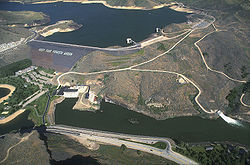
Downstream from its confluence with the South Fork, the river flows generally west, and adds the major tributary of Mores Creek along Highway 21
, and passes through Lucky Peak Dam
to emerge from the foothills, southeast of Boise. It passes over several irrigation diversion dams above the city. The first and largest is the century-old Boise River Diversion Dam
for the concrete New York Canal, which terminates at Lake Lowell (a.k.a. Deer Flat Reservoir) southwest of Nampa
in Canyon County
. As the river passes through downtown Boise, it is lined by an extensive recreational greenbelt
. The Boise River then flows west across the western end of the Snake River Plain, it becomes a braided stream with a wide floodplain
as it crosses northern Canyon County
to the Snake River
. It enters the Snake River, the Idaho-Oregon
border, west of Parma
and three miles (5 km) south of Nyssa
, Oregon
.
on the plain west of Boise. The dams that form the mountain reservoirs were constructed as part of the Bureau of Reclamation's
"Boise Project" to provide agricultural irrigation, hydroelectricity
, drinking water, and flood
control to Boise and the Treasure Valley
.
The major projects' initial completion dates were:
during hot, dry summer afternoons. Tubers and floaters launch at Barber Park and land at Ann Morrison Park, between major irrigation diversion dams. Several minor diversion weirs are passed as well as several bridges on the 5 mile (8 km) trip. Water skiing
is popular above the dam at the Lucky Peak Reservoir.
On the lower (warmwater) course of the river, low summer flows and poorer water quality from agricultural runoff limit fishery
production. This section of river supports a fair fishery for largemouth bass
, smallmouth bass, and channel catfish
. Upstream from Star
, the river is a coldwater stream and supports a greater variety of fish. The most prevalent species on this section is mountain whitefish
, as well as hatchery-reared rainbow trout
, wild rainbow trout, and fingerling brown trout
. Upstream from Lucky Peak and Arrowrock reservoirs, the river and its tributaries contain excellent populations of wild rainbow trout, mountain whitefish, and bull trout. This is especially true immediately downstream from the outflow of Anderson Ranch reservoir, where the South Fork takes on the characteristics of a classic "tailwater" for over five miles from the put-in below the dam to Cow Creek Bridge.
, mostly for rainbow trout
and, in the winter, steelhead. Spinfishermen use roostertail spinners and bait
such as worm
s and powerbait while fly fishermen
use a variety of nymphs, streamers
, and dry flies
.
Tributary
A tributary or affluent is a stream or river that flows into a main stem river or a lake. A tributary does not flow directly into a sea or ocean...
of the Snake River
Snake River
The Snake is a major river of the greater Pacific Northwest in the United States. At long, it is the largest tributary of the Columbia River, the largest North American river that empties into the Pacific Ocean...
in the northwestern United States
United States
The United States of America is a federal constitutional republic comprising fifty states and a federal district...
. It drains a rugged portion of the Sawtooth Range
Sawtooth Range (Idaho)
The Sawtooth Range is part of the Rocky Mountains, located within a few miles south of Stanley, Idaho, in the Western United States. Much of mountain range is within the Sawtooth Wilderness, part of the Sawtooth National Recreation Area...
in southwestern Idaho
Idaho
Idaho is a state in the Rocky Mountain area of the United States. The state's largest city and capital is Boise. Residents are called "Idahoans". Idaho was admitted to the Union on July 3, 1890, as the 43rd state....
northeast of Boise
Boise, Idaho
Boise is the capital and most populous city of the U.S. state of Idaho, as well as the county seat of Ada County. Located on the Boise River, it anchors the Boise City-Nampa metropolitan area and is the largest city between Salt Lake City, Utah and Portland, Oregon.As of the 2010 Census Bureau,...
, as well as part of the western Snake River Plain
Snake River Plain
The Snake River Plain is a geologic feature located primarily within the state of Idaho in the United States of America. It stretches about westward from northwest of the state of Wyoming to the Idaho-Oregon border. The plain is a wide flat bow-shaped depression, and covers about a quarter of Idaho...
. The watershed encompasses approximately 4100 square miles (10,619 km²) of highly diverse habitats, including alpine canyons, forest, rangeland, agricultural
Agriculture
Agriculture is the cultivation of animals, plants, fungi and other life forms for food, fiber, and other products used to sustain life. Agriculture was the key implement in the rise of sedentary human civilization, whereby farming of domesticated species created food surpluses that nurtured the...
lands, and urban areas.
Description
The Boise River rises in three separate forks in the Sawtooth Range at elevationElevation
The elevation of a geographic location is its height above a fixed reference point, most commonly a reference geoid, a mathematical model of the Earth's sea level as an equipotential gravitational surface ....
s exceeding 10000 feet (3,048 m), and is formed by the confluence of its North and Middle forks. The North Fork, 50 miles (80.5 km) long, rises in the Sawtooth Wilderness Area
Sawtooth Wilderness
The Sawtooth Wilderness is located in the U.S. state of Idaho. Managed by the U.S. Forest Service in the Sawtooth National Recreation Area. The Wilderness was upgraded in 1972 from "primitive area" status, affording greater protections of the habitat...
, along the Boise-Elmore
Elmore County, Idaho
Elmore County is a county located in the U.S. state of Idaho. As of the 2010 Census the county had a population of 27,038, down 7.2% from 29,130 in 2000. The largest city and county seat is Mountain Home....
county line, 60 mile northeast of Boise. It flows generally southwest through the remote mountains in the Boise National Forest
Boise National Forest
The Boise National Forest is a US national forest located north and east of the city of Boise, Idaho. It is about 2,612,000 acres in size, ranging in elevation from 2,600 to 9,800 feet . The mountainous landscape developed through uplifting, faulting, and stream cutting...
. The Middle Fork, approximately 52 miles (83.7 km) in length, rises within 12 miles (19.3 km) of the North Fork in the southern Sawtooth Wilderness
Sawtooth Wilderness
The Sawtooth Wilderness is located in the U.S. state of Idaho. Managed by the U.S. Forest Service in the Sawtooth National Recreation Area. The Wilderness was upgraded in 1972 from "primitive area" status, affording greater protections of the habitat...
Area in northeastern Elmore County. It flows west-southwest near the town of Atlanta
Atlanta, Idaho
Atlanta is an unincorporated town in Elmore County, Idaho, United States. It was founded in 1864 during the Civil War as a gold and silver mining community and named by Southerners after a rumored Confederate victory over General Sherman in the Battle of Atlanta, which turned to be wholly false,...
, joining the North Fork to form the Boise River, approximately 15 miles (24.1 km) southeast of Idaho City
Idaho City, Idaho
Idaho City is a city in and the county seat of Boise County, Idaho, United States, located about northeast of Boise. The population was 458 at the 2000 census.Idaho City is part of the Boise City–Nampa, Idaho Metropolitan Statistical Area.-History:...
. The main stream flows southwest into Arrowrock Reservoir
Arrowrock Dam
Arrowrock Dam is a concrete arch type dam on the Boise River, in Idaho, U.S.A. It opened in 1915 and is located on the border between Boise County and Elmore County, upstream of the Lucky Peak Dam and reservoir...
joining the South Fork from the Anderson Ranch Dam
Anderson Ranch Dam
Anderson Ranch Dam is an earth rockfill type dam on the South Fork of the Boise River, in Elmore County, Idaho, U.S.A. Its reservoir is plainly called "Anderson Ranch Reservoir" and has a spillway elevation of 4196 feet above sea level...
.
Camas County, Idaho
Camas County is a county in the southern portion of the U.S. state of Idaho. As of the 2000 Census, the rural county had a population of 991 . The county seat is Fairfield....
in the Smoky Mountains of the Sawtooth National Forest
Sawtooth National Forest
Sawtooth National Forest is in Idaho and Utah was protected in 1905 by U.S. President Theodore Roosevelt as the Sawtooth Forest Reserve. Today the forest administers over 2.1 million acres of some of the most remote forestland in the lower 48 states, and there are over 1,000 lakes and 3,000...
north of Fairfield
Fairfield, Idaho
Fairfield is the county seat of and the only city in Camas County, Idaho, United States. The population was 395 at the 2000 census, nearly half of the rural county's population.-Geography:...
, 65 miles (104.6 km) east of Boise. It flows generally southwest, descending through a basalt
Basalt
Basalt is a common extrusive volcanic rock. It is usually grey to black and fine-grained due to rapid cooling of lava at the surface of a planet. It may be porphyritic containing larger crystals in a fine matrix, or vesicular, or frothy scoria. Unweathered basalt is black or grey...
canyon to fill the Anderson Ranch Reservoir
Anderson Ranch Dam
Anderson Ranch Dam is an earth rockfill type dam on the South Fork of the Boise River, in Elmore County, Idaho, U.S.A. Its reservoir is plainly called "Anderson Ranch Reservoir" and has a spillway elevation of 4196 feet above sea level...
, then turns northwest in central Elmore County. It joins the main stream as the southern arm of Arrowrock Reservoir, 20 miles (32.2 km) east of Boise.
Downstream from its confluence with the South Fork, the river flows generally west, and adds the major tributary of Mores Creek along Highway 21
Idaho State Highway 21
Idaho State Highway 21 is the Ponderosa Pine Scenic Byway, primarily a two-lane highway from Boise to Stanley. With two-thirds of its length in Boise County, it passes by historic Idaho City and the village of Lowman to the western edge of the Sawtooth Mountains, then along their northern...
, and passes through Lucky Peak Dam
Lucky Peak Dam
Lucky Peak Dam is a rolled earth and gravel fill dam on the Boise River in Ada County, Idaho, U.S.A.. It is directly downstream of Arrowrock Dam, a concrete arch structure completed in 1915. At the time of its construction in the early 1950s, Lucky Peak's primary purpose was flood control, with a...
to emerge from the foothills, southeast of Boise. It passes over several irrigation diversion dams above the city. The first and largest is the century-old Boise River Diversion Dam
Boise River Diversion Dam
The Boise River Diversion Dam is a diversion dam on the Boise River in Idaho.In March, 1906 the Utah Fire Proofing Company began work on the Boise River Diversion Dam with the provision that the structure would be completed within one year. It soon became apparent that the dam would not be finished...
for the concrete New York Canal, which terminates at Lake Lowell (a.k.a. Deer Flat Reservoir) southwest of Nampa
Nampa, Idaho
Nampa is the largest and the fastest growing city in Canyon County, Idaho, USA. The population of Nampa was 81,557 at the 2010 census. Nampa is located about west of Boise along Interstate 84, and six miles west of Meridian. Nampa is part of the Boise metropolitan area...
in Canyon County
Canyon County, Idaho
Canyon County is a county located in the U.S. state of Idaho. As of the 2010 Census the county had a population of 188,923. The county seat is Caldwell, and its largest city is Nampa.. Canyon County is part of the Boise City–Nampa, Idaho Metropolitan Statistical Area.- History :The county was...
. As the river passes through downtown Boise, it is lined by an extensive recreational greenbelt
Boise greenbelt
The Boise River Greenbelt is a recreational and alternate transportation trail along the banks of the Boise River through Boise, Idaho, U.S.A.. The Boise Greenbelt is more of a greenway than a green belt since its character is linear...
. The Boise River then flows west across the western end of the Snake River Plain, it becomes a braided stream with a wide floodplain
Floodplain
A floodplain, or flood plain, is a flat or nearly flat land adjacent a stream or river that stretches from the banks of its channel to the base of the enclosing valley walls and experiences flooding during periods of high discharge...
as it crosses northern Canyon County
Canyon County, Idaho
Canyon County is a county located in the U.S. state of Idaho. As of the 2010 Census the county had a population of 188,923. The county seat is Caldwell, and its largest city is Nampa.. Canyon County is part of the Boise City–Nampa, Idaho Metropolitan Statistical Area.- History :The county was...
to the Snake River
Snake River
The Snake is a major river of the greater Pacific Northwest in the United States. At long, it is the largest tributary of the Columbia River, the largest North American river that empties into the Pacific Ocean...
. It enters the Snake River, the Idaho-Oregon
Oregon
Oregon is a state in the Pacific Northwest region of the United States. It is located on the Pacific coast, with Washington to the north, California to the south, Nevada on the southeast and Idaho to the east. The Columbia and Snake rivers delineate much of Oregon's northern and eastern...
border, west of Parma
Parma, Idaho
Parma is a city in Canyon County, Idaho, United States. The population was 1,771 at the 2000 census. It is part of the Boise City–Nampa, Idaho Metropolitan Statistical Area.-Geography:Parma is located at ....
and three miles (5 km) south of Nyssa
Nyssa, Oregon
Nyssa is a city in Malheur County, Oregon, United States. The population was 3,163 at the 2000 census. The city is located along the Snake River on the Idaho border, in the region of far eastern Oregon known as the "Treasure Valley"...
, Oregon
Oregon
Oregon is a state in the Pacific Northwest region of the United States. It is located on the Pacific coast, with Washington to the north, California to the south, Nevada on the southeast and Idaho to the east. The Columbia and Snake rivers delineate much of Oregon's northern and eastern...
.
History
The river was called "Reed's River" in the early 19th century, explored during 1811 Astorian Expedition. The river is used for irrigationIrrigation
Irrigation may be defined as the science of artificial application of water to the land or soil. It is used to assist in the growing of agricultural crops, maintenance of landscapes, and revegetation of disturbed soils in dry areas and during periods of inadequate rainfall...
on the plain west of Boise. The dams that form the mountain reservoirs were constructed as part of the Bureau of Reclamation's
United States Bureau of Reclamation
The United States Bureau of Reclamation , and formerly the United States Reclamation Service , is an agency under the U.S...
"Boise Project" to provide agricultural irrigation, hydroelectricity
Hydroelectricity
Hydroelectricity is the term referring to electricity generated by hydropower; the production of electrical power through the use of the gravitational force of falling or flowing water. It is the most widely used form of renewable energy...
, drinking water, and flood
Flood
A flood is an overflow of an expanse of water that submerges land. The EU Floods directive defines a flood as a temporary covering by water of land not normally covered by water...
control to Boise and the Treasure Valley
Treasure Valley
The Treasure Valley is the area of the Western United States where the Payette, Boise, Weiser, Malheur, Owyhee, and Burnt rivers drain into the Snake River. Treasure Valley includes all the lowland areas from Vale, Oregon on the west to Boise, Idaho on the east. Formerly, the valley had been known...
.
The major projects' initial completion dates were:
- 1909 - Boise River Diversion DamBoise River Diversion DamThe Boise River Diversion Dam is a diversion dam on the Boise River in Idaho.In March, 1906 the Utah Fire Proofing Company began work on the Boise River Diversion Dam with the provision that the structure would be completed within one year. It soon became apparent that the dam would not be finished...
& New York Canal - 1915 - Arrowrock DamArrowrock DamArrowrock Dam is a concrete arch type dam on the Boise River, in Idaho, U.S.A. It opened in 1915 and is located on the border between Boise County and Elmore County, upstream of the Lucky Peak Dam and reservoir...
- 1950 - Anderson Ranch DamAnderson Ranch DamAnderson Ranch Dam is an earth rockfill type dam on the South Fork of the Boise River, in Elmore County, Idaho, U.S.A. Its reservoir is plainly called "Anderson Ranch Reservoir" and has a spillway elevation of 4196 feet above sea level...
- (S. Fork) - 1955 - Lucky Peak DamLucky Peak DamLucky Peak Dam is a rolled earth and gravel fill dam on the Boise River in Ada County, Idaho, U.S.A.. It is directly downstream of Arrowrock Dam, a concrete arch structure completed in 1915. At the time of its construction in the early 1950s, Lucky Peak's primary purpose was flood control, with a...
- (U.S. ArmyUnited States ArmyThe United States Army is the main branch of the United States Armed Forces responsible for land-based military operations. It is the largest and oldest established branch of the U.S. military, and is one of seven U.S. uniformed services...
Corps of EngineersUnited States Army Corps of EngineersThe United States Army Corps of Engineers is a federal agency and a major Army command made up of some 38,000 civilian and military personnel, making it the world's largest public engineering, design and construction management agency...
)
Recreation
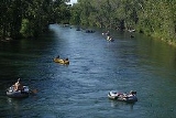
The river is a popular destination for floating, specifically on the urban tree-lined run through BoiseBoise greenbelt
The Boise River Greenbelt is a recreational and alternate transportation trail along the banks of the Boise River through Boise, Idaho, U.S.A.. The Boise Greenbelt is more of a greenway than a green belt since its character is linear...
during hot, dry summer afternoons. Tubers and floaters launch at Barber Park and land at Ann Morrison Park, between major irrigation diversion dams. Several minor diversion weirs are passed as well as several bridges on the 5 mile (8 km) trip. Water skiing
Water skiing
thumb|right|A slalom skier making a turn on a slalom waterski.Waterskiing is a sport where an individual is pulled behind a boat or a cable ski installation on a body of water, skimming the surface.-History:...
is popular above the dam at the Lucky Peak Reservoir.
On the lower (warmwater) course of the river, low summer flows and poorer water quality from agricultural runoff limit fishery
Fishery
Generally, a fishery is an entity engaged in raising or harvesting fish which is determined by some authority to be a fishery. According to the FAO, a fishery is typically defined in terms of the "people involved, species or type of fish, area of water or seabed, method of fishing, class of boats,...
production. This section of river supports a fair fishery for largemouth bass
Largemouth bass
The largemouth bass is a species of black bass in the sunfish family native to North America . It is also known as widemouth bass, bigmouth, black bass, bucketmouth, Potter's fish, Florida bass, Florida largemouth, green bass, green trout, linesides, Oswego bass, southern largemouth...
, smallmouth bass, and channel catfish
Catfish
Catfishes are a diverse group of ray-finned fish. Named for their prominent barbels, which resemble a cat's whiskers, catfish range in size and behavior from the heaviest and longest, the Mekong giant catfish from Southeast Asia and the second longest, the wels catfish of Eurasia, to detritivores...
. Upstream from Star
Star, Idaho
Star is a city in northwestern Ada County, Idaho, United States. The population was 1,795 at the 2000 census. It was named in the 19th century by travelers on their way to Middleton and Boise who used the star on the school house to find east and west. The name stuck and it became Star, Idaho...
, the river is a coldwater stream and supports a greater variety of fish. The most prevalent species on this section is mountain whitefish
Mountain whitefish
The mountain whitefish is one of the most widely distributed salmonid fish of western North America. It is found from the Mackenzie River drainage in Northwest Territory, Canada south through western Canada and the northwestern USA in the Pacific, Hudson Bay and upper Missouri River basins to the...
, as well as hatchery-reared rainbow trout
Trout
Trout is the name for a number of species of freshwater and saltwater fish belonging to the Salmoninae subfamily of the family Salmonidae. Salmon belong to the same family as trout. Most salmon species spend almost all their lives in salt water...
, wild rainbow trout, and fingerling brown trout
Brown trout
The brown trout and the sea trout are fish of the same species....
. Upstream from Lucky Peak and Arrowrock reservoirs, the river and its tributaries contain excellent populations of wild rainbow trout, mountain whitefish, and bull trout. This is especially true immediately downstream from the outflow of Anderson Ranch reservoir, where the South Fork takes on the characteristics of a classic "tailwater" for over five miles from the put-in below the dam to Cow Creek Bridge.
Fishing
The Boise river is also used for fishingFishing
Fishing is the activity of trying to catch wild fish. Fish are normally caught in the wild. Techniques for catching fish include hand gathering, spearing, netting, angling and trapping....
, mostly for rainbow trout
Rainbow trout
The rainbow trout is a species of salmonid native to tributaries of the Pacific Ocean in Asia and North America. The steelhead is a sea run rainbow trout usually returning to freshwater to spawn after 2 to 3 years at sea. In other words, rainbow trout and steelhead trout are the same species....
and, in the winter, steelhead. Spinfishermen use roostertail spinners and bait
Bait (luring substance)
Bait is any substance used to attract prey, e.g. in a mousetrap.-In Australia:Baiting in Australia refers to specific campaigns to control foxes, wild dogs and dingos by poisoning in areas where they are a problem...
such as worm
Worm
The term worm refers to an obsolete taxon used by Carolus Linnaeus and Jean-Baptiste Lamarck for all non-arthropod invertebrate animals, and stems from the Old English word wyrm. Currently it is used to describe many different distantly-related animals that typically have a long cylindrical...
s and powerbait while fly fishermen
Fly fishing
Fly fishing is an angling method in which an artificial 'fly' is used to catch fish. The fly is cast using a fly rod, reel, and specialized weighted line. Casting a nearly weightless fly or 'lure' requires casting techniques significantly different from other forms of casting...
use a variety of nymphs, streamers
Artificial fly
An artificial fly or fly lure is a type of fishing lure, usually used in the sport of fly fishing . In general, artificial flies are the bait which fly fishers present to their target species of fish while fly fishing...
, and dry flies
Fließ
Fließ is a municipality in the Landeck district and is located5 km south of Landeck on the upper course of the Inn River. It has 9 hamlets and was already populated at the roman age; the village itself was founded around the 6th century. After a conflagration in 1933 Fließ was restored more...
.