
Interstate 80
Encyclopedia
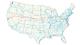
Interstate 80 is the second-longest Interstate Highway in the United States
, following Interstate 90
. It is a transcontinental artery running from downtown San Francisco, California to Teaneck, New Jersey
in the New York City Metropolitan Area. I-80 is the Interstate Highway that most closely approximates the route of the historic Lincoln Highway
, the first road across America
. The highway roughly traces other historically significant travel routes in the Western United States
: the Oregon Trail
across Wyoming
and Nebraska
, the California Trail
across most of Nevada
and California
, and except in the Great Salt Lake
area, the entire route of the First Transcontinental Railroad
.
From near Chicago, Illinois, east to near Youngstown, Ohio
, Interstate 80 is a toll road
, containing the majority of both the Indiana Toll Road
and the Ohio Turnpike
. I-80 runs concurrent
with Interstate 90
from near Portage, Indiana
to Elyria, Ohio
. I-80 becomes the Keystone Shortway, a freeway built across rural northern Pennsylvania expressly for I-80, with its eastern origin at its junction with the New Jersey Turnpike
and Interstate 95
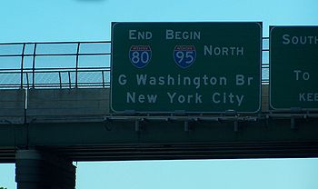
just west of the George Washington Bridge
entering New York City
.
|CA
|199.24
|320.65
|-
|NV
|410.67
|660.91
|-
|UT
|196.34
|315.98
|-
|WY
|402.76
|648.18
|-
|NE
|455.32
|732.77
|-
|IA
|306.01
|492.48
|-
|IL
|163.52
|263.16
|-
|IN
|151.56
|243.91
|-
|OH
|237.48
|382.19
|-
|PA
|311.07
|500.62
|-
|NJ
|68.54
|110.30
|-
|Total
|2902.51
|4671.13
|}
in San Francisco and heads northeast through Oakland
, Vallejo
, Sacramento
, and the Sierra Nevada mountains before crossing into Nevada
.
A portion of the route through Pinole, California
involved the experimental transplantation of the rare species
Santa Cruz tarweed
in the right-of-way.
, I-80 traverses the northern portion of the state. The freeway serves the Reno
–Sparks
metropolitan area, and it also goes through the towns of Fernley
, Lovelock
, Winnemucca
, Battle Mountain
, Elko
, Wells
and West Wendover
on its way through the state.
The Nevada portion of I-80 follows the paths of the Truckee
and Humboldt River
s, which have been used as a transportation corridor since the California Gold Rush
of the 1840s. The interstate also follows the historical routes of the California Trail
, First Transcontinental Railroad
, and Feather River Route
throughout portions of the state. I-80 in Nevada closely follows, and at many points directly overlaps, the original route of the Victory Highway
, State Route 1 and U.S. Route 40.
's western border, I-80 crosses the desolate Bonneville Salt Flats west of the Great Salt Lake
. The longest stretch between exits on an Interstate Highway is located between Wendover
and Knolls, with 37 miles (59.5 km) between those exits. This portion of I-80, crossing the Great Salt Lake Desert
, is extremely flat and straight, dotted with large warning signs about driver fatigue and drowsiness.
East of the salt flats, I-80 passes through Salt Lake City, where it merges with I-15
for 3 miles (4.8 km) before entering the Wasatch Mountains east of the city. It ascends Parley's Canyon
and passes within a few miles of Park City
as it follows a route through the mountains towards Wyoming
.
The route of the Utah section of I-80 is defined at Utah Code Annotated § 72-4-113(10).
, I-80 reaches its maximum elevation of 8,640 feet (2,633 m) above sea level
between Cheyenne
and Laramie, Wyoming
. Farther west in Wyoming, the interstate passes through the dry Red Desert
and over the Continental Divide
. In a way, the highway crosses the Divide twice, since two ridges of the Rocky Mountains
split in Wyoming, forming the Great Divide Basin
, from which no surface water escapes.
. The western portion of I-80 in Nebraska runs very close to the state of Colorado
, without entering the state; the intersection of Interstate 76 and I-80 is visible from the Colorado-Nebraska state line. From its intersection with I-76 to Grand Island
, I-80 lies in the valley of the South Platte
and Platte River
s. The longest straight stretch of interstate anywhere in the system is the approximately 72 miles (115.9 km) of I-80 occurring between Exit 318 in the Grand Island area and milemarker 390 near Lincoln
. Along this length, the road does not vary from an ideally straight line by more than a few yards. After Lincoln, I-80 turns northeast towards Omaha
. It then crosses the Missouri River
in Omaha to go into Iowa. It is the only interstate highway to cross the state from one end to the other.
Part of Interstate 80 in Nebraska is marked as a Blue Star Memorial Highway
.
, Interstate 80 runs from the I-80 bridge over the Missouri River
where it intersects with I-29 and runs east to the Quad Cities
and the Fred Schwengel Memorial Bridge
over the Mississippi River
. In Des Moines it merges with Interstate 35 for 15 miles (24.1 km). It is the main east–west arterial freeway through south-central Iowa, and the main east–west Interstate in the state.
In Iowa I-80 serves the cities of Council Bluffs
, Des Moines
, Iowa City
, and the Iowa portion of the Quad Cities
, including Davenport
and Bettendorf
.
, I-80 runs from the Fred Schwengel Memorial Bridge across the Mississippi River
south to an intersection with I-74
. It then runs east across north-central Illinois just north of the Illinois River
to Joliet
. I-80 continues east and joins I-94
just before entering Indiana.
, I-80 runs concurrent with another Interstate Highway for its entire length. It runs with I-94 on the Borman Expressway before joining I-90 to Ohio on the Indiana Toll Road.
The portion of I-80 between La Porte, Indiana and Toledo, Ohio
runs (with I-90) within 10 miles (16.1 km) of the Michigan
state line. From the State Route 9 and I-80 intersection, the sign marking the Indiana-Michigan state line is visible. It passes through the South Bend metropolitan area intersecting with the St. Joseph Valley Freeway. At another point in northern Indiana, I-80 comes within about 200 yards (182.9 m) from the Michigan border.
, I-80 enters with I-90 from the Indiana Toll Road and immediately becomes the "James W. Shocknessy Ohio Turnpike", more commonly referred to as simply the Ohio Turnpike. The two Interstates cross rural northwest Ohio and run just south of the metropolitan area of Toledo
. In Rossford, Ohio
it intersects with Interstate 75
in an area known as the Crossroads of America. This intersection is one of the largest intersections of two Interstate Highways in the United States
.
In Elyria Township, just west of Cleveland
, I-90 splits from I-80 and runs northeast as a freeway. I-80 runs east-southeast through the southern suburbs of Cleveland and retains the Ohio Turnpike designation. Just northwest of Youngstown
, the Ohio Turnpike continues southeast onto Interstate 76
, while I-80 runs east to the north of Youngstown, entering Pennsylvania south of Sharon, Pennsylvania
.
, I-80 is the main east–west Interstate-standard highway through central Pennsylvania. It runs from the Ohio state line near Sharon
to the Delaware Water Gap Toll Bridge
over the Delaware River
and is called the Confair Memorial Highway.
I-80 serves no major metropolitan areas in Pennsylvania directly. A spur from I-80 (I-180) runs to Williamsport
, while another (I-380) runs to Scranton
. I-80 intersects I-476
in the Pocono Mountains which connects with Scranton
, Wilkes-Barre
, Allentown
and Philadelphia
. I-80 intersects I-79
in Western Pennsylvania which connects with Erie
(about 75 miles (120.7 km) to the north) and Pittsburgh (about 55 miles (88.5 km) to the south). Also in Western Pennsylvania I-80 serves as the northern terminus for I-376
which connects it to the Pittsburgh International Airport
and on to downtown and suburban Pittsburgh.
In Clearfield County, Interstate 80 reaches its highest elevation east of the Mississippi River, 2250 feet (685.8 m), although other interstate highways east of the Mississippi, including I-26
in North Carolina and Tennessee, reach higher elevations.
In 2007, the Pennsylvania Turnpike Commission, combined with state legislature Act No. 44, initiated plans to enact a tolling system on the entire span of I-80 throughout the Commonwealth of Pennsylvania. On October 15, 2007, PennDOT and the Pennsylvania Turnpike Commission
signed a 50-year lease agreement, which will allow the Commission to maintain and, eventually, toll I-80. However, such a toll has not been accepted by the Federal Highway Administration
.
 A portion of 80 that goes through New Jersey
is called the Bergen-Passaic Expressway.
I-80 does not go all the way to New York City
via the George Washington Bridge
. Its designated end (as per signage and NJDOT documents) is 4 miles (6.4 km) short of New York City in Teaneck, New Jersey
. There, signs designate the end of I-80 and (erroneously) the beginning of I-95
, a part of the New Jersey Turnpike
.
The fact that mileage markers beyond the end of I-80 appear to follow as if they were part of I-80 is a coincidence; they match what would have been the correct mileage markers of I-95
had the Somerset Freeway been built.
One section of I-80 running from Netcong
to Denville was constructed in 1958. It is one of the oldest sections of Interstate
highway
in the United States
.
United States
The United States of America is a federal constitutional republic comprising fifty states and a federal district...
, following Interstate 90
Interstate 90
Interstate 90 is the longest Interstate Highway in the United States at . It is the northernmost coast-to-coast interstate, and parallels US 20 for the most part. Its western terminus is in Seattle, at Edgar Martinez Drive S. near Safeco Field and CenturyLink Field, and its eastern terminus is in...
. It is a transcontinental artery running from downtown San Francisco, California to Teaneck, New Jersey
Teaneck, New Jersey
Teaneck is a township in Bergen County, New Jersey, and a suburb in the New York metropolitan area. As of the 2010 United States Census, the township population was 39,776, making it the second-most populous among the 70 municipalities in Bergen County....
in the New York City Metropolitan Area. I-80 is the Interstate Highway that most closely approximates the route of the historic Lincoln Highway
Lincoln Highway
The Lincoln Highway was the first road across the United States of America.Conceived and promoted by entrepreneur Carl G. Fisher, the Lincoln Highway spanned coast-to-coast from Times Square in New York City to Lincoln Park in San Francisco, originally through 13 states: New York, New Jersey,...
, the first road across America
United States
The United States of America is a federal constitutional republic comprising fifty states and a federal district...
. The highway roughly traces other historically significant travel routes in the Western United States
Western United States
.The Western United States, commonly referred to as the American West or simply "the West," traditionally refers to the region comprising the westernmost states of the United States. Because the U.S. expanded westward after its founding, the meaning of the West has evolved over time...
: the Oregon Trail
Oregon Trail
The Oregon Trail is a historic east-west wagon route that connected the Missouri River to valleys in Oregon and locations in between.After 1840 steam-powered riverboats and steamboats traversing up and down the Ohio, Mississippi and Missouri rivers sped settlement and development in the flat...
across Wyoming
Wyoming
Wyoming is a state in the mountain region of the Western United States. The western two thirds of the state is covered mostly with the mountain ranges and rangelands in the foothills of the Eastern Rocky Mountains, while the eastern third of the state is high elevation prairie known as the High...
and Nebraska
Nebraska
Nebraska is a state on the Great Plains of the Midwestern United States. The state's capital is Lincoln and its largest city is Omaha, on the Missouri River....
, the California Trail
California Trail
The California Trail was an emigrant trail of about across the western half of the North American continent from Missouri River towns to what is now the state of California...
across most of Nevada
Nevada
Nevada is a state in the western, mountain west, and southwestern regions of the United States. With an area of and a population of about 2.7 million, it is the 7th-largest and 35th-most populous state. Over two-thirds of Nevada's people live in the Las Vegas metropolitan area, which contains its...
and California
California
California is a state located on the West Coast of the United States. It is by far the most populous U.S. state, and the third-largest by land area...
, and except in the Great Salt Lake
Great Salt Lake
The Great Salt Lake, located in the northern part of the U.S. state of Utah, is the largest salt water lake in the western hemisphere, the fourth-largest terminal lake in the world. In an average year the lake covers an area of around , but the lake's size fluctuates substantially due to its...
area, the entire route of the First Transcontinental Railroad
First Transcontinental Railroad
The First Transcontinental Railroad was a railroad line built in the United States of America between 1863 and 1869 by the Central Pacific Railroad of California and the Union Pacific Railroad that connected its statutory Eastern terminus at Council Bluffs, Iowa/Omaha, Nebraska The First...
.
From near Chicago, Illinois, east to near Youngstown, Ohio
Youngstown, Ohio
Youngstown is a city in the U.S. state of Ohio and the county seat of Mahoning County; it also extends into Trumbull County. The municipality is situated on the Mahoning River, approximately southeast of Cleveland and northwest of Pittsburgh, Pennsylvania...
, Interstate 80 is a toll road
Toll road
A toll road is a privately or publicly built road for which a driver pays a toll for use. Structures for which tolls are charged include toll bridges and toll tunnels. Non-toll roads are financed using other sources of revenue, most typically fuel tax or general tax funds...
, containing the majority of both the Indiana Toll Road
Indiana Toll Road
The Indiana Toll Road, officially the Indiana East–West Toll Road, is a toll road that runs for east–west across northern Indiana from the Illinois state line to the Ohio state line...
and the Ohio Turnpike
Ohio Turnpike
The Ohio Turnpike, officially the James W. Shocknessy Ohio Turnpike, is a -long, limited-access toll highway in the U.S. state of Ohio, serving as a primary corridor to Chicago and Pittsburgh...
. I-80 runs concurrent
Concurrency (road)
A concurrency, overlap, or coincidence in a road network is an instance of one physical road bearing two or more different highway, motorway, or other route numbers...
with Interstate 90
Interstate 90
Interstate 90 is the longest Interstate Highway in the United States at . It is the northernmost coast-to-coast interstate, and parallels US 20 for the most part. Its western terminus is in Seattle, at Edgar Martinez Drive S. near Safeco Field and CenturyLink Field, and its eastern terminus is in...
from near Portage, Indiana
Portage, Indiana
Portage is a city in Portage Township, Porter County, Indiana, United States. The population was 36,828 as of the 2010 census. It is the largest city in Porter County, and third largest in Northwest Indiana.-Geography:...
to Elyria, Ohio
Elyria, Ohio
-Community:Elyria has an extensive, although financially burdened, community food pantry and "Hot Meals" program administered through the Second Harvest Food Bank and several churches Elyria is served by Elyria Memorial Hospital.-Recreation and parks:...
. I-80 becomes the Keystone Shortway, a freeway built across rural northern Pennsylvania expressly for I-80, with its eastern origin at its junction with the New Jersey Turnpike
New Jersey Turnpike
The New Jersey Turnpike is a toll road in New Jersey, maintained by the New Jersey Turnpike Authority. According to the International Bridge, Tunnel and Turnpike Association, the Turnpike is the nation's sixth-busiest toll road and is among one of the most heavily traveled highways in the United...
and Interstate 95
Interstate 95 in New Jersey
Interstate 95 is a major Interstate Highway that traverses the full extent of the East Coast of the United States, from Florida to Maine...
just west of the George Washington Bridge
George Washington Bridge
The George Washington Bridge is a suspension bridge spanning the Hudson River, connecting the Washington Heights neighborhood in the borough of Manhattan in New York City to Fort Lee, Bergen County, New Jersey. Interstate 95 and U.S. Route 1/9 cross the river via the bridge. U.S...
entering New York City
New York City
New York is the most populous city in the United States and the center of the New York Metropolitan Area, one of the most populous metropolitan areas in the world. New York exerts a significant impact upon global commerce, finance, media, art, fashion, research, technology, education, and...
.
Route description
|-|CA
Interstate 80 in California
In the U.S. state of California, Interstate 80 , a major east–west route of the Interstate Highway System, has its western terminus in San Francisco, California, United States. From there it heads east across the Bay Bridge to Oakland, where it turns north and crosses the Carquinez Bridge...
|199.24
|320.65
|-
|NV
Interstate 80 in Nevada
In the U.S. state of Nevada, Interstate 80 traverses the northern portion of the state. The freeway serves the Reno-Sparks metropolitan area, and also goes through the towns of Fernley, Lovelock, Winnemucca, Battle Mountain, Elko, Wells and West Wendover on its way through the state.I-80 follows...
|410.67
|660.91
|-
|UT
Interstate 80 in Utah
In the U.S. state of Utah, Interstate 80 runs east–west through northern part of the state, passing through the Bonneville Salt Flats, the Salt Lake City metropolitan area, the Wasatch Mountains and Echo canyon. In western Utah the highway was built along the corridor of the Victory...
|196.34
|315.98
|-
|WY
|402.76
|648.18
|-
|NE
Interstate 80 in Nebraska
In the U.S. state of Nebraska, Interstate 80 runs west from Omaha to the Wyoming state border, ultimately terminating in San Francisco, California. When it completed construction of the stretch of Interstate 80 spanning the state on October 19, 1974, Nebraska was the first state in the nation to...
|455.32
|732.77
|-
|IA
Interstate 80 in Iowa
In the U.S. state of Iowa, Interstate 80 runs east–west between the Omaha-Council Bluffs area and the Quad Cities area, serving Des Moines and Iowa City. It was built along the U.S. Highway 6 corridor and as a result, three sections of Interstate 80 overlap US 6 in Iowa...
|306.01
|492.48
|-
|IL
Interstate 80 in Illinois
In the U.S. state of Illinois, Interstate 80 is an Interstate Highway that runs from the Quad Cities east to south of Chicago. It is a main east–west route for trafficcoming and going through Illinois, especially for cross-country truckers....
|163.52
|263.16
|-
|IN
Interstate 80 in Indiana
In the U.S. state of Indiana, Interstate 80 consists entirely of the following two routes:* The Borman Expressway, from the Illinois state line to Lake Station, Indiana, running concurrently with Interstate 94....
|151.56
|243.91
|-
|OH
|237.48
|382.19
|-
|PA
Interstate 80 in Pennsylvania
The transcontinental Interstate 80 is designated across northern Pennsylvania as the Keystone Shortway, officially the Z.H. Confair Memorial Highway. This route was built mainly along a completely new alignment, not paralleling any earlier U.S. Routes, as a shortcut to the tolled Pennsylvania...
|311.07
|500.62
|-
|NJ
Interstate 80 in New Jersey
Interstate 80 is a major Interstate Highway in the United States, running from the New York City Metropolitan Area westward to San Francisco, California...
|68.54
|110.30
|-
|Total
|2902.51
|4671.13
|}
California
Interstate 80 begins at an interchange with U.S. Route 101U.S. Route 101
U.S. Route 101, or U.S. Highway 101, is an important north–south U.S. highway that runs through the states of California, Oregon, and Washington, on the West Coast of the United States...
in San Francisco and heads northeast through Oakland
Oakland, California
Oakland is a major West Coast port city on San Francisco Bay in the U.S. state of California. It is the eighth-largest city in the state with a 2010 population of 390,724...
, Vallejo
Vallejo, California
Vallejo is the largest city in Solano County, California, United States. The population was 115,942 at the 2010 census. It is located in the San Francisco Bay Area on the northeastern shore of San Pablo Bay...
, Sacramento
Sacramento, California
Sacramento is the capital city of the U.S. state of California and the county seat of Sacramento County. It is located at the confluence of the Sacramento River and the American River in the northern portion of California's expansive Central Valley. With a population of 466,488 at the 2010 census,...
, and the Sierra Nevada mountains before crossing into Nevada
Nevada
Nevada is a state in the western, mountain west, and southwestern regions of the United States. With an area of and a population of about 2.7 million, it is the 7th-largest and 35th-most populous state. Over two-thirds of Nevada's people live in the Las Vegas metropolitan area, which contains its...
.
A portion of the route through Pinole, California
Pinole, California
Pinole is a city in Contra Costa County, California, United States. The population was 18,390 at the 2010 census. It is one of many small “bedroom communities” along the I-80 corridor in Western Contra Costa County. It is located about northeast of San Francisco, and approximately a half-hour...
involved the experimental transplantation of the rare species
Rare species
A rare species is a group of organisms that are very uncommon or scarce. This designation may be applied to either a plant or animal taxon, and may be distinct from the term "endangered" or "threatened species" but not "extinct"....
Santa Cruz tarweed
Santa Cruz Tarweed
The Santa Cruz Tarweed is an endangered plant endemic to certain coastal terraces in Northern California. Its principal range is in Santa Cruz County and Monterey County, but smaller colonies have been found slightly to the north...
in the right-of-way.
Nevada
In NevadaNevada
Nevada is a state in the western, mountain west, and southwestern regions of the United States. With an area of and a population of about 2.7 million, it is the 7th-largest and 35th-most populous state. Over two-thirds of Nevada's people live in the Las Vegas metropolitan area, which contains its...
, I-80 traverses the northern portion of the state. The freeway serves the Reno
Reno, Nevada
Reno is the county seat of Washoe County, Nevada, United States. The city has a population of about 220,500 and is the most populous Nevada city outside of the Las Vegas metropolitan area...
–Sparks
Sparks, Nevada
Sparks is a city in Washoe County, Nevada, United States, located east of Reno, Nevada. The 2010 U.S. Census Bureau population count was 90,264. Sparks is often referred to as half of a twin city .-Geography and Climate:...
metropolitan area, and it also goes through the towns of Fernley
Fernley, Nevada
Fernley is a city in Lyon County, Nevada, United States, within Reno-Sparks-Lake Tahoe metropolitan. The city incorporated in 2001, including land in Washoe County; prior to that it was a census-designated place . The population of the CDP was 8,543 at the 2000 census; the city itself had an...
, Lovelock
Lovelock, Nevada
Lovelock is a city in western Nevada that is the county seat of Pershing County, the location of a prison, and the namesake of the area's Cold War gunnery range...
, Winnemucca
Winnemucca, Nevada
-Demographics:As of the census of 2000, there were 7,174 people, 2,736 households, and 1,824 families residing in the city. The population density was 867.5 people per square mile . There were 3,280 housing units at an average density of 396.6 per square mile...
, Battle Mountain
Battle Mountain, Nevada
Battle Mountain is an unincorporated community and census-designated place in Lander County, Nevada, United States. The population was 2,871 at the 2000 census. Though it has no legal status as a municipality, it still functions as the county seat of Lander County...
, Elko
Elko, Nevada
Elko is a city in Elko County, Nevada, United States. The population was 18,297 at the 2010 census. It is the county seat of Elko County. The city straddles the Humboldt River....
, Wells
Wells, Nevada
Wells is a city in Elko County, in northeast Nevada in the western United States. The population was 1,346 at the 2000 census. Wells is located at the junction of U.S. Route 93 and Interstate 80, approximately east of Elko and is part of the Elko Micropolitan Statistical Area.-History:The site...
and West Wendover
West Wendover, Nevada
West Wendover is a city in Elko County, Nevada, United States. The population was 4,721 at the 2000 census. It is part of the Elko Micropolitan Statistical Area. West Wendover is located on the eastern border of Nevada and the western edge of the Great Salt Lake Desert, and is contiguous with...
on its way through the state.
The Nevada portion of I-80 follows the paths of the Truckee
Truckee River
The Truckee River is a stream in the U.S. states of California and Nevada. The river is about long. Its endorheic drainage basin is about , of which about are in Nevada. The Truckee is the sole outlet of Lake Tahoe and drains part of the high Sierra Nevada, emptying into Pyramid Lake in the Great...
and Humboldt River
Humboldt River
The Humboldt River runs through northern Nevada in the western United States. At approximately long it is the second longest river in the Great Basin, after the Bear River. It has no outlet to the ocean, but instead empties into the Humboldt Sink...
s, which have been used as a transportation corridor since the California Gold Rush
California Gold Rush
The California Gold Rush began on January 24, 1848, when gold was found by James W. Marshall at Sutter's Mill in Coloma, California. The first to hear confirmed information of the gold rush were the people in Oregon, the Sandwich Islands , and Latin America, who were the first to start flocking to...
of the 1840s. The interstate also follows the historical routes of the California Trail
California Trail
The California Trail was an emigrant trail of about across the western half of the North American continent from Missouri River towns to what is now the state of California...
, First Transcontinental Railroad
First Transcontinental Railroad
The First Transcontinental Railroad was a railroad line built in the United States of America between 1863 and 1869 by the Central Pacific Railroad of California and the Union Pacific Railroad that connected its statutory Eastern terminus at Council Bluffs, Iowa/Omaha, Nebraska The First...
, and Feather River Route
Feather River Route
The Feather River Route is a rail line that was built and operated by the Western Pacific Railroad. It was constructed between 1906 and 1909, and connects the cities of Oakland, California, and Salt Lake City, Utah...
throughout portions of the state. I-80 in Nevada closely follows, and at many points directly overlaps, the original route of the Victory Highway
Victory Highway
The Victory Highway was an auto trail across the United States between New York City and San Francisco, roughly equivalent to the present U.S. Route 40.-History:...
, State Route 1 and U.S. Route 40.
Utah
After crossing UtahUtah
Utah is a state in the Western United States. It was the 45th state to join the Union, on January 4, 1896. Approximately 80% of Utah's 2,763,885 people live along the Wasatch Front, centering on Salt Lake City. This leaves vast expanses of the state nearly uninhabited, making the population the...
's western border, I-80 crosses the desolate Bonneville Salt Flats west of the Great Salt Lake
Great Salt Lake
The Great Salt Lake, located in the northern part of the U.S. state of Utah, is the largest salt water lake in the western hemisphere, the fourth-largest terminal lake in the world. In an average year the lake covers an area of around , but the lake's size fluctuates substantially due to its...
. The longest stretch between exits on an Interstate Highway is located between Wendover
Wendover, Utah
Wendover is a city in Tooele County, Utah, United States. It is part of the Elko Micropolitan Statistical Area. The population was 1,537 at the 2000 census, with a 2006 estimated population of 1,632....
and Knolls, with 37 miles (59.5 km) between those exits. This portion of I-80, crossing the Great Salt Lake Desert
Great Salt Lake Desert
The Great Salt Lake Desert is a large dry lake in northern Utah between the Great Salt Lake and the Nevada border which is noted for white sand from evaporite Lake Bonneville salt deposits...
, is extremely flat and straight, dotted with large warning signs about driver fatigue and drowsiness.
East of the salt flats, I-80 passes through Salt Lake City, where it merges with I-15
Interstate 15
Interstate 15 is the fourth-longest north–south Interstate Highway in the United States, traveling through the states of California, Nevada, Arizona, Utah, Idaho, and Montana from San Diego to the Canadian border...
for 3 miles (4.8 km) before entering the Wasatch Mountains east of the city. It ascends Parley's Canyon
Parley's Canyon
Parley's Canyon is a canyon located in the U.S. state of Utah. The canyon provides the route of Interstate 80 up the western slope of the Wasatch Mountains and is a relatively wide, straight canyon. The lower part of the canyon, however, is relatively twisty and had to be dynamited to make way for...
and passes within a few miles of Park City
Park City, Utah
Park City is a town in Summit and Wasatch counties in the U.S. state of Utah. It is considered to be part of the Wasatch Back. The city is southeast of downtown Salt Lake City and from Salt Lake City's east edge of Sugar House along Interstate 80. The population was 7,558 at the 2010 census...
as it follows a route through the mountains towards Wyoming
Wyoming
Wyoming is a state in the mountain region of the Western United States. The western two thirds of the state is covered mostly with the mountain ranges and rangelands in the foothills of the Eastern Rocky Mountains, while the eastern third of the state is high elevation prairie known as the High...
.
The route of the Utah section of I-80 is defined at Utah Code Annotated § 72-4-113(10).
Wyoming
In WyomingWyoming
Wyoming is a state in the mountain region of the Western United States. The western two thirds of the state is covered mostly with the mountain ranges and rangelands in the foothills of the Eastern Rocky Mountains, while the eastern third of the state is high elevation prairie known as the High...
, I-80 reaches its maximum elevation of 8,640 feet (2,633 m) above sea level
Sea level
Mean sea level is a measure of the average height of the ocean's surface ; used as a standard in reckoning land elevation...
between Cheyenne
Cheyenne, Wyoming
Cheyenne is the capital and most populous city of the U.S. state of Wyoming and the county seat of Laramie County. It is the principal city of the Cheyenne, Wyoming, Metropolitan Statistical Area which encompasses all of Laramie County. The population is 59,466 at the 2010 census. Cheyenne is the...
and Laramie, Wyoming
Laramie, Wyoming
Laramie is a city in and the county seat of Albany County, Wyoming, United States. The population was 30,816 at the . Located on the Laramie River in southeastern Wyoming, the city is west of Cheyenne, at the junction of Interstate 80 and U.S. Route 287....
. Farther west in Wyoming, the interstate passes through the dry Red Desert
Red Desert (Wyoming)
The Red Desert is a high altitude desert and sagebrush steppe located in south central Wyoming, comprising approximately 9,320 square miles...
and over the Continental Divide
Continental Divide
The Continental Divide of the Americas, or merely the Continental Gulf of Division or Great Divide, is the name given to the principal, and largely mountainous, hydrological divide of the Americas that separates the watersheds that drain into the Pacific Ocean from those river systems that drain...
. In a way, the highway crosses the Divide twice, since two ridges of the Rocky Mountains
Rocky Mountains
The Rocky Mountains are a major mountain range in western North America. The Rocky Mountains stretch more than from the northernmost part of British Columbia, in western Canada, to New Mexico, in the southwestern United States...
split in Wyoming, forming the Great Divide Basin
Great Divide Basin
The Great Divide Basin is a drainage basin of the Continental Divide of the Americas. The basin is between the Green River watershed on the west and the Medicine Bow River watershed on the east . From the northwest, the basin begins in the "Wind River Range .....
, from which no surface water escapes.
Nebraska
I-80 enters Nebraska west of BushnellBushnell, Nebraska
Bushnell is a village in Kimball County, Nebraska, United States. The population was 162 at the 2000 census.-Geography:Bushnell is located at ....
. The western portion of I-80 in Nebraska runs very close to the state of Colorado
Colorado
Colorado is a U.S. state that encompasses much of the Rocky Mountains as well as the northeastern portion of the Colorado Plateau and the western edge of the Great Plains...
, without entering the state; the intersection of Interstate 76 and I-80 is visible from the Colorado-Nebraska state line. From its intersection with I-76 to Grand Island
Grand Island, Nebraska
Grand Island is a city in and the county seat of Hall County, Nebraska, United States. The population was 48,520 at the 2010 census.Grand Island is home to the Nebraska Law Enforcement Training Center which is the sole agency responsible for training law enforcement officers throughout the state,...
, I-80 lies in the valley of the South Platte
South Platte River
The South Platte River is one of the two principal tributaries of the Platte River and itself a major river of the American Midwest and the American Southwest/Mountain West, located in the U.S. states of Colorado and Nebraska...
and Platte River
Platte River
The Platte River is a major river in the state of Nebraska and is about long. Measured to its farthest source via its tributary the North Platte River, it flows for over . The Platte River is a tributary of the Missouri River, which in turn is a tributary of the Mississippi River which flows to...
s. The longest straight stretch of interstate anywhere in the system is the approximately 72 miles (115.9 km) of I-80 occurring between Exit 318 in the Grand Island area and milemarker 390 near Lincoln
Lincoln, Nebraska
The City of Lincoln is the capital and the second-most populous city of the US state of Nebraska. Lincoln is also the county seat of Lancaster County and the home of the University of Nebraska. Lincoln's 2010 Census population was 258,379....
. Along this length, the road does not vary from an ideally straight line by more than a few yards. After Lincoln, I-80 turns northeast towards Omaha
Omaha, Nebraska
Omaha is the largest city in the state of Nebraska, United States, and is the county seat of Douglas County. It is located in the Midwestern United States on the Missouri River, about 20 miles north of the mouth of the Platte River...
. It then crosses the Missouri River
Missouri River
The Missouri River flows through the central United States, and is a tributary of the Mississippi River. It is the longest river in North America and drains the third largest area, though only the thirteenth largest by discharge. The Missouri's watershed encompasses most of the American Great...
in Omaha to go into Iowa. It is the only interstate highway to cross the state from one end to the other.
Part of Interstate 80 in Nebraska is marked as a Blue Star Memorial Highway
Blue Star Memorial Highway
Blue Star Memorial Highways are highways in the United States that are marked to pay tribute to the U.S. armed forces. The National Council of State Garden Clubs, now known as National Garden Clubs, Inc., started the program in 1945 after World War II. The blue star was used on service flags to...
.
Iowa
In IowaIowa
Iowa is a state located in the Midwestern United States, an area often referred to as the "American Heartland". It derives its name from the Ioway people, one of the many American Indian tribes that occupied the state at the time of European exploration. Iowa was a part of the French colony of New...
, Interstate 80 runs from the I-80 bridge over the Missouri River
Missouri River
The Missouri River flows through the central United States, and is a tributary of the Mississippi River. It is the longest river in North America and drains the third largest area, though only the thirteenth largest by discharge. The Missouri's watershed encompasses most of the American Great...
where it intersects with I-29 and runs east to the Quad Cities
Quad Cities
The Quad Cities is a group of five cities straddling the Mississippi River on the Iowa–Illinois boundary. These cities, Davenport and Bettendorf and Rock Island, Moline, and East Moline , are the center of the Quad Cities Metropolitan Area, which, as of 2010, had an estimated population of...
and the Fred Schwengel Memorial Bridge
Fred Schwengel Memorial Bridge
The Fred Schwengel Memorial Bridge is a 4-lane steel girder bridge that carries Interstate 80 across the Mississippi River between LeClaire, Iowa and Rapids City, Illinois. The bridge is named for Fred Schwengel, a former U.S. Representative from Davenport, Iowa and one of the driving forces behind...
over the Mississippi River
Mississippi River
The Mississippi River is the largest river system in North America. Flowing entirely in the United States, this river rises in western Minnesota and meanders slowly southwards for to the Mississippi River Delta at the Gulf of Mexico. With its many tributaries, the Mississippi's watershed drains...
. In Des Moines it merges with Interstate 35 for 15 miles (24.1 km). It is the main east–west arterial freeway through south-central Iowa, and the main east–west Interstate in the state.
In Iowa I-80 serves the cities of Council Bluffs
Council Bluffs, Iowa
Council Bluffs, known until 1852 as Kanesville, Iowathe historic starting point of the Mormon Trail and eventual northernmost anchor town of the other emigrant trailsis a city in and the county seat of Pottawattamie County, Iowa, United States and is on the east bank of the Missouri River across...
, Des Moines
Des Moines, Iowa
Des Moines is the capital and the most populous city in the US state of Iowa. It is also the county seat of Polk County. A small portion of the city extends into Warren County. It was incorporated on September 22, 1851, as Fort Des Moines which was shortened to "Des Moines" in 1857...
, Iowa City
Iowa City, Iowa
Iowa City is a city in Johnson County, State of Iowa. As of the 2010 Census, the city had a total population of about 67,862, making it the sixth-largest city in the state. Iowa City is the county seat of Johnson County and home to the University of Iowa...
, and the Iowa portion of the Quad Cities
Quad Cities
The Quad Cities is a group of five cities straddling the Mississippi River on the Iowa–Illinois boundary. These cities, Davenport and Bettendorf and Rock Island, Moline, and East Moline , are the center of the Quad Cities Metropolitan Area, which, as of 2010, had an estimated population of...
, including Davenport
Davenport, Iowa
Davenport is a city located along the Mississippi River in Scott County, Iowa, United States. Davenport is the county seat of and largest city in Scott County. Davenport was founded on May 14, 1836 by Antoine LeClaire and was named for his friend, George Davenport, a colonel during the Black Hawk...
and Bettendorf
Bettendorf, Iowa
Bettendorf is a city in Scott County, Iowa, United States. Bettendorf is the fifteenth largest city in the U.S. state of Iowa and the fourth largest city in the "Quad Cities". As of the 2010 United States Census the population grew to 33,217. Bettendorf is one of the Quad Cities, along with...
.
Illinois
In IllinoisIllinois
Illinois is the fifth-most populous state of the United States of America, and is often noted for being a microcosm of the entire country. With Chicago in the northeast, small industrial cities and great agricultural productivity in central and northern Illinois, and natural resources like coal,...
, I-80 runs from the Fred Schwengel Memorial Bridge across the Mississippi River
Mississippi River
The Mississippi River is the largest river system in North America. Flowing entirely in the United States, this river rises in western Minnesota and meanders slowly southwards for to the Mississippi River Delta at the Gulf of Mexico. With its many tributaries, the Mississippi's watershed drains...
south to an intersection with I-74
Interstate 74
Interstate 74 is an Interstate Highway in the Midwestern and Southeastern United States. Its western end is at an intersection with Interstate 80 in Davenport, Iowa; the eastern end of its Midwest segment is at an intersection with Interstate 75 in Cincinnati, Ohio...
. It then runs east across north-central Illinois just north of the Illinois River
Illinois River
The Illinois River is a principal tributary of the Mississippi River, approximately long, in the State of Illinois. The river drains a large section of central Illinois, with a drainage basin of . This river was important among Native Americans and early French traders as the principal water route...
to Joliet
Joliet, Illinois
Joliet is a city in Will and Kendall Counties in the U.S. state of Illinois, located southwest of Chicago. It is the county seat of Will County. As of the 2010 census, the city was the fourth-most populated in Illinois, with a population of 147,433. It continues to be Illinois' fastest growing...
. I-80 continues east and joins I-94
Interstate 94
Interstate 94 is the northernmost east–west Interstate Highway, connecting the Great Lakes and Intermountain regions of the United States. I-94's western terminus is in Billings, Montana at a junction with Interstate 90; its eastern terminus is the U.S...
just before entering Indiana.
Indiana
In IndianaIndiana
Indiana is a US state, admitted to the United States as the 19th on December 11, 1816. It is located in the Midwestern United States and Great Lakes Region. With 6,483,802 residents, the state is ranked 15th in population and 16th in population density. Indiana is ranked 38th in land area and is...
, I-80 runs concurrent with another Interstate Highway for its entire length. It runs with I-94 on the Borman Expressway before joining I-90 to Ohio on the Indiana Toll Road.
The portion of I-80 between La Porte, Indiana and Toledo, Ohio
Toledo, Ohio
Toledo is the fourth most populous city in the U.S. state of Ohio and is the county seat of Lucas County. Toledo is in northwest Ohio, on the western end of Lake Erie, and borders the State of Michigan...
runs (with I-90) within 10 miles (16.1 km) of the Michigan
Michigan
Michigan is a U.S. state located in the Great Lakes Region of the United States of America. The name Michigan is the French form of the Ojibwa word mishigamaa, meaning "large water" or "large lake"....
state line. From the State Route 9 and I-80 intersection, the sign marking the Indiana-Michigan state line is visible. It passes through the South Bend metropolitan area intersecting with the St. Joseph Valley Freeway. At another point in northern Indiana, I-80 comes within about 200 yards (182.9 m) from the Michigan border.
Ohio
In OhioOhio
Ohio is a Midwestern state in the United States. The 34th largest state by area in the U.S.,it is the 7th‑most populous with over 11.5 million residents, containing several major American cities and seven metropolitan areas with populations of 500,000 or more.The state's capital is Columbus...
, I-80 enters with I-90 from the Indiana Toll Road and immediately becomes the "James W. Shocknessy Ohio Turnpike", more commonly referred to as simply the Ohio Turnpike. The two Interstates cross rural northwest Ohio and run just south of the metropolitan area of Toledo
Toledo, Ohio
Toledo is the fourth most populous city in the U.S. state of Ohio and is the county seat of Lucas County. Toledo is in northwest Ohio, on the western end of Lake Erie, and borders the State of Michigan...
. In Rossford, Ohio
Rossford, Ohio
Rossford is a city in Wood County, Ohio, United States, along the Maumee River. The population was 6,406 at the 2000 census. The town includes the intersection of Interstate 75 and the Ohio Turnpike.- History :...
it intersects with Interstate 75
Interstate 75
Interstate 75 is a major north–south Interstate Highway in the Great Lakes and Southeastern regions of the United States. It travels from State Road 826 and State Road 924 in Hialeah, Florida to Sault Ste. Marie, Michigan, at the Ontario, Canada, border...
in an area known as the Crossroads of America. This intersection is one of the largest intersections of two Interstate Highways in the United States
United States
The United States of America is a federal constitutional republic comprising fifty states and a federal district...
.
In Elyria Township, just west of Cleveland
Cleveland, Ohio
Cleveland is a city in the U.S. state of Ohio and is the county seat of Cuyahoga County, the most populous county in the state. The city is located in northeastern Ohio on the southern shore of Lake Erie, approximately west of the Pennsylvania border...
, I-90 splits from I-80 and runs northeast as a freeway. I-80 runs east-southeast through the southern suburbs of Cleveland and retains the Ohio Turnpike designation. Just northwest of Youngstown
Youngstown, Ohio
Youngstown is a city in the U.S. state of Ohio and the county seat of Mahoning County; it also extends into Trumbull County. The municipality is situated on the Mahoning River, approximately southeast of Cleveland and northwest of Pittsburgh, Pennsylvania...
, the Ohio Turnpike continues southeast onto Interstate 76
Interstate 76 (east)
Interstate 76 is an Interstate Highway in the United States, running 435 miles from an interchange with Interstate 71 west of Akron, Ohio, east to Interstate 295 near Camden, New Jersey....
, while I-80 runs east to the north of Youngstown, entering Pennsylvania south of Sharon, Pennsylvania
Sharon, Pennsylvania
Sharon is a city in Mercer County, Pennsylvania, in the United States, northwest of Pittsburgh. It is part of the Youngstown–Warren–Boardman, OH-PA Metropolitan Statistical Area.- History :...
.
Pennsylvania
In PennsylvaniaPennsylvania
The Commonwealth of Pennsylvania is a U.S. state that is located in the Northeastern and Mid-Atlantic regions of the United States. The state borders Delaware and Maryland to the south, West Virginia to the southwest, Ohio to the west, New York and Ontario, Canada, to the north, and New Jersey to...
, I-80 is the main east–west Interstate-standard highway through central Pennsylvania. It runs from the Ohio state line near Sharon
Sharon, Pennsylvania
Sharon is a city in Mercer County, Pennsylvania, in the United States, northwest of Pittsburgh. It is part of the Youngstown–Warren–Boardman, OH-PA Metropolitan Statistical Area.- History :...
to the Delaware Water Gap Toll Bridge
Delaware Water Gap Toll Bridge
The Delaware Water Gap Toll Bridge is a toll bridge that carries I-80 across the Delaware River at the Delaware Water Gap, connecting Hardwick Township, New Jersey and Delaware Water Gap, Pennsylvania. The bridge was built by the Delaware River Joint Toll Bridge Commission...
over the Delaware River
Delaware River
The Delaware River is a major river on the Atlantic coast of the United States.A Dutch expedition led by Henry Hudson in 1609 first mapped the river. The river was christened the South River in the New Netherland colony that followed, in contrast to the North River, as the Hudson River was then...
and is called the Confair Memorial Highway.
I-80 serves no major metropolitan areas in Pennsylvania directly. A spur from I-80 (I-180) runs to Williamsport
Williamsport, Pennsylvania
Williamsport is a city in and the county seat of Lycoming County, Pennsylvania in the United States. In 2009, the population was estimated at 29,304...
, while another (I-380) runs to Scranton
Scranton, Pennsylvania
Scranton is a city in the northeastern part of Pennsylvania, United States. It is the county seat of Lackawanna County and the largest principal city in the Scranton/Wilkes-Barre metropolitan area. Scranton had a population of 76,089 in 2010, according to the U.S...
. I-80 intersects I-476
Interstate 476
Interstate 476 is a auxiliary Interstate Highway in the U.S. state of Pennsylvania designated between Interstate 95 near Chester and Interstate 81 near Scranton, serving as the primary north–south Interstate corridor through eastern Pennsylvania....
in the Pocono Mountains which connects with Scranton
Scranton, Pennsylvania
Scranton is a city in the northeastern part of Pennsylvania, United States. It is the county seat of Lackawanna County and the largest principal city in the Scranton/Wilkes-Barre metropolitan area. Scranton had a population of 76,089 in 2010, according to the U.S...
, Wilkes-Barre
Wilkes-Barre, Pennsylvania
Wilkes-Barre is a city in the U.S. state of Pennsylvania, the county seat of Luzerne County. It is at the center of the Wyoming Valley area and is one of the principal cities in the Scranton/Wilkes-Barre metropolitan area, which had a population of 563,631 as of the 2010 Census...
, Allentown
Allentown, Pennsylvania
Allentown is a city located in Lehigh County, Pennsylvania, in the United States. It is Pennsylvania's third most populous city, after Philadelphia and Pittsburgh, and the 215th largest city in the United States. As of the 2010 census, the city had a total population of 118,032 and is currently...
and Philadelphia
Philadelphia, Pennsylvania
Philadelphia is the largest city in the Commonwealth of Pennsylvania and the county seat of Philadelphia County, with which it is coterminous. The city is located in the Northeastern United States along the Delaware and Schuylkill rivers. It is the fifth-most-populous city in the United States,...
. I-80 intersects I-79
Interstate 79
Interstate 79 is an Interstate Highway in the eastern United States, designated from Interstate 77 in Charleston, West Virginia to Pennsylvania Route 5 and Pennsylvania Route 290 in Erie, Pennsylvania...
in Western Pennsylvania which connects with Erie
Erie, Pennsylvania
Erie is a city located in northwestern Pennsylvania in the United States. Named for the lake and the Native American tribe that resided along its southern shore, Erie is the state's fourth-largest city , with a population of 102,000...
(about 75 miles (120.7 km) to the north) and Pittsburgh (about 55 miles (88.5 km) to the south). Also in Western Pennsylvania I-80 serves as the northern terminus for I-376
Interstate 376
Interstate 376 is a major auxiliary route of the Interstate Highway System in the U.S. state of Pennsylvania, located entirely within the Allegheny Plateau. It runs from I-80 near Sharon south and east to a junction with the Pennsylvania Turnpike in Monroeville, after having crossed the Turnpike...
which connects it to the Pittsburgh International Airport
Pittsburgh International Airport
Pittsburgh International Airport , formerly Greater Pittsburgh Airport, Greater Pittsburgh International Airport and commonly referred to as Pittsburgh International, is a joint civil–military international airport located in the Pittsburgh suburb of Findlay Township, approximately west of...
and on to downtown and suburban Pittsburgh.
In Clearfield County, Interstate 80 reaches its highest elevation east of the Mississippi River, 2250 feet (685.8 m), although other interstate highways east of the Mississippi, including I-26
Interstate 26
Interstate 26 is a nominally east–west main route of the Interstate Highway System in the Southeastern United States. I-26 runs from the junction of U.S. Route 11W and U.S. Route 23 in Kingsport, Tennessee, generally southeastward to U.S. Route 17 in Charleston, South Carolina...
in North Carolina and Tennessee, reach higher elevations.
In 2007, the Pennsylvania Turnpike Commission, combined with state legislature Act No. 44, initiated plans to enact a tolling system on the entire span of I-80 throughout the Commonwealth of Pennsylvania. On October 15, 2007, PennDOT and the Pennsylvania Turnpike Commission
Pennsylvania Turnpike Commission
The Pennsylvania Turnpike Commission was created in 1937 to construct, finance, operate and maintain the Pennsylvania Turnpike. The commission consists of five members. Four members are appointed by the Governor of Pennsylvania. The fifth member is the Pennsylvania Secretary of Transportation.In...
signed a 50-year lease agreement, which will allow the Commission to maintain and, eventually, toll I-80. However, such a toll has not been accepted by the Federal Highway Administration
Federal Highway Administration
The Federal Highway Administration is a division of the United States Department of Transportation that specializes in highway transportation. The agency's major activities are grouped into two "programs," the Federal-aid Highway Program and the Federal Lands Highway Program...
.
New Jersey
New Jersey
New Jersey is a state in the Northeastern and Middle Atlantic regions of the United States. , its population was 8,791,894. It is bordered on the north and east by the state of New York, on the southeast and south by the Atlantic Ocean, on the west by Pennsylvania and on the southwest by Delaware...
is called the Bergen-Passaic Expressway.
I-80 does not go all the way to New York City
New York City
New York is the most populous city in the United States and the center of the New York Metropolitan Area, one of the most populous metropolitan areas in the world. New York exerts a significant impact upon global commerce, finance, media, art, fashion, research, technology, education, and...
via the George Washington Bridge
George Washington Bridge
The George Washington Bridge is a suspension bridge spanning the Hudson River, connecting the Washington Heights neighborhood in the borough of Manhattan in New York City to Fort Lee, Bergen County, New Jersey. Interstate 95 and U.S. Route 1/9 cross the river via the bridge. U.S...
. Its designated end (as per signage and NJDOT documents) is 4 miles (6.4 km) short of New York City in Teaneck, New Jersey
Teaneck, New Jersey
Teaneck is a township in Bergen County, New Jersey, and a suburb in the New York metropolitan area. As of the 2010 United States Census, the township population was 39,776, making it the second-most populous among the 70 municipalities in Bergen County....
. There, signs designate the end of I-80 and (erroneously) the beginning of I-95
Interstate 95 in New Jersey
Interstate 95 is a major Interstate Highway that traverses the full extent of the East Coast of the United States, from Florida to Maine...
, a part of the New Jersey Turnpike
New Jersey Turnpike
The New Jersey Turnpike is a toll road in New Jersey, maintained by the New Jersey Turnpike Authority. According to the International Bridge, Tunnel and Turnpike Association, the Turnpike is the nation's sixth-busiest toll road and is among one of the most heavily traveled highways in the United...
.
The fact that mileage markers beyond the end of I-80 appear to follow as if they were part of I-80 is a coincidence; they match what would have been the correct mileage markers of I-95
Interstate 95 in New Jersey
Interstate 95 is a major Interstate Highway that traverses the full extent of the East Coast of the United States, from Florida to Maine...
had the Somerset Freeway been built.
One section of I-80 running from Netcong
Netcong, New Jersey
Netcong is a Borough in Morris County, New Jersey, United States. As of the United States 2000 Census, the borough population was 2,580. Its estimated population in 2006 was 3,292...
to Denville was constructed in 1958. It is one of the oldest sections of Interstate
Interstate Highway System
The Dwight D. Eisenhower National System of Interstate and Defense Highways, , is a network of limited-access roads including freeways, highways, and expressways forming part of the National Highway System of the United States of America...
highway
Highway
A highway is any public road. In American English, the term is common and almost always designates major roads. In British English, the term designates any road open to the public. Any interconnected set of highways can be variously referred to as a "highway system", a "highway network", or a...
in the United States
United States
The United States of America is a federal constitutional republic comprising fifty states and a federal district...
.
Major intersections
- U.S. Route 101U.S. Route 101U.S. Route 101, or U.S. Highway 101, is an important north–south U.S. highway that runs through the states of California, Oregon, and Washington, on the West Coast of the United States...
in San Francisco, CaliforniaSan Francisco, CaliforniaSan Francisco , officially the City and County of San Francisco, is the financial, cultural, and transportation center of the San Francisco Bay Area, a region of 7.15 million people which includes San Jose and Oakland... - Interstate 5Interstate 5Interstate 5 is the main Interstate Highway on the West Coast of the United States, running largely parallel to the Pacific Ocean coastline from Canada to Mexico . It serves some of the largest cities on the U.S...
in Sacramento, CaliforniaSacramento, CaliforniaSacramento is the capital city of the U.S. state of California and the county seat of Sacramento County. It is located at the confluence of the Sacramento River and the American River in the northern portion of California's expansive Central Valley. With a population of 466,488 at the 2010 census,... - Interstate 15Interstate 15Interstate 15 is the fourth-longest north–south Interstate Highway in the United States, traveling through the states of California, Nevada, Arizona, Utah, Idaho, and Montana from San Diego to the Canadian border...
in Salt Lake City, UtahSalt Lake City, UtahSalt Lake City is the capital and the most populous city of the U.S. state of Utah. The name of the city is often shortened to Salt Lake or SLC. With a population of 186,440 as of the 2010 Census, the city lies in the Salt Lake City metropolitan area, which has a total population of 1,124,197... - Interstate 25Interstate 25Interstate 25 is an Interstate Highway in the western United States. It is primarily a north–south highway. I-25 stretches from Interstate 10 at Las Cruces, New Mexico, , to Interstate 90 in Buffalo, Wyoming, .Interstate 25 is the main north–south expressway through...
in Cheyenne, WyomingCheyenne, WyomingCheyenne is the capital and most populous city of the U.S. state of Wyoming and the county seat of Laramie County. It is the principal city of the Cheyenne, Wyoming, Metropolitan Statistical Area which encompasses all of Laramie County. The population is 59,466 at the 2010 census. Cheyenne is the... - Interstate 35Interstate 35Interstate 35 is a north–south Interstate Highway in the central United States. I-35 stretches from Laredo, Texas, on the U.S.-Mexico border to Duluth, Minnesota, at Minnesota Highway 61 and 26th Avenue East. Many interstates used to have splits or spurs indicated with suffixed letters , but I-35...
near Des Moines, IowaDes Moines, IowaDes Moines is the capital and the most populous city in the US state of Iowa. It is also the county seat of Polk County. A small portion of the city extends into Warren County. It was incorporated on September 22, 1851, as Fort Des Moines which was shortened to "Des Moines" in 1857... - Interstate 55Interstate 55Interstate 55 is an Interstate Highway in the central United States. Its odd number indicates that it is a north–south Interstate Highway. I-55 goes from LaPlace, Louisiana at Interstate 10 to Chicago at U.S. Route 41 , at McCormick Place. A common nickname for the highway is "double...
near Joliet, IllinoisJoliet, IllinoisJoliet is a city in Will and Kendall Counties in the U.S. state of Illinois, located southwest of Chicago. It is the county seat of Will County. As of the 2010 census, the city was the fourth-most populated in Illinois, with a population of 147,433. It continues to be Illinois' fastest growing... - Interstate 65Interstate 65Interstate 65 is a major Interstate Highway in the United States. The southern terminus is located at an intersection with Interstate 10 in Mobile, Alabama, and its northern terminus is at an interchange with Interstate 90 , U.S. Route 12, and U.S...
in Gary, IndianaGary, IndianaGary is a city in Lake County, Indiana, United States. The city is in the southeastern portion of the Chicago metropolitan area and is 25 miles from downtown Chicago. The population is 80,294 at the 2010 census, making it the seventh-largest city in the state. It borders Lake Michigan and is known... - Interstate 90Interstate 90Interstate 90 is the longest Interstate Highway in the United States at . It is the northernmost coast-to-coast interstate, and parallels US 20 for the most part. Its western terminus is in Seattle, at Edgar Martinez Drive S. near Safeco Field and CenturyLink Field, and its eastern terminus is in...
near Gary, Indiana - Interstate 75Interstate 75Interstate 75 is a major north–south Interstate Highway in the Great Lakes and Southeastern regions of the United States. It travels from State Road 826 and State Road 924 in Hialeah, Florida to Sault Ste. Marie, Michigan, at the Ontario, Canada, border...
near Toledo, OhioToledo, OhioToledo is the fourth most populous city in the U.S. state of Ohio and is the county seat of Lucas County. Toledo is in northwest Ohio, on the western end of Lake Erie, and borders the State of Michigan... - Interstate 90Interstate 90Interstate 90 is the longest Interstate Highway in the United States at . It is the northernmost coast-to-coast interstate, and parallels US 20 for the most part. Its western terminus is in Seattle, at Edgar Martinez Drive S. near Safeco Field and CenturyLink Field, and its eastern terminus is in...
near Cleveland, OhioCleveland, OhioCleveland is a city in the U.S. state of Ohio and is the county seat of Cuyahoga County, the most populous county in the state. The city is located in northeastern Ohio on the southern shore of Lake Erie, approximately west of the Pennsylvania border... - Interstate 95Interstate 95Interstate 95 is the main highway on the East Coast of the United States, running parallel to the Atlantic Ocean from Maine to Florida and serving some of the most populated urban areas in the country, including Boston, Providence, New Haven, New York City, Newark, Philadelphia, Baltimore,...
/ New Jersey TurnpikeNew Jersey TurnpikeThe New Jersey Turnpike is a toll road in New Jersey, maintained by the New Jersey Turnpike Authority. According to the International Bridge, Tunnel and Turnpike Association, the Turnpike is the nation's sixth-busiest toll road and is among one of the most heavily traveled highways in the United...
in Teaneck, New JerseyTeaneck, New JerseyTeaneck is a township in Bergen County, New Jersey, and a suburb in the New York metropolitan area. As of the 2010 United States Census, the township population was 39,776, making it the second-most populous among the 70 municipalities in Bergen County....