
Mullan Road
Encyclopedia
Mullan Road was the first wagon
road
to cross the Rocky Mountains
to the Inland
of the Pacific Northwest
. It was built by US Army
Lieut. John Mullan
between the spring of 1859 and summer 1860. It led from Fort Benton, Montana
, the navigational head of the Missouri River (and once farthest inland port in the world) to Fort Walla Walla
, Washington Territory
, near the Columbia River. The road previewed the route approximately followed of modern-day Interstate 15
and Interstate 90
through what are now Montana, Idaho and Washington.
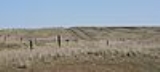
Parts of the Mullan Road can still be traveled. One such section is near Washtucna, Washington
.
A segment of the Mullan Road in the vicinity of Benton Lake was listed on the National Register of Historic Places
in 1975, and the American Society of Civil Engineers
designated it a historic civil engineering landmark in 1977. Three segments of the road in Idaho were also listed on the National Register in 1990. In 2009, the Point of Rocks segment in Montana was also listed on the National Register as part of the Point of Rocks Historic Transportation Corridor
.
to help settle the area with pioneers
and eliminate any claims that France
, England
or Russia
had on the disputed territories. Despite the Lewis and Clark expedition, little detail was known about the country. Isaac Ingalls Stevens, a West Point graduate appointed the first governor of the Washington Territory
, was ordered to survey
a route from the Missouri River
to the Columbia River
suitable for building a railroad. Stevens assumed the task, but also kept in mind that the route should be suitable for a wagon road.
In the spring of 1853, Congress authorized a US Army expedition
, led by Stevens. It was made up of engineers and explorers
; they organized near St. Paul, Minnesota. They were to detail the geographical and topographical character of the country. Among them was a small, dark-haired young man, Lieutenant John Mullan; just a year out of West Point, he was anxious to prove his mettle as an engineer.
Mullan was placed in charge of surveying, and later improving, a wagon route (now commonly called the Mullan Road) between Fort Benton
(Montana
) and Fort Walla Walla
(Washington). Lieutenant Mullan, a topographical engineer, began gathering information in 1854. Delayed by the Yakima War
which ended in 1858, construction began in 1859 from Fort Walla Walla
. In what was then Washington Territory
, Lieutenant Mullan commanded a workforce of more than 200, including civilian workers, surveyors
, engineers, and soldiers who carved a 25 feet (7.6 m) wide road across the region.
After the difficult project was completed in 1860, floods wiped out substantial stretches of the road. It was re-routed in 1861. Floods again damaged the road, and ultimately, no provision for maintenance was provided.
Although the road was never heavily used by the military, it was an important conduit for civilian passage, which hastened settling of the northwestern United States. In the first year after completion, it was used by an estimated 20,000 people, 6,000 horses and mules, 5,000 cattle and 83 wagons. The Mullan Road helped Walla Walla
become the largest town
in Washington Territory
by 1870, with a population of 1,394. The road continued to serve as an important route until the completion of the Northern Pacific Railroad in 1883 provided faster and more convenient access to the region.
Covered wagon
The covered wagon, also known as a Prairie schooner, is an icon of the American Old West.Although covered wagons were commonly used for shorter moves within the United States, in the mid-nineteenth century thousands of Americans took them across the Great Plains to Oregon and California...
road
Road
A road is a thoroughfare, route, or way on land between two places, which typically has been paved or otherwise improved to allow travel by some conveyance, including a horse, cart, or motor vehicle. Roads consist of one, or sometimes two, roadways each with one or more lanes and also any...
to cross the Rocky Mountains
Rocky Mountains
The Rocky Mountains are a major mountain range in western North America. The Rocky Mountains stretch more than from the northernmost part of British Columbia, in western Canada, to New Mexico, in the southwestern United States...
to the Inland
Inland Empire (Pacific Northwest)
thumb|The Inland Empire regionThe Inland Northwest, or Inland Empire, is a region in the Pacific Northwest centered on Spokane, Washington, including the surrounding Columbia River basin and all of North Idaho....
of the Pacific Northwest
Pacific Northwest
The Pacific Northwest is a region in northwestern North America, bounded by the Pacific Ocean to the west and, loosely, by the Rocky Mountains on the east. Definitions of the region vary and there is no commonly agreed upon boundary, even among Pacific Northwesterners. A common concept of the...
. It was built by US Army
United States Army
The United States Army is the main branch of the United States Armed Forces responsible for land-based military operations. It is the largest and oldest established branch of the U.S. military, and is one of seven U.S. uniformed services...
Lieut. John Mullan
John Mullan (road builder)
-Biography:Mullan was born in Norfolk, Virginia and graduated from West Point in 1852. He became a member of Isaac Stevens's party to explore the newly-created Washington Territory. Mullan was placed in charge of selecting a wagon route between Fort Benton and Fort Walla Walla...
between the spring of 1859 and summer 1860. It led from Fort Benton, Montana
Fort Benton, Montana
Fort Benton is a city in and the county seat of Chouteau County, Montana, United States. A portion of the city was designated as a National Historic Landmark District in 1961. Established a full generation beforethe U.S...
, the navigational head of the Missouri River (and once farthest inland port in the world) to Fort Walla Walla
Fort Walla Walla
Fort Walla Walla is a fort located in Walla Walla, Washington. It was established in 1858. Today, the complex contains a park, a museum, and a hospital.Fort Walla Walla should be distinguished from Fort Nez Percés or Old Fort Walla Walla ....
, Washington Territory
Washington Territory
The Territory of Washington was an organized incorporated territory of the United States that existed from February 8, 1853, until November 11, 1889, when the final extent of the territory was admitted to the Union as the State of Washington....
, near the Columbia River. The road previewed the route approximately followed of modern-day Interstate 15
Interstate 15
Interstate 15 is the fourth-longest north–south Interstate Highway in the United States, traveling through the states of California, Nevada, Arizona, Utah, Idaho, and Montana from San Diego to the Canadian border...
and Interstate 90
Interstate 90
Interstate 90 is the longest Interstate Highway in the United States at . It is the northernmost coast-to-coast interstate, and parallels US 20 for the most part. Its western terminus is in Seattle, at Edgar Martinez Drive S. near Safeco Field and CenturyLink Field, and its eastern terminus is in...
through what are now Montana, Idaho and Washington.
Parts of the Mullan Road can still be traveled. One such section is near Washtucna, Washington
Washtucna, Washington
Washtucna is a town in Adams County, Washington, United States. The population was 208 at the 2010 census, a 20% decrease over the previous census...
.
A segment of the Mullan Road in the vicinity of Benton Lake was listed on the National Register of Historic Places
National Register of Historic Places
The National Register of Historic Places is the United States government's official list of districts, sites, buildings, structures, and objects deemed worthy of preservation...
in 1975, and the American Society of Civil Engineers
American Society of Civil Engineers
The American Society of Civil Engineers is a professional body founded in 1852 to represent members of the civil engineering profession worldwide. It is the oldest national engineering society in the United States. ASCE's vision is to have engineers positioned as global leaders who strive toward...
designated it a historic civil engineering landmark in 1977. Three segments of the road in Idaho were also listed on the National Register in 1990. In 2009, the Point of Rocks segment in Montana was also listed on the National Register as part of the Point of Rocks Historic Transportation Corridor
Point of Rocks Historic Transportation Corridor
The Point of Rocks Historic Transportation Corridor in Mineral County, Montana is a historic district including portions of the historic Mullan Road and the Milwaukee Road Railroad....
.
History
As early as 1852 the US government began to think about building an overland route to the Pacific OceanPacific Ocean
The Pacific Ocean is the largest of the Earth's oceanic divisions. It extends from the Arctic in the north to the Southern Ocean in the south, bounded by Asia and Australia in the west, and the Americas in the east.At 165.2 million square kilometres in area, this largest division of the World...
to help settle the area with pioneers
American pioneer
American pioneers are any of the people in American history who migrated west to join in settling and developing new areas. The term especially refers to those who were going to settle any territory which had previously not been settled or developed by European or American society, although the...
and eliminate any claims that France
France
The French Republic , The French Republic , The French Republic , (commonly known as France , is a unitary semi-presidential republic in Western Europe with several overseas territories and islands located on other continents and in the Indian, Pacific, and Atlantic oceans. Metropolitan France...
, England
England
England is a country that is part of the United Kingdom. It shares land borders with Scotland to the north and Wales to the west; the Irish Sea is to the north west, the Celtic Sea to the south west, with the North Sea to the east and the English Channel to the south separating it from continental...
or Russia
Russia
Russia or , officially known as both Russia and the Russian Federation , is a country in northern Eurasia. It is a federal semi-presidential republic, comprising 83 federal subjects...
had on the disputed territories. Despite the Lewis and Clark expedition, little detail was known about the country. Isaac Ingalls Stevens, a West Point graduate appointed the first governor of the Washington Territory
Washington Territory
The Territory of Washington was an organized incorporated territory of the United States that existed from February 8, 1853, until November 11, 1889, when the final extent of the territory was admitted to the Union as the State of Washington....
, was ordered to survey
Surveying
See Also: Public Land Survey SystemSurveying or land surveying is the technique, profession, and science of accurately determining the terrestrial or three-dimensional position of points and the distances and angles between them...
a route from the Missouri River
Missouri River
The Missouri River flows through the central United States, and is a tributary of the Mississippi River. It is the longest river in North America and drains the third largest area, though only the thirteenth largest by discharge. The Missouri's watershed encompasses most of the American Great...
to the Columbia River
Columbia River
The Columbia River is the largest river in the Pacific Northwest region of North America. The river rises in the Rocky Mountains of British Columbia, Canada, flows northwest and then south into the U.S. state of Washington, then turns west to form most of the border between Washington and the state...
suitable for building a railroad. Stevens assumed the task, but also kept in mind that the route should be suitable for a wagon road.
In the spring of 1853, Congress authorized a US Army expedition
Exploration
Exploration is the act of searching or traveling around a terrain for the purpose of discovery of resources or information. Exploration occurs in all non-sessile animal species, including humans...
, led by Stevens. It was made up of engineers and explorers
Exploration
Exploration is the act of searching or traveling around a terrain for the purpose of discovery of resources or information. Exploration occurs in all non-sessile animal species, including humans...
; they organized near St. Paul, Minnesota. They were to detail the geographical and topographical character of the country. Among them was a small, dark-haired young man, Lieutenant John Mullan; just a year out of West Point, he was anxious to prove his mettle as an engineer.
Mullan was placed in charge of surveying, and later improving, a wagon route (now commonly called the Mullan Road) between Fort Benton
Fort Benton, Montana
Fort Benton is a city in and the county seat of Chouteau County, Montana, United States. A portion of the city was designated as a National Historic Landmark District in 1961. Established a full generation beforethe U.S...
(Montana
Montana
Montana is a state in the Western United States. The western third of Montana contains numerous mountain ranges. Smaller, "island ranges" are found in the central third of the state, for a total of 77 named ranges of the Rocky Mountains. This geographical fact is reflected in the state's name,...
) and Fort Walla Walla
Fort Walla Walla
Fort Walla Walla is a fort located in Walla Walla, Washington. It was established in 1858. Today, the complex contains a park, a museum, and a hospital.Fort Walla Walla should be distinguished from Fort Nez Percés or Old Fort Walla Walla ....
(Washington). Lieutenant Mullan, a topographical engineer, began gathering information in 1854. Delayed by the Yakima War
Yakima War
The Yakima War was a conflict between the United States and the Yakama, a Sahaptian-speaking people on the Northwest Plateau, then Washington Territory and now the southern interior of Eastern Washington, from 1855 to 1858.- Naming :...
which ended in 1858, construction began in 1859 from Fort Walla Walla
Fort Walla Walla
Fort Walla Walla is a fort located in Walla Walla, Washington. It was established in 1858. Today, the complex contains a park, a museum, and a hospital.Fort Walla Walla should be distinguished from Fort Nez Percés or Old Fort Walla Walla ....
. In what was then Washington Territory
Washington Territory
The Territory of Washington was an organized incorporated territory of the United States that existed from February 8, 1853, until November 11, 1889, when the final extent of the territory was admitted to the Union as the State of Washington....
, Lieutenant Mullan commanded a workforce of more than 200, including civilian workers, surveyors
Surveying
See Also: Public Land Survey SystemSurveying or land surveying is the technique, profession, and science of accurately determining the terrestrial or three-dimensional position of points and the distances and angles between them...
, engineers, and soldiers who carved a 25 feet (7.6 m) wide road across the region.
After the difficult project was completed in 1860, floods wiped out substantial stretches of the road. It was re-routed in 1861. Floods again damaged the road, and ultimately, no provision for maintenance was provided.
Although the road was never heavily used by the military, it was an important conduit for civilian passage, which hastened settling of the northwestern United States. In the first year after completion, it was used by an estimated 20,000 people, 6,000 horses and mules, 5,000 cattle and 83 wagons. The Mullan Road helped Walla Walla
Walla Walla, Washington
Walla Walla is the largest city in and the county seat of Walla Walla County, Washington, United States. The population was 31,731 at the 2010 census...
become the largest town
Town
A town is a human settlement larger than a village but smaller than a city. The size a settlement must be in order to be called a "town" varies considerably in different parts of the world, so that, for example, many American "small towns" seem to British people to be no more than villages, while...
in Washington Territory
Washington Territory
The Territory of Washington was an organized incorporated territory of the United States that existed from February 8, 1853, until November 11, 1889, when the final extent of the territory was admitted to the Union as the State of Washington....
by 1870, with a population of 1,394. The road continued to serve as an important route until the completion of the Northern Pacific Railroad in 1883 provided faster and more convenient access to the region.
Route of the Mullan Road
From the origin at Fort Benton, Montana, the Mullan Road proceeded:- West from Fort Benton, MontanaFort Benton, MontanaFort Benton is a city in and the county seat of Chouteau County, Montana, United States. A portion of the city was designated as a National Historic Landmark District in 1961. Established a full generation beforethe U.S...
- Passing North of Great Falls, MontanaGreat Falls, MontanaGreat Falls is a city in and the county seat of Cascade County, Montana, United States. The population was 58,505 at the 2010 census. It is the principal city of the Great Falls, Montana Metropolitan Statistical Area, which encompasses all of Cascade County...
- Dropping south to cross the continental divideContinental divideA continental divide is a drainage divide on a continent such that the drainage basin on one side of the divide feeds into one ocean or sea, and the basin on the other side either feeds into a different ocean or sea, or else is endorheic, not connected to the open sea...
west of Helena, MontanaHelena, MontanaHelena is the capital city of the U.S. state of Montana and the county seat of Lewis and Clark County. The 2010 census put the population at 28,180. The local daily newspaper is the Independent Record. The Helena Brewers minor league baseball and Helena Bighorns minor league hockey team call the...
(following a path through Mullan PassMullan PassThe Mullan Pass is a mountain pass in the Rocky Mountains of Montana in the United States. It sits on the continental divide on the border between Powell County, Montana and Lewis and Clark County, Montana, west of Helena, Montana in Helena National Forest at a height of .The Northern Pacific...
, immediately north of that now traveled by U.S. Route 12U.S. Route 12U.S. Route 12 or US 12 is an east–west United States highway, running from Grays Harbor on the Pacific Ocean, in the state of Washington, to downtown Detroit, for almost . As a thoroughfare, it has mostly been supplanted by I-90 and I-94, but remains an important road for local travel.The...
) - Along the Clark Fork River, near the ghost townGhost townA ghost town is an abandoned town or city. A town often becomes a ghost town because the economic activity that supported it has failed, or due to natural or human-caused disasters such as floods, government actions, uncontrolled lawlessness, war, or nuclear disasters...
of Bearmouth, MontanaBearmouth, MontanaBearmouth was a trading post for the placer mining camps of Beartown, Garnet and Coloma, located in the hills north of Bearmouth. A pioneer family named Lannen operated the gold exchange and ferry boat across the Clark Fork River.... - Just west of Garrison, MontanaGarrison, MontanaGarrison is a census-designated place in Powell County, Montana, United States. The population was 112 at the 2000 census.-Geography:Garrison is located at ....
, it joined the route of present-day Interstate 90Interstate 90Interstate 90 is the longest Interstate Highway in the United States at . It is the northernmost coast-to-coast interstate, and parallels US 20 for the most part. Its western terminus is in Seattle, at Edgar Martinez Drive S. near Safeco Field and CenturyLink Field, and its eastern terminus is in...
(similar to the U.S. Route 12 transition to join Interstate 90 today) - It remained with the Interstate 90Interstate 90Interstate 90 is the longest Interstate Highway in the United States at . It is the northernmost coast-to-coast interstate, and parallels US 20 for the most part. Its western terminus is in Seattle, at Edgar Martinez Drive S. near Safeco Field and CenturyLink Field, and its eastern terminus is in...
route as it passed MissoulaMissoula, MontanaMissoula is a city located in western Montana and is the county seat of Missoula County. The 2010 Census put the population of Missoula at 66,788 and the population of Missoula County at 109,299. Missoula is the principal city of the Missoula Metropolitan Area...
proceeding west through Montana. The Mullan Road through the Missoula Valley fostered rapid growth for the burgeoning city, and allowed the U.S. Army to establish Fort MissoulaFort MissoulaFort Missoula was established by the United States Army in 1877 on land that is now part of the city of Missoula, Montana, to protect white settlers in Western Montana from possible threats from the native American Indians, such as the Nez Perce....
there in 1877. - The road then crossed the border into IdahoIdahoIdaho is a state in the Rocky Mountain area of the United States. The state's largest city and capital is Boise. Residents are called "Idahoans". Idaho was admitted to the Union on July 3, 1890, as the 43rd state....
near Mullan, IdahoMullan, IdahoMullan is a city located in a sheltered canyon of the Coeur d'Alene Mountains in Shoshone County in the northern part of the U.S. state of Idaho. The population was 840 at the 2000 census and decreased to 692 at the 2010 census. The city is in the east end of the Silver Valley mining district; the...
(followed by the later Interstate 90). The highest elevation of the road is a second Mullan Pass at 5168 feet (1575 m), which lies about 7 miles (10 km) east of Mullan, Idaho on the Idaho-Montana border. - From the middle of the Idaho crossing, the road deviates from present-day major roads. The Mullan Road went southwesterly in Idaho to pass south of Lake Coeur d'AleneLake Coeur d'AleneLake Coeur d'Alene is a natural lake in the Idaho Panhandle, located in the vicinity of the city of the same name. It spans long, ranges from 1 to wide and has over of shoreline for boaters and vacationers to explore and enjoy.-Geology and geography:...
- The road then passed into Washington some distance south of Spokane, WashingtonSpokane, WashingtonSpokane is a city located in the Northwestern United States in the state of Washington. It is the largest city of Spokane County of which it is also the county seat, and the metropolitan center of the Inland Northwest region...
- From there, the Mullan Road passed through the PalousePalouseThe Palouse is a region of the northwestern United States, encompassing parts of southeastern Washington, north central Idaho and, in some definitions, extending south into northeast Oregon. It is a major agricultural area, primarily producing wheat and legumes...
country and then the scablands of eastern Washington. - It passed through Benge, WashingtonBenge, WashingtonBenge is an unincorporated community in Adams County, Washington, United States. Because it is not tracked by the U.S. Census, a Census population estimate is not available. Benge is assigned the ZIP code 99105...
. The Benge section of the road was completed May 22, 1861; the wagon ruts were still visible in 2008 just northeast of town at the site of the First Benge School. - South of Benge, there is a stretch of the former road still labeled 'Mullan Road'. This gravel section of the Mullan Road travels southwesterly until it meets Washington State Route 26Washington State Route 26State Route 26 is a state highway in the Grant, Adams, and Whitman counties, in the U.S. state of Washington. It extends from Interstate 90 east of the community of Vantage, east to U.S. Route 195 in Colfax. SR 26 intersects SR 24, SR 17, US 395, and SR 261 before...
near Washtucna, WashingtonWashtucna, WashingtonWashtucna is a town in Adams County, Washington, United States. The population was 208 at the 2010 census, a 20% decrease over the previous census...
. - The portion of Mullan Road south of SR 26 in Washington, which follows the course of the Palouse RiverPalouse RiverThe Palouse River is a tributary of the Snake River located in the U.S. states of Washington and Idaho. It flows for southwestwards, primarily through the Palouse region of southeastern Washington...
as it descends to the Snake RiverSnake RiverThe Snake is a major river of the greater Pacific Northwest in the United States. At long, it is the largest tributary of the Columbia River, the largest North American river that empties into the Pacific Ocean...
, has been reverted to grazing and is not accessible to the public. - After crossing the Snake River near the confluence with the Palouse River, the Mullan Road continues south to its terminus at Fort Walla WallaFort Walla WallaFort Walla Walla is a fort located in Walla Walla, Washington. It was established in 1858. Today, the complex contains a park, a museum, and a hospital.Fort Walla Walla should be distinguished from Fort Nez Percés or Old Fort Walla Walla ....
near Walla Walla, WashingtonWalla Walla, WashingtonWalla Walla is the largest city in and the county seat of Walla Walla County, Washington, United States. The population was 31,731 at the 2010 census...
.
External links
- Letter from the Secretary of War transmitting Lieut. Mullan's report, 1861
- Essay on Mullan Road at historylink.org, by Priscilla Long, February 16, 2003
- Blazing the Mullan Road by Mineral County, Montana
- Jon Axline, "Mullan's Point of Rocks", Montana: The Magazine of Western History (Montana Historical Society), Winter 1999
- "Who was Mullan? Answers are many", ruralnorthwest.com, originally in Coeur d'Alene Press, 1963
- The Mullan Road History of its Construction and Early Use J. William T. Youngs, Professor of History, Eastern Washington University