
Tornadoes of 2007
Encyclopedia
This page documents the tornado
es and tornado outbreak
s that occurred in 2007, primarily (but not entirely) in the United States. Most tornadoes form in the U.S., although some events may take place internationally, particularly in parts of neighboring southern Canada during the summer season. Some tornadoes also take place in Europe, e. g. in the United Kingdom or in Germany.
Preliminary reports suggest that there were 1,305 reported tornadoes in the U.S. (of which 1,093 were confirmed), with 81 confirmed fatalities. It was the deadliest year for tornadoes in the U.S. since 1999, when 95 deaths were reported. In addition, 3 fatalities took place in Mexico, 14 in Chad
, 1 in South Africa, 3 in Vietnam
, 1 in the Philippines
, 25 in China and 7 in Bangladesh
for a worldwide known total of at least 134.
Notably, the system for classifying tornado damage in the United States changed from the Fujita scale
to the Enhanced Fujita Scale
on February 1.
__FORCETOC__
The spring was also fairly active, with several significant tornado events in April and May, including a major outbreak in the first weekend of May producing the first ever EF5 tornado (and first F5 tornado on any scale in the 21st century). While June was not as active with fewer tornadoes, it produced another F5 tornado and Canada's first such confirmed tornado.
The tropics in the Western Hemisphere produced few significant tornadoes in 2007, but Typhoon Sepat
produced a deadly tornado in China. Otherwise, the summer and early fall were fairly quiet, with a few local exceptions. The most severe outbreak in the second half of the year took place in October, when the largest outbreak ever recorded in that month took place.
The year ended slowly with no major outbreaks in November or December and only a few isolated tornadoes, mostly related to larger winter storms.
, and 15 were injured. It was confirmed to have been an F1 as all the severe damage took place to mobile homes. At least four other tornadoes have been confirmed. One of them was an F2 tornado near Blackwater, Mississippi that injured nine people.
The activity continued farther east into Georgia
and the Carolinas on January 5, with at least one, and likely more, possible tornadoes. At least 15 people were injured in a tornado in Liberty, South Carolina
.
area in Coweta County
, Georgia
. One house was destroyed, but no one was injured by the F2 tornado. An F1 tornado was confirmed in Barbour County, Alabama
.
of severe winter storm "Kyrill" spawned tornadoes in Germany, three of which were confirmed as of February 22. The first one caused severe damage in the city of Lutherstadt Wittenberg, Saxony-Anhalt
. It hit at about 6:40 p.m. local time (1740 UTC). Roofs were blown away and trees virtually torn apart. It is estimated to have been an F2 to F3 tornado. Two more tornadoes were confirmed from Brandenburg
—one T6/F3 tracked through Brachwitz and Kemnitz, two small villages 60 kilometres (37.3 mi) southwest of Berlin. The strongest tornado that day, T7/F3, took place in Lauchhammer in southern Brandenburg
, which leveled massively built barns and snapped high tension poles. This twister tracked a distance of about 34 kilometres (21.1 mi).
More tornadoes were confirmed from Poland. In the late evening hours, a T3/F1 tornado struck a forest area near Silna in Lubuskie region (western Poland). Furthermore, two other tornadoes struck the village of Czermin near Wrocław and the small town of Andrespol near Lódz in central Poland. The confirmed intensity of the Andrespol-Tornado was T4/F2.
February 1, 2007 also marked the changeover to the Enhanced Fujita Scale
.
. The most severe damage occurred in Lake County
, where 21 people were killed. Two of the tornadoes were rated EF3 on the new Enhanced Fujita scale.
Damages from the tornadoes totaled to US$204 Million.
and Mississippi
. The most significant were around Lafayette, Louisiana
and in Greater New Orleans. Some of the tornadoes produced significant damage, including one in the Gentilly
neighborhood of New Orleans, Louisiana
which killed one woman and left dozens injured.
More tornadoes developed across Alabama
in the late afternoon on February 13 with several reports of damage across the state.
Damages from the tornadoes totaled to US$8.32 Million.
for both days over large areas.
 The activity on February 23 was quite modest due to a late start and low dew point
s. Six tornadoes were reported (and two were confirmed), and no significant damage was reported. The area primarily affected was the southern High Plains
.
At least 13 tornadoes were confirmed on February 24. The strongest tornado was reported in Dumas, Arkansas
, where buildings were destroyed or flattened, including an entire industrial park
. At least 40 people were injured, but, no one was killed. Extensive looting
was reported in the community after the tornado hit. The main employer in the town was also badly damaged by the EF3 tornado. Other tornadoes were recorded across Arkansas
, Mississippi
and Louisiana
, with the strongest being EF2.
Damages from the tornadoes totaled to US$48.41 Million.
 A large storm system spawned a significant tornado outbreak, which began February 28 in Kansas
and Missouri
and continued March 1 in Alabama
and Georgia
. On February 28, a moderate risk was issued for both days, and on March 1 a high risk was issued for western Alabama, eastern Mississippi
, the Florida Panhandle
and southern and central Georgia. It was the first such issuance since April 7, 2006.
On February 28, 12 tornadoes were reported, eight in Kansas
and four in Missouri
. One of them destroyed a house in Linn County, Kansas
and the tornado associated with this was rated EF4. Structural damage was also reported near Adrian, Missouri
, from a different tornado. Hail
as large as baseball
s were also reported.
As of March 1, there were at least 53 tornadoes reported that day. Significant damage was reported near Caulfield, Missouri
, and one person was killed in a mobile home
there. In the early afternoon, supercell
s became widespread across the region.
A tornado in Enterprise, Alabama
heavily damaged a high school and homes while killing nine people when the roof of the school collapsed. One other person was killed in Alabama as well as nine in Georgia including six in a single tornado in Baker County
. A total of 34 tornadoes were confirmed during the outbreak which killed 20. This outbreak was part of a large storm that produced a winter storm across the Midwest states, the Great Lakes
, Quebec
, Ontario
, the Canadian Maritimes and the US Northeast killing an additional 19 people.
Damages from the tornadoes totaled to greater than US$580 Million.
 A severe weather event developed on the afternoon of March 23 across West Texas
into the Texas Panhandle
and particularly across eastern New Mexico
. Several of the cells formed into tornadic supercells that evening, with at least 15 tornadoes reported and 11 tornadoes confirmed. A tornado rated EF2 hit Clovis, New Mexico
, with as many as 12 injured reported, and a tornado rated EF1 hit Logan, New Mexico
, where three people were injured and many campers and mobile homes were destroyed. In total, 16 people were injured, and two people died after the tornadoes.
Severe activity was not as widespread as expected on March 24. Four tornadoes were reported in northeastern Colorado
, one of which was reported to be a multiple vortex tornado
.
Several tornadoes associated with the same system continued on March 25, 26, and 27.
A slow-moving system developed across the High Plains
on the dry line
on March 28. A moderate risk of severe weather was issued by the Storm Prediction Center as widespread severe weather, including tornadoes, were expected throughout the afternoon and evening. In all, 65 tornadoes were reported in the region, with several destructive and large tornadoes taking place in numerous communities across the region. Many other severe weather reports came in, including hail
as large as softball
s. Five people lost their lives.
The system gradually moved east on March 29, but the squall line leftover from events the previous night prevented a major outbreak. Even so, four tornadoes were reported in Oklahoma
, two in the Oklahoma City
metropolitan area
, which injured several people.
The SPC had issued a moderate risk again for March 30 and March 31 over portions of southern Texas
. Few tornadoes were reported across the Midwest but one tornado hit midtown St. Louis
causing damage to roofs, trees and signs including parts of a billboard sign that flew over and blocked Interstate 64
.
. However, damaging hail and wind were the primary effects, although 10 tornadoes were reported in Texas
, Tennessee
, Kentucky
, Arkansas
and Alabama
. Nearly 400 reports of hail were reported throughout the day with the majority occurring during the afternoon hours in Missouri
, Illinois
, Arkansas and Kentucky
with also reports of golf ball to baseball size hail. The majority of the wind reports were from a bow echo
that developed across central Kentucky and Tennessee
during the evening hours and causing damage to trees, power lines, antennas and trailers. A total of 10 tornadoes were confirmed; all of them were EF0 or EF1. No fatalities were reported, but several people were injured.
Damages from the tornadoes totaled to US$2.73 Million.
(two EF0, one EF1 and one EF2 ) and 3 in Alabama
(all rated EF1). The system also created damaging winds and a great amount of hail.
issued a moderate risk of severe weather for April 13 over portions of North Central, Northeast Texas
, Southern Arkansas
and Northern Louisiana
. It was also issued for the central Gulf Coast for April 14. During the mid-afternoon hours, the moderate risk was upgraded to a high risk for the second time in 2007. In the Dallas-Fort Worth Metroplex, there have been a couple of unconfirmed tornadoes throughout the region. Hail as large as 3.25 inches (8.3 cm) and wind gusts up to 80 miles per hour (128.7 km/h) have been reported as well. One fatality has been reported although it may have been either from the tornado in Haltom City or from straight-line winds according to WFAA coverage. The tornadoes were reported in Seymour, Texas
and Haltom City, Texas
where one (or two) deaths has occurred. Two tornadoes of one EF0 and an EF1 tornado were later confirmed in Tarrant County
near Fort Worth
while another EF0 was confirmed in Dallas County
and a third EF0 in Rockwall County
. The severe weather caused cancellation of qualifying for the 2007 Samsung 500 at Texas Motor Speedway
, forcing the field to be established via owner's points. Nonetheless, the overall activity was much lower than expected and the high risk busted.
For April 14, the Storm Prediction Center issued a moderate risk of severe weather for southern Louisiana, Mississippi, Alabama
, Georgia
and northwestern Florida
. Several more scattered tornadoes were reported.
While most of the activity on April 15 was straight-line winds, an isolated EF3 tornado touched down in Sumter County, South Carolina that morning. Several mobile homes were demolished and one person was killed, with three injured. Two other tornadoes were later confirmed in South Carolina : an EF1 in Lee County and an EF0 in Orangeburg County. Several tornadoes also affected Georgia where at least 8 tornadoes and three injuries were documented.
. The system spawned ten tornadoes through northern Texas, such as Anton
, Lubbock
and Haslet
, which is only a few miles from where a number of tornadoes hit the Friday before, April 13, 2007. The system also created penny to ping-pong ball-sized hail and created dangerous wind speeds. Six tornadoes were confirmed, one EF1 and the others all EF0.
, all from a single supercell
that suddenly developed. Two have been confirmed as of April 23. A tornado near Moorefield, Nebraska
has been rated EF3. It destroyed six farmsteads and had a path length of 11 miles (17.7 km). Another EF2 tornado was confirmed in Dawson County, Nebraska
, which was over 1 miles (1.6 km) wide at its peak but fortunately remained in sparsely populated areas.
On April 20, the SPC issued a moderate risk of severe thunderstorms for the Texas
and Oklahoma
Panhandle
s and the southwestern part of Kansas
for April 21 which was extended into Nebraska
later. Widespread severe weather developed that evening, although the primary result of the supercells was large hail. The meteorological synopsis was virtually identical to March 28 except for the fact that the air mass was not as unstable. In total, 19 tornadoes were reported. The hardest hit community was Tulia, Texas
where many houses were reported to have been destroyed. That tornado was rated as a high-end EF2. Another strong tornado (also a high-end EF2) hit Cactus, Texas
where significant structural damage was reported (including total destruction to at least 10 mobile homes) and 14 people were injured, but remarkably, no one was killed. The tornado was 0.75 miles (1.2 km) wide at its widest point.
, Central Oklahoma
, and North Central Texas
. Such is an extremely rare issuance; only twice has such a risk been issued so far out—the others being for June 10, 2005 and January 2, 2006 (neither time did it result in a major outbreak).
Several tornadic storms were reported across northwest and south-central Texas, far western Oklahoma, and southwest Kansas on April 23. At least 29 tornadoes have been reported. Some were reported to have been large and powerful in the sparsely populated area. However, no injuries were reported.
The activity quickly redeveloped late in the morning of April 24. Later in the afternoon, the risk that day was upgraded to a high risk over parts of East Texas
. Tornadoes, along with large hail and damaging winds, occurred in the afternoon and evening hours across the Plains. 22 tornadoes were reported. One large tornadic supercell also moved through Piedras Negras, Coahuila
in Mexico, and moved into Eagle Pass, Texas
, with reports of significant damage on the U.S. side of the border and at least seven deaths and 74 injuries from that EF3 tornado, plus at least three deaths and at least 40 injuries across the river in Piedras Negras. There was virtually no activity in the high risk area, however, and that busted.
on the afternoon and evening of April 26. The hardest hit communities were LaPorte, Indiana
(by two EF1 tornadoes) and New Tazewell, Tennessee
(also by an EF1 tornado) where structural damage was reported in both communities, and dozens of houses were damaged or destroyed. Several other scattered tornadoes were reported, along with widespread wind damage. In total, seven people were injured. Four other tornadoes were confirmed in Ohio
and Illinois
.
and the other touched down in Virginia.
and one in New Mexico
.
(Tomskaya Oblast') in central-southern Siberia
. Some roofs were blown away and destroyed, windows were smashed and power lines as well as telephone lines were seriously damaged. An eyewitness reported that her child was whirled around as the tornado struck their street area. Fortunately, no one was seriously injured or killed. According to a damage report, this tornado was ranked as a F2.
 On the afternoon of May 2, supercells developed across several parts of Texas. 10 tornadoes were reported, including two in the city of El Paso
, however, the damage was relatively minor. Tornado watches were spread throughout Texas. However, the supercells redeveloped into a hybrid derecho
across Central and North Texas
that evening, stretching from the Dallas-Fort Worth Metroplex to south of Waco
and extending eastward to about Longview
. Widespread wind damage with winds in excess of 100 miles per hour (160.9 km/h) were reported. In the Metroplex, more than 300,000 customers lost power as a result of the high winds. Some of the most severe damage included the loss of a roof at an apartment complex, extensive tree and power line damage (with many trees crashing into houses) and flipped tractor-trailers and mobile homes. However, no fatalities were reported.
A significant severe weather event developed across the central Plains
on the evening of May 4. Early in the morning, The Storm Prediction Center issued a moderate risk of severe thunderstorms for May 4 over portions of Central Nebraska
, Western Kansas
, Western Oklahoma
, Eastern Colorado
and portions of the Texas
Panhandle
. Around 6:35 pm CDT (2335 UTC), a tornado was reported by KWTV
storm spotters on the ground near Arnett, Oklahoma
. The tornado stayed in mostly sparsely populated rural areas, but there were reports of a house 7 miles (11.3 km) west of Arnett being hit. At around 9:50 pm CDT (0250 UTC), there was a violent and destructive tornado in southwest Kansas
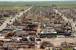
near Greensburg
. The tornado also moved into other communities including Trousdale
, Macksville
, Ellinwood
, Claflin
and Holyrood
which have taken direct hits from significant tornadoes. City administrator Steve Hewitt has said that 90% of Greensburg was destroyed and at least 16 people were critically injured, according to Fox
. Much of Macksville was also damaged or destroyed. 12 people died and 63 were injured according to the National Weather Service
and CNN
. The tornado was rated an EF5 on the Enhanced Fujita Scale, the first since the new scale was implemented and the first category 5 tornado since the Bridge Creek
tornado during the 1999 Oklahoma tornado outbreak on May 3, 1999. Another person was killed when a tornado destroyed structures in Ottawa County, Kansas
, and another died in Stafford County, Kansas
for an outbreak total of 14.
On the morning of May 5, the Storm Predicton Center issued a high risk across central Kansas and Nebraska. The Storm Prediction Center also issued a moderate risk for southern South Dakota and northwest Oklahoma and a slight risk for most of Oklahoma, northern South Dakota
, southern North Dakota
, eastern Nebraska
, western Iowa
and northeastern Colorado
.
There were 149 tornadoes reported across the area during the outbreak, including 7 on May 3 in Colorado and 30 on May 4. Three other tornadoes were reported in Illinois
from a different system. 102 tornadoes were reported on May 5, across the same areas except Illinois. Ten tornadoes were reported across Kansas, Oklahoma, and Texas on May 6. A tornado that was reported in Florida
was separate from the system in the plains and was not included in the count.
in Bihor
region in western Romania
, 40 km east of Oradea
. The tornado moved a truck, damaged roofs and snapped trees. This event was ranked as F1.
, Northern Ireland
(United Kingdom) resulting in roof damage and vehicle damage. There was 1 injury in the second tornado in 5 months to strike eastern Northern Ireland
. The tornado of Carrickfergus
was ranked as T2/F1 event.
destroying the town and killing 14 people.
and the other in Pennsylvania
.
and Kopciówka
near Suchowola
in Podlaskie (north-eastern Poland). The F1 tornado caused serious damage to roofs of houses and barns.
The second tornado struck the village of Opole Lubelskie
in Lubelskie (eastern Poland), destroying a circus tent. Up to 40 people were injured, most of them were children, who watched a circus show as the tornado struck the area.
Also on May 11, a tornado hit the areas of Dunboyne
and Ashbourne
in County Meath
(eastern Ireland) and caused light damage to roofs in this area.
s rolled through Southeast Michigan
and Southwestern Ontario
, causing one tornado touchdown near Bad Axe, Michigan, tracking towards Lake Huron
before dissipating. This tornado was detected by radar from numerous Flint and Detroit-area television stations' radar systems as upper level cyclonic rotation
. After crossing Lake Huron, the same system once again intensified and a strong F1 tornado touched down in a rural area north of Mitchell, Ontario
causing some damage There was also an EF0 tornado in northern Indiana
as well as in southern Ohio
.
as well as an EF0 in Illinois
.
Damages from the tornadoes totaled to US$50,000.
and another in Florida
.
.
and Nebraska
. None of them have been confirmed yet.
On May 22, the Storm Prediction Center issued a slight risk of severe weather for portions of South Dakota, Nebraska and Kansas. Environment Canada
also issued a slight risk of severe weather for northwestern Ontario
near the Minnesota
border. Eight tornadoes were reported in northwestern Kansas.
On the afternoon of May 22, the Storm Prediction Center issued a moderate risk of severe storms for parts of western Oklahoma
, southern Kansas
, and the northern Texas Panhandle
for May 23. Significant EF2-EF5 tornadoes were possible inside the moderate risk area. On May 23, 10 tornadoes were reported along with hail as large as softball
s.
.
early in the afternoon of June 1 and tracked into northwestern Illinois
and southwestern Wisconsin
. The hardest hit communities were Muscatine, Iowa
where widespread structural damage was reported, including businesses destroyed and injuries. Most of Grandview, Iowa
was sealed off due to the extensive damage it sustained from the tornado. Houses were flattened in Grandview and people were reported trapped by the EF3 tornado. A second nearby tornado, rated EF2, also left significant damage around Bellevue, Iowa
. No fatalities were reported.
 A low pressure system moved across much of central and eastern North America starting on June 6 in the central Plains and into the Mississippi Valley, Great Lakes
region and eventually the Northeast
over the following few days. On June 4, the Storm Prediction Center issued a moderate risk of severe weather for June 6, only the fourth such issuance for a day three outlook. On the morning of June 5, the Storm Prediction Center continued the moderate risk for June 6 and issued a moderate risk for June 7 over much of the Upper Midwest
, making it the fifth time a moderate risk has been issued on day 3. Both were forwarded to days 1 and 2, respectively, on June 6.
On June 6, there were two distinct threats forecast. The central Plains were expected to see a large tornado outbreak potentially, particularly in Nebraska
and the Dakotas close to the dry line
, should the cap have broken in the atmosphere in the afternoon hours. In the evening and overnight hours, a major derecho
with destructive winds and some scattered tornadoes were possible farther east, particularly in the eastern Dakotas, western Minnesota
and western Iowa
. However, that basically busted as little severe weather happened as the cap held up in most areas. Only five tornadoes and scattered wind reports took place.
A high risk of severe storms was issued for June 7 for the Upper Midwest, from about the Quad Cities
north to Lake Superior
. Widespread tornadoes and destructive downburst winds were possible. A moderate risk was issued for portions of Minnesota
, Michigan
and Illinois
while a slight risk was issued south towards Oklahoma
, which was then upgraded to a moderate risk late in the day. Environment Canada
also issued a risk of severe thunderstorms with possible tornadoes for all of northwestern Ontario
and a severe weather watch was issued early Thursday morning from the Manitoba
border towards the north shore of Lake Superior
There were 14 tornado reports that day. The most serious damage was near Mosinee, Wisconsin where a house was heavily damaged by an EF2 tornado, and in Wisconsin Rapids, Wisconsin
where a weak tornado touched down in or near the downtown area, along with softball
sized hail. However, farther south, the cap has held in place once again, restricting activity to the northern areas.
The largest confirmed tornado on June 7 was an EF3 that touched down in central Wisconsin. It was on the ground for 40 miles (64.4 km) while passing through Shawano
, Menominee, Langlade
, and Oconto counties
. It was up to 3/4 mi wide at times and took down 14,000 acres (57 km²) of forest, damaging dozens of buildings.
On June 8, Environment Canada
issued a moderate risk of severe thunderstorms for Eastern Ontario
with the risk of tornadoes. A Slight risk was issued for most of Southern
and Northeastern Ontario
. The slight risk zone extends from southern Quebec, near Montreal
into northern Mexico During the noon hours, the moderate risk zone was extended further south to includes portions of western New York
, western Pennsylvania
, northern West Virginia
, northern Kentucky
, southeastern Indiana
, most of Ohio
and larger portions of southern Ontario
from Windsor
to eastern Ontario
. It turned out to be a long squall line though, and while there was wind damage from winds as strong as 85 miles per hour (136.8 km/h) stretching from the Tennessee Valley
north to almost Hudson Bay
, there were only two tornadoes, one near Brantford
southwest of Toronto
and the other near Bancroft
north of Peterborough, Ontario
.
, northern Vietnam
, killing one person.
A supercell that developed over the Nebraska
/Kansas
border produced extensive hail and at least 7 reported tornadoes on June 19. The storm that travelled southeast through Oklahoma and North Texas eventually became an Mesoscale Convective Complex
dumping heavy rain across areas that had been hit with significant flooding.
A sharp cold front also produced widespread wind damage across the Great Lakes
and the Northeast and at least one reported tornado.
, killing two people and heavily damaging nearly 500 houses.
, it was an EF2 which heavily damaged homes.
 On June 22, more severe storms developed, this time primarily farther north. The most intense weather was across southern Manitoba
where tornadoes were reported. The most severe damage was around Elie, Manitoba
where several houses were flattened and numerous others damaged or destroyed. A flour
mill was also destroyed and several trucks were overturned on Highway 1
. The tornado path was 3.7 miles (6 km) long, and was initially rated as an F4 on the Fujita Scale
, but was then rated as an F5 becoming the first tornado of its kind in Canada. Another tornado hit McHenry County, North Dakota
; it was an EF1 with moderate damage, mainly to trees and farm buildings.
More tornadoes were possible across southeastern Saskatchewan
, southern Manitoba and extreme northern North Dakota
on June 23. The cap broke across the northern parts of the area and supercells formed that afternoon, primarily in Manitoba. At least five tornadoes were reported, including large wedge tornadoes. Fortunately, they missed populated areas for the most part. One of the tornadoes traveled 9 miles (14.5 km) south of Baldur, Manitoba
and was rated an F3 on the Fujita scale. The tornadoes were described as being "as bad as they ever get here in Canada" (referring to the F4 tornado) as meteorologist Dave Carlsen of Environment Canada
told Canwest Global affiliate CKND-TV
. However, the tornado in Elie
was recently upgraded to F5, after Environment Canada determined that wind speeds were at least 420 km/h in video analyses of that tornado.
in the north-west part of the province overturning boats, causing damage to trees and property as well as injuring one person.
were particularly hard hit by the storm. The tornado was extraordinarily long lived and destructive. It was estimated to have touched down around 2:50 pm local time and lifted around 6:00 pm local time, roughly 3 hours and 10 minutes in duration. Along the tornado's path 12,391 homes were destroyed and 3,180 were damaged. At least 30,000 people were affected by the tornado and damages were estimated at ¥
55 million (US$7.2 million). Local news reports referred to the tornado as the worst in nearly 50 years in China. The Chinese Government reported that the tornado packed winds of at least 100 km/h (60 mph), equivalent to an F1 tornado.
, where 10 tornadoes were confirmed including 9 EF0's and 1 EF1. 7 of the tornadoes occurred within 10 miles (16.1 km) of Seibert
.
. Six were reported in the city of New Plymouth
, Taranaki, devastating many houses and part of the Central Business District
. Whakatane
, Tauranga
, and Auckland
were also effected by tornadoes.
confirmed as an F1, destroys a large implementation shed. Debris reported 1.5 km away, 50 kg drums moved. Another tornado was sighted in the area but unconfirmed touchdown.
and one in South Dakota
. Among them were three EF2 tornadoes, which did significant damage to a number of farm properties across the region. Widespread straight-line wind damage was also reported in the area. However, no one was injured
. There was minor structural damage.
area of Northern Ireland
. This was the third tornado in the area in the last six months.
, Poland, causing damage to over 250 buildings, many with roofs blown out, some with brick walls partially collapsed.
at around 6:00 pm, where it eventually touched the ground. Minor EF0 damage was reported in the city, and the tornado's path was reportedly 1.1 miles (1.8 km) long.
 An unusual EF2
tornado struck New York City at 6:30 am EDT (1030 UTC) on August 8. The hardest-hit area was the Bay Ridge
area of Brooklyn
, where many trees—as much as 40% of the trees in Sunset Park
were knocked down and several homes and buildings lost part of their roofs. A second tornado was also confirmed just east of the track of the first tornado and rated as a strong EF1 where additional roofs of homes were damaged. The Flatbush
neighborhood, as well as areas on Staten Island
, were also affected.
Accompanying the tornadoes was a storm which dumped several inches of rain on the city in a few hours, resulting in flooding which effectively shut down the mass transit system. Several people were injured by the tornado, and one person died from the associated flooding. The tornado was the first to hit Brooklyn
since 1950 when modern record-keeping began.
, severe thunderstorms developed on the afternoon of August 9 in Ohio
and western Pennsylvania
. Several sudden supercells developed with at least four tornadoes reported, primarily around Akron, Ohio
. Significant damage was reported, including roofs removed from a high school
and a factory
, as well as numerous houses. Widespread straight-line wind damage was also reported. One person was killed by a fallen tree limb in Marion, Ohio
, although it is unclear if it is due to a tornado or straight-line winds. An EF1 tornado was confirmed in Medina County, Ohio. One tornado was also confirmed in Allegheny County, Pennsylvania
; the tornado was rated as a high-end EF0.
In Pittsburgh, a funnel cloud was spotted downtown near the Carnegie Science Center, shattering windows and evacuating the 1000 patrons to the lower level. The museum was closed until August 13. Over 90,000 homes and businesses were without power, some not receiving it until August 12.
around 5:21 pm EDT on August 23, after a hot muggy day caused convection east of an oncoming (eastbound) cold front. Another unconfirmed tornado was spotted tracking from Livonia, Michigan
to Redford Township, Michigan
.
It was part of a larger derecho
with winds up to 100 mph (160 km/h) that did significant damage in the Chicago area and in western Michigan. Embedded in the derecho was an EF1 tornado that touched down in Winfield, Illinois
in DuPage County
.
The National Weather Service office in Grand Rapids, Michigan
, confirmed that two EF1 tornadoes hit rural Montcalm County
near Cedar Lake. Non-tornadic severe thunderstorms also did serious damage in Berrien
, Van Buren
, Kalamazoo
, and Allegan
counties.
On August 24, following conditions similar to the previous day, an EF3 tornado with "winds near 140 mi/h" formed two miles (3 km) north of Charlotte, Michigan
, doing severe damage along Vermontville Highway, passing through Potterville
, and crossing I-69
in Eaton County
before dissipating as it approached Dimondale
, touching down around 4:25 pm EDT and leaving a damage path varying from 200 yards (182.9 m) to 300 yards (274.3 m) wide and 6.5 miles (10.5 km) long.
Around 4:55 pm EDT, the same storm produced an EF1 tornado which touched down at the intersection of Waverly Road and M-99 in southeastern Lansing
, extending across I-96, towards the intersections of Aurelius Road with Jolly Road and Dunkel Road before finally dissipating near the Jolly Road interchange on I-496.
Other storms in the same system later produced tornadoes in the NWS Detroit/Pontiac office coverage area. The most powerful one was a "strong EF2" that touched down in Cohoctah Township
, Livingston County, Michigan
at around 5:30 pm EDT. Remaining on the ground for 26 miles (41.8 km), with an average track width of 200 yards (182.9 m) and a maximum track width of one-quarter mile in the city of Fenton
, Genesee County
, the funnel continued through Deerfield Township
and northwestern Tyrone Township
before entering Genesee County
and the city of Fenton
, where it caused the partial collapse of "a large retail structure" at the intersection of Owen Road and US-23. It then passed on into Holly
, in Oakland County
before dissipating into straight-line winds east of Holly.
Three other tornadoes were confirmed by damage surveys. An EF0 tornado touched down briefly (track length 50 yards) near the intersection of Durand Road and M-21 in eastern Shiawassee County, Michigan
at around 5:23 pm EDT, while another EF0 tornado touched down for three miles (5 km) in Salem Township
, Washtenaw County
at around 6:02 pm EDT. Additionally, an EF1 tornado struck in Hadley Township
, Lapeer County
, at around 6:16 pm EDT, leaving a four mile (6 km) long damage path. Numerous reports of straight-line wind damage were also received throughout the entire NWS Detroit/Pontiac coverage area.
The storms in this system were part of the same system that sat over the Midwest Areas for almost a week, bringing pouring rain at first then the Severe Weather later in the week. This storm system and stationary front is also blamed for the flooding in the Ohio area.
, Bogotá
, and was caught on tape. There were no immediate word on any damage or injuries. Much of western Colombia lies along the Andes
mountain chain which limits tornado activity in that region. However, in June 2001 a tornado killed six people and injured 350 in the town of Barranquillia in extreme northern Colombia.
 An isolated tornado event produced at least four tornadoes in eastern North Dakota
and northwestern Minnesota
on the evening of August 26, 2007. One of the tornadoes was very destructive and did widespread damage in Northwood, North Dakota
. One fatality occurred in Northwood and multiple structures were damaged or destroyed including a mobile home
park and the community's hospital, school, and fire hall. This was the first killer U.S. tornado since May 5, 2007. 18 other people were injured by the tornado, which was about 0.8 mile (1.3 km) wide. Surveys confirmed it to be an EF4 tornado; the fifth violent US tornado of 2007.
which made landfill west of the Texas
/Louisiana
border on September 13 produced several clusters of thunderstorms, which spawned at least eight confirmed tornadoes (and several more unconfirmed reports) across portions of North Carolina
, along with widespread straight-line wind damage. In Clemmons
one tornado damaged several homes, while another tornado significantly damaged a nursing home in Fuquay-Varina
forcing the evacuation due to a fire in an electrical boxes. Counties affected included Wake
, Johnston
and Harnett
. There were no injuries from any of the tornadoes. Seven of the tornadoes were EF0, and the other was EF1.
(which later became Tropical Depression Ten
) spawned one confirmed and several possible tornadoes late on September 20 and early on September 21 over parts of central Florida
, not far from areas devastated on February 2. The hardest-hit community was Eustis, Florida
where at least 50 houses were damaged, many of which were destroyed. Looting
was reported in the community after the tornado hit. No serious injuries were reported by the EF1 tornado.
, which was 22 miles (35 km) long and up to 0.7 mile (1.1 km) wide at its peak. Heavy damage was reported to several houses and industrial buildings from the largest of the tornadoes. Several injuries were reported in Pike County, Illinois
due to mobile home
damage from an EF0 tornado there.
One of the more notable tornadoes hit the downtown
core of Des Moines, Iowa
. It was an EF1 that produced only minor damage along most of its path, with the most serious damage being flipped vehicles along Mulberry Street.
of northern Bangladesh
, injuring 25 people. Another tornado also struck north-central Jamalpur District
, damaging 500 homes and 200 hectares (2 km²) of sugarcane
.
, Gopalganj
and Bhola District
districts of southern Bangladesh, killing seven people and leaving 3,000 people homeless.
 A complex storm system, involving a deepening low pressure area
(979 mb ), a tropical low and a series of fronts, developed across the central United States
. The SPC forecast a potential severe weather event, possibly a major outbreak, beginning October 17 across much of central and eastern North America.
A moderate risk of severe storms was issued for October 17 across parts of the central U.S. Some activity developed early in the morning of October 17, although no tornadoes were reported. The main supercell activity began that afternoon across a wide swath from Missouri
south to Louisiana
and west to Oklahoma
. At least 16 tornadoes were reported and seven confirmed, with damage in Franklinton, Louisiana
and Mount Vernon, Missouri
(an EF2). In addition, KTUL
has reported at least 40 people were injured in Tulsa
at Oktoberfest
when thunderstorm winds ripped through the area. The activity turned deadly overnight as an isolated tornado developed in the overnight hours near Paris, Missouri
. At least two people were killed when a tornado hit a mobile home.
More severe weather is expected on October 18 across the Ohio Valley and the Great Lakes
region. Another moderate risk has been issued with tornadoes the main threat. Tornadoes are also possible across the Southern US
, particularly the Gulf Coast
. The activity began quickly in the southern threat area, and an EF1 tornado took place in the downtown area of Pensacola, Florida
. Damage was reported to many buildings in the downtown core, as well as a section of Cordova Mall
. Electricity
was cut in the area. No injuries were reported. In total, at least 30 tornadoes have been reported so far on October 18 and at least 18 have been confirmed. The hardest-hit state has been Kentucky
, where many tornadic supercells formed between Paducah
and Louisville
, and WFIE
has reported many injuries and possible fatalities in numerous communities. At least one person was confirmed dead in Owensboro, Kentucky
. However, the National Weather Service
has only confirmed minor injuries. Another major tornado has been reported near Nappanee, Indiana
; a tornado emergency was declared there. One person was confirmed dead in Kalkaska, Michigan
, following an EF2 tornado there while two other people were killed in Ingham County
in the Lansing
viewing area by an EF2 that caused extensive damage in the Williamston
area. While early indications had severe weather continuing into October 19, the lack of sunshine prevented initiation even though temperatures in the 80s Fahrenheit
were common as far north as southeastern Ontario and southwestern Quebec.
, New South Wales
, Australia. The tornado developed from a supercell at approximately 4pm damaging a power sub-station then going on to Dunoon where it ripped the wall of a church and damaged the roofs and walls of about 20 houses. The tornado was captured on film by both a local and Australian stormchaser Jimmy Deguara and estimated to be at least an EF1 in strength. and
n capital Bogotá
was hit by its second tornado of the year. The cyclone which was also caught on tape, tore up the roof of a car dealership and additional scattered damage. No injuries or deaths were reported during the tornado event. The area was hit with extensive severe weather over the past few days which included torrential rains that caused significant flooding across the region as well as hail and wind. Hundreds of motorists were stranding on area roads due to the extensive amounts of hail and rain.
 After a lull in activity in the US, several tornadoes touched down across parts of the Tennessee Valley
north into Kentucky
on November 14. The strongest was an EF2 in Kimball, Tennessee
where several houses and a church were heavily damaged, injuring nine people. Structural damage was also reported in Laurel County, Kentucky
and in two counties in Middle Tennessee
from separate EF1 tornadoes.
After a lull in activity in the US, several tornadoes touched down across parts of the Tennessee Valley
north into Kentucky
on November 14. The strongest was an EF2 in Kimball, Tennessee
where several houses and a church were heavily damaged, injuring nine people. Structural damage was also reported in Laurel County, Kentucky
and in two counties in Middle Tennessee
from separate EF1 tornadoes.
 A complex weather system developed in mid-December, involving the merging of the remnants of Tropical Storm Olga
with a cold front
associated with a major winter storm to the north over the Northeast
and Midwest
. As a result, the first severe weather episode in more than a month in the US produced several tornadoes across the Deep South
, particularly southern Georgia
and northern and central Florida
, late on December 15 and early on December 16. At least 12 tornadoes were reported across the region, with significant damage in several communities. In addition, straight line wind damage has also been reported across the region. One of the more notable tornadoes, an EF1, hit the Pasco County
Jail
, causing significant damage to the facility. No one was injured there. The strongest tornado was an EF2 near Lothair, Georgia
.
One person was killed near Ashburn, Georgia
, when his eighteen-wheeler was thrown off Interstate 75
by an EF1 tornado.
late in the evening on December 19, with wind and hail damage reported in eastern Texas
, Louisiana
, Mississippi
, and Alabama
. On December 20 a tornado formed near Brookhaven, Mississippi
, damaging several buildings and destroying two mobile homes. One person was injured. The tornado was rated EF2.
Tornado
A tornado is a violent, dangerous, rotating column of air that is in contact with both the surface of the earth and a cumulonimbus cloud or, in rare cases, the base of a cumulus cloud. They are often referred to as a twister or a cyclone, although the word cyclone is used in meteorology in a wider...
es and tornado outbreak
Tornado outbreak
While there is no single agreed upon definition, generally at least 6-10 tornadoes produced by the same synoptic scale weather system is considered a tornado outbreak. The tornadoes usually occur within the same day, or continue into the early morning hours of the succeeding day, and within the...
s that occurred in 2007, primarily (but not entirely) in the United States. Most tornadoes form in the U.S., although some events may take place internationally, particularly in parts of neighboring southern Canada during the summer season. Some tornadoes also take place in Europe, e. g. in the United Kingdom or in Germany.
Preliminary reports suggest that there were 1,305 reported tornadoes in the U.S. (of which 1,093 were confirmed), with 81 confirmed fatalities. It was the deadliest year for tornadoes in the U.S. since 1999, when 95 deaths were reported. In addition, 3 fatalities took place in Mexico, 14 in Chad
Chad
Chad , officially known as the Republic of Chad, is a landlocked country in Central Africa. It is bordered by Libya to the north, Sudan to the east, the Central African Republic to the south, Cameroon and Nigeria to the southwest, and Niger to the west...
, 1 in South Africa, 3 in Vietnam
Vietnam
Vietnam – sometimes spelled Viet Nam , officially the Socialist Republic of Vietnam – is the easternmost country on the Indochina Peninsula in Southeast Asia. It is bordered by China to the north, Laos to the northwest, Cambodia to the southwest, and the South China Sea –...
, 1 in the Philippines
Philippines
The Philippines , officially known as the Republic of the Philippines , is a country in Southeast Asia in the western Pacific Ocean. To its north across the Luzon Strait lies Taiwan. West across the South China Sea sits Vietnam...
, 25 in China and 7 in Bangladesh
Bangladesh
Bangladesh , officially the People's Republic of Bangladesh is a sovereign state located in South Asia. It is bordered by India on all sides except for a small border with Burma to the far southeast and by the Bay of Bengal to the south...
for a worldwide known total of at least 134.
Notably, the system for classifying tornado damage in the United States changed from the Fujita scale
Fujita scale
The Fujita scale , or Fujita-Pearson scale, is a scale for rating tornado intensity, based primarily on the damage tornadoes inflict on human-built structures and vegetation...
to the Enhanced Fujita Scale
Enhanced Fujita Scale
The Enhanced Fujita Scale rates the strength of tornadoes in the United States based on the damage they cause.Implemented in place of the Fujita scale introduced in 1971 by Ted Fujita, it began operational use on February 1, 2007. The scale has the same basic design as the original Fujita scale:...
on February 1.
__FORCETOC__
Synopsis
2007 started quickly in terms of tornadoes, with the first tornado fatalities taking place in the first week of January. After few other significant events in the rest of January, a deadly period took place in the latter part of the winter. Two deadly outbreaks and several other major tornado events marred February and March, especially in the southern US.The spring was also fairly active, with several significant tornado events in April and May, including a major outbreak in the first weekend of May producing the first ever EF5 tornado (and first F5 tornado on any scale in the 21st century). While June was not as active with fewer tornadoes, it produced another F5 tornado and Canada's first such confirmed tornado.
The tropics in the Western Hemisphere produced few significant tornadoes in 2007, but Typhoon Sepat
Typhoon Sepat (2007)
Typhoon Sepat was the eighth tropical storm of the 2007 Pacific typhoon season that affected the Philippines and made landfall in Taiwan and Fujian.-Meteorological history:On August 11, a low-level circulation center...
produced a deadly tornado in China. Otherwise, the summer and early fall were fairly quiet, with a few local exceptions. The most severe outbreak in the second half of the year took place in October, when the largest outbreak ever recorded in that month took place.
The year ended slowly with no major outbreaks in November or December and only a few isolated tornadoes, mostly related to larger winter storms.
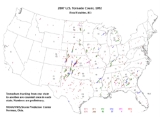
Events
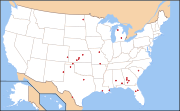
Confirmed tornado total for the entire year 2007 in the United States. January tornadoes were rated using the old Fujita scale, but are included in the chart below using the EF scale keeping their intensity number.January 4–5
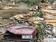
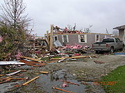
The first severe weather event of 2007 was a scattered but deadly tornado event in the U.S. Gulf Coast region on January 4. Two people were killed in New Iberia, LouisianaNew Iberia, Louisiana
New Iberia is a city in and the parish seat of Iberia Parish, Louisiana, United States, 30 miles southeast of Lafayette. In 1900, 6,815 people lived in New Iberia; in 1910, 7,499; and in 1940, 13,747...
, and 15 were injured. It was confirmed to have been an F1 as all the severe damage took place to mobile homes. At least four other tornadoes have been confirmed. One of them was an F2 tornado near Blackwater, Mississippi that injured nine people.
The activity continued farther east into Georgia
Georgia (U.S. state)
Georgia is a state located in the southeastern United States. It was established in 1732, the last of the original Thirteen Colonies. The state is named after King George II of Great Britain. Georgia was the fourth state to ratify the United States Constitution, on January 2, 1788...
and the Carolinas on January 5, with at least one, and likely more, possible tornadoes. At least 15 people were injured in a tornado in Liberty, South Carolina
Liberty, South Carolina
Liberty is a city in Pickens County, South Carolina, United States. It is part of the Greenville–Mauldin–Easley Metropolitan Statistical Area...
.
January 7
More severe weather developed in the South on January 7. The worst damage from tornadoes took place in the Lake BlalockLake Blalock
Lake Blalock is a reservoir in Spartanburg County, South Carolina, located on the Pacolet River about five miles north of Spartanburg. After its creation was authorized in 1976 by the Commissioners of Spartanburg Water System, Blalock Dam was constructed in 1983. The existing earthen dam is...
area in Coweta County
Coweta County, Georgia
Coweta County is a county located in the U.S. state of Georgia. As of 2000, the population was 89,215. The 2009 Census Estimate placed the population at 131,936...
, Georgia
Georgia (U.S. state)
Georgia is a state located in the southeastern United States. It was established in 1732, the last of the original Thirteen Colonies. The state is named after King George II of Great Britain. Georgia was the fourth state to ratify the United States Constitution, on January 2, 1788...
. One house was destroyed, but no one was injured by the F2 tornado. An F1 tornado was confirmed in Barbour County, Alabama
Barbour County, Alabama
Barbour County, Alabama is a county of the U.S. state of Alabama. Its name is in honor of James Barbour, who served as Governor of Virginia. As of 2010 the population was 27,457. Its county seat is Clayton.-History:...
.
January 18 (Europe)
The cold frontCold front
A cold front is defined as the leading edge of a cooler mass of air, replacing a warmer mass of air.-Development of cold front:The cooler and denser air wedges under the less-dense warmer air, lifting it...
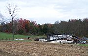
of severe winter storm "Kyrill" spawned tornadoes in Germany, three of which were confirmed as of February 22. The first one caused severe damage in the city of Lutherstadt Wittenberg, Saxony-Anhalt
Saxony-Anhalt
Saxony-Anhalt is a landlocked state of Germany. Its capital is Magdeburg and it is surrounded by the German states of Lower Saxony, Brandenburg, Saxony, and Thuringia.Saxony-Anhalt covers an area of...
. It hit at about 6:40 p.m. local time (1740 UTC). Roofs were blown away and trees virtually torn apart. It is estimated to have been an F2 to F3 tornado. Two more tornadoes were confirmed from Brandenburg
Brandenburg
Brandenburg is one of the sixteen federal-states of Germany. It lies in the east of the country and is one of the new federal states that were re-created in 1990 upon the reunification of the former West Germany and East Germany. The capital is Potsdam...
—one T6/F3 tracked through Brachwitz and Kemnitz, two small villages 60 kilometres (37.3 mi) southwest of Berlin. The strongest tornado that day, T7/F3, took place in Lauchhammer in southern Brandenburg
Brandenburg
Brandenburg is one of the sixteen federal-states of Germany. It lies in the east of the country and is one of the new federal states that were re-created in 1990 upon the reunification of the former West Germany and East Germany. The capital is Potsdam...
, which leveled massively built barns and snapped high tension poles. This twister tracked a distance of about 34 kilometres (21.1 mi).
More tornadoes were confirmed from Poland. In the late evening hours, a T3/F1 tornado struck a forest area near Silna in Lubuskie region (western Poland). Furthermore, two other tornadoes struck the village of Czermin near Wrocław and the small town of Andrespol near Lódz in central Poland. The confirmed intensity of the Andrespol-Tornado was T4/F2.
February
87 tornadoes were reported in the US in February, of which 54 were confirmed.February 1, 2007 also marked the changeover to the Enhanced Fujita Scale
Enhanced Fujita Scale
The Enhanced Fujita Scale rates the strength of tornadoes in the United States based on the damage they cause.Implemented in place of the Fujita scale introduced in 1971 by Ted Fujita, it began operational use on February 1, 2007. The scale has the same basic design as the original Fujita scale:...
.
February 2
In the early morning hours of February 2, four separate tornadoes ran across Central FloridaCentral Florida
Central Florida is a regional designation for the area surrounding Orlando in east central Florida, United States. The area represents the third largest population concentration in Florida, after the South Florida and Tampa Bay regions, respectively....
. The most severe damage occurred in Lake County
Lake County, Florida
Lake County is a county located in the state of Florida, United States. As of the 2000 Census, the population was 210,528. The Census Bureau estimated the population in 2008 to be 307,243. Its county seat is Tavares...
, where 21 people were killed. Two of the tornadoes were rated EF3 on the new Enhanced Fujita scale.
Damages from the tornadoes totaled to US$204 Million.
February 12–13
Beginning in the late evening hours of February 12 and overnight into February 13, 17 tornadoes touched down across southern LouisianaLouisiana
Louisiana is a state located in the southern region of the United States of America. Its capital is Baton Rouge and largest city is New Orleans. Louisiana is the only state in the U.S. with political subdivisions termed parishes, which are local governments equivalent to counties...
and Mississippi
Mississippi
Mississippi is a U.S. state located in the Southern United States. Jackson is the state capital and largest city. The name of the state derives from the Mississippi River, which flows along its western boundary, whose name comes from the Ojibwe word misi-ziibi...
. The most significant were around Lafayette, Louisiana
Lafayette, Louisiana
Lafayette is a city in and the parish seat of Lafayette Parish, Louisiana, United States, on the Vermilion River. The population was 120,623 at the 2010 census...
and in Greater New Orleans. Some of the tornadoes produced significant damage, including one in the Gentilly
Gentilly
Gentilly may refer to:France* Gentilly, Val-de-Marne, a commune of the Val-de-Marne départementCanada* Gentilly, Quebec, a suburb of the city of Bécancour** Gentilly Nuclear Generating StationUnited States...
neighborhood of New Orleans, Louisiana
New Orleans, Louisiana
New Orleans is a major United States port and the largest city and metropolitan area in the state of Louisiana. The New Orleans metropolitan area has a population of 1,235,650 as of 2009, the 46th largest in the USA. The New Orleans – Metairie – Bogalusa combined statistical area has a population...
which killed one woman and left dozens injured.
More tornadoes developed across Alabama
Alabama
Alabama is a state located in the southeastern region of the United States. It is bordered by Tennessee to the north, Georgia to the east, Florida and the Gulf of Mexico to the south, and Mississippi to the west. Alabama ranks 30th in total land area and ranks second in the size of its inland...
in the late afternoon on February 13 with several reports of damage across the state.
Damages from the tornadoes totaled to US$8.32 Million.
February 23–24
A moderate severe weather event took place on February 23 and 24 across the south-central United States. It was expected to have been much larger, on February 23, as a moderate risk of severe weather was issued by the Storm Prediction CenterStorm Prediction Center
The Storm Prediction Center , located in Norman, Oklahoma, is tasked with forecasting the risk of severe thunderstorms and tornadoes in the contiguous United States. The agency issues convective outlooks, mesoscale discussions, and watches as a part of this process...
for both days over large areas.
Dew point
The dew point is the temperature to which a given parcel of humid air must be cooled, at constant barometric pressure, for water vapor to condense into liquid water. The condensed water is called dew when it forms on a solid surface. The dew point is a saturation temperature.The dew point is...
s. Six tornadoes were reported (and two were confirmed), and no significant damage was reported. The area primarily affected was the southern High Plains
High Plains
High Plains refers to one of two distinct land regions:*High Plains , land region of the western Great Plains*High Plains , land region adjacent to the Great Dividing Range...
.
At least 13 tornadoes were confirmed on February 24. The strongest tornado was reported in Dumas, Arkansas
Dumas, Arkansas
Dumas is a city in Desha County, Arkansas, United States. The population was 4,706 at the 2010 census.-Geography:Dumas is located at .According to the United States Census Bureau, the city has a total area of , all land....
, where buildings were destroyed or flattened, including an entire industrial park
Industrial park
An industrial park is an area zoned and planned for the purpose of industrial development...
. At least 40 people were injured, but, no one was killed. Extensive looting
Looting
Looting —also referred to as sacking, plundering, despoiling, despoliation, and pillaging—is the indiscriminate taking of goods by force as part of a military or political victory, or during a catastrophe, such as during war, natural disaster, or rioting...
was reported in the community after the tornado hit. The main employer in the town was also badly damaged by the EF3 tornado. Other tornadoes were recorded across Arkansas
Arkansas
Arkansas is a state located in the southern region of the United States. Its name is an Algonquian name of the Quapaw Indians. Arkansas shares borders with six states , and its eastern border is largely defined by the Mississippi River...
, Mississippi
Mississippi
Mississippi is a U.S. state located in the Southern United States. Jackson is the state capital and largest city. The name of the state derives from the Mississippi River, which flows along its western boundary, whose name comes from the Ojibwe word misi-ziibi...
and Louisiana
Louisiana
Louisiana is a state located in the southern region of the United States of America. Its capital is Baton Rouge and largest city is New Orleans. Louisiana is the only state in the U.S. with political subdivisions termed parishes, which are local governments equivalent to counties...
, with the strongest being EF2.
Damages from the tornadoes totaled to US$48.41 Million.
February 28–March 2
Kansas
Kansas is a US state located in the Midwestern United States. It is named after the Kansas River which flows through it, which in turn was named after the Kansa Native American tribe, which inhabited the area. The tribe's name is often said to mean "people of the wind" or "people of the south...
and Missouri
Missouri
Missouri is a US state located in the Midwestern United States, bordered by Iowa, Illinois, Kentucky, Tennessee, Arkansas, Oklahoma, Kansas and Nebraska. With a 2010 population of 5,988,927, Missouri is the 18th most populous state in the nation and the fifth most populous in the Midwest. It...
and continued March 1 in Alabama
Alabama
Alabama is a state located in the southeastern region of the United States. It is bordered by Tennessee to the north, Georgia to the east, Florida and the Gulf of Mexico to the south, and Mississippi to the west. Alabama ranks 30th in total land area and ranks second in the size of its inland...
and Georgia
Georgia (U.S. state)
Georgia is a state located in the southeastern United States. It was established in 1732, the last of the original Thirteen Colonies. The state is named after King George II of Great Britain. Georgia was the fourth state to ratify the United States Constitution, on January 2, 1788...
. On February 28, a moderate risk was issued for both days, and on March 1 a high risk was issued for western Alabama, eastern Mississippi
Mississippi
Mississippi is a U.S. state located in the Southern United States. Jackson is the state capital and largest city. The name of the state derives from the Mississippi River, which flows along its western boundary, whose name comes from the Ojibwe word misi-ziibi...
, the Florida Panhandle
Florida Panhandle
The Florida Panhandle, an informal, unofficial term for the northwestern part of Florida, is a strip of land roughly 200 miles long and 50 to 100 miles wide , lying between Alabama on the north and the west, Georgia also on the north, and the Gulf of Mexico to the south. Its eastern boundary is...
and southern and central Georgia. It was the first such issuance since April 7, 2006.
On February 28, 12 tornadoes were reported, eight in Kansas
Kansas
Kansas is a US state located in the Midwestern United States. It is named after the Kansas River which flows through it, which in turn was named after the Kansa Native American tribe, which inhabited the area. The tribe's name is often said to mean "people of the wind" or "people of the south...
and four in Missouri
Missouri
Missouri is a US state located in the Midwestern United States, bordered by Iowa, Illinois, Kentucky, Tennessee, Arkansas, Oklahoma, Kansas and Nebraska. With a 2010 population of 5,988,927, Missouri is the 18th most populous state in the nation and the fifth most populous in the Midwest. It...
. One of them destroyed a house in Linn County, Kansas
Linn County, Kansas
Linn County is a county located in East Central Kansas, in the Central United States. As of the 2010 census, the county population was 9,656. Its county seat is Mound City, and its most populous city is Pleasanton...
and the tornado associated with this was rated EF4. Structural damage was also reported near Adrian, Missouri
Adrian, Missouri
Adrian is a city in Bates County, Missouri, United States. The population was 1,780 at the 2000 census.-Geography:Adrian is located at ....
, from a different tornado. Hail
Hail
Hail is a form of solid precipitation. It consists of balls or irregular lumps of ice, each of which is referred to as a hail stone. Hail stones on Earth consist mostly of water ice and measure between and in diameter, with the larger stones coming from severe thunderstorms...
as large as baseball
Baseball
Baseball is a bat-and-ball sport played between two teams of nine players each. The aim is to score runs by hitting a thrown ball with a bat and touching a series of four bases arranged at the corners of a ninety-foot diamond...
s were also reported.
As of March 1, there were at least 53 tornadoes reported that day. Significant damage was reported near Caulfield, Missouri
Caulfield, Missouri
Caulfield is an unincorporated community in western Howell County, Missouri, United States. It is located on U.S. Highway 160 about fifteen miles west of West Plains. The community was founded in 1930 and is named after Missouri governor Henry Stewart Caulfield, who took office in 1929.On March...
, and one person was killed in a mobile home
Mobile home
Mobile homes or static caravans are prefabricated homes built in factories, rather than on site, and then taken to the place where they will be occupied...
there. In the early afternoon, supercell
Supercell
A supercell is a thunderstorm that is characterized by the presence of a mesocyclone: a deep, continuously-rotating updraft. For this reason, these storms are sometimes referred to as rotating thunderstorms...
s became widespread across the region.
A tornado in Enterprise, Alabama
Enterprise, Alabama
Enterprise is a city in the southeastern part of Coffee and Dale Counties in the southeastern part of Alabama in the Southern United States. The population was estimated to be 25,909 in the year 2009....
heavily damaged a high school and homes while killing nine people when the roof of the school collapsed. One other person was killed in Alabama as well as nine in Georgia including six in a single tornado in Baker County
Baker County, Georgia
Baker County is a county in the U.S. state of Georgia. , the population is 4,074. The 2007 Census Estimate placed the population at 3,781. The county seat is Newton.Baker County is included in the Albany, Georgia Metropolitan Statistical Area.-History:...
. A total of 34 tornadoes were confirmed during the outbreak which killed 20. This outbreak was part of a large storm that produced a winter storm across the Midwest states, the Great Lakes
Great Lakes
The Great Lakes are a collection of freshwater lakes located in northeastern North America, on the Canada – United States border. Consisting of Lakes Superior, Michigan, Huron, Erie, and Ontario, they form the largest group of freshwater lakes on Earth by total surface, coming in second by volume...
, Quebec
Quebec
Quebec or is a province in east-central Canada. It is the only Canadian province with a predominantly French-speaking population and the only one whose sole official language is French at the provincial level....
, Ontario
Ontario
Ontario is a province of Canada, located in east-central Canada. It is Canada's most populous province and second largest in total area. It is home to the nation's most populous city, Toronto, and the nation's capital, Ottawa....
, the Canadian Maritimes and the US Northeast killing an additional 19 people.
Damages from the tornadoes totaled to greater than US$580 Million.
March 23–31
West Texas
West Texas is a vernacular term applied to a region in the southwestern quadrant of the United States that primarily encompasses the arid and semi-arid lands in the western portion of the state of Texas....
into the Texas Panhandle
Texas Panhandle
The Texas Panhandle is a region of the U.S. state of Texas consisting of the northernmost 26 counties in the state. The panhandle is a rectangular area bordered by New Mexico to the west and Oklahoma to the north and east...
and particularly across eastern New Mexico
New Mexico
New Mexico is a state located in the southwest and western regions of the United States. New Mexico is also usually considered one of the Mountain States. With a population density of 16 per square mile, New Mexico is the sixth-most sparsely inhabited U.S...
. Several of the cells formed into tornadic supercells that evening, with at least 15 tornadoes reported and 11 tornadoes confirmed. A tornado rated EF2 hit Clovis, New Mexico
Clovis, New Mexico
Clovis is the county seat of Curry County, New Mexico, United States. Its population was 32,667 at the 2000 census; according to 2010 Census Bureau estimates, the population had risen to 37,775....
, with as many as 12 injured reported, and a tornado rated EF1 hit Logan, New Mexico
Logan, New Mexico
Logan is a village in Quay County, New Mexico, United States. The population was 1,094 at the 2000 census.-Geography:Logan is located at ....
, where three people were injured and many campers and mobile homes were destroyed. In total, 16 people were injured, and two people died after the tornadoes.
Severe activity was not as widespread as expected on March 24. Four tornadoes were reported in northeastern Colorado
Colorado
Colorado is a U.S. state that encompasses much of the Rocky Mountains as well as the northeastern portion of the Colorado Plateau and the western edge of the Great Plains...
, one of which was reported to be a multiple vortex tornado
Multiple vortex tornado
A multiple-vortex tornado is a tornado that contains several vortices rotating around, inside of, and as part of the main vortex. These multiple vortices are somewhat similar to eyewall mesovortices found in intense tropical cyclones...
.
Several tornadoes associated with the same system continued on March 25, 26, and 27.
A slow-moving system developed across the High Plains
High Plains
High Plains refers to one of two distinct land regions:*High Plains , land region of the western Great Plains*High Plains , land region adjacent to the Great Dividing Range...
on the dry line
Dry line
A dry line separates moist air from the Gulf of Mexico and dry desert air from the south-western states . The dry line is an important factor in severe weather frequency in the Great Plains of North America...
on March 28. A moderate risk of severe weather was issued by the Storm Prediction Center as widespread severe weather, including tornadoes, were expected throughout the afternoon and evening. In all, 65 tornadoes were reported in the region, with several destructive and large tornadoes taking place in numerous communities across the region. Many other severe weather reports came in, including hail
Hail
Hail is a form of solid precipitation. It consists of balls or irregular lumps of ice, each of which is referred to as a hail stone. Hail stones on Earth consist mostly of water ice and measure between and in diameter, with the larger stones coming from severe thunderstorms...
as large as softball
Softball
Softball is a bat-and-ball sport played between two teams of 10 to 14 players. It is a direct descendant of baseball although there are some key differences: softballs are larger than baseballs, and the pitches are thrown underhand rather than overhand...
s. Five people lost their lives.
The system gradually moved east on March 29, but the squall line leftover from events the previous night prevented a major outbreak. Even so, four tornadoes were reported in Oklahoma
Oklahoma
Oklahoma is a state located in the South Central region of the United States of America. With an estimated 3,751,351 residents as of the 2010 census and a land area of 68,667 square miles , Oklahoma is the 28th most populous and 20th-largest state...
, two in the Oklahoma City
Oklahoma City, Oklahoma
Oklahoma City is the capital and the largest city in the state of Oklahoma. The county seat of Oklahoma County, the city ranks 31st among United States cities in population. The city's population, from the 2010 census, was 579,999, with a metro-area population of 1,252,987 . In 2010, the Oklahoma...
metropolitan area
Metropolitan area
The term metropolitan area refers to a region consisting of a densely populated urban core and its less-populated surrounding territories, sharing industry, infrastructure, and housing. A metropolitan area usually encompasses multiple jurisdictions and municipalities: neighborhoods, townships,...
, which injured several people.
The SPC had issued a moderate risk again for March 30 and March 31 over portions of southern Texas
Texas
Texas is the second largest U.S. state by both area and population, and the largest state by area in the contiguous United States.The name, based on the Caddo word "Tejas" meaning "friends" or "allies", was applied by the Spanish to the Caddo themselves and to the region of their settlement in...
. Few tornadoes were reported across the Midwest but one tornado hit midtown St. Louis
St. Louis, Missouri
St. Louis is an independent city on the eastern border of Missouri, United States. With a population of 319,294, it was the 58th-largest U.S. city at the 2010 U.S. Census. The Greater St...
causing damage to roofs, trees and signs including parts of a billboard sign that flew over and blocked Interstate 64
Interstate 64
Interstate 64 is an Interstate Highway in the Midwestern and Southeastern United States. Its western terminus is at I-70, U.S. 40, and U.S. 61 in Wentzville, Missouri. Its eastern terminus is at an interchange with I-264 and I-664 at Bowers Hill in Chesapeake, Virginia. As I-64 is concurrent with...
.
April 3–4
Another severe weather outbreak took place on April 3, exactly 33 years after the Super OutbreakSuper Outbreak
The Super Outbreak is the second largest tornado outbreak on record for a single 24-hour period, just behind the tornado outbreak of April 25–28, 2011...
. However, damaging hail and wind were the primary effects, although 10 tornadoes were reported in Texas
Texas
Texas is the second largest U.S. state by both area and population, and the largest state by area in the contiguous United States.The name, based on the Caddo word "Tejas" meaning "friends" or "allies", was applied by the Spanish to the Caddo themselves and to the region of their settlement in...
, Tennessee
Tennessee
Tennessee is a U.S. state located in the Southeastern United States. It has a population of 6,346,105, making it the nation's 17th-largest state by population, and covers , making it the 36th-largest by total land area...
, Kentucky
Kentucky
The Commonwealth of Kentucky is a state located in the East Central United States of America. As classified by the United States Census Bureau, Kentucky is a Southern state, more specifically in the East South Central region. Kentucky is one of four U.S. states constituted as a commonwealth...
, Arkansas
Arkansas
Arkansas is a state located in the southern region of the United States. Its name is an Algonquian name of the Quapaw Indians. Arkansas shares borders with six states , and its eastern border is largely defined by the Mississippi River...
and Alabama
Alabama
Alabama is a state located in the southeastern region of the United States. It is bordered by Tennessee to the north, Georgia to the east, Florida and the Gulf of Mexico to the south, and Mississippi to the west. Alabama ranks 30th in total land area and ranks second in the size of its inland...
. Nearly 400 reports of hail were reported throughout the day with the majority occurring during the afternoon hours in Missouri
Missouri
Missouri is a US state located in the Midwestern United States, bordered by Iowa, Illinois, Kentucky, Tennessee, Arkansas, Oklahoma, Kansas and Nebraska. With a 2010 population of 5,988,927, Missouri is the 18th most populous state in the nation and the fifth most populous in the Midwest. It...
, Illinois
Illinois
Illinois is the fifth-most populous state of the United States of America, and is often noted for being a microcosm of the entire country. With Chicago in the northeast, small industrial cities and great agricultural productivity in central and northern Illinois, and natural resources like coal,...
, Arkansas and Kentucky
Kentucky
The Commonwealth of Kentucky is a state located in the East Central United States of America. As classified by the United States Census Bureau, Kentucky is a Southern state, more specifically in the East South Central region. Kentucky is one of four U.S. states constituted as a commonwealth...
with also reports of golf ball to baseball size hail. The majority of the wind reports were from a bow echo
Bow echo
A bow echo is a term describing the characteristic radar return from a mesoscale convective system that is shaped like an archer’s bow. These systems can produce severe straight-line winds and occasionally tornadoes, causing major damage.-Research:...
that developed across central Kentucky and Tennessee
Tennessee
Tennessee is a U.S. state located in the Southeastern United States. It has a population of 6,346,105, making it the nation's 17th-largest state by population, and covers , making it the 36th-largest by total land area...
during the evening hours and causing damage to trees, power lines, antennas and trailers. A total of 10 tornadoes were confirmed; all of them were EF0 or EF1. No fatalities were reported, but several people were injured.
Damages from the tornadoes totaled to US$2.73 Million.
April 11
A severe weather outbreak occurred across the eastern central states on April 11, exactly 42 years after the deadly Palm Sunday Tornado Outbreak. The system spanned from Illinois and Indiana down to the southern states spawning seven tornadoes, 4 in IndianaIndiana
Indiana is a US state, admitted to the United States as the 19th on December 11, 1816. It is located in the Midwestern United States and Great Lakes Region. With 6,483,802 residents, the state is ranked 15th in population and 16th in population density. Indiana is ranked 38th in land area and is...
(two EF0, one EF1 and one EF2 ) and 3 in Alabama
Alabama
Alabama is a state located in the southeastern region of the United States. It is bordered by Tennessee to the north, Georgia to the east, Florida and the Gulf of Mexico to the south, and Mississippi to the west. Alabama ranks 30th in total land area and ranks second in the size of its inland...
(all rated EF1). The system also created damaging winds and a great amount of hail.
April 13–15
On April 13, severe weather developed across the Southern Plains, with the first storms affecting north-central Texas. The Storm Prediction CenterStorm Prediction Center
The Storm Prediction Center , located in Norman, Oklahoma, is tasked with forecasting the risk of severe thunderstorms and tornadoes in the contiguous United States. The agency issues convective outlooks, mesoscale discussions, and watches as a part of this process...
issued a moderate risk of severe weather for April 13 over portions of North Central, Northeast Texas
Texas
Texas is the second largest U.S. state by both area and population, and the largest state by area in the contiguous United States.The name, based on the Caddo word "Tejas" meaning "friends" or "allies", was applied by the Spanish to the Caddo themselves and to the region of their settlement in...
, Southern Arkansas
Arkansas
Arkansas is a state located in the southern region of the United States. Its name is an Algonquian name of the Quapaw Indians. Arkansas shares borders with six states , and its eastern border is largely defined by the Mississippi River...
and Northern Louisiana
Louisiana
Louisiana is a state located in the southern region of the United States of America. Its capital is Baton Rouge and largest city is New Orleans. Louisiana is the only state in the U.S. with political subdivisions termed parishes, which are local governments equivalent to counties...
. It was also issued for the central Gulf Coast for April 14. During the mid-afternoon hours, the moderate risk was upgraded to a high risk for the second time in 2007. In the Dallas-Fort Worth Metroplex, there have been a couple of unconfirmed tornadoes throughout the region. Hail as large as 3.25 inches (8.3 cm) and wind gusts up to 80 miles per hour (128.7 km/h) have been reported as well. One fatality has been reported although it may have been either from the tornado in Haltom City or from straight-line winds according to WFAA coverage. The tornadoes were reported in Seymour, Texas
Seymour, Texas
Seymour is a city in and the county seat of Baylor County, Texas, United States. The population was 2,740 as of the 2010 Census.-Geography:Seymour is located at ....
and Haltom City, Texas
Haltom City, Texas
Haltom City is a city in Tarrant County, Texas, United States. Haltom City is an inner suburb of Fort Worth. The population was 42,409 at the 2010 census.-Geography:Haltom City is located at ....
where one (or two) deaths has occurred. Two tornadoes of one EF0 and an EF1 tornado were later confirmed in Tarrant County
Tarrant County, Texas
Tarrant County is a county located in the U.S. state of Texas. As of the 2010 U.S. Census, it had a population of 1,809,034. Its county seat is Fort Worth. Tarrant County is the sixteenth most populous county in the United States and the third most populous in Texas. The county is named in honor...
near Fort Worth
Fort Worth, Texas
Fort Worth is the 16th-largest city in the United States of America and the fifth-largest city in the state of Texas. Located in North Central Texas, just southeast of the Texas Panhandle, the city is a cultural gateway into the American West and covers nearly in Tarrant, Parker, Denton, and...
while another EF0 was confirmed in Dallas County
Dallas County, Texas
As of the census of 2000, there were 2,218,899 people, 807,621 households, and 533,837 families residing in the county. The population density was 2,523 people per square mile . There were 854,119 housing units at an average density of 971/sq mi...
and a third EF0 in Rockwall County
Rockwall County, Texas
As of the census of 2000, there were 43,080 people, 14,530 households, and 11,972 families residing in the county. The population density was 334 people per square mile . There were 15,351 housing units at an average density of 119 per square mile...
. The severe weather caused cancellation of qualifying for the 2007 Samsung 500 at Texas Motor Speedway
Texas Motor Speedway
Texas Motor Speedway is a speedway located in the northernmost portion of the U.S. city of Fort Worth, Texas – the portion located in Denton County, Texas....
, forcing the field to be established via owner's points. Nonetheless, the overall activity was much lower than expected and the high risk busted.
For April 14, the Storm Prediction Center issued a moderate risk of severe weather for southern Louisiana, Mississippi, Alabama
Alabama
Alabama is a state located in the southeastern region of the United States. It is bordered by Tennessee to the north, Georgia to the east, Florida and the Gulf of Mexico to the south, and Mississippi to the west. Alabama ranks 30th in total land area and ranks second in the size of its inland...
, Georgia
Georgia (U.S. state)
Georgia is a state located in the southeastern United States. It was established in 1732, the last of the original Thirteen Colonies. The state is named after King George II of Great Britain. Georgia was the fourth state to ratify the United States Constitution, on January 2, 1788...
and northwestern Florida
Florida
Florida is a state in the southeastern United States, located on the nation's Atlantic and Gulf coasts. It is bordered to the west by the Gulf of Mexico, to the north by Alabama and Georgia and to the east by the Atlantic Ocean. With a population of 18,801,310 as measured by the 2010 census, it...
. Several more scattered tornadoes were reported.
While most of the activity on April 15 was straight-line winds, an isolated EF3 tornado touched down in Sumter County, South Carolina that morning. Several mobile homes were demolished and one person was killed, with three injured. Two other tornadoes were later confirmed in South Carolina : an EF1 in Lee County and an EF0 in Orangeburg County. Several tornadoes also affected Georgia where at least 8 tornadoes and three injuries were documented.
April 17
On April 17, although the SPC issued a slight risk of storms, a storm system progressed through TexasTexas
Texas is the second largest U.S. state by both area and population, and the largest state by area in the contiguous United States.The name, based on the Caddo word "Tejas" meaning "friends" or "allies", was applied by the Spanish to the Caddo themselves and to the region of their settlement in...
. The system spawned ten tornadoes through northern Texas, such as Anton
Anton, Texas
Anton is a city in Hockley County, Texas, United States. The population was 1,200 at the 2000 census.-Geography:Anton is located at ....
, Lubbock
Lubbock, Texas
Lubbock is a city in and the county seat of Lubbock County, Texas, United States. The city is located in the northwestern part of the state, a region known historically as the Llano Estacado, and the home of Texas Tech University and Lubbock Christian University...
and Haslet
Haslet, Texas
Haslet is a city in Denton and Tarrant counties in the U.S. state of Texas, settled between 1880 and 1883. The population was 1,517 at the 2010 census.-Geography:Haslet is located at ....
, which is only a few miles from where a number of tornadoes hit the Friday before, April 13, 2007. The system also created penny to ping-pong ball-sized hail and created dangerous wind speeds. Six tornadoes were confirmed, one EF1 and the others all EF0.
April 20–22
Activity was not widespread on April 20, but eight tornadoes were reported in southwestern NebraskaNebraska
Nebraska is a state on the Great Plains of the Midwestern United States. The state's capital is Lincoln and its largest city is Omaha, on the Missouri River....
, all from a single supercell
Supercell
A supercell is a thunderstorm that is characterized by the presence of a mesocyclone: a deep, continuously-rotating updraft. For this reason, these storms are sometimes referred to as rotating thunderstorms...
that suddenly developed. Two have been confirmed as of April 23. A tornado near Moorefield, Nebraska
Moorefield, Nebraska
Moorefield is a village in Frontier County, Nebraska, United States. The population was 52 at the 2000 census.-Geography:Moorefield is located at ....
has been rated EF3. It destroyed six farmsteads and had a path length of 11 miles (17.7 km). Another EF2 tornado was confirmed in Dawson County, Nebraska
Dawson County, Nebraska
Dawson County is a county located in the U.S. state of Nebraska. As of 2010, the population was 24,326. Its county seat is Lexington.Dawson County is part of the Lexington, Nebraska, Micropolitan Statistical Area....
, which was over 1 miles (1.6 km) wide at its peak but fortunately remained in sparsely populated areas.
On April 20, the SPC issued a moderate risk of severe thunderstorms for the Texas
Texas
Texas is the second largest U.S. state by both area and population, and the largest state by area in the contiguous United States.The name, based on the Caddo word "Tejas" meaning "friends" or "allies", was applied by the Spanish to the Caddo themselves and to the region of their settlement in...
and Oklahoma
Oklahoma
Oklahoma is a state located in the South Central region of the United States of America. With an estimated 3,751,351 residents as of the 2010 census and a land area of 68,667 square miles , Oklahoma is the 28th most populous and 20th-largest state...
Panhandle
Panhandle
A panhandle is an informal geographic term for an elongated arm-like protrusion of a geo-political entity, such as a subnational entity or a sovereign state.-Term:...
s and the southwestern part of Kansas
Kansas
Kansas is a US state located in the Midwestern United States. It is named after the Kansas River which flows through it, which in turn was named after the Kansa Native American tribe, which inhabited the area. The tribe's name is often said to mean "people of the wind" or "people of the south...
for April 21 which was extended into Nebraska
Nebraska
Nebraska is a state on the Great Plains of the Midwestern United States. The state's capital is Lincoln and its largest city is Omaha, on the Missouri River....
later. Widespread severe weather developed that evening, although the primary result of the supercells was large hail. The meteorological synopsis was virtually identical to March 28 except for the fact that the air mass was not as unstable. In total, 19 tornadoes were reported. The hardest hit community was Tulia, Texas
Tulia, Texas
Tulia is a city in, and county seat of, Swisher County, Texas, United States. The population was 5,117 at the 2000 census; in the 2005 census estimate, it had fallen to 4,714. The city is at the junction of U.S. Route 87 and Texas State Highway 86, approximately two miles east Interstate 27...
where many houses were reported to have been destroyed. That tornado was rated as a high-end EF2. Another strong tornado (also a high-end EF2) hit Cactus, Texas
Cactus, Texas
Cactus is a city in Moore County, Texas, United States, along U.S. Route 287. The population was 2,538 at the 2000 census."Cactus Texas", a song by Waylon Jennings, is a sketch of Cactus in more innocent days .-Geography:...
where significant structural damage was reported (including total destruction to at least 10 mobile homes) and 14 people were injured, but remarkably, no one was killed. The tornado was 0.75 miles (1.2 km) wide at its widest point.
April 23–25
A severe weather outbreak was forecast for April 23 and 24 across the southern Plains. In the early morning hours of April 22, the SPC issued a moderate risk of severe weather for South Central KansasKansas
Kansas is a US state located in the Midwestern United States. It is named after the Kansas River which flows through it, which in turn was named after the Kansa Native American tribe, which inhabited the area. The tribe's name is often said to mean "people of the wind" or "people of the south...
, Central Oklahoma
Oklahoma
Oklahoma is a state located in the South Central region of the United States of America. With an estimated 3,751,351 residents as of the 2010 census and a land area of 68,667 square miles , Oklahoma is the 28th most populous and 20th-largest state...
, and North Central Texas
Texas
Texas is the second largest U.S. state by both area and population, and the largest state by area in the contiguous United States.The name, based on the Caddo word "Tejas" meaning "friends" or "allies", was applied by the Spanish to the Caddo themselves and to the region of their settlement in...
. Such is an extremely rare issuance; only twice has such a risk been issued so far out—the others being for June 10, 2005 and January 2, 2006 (neither time did it result in a major outbreak).
Several tornadic storms were reported across northwest and south-central Texas, far western Oklahoma, and southwest Kansas on April 23. At least 29 tornadoes have been reported. Some were reported to have been large and powerful in the sparsely populated area. However, no injuries were reported.
The activity quickly redeveloped late in the morning of April 24. Later in the afternoon, the risk that day was upgraded to a high risk over parts of East Texas
East Texas
East Texas is a distinct geographic and ecological area in the U.S. state of Texas.According to the Handbook of Texas, the East Texas area "may be separated from the rest of Texas roughly by a line extending from the Red River in north central Lamar County southwestward to east central Limestone...
. Tornadoes, along with large hail and damaging winds, occurred in the afternoon and evening hours across the Plains. 22 tornadoes were reported. One large tornadic supercell also moved through Piedras Negras, Coahuila
Piedras Negras, Coahuila
-Natural Resources:This region generates a large amount of the national production of coal, one of the most economically important non-metallic minerals in the state.-Tourism:Piedras Negras' main tourist attractions are:...
in Mexico, and moved into Eagle Pass, Texas
Eagle Pass, Texas
Eagle Pass is a city in and the county seat of Maverick County The population was 27,183 as of the 2010 census.Eagle Pass borders the city of Piedras Negras, Coahuila, Mexico, which is to the southwest and across the Rio Grande. The Eagle Pass-Piedras Negras Metropolitan Area is one of six...
, with reports of significant damage on the U.S. side of the border and at least seven deaths and 74 injuries from that EF3 tornado, plus at least three deaths and at least 40 injuries across the river in Piedras Negras. There was virtually no activity in the high risk area, however, and that busted.
April 26
Several tornadoes developed across the Midwest and into the Tennessee ValleyTennessee Valley
The Tennessee Valley is the drainage basin of the Tennessee River and is largely within the U.S. state of Tennessee. It stretches from southwest Kentucky to northwest Georgia and from northeast Mississippi to the mountains of Virginia and North Carolina...
on the afternoon and evening of April 26. The hardest hit communities were LaPorte, Indiana
LaPorte, Indiana
La Porte is a city in La Porte County, Indiana, United States, of which it is the county seat. Its population was 22,053 at the 2010 census. It is one of the two principal cities of the Michigan City-La Porte, Indiana Metropolitan Statistical Area, which is included in the...
(by two EF1 tornadoes) and New Tazewell, Tennessee
New Tazewell, Tennessee
New Tazewell is a town in Claiborne County, Tennessee, United States. The population was 3,037 at the 2010 census.-Geography:New Tazewell is located at...
(also by an EF1 tornado) where structural damage was reported in both communities, and dozens of houses were damaged or destroyed. Several other scattered tornadoes were reported, along with widespread wind damage. In total, seven people were injured. Four other tornadoes were confirmed in Ohio
Ohio
Ohio is a Midwestern state in the United States. The 34th largest state by area in the U.S.,it is the 7th‑most populous with over 11.5 million residents, containing several major American cities and seven metropolitan areas with populations of 500,000 or more.The state's capital is Columbus...
and Illinois
Illinois
Illinois is the fifth-most populous state of the United States of America, and is often noted for being a microcosm of the entire country. With Chicago in the northeast, small industrial cities and great agricultural productivity in central and northern Illinois, and natural resources like coal,...
.
April 27
In the final review of 2007, three EF0 tornadoes were confirmed on April 27. Two of which were in MissouriMissouri
Missouri is a US state located in the Midwestern United States, bordered by Iowa, Illinois, Kentucky, Tennessee, Arkansas, Oklahoma, Kansas and Nebraska. With a 2010 population of 5,988,927, Missouri is the 18th most populous state in the nation and the fifth most populous in the Midwest. It...
and the other touched down in Virginia.
April 29–30
In the final review of 2007, seven EF0 tornadoes were confirmed. Six of which touched down in TexasTexas
Texas is the second largest U.S. state by both area and population, and the largest state by area in the contiguous United States.The name, based on the Caddo word "Tejas" meaning "friends" or "allies", was applied by the Spanish to the Caddo themselves and to the region of their settlement in...
and one in New Mexico
New Mexico
New Mexico is a state located in the southwest and western regions of the United States. New Mexico is also usually considered one of the Mountain States. With a population density of 16 per square mile, New Mexico is the sixth-most sparsely inhabited U.S...
.
May 1
On May 1, a tornado hit the village of Vershinino in the central region of TomskTomsk
Tomsk is a city and the administrative center of Tomsk Oblast, Russia, located on the Tom River. One of the oldest towns in Siberia, Tomsk celebrated its 400th anniversary in 2004...
(Tomskaya Oblast') in central-southern Siberia
Siberia
Siberia is an extensive region constituting almost all of Northern Asia. Comprising the central and eastern portion of the Russian Federation, it was part of the Soviet Union from its beginning, as its predecessor states, the Tsardom of Russia and the Russian Empire, conquered it during the 16th...
. Some roofs were blown away and destroyed, windows were smashed and power lines as well as telephone lines were seriously damaged. An eyewitness reported that her child was whirled around as the tornado struck their street area. Fortunately, no one was seriously injured or killed. According to a damage report, this tornado was ranked as a F2.
May 1–6
El Paso, Texas
El Paso, is a city in and the county seat of El Paso County, Texas, United States, and lies in far West Texas. In the 2010 census, the city had a population of 649,121. It is the sixth largest city in Texas and the 19th largest city in the United States...
, however, the damage was relatively minor. Tornado watches were spread throughout Texas. However, the supercells redeveloped into a hybrid derecho
Derecho
A derecho is a widespread and long-lived, violent convectively induced straight-line windstorm that is associated with a fast-moving band of severe thunderstorms in the form of a squall line usually taking the form of a bow echo...
across Central and North Texas
North Texas
North Texas is a distinct cultural and geographic area forming the central-northeastern section of the U.S. state of Texas. North Texas is generally considered to include the area south of Oklahoma, east of Abilene, and north of Waco...
that evening, stretching from the Dallas-Fort Worth Metroplex to south of Waco
Waco, Texas
Waco is a city in and the county seat of McLennan County, Texas. Situated along the Brazos River and on the I-35 corridor, halfway between Dallas and Austin, it is the economic, cultural, and academic center of the 'Heart of Texas' region....
and extending eastward to about Longview
Longview, Texas
Longview is a city in Gregg and Harrison Counties in the U.S. state of Texas. As of the 2010 Census, the population was 80,455. Most of the city is located in Gregg County, of which it is the county seat; only a small part extends into the western part of neighboring Harrison County. It is...
. Widespread wind damage with winds in excess of 100 miles per hour (160.9 km/h) were reported. In the Metroplex, more than 300,000 customers lost power as a result of the high winds. Some of the most severe damage included the loss of a roof at an apartment complex, extensive tree and power line damage (with many trees crashing into houses) and flipped tractor-trailers and mobile homes. However, no fatalities were reported.
A significant severe weather event developed across the central Plains
Great Plains
The Great Plains are a broad expanse of flat land, much of it covered in prairie, steppe and grassland, which lies west of the Mississippi River and east of the Rocky Mountains in the United States and Canada. This area covers parts of the U.S...
on the evening of May 4. Early in the morning, The Storm Prediction Center issued a moderate risk of severe thunderstorms for May 4 over portions of Central Nebraska
Nebraska
Nebraska is a state on the Great Plains of the Midwestern United States. The state's capital is Lincoln and its largest city is Omaha, on the Missouri River....
, Western Kansas
Kansas
Kansas is a US state located in the Midwestern United States. It is named after the Kansas River which flows through it, which in turn was named after the Kansa Native American tribe, which inhabited the area. The tribe's name is often said to mean "people of the wind" or "people of the south...
, Western Oklahoma
Oklahoma
Oklahoma is a state located in the South Central region of the United States of America. With an estimated 3,751,351 residents as of the 2010 census and a land area of 68,667 square miles , Oklahoma is the 28th most populous and 20th-largest state...
, Eastern Colorado
Colorado
Colorado is a U.S. state that encompasses much of the Rocky Mountains as well as the northeastern portion of the Colorado Plateau and the western edge of the Great Plains...
and portions of the Texas
Texas
Texas is the second largest U.S. state by both area and population, and the largest state by area in the contiguous United States.The name, based on the Caddo word "Tejas" meaning "friends" or "allies", was applied by the Spanish to the Caddo themselves and to the region of their settlement in...
Panhandle
Panhandle
A panhandle is an informal geographic term for an elongated arm-like protrusion of a geo-political entity, such as a subnational entity or a sovereign state.-Term:...
. Around 6:35 pm CDT (2335 UTC), a tornado was reported by KWTV
KWTV
KWTV-DT, virtual channel 9 , is the CBS-affiliated television station in Oklahoma City, Oklahoma; it is owned by Griffin Communications of Oklahoma City...
storm spotters on the ground near Arnett, Oklahoma
Arnett, Oklahoma
-Demographics:As of the census of 2000, there were 520 people, 238 households, and 140 families residing in the town. The population density was 1,233.1 people per square mile . There were 281 housing units at an average density of 666.4 per square mile...
. The tornado stayed in mostly sparsely populated rural areas, but there were reports of a house 7 miles (11.3 km) west of Arnett being hit. At around 9:50 pm CDT (0250 UTC), there was a violent and destructive tornado in southwest Kansas
Kansas
Kansas is a US state located in the Midwestern United States. It is named after the Kansas River which flows through it, which in turn was named after the Kansa Native American tribe, which inhabited the area. The tribe's name is often said to mean "people of the wind" or "people of the south...
near Greensburg
Greensburg, Kansas
Greensburg is a city in and the county seat of Kiowa County, Kansas, United States. As of the 2010 census, the city population was 777. Greensburg is also home to the world's largest hand-dug well....
. The tornado also moved into other communities including Trousdale
Trousdale, Kansas
Trousdale is an unincorporated community in Lincoln Township, Edwards County, Kansas, United States.-History:It began when a railroad junction was constructed in 1915. It is named for a Newton, Kansas resident who owned land in the vicinity...
, Macksville
Macksville, Kansas
Macksville is a city in Stafford County, Kansas, United States. As of the 2010 census, the city population was 549.-Geography:According to the United States Census Bureau, the city has a total area of , all of it land.-Demographics:...
, Ellinwood
Ellinwood, Kansas
Ellinwood is a city in the southeast corner of Barton County, Kansas, United States. As of the 2010 census, the city population was 2,131.-History:...
, Claflin
Claflin, Kansas
Claflin is a city in Barton County, Kansas, United States. As of the 2010 census, the city population was 645.-Geography:Claflin is located at . According to the United States Census Bureau, the city has a total area of , all of it land.-Demographics:As of the census of 2000, there were 705...
and Holyrood
Holyrood, Kansas
Holyrood is a city in Ellsworth County, Kansas, United States. As of the 2010 census, the city population was 447.-Geography:Holyrood is located at . According to the United States Census Bureau, the city has a total area of , all land.-Demographics:As of the census of 2000, there were 464...
which have taken direct hits from significant tornadoes. City administrator Steve Hewitt has said that 90% of Greensburg was destroyed and at least 16 people were critically injured, according to Fox
Fox Broadcasting Company
Fox Broadcasting Company, commonly referred to as Fox Network or simply Fox , is an American commercial broadcasting television network owned by Fox Entertainment Group, part of Rupert Murdoch's News Corporation. Launched on October 9, 1986, Fox was the highest-rated broadcast network in the...
. Much of Macksville was also damaged or destroyed. 12 people died and 63 were injured according to the National Weather Service
National Weather Service
The National Weather Service , once known as the Weather Bureau, is one of the six scientific agencies that make up the National Oceanic and Atmospheric Administration of the United States government...
and CNN
CNN
Cable News Network is a U.S. cable news channel founded in 1980 by Ted Turner. Upon its launch, CNN was the first channel to provide 24-hour television news coverage, and the first all-news television channel in the United States...
. The tornado was rated an EF5 on the Enhanced Fujita Scale, the first since the new scale was implemented and the first category 5 tornado since the Bridge Creek
Bridge Creek, Oklahoma
Bridge Creek is a town in Grady County, Oklahoma, United States. As of the 2006 US Census estimate, the town is estimated to have a total population of 340.-Geography:Bridge Creek is located at ....
tornado during the 1999 Oklahoma tornado outbreak on May 3, 1999. Another person was killed when a tornado destroyed structures in Ottawa County, Kansas
Ottawa County, Kansas
Ottawa County is a county located in the U.S. state of Kansas. As of the 2010 census, the county population was 6,091. The largest city and county seat is Minneapolis...
, and another died in Stafford County, Kansas
Stafford County, Kansas
Stafford County is a county located in the U.S. state of Kansas. As of the 2010 census, the county population was 4,437. Its county seat is St. John...
for an outbreak total of 14.
On the morning of May 5, the Storm Predicton Center issued a high risk across central Kansas and Nebraska. The Storm Prediction Center also issued a moderate risk for southern South Dakota and northwest Oklahoma and a slight risk for most of Oklahoma, northern South Dakota
South Dakota
South Dakota is a state located in the Midwestern region of the United States. It is named after the Lakota and Dakota Sioux American Indian tribes. Once a part of Dakota Territory, South Dakota became a state on November 2, 1889. The state has an area of and an estimated population of just over...
, southern North Dakota
North Dakota
North Dakota is a state located in the Midwestern region of the United States of America, along the Canadian border. The state is bordered by Canada to the north, Minnesota to the east, South Dakota to the south and Montana to the west. North Dakota is the 19th-largest state by area in the U.S....
, eastern Nebraska
Nebraska
Nebraska is a state on the Great Plains of the Midwestern United States. The state's capital is Lincoln and its largest city is Omaha, on the Missouri River....
, western Iowa
Iowa
Iowa is a state located in the Midwestern United States, an area often referred to as the "American Heartland". It derives its name from the Ioway people, one of the many American Indian tribes that occupied the state at the time of European exploration. Iowa was a part of the French colony of New...
and northeastern Colorado
Colorado
Colorado is a U.S. state that encompasses much of the Rocky Mountains as well as the northeastern portion of the Colorado Plateau and the western edge of the Great Plains...
.
There were 149 tornadoes reported across the area during the outbreak, including 7 on May 3 in Colorado and 30 on May 4. Three other tornadoes were reported in Illinois
Illinois
Illinois is the fifth-most populous state of the United States of America, and is often noted for being a microcosm of the entire country. With Chicago in the northeast, small industrial cities and great agricultural productivity in central and northern Illinois, and natural resources like coal,...
from a different system. 102 tornadoes were reported on May 5, across the same areas except Illinois. Ten tornadoes were reported across Kansas, Oklahoma, and Texas on May 6. A tornado that was reported in Florida
Florida
Florida is a state in the southeastern United States, located on the nation's Atlantic and Gulf coasts. It is bordered to the west by the Gulf of Mexico, to the north by Alabama and Georgia and to the east by the Atlantic Ocean. With a population of 18,801,310 as measured by the 2010 census, it...
was separate from the system in the plains and was not included in the count.
May 6 (Europe)
Also on May 6, a tornado hit the village of BorodBorod
Borod is an Ortsgemeinde – a community belonging to a Verbandsgemeinde – in the Westerwaldkreis in Rhineland-Palatinate, Germany.-Location:...
in Bihor
Bihor County
Bihor is a county of Romania, in Crişana, with capital city at Oradea. Together with Hajdú-Bihar County in Hungary it constitutes the Biharia Euroregion.-Demographics:...
region in western Romania
Romania
Romania is a country located at the crossroads of Central and Southeastern Europe, on the Lower Danube, within and outside the Carpathian arch, bordering on the Black Sea...
, 40 km east of Oradea
Oradea
Oradea is the capital city of Bihor County, in the Crișana region of north-western Romania. The city has a population of 204,477, according to the 2009 estimates. The wider Oradea metropolitan area has a total population of 245,832.-Geography:...
. The tornado moved a truck, damaged roofs and snapped trees. This event was ranked as F1.
May 9 (Northern Ireland)
A tornado struck CarrickfergusCarrickfergus
Carrickfergus , known locally and colloquially as "Carrick", is a large town in County Antrim, Northern Ireland. It is located on the north shore of Belfast Lough, from Belfast. The town had a population of 27,201 at the 2001 Census and takes its name from Fergus Mór mac Eirc, the 6th century king...
, Northern Ireland
Northern Ireland
Northern Ireland is one of the four countries of the United Kingdom. Situated in the north-east of the island of Ireland, it shares a border with the Republic of Ireland to the south and west...
(United Kingdom) resulting in roof damage and vehicle damage. There was 1 injury in the second tornado in 5 months to strike eastern Northern Ireland
Northern Ireland
Northern Ireland is one of the four countries of the United Kingdom. Situated in the north-east of the island of Ireland, it shares a border with the Republic of Ireland to the south and west...
. The tornado of Carrickfergus
Carrickfergus
Carrickfergus , known locally and colloquially as "Carrick", is a large town in County Antrim, Northern Ireland. It is located on the north shore of Belfast Lough, from Belfast. The town had a population of 27,201 at the 2001 Census and takes its name from Fergus Mór mac Eirc, the 6th century king...
was ranked as T2/F1 event.
May 9 (Chad)
Also on May 9, a strong tornado struck Bebejia, ChadChad
Chad , officially known as the Republic of Chad, is a landlocked country in Central Africa. It is bordered by Libya to the north, Sudan to the east, the Central African Republic to the south, Cameroon and Nigeria to the southwest, and Niger to the west...
destroying the town and killing 14 people.
May 10
In the final review of 2007, three EF0 tornadoes were confirmed. Two of which touched down in KansasKansas
Kansas is a US state located in the Midwestern United States. It is named after the Kansas River which flows through it, which in turn was named after the Kansa Native American tribe, which inhabited the area. The tribe's name is often said to mean "people of the wind" or "people of the south...
and the other in Pennsylvania
Pennsylvania
The Commonwealth of Pennsylvania is a U.S. state that is located in the Northeastern and Mid-Atlantic regions of the United States. The state borders Delaware and Maryland to the south, West Virginia to the southwest, Ohio to the west, New York and Ontario, Canada, to the north, and New Jersey to...
.
May 11
During the late afternoon hours two tornadoes struck eastern Poland. One of them hit the small villages of Chodorówka StaraChodorówka Stara
Chodorówka Stara is a village in the administrative district of Gmina Suchowola, within Sokółka County, Podlaskie Voivodeship, in north-eastern Poland.-References:...
and Kopciówka
Kopciówka
Kopciówka is a village in the administrative district of Gmina Suchowola, within Sokółka County, Podlaskie Voivodeship, in north-eastern Poland. It lies approximately east of Suchowola, north-west of Sokółka, and north of the regional capital Białystok....
near Suchowola
Suchowola
Suchowola is a town in north-eastern Poland in Sokółka county, located on both banks of the Olszanka River. Its population is 2,500 ....
in Podlaskie (north-eastern Poland). The F1 tornado caused serious damage to roofs of houses and barns.
The second tornado struck the village of Opole Lubelskie
Opole Lubelskie
Opole Lubelskie is a town in eastern Poland. It has 8,879 inhabitants . The town is situated in the Lublin Voivodeship, some 10 kilometers east of the Vistula river. It is the capital of the Opole Lubelskie County. It was founded in the 14th century....
in Lubelskie (eastern Poland), destroying a circus tent. Up to 40 people were injured, most of them were children, who watched a circus show as the tornado struck the area.
Also on May 11, a tornado hit the areas of Dunboyne
Dunboyne
Dunboyne is a town in County Meath in Ireland. For the most part, it is a dormitory town for the city of Dublin.-Location:Dunboyne is centred on the crossroads formed by the R156 regional road and the old Maynooth Road ....
and Ashbourne
Ashbourne, County Meath
Ashbourne, historically called Killeglan or Kildeglan , is a town in County Meath, Ireland. It is about 20 km north of Dublin city centre and is bypassed by the M2 motorway.-History:...
in County Meath
County Meath
County Meath is a county in Ireland. It is part of the Mid-East Region and is also located in the province of Leinster. It is named after the ancient Kingdom of Mide . Meath County Council is the local authority for the county...
(eastern Ireland) and caused light damage to roofs in this area.
May 14–15
Around 5:30 p.m. on May 15, a cluster of strong thunderstormThunderstorm
A thunderstorm, also known as an electrical storm, a lightning storm, thundershower or simply a storm is a form of weather characterized by the presence of lightning and its acoustic effect on the Earth's atmosphere known as thunder. The meteorologically assigned cloud type associated with the...
s rolled through Southeast Michigan
Southeast Michigan
Southeast Michigan, also called Southeastern Michigan, is a region in the Lower Peninsula of the U.S. state of Michigan that is home to a majority of the state's businesses and industries as well as slightly over half of the state's population, most of whom are concentrated in Metro...
and Southwestern Ontario
Southwestern Ontario
Southwestern Ontario is a subregion of Southern Ontario in the Canadian province of Ontario, centred on the city of London. It extends north to south from the Bruce Peninsula on Lake Huron to the Lake Erie shoreline, and east to south-west roughly from Guelph to Windsor. The region had a population...
, causing one tornado touchdown near Bad Axe, Michigan, tracking towards Lake Huron
Lake Huron
Lake Huron is one of the five Great Lakes of North America. Hydrologically, it comprises the larger portion of Lake Michigan-Huron. It is bounded on the east by the Canadian province of Ontario and on the west by the state of Michigan in the United States...
before dissipating. This tornado was detected by radar from numerous Flint and Detroit-area television stations' radar systems as upper level cyclonic rotation
Cyclonic rotation
Cyclonic rotation or circulation is movement in the same direction as the Earth's rotation, as opposed to anticyclonic rotation.-External links:* - AMS Glossary of Meteorology...
. After crossing Lake Huron, the same system once again intensified and a strong F1 tornado touched down in a rural area north of Mitchell, Ontario
Mitchell, Ontario
Mitchell is a community in Perth County, Ontario, Canada. Mitchell is located at the intersection of Highways 8 and 23, 20 km west of Stratford, and 60 km north of London, in the municipality of West Perth.-History:...
causing some damage There was also an EF0 tornado in northern Indiana
Indiana
Indiana is a US state, admitted to the United States as the 19th on December 11, 1816. It is located in the Midwestern United States and Great Lakes Region. With 6,483,802 residents, the state is ranked 15th in population and 16th in population density. Indiana is ranked 38th in land area and is...
as well as in southern Ohio
Ohio
Ohio is a Midwestern state in the United States. The 34th largest state by area in the U.S.,it is the 7th‑most populous with over 11.5 million residents, containing several major American cities and seven metropolitan areas with populations of 500,000 or more.The state's capital is Columbus...
.
May 16
In the final review of 2007, an EF1 tornado was confirmed in ConnecticutConnecticut
Connecticut is a state in the New England region of the northeastern United States. It is bordered by Rhode Island to the east, Massachusetts to the north, and the state of New York to the west and the south .Connecticut is named for the Connecticut River, the major U.S. river that approximately...
as well as an EF0 in Illinois
Illinois
Illinois is the fifth-most populous state of the United States of America, and is often noted for being a microcosm of the entire country. With Chicago in the northeast, small industrial cities and great agricultural productivity in central and northern Illinois, and natural resources like coal,...
.
Damages from the tornadoes totaled to US$50,000.
May 17
In the final review of 2007, two EF0 tornadoes were confirmed. One in WyomingWyoming
Wyoming is a state in the mountain region of the Western United States. The western two thirds of the state is covered mostly with the mountain ranges and rangelands in the foothills of the Eastern Rocky Mountains, while the eastern third of the state is high elevation prairie known as the High...
and another in Florida
Florida
Florida is a state in the southeastern United States, located on the nation's Atlantic and Gulf coasts. It is bordered to the west by the Gulf of Mexico, to the north by Alabama and Georgia and to the east by the Atlantic Ocean. With a population of 18,801,310 as measured by the 2010 census, it...
.
May 18
In the final review of 2007, three EF0 tornadoes were confirmed in North DakotaNorth Dakota
North Dakota is a state located in the Midwestern region of the United States of America, along the Canadian border. The state is bordered by Canada to the north, Minnesota to the east, South Dakota to the south and Montana to the west. North Dakota is the 19th-largest state by area in the U.S....
.
May 20–23
On May 21, four tornadoes were reported in North DakotaNorth Dakota
North Dakota is a state located in the Midwestern region of the United States of America, along the Canadian border. The state is bordered by Canada to the north, Minnesota to the east, South Dakota to the south and Montana to the west. North Dakota is the 19th-largest state by area in the U.S....
and Nebraska
Nebraska
Nebraska is a state on the Great Plains of the Midwestern United States. The state's capital is Lincoln and its largest city is Omaha, on the Missouri River....
. None of them have been confirmed yet.
On May 22, the Storm Prediction Center issued a slight risk of severe weather for portions of South Dakota, Nebraska and Kansas. Environment Canada
Environment Canada
Environment Canada , legally incorporated as the Department of the Environment under the Department of the Environment Act Environment Canada (EC) (French: Environnement Canada), legally incorporated as the Department of the Environment under the Department of the Environment Act Environment...
also issued a slight risk of severe weather for northwestern Ontario
Ontario
Ontario is a province of Canada, located in east-central Canada. It is Canada's most populous province and second largest in total area. It is home to the nation's most populous city, Toronto, and the nation's capital, Ottawa....
near the Minnesota
Minnesota
Minnesota is a U.S. state located in the Midwestern United States. The twelfth largest state of the U.S., it is the twenty-first most populous, with 5.3 million residents. Minnesota was carved out of the eastern half of the Minnesota Territory and admitted to the Union as the thirty-second state...
border. Eight tornadoes were reported in northwestern Kansas.
On the afternoon of May 22, the Storm Prediction Center issued a moderate risk of severe storms for parts of western Oklahoma
Oklahoma
Oklahoma is a state located in the South Central region of the United States of America. With an estimated 3,751,351 residents as of the 2010 census and a land area of 68,667 square miles , Oklahoma is the 28th most populous and 20th-largest state...
, southern Kansas
Kansas
Kansas is a US state located in the Midwestern United States. It is named after the Kansas River which flows through it, which in turn was named after the Kansa Native American tribe, which inhabited the area. The tribe's name is often said to mean "people of the wind" or "people of the south...
, and the northern Texas Panhandle
Texas Panhandle
The Texas Panhandle is a region of the U.S. state of Texas consisting of the northernmost 26 counties in the state. The panhandle is a rectangular area bordered by New Mexico to the west and Oklahoma to the north and east...
for May 23. Significant EF2-EF5 tornadoes were possible inside the moderate risk area. On May 23, 10 tornadoes were reported along with hail as large as softball
Softball
Softball is a bat-and-ball sport played between two teams of 10 to 14 players. It is a direct descendant of baseball although there are some key differences: softballs are larger than baseballs, and the pitches are thrown underhand rather than overhand...
s.
May 25–31
In the final review of 2007, 28 minor tornadoes were confirmed throughout the United States. 27 were the Midwest and 1 was in ConnecticutConnecticut
Connecticut is a state in the New England region of the northeastern United States. It is bordered by Rhode Island to the east, Massachusetts to the north, and the state of New York to the west and the south .Connecticut is named for the Connecticut River, the major U.S. river that approximately...
.
June 1
A sudden string of supercells developed across eastern IowaIowa
Iowa is a state located in the Midwestern United States, an area often referred to as the "American Heartland". It derives its name from the Ioway people, one of the many American Indian tribes that occupied the state at the time of European exploration. Iowa was a part of the French colony of New...
early in the afternoon of June 1 and tracked into northwestern Illinois
Illinois
Illinois is the fifth-most populous state of the United States of America, and is often noted for being a microcosm of the entire country. With Chicago in the northeast, small industrial cities and great agricultural productivity in central and northern Illinois, and natural resources like coal,...
and southwestern Wisconsin
Wisconsin
Wisconsin is a U.S. state located in the north-central United States and is part of the Midwest. It is bordered by Minnesota to the west, Iowa to the southwest, Illinois to the south, Lake Michigan to the east, Michigan to the northeast, and Lake Superior to the north. Wisconsin's capital is...
. The hardest hit communities were Muscatine, Iowa
Muscatine, Iowa
Muscatine is a city in Muscatine County, Iowa, United States. The population was 22,886 in the 2010 census, an increase from 22,697 in the 2000 census. It is the county seat of Muscatine County...
where widespread structural damage was reported, including businesses destroyed and injuries. Most of Grandview, Iowa
Grandview, Iowa
Grandview is a city in Louisa County, Iowa, United States. The population was 600 at the 2000 census. It is part of the Muscatine Micropolitan Statistical Area.-History:...
was sealed off due to the extensive damage it sustained from the tornado. Houses were flattened in Grandview and people were reported trapped by the EF3 tornado. A second nearby tornado, rated EF2, also left significant damage around Bellevue, Iowa
Bellevue, Iowa
Bellevue is a city in Jackson County, Iowa, United States. The population was 2,350 at the 2000 census. The city lies along the Mississippi River , next to Bellevue State Park....
. No fatalities were reported.
June 2–4
In the final review of 2007, 25 minor tornadoes were confirmed between June 2 and 4. All but one were EF0 tornadoes.June 6–8
Great Lakes
The Great Lakes are a collection of freshwater lakes located in northeastern North America, on the Canada – United States border. Consisting of Lakes Superior, Michigan, Huron, Erie, and Ontario, they form the largest group of freshwater lakes on Earth by total surface, coming in second by volume...
region and eventually the Northeast
Northeastern United States
The Northeastern United States is a region of the United States as defined by the United States Census Bureau.-Composition:The region comprises nine states: the New England states of Connecticut, Maine, Massachusetts, New Hampshire, Rhode Island and Vermont; and the Mid-Atlantic states of New...
over the following few days. On June 4, the Storm Prediction Center issued a moderate risk of severe weather for June 6, only the fourth such issuance for a day three outlook. On the morning of June 5, the Storm Prediction Center continued the moderate risk for June 6 and issued a moderate risk for June 7 over much of the Upper Midwest
Upper Midwest
The Upper Midwest is a region in the northern portion of the U.S. Census Bureau's Midwestern United States. It is largely a sub-region of the midwest. Although there are no uniformly agreed-upon boundaries, the region is most commonly used to refer to the states of Minnesota, Wisconsin, and...
, making it the fifth time a moderate risk has been issued on day 3. Both were forwarded to days 1 and 2, respectively, on June 6.
On June 6, there were two distinct threats forecast. The central Plains were expected to see a large tornado outbreak potentially, particularly in Nebraska
Nebraska
Nebraska is a state on the Great Plains of the Midwestern United States. The state's capital is Lincoln and its largest city is Omaha, on the Missouri River....
and the Dakotas close to the dry line
Dry line
A dry line separates moist air from the Gulf of Mexico and dry desert air from the south-western states . The dry line is an important factor in severe weather frequency in the Great Plains of North America...
, should the cap have broken in the atmosphere in the afternoon hours. In the evening and overnight hours, a major derecho
Derecho
A derecho is a widespread and long-lived, violent convectively induced straight-line windstorm that is associated with a fast-moving band of severe thunderstorms in the form of a squall line usually taking the form of a bow echo...
with destructive winds and some scattered tornadoes were possible farther east, particularly in the eastern Dakotas, western Minnesota
Minnesota
Minnesota is a U.S. state located in the Midwestern United States. The twelfth largest state of the U.S., it is the twenty-first most populous, with 5.3 million residents. Minnesota was carved out of the eastern half of the Minnesota Territory and admitted to the Union as the thirty-second state...
and western Iowa
Iowa
Iowa is a state located in the Midwestern United States, an area often referred to as the "American Heartland". It derives its name from the Ioway people, one of the many American Indian tribes that occupied the state at the time of European exploration. Iowa was a part of the French colony of New...
. However, that basically busted as little severe weather happened as the cap held up in most areas. Only five tornadoes and scattered wind reports took place.
A high risk of severe storms was issued for June 7 for the Upper Midwest, from about the Quad Cities
Quad Cities
The Quad Cities is a group of five cities straddling the Mississippi River on the Iowa–Illinois boundary. These cities, Davenport and Bettendorf and Rock Island, Moline, and East Moline , are the center of the Quad Cities Metropolitan Area, which, as of 2010, had an estimated population of...
north to Lake Superior
Lake Superior
Lake Superior is the largest of the five traditionally-demarcated Great Lakes of North America. It is bounded to the north by the Canadian province of Ontario and the U.S. state of Minnesota, and to the south by the U.S. states of Wisconsin and Michigan. It is the largest freshwater lake in the...
. Widespread tornadoes and destructive downburst winds were possible. A moderate risk was issued for portions of Minnesota
Minnesota
Minnesota is a U.S. state located in the Midwestern United States. The twelfth largest state of the U.S., it is the twenty-first most populous, with 5.3 million residents. Minnesota was carved out of the eastern half of the Minnesota Territory and admitted to the Union as the thirty-second state...
, Michigan
Michigan
Michigan is a U.S. state located in the Great Lakes Region of the United States of America. The name Michigan is the French form of the Ojibwa word mishigamaa, meaning "large water" or "large lake"....
and Illinois
Illinois
Illinois is the fifth-most populous state of the United States of America, and is often noted for being a microcosm of the entire country. With Chicago in the northeast, small industrial cities and great agricultural productivity in central and northern Illinois, and natural resources like coal,...
while a slight risk was issued south towards Oklahoma
Oklahoma
Oklahoma is a state located in the South Central region of the United States of America. With an estimated 3,751,351 residents as of the 2010 census and a land area of 68,667 square miles , Oklahoma is the 28th most populous and 20th-largest state...
, which was then upgraded to a moderate risk late in the day. Environment Canada
Environment Canada
Environment Canada , legally incorporated as the Department of the Environment under the Department of the Environment Act Environment Canada (EC) (French: Environnement Canada), legally incorporated as the Department of the Environment under the Department of the Environment Act Environment...
also issued a risk of severe thunderstorms with possible tornadoes for all of northwestern Ontario
Ontario
Ontario is a province of Canada, located in east-central Canada. It is Canada's most populous province and second largest in total area. It is home to the nation's most populous city, Toronto, and the nation's capital, Ottawa....
and a severe weather watch was issued early Thursday morning from the Manitoba
Manitoba
Manitoba is a Canadian prairie province with an area of . The province has over 110,000 lakes and has a largely continental climate because of its flat topography. Agriculture, mostly concentrated in the fertile southern and western parts of the province, is vital to the province's economy; other...
border towards the north shore of Lake Superior
Lake Superior
Lake Superior is the largest of the five traditionally-demarcated Great Lakes of North America. It is bounded to the north by the Canadian province of Ontario and the U.S. state of Minnesota, and to the south by the U.S. states of Wisconsin and Michigan. It is the largest freshwater lake in the...
There were 14 tornado reports that day. The most serious damage was near Mosinee, Wisconsin where a house was heavily damaged by an EF2 tornado, and in Wisconsin Rapids, Wisconsin
Wisconsin Rapids, Wisconsin
Wisconsin Rapids is a city in and the county seat of Wood County, Wisconsin, United States. The population was 18,435 at the 2000 census.According to the 2010 census, the Wisconsin Rapids micropolitan area was home to 54,362 people...
where a weak tornado touched down in or near the downtown area, along with softball
Softball
Softball is a bat-and-ball sport played between two teams of 10 to 14 players. It is a direct descendant of baseball although there are some key differences: softballs are larger than baseballs, and the pitches are thrown underhand rather than overhand...
sized hail. However, farther south, the cap has held in place once again, restricting activity to the northern areas.
The largest confirmed tornado on June 7 was an EF3 that touched down in central Wisconsin. It was on the ground for 40 miles (64.4 km) while passing through Shawano
Shawano County, Wisconsin
Shawano County is a county located in the U.S. state of Wisconsin. As of 2000, the population was 40,664. Its county seat is Shawano.-History:...
, Menominee, Langlade
Langlade County, Wisconsin
Langlade County is a county located in the U.S. state of Wisconsin. As of 2000, the population was 20,740. Its county seat is Antigo.-Geography:According to the U.S. Census Bureau, the county has a total area of , of which is land and is water...
, and Oconto counties
Oconto County, Wisconsin
Oconto County is a county in the U.S. state of Wisconsin. As of 2000, the population was 35,634. Its county seat is Oconto.Oconto County is part of the Green Bay Metropolitan Statistical Area. It was established in 1851.-Geography:According to the U.S...
. It was up to 3/4 mi wide at times and took down 14,000 acres (57 km²) of forest, damaging dozens of buildings.
On June 8, Environment Canada
Environment Canada
Environment Canada , legally incorporated as the Department of the Environment under the Department of the Environment Act Environment Canada (EC) (French: Environnement Canada), legally incorporated as the Department of the Environment under the Department of the Environment Act Environment...
issued a moderate risk of severe thunderstorms for Eastern Ontario
Eastern Ontario
Eastern Ontario is a subregion of Southern Ontario in the Canadian province of Ontario which lies in a wedge-shaped area between the Ottawa River and St. Lawrence River...
with the risk of tornadoes. A Slight risk was issued for most of Southern
Southern Ontario
Southern Ontario is a region of the province of Ontario, Canada that lies south of the French River and Algonquin Park. Depending on the inclusion of the Parry Sound and Muskoka districts, its surface area would cover between 14 to 15% of the province. It is the southernmost region of...
and Northeastern Ontario
Northeastern Ontario
Northeastern Ontario is the region within the Canadian province of Ontario which lies north and east of Lakes Superior and Huron.Northeastern Ontario consists of the districts of Algoma, Sudbury, Cochrane, Timiskaming, Nipissing and Manitoulin; and the single-tier municipality of Greater...
. The slight risk zone extends from southern Quebec, near Montreal
Montreal
Montreal is a city in Canada. It is the largest city in the province of Quebec, the second-largest city in Canada and the seventh largest in North America...
into northern Mexico During the noon hours, the moderate risk zone was extended further south to includes portions of western New York
New York
New York is a state in the Northeastern region of the United States. It is the nation's third most populous state. New York is bordered by New Jersey and Pennsylvania to the south, and by Connecticut, Massachusetts and Vermont to the east...
, western Pennsylvania
Pennsylvania
The Commonwealth of Pennsylvania is a U.S. state that is located in the Northeastern and Mid-Atlantic regions of the United States. The state borders Delaware and Maryland to the south, West Virginia to the southwest, Ohio to the west, New York and Ontario, Canada, to the north, and New Jersey to...
, northern West Virginia
West Virginia
West Virginia is a state in the Appalachian and Southeastern regions of the United States, bordered by Virginia to the southeast, Kentucky to the southwest, Ohio to the northwest, Pennsylvania to the northeast and Maryland to the east...
, northern Kentucky
Kentucky
The Commonwealth of Kentucky is a state located in the East Central United States of America. As classified by the United States Census Bureau, Kentucky is a Southern state, more specifically in the East South Central region. Kentucky is one of four U.S. states constituted as a commonwealth...
, southeastern Indiana
Indiana
Indiana is a US state, admitted to the United States as the 19th on December 11, 1816. It is located in the Midwestern United States and Great Lakes Region. With 6,483,802 residents, the state is ranked 15th in population and 16th in population density. Indiana is ranked 38th in land area and is...
, most of Ohio
Ohio
Ohio is a Midwestern state in the United States. The 34th largest state by area in the U.S.,it is the 7th‑most populous with over 11.5 million residents, containing several major American cities and seven metropolitan areas with populations of 500,000 or more.The state's capital is Columbus...
and larger portions of southern Ontario
Ontario
Ontario is a province of Canada, located in east-central Canada. It is Canada's most populous province and second largest in total area. It is home to the nation's most populous city, Toronto, and the nation's capital, Ottawa....
from Windsor
Windsor, Ontario
Windsor is the southernmost city in Canada and is located in Southwestern Ontario at the western end of the heavily populated Quebec City – Windsor Corridor. It is within Essex County, Ontario, although administratively separated from the county government. Separated by the Detroit River, Windsor...
to eastern Ontario
Ontario
Ontario is a province of Canada, located in east-central Canada. It is Canada's most populous province and second largest in total area. It is home to the nation's most populous city, Toronto, and the nation's capital, Ottawa....
. It turned out to be a long squall line though, and while there was wind damage from winds as strong as 85 miles per hour (136.8 km/h) stretching from the Tennessee Valley
Tennessee Valley
The Tennessee Valley is the drainage basin of the Tennessee River and is largely within the U.S. state of Tennessee. It stretches from southwest Kentucky to northwest Georgia and from northeast Mississippi to the mountains of Virginia and North Carolina...
north to almost Hudson Bay
Hudson Bay
Hudson Bay , sometimes called Hudson's Bay, is a large body of saltwater in northeastern Canada. It drains a very large area, about , that includes parts of Ontario, Quebec, Saskatchewan, Alberta, most of Manitoba, southeastern Nunavut, as well as parts of North Dakota, South Dakota, Minnesota,...
, there were only two tornadoes, one near Brantford
Brantford, Ontario
Brantford is a city located on the Grand River in Southern Ontario, Canada. While geographically surrounded by the County of Brant, the city is politically independent...
southwest of Toronto
Toronto
Toronto is the provincial capital of Ontario and the largest city in Canada. It is located in Southern Ontario on the northwestern shore of Lake Ontario. A relatively modern city, Toronto's history dates back to the late-18th century, when its land was first purchased by the British monarchy from...
and the other near Bancroft
Bancroft, Ontario
Bancroft is a town located on the York River in Hastings County in the Canadian province of Ontario.- History :In 1853 the first pioneer family settled in the area, and over the next 15 years the settlement grew quickly, as another 88 families followed...
north of Peterborough, Ontario
Peterborough, Ontario
Peterborough is a city on the Otonabee River in southern Ontario, Canada, 125 kilometres northeast of Toronto. The population of the City of Peterborough was 74,898 as of the 2006 census, while the census metropolitan area has a population of 121,428 as of a 2009 estimate. It presently ranks...
.
June 7 (Vietnam)
A strong, long-track tornado damaged dozens of buildings in multiple villages in Hung Ha district, Thai Binh provinceThai Binh Province
Thái Bình is a coastal eastern province in the Red River Delta region of northern Vietnam, named after the Vietnamese name for the Pacific Ocean: Thái Bình Dương...
, northern Vietnam
Vietnam
Vietnam – sometimes spelled Viet Nam , officially the Socialist Republic of Vietnam – is the easternmost country on the Indochina Peninsula in Southeast Asia. It is bordered by China to the north, Laos to the northwest, Cambodia to the southwest, and the South China Sea –...
, killing one person.
June 9–19
In the final review of 2007, 46 tornadoes were confirmed between June 9 and 19 across the United States. Six of the tornadoes were ranked as EF1.A supercell that developed over the Nebraska
Nebraska
Nebraska is a state on the Great Plains of the Midwestern United States. The state's capital is Lincoln and its largest city is Omaha, on the Missouri River....
/Kansas
Kansas
Kansas is a US state located in the Midwestern United States. It is named after the Kansas River which flows through it, which in turn was named after the Kansa Native American tribe, which inhabited the area. The tribe's name is often said to mean "people of the wind" or "people of the south...
border produced extensive hail and at least 7 reported tornadoes on June 19. The storm that travelled southeast through Oklahoma and North Texas eventually became an Mesoscale Convective Complex
Mesoscale Convective Complex
A mesoscale convective complex is a unique kind of mesoscale convective system which is defined by characteristics observed in infrared satellite imagery. They are long-lived, nocturnal in formation and commonly contain heavy rainfall, wind, hail, lightning and possibly tornadoes.-Size:A...
dumping heavy rain across areas that had been hit with significant flooding.
A sharp cold front also produced widespread wind damage across the Great Lakes
Great Lakes
The Great Lakes are a collection of freshwater lakes located in northeastern North America, on the Canada – United States border. Consisting of Lakes Superior, Michigan, Huron, Erie, and Ontario, they form the largest group of freshwater lakes on Earth by total surface, coming in second by volume...
and the Northeast and at least one reported tornado.
June 13
On June 13, a "strong" tornado struck the Trieu Son district in Thanh Hoa province of central VietnamVietnam
Vietnam – sometimes spelled Viet Nam , officially the Socialist Republic of Vietnam – is the easternmost country on the Indochina Peninsula in Southeast Asia. It is bordered by China to the north, Laos to the northwest, Cambodia to the southwest, and the South China Sea –...
, killing two people and heavily damaging nearly 500 houses.
June 21–24
A moderate risk of severe thunderstorms was issued by the Storm Prediction Center for portions of eastern Iowa during the late afternoon of June 21. 7 tornadoes were reported across the Plains as a large cluster of storms moved eastward. Several reports of large hail exceeding golf ball size was reported. The strongest tornado took place in Norwalk, IowaNorwalk, Iowa
Norwalk is a city in Polk and Warren counties in the U.S. state of Iowa. The population was 6,884 at the 2000 census. The city is part of the Des Moines–West Des Moines Metropolitan Statistical Area and is located just south of the Des Moines International Airport.-History:The first log cabin...
, it was an EF2 which heavily damaged homes.
Manitoba
Manitoba is a Canadian prairie province with an area of . The province has over 110,000 lakes and has a largely continental climate because of its flat topography. Agriculture, mostly concentrated in the fertile southern and western parts of the province, is vital to the province's economy; other...
where tornadoes were reported. The most severe damage was around Elie, Manitoba
Elie, Manitoba
Elie is the largest community in the Rural Municipality of Cartier in the Canadian province of Manitoba. The town of approximately 550 people is located approximately west of Winnipeg along the Trans-Canada Highway. The Assiniboine River forms the northern boundary of the municipality of...
where several houses were flattened and numerous others damaged or destroyed. A flour
Flour
Flour is a powder which is made by grinding cereal grains, other seeds or roots . It is the main ingredient of bread, which is a staple food for many cultures, making the availability of adequate supplies of flour a major economic and political issue at various times throughout history...
mill was also destroyed and several trucks were overturned on Highway 1
Manitoba Provincial Highway 1
Provincial Trunk Highway 1 is the Manitoba section of the Trans-Canada Highway mainline route. It is a heavily used, 4-lane divided highway, with the exception of a short 18 km section in the southeastern corner of the province...
. The tornado path was 3.7 miles (6 km) long, and was initially rated as an F4 on the Fujita Scale
Fujita scale
The Fujita scale , or Fujita-Pearson scale, is a scale for rating tornado intensity, based primarily on the damage tornadoes inflict on human-built structures and vegetation...
, but was then rated as an F5 becoming the first tornado of its kind in Canada. Another tornado hit McHenry County, North Dakota
McHenry County, North Dakota
-National protected areas:*Cottonwood Lake National Wildlife Refuge*J. Clark Salyer National Wildlife Refuge *Wintering River National Wildlife Refuge-Demographics:...
; it was an EF1 with moderate damage, mainly to trees and farm buildings.
More tornadoes were possible across southeastern Saskatchewan
Saskatchewan
Saskatchewan is a prairie province in Canada, which has an area of . Saskatchewan is bordered on the west by Alberta, on the north by the Northwest Territories, on the east by Manitoba, and on the south by the U.S. states of Montana and North Dakota....
, southern Manitoba and extreme northern North Dakota
North Dakota
North Dakota is a state located in the Midwestern region of the United States of America, along the Canadian border. The state is bordered by Canada to the north, Minnesota to the east, South Dakota to the south and Montana to the west. North Dakota is the 19th-largest state by area in the U.S....
on June 23. The cap broke across the northern parts of the area and supercells formed that afternoon, primarily in Manitoba. At least five tornadoes were reported, including large wedge tornadoes. Fortunately, they missed populated areas for the most part. One of the tornadoes traveled 9 miles (14.5 km) south of Baldur, Manitoba
Baldur, Manitoba
Baldur is a village in the Canadian province of Manitoba, located in the Rural Municipality of Argyle. Baldur is the largest community of the municipality, which is in southwestern Manitoba between Brandon and Portage la Prairie.-History:...
and was rated an F3 on the Fujita scale. The tornadoes were described as being "as bad as they ever get here in Canada" (referring to the F4 tornado) as meteorologist Dave Carlsen of Environment Canada
Environment Canada
Environment Canada , legally incorporated as the Department of the Environment under the Department of the Environment Act Environment Canada (EC) (French: Environnement Canada), legally incorporated as the Department of the Environment under the Department of the Environment Act Environment...
told Canwest Global affiliate CKND-TV
CKND-TV
CKND-DT is a television station that broadcasts from Winnipeg, Manitoba, Canada. It is the Manitoba outlet for the Global Television Network.-History:...
. However, the tornado in Elie
Elie, Manitoba Tornado
The Elie, Manitoba Tornado was an F5 tornado that struck the town of Elie, Manitoba, Canada, on June 22, 2007. While several houses were leveled, no one was injured or killed by the tornado. Two well-built homes in the town were swept clean off of their foundations, justifying the F5...
was recently upgraded to F5, after Environment Canada determined that wind speeds were at least 420 km/h in video analyses of that tornado.
June 24–27
There were 12 confirmed tornadoes in the US from June 24–27, 4 were EF1's with the rest EF0's.June 26
A single tornado hit Ignace, OntarioIgnace, Ontario
Ignace is a township in the Kenora District of Northwestern Ontario, Canada, located at Highway 17 and Secondary Highway 599, and on the Canadian Pacific Railway between Thunder Bay and Kenora. It is on the shore of Agimak Lake, and, as of 2006, the population of Ignace was 1,431.The town was...
in the north-west part of the province overturning boats, causing damage to trees and property as well as injuring one person.
July 3 (China)
A tornado in Eastern China killed 14 people and injured 196 others. Three villages in the province of AnhuiAnhui
Anhui is a province in the People's Republic of China. Located in eastern China across the basins of the Yangtze River and the Huai River, it borders Jiangsu to the east, Zhejiang to the southeast, Jiangxi to the south, Hubei to the southwest, Henan to the northwest, and Shandong for a tiny...
were particularly hard hit by the storm. The tornado was extraordinarily long lived and destructive. It was estimated to have touched down around 2:50 pm local time and lifted around 6:00 pm local time, roughly 3 hours and 10 minutes in duration. Along the tornado's path 12,391 homes were destroyed and 3,180 were damaged. At least 30,000 people were affected by the tornado and damages were estimated at ¥
Chinese yuan
The yuan is the base unit of a number of modern Chinese currencies. The yuan is the primary unit of account of the Renminbi.A yuán is also known colloquially as a kuài . One yuán is divided into 10 jiǎo or colloquially máo...
55 million (US$7.2 million). Local news reports referred to the tornado as the worst in nearly 50 years in China. The Chinese Government reported that the tornado packed winds of at least 100 km/h (60 mph), equivalent to an F1 tornado.
July 3
A tornado outbreak affected small portions of Colorado, mostly over Kit Carson CountyKit Carson County, Colorado
Kit Carson County is the 18th most extensive of the 64 counties of the State of Colorado of the United States. The county population was 8,011 at U.S. Census 2000. The county was named for Kit Carson...
, where 10 tornadoes were confirmed including 9 EF0's and 1 EF1. 7 of the tornadoes occurred within 10 miles (16.1 km) of Seibert
Seibert, Colorado
Seibert is a Statutory Town in Kit Carson County, Colorado, United States. The population was 180 at the 2000 census.-Geography:Seibert is located at ....
.
July 4–5 (New Zealand)
An outbreak of tornadoes occurred across New Zealand's North IslandNorth Island
The North Island is one of the two main islands of New Zealand, separated from the much less populous South Island by Cook Strait. The island is in area, making it the world's 14th-largest island...
. Six were reported in the city of New Plymouth
New Plymouth
New Plymouth is the major city of the Taranaki Region on the west coast of the North Island of New Zealand. It is named after Plymouth, Devon, England, from where the first English settlers migrated....
, Taranaki, devastating many houses and part of the Central Business District
Central business district
A central business district is the commercial and often geographic heart of a city. In North America this part of a city is commonly referred to as "downtown" or "city center"...
. Whakatane
Whakatane
Whakatane is a town in the eastern Bay of Plenty Region, in the North Island of New Zealand, and is the seat of the Bay of Plenty Regional Council. Whakatane is 90 km east of Tauranga and 89 km north-east of Rotorua, at the mouth of the Whakatane River.The town has a population of , with...
, Tauranga
Tauranga
Tauranga is the most populous city in the Bay of Plenty region, in the North Island of New Zealand.It was settled by Europeans in the early 19th century and was constituted as a city in 1963...
, and Auckland
Auckland
The Auckland metropolitan area , in the North Island of New Zealand, is the largest and most populous urban area in the country with residents, percent of the country's population. Auckland also has the largest Polynesian population of any city in the world...
were also effected by tornadoes.
July 8
A tornado near Mildmay, OntarioMildmay, Ontario
Mildmay is a community in the Municipality of South Bruce, Bruce County, Ontario, Canada. Mildmay is located northwest of Minto and south of Walkerton on Highway 9. Formosa lies tothe northwest, and Neustadt to the east....
confirmed as an F1, destroys a large implementation shed. Debris reported 1.5 km away, 50 kg drums moved. Another tornado was sighted in the area but unconfirmed touchdown.
July 15
On the evening of July 15, several supercells formed across the Dakotas. Six tornadoes were confirmed; five in North DakotaNorth Dakota
North Dakota is a state located in the Midwestern region of the United States of America, along the Canadian border. The state is bordered by Canada to the north, Minnesota to the east, South Dakota to the south and Montana to the west. North Dakota is the 19th-largest state by area in the U.S....
and one in South Dakota
South Dakota
South Dakota is a state located in the Midwestern region of the United States. It is named after the Lakota and Dakota Sioux American Indian tribes. Once a part of Dakota Territory, South Dakota became a state on November 2, 1889. The state has an area of and an estimated population of just over...
. Among them were three EF2 tornadoes, which did significant damage to a number of farm properties across the region. Widespread straight-line wind damage was also reported in the area. However, no one was injured
July 16
An EF1 tornado left a 4 miles (6 km) long damage path in Harford County, Maryland. Numerous homes were damaged and roads shut down due to fallen trees and power lines.July 19
An EF1 tornado touched down in Islip Terrace, New YorkIslip Terrace, New York
Islip Terrace is a hamlet and census-designated place in Suffolk County, New York, United States. The population was 5,641 at the 2000 census.-History:...
. There was minor structural damage.
July 19
An EF1 tornado touched down in the Belfast LoughBelfast Lough
Belfast Lough is a large, natural intertidal sea lough at the mouth of the River Lagan on the east coast of Northern Ireland. The inner part of the lough comprises a series of mudflats and lagoons. The outer lough is restricted to mainly rocky shores with some small sandy bays...
area of Northern Ireland
Northern Ireland
Northern Ireland is one of the four countries of the United Kingdom. Situated in the north-east of the island of Ireland, it shares a border with the Republic of Ireland to the south and west...
. This was the third tornado in the area in the last six months.
July 20
A tornado touched down near CzęstochowaCzestochowa
Częstochowa is a city in south Poland on the Warta River with 240,027 inhabitants . It has been situated in the Silesian Voivodeship since 1999, and was previously the capital of Częstochowa Voivodeship...
, Poland, causing damage to over 250 buildings, many with roofs blown out, some with brick walls partially collapsed.
July 30 (Philippines)
Around 4 pm local time on July 30, a strong tornado struck three barangays, injuring two people, destroyed two homes and damaged 12 others. The mayor of the affected region provided financial assistance to the displaced families following the tornado.August 5
A funnel cloud developed over Bolingbrook, IllinoisBolingbrook, Illinois
Bolingbrook is a large village in Will and DuPage Counties in the U.S. state of Illinois. As of the 2010 US Census, the population is 73,366...
at around 6:00 pm, where it eventually touched the ground. Minor EF0 damage was reported in the city, and the tornado's path was reportedly 1.1 miles (1.8 km) long.
August 8
Enhanced Fujita Scale
The Enhanced Fujita Scale rates the strength of tornadoes in the United States based on the damage they cause.Implemented in place of the Fujita scale introduced in 1971 by Ted Fujita, it began operational use on February 1, 2007. The scale has the same basic design as the original Fujita scale:...
tornado struck New York City at 6:30 am EDT (1030 UTC) on August 8. The hardest-hit area was the Bay Ridge
Bay Ridge, Brooklyn
Bay Ridge is a neighborhood in the southwest corner of the New York City borough of Brooklyn, USA. It is bounded by Sunset Park on the north, Seventh Avenue and Dyker Heights on the east, The Narrows Strait, which partially houses the Belt Parkway, on the west and 86th Street and Fort Hamilton on...
area of Brooklyn
Brooklyn
Brooklyn is the most populous of New York City's five boroughs, with nearly 2.6 million residents, and the second-largest in area. Since 1896, Brooklyn has had the same boundaries as Kings County, which is now the most populous county in New York State and the second-most densely populated...
, where many trees—as much as 40% of the trees in Sunset Park
Sunset Park
-Places in the United States:*Sunset Park, Las Vegas, Nevada, a park*Sunset Park, Brooklyn, New York, a neighborhood and namesake park*Sunset Park, Santa Monica, California, a neighborhood...
were knocked down and several homes and buildings lost part of their roofs. A second tornado was also confirmed just east of the track of the first tornado and rated as a strong EF1 where additional roofs of homes were damaged. The Flatbush
Flatbush, Brooklyn
Flatbush is a community of the Borough of Brooklyn, a part of New York City, consisting of several neighborhoods.The name Flatbush is an Anglicization of the Dutch language Vlacke bos ....
neighborhood, as well as areas on Staten Island
Staten Island
Staten Island is a borough of New York City, New York, United States, located in the southwest part of the city. Staten Island is separated from New Jersey by the Arthur Kill and the Kill Van Kull, and from the rest of New York by New York Bay...
, were also affected.
Accompanying the tornadoes was a storm which dumped several inches of rain on the city in a few hours, resulting in flooding which effectively shut down the mass transit system. Several people were injured by the tornado, and one person died from the associated flooding. The tornado was the first to hit Brooklyn
Brooklyn
Brooklyn is the most populous of New York City's five boroughs, with nearly 2.6 million residents, and the second-largest in area. Since 1896, Brooklyn has had the same boundaries as Kings County, which is now the most populous county in New York State and the second-most densely populated...
since 1950 when modern record-keeping began.
August 9
At the northern boundary of a heat waveHeat wave
A heat wave is a prolonged period of excessively hot weather, which may be accompanied by high humidity. There is no universal definition of a heat wave; the term is relative to the usual weather in the area...
, severe thunderstorms developed on the afternoon of August 9 in Ohio
Ohio
Ohio is a Midwestern state in the United States. The 34th largest state by area in the U.S.,it is the 7th‑most populous with over 11.5 million residents, containing several major American cities and seven metropolitan areas with populations of 500,000 or more.The state's capital is Columbus...
and western Pennsylvania
Pennsylvania
The Commonwealth of Pennsylvania is a U.S. state that is located in the Northeastern and Mid-Atlantic regions of the United States. The state borders Delaware and Maryland to the south, West Virginia to the southwest, Ohio to the west, New York and Ontario, Canada, to the north, and New Jersey to...
. Several sudden supercells developed with at least four tornadoes reported, primarily around Akron, Ohio
Akron, Ohio
Akron , is the fifth largest city in the U.S. state of Ohio and the county seat of Summit County. It is located in the Great Lakes region approximately south of Lake Erie along the Little Cuyahoga River. As of the 2010 census, the city had a population of 199,110. The Akron Metropolitan...
. Significant damage was reported, including roofs removed from a high school
High school
High school is a term used in parts of the English speaking world to describe institutions which provide all or part of secondary education. The term is often incorporated into the name of such institutions....
and a factory
Factory
A factory or manufacturing plant is an industrial building where laborers manufacture goods or supervise machines processing one product into another. Most modern factories have large warehouses or warehouse-like facilities that contain heavy equipment used for assembly line production...
, as well as numerous houses. Widespread straight-line wind damage was also reported. One person was killed by a fallen tree limb in Marion, Ohio
Marion, Ohio
Marion is a city in the U.S. state of Ohio and the county seat of Marion County. The municipality is located in north-central Ohio, approximately north of Columbus....
, although it is unclear if it is due to a tornado or straight-line winds. An EF1 tornado was confirmed in Medina County, Ohio. One tornado was also confirmed in Allegheny County, Pennsylvania
Allegheny County, Pennsylvania
Allegheny County is a county in the southwestern part of the U.S. state of Pennsylvania. As of the 2010 census, the population was 1,223,348; making it the second most populous county in Pennsylvania, following Philadelphia County. The county seat is Pittsburgh...
; the tornado was rated as a high-end EF0.
In Pittsburgh, a funnel cloud was spotted downtown near the Carnegie Science Center, shattering windows and evacuating the 1000 patrons to the lower level. The museum was closed until August 13. Over 90,000 homes and businesses were without power, some not receiving it until August 12.
August 10
One person was killed when a tornado had struck Zambales, Philippines. Several homes were also heavily damaged or destroyed.August 19 (Typhoon Sepat)
A tornado spawned by Typhoon Sepat touched down in Zhejiang Province, killing 13 people and injuring at least 62 others. More than 1,100 buildings were destroyed and 22,700 hectares of crops were damaged by the tornado. The tornado touched down around 11:30 pm local time near Wenzhou City. The half-mile (800 m) wide tornado tracked for 5 mi (8 km) before dissipating. Eight of the 62 people who were injured sustained serious injuries. Damages from the tornado were estimated at 138.35 million yuan (US$18.2 million).August 22 (Philippines)
During the evening of August 22, a strong tornado struck the town of Bulacan. The tornado destroyed 44 homes and damaged 21 others while injuring two people. Four days after the tornado, the local governments provided roofing materials to the affected homes.August 23–24
A tornado was spotted in Sanilac County, MichiganSanilac County, Michigan
-Highways:* M-19* M-25* M-46* M-53* M-81* M-90-History:Sanilac County was probably named for a Wyandot chief named Sanilac. See List of Michigan county name etymologies....
around 5:21 pm EDT on August 23, after a hot muggy day caused convection east of an oncoming (eastbound) cold front. Another unconfirmed tornado was spotted tracking from Livonia, Michigan
Livonia, Michigan
Livonia is a city in the northwest part of Wayne County in the U.S. state of Michigan. Livonia is a very large suburb with an array of traditional neighborhoods connected to the metropolitan area by freeways. The population was 96,942 at the 2010 census, making it Michigan's 9th largest...
to Redford Township, Michigan
Redford Township, Michigan
The U.S. Census Bureau also defined Redford Township as a census-designated place in the 2000 Census so that the community would appear on the list of places as well on the list of county subdivisions...
.
It was part of a larger derecho
Derecho
A derecho is a widespread and long-lived, violent convectively induced straight-line windstorm that is associated with a fast-moving band of severe thunderstorms in the form of a squall line usually taking the form of a bow echo...
with winds up to 100 mph (160 km/h) that did significant damage in the Chicago area and in western Michigan. Embedded in the derecho was an EF1 tornado that touched down in Winfield, Illinois
Winfield, Illinois
Winfield is an incorporated village located in Milton and Winfield Townships, DuPage County, Illinois, United States. The population was 8,718 at the 2000 census, and estimated to be 9,984 in 2008....
in DuPage County
DuPage County, Illinois
As of the 2010 Census, the population of the county was 916,924, White Americans made up 77.9% of Dupage County's population; non-Hispanic whites represented 70.5% of the population. Black Americans made up 4.6% of the population. Native Americans made up 0.3% of Dupage County's population...
.
The National Weather Service office in Grand Rapids, Michigan
Grand Rapids, Michigan
Grand Rapids is a city in the U.S. state of Michigan. The city is located on the Grand River about 40 miles east of Lake Michigan. As of the 2010 census, the city population was 188,040. In 2010, the Grand Rapids metropolitan area had a population of 774,160 and a combined statistical area, Grand...
, confirmed that two EF1 tornadoes hit rural Montcalm County
Montcalm County, Michigan
-Michigan State Highways:* M-46* M-57* M-66* M-82* M-91-Demographics:As of the census of 2000, there were 61,266 people, 22,079 households, and 16,183 families residing in the county. The population density was 86 people per square mile . There were 25,900 housing units at an average density...
near Cedar Lake. Non-tornadic severe thunderstorms also did serious damage in Berrien
Berrien County, Michigan
Berrien County is a county located in the extreme southwest of the U.S. state of Michigan. It is included in the Niles-Benton Harbor, Michigan Metropolitan Statistical Area. As of the 2010 census, the population was 156,813. The county seat is St. Joseph....
, Van Buren
Van Buren County, Michigan
-Parks, preserves, natural areas:* Dunes Parkway, an 84 acre preserve of dunes in Covert Township* Jeptha Lake Fen Preserve, a 49 acre preserve in Columbia Township...
, Kalamazoo
Kalamazoo County, Michigan
-Air Service:*The Kalamazoo & Battle Creek Metro Area is served by Kalamazoo/Battle Creek International Airport.-Interstates:* I-94* I-94 Business Loop-US highways:* US-131* BUS US 131-Michigan State Trunklines:* M-43* M-89* M-96...
, and Allegan
Allegan County, Michigan
-Interstates:* I-196* I-196 Business Loop serves the city of Holland.-US highways:* US-31* US-131-Michigan State Trunklines:* M-40* M-89* M-179* M-222-Allegan County Intercounty Highways:* A-2* A-37* A-42* A-45-Demographics:...
counties.
On August 24, following conditions similar to the previous day, an EF3 tornado with "winds near 140 mi/h" formed two miles (3 km) north of Charlotte, Michigan
Charlotte, Michigan
Charlotte is a city in the U.S. state of Michigan. As of the 2010 census, the city population was 9,074. It is the county seat of Eaton County....
, doing severe damage along Vermontville Highway, passing through Potterville
Potterville, Michigan
Potterville is a city in Eaton County in the U.S. state of Michigan. The population was 2,168 at the 2000 census.-History:Potterville is named after Linus Potter, who settled his family in the area in November, 1844. Linus was elected supervisor of Benton Township in 1846...
, and crossing I-69
Interstate 69
Interstate 69 is an Interstate Highway in the United States. It exists in two parts: a completed highway from Indianapolis, Indiana, northeast to the Canadian border in Port Huron, Michigan, and a mostly proposed extension southwest to the Mexican border in Texas...
in Eaton County
Eaton County, Michigan
Eaton County is a county in the U.S. state of Michigan. As of the 2010 census, the population was 107,759. The county seat is Charlotte. Eaton County was named for John Eaton, who was Secretary of War under U.S. President Andrew Jackson, making it one of Michigan's Cabinet counties...
before dissipating as it approached Dimondale
Dimondale, Michigan
Dimondale is a village in Eaton County in the U.S. state of Michigan. The population was 1,342 at the 2000 census. The village is located within Windsor Charter Township. Dimondale is a suburb of Lansing, Michigan, which is northeast of the village in Ingham County, Michigan...
, touching down around 4:25 pm EDT and leaving a damage path varying from 200 yards (182.9 m) to 300 yards (274.3 m) wide and 6.5 miles (10.5 km) long.
Around 4:55 pm EDT, the same storm produced an EF1 tornado which touched down at the intersection of Waverly Road and M-99 in southeastern Lansing
Lansing, Michigan
Lansing is the capital of the U.S. state of Michigan. It is located mostly in Ingham County, although small portions of the city extend into Eaton County. The 2010 Census places the city's population at 114,297, making it the fifth largest city in Michigan...
, extending across I-96, towards the intersections of Aurelius Road with Jolly Road and Dunkel Road before finally dissipating near the Jolly Road interchange on I-496.
Other storms in the same system later produced tornadoes in the NWS Detroit/Pontiac office coverage area. The most powerful one was a "strong EF2" that touched down in Cohoctah Township
Cohoctah Township, Michigan
Cohoctah Township is a civil township of Livingston County in the U.S. state of Michigan. The population was 3,394 at the 2000 census. It is located in the northwest quadrant of the county, bordered by Conway Township to the west, Deerfield Township to the east, and Howell Township to the south...
, Livingston County, Michigan
Livingston County, Michigan
-Demographics:As of the census of 2000, there were 156,951 people, 55,384 households, and 43,531 families residing in the county. The population density was 276 people per square mile . There were 58,919 housing units at an average density of 104 per square mile...
at around 5:30 pm EDT. Remaining on the ground for 26 miles (41.8 km), with an average track width of 200 yards (182.9 m) and a maximum track width of one-quarter mile in the city of Fenton
Fenton, Michigan
Fenton is a city in the U.S. state of Michigan that lies mostly in Genesee County. As of the 2010 census, the city population was 11,756. The city was incorporated from Fenton Township in Genesee County, and the city and township are administratively autonomous.-History:In the 1970s, the city...
, Genesee County
Genesee County, Michigan
-Interstates:* I-69* I-75* I-475-Michigan State Trunklines:* M-13* M-15* M-21* M-54* M-57-Demographics:As of the census of 2000, there were 436,141 people, 169,825 households, and 115,990 families residing in the county. The population density was 682 people per square mile . There were 183,630...
, the funnel continued through Deerfield Township
Deerfield Township, Livingston County, Michigan
Deerfield Township is a civil township of Livingston County in the U.S. state of Michigan. The population was 4,087 at the 2000 census.-Communities:*Deer Creek is an unincoporated community on Wiggins Road south of Cohoctah Road at ....
and northwestern Tyrone Township
Tyrone Township, Livingston County, Michigan
Tyrone Township is a civil township of Livingston County in the U.S. state of Michigan. The population was 8,459 at the 2000 census.It was named after County Tyrone in Northern Ireland.-Communities:...
before entering Genesee County
Genesee County, Michigan
-Interstates:* I-69* I-75* I-475-Michigan State Trunklines:* M-13* M-15* M-21* M-54* M-57-Demographics:As of the census of 2000, there were 436,141 people, 169,825 households, and 115,990 families residing in the county. The population density was 682 people per square mile . There were 183,630...
and the city of Fenton
Fenton, Michigan
Fenton is a city in the U.S. state of Michigan that lies mostly in Genesee County. As of the 2010 census, the city population was 11,756. The city was incorporated from Fenton Township in Genesee County, and the city and township are administratively autonomous.-History:In the 1970s, the city...
, where it caused the partial collapse of "a large retail structure" at the intersection of Owen Road and US-23. It then passed on into Holly
Holly, Michigan
Holly is a village in north Oakland County in the U.S. state of Michigan. The population was 6,086 at the 2010 census. The village is located within Holly Township. It is about south of Flint and northwest of Detroit.- Demographics :...
, in Oakland County
Oakland County, Michigan
-Demographics:As of the 2010 Census, there were 1,202,362 people, 471,115 households, and 315,175 families residing in the county. The population density as of the 2000 census was 1,369 people per square mile . There were 492,006 housing units at an average density of 564 per square mile...
before dissipating into straight-line winds east of Holly.
Three other tornadoes were confirmed by damage surveys. An EF0 tornado touched down briefly (track length 50 yards) near the intersection of Durand Road and M-21 in eastern Shiawassee County, Michigan
Shiawassee County, Michigan
-Transportation:-Demographics:As of the census of 2000, there were 71,687 people, 26,896 households, and 19,849 families residing in the county. The population density was 133 people per square mile . There were 29,087 housing units at an average density of 54 per square mile...
at around 5:23 pm EDT, while another EF0 tornado touched down for three miles (5 km) in Salem Township
Salem Township, Washtenaw County, Michigan
Salem Township is a general law township of Washtenaw County in the U.S. state of Michigan, located northeast of Ann Arbor. As of the 2000 census, the township population was 5,562.The unincorporated community of Salem is located within the township....
, Washtenaw County
Washtenaw County, Michigan
Washtenaw County is a county in the U.S. state of Michigan. As of the 2010 census, the population was 344,791. Its county seat is Ann Arbor. The United States Office of Management and Budget defines the county as part of the Detroit–Warren–Flint Combined Statistical Area...
at around 6:02 pm EDT. Additionally, an EF1 tornado struck in Hadley Township
Hadley Township, Michigan
Hadley Township is a civil township of Lapeer County in the U.S. state of Michigan. The population was 4,655 at the 2000 census.- Communities :...
, Lapeer County
Lapeer County, Michigan
-Demographics:As of the census of 2000, there were 87,904 people, 30,729 households, and 23,876 families residing in the county. The population density was 134 people per square mile . There were 32,732 housing units at an average density of 50 per square mile...
, at around 6:16 pm EDT, leaving a four mile (6 km) long damage path. Numerous reports of straight-line wind damage were also received throughout the entire NWS Detroit/Pontiac coverage area.
The storms in this system were part of the same system that sat over the Midwest Areas for almost a week, bringing pouring rain at first then the Severe Weather later in the week. This storm system and stationary front is also blamed for the flooding in the Ohio area.
August 23 (Colombia)
A rare tornado occurred in the capital of ColombiaColombia
Colombia, officially the Republic of Colombia , is a unitary constitutional republic comprising thirty-two departments. The country is located in northwestern South America, bordered to the east by Venezuela and Brazil; to the south by Ecuador and Peru; to the north by the Caribbean Sea; to the...
, Bogotá
Bogotá
Bogotá, Distrito Capital , from 1991 to 2000 called Santa Fé de Bogotá, is the capital, and largest city, of Colombia. It is also designated by the national constitution as the capital of the department of Cundinamarca, even though the city of Bogotá now comprises an independent Capital district...
, and was caught on tape. There were no immediate word on any damage or injuries. Much of western Colombia lies along the Andes
Andes
The Andes is the world's longest continental mountain range. It is a continual range of highlands along the western coast of South America. This range is about long, about to wide , and of an average height of about .Along its length, the Andes is split into several ranges, which are separated...
mountain chain which limits tornado activity in that region. However, in June 2001 a tornado killed six people and injured 350 in the town of Barranquillia in extreme northern Colombia.
August 26
North Dakota
North Dakota is a state located in the Midwestern region of the United States of America, along the Canadian border. The state is bordered by Canada to the north, Minnesota to the east, South Dakota to the south and Montana to the west. North Dakota is the 19th-largest state by area in the U.S....
and northwestern Minnesota
Minnesota
Minnesota is a U.S. state located in the Midwestern United States. The twelfth largest state of the U.S., it is the twenty-first most populous, with 5.3 million residents. Minnesota was carved out of the eastern half of the Minnesota Territory and admitted to the Union as the thirty-second state...
on the evening of August 26, 2007. One of the tornadoes was very destructive and did widespread damage in Northwood, North Dakota
Northwood, North Dakota
-External links:*...
. One fatality occurred in Northwood and multiple structures were damaged or destroyed including a mobile home
Mobile home
Mobile homes or static caravans are prefabricated homes built in factories, rather than on site, and then taken to the place where they will be occupied...
park and the community's hospital, school, and fire hall. This was the first killer U.S. tornado since May 5, 2007. 18 other people were injured by the tornado, which was about 0.8 mile (1.3 km) wide. Surveys confirmed it to be an EF4 tornado; the fifth violent US tornado of 2007.
September
63 tornadoes were reported in the US in September, of which at least 51 were confirmed.September 13–14
The remnants of Hurricane HumbertoHurricane Humberto (2007)
Hurricane Humberto was a minimal hurricane that formed and intensified faster than any other North Atlantic tropical cyclone on record before landfall. Developing on September 12, 2007, in the northwestern Gulf of Mexico, the tropical cyclone rapidly strengthened and struck High Island, Texas, with...
which made landfill west of the Texas
Texas
Texas is the second largest U.S. state by both area and population, and the largest state by area in the contiguous United States.The name, based on the Caddo word "Tejas" meaning "friends" or "allies", was applied by the Spanish to the Caddo themselves and to the region of their settlement in...
/Louisiana
Louisiana
Louisiana is a state located in the southern region of the United States of America. Its capital is Baton Rouge and largest city is New Orleans. Louisiana is the only state in the U.S. with political subdivisions termed parishes, which are local governments equivalent to counties...
border on September 13 produced several clusters of thunderstorms, which spawned at least eight confirmed tornadoes (and several more unconfirmed reports) across portions of North Carolina
North Carolina
North Carolina is a state located in the southeastern United States. The state borders South Carolina and Georgia to the south, Tennessee to the west and Virginia to the north. North Carolina contains 100 counties. Its capital is Raleigh, and its largest city is Charlotte...
, along with widespread straight-line wind damage. In Clemmons
Clemmons, North Carolina
Clemmons is a village in Forsyth County, North Carolina and a suburb of Winston-Salem. The population was 18,627 at the 2010 census.-Geography:Clemmons is located at ....
one tornado damaged several homes, while another tornado significantly damaged a nursing home in Fuquay-Varina
Fuquay-Varina, North Carolina
Fuquay-Varina is a town in Wake County, North Carolina, United States. The population was 7,898 at the 2000 census. In 2009, the population was estimated to be 17,910. The town is a 30-minute drive south of Raleigh, the capital of North Carolina...
forcing the evacuation due to a fire in an electrical boxes. Counties affected included Wake
Wake County, North Carolina
Wake County is a county located in the U.S. state of North Carolina. As of the 2010 census, the population was 900,993 making it North Carolina's second most populated county...
, Johnston
Johnston County, North Carolina
-Major highways:* Interstate 40* Interstate 95* U.S. Highway 70* U.S. Highway 301* U.S. Highway 701-Demographics:As of the census of 2000, there were 121,965 people, 46,595 households, and 33,688 families residing in the county. The population density was 154 people per square mile . There were...
and Harnett
Harnett County, North Carolina
-Demographics:As of the census of 2000, there were 91,025 people, 33,800 households, and 24,099 families residing in the county. The population density was 153 people per square mile . There were 38,605 housing units at an average density of 65 per square mile...
. There were no injuries from any of the tornadoes. Seven of the tornadoes were EF0, and the other was EF1.
September 20–21
An undeveloped tropical low over the Gulf of MexicoGulf of Mexico
The Gulf of Mexico is a partially landlocked ocean basin largely surrounded by the North American continent and the island of Cuba. It is bounded on the northeast, north and northwest by the Gulf Coast of the United States, on the southwest and south by Mexico, and on the southeast by Cuba. In...
(which later became Tropical Depression Ten
Tropical Depression Ten (2007)
Tropical Depression Ten was a short-lived tropical cyclone that made landfall on the Florida Panhandle in September 2007. The system developed as a subtropical depression on September 21 in the northeastern Gulf of Mexico from the interaction of a tropical wave, the tail end of a cold front, and an...
) spawned one confirmed and several possible tornadoes late on September 20 and early on September 21 over parts of central Florida
Florida
Florida is a state in the southeastern United States, located on the nation's Atlantic and Gulf coasts. It is bordered to the west by the Gulf of Mexico, to the north by Alabama and Georgia and to the east by the Atlantic Ocean. With a population of 18,801,310 as measured by the 2010 census, it...
, not far from areas devastated on February 2. The hardest-hit community was Eustis, Florida
Eustis, Florida
Eustis is a city in Lake County, Florida, United States. The population was 15,106 at the 2000 census. The Census Bureau estimated the population in 2008 to be 19,129. It is part of the Orlando–Kissimmee Metropolitan Statistical Area.-Geography:...
where at least 50 houses were damaged, many of which were destroyed. Looting
Looting
Looting —also referred to as sacking, plundering, despoiling, despoliation, and pillaging—is the indiscriminate taking of goods by force as part of a military or political victory, or during a catastrophe, such as during war, natural disaster, or rioting...
was reported in the community after the tornado hit. No serious injuries were reported by the EF1 tornado.
September 24
A series of mini-tornados carved a path through the centre of England (UK), forcing residents to flee and damaging buildings in Farnborough, Nuneaton, Northampton, Luton and Nottingham.September 30
Severe thunderstorms developed across the Midwest on September 30. Several tornadoes touched down, the strongest being an EF2 tornado near Sully, IowaSully, Iowa
Sully is a city in Jasper County, Iowa, United States. The population was 904 at the 2000 census. The town is named after railroad man Alfred Sully.-Geography:Sully is located at ....
, which was 22 miles (35 km) long and up to 0.7 mile (1.1 km) wide at its peak. Heavy damage was reported to several houses and industrial buildings from the largest of the tornadoes. Several injuries were reported in Pike County, Illinois
Pike County, Illinois
Pike County is a county located in the U.S. state of Illinois. According to the 2010 census, it has a population of 16,430, which is a decrease of 5.5% from 17,384 in 2000...
due to mobile home
Mobile home
Mobile homes or static caravans are prefabricated homes built in factories, rather than on site, and then taken to the place where they will be occupied...
damage from an EF0 tornado there.
October 2
A sharp cold front with low-topped supercells triggered a small outbreak of tornadoes across a portion of the central United States, particularly in the central Mississippi Valley. At least 15 tornadoes were reported, resulting in at least two injuries and scattered reports of damage, including structural damage to buildings. The strongest tornado was near Woodland, Missouri; it was an EF2 that destroyed a mobile home (critically injuring one elderly occupant) and damaged numerous other buildings.One of the more notable tornadoes hit the downtown
Downtown
Downtown is a term primarily used in North America by English speakers to refer to a city's core or central business district ....
core of Des Moines, Iowa
Des Moines, Iowa
Des Moines is the capital and the most populous city in the US state of Iowa. It is also the county seat of Polk County. A small portion of the city extends into Warren County. It was incorporated on September 22, 1851, as Fort Des Moines which was shortened to "Des Moines" in 1857...
. It was an EF1 that produced only minor damage along most of its path, with the most serious damage being flipped vehicles along Mulberry Street.
October 10
A tornado damaged 10 houses in Barek Tila, a village in the Sunamganj DistrictSunamganj District
The district of Sunamganj consists 3562 mosques, 560 temples and 61 churches.-History:The name Sunamganj is derived from its founder, Sipahi Sunamuddin, who established a bazaar on the bank of the river Surma. In the ancient period, Sunamganj was part of the Rarh Kingdom that included Sylhet,...
of northern Bangladesh
Bangladesh
Bangladesh , officially the People's Republic of Bangladesh is a sovereign state located in South Asia. It is bordered by India on all sides except for a small border with Burma to the far southeast and by the Bay of Bengal to the south...
, injuring 25 people. Another tornado also struck north-central Jamalpur District
Jamalpur District
Jamalpur is a district in Dhaka Division, Bangladesh. The main Jamalpur town consists of 12 wards and 80 mahallas. The municipality was established in 1869. The area of the town is 53.28 km². The town has a population of 116754; male 51.06%, female 48.94%. Density of population is 2191 per...
, damaging 500 homes and 200 hectares (2 km²) of sugarcane
Sugarcane
Sugarcane refers to any of six to 37 species of tall perennial grasses of the genus Saccharum . Native to the warm temperate to tropical regions of South Asia, they have stout, jointed, fibrous stalks that are rich in sugar, and measure two to six metres tall...
.
October 15
Three tornadoes hit the Barisal DistrictBarisal District
Barisal is a district in southern Bangladesh. It is also the headquarters of Barisal Division.-Geography and climate:Latitude: 22.75, Longitude: 90.36, Altitude: 4....
, Gopalganj
Gopalganj District (Bangladesh)
The district of Gopalganj consists 356 mosques, 359 temples, six churches and four tombs.-Places of interest:* Ulpur has a former Zamindar palace which is currently used a Tafsil Office and many other Zamindar mansions. It was the home of the Basu Roy Chowdhury family. Arpara has a zamindar palace...
and Bhola District
Bhola District
Bhola is a district in south-western Bangladesh. It is located in the Barisal Division. It is also the largest offshore island region in Bangladesh, with an area of 3403.48 km²...
districts of southern Bangladesh, killing seven people and leaving 3,000 people homeless.
October 17–19
Low pressure area
A low-pressure area, or "low", is a region where the atmospheric pressure at sea level is below that of surrounding locations. Low-pressure systems form under areas of wind divergence which occur in upper levels of the troposphere. The formation process of a low-pressure area is known as...
(979 mb ), a tropical low and a series of fronts, developed across the central United States
Central United States
The Central United States is sometimes conceived as between the Eastern United States and Western United States as part of a three-region model, roughly coincident with the Midwestern United States plus the western and central portions of the Southern United States; the term is also sometimes used...
. The SPC forecast a potential severe weather event, possibly a major outbreak, beginning October 17 across much of central and eastern North America.
A moderate risk of severe storms was issued for October 17 across parts of the central U.S. Some activity developed early in the morning of October 17, although no tornadoes were reported. The main supercell activity began that afternoon across a wide swath from Missouri
Missouri
Missouri is a US state located in the Midwestern United States, bordered by Iowa, Illinois, Kentucky, Tennessee, Arkansas, Oklahoma, Kansas and Nebraska. With a 2010 population of 5,988,927, Missouri is the 18th most populous state in the nation and the fifth most populous in the Midwest. It...
south to Louisiana
Louisiana
Louisiana is a state located in the southern region of the United States of America. Its capital is Baton Rouge and largest city is New Orleans. Louisiana is the only state in the U.S. with political subdivisions termed parishes, which are local governments equivalent to counties...
and west to Oklahoma
Oklahoma
Oklahoma is a state located in the South Central region of the United States of America. With an estimated 3,751,351 residents as of the 2010 census and a land area of 68,667 square miles , Oklahoma is the 28th most populous and 20th-largest state...
. At least 16 tornadoes were reported and seven confirmed, with damage in Franklinton, Louisiana
Franklinton, Louisiana
Franklinton is a town in and the parish seat of Washington Parish, Louisiana, United States. The population was 3,657 at the 2000 census. It is an average of above sea level....
and Mount Vernon, Missouri
Mount Vernon, Missouri
Mount Vernon is a city in Lawrence County, Missouri, United States. The population was 4,017 at the 2000 census. It is the county seat of Lawrence County. It is regionally known for its annual Apple butter Makin' Days festival in October. The high school's athletic teams are known as the...
(an EF2). In addition, KTUL
KTUL
KTUL, virtual channel 8, is the ABC-affiliated television station in Tulsa, Oklahoma, owned by Allbritton Communications Company. KTUL broadcasts from its studios on Lookout Mountain in west Tulsa...
has reported at least 40 people were injured in Tulsa
Tulsa, Oklahoma
Tulsa is the second-largest city in the state of Oklahoma and 46th-largest city in the United States. With a population of 391,906 as of the 2010 census, it is the principal municipality of the Tulsa Metropolitan Area, a region with 937,478 residents in the MSA and 988,454 in the CSA. Tulsa's...
at Oktoberfest
Oktoberfest celebrations
The Oktoberfest is a two-week festival held each year in Munich, Germany during late September and early October. It is attended by six million people each year and has inspired numerous similar events using the name Oktoberfest in Germany and around the world, many of which were founded by German...
when thunderstorm winds ripped through the area. The activity turned deadly overnight as an isolated tornado developed in the overnight hours near Paris, Missouri
Paris, Missouri
Paris is a city in Monroe County, Missouri, United States. The population was 1,529 at the 2000 census. It is the county seat of Monroe County.-Geography:Paris is located at...
. At least two people were killed when a tornado hit a mobile home.
More severe weather is expected on October 18 across the Ohio Valley and the Great Lakes
Great Lakes
The Great Lakes are a collection of freshwater lakes located in northeastern North America, on the Canada – United States border. Consisting of Lakes Superior, Michigan, Huron, Erie, and Ontario, they form the largest group of freshwater lakes on Earth by total surface, coming in second by volume...
region. Another moderate risk has been issued with tornadoes the main threat. Tornadoes are also possible across the Southern US
Southern United States
The Southern United States—commonly referred to as the American South, Dixie, or simply the South—constitutes a large distinctive area in the southeastern and south-central United States...
, particularly the Gulf Coast
Gulf Coast of the United States
The Gulf Coast of the United States, sometimes referred to as the Gulf South, South Coast, or 3rd Coast, comprises the coasts of American states that are on the Gulf of Mexico, which includes Texas, Louisiana, Mississippi, Alabama, and Florida and are known as the Gulf States...
. The activity began quickly in the southern threat area, and an EF1 tornado took place in the downtown area of Pensacola, Florida
Pensacola, Florida
Pensacola is the westernmost city in the Florida Panhandle and the county seat of Escambia County, Florida, United States of America. As of the 2000 census, the city had a total population of 56,255 and as of 2009, the estimated population was 53,752...
. Damage was reported to many buildings in the downtown core, as well as a section of Cordova Mall
Cordova Mall
Cordova Mall, located in Pensacola, Florida, is the largest shopping center on the northwest Gulf Coast of Florida. It is currently owned and managed by Simon Property Group....
. Electricity
Electricity
Electricity is a general term encompassing a variety of phenomena resulting from the presence and flow of electric charge. These include many easily recognizable phenomena, such as lightning, static electricity, and the flow of electrical current in an electrical wire...
was cut in the area. No injuries were reported. In total, at least 30 tornadoes have been reported so far on October 18 and at least 18 have been confirmed. The hardest-hit state has been Kentucky
Kentucky
The Commonwealth of Kentucky is a state located in the East Central United States of America. As classified by the United States Census Bureau, Kentucky is a Southern state, more specifically in the East South Central region. Kentucky is one of four U.S. states constituted as a commonwealth...
, where many tornadic supercells formed between Paducah
Paducah, Kentucky
Paducah is the largest city in Kentucky's Jackson Purchase Region and the county seat of McCracken County, Kentucky, United States. It is located at the confluence of the Tennessee River and the Ohio River, halfway between the metropolitan areas of St. Louis, Missouri, to the west and Nashville,...
and Louisville
Louisville, Kentucky
Louisville is the largest city in the U.S. state of Kentucky, and the county seat of Jefferson County. Since 2003, the city's borders have been coterminous with those of the county because of a city-county merger. The city's population at the 2010 census was 741,096...
, and WFIE
WFIE
WFIE is the NBC-afifliated television station for the Tri-State area of Southwestern Indiana, Northwestern Kentucky and Southeastern Illinois that's licensed to Evansville, Indiana. It broadcasts a high definition digital signal on UHF channel 46 from a transmitter in the Wolf Hills section of...
has reported many injuries and possible fatalities in numerous communities. At least one person was confirmed dead in Owensboro, Kentucky
Owensboro, Kentucky
Owensboro is the fourth largest city by population in the U.S. state of Kentucky. It is the county seat of Daviess County. It is located on U.S. Route 60 about southeast of Evansville, Indiana, and is the principal city of the Owensboro, Kentucky, Metropolitan Statistical Area. The city's...
. However, the National Weather Service
National Weather Service
The National Weather Service , once known as the Weather Bureau, is one of the six scientific agencies that make up the National Oceanic and Atmospheric Administration of the United States government...
has only confirmed minor injuries. Another major tornado has been reported near Nappanee, Indiana
Nappanee, Indiana
-Demographics:As of the census of 2000, there were 6,710 people, 2,521 households, and 1,792 families residing in the city. The population density was 1,818.9 people per square mile . There were 2,647 housing units at an average density of 717.5 per square mile...
; a tornado emergency was declared there. One person was confirmed dead in Kalkaska, Michigan
Kalkaska, Michigan
Kalkaska is a village in the U.S. state of Michigan. As of the 2000 census, the village population was 2,226. It is the county seat of Kalkaska County.-Geography:...
, following an EF2 tornado there while two other people were killed in Ingham County
Ingham County, Michigan
-Demographics:As of the census of 2000, there were 279,320 people, 108,593 households, and 63,744 families residing in the county. The population density was 500 people per square mile . There were 115,056 housing units at an average density of 206 per square mile...
in the Lansing
Lansing, Michigan
Lansing is the capital of the U.S. state of Michigan. It is located mostly in Ingham County, although small portions of the city extend into Eaton County. The 2010 Census places the city's population at 114,297, making it the fifth largest city in Michigan...
viewing area by an EF2 that caused extensive damage in the Williamston
Williamston, Michigan
Williamston is a city in Ingham County in the U.S. state of Michigan. The city is at the southeast corner of Williamstown Township, but is politically independent. A portion of Williamston was annexed from adjacent Wheatfield Township. Downtown Williamston is located at the intersection of Grand...
area. While early indications had severe weather continuing into October 19, the lack of sunshine prevented initiation even though temperatures in the 80s Fahrenheit
Fahrenheit
Fahrenheit is the temperature scale proposed in 1724 by, and named after, the German physicist Daniel Gabriel Fahrenheit . Within this scale, the freezing of water into ice is defined at 32 degrees, while the boiling point of water is defined to be 212 degrees...
were common as far north as southeastern Ontario and southwestern Quebec.
October 26
A spectacular multi-vortex tornado developed near the town of Dunoon, near the City of LismoreCity of Lismore
The City of Lismore is a local government area in New South Wales, Australia. Its primary city, Lismore is a major regional centre in the Northern Rivers region of the state.-Demographics:...
, New South Wales
New South Wales
New South Wales is a state of :Australia, located in the east of the country. It is bordered by Queensland, Victoria and South Australia to the north, south and west respectively. To the east, the state is bordered by the Tasman Sea, which forms part of the Pacific Ocean. New South Wales...
, Australia. The tornado developed from a supercell at approximately 4pm damaging a power sub-station then going on to Dunoon where it ripped the wall of a church and damaged the roofs and walls of about 20 houses. The tornado was captured on film by both a local and Australian stormchaser Jimmy Deguara and estimated to be at least an EF1 in strength. and
November 6
While tornado occurrences are very rare, the ColombiaColombia
Colombia, officially the Republic of Colombia , is a unitary constitutional republic comprising thirty-two departments. The country is located in northwestern South America, bordered to the east by Venezuela and Brazil; to the south by Ecuador and Peru; to the north by the Caribbean Sea; to the...
n capital Bogotá
Bogotá
Bogotá, Distrito Capital , from 1991 to 2000 called Santa Fé de Bogotá, is the capital, and largest city, of Colombia. It is also designated by the national constitution as the capital of the department of Cundinamarca, even though the city of Bogotá now comprises an independent Capital district...
was hit by its second tornado of the year. The cyclone which was also caught on tape, tore up the roof of a car dealership and additional scattered damage. No injuries or deaths were reported during the tornado event. The area was hit with extensive severe weather over the past few days which included torrential rains that caused significant flooding across the region as well as hail and wind. Hundreds of motorists were stranding on area roads due to the extensive amounts of hail and rain.
November 14
Tennessee River
The Tennessee River is the largest tributary of the Ohio River. It is approximately 652 miles long and is located in the southeastern United States in the Tennessee Valley. The river was once popularly known as the Cherokee River, among other names...
north into Kentucky
Kentucky
The Commonwealth of Kentucky is a state located in the East Central United States of America. As classified by the United States Census Bureau, Kentucky is a Southern state, more specifically in the East South Central region. Kentucky is one of four U.S. states constituted as a commonwealth...
on November 14. The strongest was an EF2 in Kimball, Tennessee
Kimball, Tennessee
Kimball is a town in Marion County, Tennessee, United States. The population was 1,312 at the 2000 census. It is part of the Chattanooga, TN–GA Metropolitan Statistical Area.-Geography:Kimball is located at ....
where several houses and a church were heavily damaged, injuring nine people. Structural damage was also reported in Laurel County, Kentucky
Laurel County, Kentucky
Laurel County is a county in the U.S. state of Kentucky. The population was 58,849 in the 2010 Census. Its county seat is London.The London Micropolitan Statistical Area includes all of Laurel County....
and in two counties in Middle Tennessee
Middle Tennessee
Middle Tennessee is a distinct portion of the state of Tennessee, delineated according to state law as the 41 counties in the Middle Grand Division of Tennessee....
from separate EF1 tornadoes.
After a lull in activity in the US, several tornadoes touched down across parts of the Tennessee Valley
Tennessee River
The Tennessee River is the largest tributary of the Ohio River. It is approximately 652 miles long and is located in the southeastern United States in the Tennessee Valley. The river was once popularly known as the Cherokee River, among other names...
north into Kentucky
Kentucky
The Commonwealth of Kentucky is a state located in the East Central United States of America. As classified by the United States Census Bureau, Kentucky is a Southern state, more specifically in the East South Central region. Kentucky is one of four U.S. states constituted as a commonwealth...
on November 14. The strongest was an EF2 in Kimball, Tennessee
Kimball, Tennessee
Kimball is a town in Marion County, Tennessee, United States. The population was 1,312 at the 2000 census. It is part of the Chattanooga, TN–GA Metropolitan Statistical Area.-Geography:Kimball is located at ....
where several houses and a church were heavily damaged, injuring nine people. Structural damage was also reported in Laurel County, Kentucky
Laurel County, Kentucky
Laurel County is a county in the U.S. state of Kentucky. The population was 58,849 in the 2010 Census. Its county seat is London.The London Micropolitan Statistical Area includes all of Laurel County....
and in two counties in Middle Tennessee
Middle Tennessee
Middle Tennessee is a distinct portion of the state of Tennessee, delineated according to state law as the 41 counties in the Middle Grand Division of Tennessee....
from separate EF1 tornadoes.
December 15–16
Tropical Storm Olga (2007)
Tropical Storm Olga was the fifteenth named storm of the 2007 Atlantic hurricane season. In the second week of December, after the official end of the hurricane season, a low developed east of the northernmost Lesser Antilles. It slowly acquired tropical characteristics, and late on December 10,...
with a cold front
Cold front
A cold front is defined as the leading edge of a cooler mass of air, replacing a warmer mass of air.-Development of cold front:The cooler and denser air wedges under the less-dense warmer air, lifting it...
associated with a major winter storm to the north over the Northeast
Northeastern United States
The Northeastern United States is a region of the United States as defined by the United States Census Bureau.-Composition:The region comprises nine states: the New England states of Connecticut, Maine, Massachusetts, New Hampshire, Rhode Island and Vermont; and the Mid-Atlantic states of New...
and Midwest
Midwestern United States
The Midwestern United States is one of the four U.S. geographic regions defined by the United States Census Bureau, providing an official definition of the American Midwest....
. As a result, the first severe weather episode in more than a month in the US produced several tornadoes across the Deep South
Deep South
The Deep South is a descriptive category of the cultural and geographic subregions in the American South. Historically, it is differentiated from the "Upper South" as being the states which were most dependent on plantation type agriculture during the pre-Civil War period...
, particularly southern Georgia
Georgia (U.S. state)
Georgia is a state located in the southeastern United States. It was established in 1732, the last of the original Thirteen Colonies. The state is named after King George II of Great Britain. Georgia was the fourth state to ratify the United States Constitution, on January 2, 1788...
and northern and central Florida
Florida
Florida is a state in the southeastern United States, located on the nation's Atlantic and Gulf coasts. It is bordered to the west by the Gulf of Mexico, to the north by Alabama and Georgia and to the east by the Atlantic Ocean. With a population of 18,801,310 as measured by the 2010 census, it...
, late on December 15 and early on December 16. At least 12 tornadoes were reported across the region, with significant damage in several communities. In addition, straight line wind damage has also been reported across the region. One of the more notable tornadoes, an EF1, hit the Pasco County
Pasco County, Florida
Pasco County is a county located in the U.S. state of Florida. As of 2000, the population was 344,765. The July 1, 2007 census estimate according to the U.S. Census Bureau for the county is 462,715. Its county seat is Dade City, Florida which is in the northeast part of the county - somewhat...
Jail
Jail
A jail is a short-term detention facility in the United States and Canada.Jail may also refer to:In entertainment:*Jail , a 1966 Malayalam movie*Jail , a 2009 Bollywood movie...
, causing significant damage to the facility. No one was injured there. The strongest tornado was an EF2 near Lothair, Georgia
Lothair, Georgia
Lothair is an unincorporated community in Treutlen County, Georgia, United States. It lies along State Route 199 a short distance north of its intersection with State Route 46, to the southwest of the city of Soperton, the county seat of Treutlen County. Its elevation is 217 feet ....
.
One person was killed near Ashburn, Georgia
Ashburn, Georgia
Ashburn is a city in, and the county seat of, Turner County, Georgia, United States. The population was 4,419 at the 2000 census.The 2007 Census Estimate shows a population of 9,898. Ashburn's government is classified as a "council/manager" form of municipal government. The City Manager of Ashburn...
, when his eighteen-wheeler was thrown off Interstate 75
Interstate 75
Interstate 75 is a major north–south Interstate Highway in the Great Lakes and Southeastern regions of the United States. It travels from State Road 826 and State Road 924 in Hialeah, Florida to Sault Ste. Marie, Michigan, at the Ontario, Canada, border...
by an EF1 tornado.
December 20
Severe thunderstorms developed in the SoutheastSoutheastern United States
The Southeastern United States, colloquially referred to as the Southeast, is the eastern portion of the Southern United States. It is one of the most populous regions in the United States of America....
late in the evening on December 19, with wind and hail damage reported in eastern Texas
Texas
Texas is the second largest U.S. state by both area and population, and the largest state by area in the contiguous United States.The name, based on the Caddo word "Tejas" meaning "friends" or "allies", was applied by the Spanish to the Caddo themselves and to the region of their settlement in...
, Louisiana
Louisiana
Louisiana is a state located in the southern region of the United States of America. Its capital is Baton Rouge and largest city is New Orleans. Louisiana is the only state in the U.S. with political subdivisions termed parishes, which are local governments equivalent to counties...
, Mississippi
Mississippi
Mississippi is a U.S. state located in the Southern United States. Jackson is the state capital and largest city. The name of the state derives from the Mississippi River, which flows along its western boundary, whose name comes from the Ojibwe word misi-ziibi...
, and Alabama
Alabama
Alabama is a state located in the southeastern region of the United States. It is bordered by Tennessee to the north, Georgia to the east, Florida and the Gulf of Mexico to the south, and Mississippi to the west. Alabama ranks 30th in total land area and ranks second in the size of its inland...
. On December 20 a tornado formed near Brookhaven, Mississippi
Brookhaven, Mississippi
Brookhaven is a small city in Lincoln County, Mississippi, United States. The population was 9,861 at the 2000 census. It is the county seat of Lincoln County...
, damaging several buildings and destroying two mobile homes. One person was injured. The tornado was rated EF2.
See also
- List of Canadian tornadoes
- List of tornadoes and tornado outbreaks
- List of tornadoes striking downtown areas
- List of United States tornadoes in 2007
- Fujita scaleFujita scaleThe Fujita scale , or Fujita-Pearson scale, is a scale for rating tornado intensity, based primarily on the damage tornadoes inflict on human-built structures and vegetation...
- Enhanced Fujita scaleEnhanced Fujita ScaleThe Enhanced Fujita Scale rates the strength of tornadoes in the United States based on the damage they cause.Implemented in place of the Fujita scale introduced in 1971 by Ted Fujita, it began operational use on February 1, 2007. The scale has the same basic design as the original Fujita scale:...
- Enhanced Fujita scale
- List of F5 and EF5 tornadoes
- Tornado mythsTornado mythsDespite the fact that many misconceptions about tornadoes are no longer prevalent, many still remain. This can be attributed to many factors, including stories and news reports told by people unfamiliar with tornadoes, sensationalism by news media and the presentation of incorrect information in...
- Tornadoes in Europe (2007) (de)