Oconto County, Wisconsin
Encyclopedia

County (United States)
In the United States, a county is a geographic subdivision of a state , usually assigned some governmental authority. The term "county" is used in 48 of the 50 states; Louisiana is divided into parishes and Alaska into boroughs. Parishes and boroughs are called "county-equivalents" by the U.S...
in the U.S. state
U.S. state
A U.S. state is any one of the 50 federated states of the United States of America that share sovereignty with the federal government. Because of this shared sovereignty, an American is a citizen both of the federal entity and of his or her state of domicile. Four states use the official title of...
of Wisconsin
Wisconsin
Wisconsin is a U.S. state located in the north-central United States and is part of the Midwest. It is bordered by Minnesota to the west, Iowa to the southwest, Illinois to the south, Lake Michigan to the east, Michigan to the northeast, and Lake Superior to the north. Wisconsin's capital is...
. As of 2000, the population was 35,634. Its county seat
County seat
A county seat is an administrative center, or seat of government, for a county or civil parish. The term is primarily used in the United States....
is Oconto
Oconto, Wisconsin
Oconto is a city in Oconto County, Wisconsin, United States. The population was 4,708 at the 2000 census. It is part of the Green Bay Metropolitan Statistical Area. The city is located partially within the town of Oconto.-History:...
.
Oconto County is part of the Green Bay
Green Bay, Wisconsin
Green Bay is a city in and the county seat of Brown County in the U.S. state of Wisconsin, located at the head of Green Bay, a sub-basin of Lake Michigan, at the mouth of the Fox River. It has an elevation of above sea level and is located north of Milwaukee. As of the 2010 United States Census,...
Metropolitan Statistical Area
Green Bay metropolitan area
The Green Bay Metropolitan Statistical Area, as defined by the United States Census Bureau, is an area consisting of three counties in Wisconsin, anchored by the city of Green Bay...
. It was established in 1851.
Geography
According to the U.S. Census BureauUnited States Census Bureau
The United States Census Bureau is the government agency that is responsible for the United States Census. It also gathers other national demographic and economic data...
, the county has a total area of 1149 square miles (2,975.9 km²), of which 998 square miles (2,584.8 km²) is land and 151 square miles (391.1 km²) (13.15%) is water.
Adjacent counties
- Marinette CountyMarinette County, WisconsinMarinette County is a county located in the U.S. state of Wisconsin. As of 2000, the population was 43,384. Its county seat is Marinette.Marinette County is part of the Marinette, WI–MI Micropolitan Statistical Area.-Geography:According to the U.S...
- northeast - Brown County - south
- Shawano CountyShawano County, WisconsinShawano County is a county located in the U.S. state of Wisconsin. As of 2000, the population was 40,664. Its county seat is Shawano.-History:...
- southwest - Menominee County - west
- Langlade CountyLanglade County, WisconsinLanglade County is a county located in the U.S. state of Wisconsin. As of 2000, the population was 20,740. Its county seat is Antigo.-Geography:According to the U.S. Census Bureau, the county has a total area of , of which is land and is water...
- west - Forest CountyForest County, WisconsinForest County is a county in the U.S. state of Wisconsin. As of the 2010 census, the population was 9,304. Its county seat is Crandon.-Indian Reservations:...
- northwest
Major highways
|
 Highway 32 (Wisconsin) Highway 32 (Wisconsin)Highway 32 (Wisconsin) State Trunk Highway 32 is a state highway in the U.S. state of Wisconsin that runs north–south in eastern Wisconsin. It runs from the Illinois border north to the Michigan border . It is named the 32nd Division Memorial Highway after the U.S...  Highway 64 (Wisconsin) Highway 64 (Wisconsin)Highway 64 (Wisconsin) State Trunk Highway 64 is a Wisconsin state highway running east–west across central Wisconsin. It is in length. The western end of Highway 64 is located at the Minnesota state line on the Stillwater Bridge in Stillwater, Minnesota. The eastern end is located at U.S... |
Demographics


Population density
Population density is a measurement of population per unit area or unit volume. It is frequently applied to living organisms, and particularly to humans...
was 36 people per square mile (14/km²). There were 19,812 housing units at an average density of 20 per square mile (8/km²). The racial makeup of the county was 97.76% White
Race (United States Census)
Race and ethnicity in the United States Census, as defined by the Federal Office of Management and Budget and the United States Census Bureau, are self-identification data items in which residents choose the race or races with which they most closely identify, and indicate whether or not they are...
, 0.13% Black
Race (United States Census)
Race and ethnicity in the United States Census, as defined by the Federal Office of Management and Budget and the United States Census Bureau, are self-identification data items in which residents choose the race or races with which they most closely identify, and indicate whether or not they are...
or African American
Race (United States Census)
Race and ethnicity in the United States Census, as defined by the Federal Office of Management and Budget and the United States Census Bureau, are self-identification data items in which residents choose the race or races with which they most closely identify, and indicate whether or not they are...
, 0.78% Native American
Race (United States Census)
Race and ethnicity in the United States Census, as defined by the Federal Office of Management and Budget and the United States Census Bureau, are self-identification data items in which residents choose the race or races with which they most closely identify, and indicate whether or not they are...
, 0.20% Asian
Race (United States Census)
Race and ethnicity in the United States Census, as defined by the Federal Office of Management and Budget and the United States Census Bureau, are self-identification data items in which residents choose the race or races with which they most closely identify, and indicate whether or not they are...
, 0.01% Pacific Islander
Race (United States Census)
Race and ethnicity in the United States Census, as defined by the Federal Office of Management and Budget and the United States Census Bureau, are self-identification data items in which residents choose the race or races with which they most closely identify, and indicate whether or not they are...
, 0.24% from other races
Race (United States Census)
Race and ethnicity in the United States Census, as defined by the Federal Office of Management and Budget and the United States Census Bureau, are self-identification data items in which residents choose the race or races with which they most closely identify, and indicate whether or not they are...
, and 0.88% from two or more races. 0.67% of the population were Hispanic
Race (United States Census)
Race and ethnicity in the United States Census, as defined by the Federal Office of Management and Budget and the United States Census Bureau, are self-identification data items in which residents choose the race or races with which they most closely identify, and indicate whether or not they are...
or Latino
Race (United States Census)
Race and ethnicity in the United States Census, as defined by the Federal Office of Management and Budget and the United States Census Bureau, are self-identification data items in which residents choose the race or races with which they most closely identify, and indicate whether or not they are...
of any race. 42.9% were of German, 11.8% Polish, 6.0% French and 5.6% American ancestry according to Census 2000.
There were 13,979 households out of which 32.20% had children under the age of 18 living with them, 60.70% were married couples living together, 6.90% had a female householder with no husband present, and 28.10% were non-families. 23.50% of all households were made up of individuals and 10.70% had someone living alone who was 65 years of age or older. The average household size was 2.52 and the average family size was 2.97.
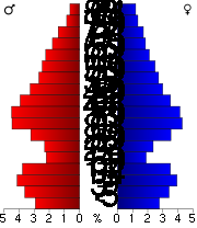
In the county, the population was spread out with 25.70% under the age of 18, 6.40% from 18 to 24, 28.70% from 25 to 44, 24.00% from 45 to 64, and 15.10% who were 65 years of age or older. The median age was 39 years. For every 100 females there were 101.30 males. For every 100 females age 18 and over, there were 99.70 males.
Oconto County is perennially among the poorest counties in Wisconsin. Stagnant growth turned to negative growth in the early years of the 21st century as employers left the region. Oconto County had an unemployment rate of over 10% in 2004.
History
First visited by French explorers in the 17th century, Oconto County is among the oldest settlements in Wisconsin. Father Claude-Jean AllouezClaude-Jean Allouez
Claude Jean Allouez was a Jesuit missionary and French explorer of North America.Allouez was born in Saint-Didier-en-Velay in the département of Haute-Loire in south-central France. In 1639, he graduated from the College of Le Puy, and became a Jesuit novice in Toulouse, France. In 1655, he was...
of the Roman Catholic Jesuit order said the first Mass in Oconto. Among the first settlers was Joseph Tourtilott, who explored much of the Oconto River watershed. Many of Tourtilott's descendants continue to reside in Oconto County, which has the highest percentage of residents with French ancestry in Wisconsin.
Cities
- GillettGillett, WisconsinGillett is a city in Oconto County, Wisconsin, United States. The population was 1,256 according to the 2000 census. It is part of the Green Bay Metropolitan Statistical Area...
- Oconto FallsOconto Falls, WisconsinOconto Falls is a city in Oconto County, Wisconsin, United States. The population was 2,843 at the 2000 census. It is part of the Green Bay Metropolitan Statistical Area.-Geography:Oconto Falls is located at ....
- OcontoOconto, WisconsinOconto is a city in Oconto County, Wisconsin, United States. The population was 4,708 at the 2000 census. It is part of the Green Bay Metropolitan Statistical Area. The city is located partially within the town of Oconto.-History:...
Villages
- LenaLena, WisconsinLena is a village in Oconto County, Wisconsin, United States. The population was 510 at the 2000 census. It is part of the Green Bay Metropolitan Statistical Area. The village is located within the Town of Lena.-History:...
- PulaskiPulaski, WisconsinPulaski is a village in Brown, Oconto, and Shawano Counties in the U.S. state of Wisconsin. The population was 3,060 at the 2000 census.The Brown and Oconto County portions of Pulaski are part of the Green Bay Metropolitan Statistical Area.-History:...
(partial) - SuringSuring, WisconsinSuring is a village in Oconto County, Wisconsin, United States, along the 45th parallel. The population was 605 at the 2000 census. It is part of the Green Bay Metropolitan Statistical Area.-Geography:Suring is located at ....
Towns
- AbramsAbrams, WisconsinAbrams is a town in Oconto County, Wisconsin, United States. The population was 1,757 at the 2000 Census. The census-designated place of Abrams is located in the town. Abrams in named after W. J...
- BagleyBagley, Oconto County, WisconsinBagley is a town in Oconto County, Wisconsin, United States. The population was 333 at the 2000 census.-Geography:According to the United States Census Bureau, the town has a total area of 35.7 square miles , of which, 34.8 square miles of it is land and 0.9 square miles of it is...
- BrazeauBrazeau, WisconsinBrazeau is a town in Oconto County, Wisconsin, United States. The population was 1,408 at the 2000 census.-Geography:According to the United States Census Bureau, the town has a total area of 71.6 square miles , of which, 68.5 square miles of it is land and 3.0 square miles of it ...
- BreedBreed, WisconsinBreed is a town in Oconto County, Wisconsin, United States. The population was 657 at the 2000 census. The unincorporated community of Breed is located in the town.-Geography:...
- ChaseChase, WisconsinChase is a town in Oconto County, Wisconsin, United States. The population was 2,082 at the 2000 census. The unincorporated communities of Chase and South Chase are located in the town...
- DotyDoty, WisconsinDoty is a town in Oconto County, Wisconsin, United States. The population was 249 at the 2000 census.-Geography:According to the United States Census Bureau, the town has a total area of 54.4 square miles , of which, 52.2 square miles of it is land and 2.2 square miles of it is...
- Gillett (town)Gillett (town), WisconsinGillett is a town in Oconto County, Wisconsin, United States. The population was 1,085 at the 2000 census. The City of Gillett is located within the town...
- HowHow, WisconsinHow is a town in Oconto County, Wisconsin, United States. The population was 563 at the 2000 census. The unincorporated community of Hayes is located in the town.-Geography:...
- LakewoodLakewood, WisconsinLakewood is a town in Oconto County, Wisconsin, United States. As of the 2000 census, the town population was 875. The census-designated place of Lakewood is located in the town.-Geography:...
- Lena (town)Lena (town), WisconsinLena is a town in Oconto County, Wisconsin, United States. The population was 769 at the 2000 census. The Village of Lena is located within the town.-Geography:...
- Little RiverLittle River, WisconsinLittle River is a town in Oconto County, Wisconsin, United States. The population was 1,065 at the 2000 census. The unincorporated community of County Line is located in the town.-Geography:...
- Little SuamicoLittle Suamico, WisconsinLittle Suamico is a town in Oconto County, Wisconsin, United States. The population was 3,877 at the 2000 census. The unincorporated communities of Little Suamico, Sobieski, and Sobieski Corners are located with the town.-History:...
- Maple ValleyMaple Valley, WisconsinMaple Valley is a town in Oconto County, Wisconsin, United States. The population was 670 at the 2000 census. The unincorporated communities of Frostville and Hickory Groves are located in the town.-Geography:...
- MorganMorgan, WisconsinMorgan is a town in Oconto County, Wisconsin, United States. The population was 882 at the 2000 census. The unincorporated communities of Morgan and Sampson are located in the town.-Geography:...
- MountainMountain, WisconsinMountain is a town in Oconto County, Wisconsin, United States. The population was 860 at the 2000 census. The census-designated place of Mountain is located within the town.-Geography:...
- Oconto Falls (town)Oconto Falls (town), WisconsinOconto Falls is a town in Oconto County, Wisconsin, United States. The population was 1,139 at the 2000 census. The City of Oconto Falls is located within the town.-Geography:...
- Oconto (town)Oconto (town), WisconsinOconto is a town in Oconto County, Wisconsin, United States. The population was 1,251 at the 2000 census. The City of Oconto is located partially within the town.-Geography:...
- PensaukeePensaukee, WisconsinPensaukee is a town in Oconto County, Wisconsin, United States. The population was 1,214 at the 2000 census. The unincorporated communities of Brookside, Oak Orchard, and Pensaukee are located in the town.-Geography:...
- RiverviewRiverview, WisconsinRiverview is a town in Oconto County, Wisconsin, United States. The population was 829 at the 2000 census.-Geography:According to the United States Census Bureau, the town has a total area of 71.7 square miles , of which, 69.7 square miles of it is land and 2.0 square miles of it ...
- SpruceSpruce, WisconsinSpruce is a town in Oconto County, Wisconsin, United States. The population was 871 at the 2000 census. The unincorporated communities of Klondike and Spruce are located in the town.-Geography:...
- StilesStiles, WisconsinStiles is a town in Oconto County, Wisconsin, United States. The population was 1,465 at the 2000 census. The unincorporated communities of Stiles and Stiles Junction are located in the town.-Geography:...
- TownsendTownsend, WisconsinTownsend is a town in Oconto County, Wisconsin, United States. The population was 963 at the 2000 census. The census-designated place of Townsend is located in the town.-Geography:...
- UnderhillUnderhill, WisconsinUnderhill is a town in Oconto County, Wisconsin, United States. The population was 846 at the 2000 census. The unincorporated communities of Hintz and Underhill are located in the town...
Unincorporated communities
- Abrams
- BreedBreed (community), WisconsinBreed is an unincorporated community located in the town of Breed, Oconto County, Wisconsin, United States. Breed is located at the junction of Wisconsin Highway 32 and County Highway AA north-northwest of Suring....
- BrooksideBrookside, WisconsinBrookside is an unincorporated community located in the town of Pensaukee, Oconto County, Wisconsin, United States. Brookside is located on County Highway J near U.S. Route 41, southwest of Oconto....
- ChaseChase (community), WisconsinChase is an unincorporated community located in the town of Chase, Oconto County, Wisconsin, United States. Chase is located at the junction of County Highways C and S northeast of Pulaski....
- County LineCounty Line, WisconsinCounty Line is an unincorporated community located on the border of Marinette and Oconto Counties, Wisconsin, United States. The Marinette County portion of the community is located in the town of Grover, while the Oconto County portion is located in the town of Little River. County Line is located...
(partial) - FrostvilleFrostville, WisconsinFrostville is an unincorporated community located in the town of Maple Valley, Oconto County, Wisconsin, United States....
- HayesHayes, WisconsinHayes is an unincorporated community located in the town of How, Oconto County, Wisconsin, United States....
- Hickory CornersHickory Corners, WisconsinHickory Corners is an unincorporated community located in the town of Maple Valley, Oconto County, Wisconsin, United States....
- HintzHintz, WisconsinHintz is an unincorporated community located in the town of Underhill, Oconto County, Wisconsin, United States. Hintz is located on the Oconto River and County Highway H west-northwest of Gillett....
- KlondikeKlondike, Oconto County, WisconsinKlondike is an unincorporated community in Oconto County, Wisconsin, United States. The community is located at the intersection of Oconto County Highways ZZ, B, and Z, in the town of Spruce. It is located at latitude 45.068 and longitude -88.16 and elevation 791 feet .-Notes:...
- KrakowKrakow, WisconsinKrakow is an unincorporated census-designated place located primarily in Shawano County, Wisconsin, United States with a small portion in Oconto County. Krakow is located on Wisconsin Highway 32 north of Pulaski, in the towns of Chase, and Angelica. Krakow has a post office with ZIP code 54137. As...
(partial) - Lakewood
- Little SuamicoLittle Suamico (community), WisconsinLittle Suamico is an unincorporated community located in the town of Little Suamico, Oconto County, Wisconsin, United States. Little Suamico is north-northeast of Suamico. Little Suamico has a post office with ZIP code 54141....
- MorganMorgan, Oconto County, WisconsinMorgan is an unincorporated community located in the town of Morgan, Oconto County, Wisconsin, United States....
- MoslingMosling, WisconsinMosling is an unincorporated community located in the towns of Gillett and Underhill, Oconto County, Wisconsin, United States. Mosling is located on County Highway P west-southwest of Gillett....
- MountainMountain (community), WisconsinMountain is an unincorporated census-designated place in Oconto County, Wisconsin, United States. The community is located at the intersection of Wisconsin Highway 32 and Wisconsin Highway 64, in the town of Mountain. It is located at latitude 45.185 and longitude -88.474 and elevation 971 feet ....
- Oak OrchardOak Orchard, WisconsinOak Orchard is an unincorporated community located in the town of Pensaukee, Oconto County, Wisconsin, United States....
- PensaukeePensaukee (community), WisconsinPensaukee is an unincorporated community located in the town of Pensaukee, Oconto County, Wisconsin, United States....
- SampsonSampson, Oconto County, WisconsinSampson is an unincorporated community in Oconto County, Wisconsin, United States. The community is located at the intersection of Oconto County Highways C and D, in the town of Morgan. It is located at latitude 44.765 and longitude -88.186 and elevation 787 feet .-Notes:...
- SobieskiSobieski, WisconsinSobieski, Wisconsin is an unincorporated census-designated place in Oconto County in northeastern Wisconsin. It is located within the town of Little Suamico. As of the 2010 census, its population is 259. Sobieski is home to six taverns, a daycare center, and a landfill of a Catholic church. It is...
- Sobieski CornersSobieski Corners, WisconsinSobieski Corners is an unincorporated community located in the town of Little Suamico, Oconto County, Wisconsin, United States....
- South ChaseSouth Chase, WisconsinSouth Chase is an unincorporated community located in the town of Chase, Oconto County, Wisconsin, United States. South Chase is located on County Highway C east-northeast of Pulaski....
- SpruceSpruce (community), WisconsinSpruce is an unincorporated community located in the town of Spruce, Oconto County, Wisconsin, United States....
- StilesStiles (community), WisconsinStiles is an unincorporated community in the town of Stiles in Oconto County, Wisconsin, United States. It is located on U.S. Route 141 at its intersections with County I, Wisconsin Highway 22 and the Oconto River....
- Stiles JunctionStiles Junction, WisconsinStiles Junction is an unincorporated community located in the town of Stiles, Oconto County, Wisconsin, United States....
- Townsend
- UnderhillUnderhill (community), WisconsinUnderhill is an unincorporated community located in the town of Underhill, Oconto County, Wisconsin, United States. Underhill is located on the Oconto River west-southwest of Gillett....


 U.S. Highway 41
 U.S. Highway 141