
Super Outbreak
Encyclopedia
The Super Outbreak is the second largest tornado outbreak
on record for a single 24-hour period, just behind the tornado outbreak of April 25–28, 2011
. From April 3 to April 4, 1974, there were 148 tornado
es confirmed in 13 US
states, including Illinois
, Indiana
, Michigan
, Ohio
, Kentucky
, Tennessee
, Alabama
, Mississippi
, Georgia
, North Carolina
, Virginia
, West Virginia
, and New York
; and the Canadian
province of Ontario
. It extensively damaged approximately 900 square miles (2,330 square kilometers) along a total combined path length of 2600 miles (4,184.3 km).
The Super Outbreak of tornadoes of 3–4 April 1974 remains one of the most outstanding severe convective weather episodes of record in the continental United States. The outbreak far surpassed previous and succeeding events in severity, longevity and extent, with the notable exception of the April 2011 outbreak. With a death toll of over 300, this outbreak was the deadliest since the 1936 Tupelo-Gainesville tornado outbreak. Its death toll would also not be surpassed until 2011, when that year's April 25-28 tornado outbreak
killed at least 340 people.
n Interior Plains
on April 1. While moving into the Mississippi and Ohio Valley areas, a surge of very moist air intensified the storm further while there were sharp temperature contrasts between both sides of the system. NOAA officials were expecting a severe weather outbreak on April 3, but not of the extent which ultimately occurred. Several F2 and F3 tornadoes had struck portions of the Ohio Valley and the South in a separate, earlier outbreak on April 1 and 2, and this earlier storm system included three killer tornadoes in Kentucky
, Alabama
, and Tennessee
. The town of Campbellsburg
, northeast of Louisville, was hard-hit in this earlier outbreak, with a large portion of the town destroyed by an F3. Between the two outbreaks, an additional tornado was reported in Indiana in the early morning hours of April 3, several hours before the official start of the outbreak.
On Wednesday, April 3, severe weather watches already were issued from the morning from south of the Great Lakes
, while in portions of the Upper Midwest, snow was reported, with heavy rain falling across central Michigan and much of Ontario. St. Louis, Missouri
was pounded by a very severe thunderstorm
early in the afternoon which, while it did not produce a tornado, did include damaging baseball-sized hailstones.
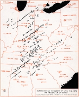
By the early afternoon, numerous supercell
s and clusters of thunderstorms developed and the outbreak began quickly, with storms developing in central Illinois and a secondary zone developing near the Appalachians across eastern Tennessee, central Alabama, and northern Georgia. The worst of the outbreak shifted towards the Ohio Valley between 4:30 pm and 6:30 pm EDT where it produced four of the six F5s over a span of just two hours when three powerful supercells traveled across the area—one in central and southern Ohio, a second one across southern Indiana and Ohio, and a third one in northern Kentucky.
During the evening hours, activity again began to escalate farther to the south, with several violent tornadoes crossing the northern third of Alabama. Activity also spread to central Tennessee and eastern Kentucky, with numerous tornadoes, most of which were concentrated in the Cumberland Plateau region. Additional supercells developed across northern Indiana and southern Michigan producing additional violent and/or killer tornadoes between 6:00 pm and 10:00 pm EDT including the Windsor, Ontario
tornado. Michigan was not hit as hard as neighboring states or Windsor, with only one twister which hit near Coldwater
and Hillsdale
causing any fatalities, all in mobile homes; however, thunderstorm downpours caused flash floods, and north of the warm front in the Upper Peninsula, heavy snowfall was reported.
Activity in the south moved towards the Appalachians during the overnight hours and produced the final tornadoes across the southeast during the morning of April 4.
A 2004 survey for Risk Management Solutions, citing an earlier Dr. Ted Fujita
study, found that three-quarters of all tornadoes in the Super Outbreak were produced by 30 'families
' of tornadoes; i.e., multiple tornadoes spawned in succession by a single thunderstorm cell. Note that most of these tornadoes were not associated with squall lines. These were long lived and long track supercells.
and F4
) tornadoes been observed in a single weather phenomenon. There were six F5 tornadoes and twenty-four F4 tornadoes. The outbreak began in Morris, Illinois
, at around 1:00pm on April 3. As the storm system moved east where daytime heating had made the air more unstable, the tornadoes grew more intense. A tornado that struck near Monticello, Indiana
was an F4 and had a path length of 121 miles (194.7 km), the longest path length of any tornado for this outbreak. Nineteen people were killed in this tornado. The first F5 tornado of the day struck the city of Xenia, Ohio
, at 4:40pm EDT. It killed 34, injured 1,150, completely destroyed about one-fourth of the city, and caused serious damage in another fourth of the city.
Six F5s were observed—one each in Indiana, Ohio and Kentucky, two in Alabama and the final one which crossed through parts of Indiana, Ohio and Kentucky. 31 were killed in Brandenburg, Kentucky
, and 30 died in Guin, Alabama
. One tornado also occurred in Windsor, Ontario
, Canada
, killing nine and injuring 30 others there, most of them at the former Windsor Curling Club. During the peak of the outbreak, a staggering sixteen tornadoes were on the ground simultaneously. At one point forecasters in Indiana, frustrated because they could not keep up with all of the simultaneous tornado activity, put the entire state of Indiana under a blanket tornado warning. This was the first and only time in U.S. history that an entire state was under a tornado warning.
There were 18 hours of continuous tornado activity. The outbreak finally ended in Caldwell County, NC, at about 7:00am on April 4. A total of 315 to 330 people were killed in 171 tornadoes from April 1 through April 4 and 5,484 were injured.
The Super Outbreak occurred at the end of a very strong, nearly record-setting La Niña
event. The 1973–74 La Niña was just as strong as the 1998–99 La Niña. Another tornado outbreak, which may be linked to La Niña, was the March 12, 2006 tornado outbreak
. Despite the apparent connection between La Niña and two of the largest tornado outbreaks in US history, no definitive linkage exists between La Niña and this outbreak or tornado activity in general.
Some tornado myths
were soundly debunked (not necessarily for the first time) by tornado activity during the outbreak.
The tornado formed near Bellbrook, Ohio
, southwest of Xenia
, at about 4:30pm EDT. It began as a moderate-sized tornado, then intensified while moving northeast at about 50 mph (80 km/h). A passing motorist filmed the tornado at its early stages and noticed that at one point two tornadoes formed and merged into one larger tornado.
Gil Whitney
, the weather specialist for WHIO-TV
in Dayton
, alerted viewers in Montgomery
and Greene County
(where Xenia is located) about the possible tornado, broadcasting the radar image of the supercell with a pronounced hook echo
on the rear flank of the storm several minutes before it actually struck. The storm was visible on radar because of raindrops wrapping around the circulation.
When the storm reached Xenia at 4:40pm, numerous structures were completely destroyed, including apartment buildings, homes, businesses, churches, and schools including Xenia High School
. The students that were in the school at the time were practicing for a play. One student, who witnessed the tornado heading directly toward their school, told the teacher that the tornado was coming. The teacher and students quickly took cover in the main hallway seconds before the school took a direct hit from the tornado.
A school bus that was parked outside the school was picked up and dropped on top of the stage the students were practicing on. The high school itself suffered extensive damage with the entire 2nd floor swept off the building. Several railroad cars were lifted and blown over as the tornado passed over a moving Penn Central freight train in the center of town.
The hardest hit area, and the first area struck, were the adjacent Arrowhead and Windsor Park subdivisions near U.S. Route 68
, where many houses were completely swept away. It toppled gravestones in Cherry Grove Cemetery, then moved through the length of the downtown business district, passing west of the courthouse, and into the Pinecrest Garden district, which was extensively affected. The still photo below shows the tornado as it passed Greene Memorial Hospital, destroying homes in Pinecrest Gardens northeast of downtown.
The Xenia tornado was recorded on film by one resident, and its sound was recorded on tape by another. There is a relationship between the footage and the recording. The resident who recorded the sound of the tornado did so from inside an apartment complex. Before the tornado hit the building, the resident left the tape recorder on, so it continued recording. The recorder was found after the storm, and the recording was made public. At the same time and a few blocks away, Xenia resident Bruce Boyd (who was 16 years old at the time), was able to capture 1 minute and 42 seconds of footage of the tornado with a "Super-8" 8mm movie camera, a pre-1973 model without sound recording capability. The footage from this film was later paired with the nearby tape recording made at the same time. The film, now on YouTube
, clearly shows multiple vortices within the larger circulation as the storm swept into and through Xenia.
A few pictures were taken of the tornado before it entered Xenia and later, as it was passing through the city. The early pictures of the tornado, which were taken by Homer G. Ramby, clearly show what the tornado looked like before entering Xenia. The photos taken from inside Xenia suggest that the tornado widened as it moved and turned into an F-5 inside the city.
Upon exiting Xenia, the tornado passed through Wilberforce
, heavily damaging several campus and residential buildings of Wilberforce University
. Central State University also sustained considerable damage. Afterwards, the tornado weakened before dissipating in Clark County
near South Vienna
, traveling a little over 30 miles (48.3 km). Its maximum width was a half-mile (0.8 km) in Xenia. The same parent storm later spawned a weaker tornado northeast of Columbus
in Franklin County
.
34 people were killed in the disaster, and about 1,150 were injured in Xenia alone. The death toll included two Ohio Air National Guard
smen deployed for disaster assistance who were killed on April 17 when a fire swept through their temporary barracks in a furniture store. About 1,400 buildings (roughly half of the town) were heavily damaged or destroyed. Damage was estimated at US$100 million.
President Richard Nixon
made an unannounced visit to Xenia a few days later. It would be the first (and only) city affected by the Super Outbreak that he would visit. Upon inspecting the damage, he said:
"As I look back over the disasters, I saw the earthquake
in Anchorage
in 1964; I saw the hurricanes... Hurricane Camille
in 1969 down in Mississippi
, and I saw Hurricane Agnes
in Wilkes-Barre, Pennsylvania
. And it is hard to tell the difference among them all, but I would say in terms of destruction, just total devastation, this is the worst I have seen."
President Nixon immediately declared Xenia a disaster area. Although the Federal Disaster Relief Act was already introduced in 1973, it still had not passed Congress. The Super Outbreak disaster was a catalyst for accelerated passage of the act through Congress in 1974, according to Nixon.
It took several months for the city to recover from the tornado, with the help of the Red Cross and the Ohio National Guard assisting the recovery efforts. Most of the town was quickly re-built afterward.
The Xenia tornado was one of two rated F5 that affected Ohio during the outbreak, the other striking the Cincinnati area (see Cincinnati/Sayler Park area tornado, below). Xenia was later struck by two other tornados -- both a smaller one in April 1989 and a larger one in September 2000, which was an F4 twister that killed one and injured about 100 in an area parallel to and just north of the 1974 path.
Before the 1974 storm, the city had no tornado sirens. After the F5 tornado hit on April 3, 1974, ten sirens were installed across the area.
Dr. Ted Fujita and a team of colleagues undertook a 10-month study of the Super Outbreak. Along with discovering much about tornadoes which was not known before, such as the downburst
and the microburst
, and accessing damage to surrounding structures, the Xenia tornado was determined to be the worst of the 148 storms.
A memorial was installed near Xenia City Hall to commemorate the 34 tornado victims.
The Brandenburg tornado, also producing F5 damage, touched down in Breckinridge County
at 4:25 pm CDT and followed a 34 miles (54.7 km) path. First producing F3 damage at the north edge of Hardinsburg
, the storm intensified as it moved into Meade County
, producing F5 damage as it swept through Brandenburg, along the Ohio River
before dissipating in Indiana
. 31 were killed in the storm including 18 at a single block of Green Street in Brandenburg. The vast majority of homes and businesses including the High School
, the Baptist Church, the old bank building and the Meade Hotel were either damaged or destroyed. The radio station WMMG (AM) was also destroyed. Sadly, the citizens of Brandenburg had received very little warning, which may account in part for the tragically high death toll; it has been reported that the only warning received by listeners to WMMG was when the disc jockey on duty looked out the window, saw the twister coming, and shouted at his listeners to take cover, shortly before the twister destroyed the radio station.
Several tombstones in the Cap Anderson cemetery
were toppled and broken, and some were displaced a small distance. Most of the trees vanished as well.
A complete description of homes and other structures destroyed in order by the tornado in Brandenburg can be found here.
When the twister struck on April 3, 1974, many of the Brandenburg residents at that time had also experienced a major flood
of the Ohio River that affected the area in 1937 as well as numerous other communities along the river, including Louisville and Paducah
.
The same storm would later produce tornadoes in the Louisville
metro area.
near Kosmosdale. Another funnel cloud
formed over Standiford Field Airport
, touched down at The Kentucky Fair and Exposition Center
, and destroyed the majority of the horse barns at the center and part of Freedom Hall
(a multipurpose arena
) before it crossed Interstate 65
, scattering several vehicles on that busy expressway. The tornado continued its 22 miles (35.4 km) journey northeast where it demolished most of Audubon Elementary School and affected the neighborhoods of Audubon
, Cherokee Triangle
, Cherokee-Seneca, Crescent Hill
, Indian Hills
, Northfield
, Rolling Hills
, and Tyler Park. The tornado ended near the junction of Interstates 264
and 71
after killing two people, injuring 207 people, destroying over 900 homes, and damaging thousands of others. Cherokee Park
, a historic 409 acres (1.7 km²) municipal park
located at Eastern Parkway and Cherokee Road, had thousands of mature trees destroyed. A massive re-planting effort was undertaken by the community in the aftermath of the tornado.
In addition to the two fatalities directly associated with the event, two other deaths were indirectly associated; a heart attack in the immediate aftermath and a construction worker who fell while repairing Freedom Hall two weeks later.
Dick Gilbert, a helicopter traffic reporter for radio station WHAS-AM, followed the tornado through portions of its track including when it heavily damaged the Louisville Water Company's Crescent Hill
pumping station, and gave vivid descriptions of the damage as seen from the air. A WHAS-TV
cameraman also filmed the tornado when it passed just east of the Central Business District
of Louisville.
WHAS-AM broke away from its regular programming shortly before the tornado struck Louisville and was on-air live with John Burke, the chief meteorologist at the National Weather Service
's Louisville office at Standiford Field when the tornado first descended. The station remained on the air delivering weather bulletins and storm-related information until well into the early morning hours of April 4. As electrical power had been knocked out to a substantial portion of the city, the radio station became a clearinghouse for vital information and contact with emergency workers, not only in Louisville but across the state of Kentucky due to its 50,000-watt clear-channel signal and the fact that storms had knocked numerous broadcasting stations in smaller communities, such as Frankfort
, off the air. Then-Governor Wendell Ford commended the station's personnel for their service to the community in the time of crisis, and Dick Gilbert later received a special commendation from then-President Richard Nixon
for his tracking of the tornado from his helicopter.
, traversing about 65 miles (104.6 km) through parts of Perry
and Harrison
Counties. F5 damage was observed near the community of Depauw
, while areas near Palmyra
, Martinsburg
and Borden
were also heavily affected by the tornado. All but 10 homes in Martinsburg were destroyed; in the Daisy Hill community homes were completely swept away. Published photographs of this storm reveal a very wide debris cloud and wall cloud structure, with no visible condensation funnel at times. Overall, six were killed by the storm and over 75 were injured. One of the fatalities was crushed by a school bus that flew into a ditch which she was taking cover. It was the only F5 that had a path width in excess of 1 miles (1.6 km).
Soon after the Depauw tornado lifted, the Hanover/Madison F4 twister formed near Henryville
and traveled through Jefferson County
and leveled many structures in the small towns of Hanover and Madison. Eleven were killed in this storm while an additional 300 were injured. According to a WHAS-TV
Louisville reporter in a special report about the outbreak, 90% of Hanover was destroyed or severely damaged, including the Hanover College
campus. Despite the fact that no one was killed or seriously injured at the college, 32 of the College's 33 buildings were damaged, including two that were completely destroyed and six that sustained major structural damage. Hundreds of trees were down, completely blocking every campus road. All utilities were knocked out and communication with those off campus was nearly impossible. Damage to the campus alone was estimated at about US$10 million. In Madison alone where seven of the fatalities took place, about 300 homes were destroyed and the tornado also brushed the community of China
causing additional fatalities.
The same storm would later strike the Cincinnati area, producing multiple tornadoes including another F5.
that devastated locations in Missouri
, Illinois
, and Indiana
on March 18, 1925. The Cincinnati/Sayler Park tornado (which has a much shorter path length than the Tri-State Tornado
) traveled through portions of Indiana
, Kentucky
and Ohio
.
The Sayler Park tornado was among a series of tornadoes that earlier struck portions of southern Indiana
from north of Brandenburg, Kentucky
, into southwest Ohio. It began shortly before 4:30 pm CDT or 5:30 pm EDT in southeastern Indiana in Ohio County
north of Rising Sun
near the Ohio River
. It then traveled through Boone County, Kentucky
, before reaching its peak intensity in the western suburbs of the Cincinnati Metropolitan area. Most severely affected was Sayler Park at the western edge of the city where F5 damage occurred. Homes were swept away in a hilly area near a lake, and boats were thrown and destroyed. Other areas near Cincinnati also suffered extensive damage to structures. This tornado was witnessed on television by thousands of people, as WCPO
aired the tornado live during special news coverage of the tornadoes.
Other areas affected were Bridgetown, Mack
, Dent
and Delhi
. Damage in Delhi was rated as high as F4.
The second so-called F5 "Tri-State" tornado killed 3 and injured over 100 in Hamilton County, Ohio
. It was considered the most-photographed tornado of the outbreak.
This tornado dissipated west of White Oak
but the same thunderstorm activity was responsible for two other tornado touchdowns in the Montgomery
and Mason
areas. The Mason tornado, which started in the northern Cincinnati subdivisions of Arlington Heights
and Elmwood Place
, was rated F4 and killed two, while the Warren County
tornado was rated an F2 and injured 10.
The storm that spawned this family of tornadoes weakened before moving through portions of the Miami Valley
and the rest of southern Ohio.
. According to most records, this tornado formed near Otterbein
in Benton County
in west central Indiana to Noble County
just northwest of Fort Wayne
- a total distance of about 121 miles (194.7 km).
Further analysis by Ted Fujita indicated that at the start of the tornado path near Otterbein, downburst winds (also called "twisting downburst") disrupted the tornado's inflow which caused it to briefly dissipate while a new tornado formed near Brookston
in White County at around 4:50 pm EDT and then traveled for 109 miles (175.4 km). It also struck portions of six other counties, with the hardest hit being White County
and its town of Monticello
. Much of the town was destroyed including the courthouse, some churches and cemeteries, 40 businesses and numerous homes as well as three schools. It also heavily damaged the Penn Central bridge over the Tippecanoe River
. Overall damage according to the NOAA was estimated at about US$250 million with US$100 million damage in Monticello alone.
Other communities such as Rochester
and Ligonier
were hard hit.
Nineteen were killed during the storm including five from Fort Wayne
when their mini-bus fell 50 feet (15 m) into the Tippecanoe River
near Monticello. One passenger did survive the fall. Five others were killed in White County, six in Fulton County
and one in Kosciusko County
. The National Guard
had assisted the residents in the relief and cleanup efforts and then-Governor Otis Bowen visited the area days after the storm.
One of the few consolations from the tornado was that a century-old bronze bell that belonged to the White County Courthouse and served as timekeeper was found intact despite being thrown a great distance.
The tornado itself had contradicted a long-time myth that a tornado would "not follow terrain into steep valleys" as while hitting Monticello, it descended a 60-foot (18 m) hill near the Tippecanoe River
and damaged several homes afterwards.
Most of the small town of Tanner
, west of Huntsville
in Limestone County
, was destroyed when two violent tornadoes struck the community 30 minutes apart. The first tornado formed at 6:30 pm CDT in Franklin County, Alabama
and ended just over 90 minutes later in Franklin County, Tennessee
. Serious damage from this first storm began in the Mt. Moriah community, with additional damage in the Phil Campbell area, and homes swept away near Moulton
. Crossing the Tennessee River
as a large waterspout
, the storm then slammed into Tanner before dissipating near Harvest. Eyewitnesses reported that the tornado was quite large and demolished everything along its 51-mile long path.
While rescue efforts were underway to look for people under the destroyed structures, few were aware that another equally violent tornado would strike the area. The path of the second tornado, which formed at 7:35 pm CDT was 50 miles in length, and the storm formed along the Tennessee River less than a mile from the path of the earlier storm; the first half of its path very closely paralleled its predecessor. Many of the structures that were missed by the first tornado in Tanner were demolished along with remaining portions of already damaged structures; the communities of Capshaw and Harvest were likewise struck twice.
Many other structures in Franklin, Limestone and Madison
counties were completely demolished, including significant portions of the communities of Harvest and Hazel Green
just northeast of Tanner.
The death toll from the two tornadoes was over 50 and over 400 were injured. Most of the fatalities occurred in and around the Tanner area. Over 1,000 houses, 200 mobile home
s and numerous other outbuildings, automobiles, power lines and trees were completely demolished or heavily damaged.
At least the first of the Tanner tornadoes is rated as an F5 according to most sources. However, National Weather Service
record shows that both of them were rated the highest-scale. The rating of the second Tanner tornado is still disputed by scientists and some of the regional NWS offices; analysis in one publication estimates F3-F4 damage along the majority of the second storm's path, with F5 damage in and around Tanner
This was the second state to have been hit by more than two F5s during the Super Outbreak. The next occurrence of two F5s hitting the same state on the same day happened in March 1990 in Kansas
. Meanwhile, the next F5 to hit the state was on April 4, 1977
near Birmingham
before heading northeast for nearly 2 hours towards the Jasper
area causing major damage to its downtown as the F4 storm struck at about 8:00 pm CDT. Damage was also reported in Cullman County
from the storm before it lifted. The storm killed at least 3 and injured over 150 while 500 buildings were destroyed and nearly 400 others severely damaged. At the same time, a third supercell was crossing the state line near the track of the previous two .
The Guin tornado was the longest-duration F5 tornado recorded in the outbreak. It formed at around 8:50 pm CDT near the Mississippi
-Alabama border and traveled over 100 miles (160.9 km) to just west of Huntsville
and lifted just after 10:30 pm CDT; the formation of this tornado was preceded by a number of reports of large hail and straight-line wind damage around Starkville, MS. The path of the Guin tornado was just a few dozen miles south of where the Tanner tornadoes struck about two hours earlier.
The tornado killed 23 in Guin in Marion County
and another five in the community of Delmar
in Winston County
. Close to 300 people in total were injured, and Guin was left in ruins.
A large number of homes (over 500) were leveled and the Bankhead National Forest lost a considerable number of trees when the tornado hit.
Huntsville was affected shortly before 11:00 pm EDT by a strong F3 tornado produced by the same thunderstorm. This tornado produced heavy damage in the south end of the city, eventually destroying nearly 1,000 structures.
The tornado first hit Redstone Arsenal, damaging or destroying 99 buildings. But thanks to early warning from a MP picket line on RideOut Road, there were only three, relatively minor, injuries. One of the buildings destroyed was a publications center for the Nuclear Weapons Training School on the Arsenal. For months afterwards, portions of classified documents were being returned by farmers in Tennessee and Alabama.
The tornado then reached the Monte Sano Mountain, which has an altitude of 1,640 feet (492 m). The National Weather Service
office at Huntsville Jetport
was briefly "closed and abandoned" due to the severe weather conditions.
history. Affecting Windsor, Ontario
and surrounding areas in southwestern Essex County
, the F3 twister killed nine people and injured over 20. All of the fatalities occurred inside a curling
rink (the former Windsor Curling Club) just south of the downtown area that was heavily damaged. This tornado is likely the same one that had touched down in Flat Rock
, Michigan
about 7:50 pm (19:50) Eastern Time. Since the storm arrived after dark, it was all the more dangerous.
The storm that brought it in was accompanied by lightning
, and torrential rains as it first touched down on southeastern edge of the Devonshire Mall
, which was undergoing a large addition. It severely damaged the steel structure for a new department store, though no one was on the site at the time. The tornado lifted as it crossed the E.C. Row Expressway, then touched down again tearing the roof off the vehicle painting facility at Chrysler Canada
's Windsor Assembly Plant. Once again, the facility was vacant, except for two security guards, due to re-tooling that was taking place. The guards took shelter in a secure room on the ground floor just moments before the tornado struck.
The tornado continued across a vacant field, directly behind the Windsor Curling Club. It struck the Club at exactly 8:09 pm, sending the large roof of the structure into the air, sending pieces of it into the surrounding neighborhood, and causing the back wall to collapse on the people inside. Those inside were unaware of the severe weather that had been bearing down on them, as they had been playing in a curling bonspiel
, and had no way of knowing about the tornado warnings that had been issued just twenty minutes earlier. This curling bonspiel was being sponsored by Chrysler Canada, also a victim of the tornado, when it tore the roof off its nearby paint facility.
One woman who narrowly escaped death happened to be entering the curling club from the east at the exact moment the tornado struck. The winds caught her as she opened the door, and she screamed for help and hung onto the large door handles. A man ran to her help, and grabbed her arms, as she was horizontal, and on the verge of being sucked away. Her shoes were sucked right off her feet and were never found.
Much of the city was briefly flooded with approximately 15 centimeters (6 inches) of water from the rain brought by the storm. Trees in Cherokee Park were defoliated, with nearby houses damaged in a path roughly 300–400 meters wide having the most damage. Most of the media in the Windsor and Essex County area
had been following the weather situation closely in the United States via radio and TV stations from Detroit, and had issued public alerts and warnings in concert with their American counterparts
. The Canadian Weather Service (now Environment Canada
) did not issue a tornado warning
until 8:15 pm (20:15), more than 5 minutes after the tornado had struck the Windsor Curling Club. In the aftermath of the tornado, the City of Windsor merged the Windsor Curling Club and Windsor Ladies' Curling Club with its Roseland Golf Course (now the Roseland Golf and Curling Club) in the south end of Windsor, moving from their location on Central Avenue, near Tecumseh Road.
While it was the only tornado reported in Canada from the outbreak, it was the country's deadliest since the 1946 one that killed 17—closer than one hundred meters from the path of this tornado.
Tornado outbreak
While there is no single agreed upon definition, generally at least 6-10 tornadoes produced by the same synoptic scale weather system is considered a tornado outbreak. The tornadoes usually occur within the same day, or continue into the early morning hours of the succeeding day, and within the...
on record for a single 24-hour period, just behind the tornado outbreak of April 25–28, 2011
April 25–28, 2011 tornado outbreak
An extremely large and violent tornado outbreak, the largest tornado outbreak ever recorded, and popularly known as the 2011 Super Outbreak, occurred from April 25 to 28, 2011. The outbreak affected the Southern, Midwestern, and Northeastern United States, leaving catastrophic destruction in...
. From April 3 to April 4, 1974, there were 148 tornado
Tornado
A tornado is a violent, dangerous, rotating column of air that is in contact with both the surface of the earth and a cumulonimbus cloud or, in rare cases, the base of a cumulus cloud. They are often referred to as a twister or a cyclone, although the word cyclone is used in meteorology in a wider...
es confirmed in 13 US
United States
The United States of America is a federal constitutional republic comprising fifty states and a federal district...
states, including Illinois
Illinois
Illinois is the fifth-most populous state of the United States of America, and is often noted for being a microcosm of the entire country. With Chicago in the northeast, small industrial cities and great agricultural productivity in central and northern Illinois, and natural resources like coal,...
, Indiana
Indiana
Indiana is a US state, admitted to the United States as the 19th on December 11, 1816. It is located in the Midwestern United States and Great Lakes Region. With 6,483,802 residents, the state is ranked 15th in population and 16th in population density. Indiana is ranked 38th in land area and is...
, Michigan
Michigan
Michigan is a U.S. state located in the Great Lakes Region of the United States of America. The name Michigan is the French form of the Ojibwa word mishigamaa, meaning "large water" or "large lake"....
, Ohio
Ohio
Ohio is a Midwestern state in the United States. The 34th largest state by area in the U.S.,it is the 7th‑most populous with over 11.5 million residents, containing several major American cities and seven metropolitan areas with populations of 500,000 or more.The state's capital is Columbus...
, Kentucky
Kentucky
The Commonwealth of Kentucky is a state located in the East Central United States of America. As classified by the United States Census Bureau, Kentucky is a Southern state, more specifically in the East South Central region. Kentucky is one of four U.S. states constituted as a commonwealth...
, Tennessee
Tennessee
Tennessee is a U.S. state located in the Southeastern United States. It has a population of 6,346,105, making it the nation's 17th-largest state by population, and covers , making it the 36th-largest by total land area...
, Alabama
Alabama
Alabama is a state located in the southeastern region of the United States. It is bordered by Tennessee to the north, Georgia to the east, Florida and the Gulf of Mexico to the south, and Mississippi to the west. Alabama ranks 30th in total land area and ranks second in the size of its inland...
, Mississippi
Mississippi
Mississippi is a U.S. state located in the Southern United States. Jackson is the state capital and largest city. The name of the state derives from the Mississippi River, which flows along its western boundary, whose name comes from the Ojibwe word misi-ziibi...
, Georgia
Georgia (U.S. state)
Georgia is a state located in the southeastern United States. It was established in 1732, the last of the original Thirteen Colonies. The state is named after King George II of Great Britain. Georgia was the fourth state to ratify the United States Constitution, on January 2, 1788...
, North Carolina
North Carolina
North Carolina is a state located in the southeastern United States. The state borders South Carolina and Georgia to the south, Tennessee to the west and Virginia to the north. North Carolina contains 100 counties. Its capital is Raleigh, and its largest city is Charlotte...
, Virginia
Virginia
The Commonwealth of Virginia , is a U.S. state on the Atlantic Coast of the Southern United States. Virginia is nicknamed the "Old Dominion" and sometimes the "Mother of Presidents" after the eight U.S. presidents born there...
, West Virginia
West Virginia
West Virginia is a state in the Appalachian and Southeastern regions of the United States, bordered by Virginia to the southeast, Kentucky to the southwest, Ohio to the northwest, Pennsylvania to the northeast and Maryland to the east...
, and New York
New York
New York is a state in the Northeastern region of the United States. It is the nation's third most populous state. New York is bordered by New Jersey and Pennsylvania to the south, and by Connecticut, Massachusetts and Vermont to the east...
; and the Canadian
Canada
Canada is a North American country consisting of ten provinces and three territories. Located in the northern part of the continent, it extends from the Atlantic Ocean in the east to the Pacific Ocean in the west, and northward into the Arctic Ocean...
province of Ontario
Ontario
Ontario is a province of Canada, located in east-central Canada. It is Canada's most populous province and second largest in total area. It is home to the nation's most populous city, Toronto, and the nation's capital, Ottawa....
. It extensively damaged approximately 900 square miles (2,330 square kilometers) along a total combined path length of 2600 miles (4,184.3 km).
The Super Outbreak of tornadoes of 3–4 April 1974 remains one of the most outstanding severe convective weather episodes of record in the continental United States. The outbreak far surpassed previous and succeeding events in severity, longevity and extent, with the notable exception of the April 2011 outbreak. With a death toll of over 300, this outbreak was the deadliest since the 1936 Tupelo-Gainesville tornado outbreak. Its death toll would also not be surpassed until 2011, when that year's April 25-28 tornado outbreak
April 25–28, 2011 tornado outbreak
An extremely large and violent tornado outbreak, the largest tornado outbreak ever recorded, and popularly known as the 2011 Super Outbreak, occurred from April 25 to 28, 2011. The outbreak affected the Southern, Midwestern, and Northeastern United States, leaving catastrophic destruction in...
killed at least 340 people.
Meteorological synopsis
A powerful spring-time low pressure system developed across the North AmericaNorth America
North America is a continent wholly within the Northern Hemisphere and almost wholly within the Western Hemisphere. It is also considered a northern subcontinent of the Americas...
n Interior Plains
Interior Plains
The Interior Plains is a vast physiographic region that spreads across the Laurentian craton of central North America.-Geography:The Interior Plains are an extensive physiographic division encompassing 8 distinct physiographic provinces, the Interior Low Plateaus, Great Plains, Central Lowland,...
on April 1. While moving into the Mississippi and Ohio Valley areas, a surge of very moist air intensified the storm further while there were sharp temperature contrasts between both sides of the system. NOAA officials were expecting a severe weather outbreak on April 3, but not of the extent which ultimately occurred. Several F2 and F3 tornadoes had struck portions of the Ohio Valley and the South in a separate, earlier outbreak on April 1 and 2, and this earlier storm system included three killer tornadoes in Kentucky
Kentucky
The Commonwealth of Kentucky is a state located in the East Central United States of America. As classified by the United States Census Bureau, Kentucky is a Southern state, more specifically in the East South Central region. Kentucky is one of four U.S. states constituted as a commonwealth...
, Alabama
Alabama
Alabama is a state located in the southeastern region of the United States. It is bordered by Tennessee to the north, Georgia to the east, Florida and the Gulf of Mexico to the south, and Mississippi to the west. Alabama ranks 30th in total land area and ranks second in the size of its inland...
, and Tennessee
Tennessee
Tennessee is a U.S. state located in the Southeastern United States. It has a population of 6,346,105, making it the nation's 17th-largest state by population, and covers , making it the 36th-largest by total land area...
. The town of Campbellsburg
Campbellsburg, Kentucky
Campbellsburg is a city in Henry County, Kentucky, United States. The population was 705 at the 2000 census.-Geography:Campbellsburg is located at ....
, northeast of Louisville, was hard-hit in this earlier outbreak, with a large portion of the town destroyed by an F3. Between the two outbreaks, an additional tornado was reported in Indiana in the early morning hours of April 3, several hours before the official start of the outbreak.
On Wednesday, April 3, severe weather watches already were issued from the morning from south of the Great Lakes
Great Lakes
The Great Lakes are a collection of freshwater lakes located in northeastern North America, on the Canada – United States border. Consisting of Lakes Superior, Michigan, Huron, Erie, and Ontario, they form the largest group of freshwater lakes on Earth by total surface, coming in second by volume...
, while in portions of the Upper Midwest, snow was reported, with heavy rain falling across central Michigan and much of Ontario. St. Louis, Missouri
St. Louis, Missouri
St. Louis is an independent city on the eastern border of Missouri, United States. With a population of 319,294, it was the 58th-largest U.S. city at the 2010 U.S. Census. The Greater St...
was pounded by a very severe thunderstorm
Thunderstorm
A thunderstorm, also known as an electrical storm, a lightning storm, thundershower or simply a storm is a form of weather characterized by the presence of lightning and its acoustic effect on the Earth's atmosphere known as thunder. The meteorologically assigned cloud type associated with the...
early in the afternoon which, while it did not produce a tornado, did include damaging baseball-sized hailstones.
By the early afternoon, numerous supercell
Supercell
A supercell is a thunderstorm that is characterized by the presence of a mesocyclone: a deep, continuously-rotating updraft. For this reason, these storms are sometimes referred to as rotating thunderstorms...
s and clusters of thunderstorms developed and the outbreak began quickly, with storms developing in central Illinois and a secondary zone developing near the Appalachians across eastern Tennessee, central Alabama, and northern Georgia. The worst of the outbreak shifted towards the Ohio Valley between 4:30 pm and 6:30 pm EDT where it produced four of the six F5s over a span of just two hours when three powerful supercells traveled across the area—one in central and southern Ohio, a second one across southern Indiana and Ohio, and a third one in northern Kentucky.
During the evening hours, activity again began to escalate farther to the south, with several violent tornadoes crossing the northern third of Alabama. Activity also spread to central Tennessee and eastern Kentucky, with numerous tornadoes, most of which were concentrated in the Cumberland Plateau region. Additional supercells developed across northern Indiana and southern Michigan producing additional violent and/or killer tornadoes between 6:00 pm and 10:00 pm EDT including the Windsor, Ontario
Windsor, Ontario
Windsor is the southernmost city in Canada and is located in Southwestern Ontario at the western end of the heavily populated Quebec City – Windsor Corridor. It is within Essex County, Ontario, although administratively separated from the county government. Separated by the Detroit River, Windsor...
tornado. Michigan was not hit as hard as neighboring states or Windsor, with only one twister which hit near Coldwater
Coldwater, Michigan
Coldwater is a city in the U.S. state of Michigan. As of the 2010 census, the city population was 10,945. It is the county seat of Branch County....
and Hillsdale
Hillsdale, Michigan
Hillsdale is a city in the state of Michigan. As of the 2010 census, the city population was 8,305. It is the county seat of Hillsdale County, and is run as a council-manager government....
causing any fatalities, all in mobile homes; however, thunderstorm downpours caused flash floods, and north of the warm front in the Upper Peninsula, heavy snowfall was reported.
Activity in the south moved towards the Appalachians during the overnight hours and produced the final tornadoes across the southeast during the morning of April 4.
A 2004 survey for Risk Management Solutions, citing an earlier Dr. Ted Fujita
Ted Fujita
was a prominent severe storms researcher. His research at the University of Chicago on severe thunderstorms, tornadoes, hurricanes and typhoons revolutionized knowledge of each.- Biography :Fujita was born in Kitakyūshū, Fukuoka Prefecture, Japan...
study, found that three-quarters of all tornadoes in the Super Outbreak were produced by 30 'families
Tornado family
A tornado family is a series of tornadoes spawned by the same supercell. These families form a line of successive or parallel tornado paths and can cover a short span or a vast distance. Tornado families are sometimes mistaken as a single continuous tornado, especially prior to the 1970s...
' of tornadoes; i.e., multiple tornadoes spawned in succession by a single thunderstorm cell. Note that most of these tornadoes were not associated with squall lines. These were long lived and long track supercells.
Events and aftermath
Never before had so many violent (F5Fujita scale
The Fujita scale , or Fujita-Pearson scale, is a scale for rating tornado intensity, based primarily on the damage tornadoes inflict on human-built structures and vegetation...
and F4
Fujita scale
The Fujita scale , or Fujita-Pearson scale, is a scale for rating tornado intensity, based primarily on the damage tornadoes inflict on human-built structures and vegetation...
) tornadoes been observed in a single weather phenomenon. There were six F5 tornadoes and twenty-four F4 tornadoes. The outbreak began in Morris, Illinois
Morris, Illinois
Morris is a city in Grundy County, Illinois, United States. The population was 13,636 at the 2010 census.Morris is home to the Dresden Nuclear Power Plant, which provides a substantial portion of the electricity supply for the Chicago metropolitan area...
, at around 1:00pm on April 3. As the storm system moved east where daytime heating had made the air more unstable, the tornadoes grew more intense. A tornado that struck near Monticello, Indiana
Monticello, Indiana
Monticello is a city in White County, Indiana, United States. The population was 5,378 at the 2010 census. The city is the county seat of White County....
was an F4 and had a path length of 121 miles (194.7 km), the longest path length of any tornado for this outbreak. Nineteen people were killed in this tornado. The first F5 tornado of the day struck the city of Xenia, Ohio
Xenia, Ohio
Xenia is a city in and the county seat of Greene County, Ohio, United States. The municipality is located in southwestern Ohio 21 miles from Dayton and is part of the Dayton Metropolitan Statistical Area...
, at 4:40pm EDT. It killed 34, injured 1,150, completely destroyed about one-fourth of the city, and caused serious damage in another fourth of the city.
Six F5s were observed—one each in Indiana, Ohio and Kentucky, two in Alabama and the final one which crossed through parts of Indiana, Ohio and Kentucky. 31 were killed in Brandenburg, Kentucky
Brandenburg, Kentucky
Brandenburg is a city in Meade County, Kentucky, United States, along the Ohio River. The population was 2,049 at the 2000 census. It is the county seat of Meade County.-History:...
, and 30 died in Guin, Alabama
Guin, Alabama
Guin is a city in Marion County, Alabama, United States. At the 2000 census the population was 2,389. On July 13, 2010, the citizens of Guin voted to become the first city in Marion County, since Prohibition, to allow the sale of alcohol....
. One tornado also occurred in Windsor, Ontario
Windsor, Ontario
Windsor is the southernmost city in Canada and is located in Southwestern Ontario at the western end of the heavily populated Quebec City – Windsor Corridor. It is within Essex County, Ontario, although administratively separated from the county government. Separated by the Detroit River, Windsor...
, Canada
Canada
Canada is a North American country consisting of ten provinces and three territories. Located in the northern part of the continent, it extends from the Atlantic Ocean in the east to the Pacific Ocean in the west, and northward into the Arctic Ocean...
, killing nine and injuring 30 others there, most of them at the former Windsor Curling Club. During the peak of the outbreak, a staggering sixteen tornadoes were on the ground simultaneously. At one point forecasters in Indiana, frustrated because they could not keep up with all of the simultaneous tornado activity, put the entire state of Indiana under a blanket tornado warning. This was the first and only time in U.S. history that an entire state was under a tornado warning.
There were 18 hours of continuous tornado activity. The outbreak finally ended in Caldwell County, NC, at about 7:00am on April 4. A total of 315 to 330 people were killed in 171 tornadoes from April 1 through April 4 and 5,484 were injured.
The Super Outbreak occurred at the end of a very strong, nearly record-setting La Niña
La Niña
La Niña is a coupled ocean-atmosphere phenomenon that is the counterpart of El Niño as part of the broader El Niño-Southern Oscillation climate pattern. During a period of La Niña, the sea surface temperature across the equatorial Eastern Central Pacific Ocean will be lower than normal by 3–5 °C...
event. The 1973–74 La Niña was just as strong as the 1998–99 La Niña. Another tornado outbreak, which may be linked to La Niña, was the March 12, 2006 tornado outbreak
March 2006 Tornado Outbreak Sequence
The March 2006 Tornado Outbreak Sequence was an early season and long lasting tornado outbreak sequence in the central United States that started on the morning of March 9 and continued for over four days until the evening of March 13. The outbreak produced 105 confirmed tornadoes. At least 13...
. Despite the apparent connection between La Niña and two of the largest tornado outbreaks in US history, no definitive linkage exists between La Niña and this outbreak or tornado activity in general.
Some tornado myths
Tornado myths
Despite the fact that many misconceptions about tornadoes are no longer prevalent, many still remain. This can be attributed to many factors, including stories and news reports told by people unfamiliar with tornadoes, sensationalism by news media and the presentation of incorrect information in...
were soundly debunked (not necessarily for the first time) by tornado activity during the outbreak.
Xenia, Ohio
The tornado that struck the city of Xenia, Ohio stands as the deadliest individual tornado of the Super Outbreak, killing 34 and destroying a significant portion of the town. It was one of the most intense storms then recorded, stripping some trees bare of their branches, snapping large trees in half and depositing their crowns 50 yards away, and leveling nearly all structures in the damage path. Along with the 1999 Moore, Oklahoma tornado (which produced 318 mph winds), the 1974 Xenia tornado is one of the strongest ever recorded.The tornado formed near Bellbrook, Ohio
Bellbrook, Ohio
Bellbrook is a city in Greene County, Ohio, United States. The population was 6,943 at the 2010 census. It is part of the Dayton Metropolitan Statistical Area.-History:Bellbrook was first settled in 1814...
, southwest of Xenia
Xenia, Ohio
Xenia is a city in and the county seat of Greene County, Ohio, United States. The municipality is located in southwestern Ohio 21 miles from Dayton and is part of the Dayton Metropolitan Statistical Area...
, at about 4:30pm EDT. It began as a moderate-sized tornado, then intensified while moving northeast at about 50 mph (80 km/h). A passing motorist filmed the tornado at its early stages and noticed that at one point two tornadoes formed and merged into one larger tornado.
Gil Whitney
Gil Whitney
Gil Whitney was an American television weather forecaster notable for warning WHIO-TV viewers and listeners on April 3, 1974 of the tornado that went through Xenia, Ohio in the 1974 multi-tornado event known as the Super Outbreak...
, the weather specialist for WHIO-TV
WHIO-TV
WHIO-TV, virtual channel 7, is the CBS-affiliated television station licensed to Dayton, Ohio, serving that state's Miami Valley area. It broadcasts a high definition digital signal on UHF channel 41 from its transmitter on Germantown Street in western Dayton....
in Dayton
Dayton, Ohio
Dayton is the 6th largest city in the U.S. state of Ohio and the county seat of Montgomery County, the fifth most populous county in the state. The population was 141,527 at the 2010 census. The Dayton Metropolitan Statistical Area had a population of 841,502 in the 2010 census...
, alerted viewers in Montgomery
Montgomery County, Ohio
Montgomery County is a county located in the state of Ohio, United States. The population was 535,153 in the 2010 Census. It was named in honor of Richard Montgomery, an American Revolutionary War general killed in 1775 while attempting to capture Quebec City, Canada. The county seat is Dayton...
and Greene County
Greene County, Ohio
Greene County is a county located in the state of Ohio, United States. The population was 161,573 in the 2010 Census. Its county seat is Xenia, and it was named for General Nathanael Greene, an officer in the Revolutionary War. Greene County was established on March 24, 1803.Greene County is part...
(where Xenia is located) about the possible tornado, broadcasting the radar image of the supercell with a pronounced hook echo
Hook echo
The hook echo is one of the classical hallmarks of tornado-producing supercell thunderstorms as seen on a weather radar. The echo is produced by rain, hail, or even debris being wrapped around the supercell...
on the rear flank of the storm several minutes before it actually struck. The storm was visible on radar because of raindrops wrapping around the circulation.
When the storm reached Xenia at 4:40pm, numerous structures were completely destroyed, including apartment buildings, homes, businesses, churches, and schools including Xenia High School
Xenia High School
Xenia High School is a public high school in Xenia, Ohio. It is the only high school in the Xenia Community Schools district. The school's average daily student enrollment for the 2008-2009 school year was 1452. The Ohio Department of Education has given Xenia High School a rating of "Continuous...
. The students that were in the school at the time were practicing for a play. One student, who witnessed the tornado heading directly toward their school, told the teacher that the tornado was coming. The teacher and students quickly took cover in the main hallway seconds before the school took a direct hit from the tornado.
A school bus that was parked outside the school was picked up and dropped on top of the stage the students were practicing on. The high school itself suffered extensive damage with the entire 2nd floor swept off the building. Several railroad cars were lifted and blown over as the tornado passed over a moving Penn Central freight train in the center of town.
The hardest hit area, and the first area struck, were the adjacent Arrowhead and Windsor Park subdivisions near U.S. Route 68
U.S. Route 68
U.S. Route 68 is an east–west United States highway that runs for from northwest Ohio to western Kentucky. The highway's western terminus is at U.S. Route 62 in Reidland, Kentucky. Its eastern terminus is at Interstate 75 in Findlay, Ohio...
, where many houses were completely swept away. It toppled gravestones in Cherry Grove Cemetery, then moved through the length of the downtown business district, passing west of the courthouse, and into the Pinecrest Garden district, which was extensively affected. The still photo below shows the tornado as it passed Greene Memorial Hospital, destroying homes in Pinecrest Gardens northeast of downtown.
The Xenia tornado was recorded on film by one resident, and its sound was recorded on tape by another. There is a relationship between the footage and the recording. The resident who recorded the sound of the tornado did so from inside an apartment complex. Before the tornado hit the building, the resident left the tape recorder on, so it continued recording. The recorder was found after the storm, and the recording was made public. At the same time and a few blocks away, Xenia resident Bruce Boyd (who was 16 years old at the time), was able to capture 1 minute and 42 seconds of footage of the tornado with a "Super-8" 8mm movie camera, a pre-1973 model without sound recording capability. The footage from this film was later paired with the nearby tape recording made at the same time. The film, now on YouTube
YouTube
YouTube is a video-sharing website, created by three former PayPal employees in February 2005, on which users can upload, view and share videos....
, clearly shows multiple vortices within the larger circulation as the storm swept into and through Xenia.
A few pictures were taken of the tornado before it entered Xenia and later, as it was passing through the city. The early pictures of the tornado, which were taken by Homer G. Ramby, clearly show what the tornado looked like before entering Xenia. The photos taken from inside Xenia suggest that the tornado widened as it moved and turned into an F-5 inside the city.
Upon exiting Xenia, the tornado passed through Wilberforce
Wilberforce, Ohio
Wilberforce is a census-designated place in Greene County, Ohio, United States. The population was 1,579 at the 2000 census. The community was named for the English statesman William Wilberforce, who worked for abolition of slavery and achieved the end of the slave trade in the United Kingdom and...
, heavily damaging several campus and residential buildings of Wilberforce University
Wilberforce University
Wilberforce University is a private, coed, liberal arts historically black university located in Wilberforce, Ohio. Affiliated with the African Methodist Episcopal Church, it was the first college to be owned and operated by African Americans...
. Central State University also sustained considerable damage. Afterwards, the tornado weakened before dissipating in Clark County
Clark County, Ohio
As of the census of 2000, there were 144,742 people, 56,648 households, and 39,370 families residing in the county. The population density was 362 people per square mile . There were 61,056 housing units at an average density of 153 per square mile...
near South Vienna
South Vienna, Ohio
South Vienna is a village in Clark County, Ohio, United States. The population was 469 at the 2000 census. It is part of the Springfield, Ohio Metropolitan Statistical Area....
, traveling a little over 30 miles (48.3 km). Its maximum width was a half-mile (0.8 km) in Xenia. The same parent storm later spawned a weaker tornado northeast of Columbus
Columbus, Ohio
Columbus is the capital of and the largest city in the U.S. state of Ohio. The broader metropolitan area encompasses several counties and is the third largest in Ohio behind those of Cleveland and Cincinnati. Columbus is the third largest city in the American Midwest, and the fifteenth largest city...
in Franklin County
Franklin County, Ohio
Franklin County is a county located in the state of Ohio, United States. In 2010 the population was 1,163,414, making it the second largest county in Ohio and the 34th largest county in population in the United States. Franklin County is also the largest in the eight-county Columbus, Ohio...
.
34 people were killed in the disaster, and about 1,150 were injured in Xenia alone. The death toll included two Ohio Air National Guard
Ohio Air National Guard
The Ohio Air National Guard is a part of the United States National Guard and an Air Reserve Component of the United States Air Force. It is composed of approximately 5,000 airmen and officers assigned to four flying wings and eight non-flying support units. OHANG units are based in Columbus,...
smen deployed for disaster assistance who were killed on April 17 when a fire swept through their temporary barracks in a furniture store. About 1,400 buildings (roughly half of the town) were heavily damaged or destroyed. Damage was estimated at US$100 million.
President Richard Nixon
Richard Nixon
Richard Milhous Nixon was the 37th President of the United States, serving from 1969 to 1974. The only president to resign the office, Nixon had previously served as a US representative and senator from California and as the 36th Vice President of the United States from 1953 to 1961 under...
made an unannounced visit to Xenia a few days later. It would be the first (and only) city affected by the Super Outbreak that he would visit. Upon inspecting the damage, he said:
"As I look back over the disasters, I saw the earthquake
Earthquake
An earthquake is the result of a sudden release of energy in the Earth's crust that creates seismic waves. The seismicity, seismism or seismic activity of an area refers to the frequency, type and size of earthquakes experienced over a period of time...
in Anchorage
Anchorage, Alaska
Anchorage is a unified home rule municipality in the southcentral part of the U.S. state of Alaska. It is the northernmost major city in the United States...
in 1964; I saw the hurricanes... Hurricane Camille
Hurricane Camille
Hurricane Camille was the third and strongest tropical cyclone and second hurricane during the 1969 Atlantic hurricane season. The second of three catastrophic Category 5 hurricanes to make landfall in the United States during the 20th century , which it did near the mouth of the Mississippi River...
in 1969 down in Mississippi
Mississippi
Mississippi is a U.S. state located in the Southern United States. Jackson is the state capital and largest city. The name of the state derives from the Mississippi River, which flows along its western boundary, whose name comes from the Ojibwe word misi-ziibi...
, and I saw Hurricane Agnes
Hurricane Agnes
Hurricane Agnes was the first tropical storm and first hurricane of the 1972 Atlantic hurricane season. A rare June hurricane, it made landfall on the Florida Panhandle before moving northeastward and ravaging the Mid-Atlantic region as a tropical storm...
in Wilkes-Barre, Pennsylvania
Wilkes-Barre, Pennsylvania
Wilkes-Barre is a city in the U.S. state of Pennsylvania, the county seat of Luzerne County. It is at the center of the Wyoming Valley area and is one of the principal cities in the Scranton/Wilkes-Barre metropolitan area, which had a population of 563,631 as of the 2010 Census...
. And it is hard to tell the difference among them all, but I would say in terms of destruction, just total devastation, this is the worst I have seen."
President Nixon immediately declared Xenia a disaster area. Although the Federal Disaster Relief Act was already introduced in 1973, it still had not passed Congress. The Super Outbreak disaster was a catalyst for accelerated passage of the act through Congress in 1974, according to Nixon.
It took several months for the city to recover from the tornado, with the help of the Red Cross and the Ohio National Guard assisting the recovery efforts. Most of the town was quickly re-built afterward.
The Xenia tornado was one of two rated F5 that affected Ohio during the outbreak, the other striking the Cincinnati area (see Cincinnati/Sayler Park area tornado, below). Xenia was later struck by two other tornados -- both a smaller one in April 1989 and a larger one in September 2000, which was an F4 twister that killed one and injured about 100 in an area parallel to and just north of the 1974 path.
Before the 1974 storm, the city had no tornado sirens. After the F5 tornado hit on April 3, 1974, ten sirens were installed across the area.
Dr. Ted Fujita and a team of colleagues undertook a 10-month study of the Super Outbreak. Along with discovering much about tornadoes which was not known before, such as the downburst
Downburst
A downburst is created by an area of significantly rain-cooled air that, after reaching ground level, spreads out in all directions producing strong winds. Unlike winds in a tornado, winds in a downburst are directed outwards from the point where it hits land or water...
and the microburst
Microburst
A microburst is a very localized column of sinking air, producing damaging divergent and straight-line winds at the surface that are similar to, but distinguishable from, tornadoes, which generally have convergent damage. There are two types of microbursts: wet microbursts and dry microbursts...
, and accessing damage to surrounding structures, the Xenia tornado was determined to be the worst of the 148 storms.
A memorial was installed near Xenia City Hall to commemorate the 34 tornado victims.
Brandenburg, Kentucky tornado
| Outbreak death toll | |||
| State/Province | Total | County | County total |
|---|---|---|---|
| Alabama Alabama Alabama is a state located in the southeastern region of the United States. It is bordered by Tennessee to the north, Georgia to the east, Florida and the Gulf of Mexico to the south, and Mississippi to the west. Alabama ranks 30th in total land area and ranks second in the size of its inland... |
77 | Cullman Cullman County, Alabama Cullman County is a county of the U.S. state of Alabama. Its name is in honor of Colonel John G. Cullmann. As of 2010, the population was 80,406. Its county seat is the town of the same name, Cullman, Alabama. It is a "moist" county in terms of availablity of alcoholic beverages, which means... |
1 |
| Fayette Fayette County, Alabama Fayette County is a county of the U.S. state of Alabama. Its name is in honor of the Marquis de Lafayette , who aided General George Washington in the American Revolutionary War. As of 2010 the population was 17,241... |
2 | ||
| Lawrence Lawrence County, Alabama Lawrence County is a county of the U.S. state of Alabama, and is included in the Decatur Metropolitan Area, as well as the Huntsville-Decatur Combined Statistical Area. It was named after James Lawrence, a captain in the United States Navy from New Jersey. As of the 2010 census, the population was... |
14 | ||
| Limestone Limestone County, Alabama Limestone County is a county of the U.S. state of Alabama, and is included in the Huntsville Metropolitan Area.It is also included in the merged Huntsville-Decatur Metro Area. Its name comes from Limestone Creek, a local stream. In 2000, the population was 65,676. As of 2010 the county's... |
16 | ||
| Madison Madison County, Alabama Madison County is a county of the U.S. state of Alabama, and is a major part of the Huntsville Metropolitan Area.It is also included in the merged Huntsville-Decatur Combined Statistical Area. The county is named in honor of James Madison, fourth President of the United States of America, and the... |
16 | ||
| Marion Marion County, Alabama Marion County is a county of the U.S. state of Alabama. Marion County was created by an act of the Alabama Territorial General Assembly on February 13, 1818. The county is located in the northwestern part of the state, bounded on the west by the state of Mississippi. It encompasses . Marion County... |
23 | ||
| Winston Winston County, Alabama Winston County is a county of the U.S. state of Alabama, formerly known as Hancock County before 1858.Its name is in honor of John A. Winston, the 15th Governor of Alabama. As of 2010, the population was 24,484. Its county seat is Double Springs.... |
5 | ||
| Georgia Georgia (U.S. state) Georgia is a state located in the southeastern United States. It was established in 1732, the last of the original Thirteen Colonies. The state is named after King George II of Great Britain. Georgia was the fourth state to ratify the United States Constitution, on January 2, 1788... |
16 | Dawson Dawson County, Georgia Dawson County is a county located in the U.S. state of Georgia. It was created on December 3, 1857 from Gilmer and Lumpkin counties. As of 2000, the population is 15,999. The 2007 Census Estimate showed a population of 21,484... |
5 |
| Gordon Gordon County, Georgia Gordon County is a county located in the U.S. state of Georgia. As of 2000, the population was 44,104. The 2007 Census Estimate shows a population of 52,044. The county seat is Calhoun.- History :... |
6 | ||
| Haralson Haralson County, Georgia Haralson County is a county located in the U.S. state of Georgia. It was created on January 26, 1856 and was named for Hugh A. Haralson. As of 2000, the population was 25,690. The 2007 Census Estimate shows a population of 28,718... |
1 | ||
| Murray Murray County, Georgia Murray County is a county located in the U.S. state of Georgia. As of 2000, the population was 36,506. The 2007 Census Estimate showed a population of 40,664. The county seat is Chatsworth.It is part of the Dalton, Georgia, Metropolitan Statistical Area.... |
1 | ||
| Pickens Pickens County, Georgia Pickens County is a county located in the U.S. state of Georgia. The 2000 Census showed a population of 22,983. The 2007 Census Estimate showed a population of 30,488... |
1 | ||
| Whitfield Whitfield County, Georgia Whitfield County is a county located in the U.S. state of Georgia. It was created on December 30, 1851. The 2010 Census shows a population of 102,599. The county seat is Dalton.It is part of the Dalton, Georgia, Metropolitan Statistical Area.-Civil War:... |
2 | ||
| Illinois Illinois Illinois is the fifth-most populous state of the United States of America, and is often noted for being a microcosm of the entire country. With Chicago in the northeast, small industrial cities and great agricultural productivity in central and northern Illinois, and natural resources like coal,... |
2 | Champaign Champaign County, Illinois Champaign County is a county located in the U.S. state of Illinois. According to the 2010 census, it has a population of 201,081, which is an increase of 11.9% from 179,669 in 2000.. It is the 10th most populous county in Illinois... |
1 |
| Macon | 1 | ||
| Indiana Indiana Indiana is a US state, admitted to the United States as the 19th on December 11, 1816. It is located in the Midwestern United States and Great Lakes Region. With 6,483,802 residents, the state is ranked 15th in population and 16th in population density. Indiana is ranked 38th in land area and is... |
47 | Clark Clark County, Indiana Clark County is a county located in the U.S. state of Indiana, located directly across the Ohio River from Louisville, Kentucky. At the 2010 Census, the population was 110,232. The county seat is Jeffersonville. Clarksville is also a major city in the county... |
1 |
| Decatur Decatur County, Indiana As of the census of 2000, there were 24,555 people, 9,389 households, and 6,882 families residing in the county. The population density was 66 people per square mile . There were 9,992 housing units at an average density of 27 per square mile... |
2 | ||
| Franklin Franklin County, Indiana As of the census of 2000, there were 22,151 people, 7,868 households, and 6,129 families residing in the county. The population density was 57 people per square mile . There were 8,596 housing units at an average density of 22 per square mile... |
2 | ||
| Fulton Fulton County, Indiana As of the census of 2000, there were 20,511 people, 8,082 households, and 5,738 families residing in the county. The population density was 56 people per square mile . There were 9,123 housing units at an average density of 25 per square mile... |
6 | ||
| Hancock Hancock County, Indiana Hancock County is a county located in the U.S. state of Indiana. As of 2010, the population was 70,002. The county seat is Greenfield.-Geography:... |
1 | ||
| Harrison Harrison County, Indiana Harrison County is a county located in the far southern part of the U.S. state of Indiana along the Ohio River. It is divided into twelve townships, and the county seat is Corydon, the former capital of Indiana. The county is part of the larger Louisville/Jefferson County, KY–IN Metropolitan... |
2 | ||
| Jackson Jackson County, Indiana Jackson County is a county located in the U.S. state of Indiana. As of 2010, the population was 42,376. The county seat is Brownstown.-History:... |
1 | ||
| Jefferson Jefferson County, Indiana Jefferson County is a county located in the U.S. state of Indiana. As of 2010, the population was 32,428. The county seat is Madison.-History:Jefferson County was formed in 1811... |
10 | ||
| Kosciusko Kosciusko County, Indiana Kosciusko County is a county located in the U.S. state of Indiana. Census 2010 recorded the population at 77,358. The county seat is Warsaw.The county was formed in 1836. It was named after the Polish general Tadeusz Kościuszko, who served in the American Revolutionary War, and then returned to... |
1 | ||
| Noble Noble County, Indiana As of the census of 2000, there were 46,275 people, 16,696 households, and 12,288 families residing in the county. The population density was 113 people per square mile . There were 18,233 housing units at an average density of 44 per square mile... |
4 | ||
| Perry Perry County, Indiana Perry County is a county located in the southwestern part of the U.S. state of Indiana. As of 2010, the population was 19,338. The county seat is Tell City. It is the hilliest county as well as one of the most forested counties of in Indiana as it features more than of Hoosier National Forest... |
2 | ||
| Randolph Randolph County, Indiana Randolph County is a county located in the U.S. state of Indiana. As of 2010, the population was 26,171. The county seat is Winchester.-History:... |
1 | ||
| Scott Scott County, Indiana As of the census of 2000, there were 22,960 people, 8,832 households, and 6,491 families residing in the county. The population density was 121 people per square mile . There were 9,737 housing units at an average density of 51 per square mile... |
1 | ||
| Steuben Steuben County, Indiana Steuben County is a county located in the northeast corner of the U.S. state of Indiana. As of 2010, the population was 34,185. The county seat is Angola... |
2 | ||
| Washington Washington County, Indiana Washington County is a county located in the U.S. state of Indiana. As of 2010, the population was 28,262. The county seat is Salem.Washington County is part of the Louisville/Jefferson County, KY–IN Metropolitan Statistical Area.-Early settlers:... |
1 | ||
| White White County, Indiana As of the census of 2000, there were 25,267 people, 9,727 households, and 7,090 families residing in the county. The population density was 50 people per square mile . There were 12,083 housing units at an average density of 24 per square mile... |
10 | ||
| Kentucky Kentucky The Commonwealth of Kentucky is a state located in the East Central United States of America. As classified by the United States Census Bureau, Kentucky is a Southern state, more specifically in the East South Central region. Kentucky is one of four U.S. states constituted as a commonwealth... |
71 | Boyle Boyle County, Kentucky Boyle County is a county located in the U.S. state of Kentucky. Its county seat is Danville. In 2000, its population was 28,432. It was formed in 1842 and named for John Boyle , a U.S... |
1 |
| Clinton Clinton County, Kentucky Clinton County is a county located in the U.S. state of Kentucky. It was formed in 1836. As of 2000, the population was 9,634. Its name is in honor of the seventh Governor of New York State, DeWitt Clinton. Its county seat is Albany, Kentucky, and it is a prohibition or dry county... |
8 | ||
| Franklin Franklin County, Kentucky As of the census of 2000, there were 47,687 people, 19,907 households, and 12,840 families residing in the county. The population density was . There were 21,409 housing units at an average density of... |
4 | ||
| Hardin Hardin County, Kentucky As of the census of 2000, there were 94,174 people, 34,497 households, and 25,355 families residing in the county. The population density was . There were 37,673 housing units at an average density of... |
2 | ||
| Jefferson Jefferson County, Kentucky As of the census of 2000, there were 693,604 people, 287,012 households, and 183,113 families residing in the county. The population density was . There were 305,835 housing units at an average density of... |
3 | ||
| Madison Madison County, Kentucky Madison County is a county located in the U.S. state of Kentucky. As of 2008, the population was 82,192. Its county seat is Richmond. The county is named for Virginia statesman James Madison, who later became the fourth President of the United States. This is also where famous pioneer Daniel... |
7 | ||
| Meade Meade County, Kentucky As of the census of 2000, there were 26,349 people, 9,470 households, and 7,396 families residing in the county. The population density was . There were 10,293 housing units at an average density of... |
31 | ||
| Nelson Nelson County, Kentucky Nelson County is a county located in the U.S. state of Kentucky. As of 2010, the population was 43,437. Its county seat is Bardstown. The county is part of the Louisville/Jefferson County, KY–IN Metropolitan Statistical Area.- History :... |
1 | ||
| Pulaski Pulaski County, Kentucky Pulaski County is a county located in the U.S. state of Kentucky. The population was 63,063 in the 2010 Census. Its county seat is Somerset6. The county is named for Count Kazimierz Pułaski. Most of the county is a prohibition or dry county... |
6 | ||
| Rockcastle Rockcastle County, Kentucky Rockcastle County is a county located in the U.S. state of Kentucky. As of 2000, the population was 16,582. Its county seat is Mt. Vernon. The county is named for the Rockcastle River which runs through it... |
1 | ||
| Simpson Simpson County, Kentucky Simpson County is a county located in the U.S. state of Kentucky. As of 2000, the population was 16,405. Its county seat is Franklin. The county is named for Captain John Simpson, a Kentucky militia officer who fought in Battle of Fallen Timbers in the Northwest Indian War, and was killed in the... |
1 | ||
| Warren Warren County, Kentucky Warren County is a county located in the U.S. state of Kentucky, specifically the Pennyroyal Plateau and Western Coal Fields regions. It is included in the Bowling Green, Kentucky, Metropolitan Statistical Area. The population was 113,792 in the 2010 Census. The county seat is Bowling Green... |
2 | ||
| Wayne Wayne County, Kentucky Wayne County is a county located in the U.S. state of Kentucky. As of 2000, the population was 19,923. Its county seat is Monticello. The county was named for Gen. Anthony Wayne. It is a prohibition or dry county.-History:... |
4 | ||
| Michigan Michigan Michigan is a U.S. state located in the Great Lakes Region of the United States of America. The name Michigan is the French form of the Ojibwa word mishigamaa, meaning "large water" or "large lake".... |
2 | Hillsdale Hillsdale County, Michigan -Demographics:As of the census of 2000, there were 46,527 people, 17,335 households, and 12,550 families residing in the county. The population density was 78 people per square mile . There were 20,189 housing units at an average density of 34 per square mile... |
2 |
| North Carolina North Carolina North Carolina is a state located in the southeastern United States. The state borders South Carolina and Georgia to the south, Tennessee to the west and Virginia to the north. North Carolina contains 100 counties. Its capital is Raleigh, and its largest city is Charlotte... |
6 | Cherokee Cherokee County, North Carolina - Transportation :Cherokee County is well known in North Carolina as the westernmost of the state's 100 counties. Several US and state highways serve the county, linking it with other regions of North Carolina, along with the neighboring states of Georgia and Tennessee.US 64 - the longest highway... |
4 |
| Graham Graham County, North Carolina -Demographics:As of the census of 2000, there were 7,993 people, 3,354 households, and 2,411 families residing in the county. The population density was 27 people per square mile . There were 5,084 housing units at an average density of 17 per square mile... |
2 | ||
| Ohio Ohio Ohio is a Midwestern state in the United States. The 34th largest state by area in the U.S.,it is the 7th‑most populous with over 11.5 million residents, containing several major American cities and seven metropolitan areas with populations of 500,000 or more.The state's capital is Columbus... |
42 | Adams Adams County, Ohio As of the census of 2000, there were 27,330 people, 10,501 households, and 7,613 families residing in the county. The population density was 47 people per square mile . There were 11,822 housing units at an average density of 20 per square mile... |
1 |
| Greene Greene County, Ohio Greene County is a county located in the state of Ohio, United States. The population was 161,573 in the 2010 Census. Its county seat is Xenia, and it was named for General Nathanael Greene, an officer in the Revolutionary War. Greene County was established on March 24, 1803.Greene County is part... |
36 | ||
| Hamilton Hamilton County, Ohio As of 2000, there were 845,303 people, 346,790 households, and 212,582 families residing in the county. The population density was 2,075 people per square mile . There were 373,393 housing units at an average density of 917 per square mile... |
5 | ||
| Ontario Ontario Ontario is a province of Canada, located in east-central Canada. It is Canada's most populous province and second largest in total area. It is home to the nation's most populous city, Toronto, and the nation's capital, Ottawa.... |
9 | Essex Essex County, Ontario Essex County is a county and census division located in Southwestern Ontario and covers an area at the southernmost tip of Canada. The administrative seat is Essex... |
9 |
| Tennessee Tennessee Tennessee is a U.S. state located in the Southeastern United States. It has a population of 6,346,105, making it the nation's 17th-largest state by population, and covers , making it the 36th-largest by total land area... |
45 | Bradley | 3 |
| Cannon | 1 | ||
| Fentress | 7 | ||
| Franklin Franklin County, Tennessee Franklin County is a county located in the U.S. state of Tennessee. As of 2010, the population was 41,052. Its county seat is Winchester.Franklin County is part of the Tullahoma, Tennessee, Micropolitan Statistical Area.-History:... |
5 | ||
| Knox Knox County, Tennessee Knox County is a county in the U.S. state of Tennessee. Its 2007 population was estimated at 423,874 by the United States Census Bureau. Its county seat is Knoxville, as it has been since the creation of the county. The county is at the geographical center of the Great Valley of East Tennessee... |
2 | ||
| Lincoln Lincoln County, Tennessee Lincoln County is a county located in the U.S. state of Tennessee. , the population was 31,340. Its county seat is Fayetteville. It is named for Major General Benjamin Lincoln, an officer in the American Revolutionary War.-History:... |
6 | ||
| McMinn | 1 | ||
| Overton | 3 | ||
| Pickett | 5 | ||
| Polk | 1 | ||
| Putnam Putnam County, Tennessee Putnam County is a county located in the U.S. state of Tennessee. As of 2000, the population was 62,315, a 21 percent increase from 1990. The was 72,321, an increase of 16.1% since 2000... |
10 | ||
| Warren | 1 | ||
| Virginia Virginia The Commonwealth of Virginia , is a U.S. state on the Atlantic Coast of the Southern United States. Virginia is nicknamed the "Old Dominion" and sometimes the "Mother of Presidents" after the eight U.S. presidents born there... |
1 | Washington Washington County, Virginia As of the census of 2000, there were 51,103 people, 21,056 households, and 14,949 families residing in the county. The population density was 91 people per square mile . There were 22,985 housing units at an average density of 41 per square mile... |
1 |
| West Virginia West Virginia West Virginia is a state in the Appalachian and Southeastern regions of the United States, bordered by Virginia to the southeast, Kentucky to the southwest, Ohio to the northwest, Pennsylvania to the northeast and Maryland to the east... |
1 | Fayette Fayette County, West Virginia As of the census of 2000, there were 47,579 people, 18,945 households, and 13,128 families residing in the county. The population density was 72 people per square mile . There were 21,616 housing units at an average density of 33 per square mile... |
1 |
| Totals | 319 | ||
| All deaths were tornado-related | |||
The Brandenburg tornado, also producing F5 damage, touched down in Breckinridge County
Breckinridge County, Kentucky
As of the census of 2000, there were 18,648 people, 7,324 households, and 5,309 families residing in the county. The population density was . There were 9,890 housing units at an average density of...
at 4:25 pm CDT and followed a 34 miles (54.7 km) path. First producing F3 damage at the north edge of Hardinsburg
Hardinsburg, Kentucky
Hardinsburg is a city in Breckinridge County, Kentucky, United States. The population was 2,345 at the 2000 census. It is the county seat of Breckinridge County. By Kentucky state law, it is classified as a fifth class city...
, the storm intensified as it moved into Meade County
Meade County, Kentucky
As of the census of 2000, there were 26,349 people, 9,470 households, and 7,396 families residing in the county. The population density was . There were 10,293 housing units at an average density of...
, producing F5 damage as it swept through Brandenburg, along the Ohio River
Ohio River
The Ohio River is the largest tributary, by volume, of the Mississippi River. At the confluence, the Ohio is even bigger than the Mississippi and, thus, is hydrologically the main stream of the whole river system, including the Allegheny River further upstream...
before dissipating in Indiana
Indiana
Indiana is a US state, admitted to the United States as the 19th on December 11, 1816. It is located in the Midwestern United States and Great Lakes Region. With 6,483,802 residents, the state is ranked 15th in population and 16th in population density. Indiana is ranked 38th in land area and is...
. 31 were killed in the storm including 18 at a single block of Green Street in Brandenburg. The vast majority of homes and businesses including the High School
Meade County High School
Meade County High School is a public high school located in Brandenburg, Kentucky. Established in the 1930s, the school enrolls approximately 1500 students and serves the entire county.-External links:*...
, the Baptist Church, the old bank building and the Meade Hotel were either damaged or destroyed. The radio station WMMG (AM) was also destroyed. Sadly, the citizens of Brandenburg had received very little warning, which may account in part for the tragically high death toll; it has been reported that the only warning received by listeners to WMMG was when the disc jockey on duty looked out the window, saw the twister coming, and shouted at his listeners to take cover, shortly before the twister destroyed the radio station.
Several tombstones in the Cap Anderson cemetery
Cemetery
A cemetery is a place in which dead bodies and cremated remains are buried. The term "cemetery" implies that the land is specifically designated as a burying ground. Cemeteries in the Western world are where the final ceremonies of death are observed...
were toppled and broken, and some were displaced a small distance. Most of the trees vanished as well.
A complete description of homes and other structures destroyed in order by the tornado in Brandenburg can be found here.
When the twister struck on April 3, 1974, many of the Brandenburg residents at that time had also experienced a major flood
Ohio River flood of 1937
The Ohio River flood of 1937 took place in late January and February 1937. With damage stretching from Pittsburgh to Cairo, Illinois, one million persons were left homeless, with 385 dead and property losses reaching $500 million...
of the Ohio River that affected the area in 1937 as well as numerous other communities along the river, including Louisville and Paducah
Paducah, Kentucky
Paducah is the largest city in Kentucky's Jackson Purchase Region and the county seat of McCracken County, Kentucky, United States. It is located at the confluence of the Tennessee River and the Ohio River, halfway between the metropolitan areas of St. Louis, Missouri, to the west and Nashville,...
.
The same storm would later produce tornadoes in the Louisville
Louisville, Kentucky
Louisville is the largest city in the U.S. state of Kentucky, and the county seat of Jefferson County. Since 2003, the city's borders have been coterminous with those of the county because of a city-county merger. The city's population at the 2010 census was 741,096...
metro area.
Louisville tornado
About an hour after the Brandenburg tornado, an F4 tornado formed in the southwest part of Jefferson CountyJefferson County, Kentucky
As of the census of 2000, there were 693,604 people, 287,012 households, and 183,113 families residing in the county. The population density was . There were 305,835 housing units at an average density of...
near Kosmosdale. Another funnel cloud
Funnel cloud
A funnel cloud is a funnel-shaped cloud of condensed water droplets, associated with a rotating column of wind and extending from the base of a cloud but not reaching the ground or a water surface. A funnel cloud is usually visible as a cone-shaped or needle like protuberance from the main cloud...
formed over Standiford Field Airport
Louisville International Airport
Louisville International Airport is a joint civil-military public airport centrally located in the city of Louisville in Jefferson County, Kentucky, USA. The airport covers 1,200 acres and has three runways. Its IATA airport code SDF is based on the airport's former name, Standiford Field...
, touched down at The Kentucky Fair and Exposition Center
Kentucky Exposition Center
The Kentucky Exposition Center , formerly Kentucky Fair and Exposition Center , is a large multi-use facility in Louisville, Kentucky, United States...
, and destroyed the majority of the horse barns at the center and part of Freedom Hall
Freedom Hall
Freedom Hall is a multipurpose arena in Louisville, Kentucky, on the grounds of the Kentucky Exposition Center, which is owned by the Commonwealth of Kentucky...
(a multipurpose arena
Arena
An arena is an enclosed area, often circular or oval-shaped, designed to showcase theater, musical performances, or sporting events. It is composed of a large open space surrounded on most or all sides by tiered seating for spectators. The key feature of an arena is that the event space is the...
) before it crossed Interstate 65
Interstate 65
Interstate 65 is a major Interstate Highway in the United States. The southern terminus is located at an intersection with Interstate 10 in Mobile, Alabama, and its northern terminus is at an interchange with Interstate 90 , U.S. Route 12, and U.S...
, scattering several vehicles on that busy expressway. The tornado continued its 22 miles (35.4 km) journey northeast where it demolished most of Audubon Elementary School and affected the neighborhoods of Audubon
Audubon, Louisville
Audubon is a neighborhood in Louisville, Kentucky, USA. Its boundaries are Clarks Lane to the north, Poplar Level Road to the east, Preston Highway to the west, and the city of Audubon Park to the south. The smaller city of Parkway Village is surrounded by Audubon...
, Cherokee Triangle
Cherokee Triangle, Louisville
Cherokee Triangle is a historic neighborhood in Louisville, Kentucky, USA, known for its large homes displaying an eclectic mix of architectural styles. Its boundaries are Bardstown Road to the southwest, Cherokee Park and Eastern Parkway to the southeast, and Cave Hill Cemetery to the north, and...
, Cherokee-Seneca, Crescent Hill
Crescent Hill, Louisville
Crescent Hill is a neighborhood four miles east of downtown Louisville, Kentucky USA. Area was originally called "Beargrass" because it sits on a ridge between two forks of Beargrass Creek....
, Indian Hills
Indian Hills, Kentucky
Indian Hills is a city in Jefferson County, Kentucky, United States, along the Ohio River. The population was 2,882 at the 2000 census.Indian Hills and with the neighboring cities of Mockingbird Valley and Glenview have been considered the most prosperous suburbs of Louisville since the mid-20th...
, Northfield
Northfield, Kentucky
Northfield is a city in Jefferson County, Kentucky, United States. The population was 970 at the 2000 census.-Geography:Northfield is located at ....
, Rolling Hills
Rolling Hills, Kentucky
Rolling Hills is a city in Jefferson County, Kentucky, United States. The population was 907 at the 2000 census.-Geography:Rolling Hills is located at ....
, and Tyler Park. The tornado ended near the junction of Interstates 264
Interstate 264 (Kentucky)
The Henry Watterson Expressway, also known as the Georgia Davis Powers/Shawnee Expressway west of US 31W, is one of two Interstate Highways in the United States designated as Interstate 264 . It is 22.93 miles in length, and runs an open circle around central Louisville, Kentucky...
and 71
Interstate 71
Interstate 71 is an Interstate Highway in the Great Lakes/Midwestern and Southeastern region of the United States. Its southern terminus is at an interchange with Interstate 64 and Interstate 65 in Louisville, Kentucky. Its northern terminus is at an interchange with Interstate 90 in Cleveland,...
after killing two people, injuring 207 people, destroying over 900 homes, and damaging thousands of others. Cherokee Park
Cherokee Park
Cherokee Park is a municipal park located in Louisville, Kentucky, United States. It was designed, like 18 of Louisville's 123 public parks, by Frederick Law Olmsted, the father of landscape architecture...
, a historic 409 acres (1.7 km²) municipal park
Park
A park is a protected area, in its natural or semi-natural state, or planted, and set aside for human recreation and enjoyment, or for the protection of wildlife or natural habitats. It may consist of rocks, soil, water, flora and fauna and grass areas. Many parks are legally protected by...
located at Eastern Parkway and Cherokee Road, had thousands of mature trees destroyed. A massive re-planting effort was undertaken by the community in the aftermath of the tornado.
In addition to the two fatalities directly associated with the event, two other deaths were indirectly associated; a heart attack in the immediate aftermath and a construction worker who fell while repairing Freedom Hall two weeks later.
Dick Gilbert, a helicopter traffic reporter for radio station WHAS-AM, followed the tornado through portions of its track including when it heavily damaged the Louisville Water Company's Crescent Hill
Crescent Hill, Louisville
Crescent Hill is a neighborhood four miles east of downtown Louisville, Kentucky USA. Area was originally called "Beargrass" because it sits on a ridge between two forks of Beargrass Creek....
pumping station, and gave vivid descriptions of the damage as seen from the air. A WHAS-TV
WHAS-TV
WHAS-TV channel 11 is the ABC affiliated television station in Louisville, Kentucky. Owned by Belo Corporation, the station's transmitter is located in Floyd County, Indiana, near the community of Floyds Knobs...
cameraman also filmed the tornado when it passed just east of the Central Business District
Downtown Louisville
Downtown Louisville is the largest central business district in the Commonwealth of Kentucky and the urban hub of the Louisville, Kentucky Metropolitan Area. Its boundaries are the Ohio River to the north, Hancock Street to the east, York and Jacob Streets to the south, and 9th Street to the west...
of Louisville.
WHAS-AM broke away from its regular programming shortly before the tornado struck Louisville and was on-air live with John Burke, the chief meteorologist at the National Weather Service
National Weather Service
The National Weather Service , once known as the Weather Bureau, is one of the six scientific agencies that make up the National Oceanic and Atmospheric Administration of the United States government...
's Louisville office at Standiford Field when the tornado first descended. The station remained on the air delivering weather bulletins and storm-related information until well into the early morning hours of April 4. As electrical power had been knocked out to a substantial portion of the city, the radio station became a clearinghouse for vital information and contact with emergency workers, not only in Louisville but across the state of Kentucky due to its 50,000-watt clear-channel signal and the fact that storms had knocked numerous broadcasting stations in smaller communities, such as Frankfort
Frankfort, Kentucky
Frankfort is a city in Kentucky that serves as the state capital and the county seat of Franklin County. The population was 27,741 at the 2000 census; by population it is the 5th smallest state capital in the United States...
, off the air. Then-Governor Wendell Ford commended the station's personnel for their service to the community in the time of crisis, and Dick Gilbert later received a special commendation from then-President Richard Nixon
Richard Nixon
Richard Milhous Nixon was the 37th President of the United States, serving from 1969 to 1974. The only president to resign the office, Nixon had previously served as a US representative and senator from California and as the 36th Vice President of the United States from 1953 to 1961 under...
for his tracking of the tornado from his helicopter.
DePauw and Madison, Indiana tornadoes
Of the F5 tornadoes produced by the outbreak, the DePauw tornado was the first to form, touching down at 3:20 pm local time. It is probably the least-known of the F5 tornadoes in the outbreak as it traveled through rural areas in southern Indiana northwest of LouisvilleLouisville, Kentucky
Louisville is the largest city in the U.S. state of Kentucky, and the county seat of Jefferson County. Since 2003, the city's borders have been coterminous with those of the county because of a city-county merger. The city's population at the 2010 census was 741,096...
, traversing about 65 miles (104.6 km) through parts of Perry
Perry County, Indiana
Perry County is a county located in the southwestern part of the U.S. state of Indiana. As of 2010, the population was 19,338. The county seat is Tell City. It is the hilliest county as well as one of the most forested counties of in Indiana as it features more than of Hoosier National Forest...
and Harrison
Harrison County, Indiana
Harrison County is a county located in the far southern part of the U.S. state of Indiana along the Ohio River. It is divided into twelve townships, and the county seat is Corydon, the former capital of Indiana. The county is part of the larger Louisville/Jefferson County, KY–IN Metropolitan...
Counties. F5 damage was observed near the community of Depauw
Depauw, Indiana
Depauw is an unincorporated town in Blue River Township, Harrison County, Indiana....
, while areas near Palmyra
Palmyra, Indiana
Palmyra is a town in Morgan Township, Harrison County, Indiana, United States. The population was 930 at the 2010 census.-History:The Confederate Army led by Brigadier General John Hunt Morgan camped in Palmyra on the night of July 9, 1863 after the Battle of Corydon. The army took ransoms from the...
, Martinsburg
Martinsburg, Indiana
Martinsburg is an unincorporated town in Jackson Township, Washington County, Indiana....
and Borden
Borden, Indiana
Borden is a town in Wood Township, Clark County, Indiana, United States. The population was 808 at the 2010 census. The town's official name was New Providence until December 29, 1994.-History:...
were also heavily affected by the tornado. All but 10 homes in Martinsburg were destroyed; in the Daisy Hill community homes were completely swept away. Published photographs of this storm reveal a very wide debris cloud and wall cloud structure, with no visible condensation funnel at times. Overall, six were killed by the storm and over 75 were injured. One of the fatalities was crushed by a school bus that flew into a ditch which she was taking cover. It was the only F5 that had a path width in excess of 1 miles (1.6 km).
Soon after the Depauw tornado lifted, the Hanover/Madison F4 twister formed near Henryville
Henryville, Indiana
Henryville is a census-designated place in Clark County, Indiana, United States. The population was 1,905 at the 2010 census.-Geography:Henryville is located at ....
and traveled through Jefferson County
Jefferson County, Indiana
Jefferson County is a county located in the U.S. state of Indiana. As of 2010, the population was 32,428. The county seat is Madison.-History:Jefferson County was formed in 1811...
and leveled many structures in the small towns of Hanover and Madison. Eleven were killed in this storm while an additional 300 were injured. According to a WHAS-TV
WHAS-TV
WHAS-TV channel 11 is the ABC affiliated television station in Louisville, Kentucky. Owned by Belo Corporation, the station's transmitter is located in Floyd County, Indiana, near the community of Floyds Knobs...
Louisville reporter in a special report about the outbreak, 90% of Hanover was destroyed or severely damaged, including the Hanover College
Hanover College
Hanover College is a private liberal arts college, located in Hanover, Indiana, near the banks of the Ohio River. The college is affiliated with the Presbyterian Church . The college was founded in 1827 by the Rev. John Finley Crowe, making it the oldest private college in Indiana. The Hanover...
campus. Despite the fact that no one was killed or seriously injured at the college, 32 of the College's 33 buildings were damaged, including two that were completely destroyed and six that sustained major structural damage. Hundreds of trees were down, completely blocking every campus road. All utilities were knocked out and communication with those off campus was nearly impossible. Damage to the campus alone was estimated at about US$10 million. In Madison alone where seven of the fatalities took place, about 300 homes were destroyed and the tornado also brushed the community of China
China, Indiana
China is an unincorporated community in Shelby Township, Jefferson County, Indiana. It spans Shelby and Madison Townships and was for years largely defined by the existence of a general store in Madison Township and the former St. Anthony's Catholic Church in Shelby township. Razor's Fork runs...
causing additional fatalities.
The same storm would later strike the Cincinnati area, producing multiple tornadoes including another F5.
Cincinnati/Sayler Park area tornado
The tornado was only one of two F5 tornadoes in recorded history to have traveled through three states, the other being the Tri-State TornadoTri-State Tornado
The Tri-State Tornado of Wednesday, March 18, 1925, was the deadliest tornado in U.S. history. With 695 confirmed fatalities, the tornado killed more than twice as many as the second deadliest, the 1840 Great Natchez Tornado...
that devastated locations in Missouri
Missouri
Missouri is a US state located in the Midwestern United States, bordered by Iowa, Illinois, Kentucky, Tennessee, Arkansas, Oklahoma, Kansas and Nebraska. With a 2010 population of 5,988,927, Missouri is the 18th most populous state in the nation and the fifth most populous in the Midwest. It...
, Illinois
Illinois
Illinois is the fifth-most populous state of the United States of America, and is often noted for being a microcosm of the entire country. With Chicago in the northeast, small industrial cities and great agricultural productivity in central and northern Illinois, and natural resources like coal,...
, and Indiana
Indiana
Indiana is a US state, admitted to the United States as the 19th on December 11, 1816. It is located in the Midwestern United States and Great Lakes Region. With 6,483,802 residents, the state is ranked 15th in population and 16th in population density. Indiana is ranked 38th in land area and is...
on March 18, 1925. The Cincinnati/Sayler Park tornado (which has a much shorter path length than the Tri-State Tornado
Tri-State Tornado
The Tri-State Tornado of Wednesday, March 18, 1925, was the deadliest tornado in U.S. history. With 695 confirmed fatalities, the tornado killed more than twice as many as the second deadliest, the 1840 Great Natchez Tornado...
) traveled through portions of Indiana
Indiana
Indiana is a US state, admitted to the United States as the 19th on December 11, 1816. It is located in the Midwestern United States and Great Lakes Region. With 6,483,802 residents, the state is ranked 15th in population and 16th in population density. Indiana is ranked 38th in land area and is...
, Kentucky
Kentucky
The Commonwealth of Kentucky is a state located in the East Central United States of America. As classified by the United States Census Bureau, Kentucky is a Southern state, more specifically in the East South Central region. Kentucky is one of four U.S. states constituted as a commonwealth...
and Ohio
Ohio
Ohio is a Midwestern state in the United States. The 34th largest state by area in the U.S.,it is the 7th‑most populous with over 11.5 million residents, containing several major American cities and seven metropolitan areas with populations of 500,000 or more.The state's capital is Columbus...
.
The Sayler Park tornado was among a series of tornadoes that earlier struck portions of southern Indiana
Indiana
Indiana is a US state, admitted to the United States as the 19th on December 11, 1816. It is located in the Midwestern United States and Great Lakes Region. With 6,483,802 residents, the state is ranked 15th in population and 16th in population density. Indiana is ranked 38th in land area and is...
from north of Brandenburg, Kentucky
Brandenburg, Kentucky
Brandenburg is a city in Meade County, Kentucky, United States, along the Ohio River. The population was 2,049 at the 2000 census. It is the county seat of Meade County.-History:...
, into southwest Ohio. It began shortly before 4:30 pm CDT or 5:30 pm EDT in southeastern Indiana in Ohio County
Ohio County, Indiana
As of the census of 2000, there were 5,623 people, 2,201 households, and 1,586 families residing in the county. The population density was 65 people per square mile . There were 2,424 housing units at an average density of 28 per square mile...
north of Rising Sun
Rising Sun, Indiana
Rising Sun is a city in Randolph Township, Ohio County, Indiana, along the Ohio River. The population was 2,304 at the 2010 census. The city is the county seat of Ohio County.-History:...
near the Ohio River
Ohio River
The Ohio River is the largest tributary, by volume, of the Mississippi River. At the confluence, the Ohio is even bigger than the Mississippi and, thus, is hydrologically the main stream of the whole river system, including the Allegheny River further upstream...
. It then traveled through Boone County, Kentucky
Boone County, Kentucky
Boone County is a county located in the U.S. state of Kentucky. It was formed in 1798. The population was 118,811 in the 2010 Census. Its county seat is Burlington. The county is named for frontiersman Daniel Boone...
, before reaching its peak intensity in the western suburbs of the Cincinnati Metropolitan area. Most severely affected was Sayler Park at the western edge of the city where F5 damage occurred. Homes were swept away in a hilly area near a lake, and boats were thrown and destroyed. Other areas near Cincinnati also suffered extensive damage to structures. This tornado was witnessed on television by thousands of people, as WCPO
WCPO-TV
WCPO-TV, virtual channel 9 , is an ABC-affiliated television station in Cincinnati, Ohio. WCPO's studio is located in the Mount Adams neighborhood of Cincinnati, just outside of Eden Park. Its transmitter is located along Symmes Street, just south of East McMillan Street in Cincinnati.The station...
aired the tornado live during special news coverage of the tornadoes.
Other areas affected were Bridgetown, Mack
Mack North, Ohio
Mack North is a census-designated place in Hamilton County, Ohio, United States. The population was 3,529 at the 2000 census.-Geography:Mack North is located at ....
, Dent
Dent, Ohio
Dent is a census-designated place in Hamilton County, Ohio, United States. The population was 7,612 at the 2000 census.-Geography:Dent is located at .According to the United States Census Bureau, the CDP has a total area of , all of it land....
and Delhi
Delhi Township, Hamilton County, Ohio
Delhi Township is one of the twelve townships of Hamilton County, Ohio, United States. The 2000 census found 30,104 people in the township.-Geography:Located in the southwestern part of the county along the Ohio River, it has the following borders:...
. Damage in Delhi was rated as high as F4.
The second so-called F5 "Tri-State" tornado killed 3 and injured over 100 in Hamilton County, Ohio
Hamilton County, Ohio
As of 2000, there were 845,303 people, 346,790 households, and 212,582 families residing in the county. The population density was 2,075 people per square mile . There were 373,393 housing units at an average density of 917 per square mile...
. It was considered the most-photographed tornado of the outbreak.
This tornado dissipated west of White Oak
White Oak, Ohio
White Oak is a census-designated place in Hamilton County, Ohio, United States. The population was 13,277 at the 2000 census.-Geography:White Oak is located at ....
but the same thunderstorm activity was responsible for two other tornado touchdowns in the Montgomery
Lebanon, Ohio
The population at the 2010 census was 20,033. As of the census of 2000, there were 16,962 people residing in the city. The population density was 1,440.6 people per square mile . There were 6,218 housing units at an average density of 528.1 per square mile...
and Mason
Lebanon, Ohio
The population at the 2010 census was 20,033. As of the census of 2000, there were 16,962 people residing in the city. The population density was 1,440.6 people per square mile . There were 6,218 housing units at an average density of 528.1 per square mile...
areas. The Mason tornado, which started in the northern Cincinnati subdivisions of Arlington Heights
Arlington Heights, Ohio
Arlington Heights is a village in Hamilton County, Ohio, United States. The population was 899 at the 2000 census. The village is almost completely contained within the wide median of the Mill Creek Expressway , one of the few urban splits of freeway lanes in the country, earning it the nickname...
and Elmwood Place
Elmwood Place, Ohio
Elmwood Place is a village in Hamilton County, Ohio, United States. The population was 2,681 at the 2000 census. Except for a small portion which touches neighboring St...
, was rated F4 and killed two, while the Warren County
Warren County, Ohio
Warren County is a county located in the state of Ohio, United States. The population was 212,693 at the 2010 census. Its county seat is Lebanon. Warren County was erected May 1, 1803, from Hamilton County, and named for Dr...
tornado was rated an F2 and injured 10.
The storm that spawned this family of tornadoes weakened before moving through portions of the Miami Valley
Miami Valley
The Miami Valley, broadly, refers to the land area surrounding the Great Miami River in southwest Ohio, USA, and also includes the Little Miami, Mad, and Stillwater rivers as well...
and the rest of southern Ohio.
Monticello, Indiana tornado
This half-mile (0.8 km) wide F4 tornado developed (as part of a tornado family that moved from Illinois to Michigan for 260 miles) during the late afternoon hours. This tornado produced the longest damage path recorded during the Super Outbreak, on a southwest to northeast path that nearly crossed the entire state of IndianaIndiana
Indiana is a US state, admitted to the United States as the 19th on December 11, 1816. It is located in the Midwestern United States and Great Lakes Region. With 6,483,802 residents, the state is ranked 15th in population and 16th in population density. Indiana is ranked 38th in land area and is...
. According to most records, this tornado formed near Otterbein
Otterbein, Indiana
Otterbein is a town in Bolivar Township, Benton County and Shelby Township, Tippecanoe County, Indiana, named for William Otterbein Brown who donated land for the town. As of the 2010 census, its population was 1,262...
in Benton County
Benton County, Indiana
Benton County is located along in the northwest part of the U.S. state of Indiana, along the border with Illinois. As of 2010, the county's population was 8,854. It contains six incorporated towns as well as several small unincorporated settlements; it is also divided into 11 townships which...
in west central Indiana to Noble County
Noble County, Indiana
As of the census of 2000, there were 46,275 people, 16,696 households, and 12,288 families residing in the county. The population density was 113 people per square mile . There were 18,233 housing units at an average density of 44 per square mile...
just northwest of Fort Wayne
Fort Wayne, Indiana
Fort Wayne is a city in the US state of Indiana and the county seat of Allen County. The population was 253,691 at the 2010 Census making it the 74th largest city in the United States and the second largest in Indiana...
- a total distance of about 121 miles (194.7 km).
Further analysis by Ted Fujita indicated that at the start of the tornado path near Otterbein, downburst winds (also called "twisting downburst") disrupted the tornado's inflow which caused it to briefly dissipate while a new tornado formed near Brookston
Brookston, Indiana
Brookston is a town in Prairie Township, White County, Indiana, United States. The population was 1,554 as of the 2010 census.-Geography:Brookston is located at ....
in White County at around 4:50 pm EDT and then traveled for 109 miles (175.4 km). It also struck portions of six other counties, with the hardest hit being White County
White County, Indiana
As of the census of 2000, there were 25,267 people, 9,727 households, and 7,090 families residing in the county. The population density was 50 people per square mile . There were 12,083 housing units at an average density of 24 per square mile...
and its town of Monticello
Monticello, Indiana
Monticello is a city in White County, Indiana, United States. The population was 5,378 at the 2010 census. The city is the county seat of White County....
. Much of the town was destroyed including the courthouse, some churches and cemeteries, 40 businesses and numerous homes as well as three schools. It also heavily damaged the Penn Central bridge over the Tippecanoe River
Tippecanoe River
The Tippecanoe River is a gentle, river in northern Indiana that flows from Big Lake in Noble County to the Wabash River near Battle Ground, about northeast of Lafayette. The name "Tippecanoe" comes from a Miami-Illinois word for buffalo fish, reconstructed as */kiteepihkwana/.The Tippecanoe...
. Overall damage according to the NOAA was estimated at about US$250 million with US$100 million damage in Monticello alone.
Other communities such as Rochester
Rochester, Indiana
Rochester is a city in and the county seat of Fulton County, Indiana, United States. The population was 6,414 at the 2000 census.-Geography:Rochester is located at ....
and Ligonier
Ligonier, Indiana
Ligonier is a city in Perry Township, Noble County, Indiana, United States. The population was 4,405 at the 2010 census.-Geography:Ligonier is located at ....
were hard hit.
Nineteen were killed during the storm including five from Fort Wayne
Fort Wayne, Indiana
Fort Wayne is a city in the US state of Indiana and the county seat of Allen County. The population was 253,691 at the 2010 Census making it the 74th largest city in the United States and the second largest in Indiana...
when their mini-bus fell 50 feet (15 m) into the Tippecanoe River
Tippecanoe River
The Tippecanoe River is a gentle, river in northern Indiana that flows from Big Lake in Noble County to the Wabash River near Battle Ground, about northeast of Lafayette. The name "Tippecanoe" comes from a Miami-Illinois word for buffalo fish, reconstructed as */kiteepihkwana/.The Tippecanoe...
near Monticello. One passenger did survive the fall. Five others were killed in White County, six in Fulton County
Fulton County, Indiana
As of the census of 2000, there were 20,511 people, 8,082 households, and 5,738 families residing in the county. The population density was 56 people per square mile . There were 9,123 housing units at an average density of 25 per square mile...
and one in Kosciusko County
Kosciusko County, Indiana
Kosciusko County is a county located in the U.S. state of Indiana. Census 2010 recorded the population at 77,358. The county seat is Warsaw.The county was formed in 1836. It was named after the Polish general Tadeusz Kościuszko, who served in the American Revolutionary War, and then returned to...
. The National Guard
United States National Guard
The National Guard of the United States is a reserve military force composed of state National Guard militia members or units under federally recognized active or inactive armed force service for the United States. Militia members are citizen soldiers, meaning they work part time for the National...
had assisted the residents in the relief and cleanup efforts and then-Governor Otis Bowen visited the area days after the storm.
One of the few consolations from the tornado was that a century-old bronze bell that belonged to the White County Courthouse and served as timekeeper was found intact despite being thrown a great distance.
The tornado itself had contradicted a long-time myth that a tornado would "not follow terrain into steep valleys" as while hitting Monticello, it descended a 60-foot (18 m) hill near the Tippecanoe River
Tippecanoe River
The Tippecanoe River is a gentle, river in northern Indiana that flows from Big Lake in Noble County to the Wabash River near Battle Ground, about northeast of Lafayette. The name "Tippecanoe" comes from a Miami-Illinois word for buffalo fish, reconstructed as */kiteepihkwana/.The Tippecanoe...
and damaged several homes afterwards.
Tanner, Alabama tornadoes
As the cluster of thunderstorms were crossing much of the Ohio Valley and northern Indiana, additional strong storms developed much further south just east of the Mississippi River into the Tennessee Valley and Mississippi. The first clusters would produce its first deadly tornadoes into Alabama during the early evening hours.Most of the small town of Tanner
Tanner, Alabama
Tanner is a small town in central southern Limestone County, Alabama, United States, and is included in the Huntsville-Decatur Combined Statistical Area. It lies along the Tennessee River, next to the city of Athens....
, west of Huntsville
Huntsville, Alabama
Huntsville is a city located primarily in Madison County in the central part of the far northern region of the U.S. state of Alabama. Huntsville is the county seat of Madison County. The city extends west into neighboring Limestone County. Huntsville's population was 180,105 as of the 2010 Census....
in Limestone County
Limestone County, Alabama
Limestone County is a county of the U.S. state of Alabama, and is included in the Huntsville Metropolitan Area.It is also included in the merged Huntsville-Decatur Metro Area. Its name comes from Limestone Creek, a local stream. In 2000, the population was 65,676. As of 2010 the county's...
, was destroyed when two violent tornadoes struck the community 30 minutes apart. The first tornado formed at 6:30 pm CDT in Franklin County, Alabama
Franklin County, Alabama
Franklin County is a county of the U.S. state of Alabama. Its name is in honor of Benjamin Franklin, famous statesman, scientist, and printer. As of 2010, the population was 31,704...
and ended just over 90 minutes later in Franklin County, Tennessee
Franklin County, Tennessee
Franklin County is a county located in the U.S. state of Tennessee. As of 2010, the population was 41,052. Its county seat is Winchester.Franklin County is part of the Tullahoma, Tennessee, Micropolitan Statistical Area.-History:...
. Serious damage from this first storm began in the Mt. Moriah community, with additional damage in the Phil Campbell area, and homes swept away near Moulton
Moulton, Alabama
Moulton is a city in Lawrence County, Alabama, and is included in the Decatur Metropolitan Area, as well as the Huntsville-Decatur Combined Statistical Area. As of the 2000 census, the population of the city is 3,260. The city is the county seat of Lawrence County.-Geography:Moulton is located at ...
. Crossing the Tennessee River
Tennessee River
The Tennessee River is the largest tributary of the Ohio River. It is approximately 652 miles long and is located in the southeastern United States in the Tennessee Valley. The river was once popularly known as the Cherokee River, among other names...
as a large waterspout
Waterspout
A waterspout is an intense columnar vortex that occurs over a body of water and is connected to a cumuliform cloud. In the common form, it is a non-supercell tornado over water. While it is often weaker than most of its land counterparts, stronger versions spawned by mesocyclones do occur...
, the storm then slammed into Tanner before dissipating near Harvest. Eyewitnesses reported that the tornado was quite large and demolished everything along its 51-mile long path.
While rescue efforts were underway to look for people under the destroyed structures, few were aware that another equally violent tornado would strike the area. The path of the second tornado, which formed at 7:35 pm CDT was 50 miles in length, and the storm formed along the Tennessee River less than a mile from the path of the earlier storm; the first half of its path very closely paralleled its predecessor. Many of the structures that were missed by the first tornado in Tanner were demolished along with remaining portions of already damaged structures; the communities of Capshaw and Harvest were likewise struck twice.
Many other structures in Franklin, Limestone and Madison
Madison County, Alabama
Madison County is a county of the U.S. state of Alabama, and is a major part of the Huntsville Metropolitan Area.It is also included in the merged Huntsville-Decatur Combined Statistical Area. The county is named in honor of James Madison, fourth President of the United States of America, and the...
counties were completely demolished, including significant portions of the communities of Harvest and Hazel Green
Hazel Green, Alabama
Hazel Green is an unincorporated community and census-designated place in Madison County, Alabama, United States, and is included in the Huntsville-Decatur Combined Statistical Area. As of the 2010 census, the population of the community is 3,630.-History:...
just northeast of Tanner.
The death toll from the two tornadoes was over 50 and over 400 were injured. Most of the fatalities occurred in and around the Tanner area. Over 1,000 houses, 200 mobile home
Mobile home
Mobile homes or static caravans are prefabricated homes built in factories, rather than on site, and then taken to the place where they will be occupied...
s and numerous other outbuildings, automobiles, power lines and trees were completely demolished or heavily damaged.
At least the first of the Tanner tornadoes is rated as an F5 according to most sources. However, National Weather Service
National Weather Service
The National Weather Service , once known as the Weather Bureau, is one of the six scientific agencies that make up the National Oceanic and Atmospheric Administration of the United States government...
record shows that both of them were rated the highest-scale. The rating of the second Tanner tornado is still disputed by scientists and some of the regional NWS offices; analysis in one publication estimates F3-F4 damage along the majority of the second storm's path, with F5 damage in and around Tanner
This was the second state to have been hit by more than two F5s during the Super Outbreak. The next occurrence of two F5s hitting the same state on the same day happened in March 1990 in Kansas
Kansas
Kansas is a US state located in the Midwestern United States. It is named after the Kansas River which flows through it, which in turn was named after the Kansa Native American tribe, which inhabited the area. The tribe's name is often said to mean "people of the wind" or "people of the south...
. Meanwhile, the next F5 to hit the state was on April 4, 1977
Birmingham Tornado of April 1977
The April 1977 Birmingham tornado was a powerful tornado that struck the northern suburbs of the Greater Birmingham Area in central Alabama during the afternoon of April 4, 1977.-Birmingham tornado:...
near Birmingham
Birmingham, Alabama
Birmingham is the largest city in Alabama. The city is the county seat of Jefferson County. According to the 2010 United States Census, Birmingham had a population of 212,237. The Birmingham-Hoover Metropolitan Area, in estimate by the U.S...
Jasper, Guin & Huntsville, Alabama tornadoes
While tornadoes were causing devastation in the northwestern most corner of the state, another supercell crossing the Mississippi-Alabama state line produced another violent tornado that touched down in Pickens CountyPickens County, Alabama
Pickens County is a county of the U.S. state of Alabama. As of 2010, the population was 19,746. Its county seat is Carrollton, and it is a prohibition, or dry county.-History:...
before heading northeast for nearly 2 hours towards the Jasper
Jasper, Alabama
Jasper is a city in Walker County, Alabama, United States. At the 2000 census the population was 14,659. As of 2011 the population had was 13,857. The city is the county seat of Walker County, and once ranked among the world's leading producers of coal....
area causing major damage to its downtown as the F4 storm struck at about 8:00 pm CDT. Damage was also reported in Cullman County
Cullman County, Alabama
Cullman County is a county of the U.S. state of Alabama. Its name is in honor of Colonel John G. Cullmann. As of 2010, the population was 80,406. Its county seat is the town of the same name, Cullman, Alabama. It is a "moist" county in terms of availablity of alcoholic beverages, which means...
from the storm before it lifted. The storm killed at least 3 and injured over 150 while 500 buildings were destroyed and nearly 400 others severely damaged. At the same time, a third supercell was crossing the state line near the track of the previous two .
The Guin tornado was the longest-duration F5 tornado recorded in the outbreak. It formed at around 8:50 pm CDT near the Mississippi
Mississippi
Mississippi is a U.S. state located in the Southern United States. Jackson is the state capital and largest city. The name of the state derives from the Mississippi River, which flows along its western boundary, whose name comes from the Ojibwe word misi-ziibi...
-Alabama border and traveled over 100 miles (160.9 km) to just west of Huntsville
Huntsville, Alabama
Huntsville is a city located primarily in Madison County in the central part of the far northern region of the U.S. state of Alabama. Huntsville is the county seat of Madison County. The city extends west into neighboring Limestone County. Huntsville's population was 180,105 as of the 2010 Census....
and lifted just after 10:30 pm CDT; the formation of this tornado was preceded by a number of reports of large hail and straight-line wind damage around Starkville, MS. The path of the Guin tornado was just a few dozen miles south of where the Tanner tornadoes struck about two hours earlier.
The tornado killed 23 in Guin in Marion County
Marion County, Alabama
Marion County is a county of the U.S. state of Alabama. Marion County was created by an act of the Alabama Territorial General Assembly on February 13, 1818. The county is located in the northwestern part of the state, bounded on the west by the state of Mississippi. It encompasses . Marion County...
and another five in the community of Delmar
Delmar, Alabama
Delmar is a small, rural, unincorporated community in west-central Winston County, United States. Delmar is located six miles north of Natural Bridge five miles south of Haleyville and 15 miles west of Double Springs, the county seat of what was once the "Free State of Winston." Delmar has an...
in Winston County
Winston County, Alabama
Winston County is a county of the U.S. state of Alabama, formerly known as Hancock County before 1858.Its name is in honor of John A. Winston, the 15th Governor of Alabama. As of 2010, the population was 24,484. Its county seat is Double Springs....
. Close to 300 people in total were injured, and Guin was left in ruins.
A large number of homes (over 500) were leveled and the Bankhead National Forest lost a considerable number of trees when the tornado hit.
Huntsville was affected shortly before 11:00 pm EDT by a strong F3 tornado produced by the same thunderstorm. This tornado produced heavy damage in the south end of the city, eventually destroying nearly 1,000 structures.
The tornado first hit Redstone Arsenal, damaging or destroying 99 buildings. But thanks to early warning from a MP picket line on RideOut Road, there were only three, relatively minor, injuries. One of the buildings destroyed was a publications center for the Nuclear Weapons Training School on the Arsenal. For months afterwards, portions of classified documents were being returned by farmers in Tennessee and Alabama.
The tornado then reached the Monte Sano Mountain, which has an altitude of 1,640 feet (492 m). The National Weather Service
National Weather Service
The National Weather Service , once known as the Weather Bureau, is one of the six scientific agencies that make up the National Oceanic and Atmospheric Administration of the United States government...
office at Huntsville Jetport
Huntsville International Airport
Huntsville International Airport , also known as Carl T. Jones Field, is an airport located 9 miles southwest of the central business district of Huntsville, a city in Madison County, Alabama, United States...
was briefly "closed and abandoned" due to the severe weather conditions.
Windsor, Ontario, Canada tornado
In addition to its numerous other records, this outbreak also spawned one of the deadliest tornadoes in CanadianCanada
Canada is a North American country consisting of ten provinces and three territories. Located in the northern part of the continent, it extends from the Atlantic Ocean in the east to the Pacific Ocean in the west, and northward into the Arctic Ocean...
history. Affecting Windsor, Ontario
Windsor, Ontario
Windsor is the southernmost city in Canada and is located in Southwestern Ontario at the western end of the heavily populated Quebec City – Windsor Corridor. It is within Essex County, Ontario, although administratively separated from the county government. Separated by the Detroit River, Windsor...
and surrounding areas in southwestern Essex County
Essex County, Ontario
Essex County is a county and census division located in Southwestern Ontario and covers an area at the southernmost tip of Canada. The administrative seat is Essex...
, the F3 twister killed nine people and injured over 20. All of the fatalities occurred inside a curling
Curling
Curling is a sport in which players slide stones across a sheet of ice towards a target area. It is related to bowls, boule and shuffleboard. Two teams, each of four players, take turns sliding heavy, polished granite stones, also called "rocks", across the ice curling sheet towards the house, a...
rink (the former Windsor Curling Club) just south of the downtown area that was heavily damaged. This tornado is likely the same one that had touched down in Flat Rock
Flat Rock, Michigan
- Racial makeup :As of the census of 2000, there were 8,488 people, 3,181 households, and 2,306 families residing in the city. The population density was 1,266.9 per square mile . There were 3,291 housing units at an average density of 491.2 per square mile...
, Michigan
Michigan
Michigan is a U.S. state located in the Great Lakes Region of the United States of America. The name Michigan is the French form of the Ojibwa word mishigamaa, meaning "large water" or "large lake"....
about 7:50 pm (19:50) Eastern Time. Since the storm arrived after dark, it was all the more dangerous.
The storm that brought it in was accompanied by lightning
Lightning
Lightning is an atmospheric electrostatic discharge accompanied by thunder, which typically occurs during thunderstorms, and sometimes during volcanic eruptions or dust storms...
, and torrential rains as it first touched down on southeastern edge of the Devonshire Mall
Devonshire Mall
Devonshire Mall is a shopping center located in Windsor, Ontario, Canada. The mall has Zellers, The Bay, Sears, and other stores, totaling over 200. The mall currently occupies over 1 million square feet in retail space, and it dominates the retail landscape in Windsor and the lower southern...
, which was undergoing a large addition. It severely damaged the steel structure for a new department store, though no one was on the site at the time. The tornado lifted as it crossed the E.C. Row Expressway, then touched down again tearing the roof off the vehicle painting facility at Chrysler Canada
Chrysler Canada
Chrysler Canada Incorporated is Chrysler's Canadian subsidiary. Incorporated in 1925, the Chrysler Corporation of Canada gained complete control of a Maxwell-Chalmers plant in Windsor Ontario that had been used to manufacture some Chrysler models in the previous year...
's Windsor Assembly Plant. Once again, the facility was vacant, except for two security guards, due to re-tooling that was taking place. The guards took shelter in a secure room on the ground floor just moments before the tornado struck.
The tornado continued across a vacant field, directly behind the Windsor Curling Club. It struck the Club at exactly 8:09 pm, sending the large roof of the structure into the air, sending pieces of it into the surrounding neighborhood, and causing the back wall to collapse on the people inside. Those inside were unaware of the severe weather that had been bearing down on them, as they had been playing in a curling bonspiel
Bonspiel
A bonspiel is a curling tournament, traditionally held outdoors on a frozen freshwater loch. The word comes from the Scottish Gaelic and means league match . Though not mandatory, curling teams involved in bonspiels often wear theme costumes...
, and had no way of knowing about the tornado warnings that had been issued just twenty minutes earlier. This curling bonspiel was being sponsored by Chrysler Canada, also a victim of the tornado, when it tore the roof off its nearby paint facility.
One woman who narrowly escaped death happened to be entering the curling club from the east at the exact moment the tornado struck. The winds caught her as she opened the door, and she screamed for help and hung onto the large door handles. A man ran to her help, and grabbed her arms, as she was horizontal, and on the verge of being sucked away. Her shoes were sucked right off her feet and were never found.
Much of the city was briefly flooded with approximately 15 centimeters (6 inches) of water from the rain brought by the storm. Trees in Cherokee Park were defoliated, with nearby houses damaged in a path roughly 300–400 meters wide having the most damage. Most of the media in the Windsor and Essex County area
Media in Windsor, Ontario
Windsor, Ontario is the fourth-largest border city media market in Canada, after Toronto, Vancouver and Montreal. It is also the only one of those four markets to exist within the shadow of a larger American media market – whereas Toronto, Vancouver and Montreal are all the dominant media markets...
had been following the weather situation closely in the United States via radio and TV stations from Detroit, and had issued public alerts and warnings in concert with their American counterparts
National Weather Service
The National Weather Service , once known as the Weather Bureau, is one of the six scientific agencies that make up the National Oceanic and Atmospheric Administration of the United States government...
. The Canadian Weather Service (now Environment Canada
Environment Canada
Environment Canada , legally incorporated as the Department of the Environment under the Department of the Environment Act Environment Canada (EC) (French: Environnement Canada), legally incorporated as the Department of the Environment under the Department of the Environment Act Environment...
) did not issue a tornado warning
Tornado warning
A tornado warning is an alert issued by government weather services to warn that severe thunderstorms with tornadoes may be imminent. It can be issued after a tornado or funnel cloud has been spotted by eye, or more commonly if there are radar indications of tornado formation...
until 8:15 pm (20:15), more than 5 minutes after the tornado had struck the Windsor Curling Club. In the aftermath of the tornado, the City of Windsor merged the Windsor Curling Club and Windsor Ladies' Curling Club with its Roseland Golf Course (now the Roseland Golf and Curling Club) in the south end of Windsor, moving from their location on Central Avenue, near Tecumseh Road.
While it was the only tornado reported in Canada from the outbreak, it was the country's deadliest since the 1946 one that killed 17—closer than one hundred meters from the path of this tornado.
See also
- List of tornadoes and tornado outbreaks
- List of tornadoes striking downtown areas
- List of F5 and EF5 tornadoes
- National Geographic Seconds From Disaster episodes
Further reading
- Tornado! the 1974 super outbreak, by Jacqueline A. Ball; consultant, Daniel H. Franck. New York: Bearport Pub., 2005. 32 pages. ISBN 1-59716-009-1 (lib. bdg), 1597160326 (paperback).
- Tornado at Xenia, April 3, 1974, by Barbara Lynn Riedel; photography by Peter Wayne Kyryl. Cleveland, OH, 1974. 95 pages. No ISBN is available. Library of Congress Control Number: 75314665.
- Tornado, by Polk Laffoon IV. New York: Harper & Row, 1975. 244 pages. ISBN 0-06-012489-X.
- Tornado alley: monster storms of the Great Plains, by Howard B. Bluestein. New York: Oxford University Press, 1999. 180 pages. ISBN 0-19-510552-4 (acid-free paper).
- Delivery of mental health services in disasters: the Xenia tornado and some implications, by Verta A. Taylor, with G. Alexander Ross and E. L. Quarantelli. Columbus, OH: Disaster Research Center, Ohio State University, 1976. 328 pages. There is no ISBN available. Library of Congress Control Number: 76380740.
- The widespread tornado outbreak of April 3–4, 1974: a report to the Administrator. Rockville, Md: U.S. Dept. of Commerce, National Oceanic and Atmospheric Administration, 1974. 42 pages. There is no ISBN available. Library of Congress Control Number: 75601597.
- The tornado, by John Edward Weems. Garden City, NY: Doubleday, 1977. 180 pages. ISBN 0-385-07178-7.
External links
- Full map of The Super Outbreak Tornado History Project
- "WHAS Radio Covers the April 3, 1974 Tornado Disaster," excellent-quality recorded coverage of the tornado at LKYRadio.com
- 1974 Windsor Tornado - CBC Archives
- NOAA and the 1974 Tornado Outbreak
- Super Tornado Outbreak of April 3-4, 1974 (National Climatic Data CenterNational Climatic Data CenterThe United States National Climatic Data Center in Asheville, North Carolina is the world's largest active archive of weather data. The center became established in late 1951, with the move into the new facility occurring in early 1952....
) - April 3, 1974 Superoutbreak (NWS Indianapolis, IN)
- Super Outbreak of April 3rd 1974 (NWS Northern Indiana)
- The Monticello Tornado (NWS Northern Indiana)
- The April 3rd and 4th 1974 Tornado Outbreak in Alabama (NWS Birmingham, AL)
- The Super Outbreak: Outbreak of the Century (Slide show) (NOAA-NWS-NCEP Storm Prediction Center)
- The 3-4 April 1974 Super Outbreak: Outbreak of the Century (Slide show - Revised) (NOAA-NWS-NCEP Storm Prediction Center)
- The Super Outbreak: Outbreak of the Century (22nd Conference on Severe Local Storms, American Meteorological SocietyAmerican Meteorological SocietyThe American Meteorological Society promotes the development and dissemination of information and education on the atmospheric and related oceanic and hydrologic sciences and the advancement of their professional applications. Founded in 1919, the American Meteorological Society has a membership...
) - Potential insurance losses from a major tornado outbreak: the 1974 Super Outbreak example (22nd Conference on Severe Local Storms, American Meteorological SocietyAmerican Meteorological SocietyThe American Meteorological Society promotes the development and dissemination of information and education on the atmospheric and related oceanic and hydrologic sciences and the advancement of their professional applications. Founded in 1919, the American Meteorological Society has a membership...
) - A website dedicated to the Super Outbreak
- The Weather Channel's Storm of the Century list - #2 The Super Outbreak
- Super Outbreak 30th Anniversary Special (WHAS Louisville)
- WHAS April 3, 1974 Live Breaking News Coverage part 1
- WHAS April 3, 1974 Live Breaking News Coverage part 2
- Friday Flashbacks: Tornado of '74 - WHAS11
- Full map of The Super Outbreak Tornado History Project
- 1974 Alabama tornado table including tornadoes from the Super Outbreak - Courtesy of NWS Birmingham, Alabama