
.gif)
Tropical Storm Olga (2007)
Encyclopedia
Tropical Storm Olga was the fifteenth named storm of the 2007 Atlantic hurricane season
. In the second week of December, after the official end of the hurricane season, a low developed east of the northernmost Lesser Antilles
. It slowly acquired tropical characteristics, and late on December 10, the NHC declared it Subtropical Storm Olga while just north of Puerto Rico
. It is the first post-season storm since Tropical Storm Zeta
in the 2005 season
, making the 2007 season one of the few with activity both before
and after the official bounds of the hurricane season. Olga was only one of a few out of season landfalls, and was the deadliest post-season storm in the Atlantic Basin, with 40 deaths. The storm made landfall on December 11 on the eastern tip of the Dominican Republic
. Later that evening, Olga transitioned into a tropical storm just after making landfall. Olga tracked over Hispaniola
and emerged in the Caribbean Sea
. Strong wind shear
and dry air caused Olga to weaken into a remnant low early on December 13.
The storm impacted many areas affected by Tropical Storm Noel
a month earlier. In Puerto Rico, moderate rainfall caused one death. 37 fatalities were confirmed in the Dominican Republic, including twenty deaths due to the release of floodgates at a dam in Santiago Province. Two deaths were also reported in Haiti
.
. With a strong ridge
to its northeast, the trough tracked slowly westward, producing scattered convection and some cyclonic turning. On December 8 convection began to persist in association with the trough and an upper-level low. Early on December 9, officials at the Tropical Prediction Center began classifying the system using the Hebert-Poteat technique, and several tropical cyclone forecast models anticipated its development of tropical characteristics
. The system, which consisted of a sharp trough with an area of gale force winds to its north, continued westward through an area of moderately warm sea surface temperatures. On December 10 a low-level circulation developed within the system, though its convection had become disorganized and well-removed from the center. Southerly wind shear
left the structure asymmetric, and convection steadily increased closer to the center. With an upper-level low situated just south of the center, the National Hurricane Center
classified it as Subtropical Storm Olga at 0300 UTC
on December 11 while located about 55 miles (85 km) east of San Juan, Puerto Rico
.
 Upon being classified as a subtropical cyclone
, Olga maintained well-defined outflow
, and located to the southeast of a strong ridge over the western Atlantic Ocean, the cyclone tracked west-southwestward. The storm strengthened slightly while paralleling the north coast of Puerto Rico
, and after an increase in convection near the center, Olga made landfall
near Punta Cana
, Dominican Republic
at 1800 UTC on December 11. A Hurricane Hunters
flight into the storm reported a tighter wind gradient and peak winds of 60 mph (95 km/h), and at 0000 UTC on December 12 the National Hurricane Center reclassified Olga as a tropical cyclone
while it was still inland. Convection rapidly weakened as the storm crossed central Hispaniola
, and upon reaching the Caribbean Sea
the system lacked the convection required for the classification of a tropical cyclone; rainbands well to its northeast maintained stronger winds, though the center became ill-defined with dry air and strong wind shear. Late on December 12, convection increased slightly over the center, though by that time the cyclone weakened to tropical depression status. As significant convection failed to persist, the National Hurricane Center discontinued advisories on Olga earlier on December 13 while located about 80 miles (130 km) northwest of Kingston
.
Its remnants continued west-northwestward with a clear low-level circulation, producing scattered thunderstorms over Cuba
and the Cayman Islands
with its moisture extending northward into southern Florida
. A small cluster of deep convection developed just east of the center, and the low-level circulation remained well-defined as it approached the coast of the Yucatán Peninsula
. The remnants of Olga turned northward into the Gulf of Mexico
as a cold front
approached the center from the northwest. Late on December 16 and early on December 17, the low intensified as it approached the west coast of Florida, with sustained winds of tropical storm force, and gusts to hurricane force, being reported at Clearwater Beach
. Ultimately, the approaching cold front
absorbed the low as it moved across the Florida
peninsula. The cold front was associated with a powerful winter storm
that affected much of Eastern America during that weekend and killed at least 25 across six US states and three Canadian provinces tapped Olga's moisture, drawing it northeastward mainly offshore the East Coast.
, Puerto Rico
, and the Dominican Republic
, in association with the precursor disturbance to Olga. Upon it being classified as a subtropical cyclone, the government of the Dominican Republic issued a tropical storm warning
from Cabo Engaño
along the north coast to its border with Haiti
; a tropical storm watch was also issued along the southern coastline to near Santo Domingo
. Because winds were well to the north of its center, a tropical storm warning was not issued for Puerto Rico. Prior to it moving ashore, the government of Haiti issued a tropical storm warning for its northern coastline, and later a tropical storm warning was issued for the Turks and Caicos Islands, as well as the southeastern Bahamas
.
The San Juan National Weather Service
office issued a flood watch for all of Puerto Rico, including the islands of Culebra
and Vieques
. Extended periods of heavy rainfall also resulted in flash flood warnings for portions across the island. Ferry service between Fajardo
and the islands of Culebra and Vieques was temporarily suspended during the passage of the storm. In the Dominican Republic, officials opened shelters in 15 provinces, with citizens in low-lying areas recommended to stay elsewhere during the passage of the storm; citizens in 22 communities were evacuated.
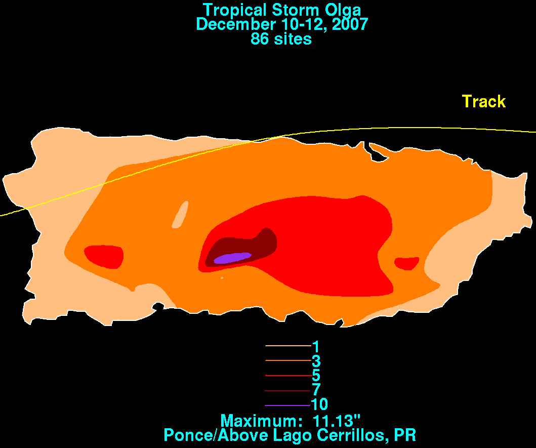 The cyclone dropped light to moderate precipitation across Puerto Rico
, peaking at 11.13 inches (283 mm) near Ponce
. The rainfall increased levels along several rivers across the island, including the Arecibo Big River which was reported at several feet above flood stage. Its passage left about 79,000 people without power and 144,000 without water. In the northern portion of the island, the rainfall caused a mudslides that buried an automobile, which killed its driver.
Heavy rainfall fell across the Dominican Republic
, with isolated totals of 10 inches (250 mm) expected. The rainfall caused flooding along the Yaque del Norte River
, and initially there appeared to be a threat that the Tavera Dam
along the river would fail, potentially killing thousands in Santiago Province. Officials instead opted to open all six floodgates at 0400 UTC on December 12, which released about 1.6 million gallons (6.1 million liters) of water into the river every second. The deluge created a 66 foot (20 m) wave of water that caught many off guard due to the time of night and only about 15 minutes to prepare, according to eyewitnesses who criticized the decision; the flooding killed at least 35 people and left homes in seven towns flooded. Two other deaths were reported elsewhere in the country, and more than 34,000 people fled their homes due to the storm; more than 7,500 houses were damaged. Damage in the country was estimated at $1.5 billion (2007 DOP
, $45 million 2007 USD). In neighboring Haiti
, two deaths were reported in the northern portion of the country. On December 11, a station in the Turks and Caicos Islands
recorded sustained winds of 36 mph (58 km/h).
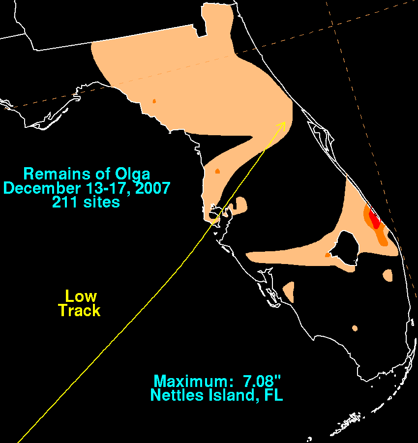
While still moving through the western Caribbean sea, heavy rains fell along a trough in its northeast quadrant beginning on December 14, with a total of 7.08 inches/179.8 mm falling at Nettles Island, Florida. The remnant low intensified due to occasional convection forming near and northeast of the center as it approached the Sunshine State. Clearwater Beach recorded a pressure as low as 1002 mb as well as sustained winds reaching 45 mph (72 km/h), with gusts to 78 mph (126 km/h) between 4 and 5 on the morning of December 16. As a cold front approached, the low pressure area became ill-defined and dissipated before reaching Florida's Space Coast
.
2007 Atlantic hurricane season
The 2007 Atlantic hurricane season was an active Atlantic hurricane season that produced 17 tropical cyclones, 15 tropical storms, six hurricanes, and two major hurricanes. It officially started on June 1 and ended on November 30, dates which conventionally delimit the...
. In the second week of December, after the official end of the hurricane season, a low developed east of the northernmost Lesser Antilles
Lesser Antilles
The Lesser Antilles are a long, partly volcanic island arc in the Western Hemisphere. Most of its islands form the eastern boundary of the Caribbean Sea with the Atlantic Ocean, with the remainder located in the southern Caribbean just north of South America...
. It slowly acquired tropical characteristics, and late on December 10, the NHC declared it Subtropical Storm Olga while just north of Puerto Rico
Puerto Rico
Puerto Rico , officially the Commonwealth of Puerto Rico , is an unincorporated territory of the United States, located in the northeastern Caribbean, east of the Dominican Republic and west of both the United States Virgin Islands and the British Virgin Islands.Puerto Rico comprises an...
. It is the first post-season storm since Tropical Storm Zeta
Tropical Storm Zeta (2005)
Tropical Storm Zeta was a late-developing tropical storm over the central Atlantic which formed after the 2005 Atlantic hurricane season had officially ended , and continued into January 2006...
in the 2005 season
2005 Atlantic hurricane season
The 2005 Atlantic hurricane season was the most active Atlantic hurricane season in recorded history, repeatedly shattering numerous records. The impact of the season was widespread and ruinous with an estimated 3,913 deaths and record damage of about $159.2 billion...
, making the 2007 season one of the few with activity both before
Subtropical Storm Andrea (2007)
Subtropical Storm Andrea was the first named storm and first subtropical cyclone of the 2007 Atlantic hurricane season. It developed out of a previously non-tropical low on May 9 about 150 miles northeast of Daytona Beach, Florida, three weeks before the official start of the season...
and after the official bounds of the hurricane season. Olga was only one of a few out of season landfalls, and was the deadliest post-season storm in the Atlantic Basin, with 40 deaths. The storm made landfall on December 11 on the eastern tip of the Dominican Republic
Dominican Republic
The Dominican Republic is a nation on the island of La Hispaniola, part of the Greater Antilles archipelago in the Caribbean region. The western third of the island is occupied by the nation of Haiti, making Hispaniola one of two Caribbean islands that are shared by two countries...
. Later that evening, Olga transitioned into a tropical storm just after making landfall. Olga tracked over Hispaniola
Hispaniola
Hispaniola is a major island in the Caribbean, containing the two sovereign states of the Dominican Republic and Haiti. The island is located between the islands of Cuba to the west and Puerto Rico to the east, within the hurricane belt...
and emerged in the Caribbean Sea
Caribbean Sea
The Caribbean Sea is a sea of the Atlantic Ocean located in the tropics of the Western hemisphere. It is bounded by Mexico and Central America to the west and southwest, to the north by the Greater Antilles, and to the east by the Lesser Antilles....
. Strong wind shear
Wind shear
Wind shear, sometimes referred to as windshear or wind gradient, is a difference in wind speed and direction over a relatively short distance in the atmosphere...
and dry air caused Olga to weaken into a remnant low early on December 13.
The storm impacted many areas affected by Tropical Storm Noel
Hurricane Noel
The name Noel has been used for three tropical cyclones in the Atlantic Ocean.* 1995's Hurricane Noel - reached hurricane strength far from land and was absorbed by a cold front without threatening land....
a month earlier. In Puerto Rico, moderate rainfall caused one death. 37 fatalities were confirmed in the Dominican Republic, including twenty deaths due to the release of floodgates at a dam in Santiago Province. Two deaths were also reported in Haiti
Haiti
Haiti , officially the Republic of Haiti , is a Caribbean country. It occupies the western, smaller portion of the island of Hispaniola, in the Greater Antillean archipelago, which it shares with the Dominican Republic. Ayiti was the indigenous Taíno or Amerindian name for the island...
.
Meteorological history
In the first week of December, a westward-moving upper-level low led to the formation of a broad surface trough well to the east of the northern Lesser AntillesLesser Antilles
The Lesser Antilles are a long, partly volcanic island arc in the Western Hemisphere. Most of its islands form the eastern boundary of the Caribbean Sea with the Atlantic Ocean, with the remainder located in the southern Caribbean just north of South America...
. With a strong ridge
Ridge (meteorology)
A ridge is an elongated region of relatively high atmospheric pressure, the opposite of a trough....
to its northeast, the trough tracked slowly westward, producing scattered convection and some cyclonic turning. On December 8 convection began to persist in association with the trough and an upper-level low. Early on December 9, officials at the Tropical Prediction Center began classifying the system using the Hebert-Poteat technique, and several tropical cyclone forecast models anticipated its development of tropical characteristics
Tropical cyclogenesis
Tropical cyclogenesis is the term that describes the development and strengthening of a tropical cyclone in the atmosphere. The mechanisms through which tropical cyclogenesis occurs are distinctly different from those through which mid-latitude cyclogenesis occurs...
. The system, which consisted of a sharp trough with an area of gale force winds to its north, continued westward through an area of moderately warm sea surface temperatures. On December 10 a low-level circulation developed within the system, though its convection had become disorganized and well-removed from the center. Southerly wind shear
Wind shear
Wind shear, sometimes referred to as windshear or wind gradient, is a difference in wind speed and direction over a relatively short distance in the atmosphere...
left the structure asymmetric, and convection steadily increased closer to the center. With an upper-level low situated just south of the center, the National Hurricane Center
National Hurricane Center
The National Hurricane Center , located at Florida International University in Miami, Florida, is the division of the National Weather Service responsible for tracking and predicting weather systems within the tropics between the Prime Meridian and the 140th meridian west poleward to the 30th...
classified it as Subtropical Storm Olga at 0300 UTC
Coordinated Universal Time
Coordinated Universal Time is the primary time standard by which the world regulates clocks and time. It is one of several closely related successors to Greenwich Mean Time. Computer servers, online services and other entities that rely on having a universally accepted time use UTC for that purpose...
on December 11 while located about 55 miles (85 km) east of San Juan, Puerto Rico
San Juan, Puerto Rico
San Juan , officially Municipio de la Ciudad Capital San Juan Bautista , is the capital and most populous municipality in Puerto Rico, an unincorporated territory of the United States. As of the 2010 census, it had a population of 395,326 making it the 46th-largest city under the jurisdiction of...
.
Subtropical cyclone
A subtropical cyclone is a weather system that has some characteristics of a tropical and an extratropical cyclone. As early as the 1950s, meteorologists were unclear whether they should be characterized as tropical or extratropical cyclones. They were officially recognized by the National...
, Olga maintained well-defined outflow
Outflow (meteorology)
Outflow, in meteorology, is air that flows outwards from a storm system. It is associated with ridging, or anticyclonic flow. In the low levels of the troposphere, outflow radiates from thunderstorms in the form of a wedge of rain-cooled air, which is visible as a thin rope-like cloud on weather...
, and located to the southeast of a strong ridge over the western Atlantic Ocean, the cyclone tracked west-southwestward. The storm strengthened slightly while paralleling the north coast of Puerto Rico
Puerto Rico
Puerto Rico , officially the Commonwealth of Puerto Rico , is an unincorporated territory of the United States, located in the northeastern Caribbean, east of the Dominican Republic and west of both the United States Virgin Islands and the British Virgin Islands.Puerto Rico comprises an...
, and after an increase in convection near the center, Olga made landfall
Landfall (meteorology)
Landfall is the event of a tropical cyclone or a waterspout coming onto land after being over water. When a waterspout makes landfall it is reclassified as a tornado, which can then cause damage inland...
near Punta Cana
Punta Cana
Punta Cana is part of the newly created Punta Cana-Bávaro-Veron-Macao municipal district in La Altagracia, the easternmost province of the Dominican Republic. The area is best known for its beaches and balnearios, which face both the Caribbean and Atlantic, and it has been a popular tourist...
, Dominican Republic
Dominican Republic
The Dominican Republic is a nation on the island of La Hispaniola, part of the Greater Antilles archipelago in the Caribbean region. The western third of the island is occupied by the nation of Haiti, making Hispaniola one of two Caribbean islands that are shared by two countries...
at 1800 UTC on December 11. A Hurricane Hunters
Hurricane Hunters
The Hurricane Hunters are aircraft that fly into tropical cyclones in the North Atlantic Ocean and Northeastern Pacific Ocean for the specific purpose of directly measuring weather data in and around those storms. In the United States, the Air Force, Navy, and NOAA units have all participated in...
flight into the storm reported a tighter wind gradient and peak winds of 60 mph (95 km/h), and at 0000 UTC on December 12 the National Hurricane Center reclassified Olga as a tropical cyclone
Tropical cyclone
A tropical cyclone is a storm system characterized by a large low-pressure center and numerous thunderstorms that produce strong winds and heavy rain. Tropical cyclones strengthen when water evaporated from the ocean is released as the saturated air rises, resulting in condensation of water vapor...
while it was still inland. Convection rapidly weakened as the storm crossed central Hispaniola
Hispaniola
Hispaniola is a major island in the Caribbean, containing the two sovereign states of the Dominican Republic and Haiti. The island is located between the islands of Cuba to the west and Puerto Rico to the east, within the hurricane belt...
, and upon reaching the Caribbean Sea
Caribbean Sea
The Caribbean Sea is a sea of the Atlantic Ocean located in the tropics of the Western hemisphere. It is bounded by Mexico and Central America to the west and southwest, to the north by the Greater Antilles, and to the east by the Lesser Antilles....
the system lacked the convection required for the classification of a tropical cyclone; rainbands well to its northeast maintained stronger winds, though the center became ill-defined with dry air and strong wind shear. Late on December 12, convection increased slightly over the center, though by that time the cyclone weakened to tropical depression status. As significant convection failed to persist, the National Hurricane Center discontinued advisories on Olga earlier on December 13 while located about 80 miles (130 km) northwest of Kingston
Kingston, Jamaica
Kingston is the capital and largest city of Jamaica, located on the southeastern coast of the island. It faces a natural harbour protected by the Palisadoes, a long sand spit which connects the town of Port Royal and the Norman Manley International Airport to the rest of the island...
.
Its remnants continued west-northwestward with a clear low-level circulation, producing scattered thunderstorms over Cuba
Cuba
The Republic of Cuba is an island nation in the Caribbean. The nation of Cuba consists of the main island of Cuba, the Isla de la Juventud, and several archipelagos. Havana is the largest city in Cuba and the country's capital. Santiago de Cuba is the second largest city...
and the Cayman Islands
Cayman Islands
The Cayman Islands is a British Overseas Territory and overseas territory of the European Union located in the western Caribbean Sea. The territory comprises the three islands of Grand Cayman, Cayman Brac, and Little Cayman, located south of Cuba and northwest of Jamaica...
with its moisture extending northward into southern Florida
Florida
Florida is a state in the southeastern United States, located on the nation's Atlantic and Gulf coasts. It is bordered to the west by the Gulf of Mexico, to the north by Alabama and Georgia and to the east by the Atlantic Ocean. With a population of 18,801,310 as measured by the 2010 census, it...
. A small cluster of deep convection developed just east of the center, and the low-level circulation remained well-defined as it approached the coast of the Yucatán Peninsula
Yucatán Peninsula
The Yucatán Peninsula, in southeastern Mexico, separates the Caribbean Sea from the Gulf of Mexico, with the northern coastline on the Yucatán Channel...
. The remnants of Olga turned northward into the Gulf of Mexico
Gulf of Mexico
The Gulf of Mexico is a partially landlocked ocean basin largely surrounded by the North American continent and the island of Cuba. It is bounded on the northeast, north and northwest by the Gulf Coast of the United States, on the southwest and south by Mexico, and on the southeast by Cuba. In...
as a cold front
Cold front
A cold front is defined as the leading edge of a cooler mass of air, replacing a warmer mass of air.-Development of cold front:The cooler and denser air wedges under the less-dense warmer air, lifting it...
approached the center from the northwest. Late on December 16 and early on December 17, the low intensified as it approached the west coast of Florida, with sustained winds of tropical storm force, and gusts to hurricane force, being reported at Clearwater Beach
Clearwater Beach
Clearwater Beach is a resort area located on the Gulf of Mexico in Pinellas County on the west central coast of Florida in the United States. It is a part of the city of Clearwater. The geographic latitude is 27.57 N and longitude 82.48 W...
. Ultimately, the approaching cold front
Cold front
A cold front is defined as the leading edge of a cooler mass of air, replacing a warmer mass of air.-Development of cold front:The cooler and denser air wedges under the less-dense warmer air, lifting it...
absorbed the low as it moved across the Florida
Florida
Florida is a state in the southeastern United States, located on the nation's Atlantic and Gulf coasts. It is bordered to the west by the Gulf of Mexico, to the north by Alabama and Georgia and to the east by the Atlantic Ocean. With a population of 18,801,310 as measured by the 2010 census, it...
peninsula. The cold front was associated with a powerful winter storm
Mid-December 2007 North American Winter storms
The Mid-December 2007 North American Winter storms was a series of winter storms that affected much of central and eastern North America from December 8 to December 18, 2007. The systems affected areas from Oklahoma to Newfoundland and Labrador with freezing rain, thunderstorms, sleet, snow,...
that affected much of Eastern America during that weekend and killed at least 25 across six US states and three Canadian provinces tapped Olga's moisture, drawing it northeastward mainly offshore the East Coast.
Preparations
On December 10, the Tropical Prediction Center issued a gale warning for waters north of the Lesser AntillesLesser Antilles
The Lesser Antilles are a long, partly volcanic island arc in the Western Hemisphere. Most of its islands form the eastern boundary of the Caribbean Sea with the Atlantic Ocean, with the remainder located in the southern Caribbean just north of South America...
, Puerto Rico
Puerto Rico
Puerto Rico , officially the Commonwealth of Puerto Rico , is an unincorporated territory of the United States, located in the northeastern Caribbean, east of the Dominican Republic and west of both the United States Virgin Islands and the British Virgin Islands.Puerto Rico comprises an...
, and the Dominican Republic
Dominican Republic
The Dominican Republic is a nation on the island of La Hispaniola, part of the Greater Antilles archipelago in the Caribbean region. The western third of the island is occupied by the nation of Haiti, making Hispaniola one of two Caribbean islands that are shared by two countries...
, in association with the precursor disturbance to Olga. Upon it being classified as a subtropical cyclone, the government of the Dominican Republic issued a tropical storm warning
Tropical cyclone warnings and watches
Warnings and watches are two levels of alert issued by national weather forecasting bodies to coastal areas threatened by the imminent approach of a tropical cyclone of tropical storm or hurricane intensity. They are notices to the local population and civil authorities to make appropriate...
from Cabo Engaño
Cabo Engaño
Cabo Engaño is the easternmost point of the island of Hispaniola, on the territory of the Dominican Republic. Punta Cana International Airport, the nation's busiest, lies slightly south of the cape....
along the north coast to its border with Haiti
Haiti
Haiti , officially the Republic of Haiti , is a Caribbean country. It occupies the western, smaller portion of the island of Hispaniola, in the Greater Antillean archipelago, which it shares with the Dominican Republic. Ayiti was the indigenous Taíno or Amerindian name for the island...
; a tropical storm watch was also issued along the southern coastline to near Santo Domingo
Santo Domingo
Santo Domingo, known officially as Santo Domingo de Guzmán, is the capital and largest city in the Dominican Republic. Its metropolitan population was 2,084,852 in 2003, and estimated at 3,294,385 in 2010. The city is located on the Caribbean Sea, at the mouth of the Ozama River...
. Because winds were well to the north of its center, a tropical storm warning was not issued for Puerto Rico. Prior to it moving ashore, the government of Haiti issued a tropical storm warning for its northern coastline, and later a tropical storm warning was issued for the Turks and Caicos Islands, as well as the southeastern Bahamas
The Bahamas
The Bahamas , officially the Commonwealth of the Bahamas, is a nation consisting of 29 islands, 661 cays, and 2,387 islets . It is located in the Atlantic Ocean north of Cuba and Hispaniola , northwest of the Turks and Caicos Islands, and southeast of the United States...
.
The San Juan National Weather Service
National Weather Service
The National Weather Service , once known as the Weather Bureau, is one of the six scientific agencies that make up the National Oceanic and Atmospheric Administration of the United States government...
office issued a flood watch for all of Puerto Rico, including the islands of Culebra
Culebra, Puerto Rico
Isla Culebra is an island-municipality of Puerto Rico originally called Isla Pasaje and Isla de San Ildefonso. It is located approximately east of the Puerto Rican mainland, west of St. Thomas and north of Vieques. Culebra is spread over 5 wards and Culebra Pueblo...
and Vieques
Vieques, Puerto Rico
Vieques , in full Isla de Vieques, is an island–municipality of Puerto Rico in the northeastern Caribbean, part of an island grouping sometimes known as the Spanish Virgin Islands...
. Extended periods of heavy rainfall also resulted in flash flood warnings for portions across the island. Ferry service between Fajardo
Fajardo, Puerto Rico
Fajardo is a small city in Puerto Rico located in the east region of the island, bordering the Atlantic Ocean, north of Ceiba and east of Luquillo.Fajardo is spread over 7 wards and Downtown Fajardo , which serves as the administrative center of the city...
and the islands of Culebra and Vieques was temporarily suspended during the passage of the storm. In the Dominican Republic, officials opened shelters in 15 provinces, with citizens in low-lying areas recommended to stay elsewhere during the passage of the storm; citizens in 22 communities were evacuated.
Impact
Puerto Rico
Puerto Rico , officially the Commonwealth of Puerto Rico , is an unincorporated territory of the United States, located in the northeastern Caribbean, east of the Dominican Republic and west of both the United States Virgin Islands and the British Virgin Islands.Puerto Rico comprises an...
, peaking at 11.13 inches (283 mm) near Ponce
Ponce, Puerto Rico
Ponce is both a city and a municipality in the southern part of Puerto Rico. The city is the seat of the municipal government.The city of Ponce, the fourth most populated in Puerto Rico, and the most populated outside of the San Juan metropolitan area, is named for Juan Ponce de León y Loayza, the...
. The rainfall increased levels along several rivers across the island, including the Arecibo Big River which was reported at several feet above flood stage. Its passage left about 79,000 people without power and 144,000 without water. In the northern portion of the island, the rainfall caused a mudslides that buried an automobile, which killed its driver.
Heavy rainfall fell across the Dominican Republic
Dominican Republic
The Dominican Republic is a nation on the island of La Hispaniola, part of the Greater Antilles archipelago in the Caribbean region. The western third of the island is occupied by the nation of Haiti, making Hispaniola one of two Caribbean islands that are shared by two countries...
, with isolated totals of 10 inches (250 mm) expected. The rainfall caused flooding along the Yaque del Norte River
Yaque del Norte River
The Yaque Del Norte River is the longest river in the Dominican Republic. The river rises in the centre of the country to the south of Santiago city in Santiago province. The river runs roughly due north, through Santiago, before turning west-north-west through the Cibao Valley. It enters the...
, and initially there appeared to be a threat that the Tavera Dam
Hydroelectricity and dams in the Dominican Republic
There are numerous hydroelectric plants in the Dominican Republic, which is composed of rivers, lakes, streams, and numerous waterfalls.The main rivers in the Dominican Republic are the Yaque del Norte, which is the longest in the country at 201 km in length...
along the river would fail, potentially killing thousands in Santiago Province. Officials instead opted to open all six floodgates at 0400 UTC on December 12, which released about 1.6 million gallons (6.1 million liters) of water into the river every second. The deluge created a 66 foot (20 m) wave of water that caught many off guard due to the time of night and only about 15 minutes to prepare, according to eyewitnesses who criticized the decision; the flooding killed at least 35 people and left homes in seven towns flooded. Two other deaths were reported elsewhere in the country, and more than 34,000 people fled their homes due to the storm; more than 7,500 houses were damaged. Damage in the country was estimated at $1.5 billion (2007 DOP
Dominican peso
The Dominican peso, also called peso oro is the currency of the Dominican Republic. Its symbol is "$", with "RD$" used when distinction from other pesos is required; its ISO 4217 code is "DOP". Each peso is divided into 100 centavos , for which the ¢ symbol is used...
, $45 million 2007 USD). In neighboring Haiti
Haiti
Haiti , officially the Republic of Haiti , is a Caribbean country. It occupies the western, smaller portion of the island of Hispaniola, in the Greater Antillean archipelago, which it shares with the Dominican Republic. Ayiti was the indigenous Taíno or Amerindian name for the island...
, two deaths were reported in the northern portion of the country. On December 11, a station in the Turks and Caicos Islands
Turks and Caicos Islands
The Turks and Caicos Islands are a British Overseas Territory and overseas territory of the European Union consisting of two groups of tropical islands in the Caribbean, the larger Caicos Islands and the smaller Turks Islands, known for tourism and as an offshore financial centre.The Turks and...
recorded sustained winds of 36 mph (58 km/h).
While still moving through the western Caribbean sea, heavy rains fell along a trough in its northeast quadrant beginning on December 14, with a total of 7.08 inches/179.8 mm falling at Nettles Island, Florida. The remnant low intensified due to occasional convection forming near and northeast of the center as it approached the Sunshine State. Clearwater Beach recorded a pressure as low as 1002 mb as well as sustained winds reaching 45 mph (72 km/h), with gusts to 78 mph (126 km/h) between 4 and 5 on the morning of December 16. As a cold front approached, the low pressure area became ill-defined and dissipated before reaching Florida's Space Coast
Space Coast
The Space Coast is a region in the U.S. state of Florida around Kennedy Space Center , where NASA launched space shuttles until the last one on July 8th, 2011 at 11:29am; and Cape Canaveral Air Force Station, site of unmanned civilian and military space launches...
.
See also
- Other storms of the same nameTropical Storm OlgaThe name Olga has been used for two tropical cyclone in the Atlantic Basin and ten tropical cyclones in the Pacific Ocean.Olga is used on the six-year lists in the Atlantic, where it replaced Opal:...
- List of off-season Atlantic hurricanes