
.gif)
Tropical Depression Ten (2007)
Encyclopedia
Tropical Depression Ten was a short-lived tropical cyclone
that made landfall
on the Florida Panhandle
in September 2007. The system developed as a subtropical depression
on September 21 in the northeastern Gulf of Mexico
from the interaction of a tropical wave
, the tail end of a cold front
, and an upper-level low
. Initially containing a poorly defined circulation and intermittent thunderstorm activity, the system transitioned into a tropical depression after convection
increased over the center. Tracking northwestward, the depression moved ashore near Fort Walton Beach
early on September 22, and shortly thereafter it dissipated over southeastern Alabama
.
Initially the depression was forecast to move ashore as a minimal tropical storm, and the threat of the depression prompted state of emergency declarations in Mississippi and Louisiana. It was the first tropical cyclone to threaten the New Orleans area since Hurricane Katrina
and the destructive 2005 hurricane season
. Overall impact from the cyclone was minor and largely limited to light rainfall. However, the precursor system spawned a damaging tornado in Eustis, Florida
, where 20 houses were destroyed and 30 more were damaged.
, a tropical wave
that produced Tropical Storm Ingrid, and the tail end of a cold front
. By September 17, the system produced widespread thunderstorm activity over the Bahamas and western Atlantic Ocean
. The upper-level low
over the Florida Panhandle
increased convection
across the area, and on September 18 the system began crossing Florida
. Initially very disorganized, surface pressures gradually decreased across the region, with a weak low pressure area
developing on September 19.
A reconnaissance aircraft
flight into the system on September 20 reported a well-defined low and strong wind gusts in squall
s as the system tracked into the northeastern Gulf of Mexico
, along with limited and disorganized thunderstorm activity. Convection gradually became better organized, with a well-defined band in its eastern semicircle and intermittent thunderstorm activity near the center. Despite an overall disorganized structure, with a poorly defined circulation and an upper-level low aloft, the National Hurricane Center
initiated advisories on Subtropical Depression Ten at 1500 UTC
on September 21 while it was located about 40 miles (60 km) south of St. Vincent Island, Florida
, citing "the potential for additional development right along the coastline." In post-analysis, it was classified a subtropical cyclone three hours earlier.
With a mid-level ridge
to its northwest, the subtropical depression
was anticipated to parallel the coastline of the Gulf Coast of the United States
. As a result, it was forecast to attain winds of 45 mph (75 km/h) and move ashore along southern Mississippi
. The circulation became better defined as convection modestly increased over the center, and within six hours of its development the system transitioned
into a tropical depression. The cyclone continued tracking northwestward, making landfall around 0000 UTC on September 22 near Fort Walton Beach, Florida
with winds of 35 mph (55 km/h). The cloud pattern deteriorated as it tracked inland, and 3 hours after it moved ashore the National Hurricane Center issued its last advisory on the depression. As the depression tracked into Alabama
, it became increasingly disorganized, and the system dissipated as a tropical cyclone early on September 22. Its remnant surface low continued west-northwest before dissipating near the Louisiana
/Texas
border early on September 23.
.jpg) The combination of wind shear
The combination of wind shear
and low-level helicity
produced moderate convection across central Florida
in association with the precursor low pressure system. Late on September 20, a supercell
developed near Lake Apopka
, and tracking quickly northward it spawned an EF1
tornado
near Eustis
; the tornado tracked about 2 miles (3 km) and reached winds of about 100 mph (160 km/h). The tornado destroyed 20 homes, left 30 others severely damaged, injured one person, and caused power outages for about 300 people. Damage totaled $6.2 million (2007 USD). Tornadoes were also reported near Marianna
and Chipley
. The precursor low pressure system also generated lightning
that stuck and killed a man in Hendry County, Florida
.
Outer rainbands began affecting coastal sections of the Florida Panhandle
by about 12 hours prior to the formation of the depression. Coinciding with the first advisory on the depression, the National Hurricane Center
issued a tropical storm warning
from Apalachicola, Florida
westward to the mouth of the Mississippi River
. Shortly thereafter, an inland tropical storm warning was issued for Pearl River
, Walthall
, and Pike counties
in Mississippi
and Washington Parish
in Louisiana
. Additionally, the New Orleans National Weather Service
issued a coastal flood watch for four parishes in southeastern Louisiana. In Mississippi
, Governor Haley Barbour
declared a state of emergency. Officials ordered a mandatory evacuation for residents in shallow areas and in mobile homes for Jackson
, Harrison
, and Hancock counties
. Officials in New Orleans opened three emergency shelters, citing the potential need of shelter for citizens in about 17,000 FEMA trailer
s after Hurricane Katrina
. Due to the threat of the cyclone, Louisiana governor Kathleen Blanco
declared a state of emergency and placed the state's National Guard and other disaster services on reserve.
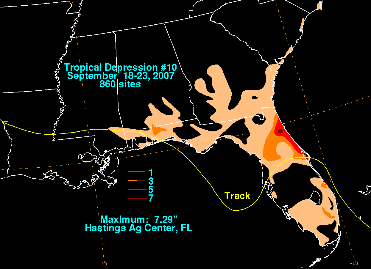 Waves of about 5 feet (1.5 m) and rip currents were reported along the west coast of Florida. However, no beach erosion was reported. Rainfall associated with the system peaked at 7.29 inches (185 mm) at Hastings
. Elsewhere, rainfall totals reached 1.46 inches (37.1 mm) in Albany, Georgia
and 0.51 inches (13 mm) in Dothan, Alabama
. Wind gusts from the storm peaked at 46 mph (74 km/h) in Milton, Florida
, which blew town a few trees in Escambia County
. Overall damage from the depression was minimal. Storm surge
ranged from 2.5 to 4.1 ft (0.762 to 1.2 m) along the Panhandle.
Prior to its development, several oil and gas companies removed unneeded workers from offshore oil platforms in the northern Gulf of Mexico; Shell Oil Company
evacuated about 700 employees, while Noble Energy
removed its workforce of about 300 people from two oil rigs. Exxon Mobil cut its output by about 1,000 barrels of oil and 55000 ft3. With 27.7% of the daily crude oil production halted due to the depression, oil prices rose further after days of increasing levels, and on September 20 reached a record rate of over $84 per barrel.
Tropical cyclone
A tropical cyclone is a storm system characterized by a large low-pressure center and numerous thunderstorms that produce strong winds and heavy rain. Tropical cyclones strengthen when water evaporated from the ocean is released as the saturated air rises, resulting in condensation of water vapor...
that made landfall
Landfall (meteorology)
Landfall is the event of a tropical cyclone or a waterspout coming onto land after being over water. When a waterspout makes landfall it is reclassified as a tornado, which can then cause damage inland...
on the Florida Panhandle
Florida Panhandle
The Florida Panhandle, an informal, unofficial term for the northwestern part of Florida, is a strip of land roughly 200 miles long and 50 to 100 miles wide , lying between Alabama on the north and the west, Georgia also on the north, and the Gulf of Mexico to the south. Its eastern boundary is...
in September 2007. The system developed as a subtropical depression
Subtropical cyclone
A subtropical cyclone is a weather system that has some characteristics of a tropical and an extratropical cyclone. As early as the 1950s, meteorologists were unclear whether they should be characterized as tropical or extratropical cyclones. They were officially recognized by the National...
on September 21 in the northeastern Gulf of Mexico
Gulf of Mexico
The Gulf of Mexico is a partially landlocked ocean basin largely surrounded by the North American continent and the island of Cuba. It is bounded on the northeast, north and northwest by the Gulf Coast of the United States, on the southwest and south by Mexico, and on the southeast by Cuba. In...
from the interaction of a tropical wave
Tropical wave
Tropical waves, easterly waves, or tropical easterly waves, also known as African easterly waves in the Atlantic region, are a type of atmospheric trough, an elongated area of relatively low air pressure, oriented north to south, which move from east to west across the tropics causing areas of...
, the tail end of a cold front
Cold front
A cold front is defined as the leading edge of a cooler mass of air, replacing a warmer mass of air.-Development of cold front:The cooler and denser air wedges under the less-dense warmer air, lifting it...
, and an upper-level low
Low pressure area
A low-pressure area, or "low", is a region where the atmospheric pressure at sea level is below that of surrounding locations. Low-pressure systems form under areas of wind divergence which occur in upper levels of the troposphere. The formation process of a low-pressure area is known as...
. Initially containing a poorly defined circulation and intermittent thunderstorm activity, the system transitioned into a tropical depression after convection
Atmospheric convection
Atmospheric convection is the result of a parcel-environment instability, or temperature difference, layer in the atmosphere. Different lapse rates within dry and moist air lead to instability. Mixing of air during the day which expands the height of the planetary boundary layer leads to...
increased over the center. Tracking northwestward, the depression moved ashore near Fort Walton Beach
Fort Walton Beach, Florida
Fort Walton Beach is a city in southern Okaloosa County, Florida, United States. As of 2005, the population estimate for Fort Walton Beach was 19,992, and as of 2010, the population estimate for Fort Walton Beach is 19,507 recorded by the U.S. Census Bureau...
early on September 22, and shortly thereafter it dissipated over southeastern Alabama
Alabama
Alabama is a state located in the southeastern region of the United States. It is bordered by Tennessee to the north, Georgia to the east, Florida and the Gulf of Mexico to the south, and Mississippi to the west. Alabama ranks 30th in total land area and ranks second in the size of its inland...
.
Initially the depression was forecast to move ashore as a minimal tropical storm, and the threat of the depression prompted state of emergency declarations in Mississippi and Louisiana. It was the first tropical cyclone to threaten the New Orleans area since Hurricane Katrina
Hurricane Katrina
Hurricane Katrina of the 2005 Atlantic hurricane season was a powerful Atlantic hurricane. It is the costliest natural disaster, as well as one of the five deadliest hurricanes, in the history of the United States. Among recorded Atlantic hurricanes, it was the sixth strongest overall...
and the destructive 2005 hurricane season
2005 Atlantic hurricane season
The 2005 Atlantic hurricane season was the most active Atlantic hurricane season in recorded history, repeatedly shattering numerous records. The impact of the season was widespread and ruinous with an estimated 3,913 deaths and record damage of about $159.2 billion...
. Overall impact from the cyclone was minor and largely limited to light rainfall. However, the precursor system spawned a damaging tornado in Eustis, Florida
Eustis, Florida
Eustis is a city in Lake County, Florida, United States. The population was 15,106 at the 2000 census. The Census Bureau estimated the population in 2008 to be 19,129. It is part of the Orlando–Kissimmee Metropolitan Statistical Area.-Geography:...
, where 20 houses were destroyed and 30 more were damaged.
Meteorological history
Tropical Depression Ten formed from the complex interaction between an upper-level lowLow pressure area
A low-pressure area, or "low", is a region where the atmospheric pressure at sea level is below that of surrounding locations. Low-pressure systems form under areas of wind divergence which occur in upper levels of the troposphere. The formation process of a low-pressure area is known as...
, a tropical wave
Tropical wave
Tropical waves, easterly waves, or tropical easterly waves, also known as African easterly waves in the Atlantic region, are a type of atmospheric trough, an elongated area of relatively low air pressure, oriented north to south, which move from east to west across the tropics causing areas of...
that produced Tropical Storm Ingrid, and the tail end of a cold front
Cold front
A cold front is defined as the leading edge of a cooler mass of air, replacing a warmer mass of air.-Development of cold front:The cooler and denser air wedges under the less-dense warmer air, lifting it...
. By September 17, the system produced widespread thunderstorm activity over the Bahamas and western Atlantic Ocean
Atlantic Ocean
The Atlantic Ocean is the second-largest of the world's oceanic divisions. With a total area of about , it covers approximately 20% of the Earth's surface and about 26% of its water surface area...
. The upper-level low
Low pressure area
A low-pressure area, or "low", is a region where the atmospheric pressure at sea level is below that of surrounding locations. Low-pressure systems form under areas of wind divergence which occur in upper levels of the troposphere. The formation process of a low-pressure area is known as...
over the Florida Panhandle
Florida Panhandle
The Florida Panhandle, an informal, unofficial term for the northwestern part of Florida, is a strip of land roughly 200 miles long and 50 to 100 miles wide , lying between Alabama on the north and the west, Georgia also on the north, and the Gulf of Mexico to the south. Its eastern boundary is...
increased convection
Convection
Convection is the movement of molecules within fluids and rheids. It cannot take place in solids, since neither bulk current flows nor significant diffusion can take place in solids....
across the area, and on September 18 the system began crossing Florida
Florida
Florida is a state in the southeastern United States, located on the nation's Atlantic and Gulf coasts. It is bordered to the west by the Gulf of Mexico, to the north by Alabama and Georgia and to the east by the Atlantic Ocean. With a population of 18,801,310 as measured by the 2010 census, it...
. Initially very disorganized, surface pressures gradually decreased across the region, with a weak low pressure area
Low pressure area
A low-pressure area, or "low", is a region where the atmospheric pressure at sea level is below that of surrounding locations. Low-pressure systems form under areas of wind divergence which occur in upper levels of the troposphere. The formation process of a low-pressure area is known as...
developing on September 19.
A reconnaissance aircraft
Hurricane Hunters
The Hurricane Hunters are aircraft that fly into tropical cyclones in the North Atlantic Ocean and Northeastern Pacific Ocean for the specific purpose of directly measuring weather data in and around those storms. In the United States, the Air Force, Navy, and NOAA units have all participated in...
flight into the system on September 20 reported a well-defined low and strong wind gusts in squall
Squall
A squall is a sudden, sharp increase in wind speed which is usually associated with active weather, such as rain showers, thunderstorms, or heavy snow. Squalls refer to an increase in the sustained winds over a short time interval, as there may be higher gusts during a squall event...
s as the system tracked into the northeastern Gulf of Mexico
Gulf of Mexico
The Gulf of Mexico is a partially landlocked ocean basin largely surrounded by the North American continent and the island of Cuba. It is bounded on the northeast, north and northwest by the Gulf Coast of the United States, on the southwest and south by Mexico, and on the southeast by Cuba. In...
, along with limited and disorganized thunderstorm activity. Convection gradually became better organized, with a well-defined band in its eastern semicircle and intermittent thunderstorm activity near the center. Despite an overall disorganized structure, with a poorly defined circulation and an upper-level low aloft, the National Hurricane Center
National Hurricane Center
The National Hurricane Center , located at Florida International University in Miami, Florida, is the division of the National Weather Service responsible for tracking and predicting weather systems within the tropics between the Prime Meridian and the 140th meridian west poleward to the 30th...
initiated advisories on Subtropical Depression Ten at 1500 UTC
Coordinated Universal Time
Coordinated Universal Time is the primary time standard by which the world regulates clocks and time. It is one of several closely related successors to Greenwich Mean Time. Computer servers, online services and other entities that rely on having a universally accepted time use UTC for that purpose...
on September 21 while it was located about 40 miles (60 km) south of St. Vincent Island, Florida
St. Vincent Island, Florida
St. Vincent Island is the western-most of 4 barrier islands in the northwestern Florida Gulf coast which include Cape St. George Island, St. George Island and Dog Island. St. Vincent Island is located just offshore in Franklin County, Florida south southeast of Cape San Blas and north of Cape St...
, citing "the potential for additional development right along the coastline." In post-analysis, it was classified a subtropical cyclone three hours earlier.
With a mid-level ridge
Ridge (meteorology)
A ridge is an elongated region of relatively high atmospheric pressure, the opposite of a trough....
to its northwest, the subtropical depression
Subtropical cyclone
A subtropical cyclone is a weather system that has some characteristics of a tropical and an extratropical cyclone. As early as the 1950s, meteorologists were unclear whether they should be characterized as tropical or extratropical cyclones. They were officially recognized by the National...
was anticipated to parallel the coastline of the Gulf Coast of the United States
Gulf Coast of the United States
The Gulf Coast of the United States, sometimes referred to as the Gulf South, South Coast, or 3rd Coast, comprises the coasts of American states that are on the Gulf of Mexico, which includes Texas, Louisiana, Mississippi, Alabama, and Florida and are known as the Gulf States...
. As a result, it was forecast to attain winds of 45 mph (75 km/h) and move ashore along southern Mississippi
Mississippi
Mississippi is a U.S. state located in the Southern United States. Jackson is the state capital and largest city. The name of the state derives from the Mississippi River, which flows along its western boundary, whose name comes from the Ojibwe word misi-ziibi...
. The circulation became better defined as convection modestly increased over the center, and within six hours of its development the system transitioned
Tropical cyclogenesis
Tropical cyclogenesis is the term that describes the development and strengthening of a tropical cyclone in the atmosphere. The mechanisms through which tropical cyclogenesis occurs are distinctly different from those through which mid-latitude cyclogenesis occurs...
into a tropical depression. The cyclone continued tracking northwestward, making landfall around 0000 UTC on September 22 near Fort Walton Beach, Florida
Fort Walton Beach, Florida
Fort Walton Beach is a city in southern Okaloosa County, Florida, United States. As of 2005, the population estimate for Fort Walton Beach was 19,992, and as of 2010, the population estimate for Fort Walton Beach is 19,507 recorded by the U.S. Census Bureau...
with winds of 35 mph (55 km/h). The cloud pattern deteriorated as it tracked inland, and 3 hours after it moved ashore the National Hurricane Center issued its last advisory on the depression. As the depression tracked into Alabama
Alabama
Alabama is a state located in the southeastern region of the United States. It is bordered by Tennessee to the north, Georgia to the east, Florida and the Gulf of Mexico to the south, and Mississippi to the west. Alabama ranks 30th in total land area and ranks second in the size of its inland...
, it became increasingly disorganized, and the system dissipated as a tropical cyclone early on September 22. Its remnant surface low continued west-northwest before dissipating near the Louisiana
Louisiana
Louisiana is a state located in the southern region of the United States of America. Its capital is Baton Rouge and largest city is New Orleans. Louisiana is the only state in the U.S. with political subdivisions termed parishes, which are local governments equivalent to counties...
/Texas
Texas
Texas is the second largest U.S. state by both area and population, and the largest state by area in the contiguous United States.The name, based on the Caddo word "Tejas" meaning "friends" or "allies", was applied by the Spanish to the Caddo themselves and to the region of their settlement in...
border early on September 23.
Preparations and impact
Wind shear
Wind shear, sometimes referred to as windshear or wind gradient, is a difference in wind speed and direction over a relatively short distance in the atmosphere...
and low-level helicity
Helicity (fluid mechanics)
In fluid mechanics, helicity is the extent to which helix-like motion occurs. If a parcel of fluid is moving, undergoing solid body motion rotating about an axis parallel to the direction of motion, it will have helicity...
produced moderate convection across central Florida
Florida
Florida is a state in the southeastern United States, located on the nation's Atlantic and Gulf coasts. It is bordered to the west by the Gulf of Mexico, to the north by Alabama and Georgia and to the east by the Atlantic Ocean. With a population of 18,801,310 as measured by the 2010 census, it...
in association with the precursor low pressure system. Late on September 20, a supercell
Supercell
A supercell is a thunderstorm that is characterized by the presence of a mesocyclone: a deep, continuously-rotating updraft. For this reason, these storms are sometimes referred to as rotating thunderstorms...
developed near Lake Apopka
Lake Apopka
Lake Apopka is the third largest lake in the U.S. state of Florida. It is located northwest of Orlando, mostly within the bounds of Orange County, although the western part is in Lake County. Fed by a natural spring, rainfall and stormwater runoff, water from Lake Apopka flows through the...
, and tracking quickly northward it spawned an EF1
Enhanced Fujita Scale
The Enhanced Fujita Scale rates the strength of tornadoes in the United States based on the damage they cause.Implemented in place of the Fujita scale introduced in 1971 by Ted Fujita, it began operational use on February 1, 2007. The scale has the same basic design as the original Fujita scale:...
tornado
Tornado
A tornado is a violent, dangerous, rotating column of air that is in contact with both the surface of the earth and a cumulonimbus cloud or, in rare cases, the base of a cumulus cloud. They are often referred to as a twister or a cyclone, although the word cyclone is used in meteorology in a wider...
near Eustis
Eustis, Florida
Eustis is a city in Lake County, Florida, United States. The population was 15,106 at the 2000 census. The Census Bureau estimated the population in 2008 to be 19,129. It is part of the Orlando–Kissimmee Metropolitan Statistical Area.-Geography:...
; the tornado tracked about 2 miles (3 km) and reached winds of about 100 mph (160 km/h). The tornado destroyed 20 homes, left 30 others severely damaged, injured one person, and caused power outages for about 300 people. Damage totaled $6.2 million (2007 USD). Tornadoes were also reported near Marianna
Marianna, Florida
Marianna is a city in Jackson County, Florida, United States. The population was 6,230 at the 2000 census. As of 2004, the population estimated by the U.S. Census Bureau is 6,200 . It is the county seat of Jackson County and is home to Chipola College...
and Chipley
Chipley, Florida
Chipley is a city in Washington County, Florida, United States. Its population was 3,592 at the time of the 2000 U.S. Census. According to the United States Census Bureau estimates of 2005, the city had a population of about 3,682...
. The precursor low pressure system also generated lightning
Lightning
Lightning is an atmospheric electrostatic discharge accompanied by thunder, which typically occurs during thunderstorms, and sometimes during volcanic eruptions or dust storms...
that stuck and killed a man in Hendry County, Florida
Hendry County, Florida
Hendry County is a county located in the U.S. state of Florida. As of 2000, the population was 36,210. The U.S. Census Bureau 2007 estimate for the county is 39,611 . Its county seat is La Belle. The county comprises the Clewiston, Florida, Micropolitan Statistical Area.-History:Hendry County...
.
Outer rainbands began affecting coastal sections of the Florida Panhandle
Florida Panhandle
The Florida Panhandle, an informal, unofficial term for the northwestern part of Florida, is a strip of land roughly 200 miles long and 50 to 100 miles wide , lying between Alabama on the north and the west, Georgia also on the north, and the Gulf of Mexico to the south. Its eastern boundary is...
by about 12 hours prior to the formation of the depression. Coinciding with the first advisory on the depression, the National Hurricane Center
National Hurricane Center
The National Hurricane Center , located at Florida International University in Miami, Florida, is the division of the National Weather Service responsible for tracking and predicting weather systems within the tropics between the Prime Meridian and the 140th meridian west poleward to the 30th...
issued a tropical storm warning
Tropical cyclone warnings and watches
Warnings and watches are two levels of alert issued by national weather forecasting bodies to coastal areas threatened by the imminent approach of a tropical cyclone of tropical storm or hurricane intensity. They are notices to the local population and civil authorities to make appropriate...
from Apalachicola, Florida
Apalachicola, Florida
Apalachicola is a city in Franklin County, Florida, on US 98 about southwest of Tallahassee. The population was 2,334 at the 2000 census. The 2005 census estimated the city's population at 2,340...
westward to the mouth of the Mississippi River
Mississippi River
The Mississippi River is the largest river system in North America. Flowing entirely in the United States, this river rises in western Minnesota and meanders slowly southwards for to the Mississippi River Delta at the Gulf of Mexico. With its many tributaries, the Mississippi's watershed drains...
. Shortly thereafter, an inland tropical storm warning was issued for Pearl River
Pearl River County, Mississippi
-National protected areas:*Bogue Chitto National Wildlife Refuge *De Soto National Forest -Demographics:The census estimates of 2006 place the county population over 57,000 and place it among the 10 fastest growing counties in the U.S. As of the census of 2000, there were 48,621 people, 18,078...
, Walthall
Walthall County, Mississippi
-Demographics:As of the census of 2000, there were 15,156 people, 5,571 households, and 4,111 families residing in the county. The population density was 38 people per square mile . There were 6,418 housing units at an average density of 16 per square mile...
, and Pike counties
Pike County, Mississippi
-Demographics:As of the census of 2000, there were 38,940 people, 14,792 households, and 10,502 families residing in the county. The population density was 95 people per square mile . There were 16,720 housing units at an average density of 41 per square mile...
in Mississippi
Mississippi
Mississippi is a U.S. state located in the Southern United States. Jackson is the state capital and largest city. The name of the state derives from the Mississippi River, which flows along its western boundary, whose name comes from the Ojibwe word misi-ziibi...
and Washington Parish
Washington Parish, Louisiana
Washington Parish is a parish located in the U.S. state of Louisiana. Its parish seat is Franklinton. In 2000, its population was 43,926....
in Louisiana
Louisiana
Louisiana is a state located in the southern region of the United States of America. Its capital is Baton Rouge and largest city is New Orleans. Louisiana is the only state in the U.S. with political subdivisions termed parishes, which are local governments equivalent to counties...
. Additionally, the New Orleans National Weather Service
National Weather Service
The National Weather Service , once known as the Weather Bureau, is one of the six scientific agencies that make up the National Oceanic and Atmospheric Administration of the United States government...
issued a coastal flood watch for four parishes in southeastern Louisiana. In Mississippi
Mississippi
Mississippi is a U.S. state located in the Southern United States. Jackson is the state capital and largest city. The name of the state derives from the Mississippi River, which flows along its western boundary, whose name comes from the Ojibwe word misi-ziibi...
, Governor Haley Barbour
Haley Barbour
Haley Reeves Barbour is an American Republican politician currently serving as the 63rd Governor of Mississippi. He gained a national spotlight in August 2005 after Mississippi was hit by Hurricane Katrina. Barbour won re-election as Governor in 2007...
declared a state of emergency. Officials ordered a mandatory evacuation for residents in shallow areas and in mobile homes for Jackson
Jackson County, Mississippi
There were 47,676 households out of which 37.00% had children under the age of 18 living with them, 55.70% were married couples living together, 14.50% had a female householder with no husband present, and 25.10% were non-families. 20.80% of all households were made up of individuals and 7.10% had...
, Harrison
Harrison County, Mississippi
-National protected areas:* De Soto National Forest * Gulf Islands National Seashore - Demographics :As of the census of 2000, there were 189,601 people, 71,538 households, and 48,574 families residing in the county. The population density was 326 people per square mile . There were 79,636 housing...
, and Hancock counties
Hancock County, Mississippi
-Demographics:As of the census of 2000, there were 42,967 people, 16,897 households, and 11,827 families residing in the county. The population density was 90 people per square mile . There were 21,072 housing units at an average density of 44 per square mile...
. Officials in New Orleans opened three emergency shelters, citing the potential need of shelter for citizens in about 17,000 FEMA trailer
FEMA trailer
The term FEMA trailer,or FEMA travel trailer, is the name commonly given by the United States Government to many forms of temporary manufactured housing assigned to the victims of Hurricane Katrina, Hurricane Rita or other events, by the Federal Emergency Management Agency...
s after Hurricane Katrina
Hurricane Katrina
Hurricane Katrina of the 2005 Atlantic hurricane season was a powerful Atlantic hurricane. It is the costliest natural disaster, as well as one of the five deadliest hurricanes, in the history of the United States. Among recorded Atlantic hurricanes, it was the sixth strongest overall...
. Due to the threat of the cyclone, Louisiana governor Kathleen Blanco
Kathleen Blanco
Kathleen Babineaux Blanco was the 54th Governor of Louisiana, having served from January 2004 until January 2008. She was the first woman to be elected to the office of governor of Louisiana....
declared a state of emergency and placed the state's National Guard and other disaster services on reserve.
Hastings, Florida
Hastings is a town and agricultural center in St. Johns County, Florida, United States, southwest of St. Augustine. The population was 521 at the 2000 census. As of 2004, the population recorded by the U.S. Census Bureau was 607.-History:...
. Elsewhere, rainfall totals reached 1.46 inches (37.1 mm) in Albany, Georgia
Albany, Georgia
Albany is a city in and the county seat of Dougherty County, Georgia, United States, in the southwestern part of the state. It is the principal city of the Albany, Georgia metropolitan area and the southwest part of the state. The population was 77,434 at the 2010 U.S. Census, making it the...
and 0.51 inches (13 mm) in Dothan, Alabama
Dothan, Alabama
Dothan is a city located in the southeastern corner of the US state of Alabama, situated approximately west of the Georgia state line and north of Florida. It is the seat of Houston County, with portions extending into nearby Dale County and Henry County...
. Wind gusts from the storm peaked at 46 mph (74 km/h) in Milton, Florida
Milton, Florida
Milton , or Milltown, because Milton had the largest mill around) is a city in Santa Rosa County, Florida, United States. The city was incorporated in 1844 and is home to Naval Air Station Whiting Field. The population was 7,045 at the 2000 census. In 2004, the population recorded by the U.S...
, which blew town a few trees in Escambia County
Escambia County, Florida
Escambia County is the westernmost county in the U.S. state of Florida. The 2010 population was 297,619. The U.S. Census Bureau 2005 estimate for the county is 296,772. Its county seat is Pensacola.- History :...
. Overall damage from the depression was minimal. Storm surge
Storm surge
A storm surge is an offshore rise of water associated with a low pressure weather system, typically tropical cyclones and strong extratropical cyclones. Storm surges are caused primarily by high winds pushing on the ocean's surface. The wind causes the water to pile up higher than the ordinary sea...
ranged from 2.5 to 4.1 ft (0.762 to 1.2 m) along the Panhandle.
Prior to its development, several oil and gas companies removed unneeded workers from offshore oil platforms in the northern Gulf of Mexico; Shell Oil Company
Shell Oil Company
Shell Oil Company is the United States-based subsidiary of Royal Dutch Shell, a multinational oil company of Anglo Dutch origins, which is amongst the largest oil companies in the world. Approximately 22,000 Shell employees are based in the U.S. The head office in the U.S. is in Houston, Texas...
evacuated about 700 employees, while Noble Energy
Noble Energy
Noble Energy, Inc. of Houston, Texas, United States is the modern name of Noble Affiliates Inc., by which it was known through the 1990s, and it is now an oil and natural gas exploration and production company with almost US$3 billion in revenue at #660 on the 2007 Fortune 1000 list of the largest...
removed its workforce of about 300 people from two oil rigs. Exxon Mobil cut its output by about 1,000 barrels of oil and 55000 ft3. With 27.7% of the daily crude oil production halted due to the depression, oil prices rose further after days of increasing levels, and on September 20 reached a record rate of over $84 per barrel.
Tornadoes
| List of confirmed tornadoes – Thursday, September 20, 2007 | ||||||
|---|---|---|---|---|---|---|
Enhanced Fujita Scale The Enhanced Fujita Scale rates the strength of tornadoes in the United States based on the damage they cause.Implemented in place of the Fujita scale introduced in 1971 by Ted Fujita, it began operational use on February 1, 2007. The scale has the same basic design as the original Fujita scale:... |
|
|
|
|
|
|
| Florida Florida Florida is a state in the southeastern United States, located on the nation's Atlantic and Gulf coasts. It is bordered to the west by the Gulf of Mexico, to the north by Alabama and Georgia and to the east by the Atlantic Ocean. With a population of 18,801,310 as measured by the 2010 census, it... |
||||||
| EF1 | Eustis Eustis, Florida Eustis is a city in Lake County, Florida, United States. The population was 15,106 at the 2000 census. The Census Bureau estimated the population in 2008 to be 19,129. It is part of the Orlando–Kissimmee Metropolitan Statistical Area.-Geography:... area |
Lake Lake County, Florida Lake County is a county located in the state of Florida, United States. As of the 2000 Census, the population was 210,528. The Census Bureau estimated the population in 2008 to be 307,243. Its county seat is Tavares... |
28.84°N 81.68°W | 0257 | 1.8 miles (2.9 km) | Brief touchdown, with the tornado destroying 20 homes, causing serious damage to 30 others, and minor damage to an additional 81 homes. Left $6.2 million in damages. |
| EF1 | W of Mayo Mayo, Florida Mayo is a town and the only municipality in Lafayette County, Florida, United States. The population was 988 at the 2000 census. As of 2004, the population recorded by the U.S. Census Bureau is 1,009... |
Lafayette Lafayette County, Florida Lafayette County is a county located in the state of Florida. As of 2000, the population was 7,022. It is the second least populated county in the state, having one more resident, according to the 2000 census, than Liberty County, Florida. The U.S. Census Bureau 2005 estimate for the county is... |
30.05°N 83.25°W | 0420 | 0.3 mile (0.482802 km) | Brief touchdown; the tornado uprooted large oak trees with debris on State Highway 53 and County Road 351. Caused $2,000 in damages. |
| List of confirmed tornadoes – Friday, September 21, 2007 | ||||||
| Georgia Georgia (U.S. state) Georgia is a state located in the southeastern United States. It was established in 1732, the last of the original Thirteen Colonies. The state is named after King George II of Great Britain. Georgia was the fourth state to ratify the United States Constitution, on January 2, 1788... |
||||||
| EF0 | ENE of Waresboro Waresboro, Georgia Waresboro is an unincorporated community in Ware County, Georgia, United States. It is located west of Waycross. The community is part of the Waycross Micropolitan Statistical Area... |
Ware Ware County, Georgia Ware County is a county located in the southeast of the U.S. state of Georgia. As of 2000, the population was 35,483. The 2007 Census Estimate shows a population of 35,831 The county seat is Waycross.... |
31.25°N 82.47°W | 0845 | 0.6 mile (0.965604 km) | Brief touchdown, with 12 structures suffering slight to moderate damage to roofs and skirting. Most damaged structures were mobile homes and outbuildings. A few trees and power lines were also blown down. |
| Alabama Alabama Alabama is a state located in the southeastern region of the United States. It is bordered by Tennessee to the north, Georgia to the east, Florida and the Gulf of Mexico to the south, and Mississippi to the west. Alabama ranks 30th in total land area and ranks second in the size of its inland... |
||||||
| EF0 | W of Blue Springs Blue Springs, Alabama Blue Springs is a town in Barbour County, Alabama, United States. At the 2000 census the population was 121. According to the 2005 U.S. Census estimates, the town had a population of 118. -Geography:... |
Barbour Barbour County, Alabama Barbour County, Alabama is a county of the U.S. state of Alabama. Its name is in honor of James Barbour, who served as Governor of Virginia. As of 2010 the population was 27,457. Its county seat is Clayton.-History:... |
31.66°N 85.57°W | 2234 | 0.4 mile (0.643736 km) | Brief touchdown, a Sheriff's Deputy reported a tornado near the intersection of County Route 23 and County Route 8, just southeast of Clio. The Deputy observed debris, but there was no subsequent damage found. |
| Sources: NCDC Tornado database files |
||||||
See also
- List of Florida hurricanes (2000-present)
- Timeline of the 2007 Atlantic hurricane seasonTimeline of the 2007 Atlantic hurricane seasonThis timeline documents all the storm formations, strengthening, weakening, landfalls, extratropical transitions, as well as dissipation during the 2007 Atlantic hurricane season. The season officially began on June 1, 2007, and ended on November 30, although Subtropical Storm Andrea and Tropical...
- List of storms in the 2007 Atlantic hurricane season