
Stafford County, Kansas
Encyclopedia
Stafford County is a county
located in the U.S. state
of Kansas
. As of the 2010 census, the county population was 4,437. Its county seat
is St. John
. The county is named in memory of Lewis Stafford, captain of Company E, First Kansas Infantry, who was killed at the Battle of Young's Point, Madison Parrish, Louisiana, June 7, 1863.
, county.
 As of the census
of 2000, there were 4,789 people, 2,010 households, and 1,294 families residing in the county. The population density
was 6 people per square mile (2/km²). There were 2,458 housing units at an average density of 3 per square mile (1/km²). The racial makeup of the county was 94.97% White
, 0.15% Black
or African American
, 0.38% Native American
, 0.13% Asian
, 2.97% from other races
, and 1.42% from two or more races. 5.41% of the population were Hispanic
or Latino
of any race.
There were 2,010 households out of which 29.90% had children under the age of 18 living with them, 55.90% were married couples
living together, 5.90% had a female householder with no husband present, and 35.60% were non-families. 33.00% of all households were made up of individuals and 17.20% had someone living alone who was 65 years of age or older. The average household size was 2.34 and the average family size was 2.99.
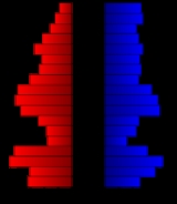
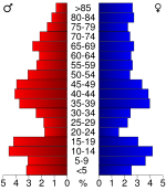
In the county the population was spread out with 26.30% under the age of 18, 5.40% from 18 to 24, 24.60% from 25 to 44, 22.50% from 45 to 64, and 21.20% who were 65 years of age or older. The median age was 41 years. For every 100 females there were 95.20 males. For every 100 females age 18 and over, there were 91.40 males.
The median income for a household in the county was $31,107, and the median income for a family was $38,235. Males had a median income of $27,328 versus $21,063 for females. The per capita income
for the county was $16,409. About 8.70% of families and 11.80% of the population were below the poverty line, including 15.20% of those under age 18 and 8.90% of those age 65 or over.
. None of the cities within the county are considered governmentally independent, and all figures for the townships include those of the cities. In the following table, the population center is the largest city (or cities) included in that township's population total, if it is of a significant size.
General Information
Kansas County Data
Stafford County local history and genealogy
Maps
County (United States)
In the United States, a county is a geographic subdivision of a state , usually assigned some governmental authority. The term "county" is used in 48 of the 50 states; Louisiana is divided into parishes and Alaska into boroughs. Parishes and boroughs are called "county-equivalents" by the U.S...
located in the U.S. state
U.S. state
A U.S. state is any one of the 50 federated states of the United States of America that share sovereignty with the federal government. Because of this shared sovereignty, an American is a citizen both of the federal entity and of his or her state of domicile. Four states use the official title of...
of Kansas
Kansas
Kansas is a US state located in the Midwestern United States. It is named after the Kansas River which flows through it, which in turn was named after the Kansa Native American tribe, which inhabited the area. The tribe's name is often said to mean "people of the wind" or "people of the south...
. As of the 2010 census, the county population was 4,437. Its county seat
County seat
A county seat is an administrative center, or seat of government, for a county or civil parish. The term is primarily used in the United States....
is St. John
St. John, Kansas
St. John is a city in and the county seat of Stafford County, Kansas, United States. As of the 2010 census, the city population was 1,295.-19th century:...
. The county is named in memory of Lewis Stafford, captain of Company E, First Kansas Infantry, who was killed at the Battle of Young's Point, Madison Parrish, Louisiana, June 7, 1863.
19th century
The boundaries of Stafford County were defined by the Kansas Legislature of 1870 but for several years, the county remained unorganized. The Legislature of 1875, with the intention of obliterating the county from the map, gave the territory in Stafford County to other counties. They gave the portion in Range 15 West to Pawnee County; the portion included in Ranges 11, 12, 13 and 14 to Barton County; and the south half of the county, excepting the portion in Range 15, was added to Pratt County. But after each of the counties had taken its part, a strip six miles wide and twelve miles long (two townships) remained as Stafford County. This was the condition of the county until April 25, 1879, when, by a decision of the Supreme Court, the act of the Legislature dividing the county was declared unconstitutional and the county was restored to its original boundaries.Law and government
Although the Kansas Constitution was amended in 1986 to allow the sale of alcoholic liquor by the individual drink with the approval of voters, Stafford County has remained a prohibition, or "dry"Dry county
A dry county is a county in the United States whose government forbids the sale of alcoholic beverages. Some prohibit off-premises sale, some prohibit on-premises sale, and some prohibit both. Hundreds of dry counties exist across the United States, almost all of them in the South...
, county.
Geography
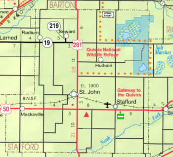
According to the 2000 census, the county has a total area of 794.72 square miles (2,058.3 km²), of which 792.05 square miles (2,051.4 km²) (or 99.66%) is land and 2.67 square miles (6.9 km²) (or 0.34%) is water.Adjacent counties
- Barton CountyBarton County, KansasBarton County is a county located in Western Kansas, in the Central United States. As of the 2010 census, the county population was 27,674. Its county seat and most populous city is Great Bend. The county is named in honor of Clara Barton, responsible for the founding of the American Red Cross...
(north) - Rice CountyRice County, KansasRice County is a county located in the U.S. state of Kansas; it was named in memory of Samuel Allen Rice, Brigadier-General, United States volunteers, killed April 30, 1864, at Jenkins Ferry, Arkansas. As of the 2010 census, the county population was 10,083...
(northeast) - Reno CountyReno County, KansasReno County is a county located in the U.S. state of Kansas. The county's population was 64,511 for the 2010 census. The largest city and county seat is Hutchinson. The Hutchinson Micropolitan Statistical Area includes all of Reno County.-19th century:In 1887, the Chicago, Kansas and Nebraska...
(east) - Pratt CountyPratt County, KansasPratt County is a county located in the U.S. state of Kansas. As of the 2010 census, the county population was 9,656. The largest city and county seat is Pratt.-19th century:...
(south) - Edwards CountyEdwards County, KansasEdwards County is a county located in Southwest Kansas, in the Central United States. As of the 2010 census, the county population was 3,037...
(west) - Pawnee CountyPawnee County, KansasPawnee County is a county located in the U.S. state of Kansas. As of the 2010 census, the county population was 6,973...
(west)
Demographics
Census
A census is the procedure of systematically acquiring and recording information about the members of a given population. It is a regularly occurring and official count of a particular population. The term is used mostly in connection with national population and housing censuses; other common...
of 2000, there were 4,789 people, 2,010 households, and 1,294 families residing in the county. The population density
Population density
Population density is a measurement of population per unit area or unit volume. It is frequently applied to living organisms, and particularly to humans...
was 6 people per square mile (2/km²). There were 2,458 housing units at an average density of 3 per square mile (1/km²). The racial makeup of the county was 94.97% White
Race (United States Census)
Race and ethnicity in the United States Census, as defined by the Federal Office of Management and Budget and the United States Census Bureau, are self-identification data items in which residents choose the race or races with which they most closely identify, and indicate whether or not they are...
, 0.15% Black
Race (United States Census)
Race and ethnicity in the United States Census, as defined by the Federal Office of Management and Budget and the United States Census Bureau, are self-identification data items in which residents choose the race or races with which they most closely identify, and indicate whether or not they are...
or African American
Race (United States Census)
Race and ethnicity in the United States Census, as defined by the Federal Office of Management and Budget and the United States Census Bureau, are self-identification data items in which residents choose the race or races with which they most closely identify, and indicate whether or not they are...
, 0.38% Native American
Race (United States Census)
Race and ethnicity in the United States Census, as defined by the Federal Office of Management and Budget and the United States Census Bureau, are self-identification data items in which residents choose the race or races with which they most closely identify, and indicate whether or not they are...
, 0.13% Asian
Race (United States Census)
Race and ethnicity in the United States Census, as defined by the Federal Office of Management and Budget and the United States Census Bureau, are self-identification data items in which residents choose the race or races with which they most closely identify, and indicate whether or not they are...
, 2.97% from other races
Race (United States Census)
Race and ethnicity in the United States Census, as defined by the Federal Office of Management and Budget and the United States Census Bureau, are self-identification data items in which residents choose the race or races with which they most closely identify, and indicate whether or not they are...
, and 1.42% from two or more races. 5.41% of the population were Hispanic
Race (United States Census)
Race and ethnicity in the United States Census, as defined by the Federal Office of Management and Budget and the United States Census Bureau, are self-identification data items in which residents choose the race or races with which they most closely identify, and indicate whether or not they are...
or Latino
Race (United States Census)
Race and ethnicity in the United States Census, as defined by the Federal Office of Management and Budget and the United States Census Bureau, are self-identification data items in which residents choose the race or races with which they most closely identify, and indicate whether or not they are...
of any race.
There were 2,010 households out of which 29.90% had children under the age of 18 living with them, 55.90% were married couples
Marriage
Marriage is a social union or legal contract between people that creates kinship. It is an institution in which interpersonal relationships, usually intimate and sexual, are acknowledged in a variety of ways, depending on the culture or subculture in which it is found...
living together, 5.90% had a female householder with no husband present, and 35.60% were non-families. 33.00% of all households were made up of individuals and 17.20% had someone living alone who was 65 years of age or older. The average household size was 2.34 and the average family size was 2.99.
In the county the population was spread out with 26.30% under the age of 18, 5.40% from 18 to 24, 24.60% from 25 to 44, 22.50% from 45 to 64, and 21.20% who were 65 years of age or older. The median age was 41 years. For every 100 females there were 95.20 males. For every 100 females age 18 and over, there were 91.40 males.
The median income for a household in the county was $31,107, and the median income for a family was $38,235. Males had a median income of $27,328 versus $21,063 for females. The per capita income
Per capita income
Per capita income or income per person is a measure of mean income within an economic aggregate, such as a country or city. It is calculated by taking a measure of all sources of income in the aggregate and dividing it by the total population...
for the county was $16,409. About 8.70% of families and 11.80% of the population were below the poverty line, including 15.20% of those under age 18 and 8.90% of those age 65 or over.
Incorporated cities
Name and population (2004 estimate):- St. JohnSt. John, KansasSt. John is a city in and the county seat of Stafford County, Kansas, United States. As of the 2010 census, the city population was 1,295.-19th century:...
, 1,224 (county seat) - StaffordStafford, KansasStafford is a city in Stafford County, Kansas, United States. As of the 2010 census, the city population was 1,042.-Geography:Stafford is located at...
, 1,077 - MacksvilleMacksville, KansasMacksville is a city in Stafford County, Kansas, United States. As of the 2010 census, the city population was 549.-Geography:According to the United States Census Bureau, the city has a total area of , all of it land.-Demographics:...
, 495 - HudsonHudson, KansasHudson is a city in Stafford County, Kansas, United States. As of the 2010 census, the city population was 129.-Geography:Hudson is located at . According to the United States Census Bureau, the city has a total area of , all of it land.-Demographics:As of the census of 2000, there were 133...
, 128 - SewardSeward, KansasSeward is a city in Stafford County, Kansas, United States. As of the 2010 census, the city population was 64.The city should not be confused with the Seward County.-Geography:Seward is located at...
, 61 - RadiumRadium, KansasRadium is a city in Stafford County, Kansas, United States. As of the 2010 census, the city population was 25.-Geography:Radium is located at . According to the United States Census Bureau, the city has a total area of , all of it land.-Demographics:As of the census of 2000, there were 40...
, 38
Townships
Stafford County is divided into twenty-one townshipsCivil township
A civil township is a widely used unit of local government in the United States, subordinate to, and geographic divisions of, a county. Specific responsibilities and the degree of autonomy vary based on each state. Civil townships are distinct from survey townships, but in states that have both,...
. None of the cities within the county are considered governmentally independent, and all figures for the townships include those of the cities. In the following table, the population center is the largest city (or cities) included in that township's population total, if it is of a significant size.
| Township | FIPS | Population center |
Population | Population density /km² (/sq mi) |
Land area km² (sq mi) | Water area km² (sq mi) | Water % | Geographic coordinates |
|---|---|---|---|---|---|---|---|---|
| Albano | 00800 | 56 | 1 (2) | 94 (36) | 0 (0) | 0 % | 37°52′43"N 98°51′43"W | |
| Byron | 09825 | 80 | 1 (2) | 94 (36) | 0 (0) | 0.07% | 38°12′50"N 98°38′7"W | |
| Clear Creek | 13825 | 36 | 0 (1) | 93 (36) | 0 (0) | 0 % | 37°50′57"N 98°57′31"W | |
| Cleveland | 14125 | 68 | 1 (2) | 93 (36) | 0 (0) | 0.04% | 38°2′11"N 98°52′2"W | |
| Douglas | 18375 | 138 | 1 (4) | 93 (36) | 0 (0) | 0 % | 38°8′16"N 98°52′2"W | |
| East Cooper | 19350 | 90 | 1 (3) | 92 (36) | 1 (0) | 0.75% | 38°2′43"N 98°31′6"W | |
| Fairview | 22675 | 98 | 1 (3) | 93 (36) | 0 (0) | 0 % | 37°56′52"N 98°31′4"W | |
| Farmington | 23250 | 591 | 6 (16) | 93 (36) | 0 (0) | 0 % | 37°57′30"N 98°58′2"W | |
| Hayes | 31025 | 212 | 2 (6) | 93 (36) | 0 (0) | 0 % | 38°7′20"N 98°38′49"W | |
| Lincoln | 41225 | 113 | 1 (3) | 93 (36) | 0 (0) | 0.02% | 38°12′38"N 98°52′2"W | |
| North Seward | 51375 | 186 | 2 (5) | 93 (36) | 0 (0) | 0.03% | 38°12′36"N 98°45′27"W | |
| Ohio | 52475 | 409 | 4 (11) | 95 (36) | 0 (0) | 0 % | 37°58′40"N 98°45′7"W | |
| Putnam | 58050 | 19 | 0 (0) | 182 (70) | 5 (2) | 2.91% | 38°10′26"N 98°31′51"W | |
| Richland | 59650 | 70 | 1 (2) | 94 (36) | 0 (0) | 0 % | 37°57′49"N 98°51′12"W | |
| Rose Valley | 61300 | 74 | 1 (2) | 94 (36) | 0 (0) | 0 % | 37°51′41"N 98°44′19"W | |
| St. John | 62300 | 1,037 | 11 (29) | 94 (36) | 0 (0) | 0.07% | 38°0′58"N 98°45′21"W | |
| South Seward | 66975 | 55 | 1 (2) | 93 (36) | 0 (0) | 0.09% | 38°8′11"N 98°44′36"W | |
| Stafford | 67800 | 1,291 | 14 (36) | 93 (36) | 0 (0) | 0 % | 37°57′40"N 98°36′50"W | |
| Union | 72450 | 41 | 0 (1) | 93 (36) | 0 (0) | 0.09% | 37°52′31"N 98°37′40"W | |
| West Cooper | 76875 | 64 | 1 (2) | 93 (36) | 0 (0) | 0.14% | 38°2′37"N 98°38′9"W | |
| York | 80800 | 61 | 1 (2) | 93 (36) | 0 (0) | 0.27% | 37°52′14"N 98°31′9"W |
Education
Unified school districts
See also
- National Register of Historic Places listings in Stafford County, Kansas
Further reading
- History of the State of Kansas; William G. Cutler; A.T. Andreas Publisher; 1883. (Online HTML eBook)
- Kansas : A Cyclopedia of State History, Embracing Events, Institutions, Industries, Counties, Cities, Towns, Prominent Persons, Etc; 3 Volumes; Frank W. Blackmar; Standard Publishing Co; 944 / 955 / 824 pages; 1912. (Volume1 - Download 54MB PDF eBook),(Volume2 - Download 53MB PDF eBook), (Volume3 - Download 33MB PDF eBook)
External links
OfficialGeneral Information
Kansas County Data
Stafford County local history and genealogy
- Kansas State Historical Society
- William G. Cutler's History of the State of Kansas
- Stafford County Historical & Genealogical Society
Maps
- Stafford County Map, KDOT
- Kansas Highway Map, KDOT
- Kansas Railroad Map, KDOT
- Kansas School District Boundary Map, KSDE