
Interstate 69
Encyclopedia
Interstate 69 is an Interstate Highway in the United States
. It exists in two parts: a completed highway from Indianapolis, Indiana
, northeast to the Canadian border in Port Huron, Michigan
, and a mostly proposed extension southwest to the Mexican border in Texas
. Of this extension – nicknamed the NAFTA Superhighway because it would help trade with Canada
and Mexico
spurred by the North American Free Trade Agreement
– only three short pieces—a 6.2 mile (10.0 km) section near Corpus Christi, Texas
, one in northwestern Mississippi
and in the Memphis, Tennessee
area and a 1.73-mile segment near Evansville, Indiana
--have been built and signed as I-69 (see Interstate 69 in Mississippi
and Interstate 69 in Indiana
). A fourth segment of I-69 through Kentucky, 145 miles (232 km) long utilizing that state's existing parkway system and a section of Interstate 24
, was established by federal legislation in 2008, but the Federal Highway Administration did not authorize the parkways to be signed as I-69 until upgrades of certain sections are complete. A 55-mile (88.5 km) section of the previously existing Western Kentucky Parkway
from Eddyville
to Nortonville
was recently approved and signed. .
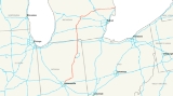
The southern terminus of the original portion is at Interstate 465, the beltway around Indianapolis, on the northeast side of that city. I-69 heads northeast, past Anderson
, Muncie
, Marion
, and Fort Wayne, Indiana
; the latter city is served by Interstate 469
, I-69's only current signed auxiliary route. After crossing the Indiana East-West Toll Road
(I-80/I-90) near Angola
, I-69 enters Michigan, crossing I-94 east of Battle Creek
and joining with I-96 for an overlap west of Lansing
. Where it splits from I-96, I-69 turns east, both in compass direction and in signed direction, and heads north of Lansing and through Flint
(where it crosses I-75) to a junction with I-94 in Port Huron. The last bit of I-69 overlaps I-94 to the Blue Water Bridge
across the St. Clair River
, where traffic continues on Highway 402 in the Canadian province of Ontario
.
The proposed extension evolved from the combination of Corridors 18 and 20 of the National Highway System
as designated in the Intermodal Surface Transportation Efficiency Act
of 1991, but the federally recognized corridor also includes connecting and existing infrastructure, including Interstate 94
between Chicago
and Port Huron and several spurs from I-69. Among these proposed spurs are an extension of Interstate 530 from Pine Bluff, Arkansas
(known as "the Dickey Split," for its champion, congressman Jay Dickey
), an upgrade of U.S. Route 59 from Texarkana, Texas
, and a split in southern Texas to serve three border crossings at Laredo
, Pharr
, and Brownsville
.
In August 2007, I-69 was selected by the USDOT as one of six Corridors of the Future, making it eligible for additional federal funding and streamlined planning and review. When it is finished, it may be one of the longest interstate highways not numbered with a digit ending in 0 or 5 (next to Interstate 94
) and may be the longest north-south interstate highway. If the entire length of the freeway is completed, the freeway will end up being about 1800 miles in length.
to the Blue Water Bridge
at Port Huron, Michigan
, a 1.73 miles (2.8 km) section from I-64/I-164 to Indiana State Road 68
(SR 68) in southwest Indiana, and a 42 miles (67.6 km) section from Tunica Resorts, Mississippi
to the I-40/I-69/TN-300 interchange in Memphis, Tennessee
.
The new I-69 in Mississippi and Tennessee starts at an at-grade intersection with the former route of Mississippi Highway 304 in Banks
, Tunica County
. It continues roughly north-northeast, crossing into DeSoto County
, to a partial interchange with the current route of MS 304, then runs easterly to an interchange with I-55
in northern Hernando
. It then continues north, overlapping I-55 to the Tennessee state line, and continues northward concurrently with I-55 to the south side of Memphis. It then follows I-240 northward through downtown before joining I-40. Presently, the northern end of this section of I-69 is at the I-40/I-69/TN-300 interchange on the north side of Memphis. This portion of the route is the first "section of independent utility" (SUI) of the proposed extension to be signed as part of the national I-69 route, and the first portion designed as part of the extension.
The new section of Interstate 69 in southern Indiana presently begins at the I-64/I-164/SR 57
interchange north of Evansville
, at the boundary between the SIU 3 ["Segment of Independent Utility"] and SIU 4; from there, it runs north to SR 68
. Construction is currently underway to take the route north-northeast from there to Indiana 64
near Oakland City
, which marks the end of Section 1 of SIU 3. NEPA Tier 2 Records of Decision (ROD) have been approved and final design work is presently underway to continue the highway from there north-northeast to US 50/US 150 at Washington
(SIU 3, Section 2) and then on northeast to US 231 near the Crane Naval Surface Warfare Center (SIU 3, Section 3). The Tier 2 Draft Environmental Impact Statement (DEIS) has been published for the final new-terrain segment (SIU 3, Section 4), which will take I-69 from Crane NSWC northeast to SR 37
on the southwest side of Bloomington
. From there, Sections 4 (Bloomington to Martinsville
) and 5 (Martinsville to Indianapolis
) of I-69's SIU 3 will eventually upgrade the existing SR 37 expressway corridor to full Interstate freeway standards all the way north-northeast to I-465
on the southwest side of Indianapolis.
The traditional portion of Interstate 69 in Indiana (SIU 1 of the overall national plan) starts at an interchange with I-465 in northeastern Indianapolis
, running roughly northeast to near Anderson
, where it turns more easterly to provide indirect access to Muncie
before turning more northerly towards Fort Wayne
. In Fort Wayne, I-69 roughly runs along the western edge of the city while an auxiliary route, I-469
, loops east of the city. I-69 continues northerly to the Indiana East-West Toll Road
near Fremont
, then crosses the border into Michigan just south of Kinderhook.
I-69 in Michigan runs north passing through Coldwater
and Marshall
. Near Olivet
, I-69 begins to turn in a northeasterly direction passing through the Lansing metropolitan area. Here I-69 is cosigned on/with I-96
, the only such palindromic
pairing in the Interstate Highway System
. I-69 is signed east–west from Lansing through Flint to Port Huron. At its eastern terminus, I-69 joins I-94
to cross the Blue Water Bridges at the Canadian border over the St. Clair River.
.svg.png) In 2000, Corridors 18 and 20 were split into 32 Segments of Independent Utility (SIUs) as part of the I-69 (Corridor 18) Special Environmental Study. Some states use these SIU numbers to identify projects. I-94 between Chicago and Port Huron was SIU 27.
In 2000, Corridors 18 and 20 were split into 32 Segments of Independent Utility (SIUs) as part of the I-69 (Corridor 18) Special Environmental Study. Some states use these SIU numbers to identify projects. I-94 between Chicago and Port Huron was SIU 27.
, SIU 1 (all of original I-69 north of Indianapolis) and SIU 2 (which will likely use I-465 around Indianapolis, but is as yet unsigned) are open, as is the short SIU 10 in northwestern Mississippi, and part of SIU 9 in the Memphis, Tennessee
area. SIUs 5 and 6 in Kentucky are built as freeways, but not yet up to Interstate standards in all areas. On June 6, 2008, President George W. Bush
signed HR-1195, designating these parkways as I-69. Kentucky officials planned to place I-69 signs on the Pennyrile Parkway
, Western Kentucky Parkway
and Purchase Parkway
in 2008, but the U.S. Federal Highway Administration
(FHA) has not yet given Kentucky approval to do so.
Four SIUs in Indiana, Tennessee, and Arkansas (3, 7, 9, and 28) are under construction and portions of these SIUs are open to traffic. Most of the remaining parts of the mainline are in the environmental impact statement
(EIS) stages; the FHA has signed records of decision approving the final EIS for SIUs 11, 12, and 13.
While federal legislation established a mandate to extend I-69 from Indiana to Texas, it did not provide funding for its construction. Therefore, it must compete against other projects for traditional funding. Despite approval of several segments, work has been completed on only a few scattered segments, due in part to increasing costs for construction materials and machinery. As a result, several states have indicated that construction of I-69 may not be possible without the use of tolls
as the primary means to finance building the highway. Tennessee, Arkansas, and Mississippi passed legislation authorizing toll roads within each state. However, financing I-69 construction with tolls is highly unpopular in most areas; Indiana examined building most of SIU 3 as a toll road
, but quickly reverted to making it toll-free after widespread opposition from I-69 opponents and supporters alike.
In Texas, it was originally envisioned that private firms will build, operate, then transfer
portions of the highway to the state after a specified period of time. Lawmakers in Kentucky considered a bill that would authorize the re-tolling of three parkways slated to become part of I-69. Kentucky and Indiana plan to finance a new bridge across the Ohio River with tolls, and Indiana governor Mitch Daniels announced in 2006 that I-69 through Indiana will be toll-free; about half of I-69 extension through southwest Indiana will be built using $700 million from the 2006 Major Moves
deal, although the Major Moves legislation gives Indiana the option to place tolls on I-69 if necessary.
, I-69 planning has become part of the Trans-Texas Corridor
(TTC) studies. This part of the TTC, called I-69/TTC, includes I-69 and all of its spurs authorized by Congress. It will extend from three border crossings, at Laredo
, McAllen
, and Brownsville
, along US 59, US 281, and US 77 towards Victoria
. After the three branches join, I-69 will continue along the general US 59 corridor past Houston to Carthage
, where it will turn easterly to Louisiana. In metro Houston, I-69 will now follow the US-59 freeway corridor through town. A planned branch continues north on US 59 from the Carthage
area to Texarkana
. Most of the proposed I-69 route in Texas already exists as 4-lane highways, with a lengthy freeway section stretching north and south of Houston along U.S. 59 and shorter freeway sections of U.S. 77, U.S. 83, and U.S. 281 in the Rio Grande Valley.
The I-69/TTC project has been split into 15 SIUs, which match the original ones but do not share numbers. SIUs 1 to 8 (original 16 to 23) cover the main line along the "I-69 East" branch to Brownsville. The "I-69 Central" branch to McAllen is SIUs 9, 11, and 12 (original 24 to 26). The branches to Texarkana and Laredo are SIUs 13 and 14 (original 29 and 30), and two connections near Brownsville are SIUs 10 and 15 (original 31 and 32). The I-69/TTC study also includes SIU L-CC, a connection between Laredo and Corpus Christi
that was not in the 2000 study. The Texas Department of Transportation
(TxDOT) originally considered building the I-69/TTC over new terrain paralleling US-59, US-77, and US-281.
Responding to widespread opposition from environmental groups and property rights activists, TxDOT announced in June 2008 that it will complete I-69 by upgrading the existing US-59, US-77, and US-281 roadways to Interstate standards through rural areas, with bypasses around urban centers along the route. Instead of building the Trans-Texas Corridor as originally planned, TxDOT now plans to finance upgrading the existing highways to I-69 through private sector investment. Under the proposed arrangement, I-69 would remain toll-free where it overlaps pre-existing highways, while bypasses of cities may be tolled. The private firms awarded contracts for I-69 would also build and operate toll roads throughout the state; some of those revenues would then be applied to I-69 construction.
A stated goal of TxDOT's I-69 initiative is that "existing suitable freeway sections of the proposed system be designated as I-69 as soon as possible." In response to TxDOT's request, a six-mile segment of US 77 between I-37
and SH 44 near Corpus Christi
was approved for "I-69" designation by the Federal Highway Administration
in August, 2011, and was approved by the AASHTO in October 2011. Signage will be posted at an official ceremony on December 5, 2011
, SIU 16 also extends into Louisiana
, ending at US 171 near Stonewall
. SIU 15 continues around the south and east sides of the Shreveport
area, crossing I-49 and ending at I-20 near Haughton
. SIU 14 extends northeast from I-20 to US 82 near El Dorado, Arkansas
, and SIU 13 continues northeast to US 65 near McGehee
, mainly paralleling US 278. Also included in Corridor 18, as SIU 28, is an extension of I-530 from Pine Bluff
south along the US 425 corridor to I-69 west of Monticello
; a short piece at the south end opened in mid-2006 as Highway 530. The Charles W. Dean Bridge
, SIU 12, will cross the Mississippi River
between McGehee, Arkansas and Benoit, Mississippi
, while SIU 11 will parallel US 61 to Tunica Resorts
. SIU 10, the first completed portion of the I-69 extension, runs east from Robinsonville to I-55 near Hernando
, and opened in late 2006. With the record of decision signed in 2007, the FHWA authorized MDOT to add I-69 signs on I-55 from the I-55/I-69 interchange in Hernando to the Tennessee state line.
, switching there to I-240 and then I-40 before leaving onto the short State Route 300 connection and then paralleling US 51 to near Millington
. On January 18, 2008, the FHWA authorized TDOT to erect I-69 signs on I-55, I-240, and I-40 from the Mississippi state line to the I-40/TN300 interchange. The proposed Interstate 269
will bypass this part of I-69, beginning where I-69 joins I-55 in Mississippi and ending near Millington, and will include the northern part of State Route 385
near Millington. SIU 8 will continue beyond Millington, near US 51, to I-155 near Dyersburg
, while SIU 7 will use the existing US 51 freeway and new bypasses to the state line at Fulton, Kentucky
.
In Kentucky, I-69 mostly follows existing freeways originally built as toll road
s. SIU 6 follows the Purchase Parkway
and I-24 from Fulton to Eddyville
, while SIU 5 continues along the Wendell H. Ford Western Kentucky Parkway
and Edward T. Breathitt Parkway
(originally called the Pennyrile Parkway) to Henderson
. While these parkways received the I-69 designation by federal legislation signed in 2008, they will require upgrading to meet Interstate standards – but will not need as much work as in other states, where entirely new highways must be built. The interchanges, designed for tollgates (where all ramp traffic must stop), must be replaced. The preferred alternative for SIU 4 will leave the Breathitt Parkway near its north end and cross the Ohio River
to I-164 near Evansville, Indiana
, and will then use I-164 to I-64.
SIU 3, connecting I-64 to I-465 in southern Indianapolis
, will roughly parallel State Road 57
and State Road 45
, and will use an upgraded version of the existing State Road 37
from just south of Bloomington
to a point just south of Indianapolis. The segment from I-64 to Bloomington is currently under construction. Finally, it has long been assumed that SIU 2 will most likely follow I-465 around the city, though INDOT
has never officially confirmed that. The location of an interchange with either I-70 or I-465 has not yet been determined.
On August 31, 2011, Kentucky Governor Steve Beshear
announced an agreement between the state and the Federal Highway Administration
which will allow the Kentucky Transportation Cabinet
to erect I-69 signage along the new interstate's 17-mile overlap with Interstate 24
and the 38-mile stretch of the Wendell H. Ford Western Kentucky Parkway between I-24 and the Edward T. Breathitt Pennyrile Parkway. Signage is expected to be placed in the fall of 2011, with construction on necessary upgrades of the portion of the Western Kentucky Parkway expected to be bid in September. On October 25. 2011, I-69 was officlly designated by Governor Steve Beshear along the Western Kentucky Parkway along a 55 mile stretch between Eddyville, KY and Nortonville, KY.
northeast via Fort Wayne
to I-80/I-90 near Angola
was added to the proposed "Interregional Highway System" by the early 1940s. Unlike most of the routes, it was not drawn along an existing U.S. Highway corridor, except north of Fort Wayne (where it used US 27); most of it ran roughly parallel to State Roads 9
and 37
. The extension beyond Angola to I-94 near Marshall
actually started out as part of what evolved into I-94. On early plans, the Chicago-Detroit route would have replaced US 112
(now US 12
), splitting from I-80/I-90 at South Bend
. By 1947, the route had been shifted north to present I-94, along what was then US 12, but the connection to South Bend remained, splitting at Kalamazoo
.
The Interstate 69 designation was assigned to the Indianapolis-Angola route in 1957, while the short South Bend-Kalamazoo route became proposed Interstate 67. The I-67 designation was shifted east to the US 27 corridor by early 1958, eventually being absorbed into the extension of I-69 to I-94 near Marshall which was built in 1967. The Federal-Aid Highway Act of 1968 authorized an additional 1500 miles (2400 km) of Interstates, to be chosen by the Federal Highway Administration
(FHWA); among Michigan's proposals was a 156-mile (251 km) extension of I-69 northeast and east via US 27 to Lansing
, M-78 to Flint
, and M-21 to Port Huron
. However, the FHWA initially only approved the route to I-475 in Flint. The continuation to Port Huron was eventually approved in late 1984. Michigan's 1241-mile (1997 km) portion of the Interstate system was completed in 1992, when the last piece of I-69 opened southwest of Lansing
between I-96 and Charlotte
.
The Intermodal Surface Transportation Efficiency Act of 1991 included two High Priority Corridors that would later become parts of a proposed cross-country extension of I-69:
Corridor 18 was extended southwest to Houston, Texas
, where it connected to Corridor 20, by the Department of Transportation and Related Agencies Appropriations Act, 1993; the new definition read "Corridor from Indianapolis, Indiana, through Evansville, Indiana, Memphis, Tennessee, Shreveport/Bossier, Louisiana, and to Houston, Texas." The National Highway System Designation Act of 1995 made further amendments to the description of Corridor 18, specifying that it would serve Mississippi
and Arkansas
, extending it south to the Mexican border in the Lower Rio Grande Valley, and adding a short connection at Brownsville, Texas
. This act also specified that Corridors 18 and 20 were "future parts of the Interstate System
", to become actual Interstates when built to Interstate standards and connected to other Interstates. Although the act designated Corridor 9 as Interstate 99
, no number was assigned to Corridors 18 and 20 yet.
The Transportation Equity Act for the 21st Century
(TEA-21), enacted in 1998, greatly expanded the definition of Corridor 18 to include the existing I-69, as well as Interstate 94
between Port Huron and Chicago
. A connection to Pine Bluff, Arkansas
was added, and the extension to the Lower Rio Grande Valley was detailed as splitting into two routes at Victoria
, one following US 77 and the other following US 59 and US 281 to the Rio Grande. This act also assigned the Interstate 69 designation to Corridors 18 and 20, with the branches on US 77 and US 281 to the Rio Grande being "I-69 East" and "I-69 Central". With TEA-21, the I-69 extension took shape, and remains today as those segments.
topography, which environmentalists argue threatens to pollute underground water systems and harm the rare species
that live there.
United States
The United States of America is a federal constitutional republic comprising fifty states and a federal district...
. It exists in two parts: a completed highway from Indianapolis, Indiana
Indianapolis
Indianapolis is the capital of the U.S. state of Indiana, and the county seat of Marion County, Indiana. As of the 2010 United States Census, the city's population is 839,489. It is by far Indiana's largest city and, as of the 2010 U.S...
, northeast to the Canadian border in Port Huron, Michigan
Port Huron, Michigan
Port Huron is a city in the U.S. state of Michigan and the county seat of St. Clair County. The population was 30,184 at the 2010 census. The city is adjacent to Port Huron Township but is administratively autonomous. It is joined by the Blue Water Bridge over the St. Clair River to Sarnia,...
, and a mostly proposed extension southwest to the Mexican border in Texas
Texas
Texas is the second largest U.S. state by both area and population, and the largest state by area in the contiguous United States.The name, based on the Caddo word "Tejas" meaning "friends" or "allies", was applied by the Spanish to the Caddo themselves and to the region of their settlement in...
. Of this extension – nicknamed the NAFTA Superhighway because it would help trade with Canada
Canada
Canada is a North American country consisting of ten provinces and three territories. Located in the northern part of the continent, it extends from the Atlantic Ocean in the east to the Pacific Ocean in the west, and northward into the Arctic Ocean...
and Mexico
Mexico
The United Mexican States , commonly known as Mexico , is a federal constitutional republic in North America. It is bordered on the north by the United States; on the south and west by the Pacific Ocean; on the southeast by Guatemala, Belize, and the Caribbean Sea; and on the east by the Gulf of...
spurred by the North American Free Trade Agreement
North American Free Trade Agreement
The North American Free Trade Agreement or NAFTA is an agreement signed by the governments of Canada, Mexico, and the United States, creating a trilateral trade bloc in North America. The agreement came into force on January 1, 1994. It superseded the Canada – United States Free Trade Agreement...
– only three short pieces—a 6.2 mile (10.0 km) section near Corpus Christi, Texas
Corpus Christi, Texas
Corpus Christi is a coastal city in the South Texas region of the U.S. state of Texas. The county seat of Nueces County, it also extends into Aransas, Kleberg, and San Patricio counties. The MSA population in 2008 was 416,376. The population was 305,215 at the 2010 census making it the...
, one in northwestern Mississippi
Mississippi
Mississippi is a U.S. state located in the Southern United States. Jackson is the state capital and largest city. The name of the state derives from the Mississippi River, which flows along its western boundary, whose name comes from the Ojibwe word misi-ziibi...
and in the Memphis, Tennessee
Memphis, Tennessee
Memphis is a city in the southwestern corner of the U.S. state of Tennessee, and the county seat of Shelby County. The city is located on the 4th Chickasaw Bluff, south of the confluence of the Wolf and Mississippi rivers....
area and a 1.73-mile segment near Evansville, Indiana
Evansville, Indiana
Evansville is the third-largest city in the U.S. state of Indiana and the largest city in Southern Indiana. As of the 2010 census, the city had a total population of 117,429. It is the county seat of Vanderburgh County and the regional hub for both Southwestern Indiana and the...
--have been built and signed as I-69 (see Interstate 69 in Mississippi
Interstate 69 in Mississippi
The proposed Interstate 69 extension from Indianapolis southwest to Texas presently has a short piece completed in the U.S. state of Mississippi, south of Memphis, Tennessee. The south end is an at-grade intersection with the former route of MS 304 near Tunica Resorts, where Mississippi Highway 713...
and Interstate 69 in Indiana
Interstate 69 in Indiana
Interstate 69 presently exists in two discontinuous segments in Indiana. The original highway, completed in November 1971, runs northeast from the state capital of Indianapolis, to the city of Fort Wayne, and then proceeds north to the state of Michigan...
). A fourth segment of I-69 through Kentucky, 145 miles (232 km) long utilizing that state's existing parkway system and a section of Interstate 24
Interstate 24
Interstate 24 is an Interstate Highway in the Midwestern and Southeastern United States. It runs diagonally from Interstate 57 to Chattanooga, Tennessee, at Interstate 75....
, was established by federal legislation in 2008, but the Federal Highway Administration did not authorize the parkways to be signed as I-69 until upgrades of certain sections are complete. A 55-mile (88.5 km) section of the previously existing Western Kentucky Parkway
Western Kentucky Parkway
The Wendell H. Ford Western Kentucky Parkway is a controlled-access highway running from Elizabethtown, Kentucky to near Eddyville, Kentucky. It intersects with Interstate 65 at its eastern terminus, and Interstate 24 at its western terminus. It is one of nine highways that are part of the...
from Eddyville
Eddyville, Kentucky
Eddyville is a city in Lyon County, Kentucky, United States. The population was 2,350 at the 2000 census. It is the county seat of Lyon County . The Kentucky State Penitentiary is located in Eddyville.-History:...
to Nortonville
Nortonville, Kentucky
Nortonville is a city in Hopkins County, Kentucky, United States. The population was 1,264 at the 2000 census.-Geography:Nortonville is located at ....
was recently approved and signed. .
The southern terminus of the original portion is at Interstate 465, the beltway around Indianapolis, on the northeast side of that city. I-69 heads northeast, past Anderson
Anderson, Indiana
Anderson is a city in and the county seat of Madison County, Indiana, United States. It is the principal city of the Anderson, Indiana Metropolitan Statistical Area which encompasses Madison county. Anderson is the headquarters of the Church of God and home of Anderson University, which is...
, Muncie
Muncie, Indiana
Muncie is a city in Center Township, Delaware County in east central Indiana, best known as the home of Ball State University and the birthplace of the Ball Corporation. It is the principal city of the Muncie, Indiana, Metropolitan Statistical Area, which has a population of 118,769...
, Marion
Marion, Indiana
Marion is a city in Grant County, Indiana, United States. The population was 29,948 as of the 2010 census. The city is the county seat of Grant County...
, and Fort Wayne, Indiana
Fort Wayne, Indiana
Fort Wayne is a city in the US state of Indiana and the county seat of Allen County. The population was 253,691 at the 2010 Census making it the 74th largest city in the United States and the second largest in Indiana...
; the latter city is served by Interstate 469
Interstate 469
Interstate 469 is an Interstate Highway in the northeastern portion of the mid-western U.S. state of Indiana. It is an auxiliary route of parent Interstate 69 that also carries portions of US 24, US 30 and US 33 around the urban parts of Fort Wayne, Indiana...
, I-69's only current signed auxiliary route. After crossing the Indiana East-West Toll Road
Indiana Toll Road
The Indiana Toll Road, officially the Indiana East–West Toll Road, is a toll road that runs for east–west across northern Indiana from the Illinois state line to the Ohio state line...
(I-80/I-90) near Angola
Angola, Indiana
Angola is a city in Pleasant Township, Steuben County, Indiana, United States. The population was 8,612 at the 2010 census. The city is the county seat of Steuben County . Angola was founded by Thomas Gale and Cornelius Gilmore. Angola is home to Trine University...
, I-69 enters Michigan, crossing I-94 east of Battle Creek
Battle Creek, Michigan
Battle Creek is a city in the U.S. state of Michigan, in northwest Calhoun County, at the confluence of the Kalamazoo and Battle Creek Rivers. It is the principal city of the Battle Creek, Michigan Metropolitan Statistical Area , which encompasses all of Calhoun county...
and joining with I-96 for an overlap west of Lansing
Lansing, Michigan
Lansing is the capital of the U.S. state of Michigan. It is located mostly in Ingham County, although small portions of the city extend into Eaton County. The 2010 Census places the city's population at 114,297, making it the fifth largest city in Michigan...
. Where it splits from I-96, I-69 turns east, both in compass direction and in signed direction, and heads north of Lansing and through Flint
Flint, Michigan
Flint is a city in the U.S. state of Michigan and is located along the Flint River, northwest of Detroit. The U.S. Census Bureau reports the 2010 population to be placed at 102,434, making Flint the seventh largest city in Michigan. It is the county seat of Genesee County which lies in the...
(where it crosses I-75) to a junction with I-94 in Port Huron. The last bit of I-69 overlaps I-94 to the Blue Water Bridge
Blue Water Bridge
The Blue Water Bridge is a twin-span international bridge across the St. Clair River that links Port Huron, Michigan, USA and Sarnia, Ontario, Canada...
across the St. Clair River
St. Clair River
The St. Clair River is a river in central North America which drains Lake Huron into Lake St Clair, forming part of the international boundary between the Canadian province of Ontario and the U.S. state of Michigan...
, where traffic continues on Highway 402 in the Canadian province of Ontario
Ontario
Ontario is a province of Canada, located in east-central Canada. It is Canada's most populous province and second largest in total area. It is home to the nation's most populous city, Toronto, and the nation's capital, Ottawa....
.
The proposed extension evolved from the combination of Corridors 18 and 20 of the National Highway System
National Highway System (United States)
The National Highway System is a network of strategic highways within the United States, including the Interstate Highway System and other roads serving major airports, ports, rail or truck terminals, railway stations, pipeline terminals and other strategic transport facilities.Individual states...
as designated in the Intermodal Surface Transportation Efficiency Act
Intermodal Surface Transportation Efficiency Act
The Intermodal Surface Transportation Efficiency Act of 1991 is a United States federal law that posed a major change to transportation planning and policy, as the first U.S. federal legislation on the subject in the post-Interstate Highway System era...
of 1991, but the federally recognized corridor also includes connecting and existing infrastructure, including Interstate 94
Interstate 94
Interstate 94 is the northernmost east–west Interstate Highway, connecting the Great Lakes and Intermountain regions of the United States. I-94's western terminus is in Billings, Montana at a junction with Interstate 90; its eastern terminus is the U.S...
between Chicago
Chicago
Chicago is the largest city in the US state of Illinois. With nearly 2.7 million residents, it is the most populous city in the Midwestern United States and the third most populous in the US, after New York City and Los Angeles...
and Port Huron and several spurs from I-69. Among these proposed spurs are an extension of Interstate 530 from Pine Bluff, Arkansas
Pine Bluff, Arkansas
Pine Bluff is the largest city and county seat of Jefferson County, Arkansas, United States. It is also the principal city of the Pine Bluff Metropolitan Statistical Area and part of the Little Rock-North Little Rock-Pine Bluff, Arkansas Combined Statistical Area...
(known as "the Dickey Split," for its champion, congressman Jay Dickey
Jay Dickey
Jay W. Dickey, Jr. is a former U.S. Representative from the Fourth Congressional District of Arkansas. He served in Congress from 1993 to 2000...
), an upgrade of U.S. Route 59 from Texarkana, Texas
Texarkana, Texas
Texarkana is a city in Bowie County, Texas, United States. It effectively functions as one half of a city which crosses a state line — the other half, the city of Texarkana, Arkansas, lies on the other side of State Line Avenue...
, and a split in southern Texas to serve three border crossings at Laredo
Laredo, Texas
Laredo is the county seat of Webb County, Texas, United States, located on the north bank of the Rio Grande in South Texas, across from Nuevo Laredo, Tamaulipas, Mexico. According to the 2010 census, the city population was 236,091 making it the 3rd largest on the United States-Mexican border,...
, Pharr
Pharr, Texas
Pharr is a city in Hidalgo County, Texas, United States. As of the 2010 census, the city population was 70,400. Pharr is connected by bridge to the Mexican city of Reynosa, Tamaulipas...
, and Brownsville
Brownsville, Texas
Brownsville is a city in the southernmost tip of the state of Texas, in the United States. It is located on the northern bank of the Rio Grande, directly north and across the border from Matamoros, Tamaulipas, Mexico. Brownsville is the 16th largest city in the state of Texas with a population of...
.
In August 2007, I-69 was selected by the USDOT as one of six Corridors of the Future, making it eligible for additional federal funding and streamlined planning and review. When it is finished, it may be one of the longest interstate highways not numbered with a digit ending in 0 or 5 (next to Interstate 94
Interstate 94
Interstate 94 is the northernmost east–west Interstate Highway, connecting the Great Lakes and Intermountain regions of the United States. I-94's western terminus is in Billings, Montana at a junction with Interstate 90; its eastern terminus is the U.S...
) and may be the longest north-south interstate highway. If the entire length of the freeway is completed, the freeway will end up being about 1800 miles in length.
Route description
I-69 currently exists in three distinct sections: the original (with later additions), fully completed route from Indianapolis, IndianaIndianapolis, Indiana
Indianapolis is the capital of the U.S. state of Indiana, and the county seat of Marion County, Indiana. As of the 2010 United States Census, the city's population is 839,489. It is by far Indiana's largest city and, as of the 2010 U.S...
to the Blue Water Bridge
Blue Water Bridge
The Blue Water Bridge is a twin-span international bridge across the St. Clair River that links Port Huron, Michigan, USA and Sarnia, Ontario, Canada...
at Port Huron, Michigan
Port Huron, Michigan
Port Huron is a city in the U.S. state of Michigan and the county seat of St. Clair County. The population was 30,184 at the 2010 census. The city is adjacent to Port Huron Township but is administratively autonomous. It is joined by the Blue Water Bridge over the St. Clair River to Sarnia,...
, a 1.73 miles (2.8 km) section from I-64/I-164 to Indiana State Road 68
Indiana State Road 68
State Road 68 in the U.S. State of Indiana is a route in Gibson, Posey, Spencer and Warrick counties.-Route description:State Road 68 begins in New Harmony at State Road 69 and runs east, passing through the towns of Poseyville, Cynthiana, Haubstadt, Lynnville and Selvin...
(SR 68) in southwest Indiana, and a 42 miles (67.6 km) section from Tunica Resorts, Mississippi
Tunica Resorts, Mississippi
Tunica Resorts is an unincorporated community located in northern Tunica County, Mississippi, United States, north of the county seat of Tunica. The community was originally named Robinsonville, but the name was changed in 2003. Locals still refer to the town by this name. The community is situated...
to the I-40/I-69/TN-300 interchange in Memphis, Tennessee
Memphis, Tennessee
Memphis is a city in the southwestern corner of the U.S. state of Tennessee, and the county seat of Shelby County. The city is located on the 4th Chickasaw Bluff, south of the confluence of the Wolf and Mississippi rivers....
.
The new I-69 in Mississippi and Tennessee starts at an at-grade intersection with the former route of Mississippi Highway 304 in Banks
Banks, Mississippi
Banks is a small, unincorporated farming community in northeastern Tunica County, Mississippi, United States. It lies at the intersection of Mississippi Highway 3 and Mississippi Highway 713, located several miles east of Tunica Resorts....
, Tunica County
Tunica County, Mississippi
As of the census of 2000, there were 9,227 people, 3,258 households, and 2,192 families residing in the county. The population density was 20 people per square mile . There were 3,705 housing units at an average density of 8 per square mile...
. It continues roughly north-northeast, crossing into DeSoto County
DeSoto County, Mississippi
-Demographics:As of the census of 2005 estimate, there were 137,004 people, 38,792 households, and 30,102 families residing in the county. The population density was 224 people per square mile . There were 40,795 housing units at an average density of 85 per square mile...
, to a partial interchange with the current route of MS 304, then runs easterly to an interchange with I-55
Interstate 55
Interstate 55 is an Interstate Highway in the central United States. Its odd number indicates that it is a north–south Interstate Highway. I-55 goes from LaPlace, Louisiana at Interstate 10 to Chicago at U.S. Route 41 , at McCormick Place. A common nickname for the highway is "double...
in northern Hernando
Hernando, Mississippi
Hernando is a city in central DeSoto County, Mississippi. The population was 6,812 at the 2000 census. The 2006 census estimate reflects a population of 10,580. Hernando is the county seat of DeSoto County, the second-most-populous county in the Memphis metropolitan area. US Hwy 51 and the I-55...
. It then continues north, overlapping I-55 to the Tennessee state line, and continues northward concurrently with I-55 to the south side of Memphis. It then follows I-240 northward through downtown before joining I-40. Presently, the northern end of this section of I-69 is at the I-40/I-69/TN-300 interchange on the north side of Memphis. This portion of the route is the first "section of independent utility" (SUI) of the proposed extension to be signed as part of the national I-69 route, and the first portion designed as part of the extension.
The new section of Interstate 69 in southern Indiana presently begins at the I-64/I-164/SR 57
Indiana State Road 57
State Road 57 in the U.S. State of Indiana is a north–south, largely two-lane road in the southwestern portion of the state.-Route description:...
interchange north of Evansville
Evansville, Indiana
Evansville is the third-largest city in the U.S. state of Indiana and the largest city in Southern Indiana. As of the 2010 census, the city had a total population of 117,429. It is the county seat of Vanderburgh County and the regional hub for both Southwestern Indiana and the...
, at the boundary between the SIU 3 ["Segment of Independent Utility"] and SIU 4; from there, it runs north to SR 68
Indiana State Road 68
State Road 68 in the U.S. State of Indiana is a route in Gibson, Posey, Spencer and Warrick counties.-Route description:State Road 68 begins in New Harmony at State Road 69 and runs east, passing through the towns of Poseyville, Cynthiana, Haubstadt, Lynnville and Selvin...
. Construction is currently underway to take the route north-northeast from there to Indiana 64
Indiana State Road 64
State Road 64 in the U.S. State of Indiana is an east–west highway that crosses most of the southern portion of the state, covering a distance of about .-Route description:...
near Oakland City
Oakland City, Indiana
Oakland City is the second-largest city but third-largest community in Gibson County, Indiana, United States, after the city of Princeton and the town of Fort Branch. It is the home of Oakland City University...
, which marks the end of Section 1 of SIU 3. NEPA Tier 2 Records of Decision (ROD) have been approved and final design work is presently underway to continue the highway from there north-northeast to US 50/US 150 at Washington
Washington, Indiana
Washington is a city in Daviess County, Indiana, United States. The population was 11,509 at the 2010 census. The city is the county seat of Daviess County.-History:...
(SIU 3, Section 2) and then on northeast to US 231 near the Crane Naval Surface Warfare Center (SIU 3, Section 3). The Tier 2 Draft Environmental Impact Statement (DEIS) has been published for the final new-terrain segment (SIU 3, Section 4), which will take I-69 from Crane NSWC northeast to SR 37
Indiana State Road 37
State Road 37 in the U.S. State of Indiana is a major route in Indiana, running as a 4-lane divided highway for 110 miles of its course....
on the southwest side of Bloomington
Bloomington, Indiana
Bloomington is a city in and the county seat of Monroe County in the southern region of the U.S. state of Indiana. The population was 80,405 at the 2010 census....
. From there, Sections 4 (Bloomington to Martinsville
Martinsville, Indiana
Martinsville is a city in and the county seat of Morgan County, Indiana, United States; the population was 11,828 at the 2010 census.-History:...
) and 5 (Martinsville to Indianapolis
Indianapolis, Indiana
Indianapolis is the capital of the U.S. state of Indiana, and the county seat of Marion County, Indiana. As of the 2010 United States Census, the city's population is 839,489. It is by far Indiana's largest city and, as of the 2010 U.S...
) of I-69's SIU 3 will eventually upgrade the existing SR 37 expressway corridor to full Interstate freeway standards all the way north-northeast to I-465
Interstate 465
Interstate 465 , also known as the USS Indianapolis Memorial Highway, is the beltway circling Indianapolis, Indiana, United States. It is roughly rectangular in shape and has a perimeter of approximately 53 miles . It lies almost completely within the boundaries of Marion County, except for two...
on the southwest side of Indianapolis.
The traditional portion of Interstate 69 in Indiana (SIU 1 of the overall national plan) starts at an interchange with I-465 in northeastern Indianapolis
Indianapolis, Indiana
Indianapolis is the capital of the U.S. state of Indiana, and the county seat of Marion County, Indiana. As of the 2010 United States Census, the city's population is 839,489. It is by far Indiana's largest city and, as of the 2010 U.S...
, running roughly northeast to near Anderson
Anderson, Indiana
Anderson is a city in and the county seat of Madison County, Indiana, United States. It is the principal city of the Anderson, Indiana Metropolitan Statistical Area which encompasses Madison county. Anderson is the headquarters of the Church of God and home of Anderson University, which is...
, where it turns more easterly to provide indirect access to Muncie
Muncie, Indiana
Muncie is a city in Center Township, Delaware County in east central Indiana, best known as the home of Ball State University and the birthplace of the Ball Corporation. It is the principal city of the Muncie, Indiana, Metropolitan Statistical Area, which has a population of 118,769...
before turning more northerly towards Fort Wayne
Fort Wayne, Indiana
Fort Wayne is a city in the US state of Indiana and the county seat of Allen County. The population was 253,691 at the 2010 Census making it the 74th largest city in the United States and the second largest in Indiana...
. In Fort Wayne, I-69 roughly runs along the western edge of the city while an auxiliary route, I-469
Interstate 469
Interstate 469 is an Interstate Highway in the northeastern portion of the mid-western U.S. state of Indiana. It is an auxiliary route of parent Interstate 69 that also carries portions of US 24, US 30 and US 33 around the urban parts of Fort Wayne, Indiana...
, loops east of the city. I-69 continues northerly to the Indiana East-West Toll Road
Indiana Toll Road
The Indiana Toll Road, officially the Indiana East–West Toll Road, is a toll road that runs for east–west across northern Indiana from the Illinois state line to the Ohio state line...
near Fremont
Fremont, Indiana
Fremont is a town in Fremont Township, Steuben County, Indiana, United States. The population was 2,138 at the 2010 census. Settled in 1834 as Willow Prairie, it became the Village of Brockville when it was platted in 1837. In 1848, it was renamed to honor John C...
, then crosses the border into Michigan just south of Kinderhook.
I-69 in Michigan runs north passing through Coldwater
Coldwater, Michigan
Coldwater is a city in the U.S. state of Michigan. As of the 2010 census, the city population was 10,945. It is the county seat of Branch County....
and Marshall
Marshall, Michigan
Marshall is a city located in the U.S. state of Michigan. It is part of the Battle Creek, Michigan Metropolitan Statistical Area. As of the 2000 census, the city population was 7,459. It is the county seat of Calhoun County...
. Near Olivet
Olivet, Michigan
Olivet is a city in Eaton County in the U.S. state of Michigan. The population was 1,758 at the 2000 census. Olivet College is located there.-Geography:According to the United States Census Bureau, the city has a total area of , all land.-Demographics:...
, I-69 begins to turn in a northeasterly direction passing through the Lansing metropolitan area. Here I-69 is cosigned on/with I-96
Interstate 96
Interstate 96 is an intrastate Interstate Highway that is entirely within the US state of Michigan. Its western terminus is at an interchange with US Highway 31 and Business US Highway 31 , on the western boundary of Norton Shores southeast of Muskegon. Its eastern terminus is at I-75 near the...
, the only such palindromic
Palindrome
A palindrome is a word, phrase, number, or other sequence of units that can be read the same way in either direction, with general allowances for adjustments to punctuation and word dividers....
pairing in the Interstate Highway System
Interstate Highway System
The Dwight D. Eisenhower National System of Interstate and Defense Highways, , is a network of limited-access roads including freeways, highways, and expressways forming part of the National Highway System of the United States of America...
. I-69 is signed east–west from Lansing through Flint to Port Huron. At its eastern terminus, I-69 joins I-94
Interstate 94
Interstate 94 is the northernmost east–west Interstate Highway, connecting the Great Lakes and Intermountain regions of the United States. I-94's western terminus is in Billings, Montana at a junction with Interstate 90; its eastern terminus is the U.S...
to cross the Blue Water Bridges at the Canadian border over the St. Clair River.
Proposed extension
, SIU 1 (all of original I-69 north of Indianapolis) and SIU 2 (which will likely use I-465 around Indianapolis, but is as yet unsigned) are open, as is the short SIU 10 in northwestern Mississippi, and part of SIU 9 in the Memphis, Tennessee
Memphis, Tennessee
Memphis is a city in the southwestern corner of the U.S. state of Tennessee, and the county seat of Shelby County. The city is located on the 4th Chickasaw Bluff, south of the confluence of the Wolf and Mississippi rivers....
area. SIUs 5 and 6 in Kentucky are built as freeways, but not yet up to Interstate standards in all areas. On June 6, 2008, President George W. Bush
George W. Bush
George Walker Bush is an American politician who served as the 43rd President of the United States, from 2001 to 2009. Before that, he was the 46th Governor of Texas, having served from 1995 to 2000....
signed HR-1195, designating these parkways as I-69. Kentucky officials planned to place I-69 signs on the Pennyrile Parkway
Pennyrile Parkway
The Edward T. Breathitt Pennyrile Parkway is a controlled-access highway from Henderson to Hopkinsville, Kentucky. The parkway begins at Henderson as a continuation of the limited-access U.S. Route 41 at exit 81; the northernmost three miles of the Pennyrile Parkway are signed as US 41...
, Western Kentucky Parkway
Western Kentucky Parkway
The Wendell H. Ford Western Kentucky Parkway is a controlled-access highway running from Elizabethtown, Kentucky to near Eddyville, Kentucky. It intersects with Interstate 65 at its eastern terminus, and Interstate 24 at its western terminus. It is one of nine highways that are part of the...
and Purchase Parkway
Purchase Parkway
The Julian M. Carroll Purchase Parkway is a controlled-access highway running from Fulton, Kentucky to Calvert City, Kentucky, near Kentucky Dam, for a length of 52 miles...
in 2008, but the U.S. Federal Highway Administration
Federal Highway Administration
The Federal Highway Administration is a division of the United States Department of Transportation that specializes in highway transportation. The agency's major activities are grouped into two "programs," the Federal-aid Highway Program and the Federal Lands Highway Program...
(FHA) has not yet given Kentucky approval to do so.
Four SIUs in Indiana, Tennessee, and Arkansas (3, 7, 9, and 28) are under construction and portions of these SIUs are open to traffic. Most of the remaining parts of the mainline are in the environmental impact statement
Environmental impact statement
An environmental impact statement , under United States environmental law, is a document required by the National Environmental Policy Act for certain actions "significantly affecting the quality of the human environment". An EIS is a tool for decision making...
(EIS) stages; the FHA has signed records of decision approving the final EIS for SIUs 11, 12, and 13.
While federal legislation established a mandate to extend I-69 from Indiana to Texas, it did not provide funding for its construction. Therefore, it must compete against other projects for traditional funding. Despite approval of several segments, work has been completed on only a few scattered segments, due in part to increasing costs for construction materials and machinery. As a result, several states have indicated that construction of I-69 may not be possible without the use of tolls
Toll road
A toll road is a privately or publicly built road for which a driver pays a toll for use. Structures for which tolls are charged include toll bridges and toll tunnels. Non-toll roads are financed using other sources of revenue, most typically fuel tax or general tax funds...
as the primary means to finance building the highway. Tennessee, Arkansas, and Mississippi passed legislation authorizing toll roads within each state. However, financing I-69 construction with tolls is highly unpopular in most areas; Indiana examined building most of SIU 3 as a toll road
Southern Indiana Toll Road
The Southern Indiana Toll Road was a proposed toll expressway through southern Indiana expected to be included as part of the 142-mile Interstate 69 extension from Indianapolis to Evansville...
, but quickly reverted to making it toll-free after widespread opposition from I-69 opponents and supporters alike.
In Texas, it was originally envisioned that private firms will build, operate, then transfer
Build-Operate-Transfer
Build-own-operate-transfer or build-operate-transfer is a form of project financing, wherein a private entity receives a concession from the private or public sector to finance, design, construct, and operate a facility stated in the concession contract...
portions of the highway to the state after a specified period of time. Lawmakers in Kentucky considered a bill that would authorize the re-tolling of three parkways slated to become part of I-69. Kentucky and Indiana plan to finance a new bridge across the Ohio River with tolls, and Indiana governor Mitch Daniels announced in 2006 that I-69 through Indiana will be toll-free; about half of I-69 extension through southwest Indiana will be built using $700 million from the 2006 Major Moves
Major Moves
Major Moves is a studio album by American country music artist Hank Williams, Jr. It was released by Warner Bros. Records in May 1984. "Attitude Adjustment," "All My Rowdy Friends Are Coming Over Tonight" and the title track were released as singles...
deal, although the Major Moves legislation gives Indiana the option to place tolls on I-69 if necessary.
Texas
In TexasTexas
Texas is the second largest U.S. state by both area and population, and the largest state by area in the contiguous United States.The name, based on the Caddo word "Tejas" meaning "friends" or "allies", was applied by the Spanish to the Caddo themselves and to the region of their settlement in...
, I-69 planning has become part of the Trans-Texas Corridor
Trans-Texas Corridor
The Trans-Texas Corridor was a transportation network that was discontinued in the planning and early construction stages in the U.S. State of Texas. The network, as originally envisioned, would have been composed of a network of supercorridors up to wide to carry parallel links of tollways,...
(TTC) studies. This part of the TTC, called I-69/TTC, includes I-69 and all of its spurs authorized by Congress. It will extend from three border crossings, at Laredo
Laredo, Texas
Laredo is the county seat of Webb County, Texas, United States, located on the north bank of the Rio Grande in South Texas, across from Nuevo Laredo, Tamaulipas, Mexico. According to the 2010 census, the city population was 236,091 making it the 3rd largest on the United States-Mexican border,...
, McAllen
McAllen, Texas
McAllen is the largest city in Hidalgo County, Texas, United States. It is located at the southern tip of Texas in an area known as the Rio Grande Valley and is part of the . Its southern boundary is located about five miles from the U.S.–Mexico border and the Mexican city of Reynosa, the Rio...
, and Brownsville
Brownsville, Texas
Brownsville is a city in the southernmost tip of the state of Texas, in the United States. It is located on the northern bank of the Rio Grande, directly north and across the border from Matamoros, Tamaulipas, Mexico. Brownsville is the 16th largest city in the state of Texas with a population of...
, along US 59, US 281, and US 77 towards Victoria
Victoria, Texas
Victoria is a city in and the seat of Victoria County, Texas, United States. The population was 60,603 at the 2000 census. The three counties of the Victoria Metropolitan Statistical Area had a population of 111,163 at the 2000 census,...
. After the three branches join, I-69 will continue along the general US 59 corridor past Houston to Carthage
Carthage, Texas
Carthage is a city in Panola County, Texas, United States. The population was 6,664 at the 2000 census. It is the county seat of Panola County, and is situated in East Texas near the Louisiana state line.-Geography:...
, where it will turn easterly to Louisiana. In metro Houston, I-69 will now follow the US-59 freeway corridor through town. A planned branch continues north on US 59 from the Carthage
Carthage, Texas
Carthage is a city in Panola County, Texas, United States. The population was 6,664 at the 2000 census. It is the county seat of Panola County, and is situated in East Texas near the Louisiana state line.-Geography:...
area to Texarkana
Texarkana, Texas
Texarkana is a city in Bowie County, Texas, United States. It effectively functions as one half of a city which crosses a state line — the other half, the city of Texarkana, Arkansas, lies on the other side of State Line Avenue...
. Most of the proposed I-69 route in Texas already exists as 4-lane highways, with a lengthy freeway section stretching north and south of Houston along U.S. 59 and shorter freeway sections of U.S. 77, U.S. 83, and U.S. 281 in the Rio Grande Valley.
The I-69/TTC project has been split into 15 SIUs, which match the original ones but do not share numbers. SIUs 1 to 8 (original 16 to 23) cover the main line along the "I-69 East" branch to Brownsville. The "I-69 Central" branch to McAllen is SIUs 9, 11, and 12 (original 24 to 26). The branches to Texarkana and Laredo are SIUs 13 and 14 (original 29 and 30), and two connections near Brownsville are SIUs 10 and 15 (original 31 and 32). The I-69/TTC study also includes SIU L-CC, a connection between Laredo and Corpus Christi
Corpus Christi, Texas
Corpus Christi is a coastal city in the South Texas region of the U.S. state of Texas. The county seat of Nueces County, it also extends into Aransas, Kleberg, and San Patricio counties. The MSA population in 2008 was 416,376. The population was 305,215 at the 2010 census making it the...
that was not in the 2000 study. The Texas Department of Transportation
Texas Department of Transportation
The Texas Department of Transportation is a governmental agency in the U.S. state of Texas. Its stated mission is to "work cooperatively to provide safe, effective and efficient movement of people and goods" throughout the state...
(TxDOT) originally considered building the I-69/TTC over new terrain paralleling US-59, US-77, and US-281.
Responding to widespread opposition from environmental groups and property rights activists, TxDOT announced in June 2008 that it will complete I-69 by upgrading the existing US-59, US-77, and US-281 roadways to Interstate standards through rural areas, with bypasses around urban centers along the route. Instead of building the Trans-Texas Corridor as originally planned, TxDOT now plans to finance upgrading the existing highways to I-69 through private sector investment. Under the proposed arrangement, I-69 would remain toll-free where it overlaps pre-existing highways, while bypasses of cities may be tolled. The private firms awarded contracts for I-69 would also build and operate toll roads throughout the state; some of those revenues would then be applied to I-69 construction.
A stated goal of TxDOT's I-69 initiative is that "existing suitable freeway sections of the proposed system be designated as I-69 as soon as possible." In response to TxDOT's request, a six-mile segment of US 77 between I-37
Interstate 37
Interstate 37 is a intrastate Interstate Highway located within the U.S. state of Texas. The highway was first designated in 1959 as a route between Corpus Christi and San Antonio. Construction in the urban areas of Corpus Christi and San Antonio began in the 1960s and the segments of the...
and SH 44 near Corpus Christi
Corpus Christi, Texas
Corpus Christi is a coastal city in the South Texas region of the U.S. state of Texas. The county seat of Nueces County, it also extends into Aransas, Kleberg, and San Patricio counties. The MSA population in 2008 was 416,376. The population was 305,215 at the 2010 census making it the...
was approved for "I-69" designation by the Federal Highway Administration
Federal Highway Administration
The Federal Highway Administration is a division of the United States Department of Transportation that specializes in highway transportation. The agency's major activities are grouped into two "programs," the Federal-aid Highway Program and the Federal Lands Highway Program...
in August, 2011, and was approved by the AASHTO in October 2011. Signage will be posted at an official ceremony on December 5, 2011
Louisiana, Arkansas, and Mississippi
As well as covering the part in Texas northeast of NacogdochesNacogdoches, Texas
Nacogdoches is a city in Nacogdoches County, Texas, in the United States. The 2010 census recorded the city's population to be 32,996. It is the county seat of Nacogdoches County and is situated in East Texas. Nacogdoches is a sister city of Natchitoches, Louisiana.Nacogdoches is the home of...
, SIU 16 also extends into Louisiana
Louisiana
Louisiana is a state located in the southern region of the United States of America. Its capital is Baton Rouge and largest city is New Orleans. Louisiana is the only state in the U.S. with political subdivisions termed parishes, which are local governments equivalent to counties...
, ending at US 171 near Stonewall
Stonewall, Louisiana
Stonewall is a town in northern DeSoto Parish, Louisiana, United States. The population was 1,668 at the 2000 census. It is part of the Shreveport–Bossier City Metropolitan Statistical Area....
. SIU 15 continues around the south and east sides of the Shreveport
Shreveport, Louisiana
Shreveport is the third largest city in Louisiana. It is the principal city of the fourth largest metropolitan area in the state of Louisiana and is the 109th-largest city in the United States....
area, crossing I-49 and ending at I-20 near Haughton
Haughton, Louisiana
Haughton is a town in Bossier Parish, Louisiana, United States. The population was 2,792 at the 2000 census. It is part of the Shreveport–Bossier City Metropolitan Statistical Area.-Geography:Haughton is located at ....
. SIU 14 extends northeast from I-20 to US 82 near El Dorado, Arkansas
El Dorado, Arkansas
El Dorado , a multi-cultural arts center: South Arkansas Arts Center , an award-winning renovated downtown, and numerous sporting, shopping, and dining opportunities. El Dorado is the population, cultural, and business center of the 7,300 mi² regional area...
, and SIU 13 continues northeast to US 65 near McGehee
McGehee, Arkansas
McGehee is a city in Desha County, Arkansas, United States. The population was 4,219 at the 2010 census.-History:The history of the city of McGehee and the history of the railroad through McGehee are intricately interwoven...
, mainly paralleling US 278. Also included in Corridor 18, as SIU 28, is an extension of I-530 from Pine Bluff
Pine Bluff, Arkansas
Pine Bluff is the largest city and county seat of Jefferson County, Arkansas, United States. It is also the principal city of the Pine Bluff Metropolitan Statistical Area and part of the Little Rock-North Little Rock-Pine Bluff, Arkansas Combined Statistical Area...
south along the US 425 corridor to I-69 west of Monticello
Monticello, Arkansas
Monticello is a city in Drew County, Arkansas, United States. According to 2006 Census Bureau estimates, the population of the city is 9,327. The city is the county seat of Drew County. It is the home of the University of Arkansas at Monticello.-History:...
; a short piece at the south end opened in mid-2006 as Highway 530. The Charles W. Dean Bridge
Charles W. Dean Bridge
The Charles W. Dean Bridge, known before 1999 as the Great River Bridge, will be a cable-stayed bridge carrying Interstate 69 and US 278 across the Mississippi River between Arkansas City, Arkansas and Benoit, Mississippi...
, SIU 12, will cross the Mississippi River
Mississippi River
The Mississippi River is the largest river system in North America. Flowing entirely in the United States, this river rises in western Minnesota and meanders slowly southwards for to the Mississippi River Delta at the Gulf of Mexico. With its many tributaries, the Mississippi's watershed drains...
between McGehee, Arkansas and Benoit, Mississippi
Benoit, Mississippi
Benoit is a town in Bolivar County, Mississippi, United States. The population was 611 at the 2000 census. The 1956 movie Baby Doll was shot on location in Benoit; many local residents played in minor roles.-Geography:...
, while SIU 11 will parallel US 61 to Tunica Resorts
Tunica Resorts, Mississippi
Tunica Resorts is an unincorporated community located in northern Tunica County, Mississippi, United States, north of the county seat of Tunica. The community was originally named Robinsonville, but the name was changed in 2003. Locals still refer to the town by this name. The community is situated...
. SIU 10, the first completed portion of the I-69 extension, runs east from Robinsonville to I-55 near Hernando
Hernando, Mississippi
Hernando is a city in central DeSoto County, Mississippi. The population was 6,812 at the 2000 census. The 2006 census estimate reflects a population of 10,580. Hernando is the county seat of DeSoto County, the second-most-populous county in the Memphis metropolitan area. US Hwy 51 and the I-55...
, and opened in late 2006. With the record of decision signed in 2007, the FHWA authorized MDOT to add I-69 signs on I-55 from the I-55/I-69 interchange in Hernando to the Tennessee state line.
Tennessee, Kentucky, and southern Indiana
I-69 SIU 9 overlaps I-55 into Memphis, TennesseeMemphis, Tennessee
Memphis is a city in the southwestern corner of the U.S. state of Tennessee, and the county seat of Shelby County. The city is located on the 4th Chickasaw Bluff, south of the confluence of the Wolf and Mississippi rivers....
, switching there to I-240 and then I-40 before leaving onto the short State Route 300 connection and then paralleling US 51 to near Millington
Millington, Tennessee
Millington is a city in Shelby County, Tennessee. As of the 2010 census, it had a population of 10,176. Millington was the home of the recently closed Memphis Motorsports Park. It was granted the title "Flag City Tennessee" by the Tennessee State Legislature. The Naval Support Activity Mid-South is...
. On January 18, 2008, the FHWA authorized TDOT to erect I-69 signs on I-55, I-240, and I-40 from the Mississippi state line to the I-40/TN300 interchange. The proposed Interstate 269
Interstate 269
Interstate 269 is a partially built outer beltline around the city of Memphis, Tennessee, and its adjacent suburban areas in northern Mississippi. The sections of the route which are currently open are designated as State Route 385 and Mississippi Highway 304...
will bypass this part of I-69, beginning where I-69 joins I-55 in Mississippi and ending near Millington, and will include the northern part of State Route 385
State Route 385 (Tennessee)
State Route 385 is the designation for three separate segments of highway in the Memphis Metropolitan Area in Shelby and Fayette counties in West Tennessee, forming a semicircle around and through the Memphis suburbs. Clockwise, from the north, they are:...
near Millington. SIU 8 will continue beyond Millington, near US 51, to I-155 near Dyersburg
Dyersburg, Tennessee
Dyersburg is a city in and the county seat of Dyer County, Tennessee, United States, north-northeast of Memphis on the Forked Deer River. The population was 17,145 at the 2010 census.-Geography:Dyersburg is located at...
, while SIU 7 will use the existing US 51 freeway and new bypasses to the state line at Fulton, Kentucky
Fulton, Kentucky
Fulton is a city in Fulton County, Kentucky, United States. The population was 2,775 at the 2000 census. It was once known as the "Banana Capital of the World" because 70% of imported bananas to the U.S. used to be shipped there . U.S...
.
In Kentucky, I-69 mostly follows existing freeways originally built as toll road
Toll road
A toll road is a privately or publicly built road for which a driver pays a toll for use. Structures for which tolls are charged include toll bridges and toll tunnels. Non-toll roads are financed using other sources of revenue, most typically fuel tax or general tax funds...
s. SIU 6 follows the Purchase Parkway
Purchase Parkway
The Julian M. Carroll Purchase Parkway is a controlled-access highway running from Fulton, Kentucky to Calvert City, Kentucky, near Kentucky Dam, for a length of 52 miles...
and I-24 from Fulton to Eddyville
Eddyville, Kentucky
Eddyville is a city in Lyon County, Kentucky, United States. The population was 2,350 at the 2000 census. It is the county seat of Lyon County . The Kentucky State Penitentiary is located in Eddyville.-History:...
, while SIU 5 continues along the Wendell H. Ford Western Kentucky Parkway
Western Kentucky Parkway
The Wendell H. Ford Western Kentucky Parkway is a controlled-access highway running from Elizabethtown, Kentucky to near Eddyville, Kentucky. It intersects with Interstate 65 at its eastern terminus, and Interstate 24 at its western terminus. It is one of nine highways that are part of the...
and Edward T. Breathitt Parkway
Pennyrile Parkway
The Edward T. Breathitt Pennyrile Parkway is a controlled-access highway from Henderson to Hopkinsville, Kentucky. The parkway begins at Henderson as a continuation of the limited-access U.S. Route 41 at exit 81; the northernmost three miles of the Pennyrile Parkway are signed as US 41...
(originally called the Pennyrile Parkway) to Henderson
Henderson, Kentucky
Henderson is a city in Henderson County, Kentucky, United States, along the Ohio River in the western part of the state. The population was 27,952 at the 2010 census. It is part of the Evansville Metropolitan Area often referred to as "Kentuckiana", although "Tri-State Area" or "Tri-State" are more...
. While these parkways received the I-69 designation by federal legislation signed in 2008, they will require upgrading to meet Interstate standards – but will not need as much work as in other states, where entirely new highways must be built. The interchanges, designed for tollgates (where all ramp traffic must stop), must be replaced. The preferred alternative for SIU 4 will leave the Breathitt Parkway near its north end and cross the Ohio River
Ohio River
The Ohio River is the largest tributary, by volume, of the Mississippi River. At the confluence, the Ohio is even bigger than the Mississippi and, thus, is hydrologically the main stream of the whole river system, including the Allegheny River further upstream...
to I-164 near Evansville, Indiana
Evansville, Indiana
Evansville is the third-largest city in the U.S. state of Indiana and the largest city in Southern Indiana. As of the 2010 census, the city had a total population of 117,429. It is the county seat of Vanderburgh County and the regional hub for both Southwestern Indiana and the...
, and will then use I-164 to I-64.
SIU 3, connecting I-64 to I-465 in southern Indianapolis
Indianapolis
Indianapolis is the capital of the U.S. state of Indiana, and the county seat of Marion County, Indiana. As of the 2010 United States Census, the city's population is 839,489. It is by far Indiana's largest city and, as of the 2010 U.S...
, will roughly parallel State Road 57
Indiana State Road 57
State Road 57 in the U.S. State of Indiana is a north–south, largely two-lane road in the southwestern portion of the state.-Route description:...
and State Road 45
Indiana State Road 45
State Road 45 is a state route from Bean Blossom, Indiana to Scotland, Indiana in the southern half of the state.-Route description:From Bean Blossom and through Brown County, State Road 45 is a narrow, shoulderless two-lane road that passes between the Morgan-Monroe State Forest and the Yellowwood...
, and will use an upgraded version of the existing State Road 37
Indiana State Road 37
State Road 37 in the U.S. State of Indiana is a major route in Indiana, running as a 4-lane divided highway for 110 miles of its course....
from just south of Bloomington
Bloomington, Indiana
Bloomington is a city in and the county seat of Monroe County in the southern region of the U.S. state of Indiana. The population was 80,405 at the 2010 census....
to a point just south of Indianapolis. The segment from I-64 to Bloomington is currently under construction. Finally, it has long been assumed that SIU 2 will most likely follow I-465 around the city, though INDOT
Indiana Department of Transportation
The Indiana Department of Transportation is a governmental agency of the U.S. state of Indiana charged with maintaining and regulating transportation and transportation related infrastructure such as state owned airports, state highways and state owned canals or railroads.-Districts:INDOT is...
has never officially confirmed that. The location of an interchange with either I-70 or I-465 has not yet been determined.
On August 31, 2011, Kentucky Governor Steve Beshear
Steve Beshear
Steven Lynn "Steve" Beshear is an American politician who is the 61st Governor of the Commonwealth of Kentucky. A Democrat, Beshear previously served in the Kentucky House of Representatives from 1974 to 1979, was the state's Attorney General from 1980 to 1983, and was Lieutenant Governor from...
announced an agreement between the state and the Federal Highway Administration
Federal Highway Administration
The Federal Highway Administration is a division of the United States Department of Transportation that specializes in highway transportation. The agency's major activities are grouped into two "programs," the Federal-aid Highway Program and the Federal Lands Highway Program...
which will allow the Kentucky Transportation Cabinet
Kentucky Transportation Cabinet
The Kentucky Transportation Cabinet is Kentucky's state-funded agency charged with building and maintaining U.S...
to erect I-69 signage along the new interstate's 17-mile overlap with Interstate 24
Interstate 24
Interstate 24 is an Interstate Highway in the Midwestern and Southeastern United States. It runs diagonally from Interstate 57 to Chattanooga, Tennessee, at Interstate 75....
and the 38-mile stretch of the Wendell H. Ford Western Kentucky Parkway between I-24 and the Edward T. Breathitt Pennyrile Parkway. Signage is expected to be placed in the fall of 2011, with construction on necessary upgrades of the portion of the Western Kentucky Parkway expected to be bid in September. On October 25. 2011, I-69 was officlly designated by Governor Steve Beshear along the Western Kentucky Parkway along a 55 mile stretch between Eddyville, KY and Nortonville, KY.
History
A route from IndianapolisIndianapolis
Indianapolis is the capital of the U.S. state of Indiana, and the county seat of Marion County, Indiana. As of the 2010 United States Census, the city's population is 839,489. It is by far Indiana's largest city and, as of the 2010 U.S...
northeast via Fort Wayne
Fort Wayne, Indiana
Fort Wayne is a city in the US state of Indiana and the county seat of Allen County. The population was 253,691 at the 2010 Census making it the 74th largest city in the United States and the second largest in Indiana...
to I-80/I-90 near Angola
Angola, Indiana
Angola is a city in Pleasant Township, Steuben County, Indiana, United States. The population was 8,612 at the 2010 census. The city is the county seat of Steuben County . Angola was founded by Thomas Gale and Cornelius Gilmore. Angola is home to Trine University...
was added to the proposed "Interregional Highway System" by the early 1940s. Unlike most of the routes, it was not drawn along an existing U.S. Highway corridor, except north of Fort Wayne (where it used US 27); most of it ran roughly parallel to State Roads 9
Indiana State Road 9
State Road 9 in the U.S. State of Indiana is a long north–south state highway in the eastern portion of Indiana. Its southern terminus is near Columbus at State Road 46, and the northern terminus is at the Michigan/Indiana border between Howe, Indiana, and Sturgis, Michigan, where it...
and 37
Indiana State Road 37
State Road 37 in the U.S. State of Indiana is a major route in Indiana, running as a 4-lane divided highway for 110 miles of its course....
. The extension beyond Angola to I-94 near Marshall
Marshall, Michigan
Marshall is a city located in the U.S. state of Michigan. It is part of the Battle Creek, Michigan Metropolitan Statistical Area. As of the 2000 census, the city population was 7,459. It is the county seat of Calhoun County...
actually started out as part of what evolved into I-94. On early plans, the Chicago-Detroit route would have replaced US 112
U.S. Route 112
U.S. Route 112 was a largely east–west state trunkline highway across the southern portion of the US state of Michigan between New Buffalo and Detroit...
(now US 12
U.S. Route 12 in Michigan
US Highway 12 is a US Highway that runs from Aberdeen, Washington to Detroit, Michigan. In the US state of Michigan it runs for . Previous to the creation of Interstate Highways in Michigan, US 12 ran along Michigan Avenue between Kalamazoo and Detroit, a highway corridor now served by I-94...
), splitting from I-80/I-90 at South Bend
South Bend, Indiana
The city of South Bend is the county seat of St. Joseph County, Indiana, United States, on the St. Joseph River near its southernmost bend, from which it derives its name. As of the 2010 Census, the city had a total of 101,168 residents; its Metropolitan Statistical Area had a population of 316,663...
. By 1947, the route had been shifted north to present I-94, along what was then US 12, but the connection to South Bend remained, splitting at Kalamazoo
Kalamazoo, Michigan
The area on which the modern city stands was once home to Native Americans of the Hopewell culture, who migrated into the area sometime before the first millennium. Evidence of their early residency remains in the form of a small mound in downtown's Bronson Park. The Hopewell civilization began to...
.
The Interstate 69 designation was assigned to the Indianapolis-Angola route in 1957, while the short South Bend-Kalamazoo route became proposed Interstate 67. The I-67 designation was shifted east to the US 27 corridor by early 1958, eventually being absorbed into the extension of I-69 to I-94 near Marshall which was built in 1967. The Federal-Aid Highway Act of 1968 authorized an additional 1500 miles (2400 km) of Interstates, to be chosen by the Federal Highway Administration
Federal Highway Administration
The Federal Highway Administration is a division of the United States Department of Transportation that specializes in highway transportation. The agency's major activities are grouped into two "programs," the Federal-aid Highway Program and the Federal Lands Highway Program...
(FHWA); among Michigan's proposals was a 156-mile (251 km) extension of I-69 northeast and east via US 27 to Lansing
Lansing, Michigan
Lansing is the capital of the U.S. state of Michigan. It is located mostly in Ingham County, although small portions of the city extend into Eaton County. The 2010 Census places the city's population at 114,297, making it the fifth largest city in Michigan...
, M-78 to Flint
Flint, Michigan
Flint is a city in the U.S. state of Michigan and is located along the Flint River, northwest of Detroit. The U.S. Census Bureau reports the 2010 population to be placed at 102,434, making Flint the seventh largest city in Michigan. It is the county seat of Genesee County which lies in the...
, and M-21 to Port Huron
Port Huron, Michigan
Port Huron is a city in the U.S. state of Michigan and the county seat of St. Clair County. The population was 30,184 at the 2010 census. The city is adjacent to Port Huron Township but is administratively autonomous. It is joined by the Blue Water Bridge over the St. Clair River to Sarnia,...
. However, the FHWA initially only approved the route to I-475 in Flint. The continuation to Port Huron was eventually approved in late 1984. Michigan's 1241-mile (1997 km) portion of the Interstate system was completed in 1992, when the last piece of I-69 opened southwest of Lansing
Lansing, Michigan
Lansing is the capital of the U.S. state of Michigan. It is located mostly in Ingham County, although small portions of the city extend into Eaton County. The 2010 Census places the city's population at 114,297, making it the fifth largest city in Michigan...
between I-96 and Charlotte
Charlotte, Michigan
Charlotte is a city in the U.S. state of Michigan. As of the 2010 census, the city population was 9,074. It is the county seat of Eaton County....
.
The Intermodal Surface Transportation Efficiency Act of 1991 included two High Priority Corridors that would later become parts of a proposed cross-country extension of I-69:
- (18) Corridor from Indianapolis, IndianaIndianapolis, IndianaIndianapolis is the capital of the U.S. state of Indiana, and the county seat of Marion County, Indiana. As of the 2010 United States Census, the city's population is 839,489. It is by far Indiana's largest city and, as of the 2010 U.S...
, to Memphis, TennesseeMemphis, TennesseeMemphis is a city in the southwestern corner of the U.S. state of Tennessee, and the county seat of Shelby County. The city is located on the 4th Chickasaw Bluff, south of the confluence of the Wolf and Mississippi rivers....
, via Evansville, IndianaEvansville, IndianaEvansville is the third-largest city in the U.S. state of Indiana and the largest city in Southern Indiana. As of the 2010 census, the city had a total population of 117,429. It is the county seat of Vanderburgh County and the regional hub for both Southwestern Indiana and the...
. - (20) United States Route 59U.S. Route 59U.S. Route 59 is a north–south United States highway . A latecomer to the U.S. numbered route system, U.S. 59 is now a border-to-border route, Part of NAFTA Corridor Highway System. It parallels U.S. Route 75 for nearly its entire route, never much more than away, until it veers southwest...
Corridor from Laredo, TexasLaredo, TexasLaredo is the county seat of Webb County, Texas, United States, located on the north bank of the Rio Grande in South Texas, across from Nuevo Laredo, Tamaulipas, Mexico. According to the 2010 census, the city population was 236,091 making it the 3rd largest on the United States-Mexican border,...
, through Houston, TexasHouston, TexasHouston is the fourth-largest city in the United States, and the largest city in the state of Texas. According to the 2010 U.S. Census, the city had a population of 2.1 million people within an area of . Houston is the seat of Harris County and the economic center of , which is the ...
, to the vicinity of Texarkana, TexasTexarkana, TexasTexarkana is a city in Bowie County, Texas, United States. It effectively functions as one half of a city which crosses a state line — the other half, the city of Texarkana, Arkansas, lies on the other side of State Line Avenue...
.
Corridor 18 was extended southwest to Houston, Texas
Houston, Texas
Houston is the fourth-largest city in the United States, and the largest city in the state of Texas. According to the 2010 U.S. Census, the city had a population of 2.1 million people within an area of . Houston is the seat of Harris County and the economic center of , which is the ...
, where it connected to Corridor 20, by the Department of Transportation and Related Agencies Appropriations Act, 1993; the new definition read "Corridor from Indianapolis, Indiana, through Evansville, Indiana, Memphis, Tennessee, Shreveport/Bossier, Louisiana, and to Houston, Texas." The National Highway System Designation Act of 1995 made further amendments to the description of Corridor 18, specifying that it would serve Mississippi
Mississippi
Mississippi is a U.S. state located in the Southern United States. Jackson is the state capital and largest city. The name of the state derives from the Mississippi River, which flows along its western boundary, whose name comes from the Ojibwe word misi-ziibi...
and Arkansas
Arkansas
Arkansas is a state located in the southern region of the United States. Its name is an Algonquian name of the Quapaw Indians. Arkansas shares borders with six states , and its eastern border is largely defined by the Mississippi River...
, extending it south to the Mexican border in the Lower Rio Grande Valley, and adding a short connection at Brownsville, Texas
Brownsville, Texas
Brownsville is a city in the southernmost tip of the state of Texas, in the United States. It is located on the northern bank of the Rio Grande, directly north and across the border from Matamoros, Tamaulipas, Mexico. Brownsville is the 16th largest city in the state of Texas with a population of...
. This act also specified that Corridors 18 and 20 were "future parts of the Interstate System
Interstate system
Interstate system can refer to:*A system for international relations*Interstate Highway System, in the United States...
", to become actual Interstates when built to Interstate standards and connected to other Interstates. Although the act designated Corridor 9 as Interstate 99
Interstate 99
Interstate 99 is an intrastate Interstate Highway located in central Pennsylvania in the United States. The southern terminus of the route is at exit 146 of the Pennsylvania Turnpike north of Bedford, where the road continues south as U.S. Route 220 . The northern terminus is at...
, no number was assigned to Corridors 18 and 20 yet.
The Transportation Equity Act for the 21st Century
Transportation Equity Act for the 21st Century
The Transportation Equity Act for the 21st Century was enacted June 9, 1998, as Public Law 105-178. TEA-21 authorized the Federal surface transportation programs for highways, highway safety, and transit for the 6-year period 1998-2003...
(TEA-21), enacted in 1998, greatly expanded the definition of Corridor 18 to include the existing I-69, as well as Interstate 94
Interstate 94
Interstate 94 is the northernmost east–west Interstate Highway, connecting the Great Lakes and Intermountain regions of the United States. I-94's western terminus is in Billings, Montana at a junction with Interstate 90; its eastern terminus is the U.S...
between Port Huron and Chicago
Chicago
Chicago is the largest city in the US state of Illinois. With nearly 2.7 million residents, it is the most populous city in the Midwestern United States and the third most populous in the US, after New York City and Los Angeles...
. A connection to Pine Bluff, Arkansas
Pine Bluff, Arkansas
Pine Bluff is the largest city and county seat of Jefferson County, Arkansas, United States. It is also the principal city of the Pine Bluff Metropolitan Statistical Area and part of the Little Rock-North Little Rock-Pine Bluff, Arkansas Combined Statistical Area...
was added, and the extension to the Lower Rio Grande Valley was detailed as splitting into two routes at Victoria
Victoria, Texas
Victoria is a city in and the seat of Victoria County, Texas, United States. The population was 60,603 at the 2000 census. The three counties of the Victoria Metropolitan Statistical Area had a population of 111,163 at the 2000 census,...
, one following US 77 and the other following US 59 and US 281 to the Rio Grande. This act also assigned the Interstate 69 designation to Corridors 18 and 20, with the branches on US 77 and US 281 to the Rio Grande being "I-69 East" and "I-69 Central". With TEA-21, the I-69 extension took shape, and remains today as those segments.
Opposition and controversy
The construction of I-69 has also angered environmentalists. In particular, the portion of the route in Indiana would run through wetlands, existing farmland, and forested areas, and cut through geologically sensitive karstKARST
Kilometer-square Area Radio Synthesis Telescope is a Chinese telescope project to which FAST is a forerunner. KARST is a set of large spherical reflectors on karst landforms, which are bowlshaped limestone sinkholes named after the Kras region in Slovenia and Northern Italy. It will consist of...
topography, which environmentalists argue threatens to pollute underground water systems and harm the rare species
Rare species
A rare species is a group of organisms that are very uncommon or scarce. This designation may be applied to either a plant or animal taxon, and may be distinct from the term "endangered" or "threatened species" but not "extinct"....
that live there.
Auxiliary routes
- Interstate 269Interstate 269Interstate 269 is a partially built outer beltline around the city of Memphis, Tennessee, and its adjacent suburban areas in northern Mississippi. The sections of the route which are currently open are designated as State Route 385 and Mississippi Highway 304...
(Tennessee/Mississippi) - under construction - Interstate 369Audubon ParkwayThe Audubon Parkway is a four-lane controlled-access freeway connecting the cities of Henderson and Owensboro, Kentucky....
(Northern Kentucky) - planned - Interstate 469Interstate 469Interstate 469 is an Interstate Highway in the northeastern portion of the mid-western U.S. state of Indiana. It is an auxiliary route of parent Interstate 69 that also carries portions of US 24, US 30 and US 33 around the urban parts of Fort Wayne, Indiana...
(Indiana)
External links
- I69Info.com
- Interstate 69 at Michigan HighwaysMichigan Highway SystemThe Michigan State Trunkline Highway System is made up of all the highways designated as Interstates, U.S. Highways and State Highways in the US state of Michigan. The system is maintained by the Michigan Department of Transportation and comprises of trunklines in all 83 counties of Michigan on...
- Highway Position: Is an Indiana Congressman introducing legislation to change the name of Interstate 69? (Snopes.com)
- Indiana Highway Ends: I-69
- I-69 Recreational Heritage Route in Southern Michigan
- Official DOT websites:
- I-69 Indianapolis-Evansville Study (Indiana Department of Transportation, SIU 3))
- Interstate 69 in Tennessee (SIUs 7, 8, and 9)
- Interstate 69 in Mississippi (SIU 11)
- McGehee to El Dorado, Ark. (SIU 13)
- El Dorado to Shreveport, La. (SIU 14)
- Shreveport bypass (SIU 15)
- KeepTexasMoving.com Trans-Texas Corridor, a Texas Department of TransportationTexas Department of TransportationThe Texas Department of Transportation is a governmental agency in the U.S. state of Texas. Its stated mission is to "work cooperatively to provide safe, effective and efficient movement of people and goods" throughout the state...
site
- Supporters:
- Alliance for I-69 Texas, an association supporting the development of I-69 in Texas
- Hoosier Voices for I-69 Indiana based association supporting the construction of I-69 in Indiana
- Opponents:
- Citizens for Appropriate Rural Roads, an organization opposed to a new-terrain route for I-69 in Indiana.
- Clearinghouse for Actions against I-69 in Indiana a link to its listserv
- http://i69news.bee-town.com, I-69 Opposition News Feed
- Higgs, Steven. Twenty Years of Crimes Against Democracy: A Grassroots History of the I-69/NAFTA Highway, Bloomington, IN: Higgs Communications, 2009. ISBN 9780982531440