
Metacomet Ridge
Encyclopedia
The Metacomet Ridge, Metacomet Ridge Mountains, or Metacomet Range of southern New England
, United States
, is a narrow and steep fault-block mountain ridge known for its extensive cliff faces, scenic vistas, microclimate
ecosystems, and communities of plants considered rare or endangered. An important recreation resource located within 10 miles (16.1 km) of a population corridor of over 1.5 million people, the ridge is home to four long-distance hiking
trails and over a dozen parks and recreation areas including several state and nationally recognized historic sites. Because of its natural, historic, and recreational value, the ridge has been the focus of ongoing conservation efforts involving municipal, state, and national agencies and nearly two dozen non-profit organization
s.
The Metacomet Ridge extends from New Haven
and Branford, Connecticut
, on Long Island Sound
, through the Connecticut River Valley region of Massachusetts
, to northern Franklin County
, 2 miles (3 km) short of the Vermont
and New Hampshire
borders, a distance of 100 miles (160.9 km). Younger and geologically distinct from the nearby Appalachian Mountains
and surrounding uplands, the Metacomet Ridge is composed of volcanic basalt
, also known as trap rock
, and sedimentary rock
in faulted and tilted layers many hundreds of feet thick. In most but not all cases, the basalt layers are dominant, prevalent, and exposed. Although only 1200 feet (365.8 m) above sea level at its highest, with an average summit elevation of 725 feet (221 m), the Metacomet Ridge rises dramatically from much lower valley elevations, making it a prominent landscape feature.
 There is no universal consensus on the name for this topographic feature. The Metacomet Ridge is described by some sources as a traprock ridge beginning on the Holyoke Range
in Belchertown, Massachusetts
, and ending at the Hanging Hills
in Meriden, Connecticut
. A 2004 report conducted for the National Park Service
extends that definition to include the entire traprock ridgeline from Greenfield, Massachusetts
, to Long Island Sound. The Sierra Club
has referred to the entire range in Connecticut as "The Traprock Ridge". Geologically and visually, the traprock ridgeline exists as one continuous landscape feature from Belchertown, Massachusetts, to Branford, Connecticut
at Long Island Sound, a distance of 71 miles (114.3 km), broken only by the river gorges of the Farmington River
in northern Connecticut and the Westfield
and Connecticut River
s in Massachusetts. Until January 2008, the United States Board on Geographic Names
(USBGN) did not recognize Metacomet Ridge, Traprock Ridge or any other name, although several sub-ranges were identified. Geologists usually refer to the overall range generically as "the traprock ridge" or "the traprock mountains" or refer to it with regard to its prehistoric geologic significance in technical terms. Further complicating the matter is the fact that traprock only accounts for the highest surface layers of rock strata on the southern three–fourths of the range; an underlying geology of related sedimentary rock is also a part of the structure of the ridge; in north central Massachusetts it becomes the dominant strata and extends the range geologically from the Holyoke Range another 35 miles (56.3 km) through Greenfield to nearly the Vermont
border. This article describes the entire Metacomet Ridge and all geologic extensions of it.
Easier to explain is the name "Metacomet
" or "Metacom," borrowed from the 17th century sachem
of the Wampanoag Tribe of southern New England who led his people during King Philip's War
in the mid–17th century. Metacomet was also known as King Philip by early New England colonists. A number of features associated with the Metacomet Ridge are named after the sachem, including the Metacomet Trail
, the Metacomet-Monadnock Trail
, King Philip's Cave, King Philip Mountain, and Sachem Head. According to legend, Metacomet orchestrated the burning of Simsbury, Connecticut
, and watched the conflagration from Talcott Mountain
near the cave now named after him. The names Metacomet and King Philip have been applied to at least sixteen landscape features and over seventy-five businesses, schools, and civic organizations throughout southern New England.
, the Metacomet Ridge commences as two parallel ridges with related sub-ridges and outcrops in between; the latter include the high butte
–like cliffs of East Rock
and the isolated peak of Peter's Rock
. The western ridgeline of the Metacomet Ridge begins in New Haven, Connecticut
, as West Rock Ridge
and continues as Sleeping Giant
, Mount Sanford
, Peck Mountain, and Prospect Ridge, for a distance of 16 miles (25.7 km) before diminishing into a series of low profile outcrops just short of Southington, Connecticut
, 2.75 miles (4.4 km) west of the Hanging Hills
in Meriden.
To the east, beginning on the rocky prominence of Beacon Hill
, 130 feet (39.6 m), in Branford, Connecticut
, overlooking the East Haven River estuary, the Metacomet Ridge continues as a traprock ridge 60 miles (96.6 km) north to Mount Tom
in Holyoke, Massachusetts
; it then breaks east across the Connecticut River
to form the Holyoke Range
, which continues for 10 miles (16.1 km) before terminating in Belchertown, Massachusetts
. Several scattered parallel ridges flank it; the most prominent of these are the hills of Rocky Hill, Connecticut
, and the Barn Door Hills
of Granby, Connecticut
.
North of Mount Tom and the Holyoke Range, the apparent crest of the Metacomet Ridge is broken by a discontinuity in the once dominant traprock strata. Underlying sedimentary layers remain but lack the same profile. Between the Holyoke Range and the Pocumtuck Ridge, a stretch of 9 miles (14.5 km), the Metacomet Ridge exists only as a series of mostly nondescript rises set among flat plains of sedimentary bedrock. Mount Warner, 512 feet (156.1 m), in Hadley, Massachusetts
, the only significant peak in the area, is a geologically unrelated metamorphic rock
landform that extends west into the sedimentary strata.
 The Metacomet Ridge picks up elevation again with the Pocumtuck Ridge, beginning on Sugarloaf Mountain
and the parallel massif of Mount Toby
, 1269 feet (386.8 m), the high point of the Metacomet Ridge geography. Both Sugarloaf Mountain and Mount Toby are composed of erosion-resistant sedimentary rock. North of Mount Sugarloaf, the Pocumtuck Ridge continues as alternating sedimentary and traprock dominated strata to Greenfield, Massachusetts
. From Greenfield north to 2 miles (3 km) short of the Vermont–New Hampshire–Massachusetts tri–border, the profile of the Metacomet Ridge diminishes into a series of nondescript hills and low, wooded mountain peaks composed of sedimentary rock with dwindling traprock outcrops.
In Connecticut, the high point of the Metacomet Ridge is West Peak
of the Hanging Hills at 1024 feet (312.1 m); in Massachusetts, the highest traprock peak is Mount Tom, 1202 feet (366.4 m), although Mount Toby, made of sedimentary rock, is higher. Visually, the Metacomet Ridge is narrowest at Provin Mountain
and East Mountain
in Massachusetts where it is less than wide; it is widest at Totoket Mountain
, over 4 miles (6 km). However, low parallel hills and related strata along much of the range often make the actual geologic breadth of the Metacomet Ridge wider than the more noticeable ridgeline crests, up to 10 miles (16.1 km) across in some areas. Significant river drainages of the Metacomet Ridge include the Connecticut River and tributaries (Falls River
, Deerfield River
, Westfield River
, Farmington River
, Coginchaug River
); and, in southern Connecticut, the Quinnipiac River
.
The Metacomet Ridge is surrounded by rural wooded, agricultural, and suburban landscapes, and is no more than 6 miles (10 km) from a number of urban hubs such as New Haven, Meriden, New Britain
, Hartford
, and Springfield
. Small city centers abutting the ridge include Greenfield, Northampton
, Amherst
, Holyoke
, West Hartford
, Farmington
, Wallingford
, and Hamden
.

 The Metacomet Ridge is the result of continental rifting
processes that took place 200 million years ago during the Triassic
and Jurassic
periods. The basalt
(also called traprock) crest of the Metacomet Ridge is the product of a series of massive lava
flows hundreds of feet thick that welled up in faults created by the rifting apart of the North America
n continent from Eurasia
and Africa
. Essentially, the area now occupied by the Metacomet Ridge is a prehistoric rift valley
which was once a branch of (or a parallel of) the major rift to the east that become the Atlantic Ocean
.
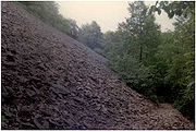
Basalt is a dark colored extrusive volcanic rock
. The weathering of iron
bearing minerals within it results in a rusty brown color when exposed to air and water, lending it a distinct reddish or purple–red hue. Basalt frequently breaks into octagonal and pentagonal columns, creating a unique "postpile" appearance. Extensive slopes made of fractured basalt talus
are visible at the base of many of the cliffs along the Metacomet Ridge.
The basalt floods of lava that now form much of the Metacomet Ridge took place over a span of 20 million years. Erosion
and deposition
occurring between the eruptions deposited layers of sediment between the lava flows which eventually lithified into sedimentary rock
layers within the basalt. The resulting "layer cake" of basalt and sedimentary rock eventually faulted and tilted upward (see fault-block). Subsequent erosion wore away many of the weaker sedimentary layers at a faster rate than the basalt layers, leaving the abruptly tilted edges of the basalt sheets exposed, creating the distinct linear ridge and dramatic cliff faces visible today. It is possible to envision this by imagining a layer cake tilted slightly up with some of the frosting (the sedimentary layer) removed in between. Evidence of this layer-cake structure is visible on Mount Norwottuck
of the Holyoke Range
in Massachusetts. The summit of Norwottuck is made of basalt; directly beneath the summit are the Horse Caves, a deep overhang where the weaker sedimentary layer has worn away at a more rapid rate than the basalt layer above it. Mount Sugarloaf
, Pocumtuck Ridge, and Mount Toby
, also in Massachusetts, together present a larger "layer cake" example. The bottom layer is composed of arkose sandstone
, visible on Mount Sugarloaf. The middle layer is composed of volcanic traprock
, most visible on the Pocumtuck Ridge. The top layer is composed of a sedimentary conglomerate
known as Mount Toby Conglomerate. Faulting and earthquake
s during the period of continental rifting tilted the layers diagonally; subsequent erosion and glacial activity exposed the tilted layers of sandstone, basalt, and conglomerate visible today as three distinct mountain masses. Although Mount Toby and Mount Sugarloaf are not composed of traprock, they are part of the Metacomet Ridge by virtue of their origin via the same rifting and uplift processes.
Of all the summits that make up the Metacomet Ridge, West Rock, in New Haven, Connecticut
, bears special mention because it was not formed by the volcanic flooding that created most of the traprock ridges. Rather, it is the remains of an enormous volcanic dike
through which the basalt lava floods found access to the surface.
While the traprock cliffs remain the most obvious evidence of the prehistoric geologic processes of the Metacomet Ridge, the sedimentary rock of the ridge and surrounding terrain has produced equally significant evidence of prehistoric life in the form of Triassic and Jurassic fossil
s, in particular, dinosaur
tracks. At one site in Rocky Hill, Connecticut
, more than 2,000 well preserved late Jurassic prints have been excavated. Other sites in Holyoke and Greenfield have likewise produced significant finds.
 The Metacomet Ridge hosts a combination of microclimate
s unusual to the region. Dry, hot upper ridges support oak savanna
s, often dominated by chestnut oak
and a variety of understory grasses and ferns. Eastern red-cedar
, a dry-loving species, clings to the barren edges of cliffs. Backslope plant communities tend to be similar to the adjacent upland plateaus and nearby Appalachians
, containing species common to the northern hardwood
and oak-hickory forest
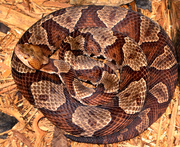
ecosystem types. Eastern hemlock crowds narrow ravines, blocking sunlight and creating damp, cooler growing conditions with associated cooler climate plant species. Talus slopes are especially rich in nutrients and support a number of calcium-loving plants uncommon in the region. Miles of high cliffs make ideal raptor
habitat, and the Metacomet Ridge is a seasonal raptor migration corridor..jpg) Because the topography of the ridge offers such varied terrain, many species reach the northern or southern limit of their range on the Metacomet Ridge; others are considered rare nationally or globally. Examples of rare species that live on the ridge include the prickly pear cactus
Because the topography of the ridge offers such varied terrain, many species reach the northern or southern limit of their range on the Metacomet Ridge; others are considered rare nationally or globally. Examples of rare species that live on the ridge include the prickly pear cactus
, peregrine falcon
, northern copperhead
, showy lady's slipper
, yellow corydalis
, ram’s–head lady's slipper
, basil mountain mint, and devil's bit lily
.
The Metacomet Ridge is also an important aquifer
. It provides municipalities and towns with public drinking water; reservoirs are located on Talcott Mountain
, Totoket Mountain
, Saltonstall Mountain
, Bradley Mountain
, Ragged Mountain, and the Hanging Hills in Connecticut. Reservoirs that supply metropolitan Springfield, Massachusetts
, are located on Provin Mountain and East Mountain.
 Native Americans occupied the river valleys surrounding the Metacomet Ridge for at least 10,000 years. Major tribal groups active in the area included the Quinnipiac
, Niantic
, Pequot
, Pocomtuc
, and Mohegan
. Traprock was used to make tools and arrowheads. Natives hunted game, gathered plants and fruits, and fished in local bodies of water around the Metacomet Ridge. Tracts of woodland in the river bottoms surrounding the ridges were sometimes burned to facilitate the cultivation of crops such as corn
, squash, tobacco
, and bean
s.
Natives incorporated the natural features of the ridgeline and surrounding geography into their spiritual belief systems. Many Native American stories were in turn incorporated into regional colonial folklore. The giant stone spirit Hobbomock (or Hobomock), a prominent figure in many stories, was credited with diverting the course of the Connecticut River
where it suddenly swings east in Middletown, Connecticut
, after several hundred miles of running due south. Hobbomuck is also credited with slaying a giant human-eating beaver
who lived in a great lake that existed in the Connecticut River Valley of Massachusetts. According to native beliefs as retold by European settlers, the corpse of the beaver remains visible as the Pocumtuck Ridge portion of the Metacomet Ridge. Later, after Hobbomuck diverted the course of the Connecticut River, he was punished to sleep forever as the prominent man-like form of the Sleeping Giant
, part of the Metacomet Ridge in southern Connecticut. There seems to be an element of scientific truth in some of these tales. For instance, the great lake that the giant beaver was said to have inhabited may very well have been the post-glacial Lake Hitchcock
, extant 10,000 years ago; the giant beaver may have been an actual prehistoric species of bear–sized beaver, Castoroides ohioensis
, that lived at that time. Many features of the Metacomet Ridge region still bear names with Native American origins: Besek, Pistapaug, Coginchaug, Mattabesett, Metacomet, Totoket, Norwottuck, Hockanum, Nonotuck, Pocumtuck, and others.
 Europeans
began settling the river valleys around the Metacomet Ridge in the mid–17th century. Forests were cut down or burned to make room for agriculture, resulting in the near complete denuding of the once contiguous forests of southern New England by the 19th century. Steep terrain like the Metacomet Ridge, while not suitable for planting crops, was widely harvested of timber as a result of the expanding charcoal
industry that boomed before the mining of coal
from the mid–Appalachian regions replaced it as a source of fuel. In other cases, ridgetop forests burned when lower elevation land was set afire, and some uplands were used for pasturing. Traprock was harvested from talus
slopes of the Metacomet Ridge to build house foundations; copper ore was discovered at the base of Peak Mountain
in northern Connecticut and was mined by prisoners incarcerated at Old Newgate Prison
located there.
With the advent of industrialization in the 19th century, riverways beneath the Metacomet Ridge were dammed to provide power as the labor force expanded in nearby cities and towns. Logging to provide additional fuel for mills further denuded the ridges. Traprock and sandstone were quarried from the ridge for paving stones and architectural brownstone
, either used locally or shipped via rail, barge, and boat.
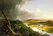
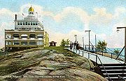 Increased urbanization and industrialization in Europe and North America resulted in an opposing aesthetic transcendentalist
movement characterized in New England by the art of Thomas Cole
, Frederic Edwin Church
, and other Hudson River School
painters, the work of landscape architects such as Frederick Law Olmsted
, and the writings of philosophers such as Henry David Thoreau
and Ralph Waldo Emerson
. As was true of other scenic areas of New England, the philosophical, artistic, and environmental movement of transcendentalism transformed the Metacomet Ridge from a commercial resource to a recreational resource. Hotels, parks, and summer estates were built on the mountains from the mid-1880s to the early 20th century. Notable structures included summit hotels and inns on Mount Holyoke
, Mount Tom
, Sugarloaf Mountain
, and Mount Nonotuck
. Parks and park structures such as Poet's Seat in Greenfield, Massachusetts
, and Hubbard Park (designed with the help of Frederick Law Olmsted) of the Hanging Hills
of Meriden, Connecticut, were intended as respites from the urban areas they closely abutted. Estates such as Hill-Stead and Heublein Tower
were built as mountain home retreats by local industrialists and commercial investors. Although public attention gradually shifted to more remote and less developed destinations with the advent of modern transportation and the westward expansion of the United States, the physical, cultural, and historic legacy of that early recreational interest in the Metacomet Ridge still supports modern conservation efforts. Estates became museums; old hotels and the lands they occupied, frequently subject to damaging fires, became state and municipal parkland through philanthropic donation, purchase, or confiscation for unpaid taxes. Nostalgia among former guests of hotels and estates contributed to the aesthetic of conservation.
, the Green Mountain Club
, the Appalachian Trail Conference
, and the Connecticut Forest and Park Association
. Following the pioneering effort of the Green Mountain Club in the inauguration of Vermont's Long Trail
in 1918, the Connecticut Forest and Park Association, spearheaded by Edgar Laing Heermance, created the 23 miles (37 km) Quinnipiac Trail
on the Metacomet Ridge in southern Connecticut in 1928 and soon followed it up with the 51 miles (82.1 km) Metacomet Trail
along the Metacomet Ridge in central and northern Connecticut. More than 700 miles (1,126.5 km) of "blue blaze trails" in Connecticut were completed by the association by the end of the 20th century. While the focus of the Appalachian Mountain Club was geared primarily toward the White Mountains
of New Hampshire in its early years, as club membership broadened, so did interest in the areas closer to club members' homes. In the late 1950s, the 110 miles (177 km) Metacomet-Monadnock Trail
was laid out by the Berkshire Chapter of the Appalachian Mountain Club under leadership of Professor Walter M. Banfield of the University of Massachusetts, Amherst. The trail follows the Metacomet Ridge for the first one–third of its length. Overall, trailbuilding had a pro-active effect on conservation awareness by thrusting portions of the Metacomet Ridge into the public consciousness.
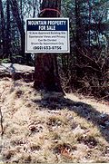 Although the Metacomet Ridge has abutted significant urban areas for nearly two hundred years, because of its rugged, steep, and rocky terrain, the ridge was long considered an undesirable place to build a home except for those wealthy enough to afford such a luxury. However, suburbanization
through urban exodus and automobile culture
, and modern construction techniques and equipment have created a demand for homes on and around the once undeveloped Metacomet Ridge and its surrounding exurban communities. As of 2007, the metropolitan areas bordering the range—New Haven
, Meriden
, New Britain
, Hartford
, Springfield
and Greenfield
—had a combined population of more than 2.5 million people. Populations in exurban towns around the range in Connecticut have increased 7.6 percent between the mid-1990s to 2000, and building permits increased 26 percent in the same period. Considered an attractive place to build homes because of its views and proximity to urban centers and highways, the Metacomet Ridge has become a target for both developers and advocates of land conservation
. Quarrying, supported by the increased need for stone in local and regional construction projects, has been especially damaging to the ecosystem, public access, and visual landscape of the ridge. At the same time, the boom in interest in outdoor recreation in the latter 20th century has made the Metacomet Ridge an attractive "active leisure" resource. In response to public interest in the ridge and its surrounding landscapes, more than twenty local non-profit organizations have become involved in conservation efforts on and around the ridge and surrounding region. Most of these organizations came into being between 1970 and 2000, and nearly all of them have evidenced a marked increase in conservation activity since 1990. Several international and national organizations have also become interested in the Metacomet Ridge, including The Nature Conservancy
, the Sierra Club
, and the Trust for Public Land.
 Steepness, long cliff–top views, and proximity to urban areas make the Metacomet Ridge a significant regional outdoor recreation resource. The ridge is traversed by more than 200 miles (321.9 km) of long-distance and shorter hiking
trails. Noteworthy trails in Connecticut include the 51 miles (82 km) Metacomet Trail
, the 50 miles (80 km) Mattabesett Trail
, the 23 miles (37 km) Quinnipiac Trail
, and the 6 miles (10 km) Regicides Trail
. Massachusetts trails include the 110 miles (177 km) Metacomet-Monadnock Trail
, the 47 miles (76 km) Robert Frost Trail
, and the 15 miles (24 km) Pocumtuck Ridge Trail
. Site–specific activities enjoyed on the ridge include rock climbing
, bouldering
, fishing
, boating
, hunting
, swimming, backcountry skiing
, cross-country skiing
, trail running
, bicycling
, and mountain biking
. Trails on the ridge are open to snowshoe
ing, birdwatching
and picnic
king as well. The Metacomet Ridge hosts more than a dozen state parks, reservations, and municipal parks, and more than three dozen nature preserves and conservation properties. Seasonal automobile roads with scenic vistas are located at Poet's Seat Park
, Mount Sugarloaf State Reservation
, J.A. Skinner State Park, the Mount Tom State Reservation
, Hubbard Park, and West Rock Ridge State Park
; these roads are also used for bicycling and cross–country skiing. Camping
and campfire
s are discouraged on most of the Metacomet Ridge, especially in Connecticut. Museums, historic sites, interpretive centers, and other attractions can be found on or near the Metacomet Ridge; some offer outdoor concerts, celebrations, and festivals.
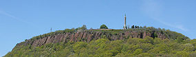
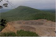 Because of its narrowness, proximity to urban areas, and fragile ecosystems, the Metacomet Ridge is most endangered by encroaching suburban sprawl. Quarry
operations, also a threat, have obliterated several square miles of traprock ridgeline in both Massachusetts and Connecticut. Ridges and mountains affected include Trimountain
, Bradley Mountain
, Totoket Mountain
, Chauncey Peak
, Rattlesnake Mountain
, East Mountain
, Pocumtuck Ridge, and the former Round Mountain
of the Holyoke Range
. The gigantic man-like profile of the Sleeping Giant
, a traprock massif visible for more than 30 miles (48.3 km) in south central Connecticut, bears quarrying scars on its "head". Mining there was halted by the efforts of local citizens and the Sleeping Giant Park Association.
Development and quarrying threats to the Metacomet Ridge have resulted in public open space acquisition efforts through collective purchasing and fundraising, active solicitation of land donations, securing of conservation easement
s, protective and restrictive legislation agreements limiting development, and, in a few cases, land taking by eminent domain
. Recent conservation milestones include the acquisition of a defunct ski area on Mount Tom
, the purchase of the ledges and summits of Ragged Mountain through the efforts of a local rock climbing club and the Nature Conservancy, and the inclusion of the ridgeline from North Branford, Connecticut
, to Belchertown, Massachusetts
, in a study by the National Park Service
for a new National Scenic Trail
now tentatively called the New England National Scenic Trail
.
New England
New England is a region in the northeastern corner of the United States consisting of the six states of Maine, New Hampshire, Vermont, Massachusetts, Rhode Island, and Connecticut...
, United States
United States
The United States of America is a federal constitutional republic comprising fifty states and a federal district...
, is a narrow and steep fault-block mountain ridge known for its extensive cliff faces, scenic vistas, microclimate
Microclimate
A microclimate is a local atmospheric zone where the climate differs from the surrounding area. The term may refer to areas as small as a few square feet or as large as many square miles...
ecosystems, and communities of plants considered rare or endangered. An important recreation resource located within 10 miles (16.1 km) of a population corridor of over 1.5 million people, the ridge is home to four long-distance hiking
Hiking
Hiking is an outdoor activity which consists of walking in natural environments, often in mountainous or other scenic terrain. People often hike on hiking trails. It is such a popular activity that there are numerous hiking organizations worldwide. The health benefits of different types of hiking...
trails and over a dozen parks and recreation areas including several state and nationally recognized historic sites. Because of its natural, historic, and recreational value, the ridge has been the focus of ongoing conservation efforts involving municipal, state, and national agencies and nearly two dozen non-profit organization
Non-profit organization
Nonprofit organization is neither a legal nor technical definition but generally refers to an organization that uses surplus revenues to achieve its goals, rather than distributing them as profit or dividends...
s.
The Metacomet Ridge extends from New Haven
New Haven, Connecticut
New Haven is the second-largest city in Connecticut and the sixth-largest in New England. According to the 2010 Census, New Haven's population increased by 5.0% between 2000 and 2010, a rate higher than that of the State of Connecticut, and higher than that of the state's five largest cities, and...
and Branford, Connecticut
Branford, Connecticut
-Landmarks and attractions:Branford has six historic districts that are listed on the U.S. National Register of Historic Places . These include buildings in Federal, Arts and Crafts, and Queen Anne styles of architecture...
, on Long Island Sound
Long Island Sound
Long Island Sound is an estuary of the Atlantic Ocean, located in the United States between Connecticut to the north and Long Island, New York to the south. The mouth of the Connecticut River at Old Saybrook, Connecticut, empties into the sound. On its western end the sound is bounded by the Bronx...
, through the Connecticut River Valley region of Massachusetts
Massachusetts
The Commonwealth of Massachusetts is a state in the New England region of the northeastern United States of America. It is bordered by Rhode Island and Connecticut to the south, New York to the west, and Vermont and New Hampshire to the north; at its east lies the Atlantic Ocean. As of the 2010...
, to northern Franklin County
Franklin County, Massachusetts
-Demographics:As of the census of 2000, there were 71,535 people, 29,466 households, and 18,416 families residing in the county. The population density was 102 people per square mile . There were 31,939 housing units at an average density of 46 per square mile...
, 2 miles (3 km) short of the Vermont
Vermont
Vermont is a state in the New England region of the northeastern United States of America. The state ranks 43rd in land area, , and 45th in total area. Its population according to the 2010 census, 630,337, is the second smallest in the country, larger only than Wyoming. It is the only New England...
and New Hampshire
New Hampshire
New Hampshire is a state in the New England region of the northeastern United States of America. The state was named after the southern English county of Hampshire. It is bordered by Massachusetts to the south, Vermont to the west, Maine and the Atlantic Ocean to the east, and the Canadian...
borders, a distance of 100 miles (160.9 km). Younger and geologically distinct from the nearby Appalachian Mountains
Appalachian Mountains
The Appalachian Mountains #Whether the stressed vowel is or ,#Whether the "ch" is pronounced as a fricative or an affricate , and#Whether the final vowel is the monophthong or the diphthong .), often called the Appalachians, are a system of mountains in eastern North America. The Appalachians...
and surrounding uplands, the Metacomet Ridge is composed of volcanic basalt
Basalt
Basalt is a common extrusive volcanic rock. It is usually grey to black and fine-grained due to rapid cooling of lava at the surface of a planet. It may be porphyritic containing larger crystals in a fine matrix, or vesicular, or frothy scoria. Unweathered basalt is black or grey...
, also known as trap rock
Trap rock
Trap rock is a form of igneous rock that tends to form polygonal vertical fractures, most typically hexagonal, but also four to eight sided. The fracture pattern forms when magma of suitable chemical composition intrudes as a sill or extrudes as a thick lava flow, and slowly cools.Because of the...
, and sedimentary rock
Sedimentary rock
Sedimentary rock are types of rock that are formed by the deposition of material at the Earth's surface and within bodies of water. Sedimentation is the collective name for processes that cause mineral and/or organic particles to settle and accumulate or minerals to precipitate from a solution....
in faulted and tilted layers many hundreds of feet thick. In most but not all cases, the basalt layers are dominant, prevalent, and exposed. Although only 1200 feet (365.8 m) above sea level at its highest, with an average summit elevation of 725 feet (221 m), the Metacomet Ridge rises dramatically from much lower valley elevations, making it a prominent landscape feature.
Geographic definitions
Holyoke Range
The Holyoke Range or Mount Holyoke Range is a traprock mountain range located in the Connecticut River Valley of Massachusetts. It is a sub-range of the narrow, linear Metacomet Ridge that extends from Long Island Sound near New Haven, Connecticut north through the Connecticut River Valley of...
in Belchertown, Massachusetts
Belchertown, Massachusetts
As of the census of 2000, there were 12,968 people, 4,886 households, and 3,517 families residing in the town. The population density was 245.9 people per square mile . There were 5,050 housing units at an average density of 95.8 per square mile...
, and ending at the Hanging Hills
Hanging Hills
The Hanging Hills of south central Connecticut, USA are a range of mountainous trap rock ridges overlooking the city of Meriden and the Quinnipiac River Valley below. They are a sub-range of the narrow, linear Metacomet Ridge that extends from Long Island Sound near New Haven, Connecticut, north...
in Meriden, Connecticut
Meriden, Connecticut
Meriden is a city in New Haven County, Connecticut, United States. According to 2005 Census Bureau estimates, the population of the city is 59,653.-History:...
. A 2004 report conducted for the National Park Service
National Park Service
The National Park Service is the U.S. federal agency that manages all national parks, many national monuments, and other conservation and historical properties with various title designations...
extends that definition to include the entire traprock ridgeline from Greenfield, Massachusetts
Greenfield, Massachusetts
Greenfield is a city in Franklin County, Massachusetts, United States. The population was 17,456 at the 2010 census. It is the county seat of Franklin County. Greenfield is home to Greenfield Community College, the Pioneer Valley Symphony Orchestra, and the Franklin County Fair...
, to Long Island Sound. The Sierra Club
Sierra Club
The Sierra Club is the oldest, largest, and most influential grassroots environmental organization in the United States. It was founded on May 28, 1892, in San Francisco, California, by the conservationist and preservationist John Muir, who became its first president...
has referred to the entire range in Connecticut as "The Traprock Ridge". Geologically and visually, the traprock ridgeline exists as one continuous landscape feature from Belchertown, Massachusetts, to Branford, Connecticut
Branford, Connecticut
-Landmarks and attractions:Branford has six historic districts that are listed on the U.S. National Register of Historic Places . These include buildings in Federal, Arts and Crafts, and Queen Anne styles of architecture...
at Long Island Sound, a distance of 71 miles (114.3 km), broken only by the river gorges of the Farmington River
Farmington River
The Farmington River is a river located in northwest Connecticut, with major tributaries extending into southwest Massachusetts. Via its longest branch , the Farmington's length increases to , making it the Connecticut River's longest tributary by a mere over the major river directly to its...
in northern Connecticut and the Westfield
Westfield River
The Westfield River in Metropolitan Springfield, Massachusetts, is a major tributary of the Connecticut River in Hampden County, Massachusetts. The Westfield River has four major tributary branches that confluence in the City of Westfield, for which the river is named...
and Connecticut River
Connecticut River
The Connecticut River is the largest and longest river in New England, and also an American Heritage River. It flows roughly south, starting from the Fourth Connecticut Lake in New Hampshire. After flowing through the remaining Connecticut Lakes and Lake Francis, it defines the border between the...
s in Massachusetts. Until January 2008, the United States Board on Geographic Names
United States Board on Geographic Names
The United States Board on Geographic Names is a United States federal body whose purpose is to establish and maintain uniform usage of geographic names throughout the U.S. government.-Overview:...
(USBGN) did not recognize Metacomet Ridge, Traprock Ridge or any other name, although several sub-ranges were identified. Geologists usually refer to the overall range generically as "the traprock ridge" or "the traprock mountains" or refer to it with regard to its prehistoric geologic significance in technical terms. Further complicating the matter is the fact that traprock only accounts for the highest surface layers of rock strata on the southern three–fourths of the range; an underlying geology of related sedimentary rock is also a part of the structure of the ridge; in north central Massachusetts it becomes the dominant strata and extends the range geologically from the Holyoke Range another 35 miles (56.3 km) through Greenfield to nearly the Vermont
Vermont
Vermont is a state in the New England region of the northeastern United States of America. The state ranks 43rd in land area, , and 45th in total area. Its population according to the 2010 census, 630,337, is the second smallest in the country, larger only than Wyoming. It is the only New England...
border. This article describes the entire Metacomet Ridge and all geologic extensions of it.
Easier to explain is the name "Metacomet
Metacomet
Metacomet , also known as King Philip or Metacom, or occasionally Pometacom, was a war chief or sachem of the Wampanoag Indians and their leader in King Philip's War, a widespread Native American uprising against English colonists in New England.-Biography:Metacomet was the second son of Massasoit...
" or "Metacom," borrowed from the 17th century sachem
Sachem
A sachem[p] or sagamore is a paramount chief among the Algonquians or other northeast American tribes. The two words are anglicizations of cognate terms from different Eastern Algonquian languages...
of the Wampanoag Tribe of southern New England who led his people during King Philip's War
King Philip's War
King Philip's War, sometimes called Metacom's War, Metacomet's War, or Metacom's Rebellion, was an armed conflict between Native American inhabitants of present-day southern New England and English colonists and their Native American allies in 1675–76. The war is named after the main leader of the...
in the mid–17th century. Metacomet was also known as King Philip by early New England colonists. A number of features associated with the Metacomet Ridge are named after the sachem, including the Metacomet Trail
Metacomet Trail
The Metacomet Trail is a Blue-Blazed hiking trail that traverses the Metacomet Ridge of central Connecticut and is a part of the newly designated New England National Scenic Trail. Despite being easily accessible and close to large population centers, the trail is considered remarkably rugged and...
, the Metacomet-Monadnock Trail
Metacomet-Monadnock Trail
The Metacomet-Monadnock Trail is a hiking trail that traverses the Metacomet Ridge of the Pioneer Valley region of Massachusetts and the central uplands of Massachusetts and southern New Hampshire...
, King Philip's Cave, King Philip Mountain, and Sachem Head. According to legend, Metacomet orchestrated the burning of Simsbury, Connecticut
Simsbury, Connecticut
Simsbury is a suburban town in Hartford County, Connecticut, United States. The population was 23,234 at the 2000 census. The town was incorporated as Connecticut's twenty-first town in May 1670.-Early history:...
, and watched the conflagration from Talcott Mountain
Talcott Mountain
Talcott Montain of central Connecticut, with a high point of , is a long trap rock mountain ridge located west of the city of Hartford. The ridge, a prominent landscape feature, forms a continuous line of exposed western cliffs visible across the Farmington River valley from Farmington to Simsbury...
near the cave now named after him. The names Metacomet and King Philip have been applied to at least sixteen landscape features and over seventy-five businesses, schools, and civic organizations throughout southern New England.
Geography
Beginning at Long Island SoundLong Island Sound
Long Island Sound is an estuary of the Atlantic Ocean, located in the United States between Connecticut to the north and Long Island, New York to the south. The mouth of the Connecticut River at Old Saybrook, Connecticut, empties into the sound. On its western end the sound is bounded by the Bronx...
, the Metacomet Ridge commences as two parallel ridges with related sub-ridges and outcrops in between; the latter include the high butte
Butte
A butte is a conspicuous isolated hill with steep, often vertical sides and a small, relatively flat top; it is smaller than mesas, plateaus, and table landform tables. In some regions, such as the north central and northwestern United States, the word is used for any hill...
–like cliffs of East Rock
East Rock
East Rock of south-central Connecticut, United States, with a high point of , is a long trap rock ridge located on the north side of the city of New Haven...
and the isolated peak of Peter's Rock
Peter's Rock
Peter's Rock, also known as Rabbit Rock, Rabbit Hill, Indian Rock and Great Rock, with a high point of above sea level, is a trap rock peak located northeast of downtown New Haven, Connecticut in the town of North Haven...
. The western ridgeline of the Metacomet Ridge begins in New Haven, Connecticut
New Haven, Connecticut
New Haven is the second-largest city in Connecticut and the sixth-largest in New England. According to the 2010 Census, New Haven's population increased by 5.0% between 2000 and 2010, a rate higher than that of the State of Connecticut, and higher than that of the state's five largest cities, and...
, as West Rock Ridge
West Rock Ridge
West Rock Ridge or West Rock of south-central Connecticut, with a high point of , is a long trap rock mountain ridge located on the west side of New Haven. The ridge forms a continuous line of exposed cliffs visible from metropolitan New Haven and points west...
and continues as Sleeping Giant
Sleeping Giant (Connecticut)
Sleeping Giant of south-central Connecticut, with a high point of , is a rugged traprock mountain located north of New Haven. It is part of the narrow, linear Metacomet Ridge that extends from Long Island Sound near New Haven, north through the Connecticut River Valley of Massachusetts to the...
, Mount Sanford
Mount Sanford (Connecticut)
Mount Sanford of south-central Connecticut, est. , is the high point on a long traprock mountain ridge located northwest of the city of New Haven. Mount Sanford is part of the narrow, linear Metacomet Ridge that extends from Long Island Sound near New Haven, north through the Connecticut River...
, Peck Mountain, and Prospect Ridge, for a distance of 16 miles (25.7 km) before diminishing into a series of low profile outcrops just short of Southington, Connecticut
Southington, Connecticut
Southington is a town in Hartford County, Connecticut, United States. It is part of Connecticut's 1st congressional district. It is situated about 20 miles southwest of Hartford, about 80 miles northeast of New York City, 105 miles southwest of Boston and 77 miles west of Providence...
, 2.75 miles (4.4 km) west of the Hanging Hills
Hanging Hills
The Hanging Hills of south central Connecticut, USA are a range of mountainous trap rock ridges overlooking the city of Meriden and the Quinnipiac River Valley below. They are a sub-range of the narrow, linear Metacomet Ridge that extends from Long Island Sound near New Haven, Connecticut, north...
in Meriden.
To the east, beginning on the rocky prominence of Beacon Hill
Beacon Hill (Branford, Connecticut)
Beacon Hill, above sea level, is a traprock outcrop located southeast of New Haven, Connecticut overlooking the mouth of the East Haven River 1.2 miles north of Long Island Sound...
, 130 feet (39.6 m), in Branford, Connecticut
Branford, Connecticut
-Landmarks and attractions:Branford has six historic districts that are listed on the U.S. National Register of Historic Places . These include buildings in Federal, Arts and Crafts, and Queen Anne styles of architecture...
, overlooking the East Haven River estuary, the Metacomet Ridge continues as a traprock ridge 60 miles (96.6 km) north to Mount Tom
Mount Tom (Massachusetts)
Mount Tom, , is a steep, rugged traprock mountain peak on the west bank of the Connecticut River 4.5 miles northwest of downtown Holyoke, Massachusetts. The mountain is the southernmost and highest peak of the Mount Tom Range and the highest traprock peak of the long Metacomet Ridge...
in Holyoke, Massachusetts
Holyoke, Massachusetts
Holyoke is a city in Hampden County, Massachusetts, United States, between the western bank of the Connecticut River and the Mount Tom Range of mountains. As of the 2010 Census, the city had a population of 39,880...
; it then breaks east across the Connecticut River
Connecticut River
The Connecticut River is the largest and longest river in New England, and also an American Heritage River. It flows roughly south, starting from the Fourth Connecticut Lake in New Hampshire. After flowing through the remaining Connecticut Lakes and Lake Francis, it defines the border between the...
to form the Holyoke Range
Holyoke Range
The Holyoke Range or Mount Holyoke Range is a traprock mountain range located in the Connecticut River Valley of Massachusetts. It is a sub-range of the narrow, linear Metacomet Ridge that extends from Long Island Sound near New Haven, Connecticut north through the Connecticut River Valley of...
, which continues for 10 miles (16.1 km) before terminating in Belchertown, Massachusetts
Belchertown, Massachusetts
As of the census of 2000, there were 12,968 people, 4,886 households, and 3,517 families residing in the town. The population density was 245.9 people per square mile . There were 5,050 housing units at an average density of 95.8 per square mile...
. Several scattered parallel ridges flank it; the most prominent of these are the hills of Rocky Hill, Connecticut
Rocky Hill, Connecticut
Rocky Hill is a town in Hartford County, Connecticut, United States. The population was 17,966 at the 2000 census. Rocky Hill was part of Wethersfield, the neighboring town to the north, until it was independently incorporated in 1849....
, and the Barn Door Hills
Barn Door Hills
The Barn Door Hills of north-central Connecticut are a pair of prominent rocky trap rock knobs separated by a steep sided gap. They are located in Granby, Connecticut. The hills are an outlying section of the narrow, linear Metacomet Ridge that extends from Long Island Sound near New Haven, north...
of Granby, Connecticut
Granby, Connecticut
Granby is a town in Hartford County, Connecticut, United States. The population was 10,347 at the 2000 census. The town center was defined as a census-designated place known as Salmon Brook in the 2000 census....
.
North of Mount Tom and the Holyoke Range, the apparent crest of the Metacomet Ridge is broken by a discontinuity in the once dominant traprock strata. Underlying sedimentary layers remain but lack the same profile. Between the Holyoke Range and the Pocumtuck Ridge, a stretch of 9 miles (14.5 km), the Metacomet Ridge exists only as a series of mostly nondescript rises set among flat plains of sedimentary bedrock. Mount Warner, 512 feet (156.1 m), in Hadley, Massachusetts
Hadley, Massachusetts
Hadley is a town in Hampshire County, Massachusetts. The population was 4,793 at the 2000 census. It is part of the Springfield, Massachusetts Metropolitan Statistical Area. The area around Hampshire Mall and Mountain Farms Mall along Route 9 is a major shopping destination for the surrounding...
, the only significant peak in the area, is a geologically unrelated metamorphic rock
Metamorphic rock
Metamorphic rock is the transformation of an existing rock type, the protolith, in a process called metamorphism, which means "change in form". The protolith is subjected to heat and pressure causing profound physical and/or chemical change...
landform that extends west into the sedimentary strata.
Sugarloaf Mountain (Franklin County, Massachusetts)
Sugarloaf Mountain or Mount Sugarloaf, is a butte-like mountain located in Deerfield, Massachusetts, United States, with two summits, North Sugarloaf Mountain and its more popular knee, South Sugarloaf Mountain . Its cliffs, made of arkose sandstone, are a very prominent landscape feature visible...
and the parallel massif of Mount Toby
Mount Toby
Mount Toby, , is the highest summit of a sprawling collection of mostly wooded hills and knolls that rise from a distinct plateau-like upland in the towns of Sunderland and Leverett, Massachusetts, just east of the Connecticut River. This mountain mass, part of the Metacomet Ridge geology, is oval...
, 1269 feet (386.8 m), the high point of the Metacomet Ridge geography. Both Sugarloaf Mountain and Mount Toby are composed of erosion-resistant sedimentary rock. North of Mount Sugarloaf, the Pocumtuck Ridge continues as alternating sedimentary and traprock dominated strata to Greenfield, Massachusetts
Greenfield, Massachusetts
Greenfield is a city in Franklin County, Massachusetts, United States. The population was 17,456 at the 2010 census. It is the county seat of Franklin County. Greenfield is home to Greenfield Community College, the Pioneer Valley Symphony Orchestra, and the Franklin County Fair...
. From Greenfield north to 2 miles (3 km) short of the Vermont–New Hampshire–Massachusetts tri–border, the profile of the Metacomet Ridge diminishes into a series of nondescript hills and low, wooded mountain peaks composed of sedimentary rock with dwindling traprock outcrops.
In Connecticut, the high point of the Metacomet Ridge is West Peak
West Peak (New Haven County, Connecticut)
West Peak, , of the Hanging Hills, is the highest traprock peak in the state of Connecticut. The peak hangs above the city of Meriden below and is characterized by its vertical cliffs and sweeping views of southern Connecticut, Long Island Sound, and the Berkshires to the west...
of the Hanging Hills at 1024 feet (312.1 m); in Massachusetts, the highest traprock peak is Mount Tom, 1202 feet (366.4 m), although Mount Toby, made of sedimentary rock, is higher. Visually, the Metacomet Ridge is narrowest at Provin Mountain
Provin Mountain
Provin Mountain is a very narrow traprock mountain ridge located in the Connecticut River Valley of Massachusetts. It is part of the Metacomet Ridge which extends from Long Island Sound near New Haven, Connecticut, north through the Connecticut River Valley of Massachusetts to the Vermont border...
and East Mountain
East Mountain (Hampden County, Massachusetts)
East Mountain is a traprock mountain ridge located in the Connecticut River Valley of Massachusetts. It is part of the narrow, linear Metacomet Ridge that extends from Long Island Sound near New Haven, Connecticut, north through the Connecticut River Valley of Massachusetts to the Vermont border...
in Massachusetts where it is less than wide; it is widest at Totoket Mountain
Totoket Mountain
Totoket Mountain, with a high point of above sea level, is a traprock massif with several distinct summits, located northeast of New Haven, Connecticut. It is part of the Metacomet Ridge that extends from Long Island Sound near New Haven, north through the Connecticut River Valley of...
, over 4 miles (6 km). However, low parallel hills and related strata along much of the range often make the actual geologic breadth of the Metacomet Ridge wider than the more noticeable ridgeline crests, up to 10 miles (16.1 km) across in some areas. Significant river drainages of the Metacomet Ridge include the Connecticut River and tributaries (Falls River
Falls River (Connecticut River)
The Falls River is a river located in Essex, Connecticut. It begins in the Pond Meadow area of Ivoryton and runs for about through Essex. Its beginnings are visible from Comstock Field at the end of Park Road in Ivoryton. Before that it runs to a small pond behind the L.C. Doane Company near Pond...
, Deerfield River
Deerfield River
Deerfield River is a river that runs for from southern Vermont through northwestern Massachusetts to the Connecticut River. The Deerfield was historically influential in the settlement of western Franklin County, Massachusetts, and its namesake town...
, Westfield River
Westfield River
The Westfield River in Metropolitan Springfield, Massachusetts, is a major tributary of the Connecticut River in Hampden County, Massachusetts. The Westfield River has four major tributary branches that confluence in the City of Westfield, for which the river is named...
, Farmington River
Farmington River
The Farmington River is a river located in northwest Connecticut, with major tributaries extending into southwest Massachusetts. Via its longest branch , the Farmington's length increases to , making it the Connecticut River's longest tributary by a mere over the major river directly to its...
, Coginchaug River
Coginchaug River
The Coginchaug River in Connecticut, with a watershed of including forests, pastures, farmland, industrial, and commercial areas, is the predominant tributary of the Mattabesset River...
); and, in southern Connecticut, the Quinnipiac River
Quinnipiac River
The Quinnipiac River is a river in the New England region of the United States, located entirely in the state of Connecticut.It rises in west central Connecticut from Dead Wood Swamp west of the city of New Britain...
.
The Metacomet Ridge is surrounded by rural wooded, agricultural, and suburban landscapes, and is no more than 6 miles (10 km) from a number of urban hubs such as New Haven, Meriden, New Britain
New Britain, Connecticut
New Britain is a city in Hartford County, Connecticut, United States. It is located approximately 9 miles southwest of Hartford. According to 2006 Census Bureau estimates, the population of the city is 71,254....
, Hartford
Hartford, Connecticut
Hartford is the capital of the U.S. state of Connecticut. The seat of Hartford County until Connecticut disbanded county government in 1960, it is the second most populous city on New England's largest river, the Connecticut River. As of the 2010 Census, Hartford's population was 124,775, making...
, and Springfield
Springfield, Massachusetts
Springfield is the most populous city in Western New England, and the seat of Hampden County, Massachusetts, United States. Springfield sits on the eastern bank of the Connecticut River near its confluence with three rivers; the western Westfield River, the eastern Chicopee River, and the eastern...
. Small city centers abutting the ridge include Greenfield, Northampton
Northampton, Massachusetts
The city of Northampton is the county seat of Hampshire County, Massachusetts, United States. As of the 2010 census, the population of Northampton's central neighborhoods, was 28,549...
, Amherst
Amherst, Massachusetts
Amherst is a town in Hampshire County, Massachusetts, United States in the Connecticut River valley. As of the 2010 census, the population was 37,819, making it the largest community in Hampshire County . The town is home to Amherst College, Hampshire College, and the University of Massachusetts...
, Holyoke
Holyoke, Massachusetts
Holyoke is a city in Hampden County, Massachusetts, United States, between the western bank of the Connecticut River and the Mount Tom Range of mountains. As of the 2010 Census, the city had a population of 39,880...
, West Hartford
West Hartford, Connecticut
West Hartford is a town located in Hartford County, Connecticut, United States. The town was incorporated in 1854. Prior to that date, the town was a parish of Hartford....
, Farmington
Farmington, Connecticut
Farmington is a town located in Hartford County in the Farmington Valley area of central Connecticut in the United States. The population was 25,340 at the 2010 census. It is home to the world headquarters of several large corporations including Carrier Corporation, Otis Elevator Company, and Carvel...
, Wallingford
Wallingford, Connecticut
Wallingford is a town in New Haven County, Connecticut, United States. The population was 43,026 at the 2000 census.- History :Wallingford was established on October 10, 1667, when the Connecticut General Assembly authorized the "making of a village on the east river" to 38 planters and freemen...
, and Hamden
Hamden, Connecticut
Hamden is a town in New Haven County, Connecticut, United States. The town's nickname is "The Land of the Sleeping Giant." Hamden is home to Quinnipiac University. The population was 58,180 according to the Census Bureau's 2005 estimates...
.
Geology
Rift
In geology, a rift or chasm is a place where the Earth's crust and lithosphere are being pulled apart and is an example of extensional tectonics....
processes that took place 200 million years ago during the Triassic
Triassic
The Triassic is a geologic period and system that extends from about 250 to 200 Mya . As the first period of the Mesozoic Era, the Triassic follows the Permian and is followed by the Jurassic. Both the start and end of the Triassic are marked by major extinction events...
and Jurassic
Jurassic
The Jurassic is a geologic period and system that extends from about Mya to Mya, that is, from the end of the Triassic to the beginning of the Cretaceous. The Jurassic constitutes the middle period of the Mesozoic era, also known as the age of reptiles. The start of the period is marked by...
periods. The basalt
Basalt
Basalt is a common extrusive volcanic rock. It is usually grey to black and fine-grained due to rapid cooling of lava at the surface of a planet. It may be porphyritic containing larger crystals in a fine matrix, or vesicular, or frothy scoria. Unweathered basalt is black or grey...
(also called traprock) crest of the Metacomet Ridge is the product of a series of massive lava
Lava
Lava refers both to molten rock expelled by a volcano during an eruption and the resulting rock after solidification and cooling. This molten rock is formed in the interior of some planets, including Earth, and some of their satellites. When first erupted from a volcanic vent, lava is a liquid at...
flows hundreds of feet thick that welled up in faults created by the rifting apart of the North America
North America
North America is a continent wholly within the Northern Hemisphere and almost wholly within the Western Hemisphere. It is also considered a northern subcontinent of the Americas...
n continent from Eurasia
Eurasia
Eurasia is a continent or supercontinent comprising the traditional continents of Europe and Asia ; covering about 52,990,000 km2 or about 10.6% of the Earth's surface located primarily in the eastern and northern hemispheres...
and Africa
Africa
Africa is the world's second largest and second most populous continent, after Asia. At about 30.2 million km² including adjacent islands, it covers 6% of the Earth's total surface area and 20.4% of the total land area...
. Essentially, the area now occupied by the Metacomet Ridge is a prehistoric rift valley
Rift valley
A rift valley is a linear-shaped lowland between highlands or mountain ranges created by the action of a geologic rift or fault. This action is manifest as crustal extension, a spreading apart of the surface which is subsequently further deepened by the forces of erosion...
which was once a branch of (or a parallel of) the major rift to the east that become the Atlantic Ocean
Atlantic Ocean
The Atlantic Ocean is the second-largest of the world's oceanic divisions. With a total area of about , it covers approximately 20% of the Earth's surface and about 26% of its water surface area...
.
Basalt is a dark colored extrusive volcanic rock
Volcanic rock
Volcanic rock is a rock formed from magma erupted from a volcano. In other words, it is an igneous rock of volcanic origin...
. The weathering of iron
Iron
Iron is a chemical element with the symbol Fe and atomic number 26. It is a metal in the first transition series. It is the most common element forming the planet Earth as a whole, forming much of Earth's outer and inner core. It is the fourth most common element in the Earth's crust...
bearing minerals within it results in a rusty brown color when exposed to air and water, lending it a distinct reddish or purple–red hue. Basalt frequently breaks into octagonal and pentagonal columns, creating a unique "postpile" appearance. Extensive slopes made of fractured basalt talus
Scree
Scree, also called talus, is a term given to an accumulation of broken rock fragments at the base of crags, mountain cliffs, or valley shoulders. Landforms associated with these materials are sometimes called scree slopes or talus piles...
are visible at the base of many of the cliffs along the Metacomet Ridge.
The basalt floods of lava that now form much of the Metacomet Ridge took place over a span of 20 million years. Erosion
Erosion
Erosion is when materials are removed from the surface and changed into something else. It only works by hydraulic actions and transport of solids in the natural environment, and leads to the deposition of these materials elsewhere...
and deposition
Deposition (geology)
Deposition is the geological process by which material is added to a landform or land mass. Fluids such as wind and water, as well as sediment flowing via gravity, transport previously eroded sediment, which, at the loss of enough kinetic energy in the fluid, is deposited, building up layers of...
occurring between the eruptions deposited layers of sediment between the lava flows which eventually lithified into sedimentary rock
Sedimentary rock
Sedimentary rock are types of rock that are formed by the deposition of material at the Earth's surface and within bodies of water. Sedimentation is the collective name for processes that cause mineral and/or organic particles to settle and accumulate or minerals to precipitate from a solution....
layers within the basalt. The resulting "layer cake" of basalt and sedimentary rock eventually faulted and tilted upward (see fault-block). Subsequent erosion wore away many of the weaker sedimentary layers at a faster rate than the basalt layers, leaving the abruptly tilted edges of the basalt sheets exposed, creating the distinct linear ridge and dramatic cliff faces visible today. It is possible to envision this by imagining a layer cake tilted slightly up with some of the frosting (the sedimentary layer) removed in between. Evidence of this layer-cake structure is visible on Mount Norwottuck
Mount Norwottuck
Mount Norwottuck, feet above sea level, is the highest peak of the Holyoke Range of traprock mountains located in the Connecticut River Valley of Massachusetts and part of the greater Metacomet Ridge which stretches from Long Island Sound to nearly the Vermont border. The peak rises steeply from...
of the Holyoke Range
Holyoke Range
The Holyoke Range or Mount Holyoke Range is a traprock mountain range located in the Connecticut River Valley of Massachusetts. It is a sub-range of the narrow, linear Metacomet Ridge that extends from Long Island Sound near New Haven, Connecticut north through the Connecticut River Valley of...
in Massachusetts. The summit of Norwottuck is made of basalt; directly beneath the summit are the Horse Caves, a deep overhang where the weaker sedimentary layer has worn away at a more rapid rate than the basalt layer above it. Mount Sugarloaf
Sugarloaf Mountain (Franklin County, Massachusetts)
Sugarloaf Mountain or Mount Sugarloaf, is a butte-like mountain located in Deerfield, Massachusetts, United States, with two summits, North Sugarloaf Mountain and its more popular knee, South Sugarloaf Mountain . Its cliffs, made of arkose sandstone, are a very prominent landscape feature visible...
, Pocumtuck Ridge, and Mount Toby
Mount Toby
Mount Toby, , is the highest summit of a sprawling collection of mostly wooded hills and knolls that rise from a distinct plateau-like upland in the towns of Sunderland and Leverett, Massachusetts, just east of the Connecticut River. This mountain mass, part of the Metacomet Ridge geology, is oval...
, also in Massachusetts, together present a larger "layer cake" example. The bottom layer is composed of arkose sandstone
Arkose
Arkose is a detrital sedimentary rock, specifically a type of sandstone containing at least 25% feldspar. Arkosic sand is sand that is similarly rich in feldspar, and thus the potential precursor of arkose....
, visible on Mount Sugarloaf. The middle layer is composed of volcanic traprock
Basalt
Basalt is a common extrusive volcanic rock. It is usually grey to black and fine-grained due to rapid cooling of lava at the surface of a planet. It may be porphyritic containing larger crystals in a fine matrix, or vesicular, or frothy scoria. Unweathered basalt is black or grey...
, most visible on the Pocumtuck Ridge. The top layer is composed of a sedimentary conglomerate
Conglomerate (geology)
A conglomerate is a rock consisting of individual clasts within a finer-grained matrix that have become cemented together. Conglomerates are sedimentary rocks consisting of rounded fragments and are thus differentiated from breccias, which consist of angular clasts...
known as Mount Toby Conglomerate. Faulting and earthquake
Earthquake
An earthquake is the result of a sudden release of energy in the Earth's crust that creates seismic waves. The seismicity, seismism or seismic activity of an area refers to the frequency, type and size of earthquakes experienced over a period of time...
s during the period of continental rifting tilted the layers diagonally; subsequent erosion and glacial activity exposed the tilted layers of sandstone, basalt, and conglomerate visible today as three distinct mountain masses. Although Mount Toby and Mount Sugarloaf are not composed of traprock, they are part of the Metacomet Ridge by virtue of their origin via the same rifting and uplift processes.
Of all the summits that make up the Metacomet Ridge, West Rock, in New Haven, Connecticut
New Haven, Connecticut
New Haven is the second-largest city in Connecticut and the sixth-largest in New England. According to the 2010 Census, New Haven's population increased by 5.0% between 2000 and 2010, a rate higher than that of the State of Connecticut, and higher than that of the state's five largest cities, and...
, bears special mention because it was not formed by the volcanic flooding that created most of the traprock ridges. Rather, it is the remains of an enormous volcanic dike
Dike (geology)
A dike or dyke in geology is a type of sheet intrusion referring to any geologic body that cuts discordantly across* planar wall rock structures, such as bedding or foliation...
through which the basalt lava floods found access to the surface.
While the traprock cliffs remain the most obvious evidence of the prehistoric geologic processes of the Metacomet Ridge, the sedimentary rock of the ridge and surrounding terrain has produced equally significant evidence of prehistoric life in the form of Triassic and Jurassic fossil
Fossil
Fossils are the preserved remains or traces of animals , plants, and other organisms from the remote past...
s, in particular, dinosaur
Dinosaur
Dinosaurs are a diverse group of animals of the clade and superorder Dinosauria. They were the dominant terrestrial vertebrates for over 160 million years, from the late Triassic period until the end of the Cretaceous , when the Cretaceous–Paleogene extinction event led to the extinction of...
tracks. At one site in Rocky Hill, Connecticut
Rocky Hill, Connecticut
Rocky Hill is a town in Hartford County, Connecticut, United States. The population was 17,966 at the 2000 census. Rocky Hill was part of Wethersfield, the neighboring town to the north, until it was independently incorporated in 1849....
, more than 2,000 well preserved late Jurassic prints have been excavated. Other sites in Holyoke and Greenfield have likewise produced significant finds.
Ecosystem
Microclimate
A microclimate is a local atmospheric zone where the climate differs from the surrounding area. The term may refer to areas as small as a few square feet or as large as many square miles...
s unusual to the region. Dry, hot upper ridges support oak savanna
Oak savanna
An oak savanna is a type of savanna, or lightly forested grassland, where oaks are the dominant tree species. These savannas were maintained historically through wildfires set by lightning, grazing, low precipitation, poor soil, and/or fires set by Native Americans...
s, often dominated by chestnut oak
Chestnut oak
Quercus prinus , the chestnut oak, is a species of oak in the white oak group, Quercus sect. Quercus. It is native to the eastern United States, where it is one of the most important ridgetop trees from southern Maine southwest to central Mississippi, with an outlying northwestern population in...
and a variety of understory grasses and ferns. Eastern red-cedar
Juniperus virginiana
Juniperus virginiana is a species of juniper native to eastern North America, from southeastern Canada to the Gulf of Mexico, east of the Great Plains...
, a dry-loving species, clings to the barren edges of cliffs. Backslope plant communities tend to be similar to the adjacent upland plateaus and nearby Appalachians
Appalachian Mountains
The Appalachian Mountains #Whether the stressed vowel is or ,#Whether the "ch" is pronounced as a fricative or an affricate , and#Whether the final vowel is the monophthong or the diphthong .), often called the Appalachians, are a system of mountains in eastern North America. The Appalachians...
, containing species common to the northern hardwood
Northern hardwood forest
The northern hardwood forest is a general type of North American forest ecosystem found over much of southeastern and south central Canada, extending south into the United States in northern New England and New York, and west along the Great Lakes to Minnesota and western Ontario...
and oak-hickory forest
Oak-hickory forest
The oak-hickory forest is a general type of North American forest ecosystem with a range extending from southern New England and New York, west to Iowa, and south to Northern Georgia. Smaller, isolated Oak-Hickory communities can also be found as far west as North Dakota, south to Florida and...
ecosystem types. Eastern hemlock crowds narrow ravines, blocking sunlight and creating damp, cooler growing conditions with associated cooler climate plant species. Talus slopes are especially rich in nutrients and support a number of calcium-loving plants uncommon in the region. Miles of high cliffs make ideal raptor
Bird of prey
Birds of prey are birds that hunt for food primarily on the wing, using their keen senses, especially vision. They are defined as birds that primarily hunt vertebrates, including other birds. Their talons and beaks tend to be relatively large, powerful and adapted for tearing and/or piercing flesh....
habitat, and the Metacomet Ridge is a seasonal raptor migration corridor.
Opuntia
Opuntia, also known as nopales or paddle cactus , is a genus in the cactus family, Cactaceae.Currently, only prickly pears are included in this genus of about 200 species distributed throughout most of the Americas. Chollas are now separated into the genus Cylindropuntia, which some still consider...
, peregrine falcon
Peregrine Falcon
The Peregrine Falcon , also known as the Peregrine, and historically as the Duck Hawk in North America, is a widespread bird of prey in the family Falconidae. A large, crow-sized falcon, it has a blue-gray back, barred white underparts, and a black head and "moustache"...
, northern copperhead
Agkistrodon contortrix mokasen
Agkistrodon contortrix mokasen is a venomous pitviper subspecies found in the eastern United States.-Description:The Northern copperhead grows to an average length of 61-91 cm , with a maximum of 134.6 cm ....
, showy lady's slipper
Cypripedium reginae
The Showy Lady's-slipper , also known as the Pink-and-white Lady's-slipper or the Queen's Lady's-slipper, is a rare terrestrial temperate lady's-slipper orchid native to northern North America....
, yellow corydalis
Corydalis lutea
Pseudofumaria lutea is a short-lived perennial plant native to the southern foothills of the south-western and central Alps of Italy and Switzerland, but widely introduced elsewhere....
, ram’s–head lady's slipper
Cypripedium arietinum
The rare Ram's-Head Lady's-Slipper is an orchid that is native to the alvars around the Great Lakes in North America.The plant grows to 10-40 cm , and the flowers may reach 1-2 cm...
, basil mountain mint, and devil's bit lily
Chamaelirium
Chamaelirium luteum, commonly known as Blazing-Star, Devil's Bit, Fairy Wand, False Unicorn, is a perennial herb native to the eastern United States...
.
The Metacomet Ridge is also an important aquifer
Aquifer
An aquifer is a wet underground layer of water-bearing permeable rock or unconsolidated materials from which groundwater can be usefully extracted using a water well. The study of water flow in aquifers and the characterization of aquifers is called hydrogeology...
. It provides municipalities and towns with public drinking water; reservoirs are located on Talcott Mountain
Talcott Mountain
Talcott Montain of central Connecticut, with a high point of , is a long trap rock mountain ridge located west of the city of Hartford. The ridge, a prominent landscape feature, forms a continuous line of exposed western cliffs visible across the Farmington River valley from Farmington to Simsbury...
, Totoket Mountain
Totoket Mountain
Totoket Mountain, with a high point of above sea level, is a traprock massif with several distinct summits, located northeast of New Haven, Connecticut. It is part of the Metacomet Ridge that extends from Long Island Sound near New Haven, north through the Connecticut River Valley of...
, Saltonstall Mountain
Saltonstall Mountain
Saltonstall Mountain, also known as Saltonstall Ridge, with a high point of above sea level, is a traprock mountain ridge located east of New Haven, Connecticut and north of Long Island Sound. It is part of the Metacomet Ridge that extends from Long Island Sound near New Haven, Connecticut,...
, Bradley Mountain
Bradley Mountain
Bradley Mountain, , is a traprock mountain located west of New Britain, Connecticut, USA, in the town of Southington and PlainvilleIt is part of the narrow, linear Metacomet Ridge that extends from Long Island Sound near New Haven, Connecticut, north through the Connecticut River Valley of...
, Ragged Mountain, and the Hanging Hills in Connecticut. Reservoirs that supply metropolitan Springfield, Massachusetts
Springfield, Massachusetts
Springfield is the most populous city in Western New England, and the seat of Hampden County, Massachusetts, United States. Springfield sits on the eastern bank of the Connecticut River near its confluence with three rivers; the western Westfield River, the eastern Chicopee River, and the eastern...
, are located on Provin Mountain and East Mountain.
Pre-colonial era
Quinnipiac
This article is about the Native American nation. For the university, see Quinnipiac University.The Quinnipiac — rarely spelled Quinnipiack — is the English name for the Eansketambawg a Native American nation of the Algonquian family who inhabited the Wampanoki This article is about the Native...
, Niantic
Niantic (tribe)
The Niantic, or in their own language, the Nehântick or Nehantucket were a tribe of New England Native Americans, who were living in Connecticut and Rhode Island during the early colonial period. Due to intrusions of the Pequot, the Niantic were divided into an eastern and western division...
, Pequot
Pequot
Pequot people are a tribe of Native Americans who, in the 17th century, inhabited much of what is now Connecticut. They were of the Algonquian language family. The Pequot War and Mystic massacre reduced the Pequot's sociopolitical influence in southern New England...
, Pocomtuc
Pocomtuc
The Pocumtuck, also Pocomtuc or Deerfield Indians, were a Native American tribe formerly inhabiting western Massachusetts, especially around the confluence of the Deerfield and Connecticut Rivers in Franklin County. Their territory also included parts of Hampden and Hampshire County, as well as...
, and Mohegan
Mohegan
The Mohegan tribe is an Algonquian-speaking tribe that lives in the eastern upper Thames River valley of Connecticut. Mohegan translates to "People of the Wolf". At the time of European contact, the Mohegan and Pequot were one people, historically living in the lower Connecticut region...
. Traprock was used to make tools and arrowheads. Natives hunted game, gathered plants and fruits, and fished in local bodies of water around the Metacomet Ridge. Tracts of woodland in the river bottoms surrounding the ridges were sometimes burned to facilitate the cultivation of crops such as corn
Maize
Maize known in many English-speaking countries as corn or mielie/mealie, is a grain domesticated by indigenous peoples in Mesoamerica in prehistoric times. The leafy stalk produces ears which contain seeds called kernels. Though technically a grain, maize kernels are used in cooking as a vegetable...
, squash, tobacco
Tobacco
Tobacco is an agricultural product processed from the leaves of plants in the genus Nicotiana. It can be consumed, used as a pesticide and, in the form of nicotine tartrate, used in some medicines...
, and bean
Bean
Bean is a common name for large plant seeds of several genera of the family Fabaceae used for human food or animal feed....
s.
Natives incorporated the natural features of the ridgeline and surrounding geography into their spiritual belief systems. Many Native American stories were in turn incorporated into regional colonial folklore. The giant stone spirit Hobbomock (or Hobomock), a prominent figure in many stories, was credited with diverting the course of the Connecticut River
Connecticut River
The Connecticut River is the largest and longest river in New England, and also an American Heritage River. It flows roughly south, starting from the Fourth Connecticut Lake in New Hampshire. After flowing through the remaining Connecticut Lakes and Lake Francis, it defines the border between the...
where it suddenly swings east in Middletown, Connecticut
Middletown, Connecticut
Middletown is a city located in Middlesex County, Connecticut, along the Connecticut River, in the central part of the state, 16 miles south of Hartford. In 1650, it was incorporated as a town under its original Indian name, Mattabeseck. It received its present name in 1653. In 1784, the central...
, after several hundred miles of running due south. Hobbomuck is also credited with slaying a giant human-eating beaver
Beaver
The beaver is a primarily nocturnal, large, semi-aquatic rodent. Castor includes two extant species, North American Beaver and Eurasian Beaver . Beavers are known for building dams, canals, and lodges . They are the second-largest rodent in the world...
who lived in a great lake that existed in the Connecticut River Valley of Massachusetts. According to native beliefs as retold by European settlers, the corpse of the beaver remains visible as the Pocumtuck Ridge portion of the Metacomet Ridge. Later, after Hobbomuck diverted the course of the Connecticut River, he was punished to sleep forever as the prominent man-like form of the Sleeping Giant
Sleeping Giant (Connecticut)
Sleeping Giant of south-central Connecticut, with a high point of , is a rugged traprock mountain located north of New Haven. It is part of the narrow, linear Metacomet Ridge that extends from Long Island Sound near New Haven, north through the Connecticut River Valley of Massachusetts to the...
, part of the Metacomet Ridge in southern Connecticut. There seems to be an element of scientific truth in some of these tales. For instance, the great lake that the giant beaver was said to have inhabited may very well have been the post-glacial Lake Hitchcock
Lake Hitchcock
Lake Hitchcock was a glacial lake that formed approximately 15,000 years ago in the late Pleistocene epoch. After the Laurentide ice sheet retreated, glacial ice melt accumulated at the terminal moraine and blocked up the Connecticut River, creating the long, narrow lake...
, extant 10,000 years ago; the giant beaver may have been an actual prehistoric species of bear–sized beaver, Castoroides ohioensis
Giant Beaver
Castoroides ohioensis was a species of giant beaver, huge members of the family Castoridae , endemic to North America during the Pleistocene epoch .-Morphology:...
, that lived at that time. Many features of the Metacomet Ridge region still bear names with Native American origins: Besek, Pistapaug, Coginchaug, Mattabesett, Metacomet, Totoket, Norwottuck, Hockanum, Nonotuck, Pocumtuck, and others.
Colonization, agricultural transformation, and industrialization
European ethnic groups
The ethnic groups in Europe are the various ethnic groups that reside in the nations of Europe. European ethnology is the field of anthropology focusing on Europe....
began settling the river valleys around the Metacomet Ridge in the mid–17th century. Forests were cut down or burned to make room for agriculture, resulting in the near complete denuding of the once contiguous forests of southern New England by the 19th century. Steep terrain like the Metacomet Ridge, while not suitable for planting crops, was widely harvested of timber as a result of the expanding charcoal
Charcoal
Charcoal is the dark grey residue consisting of carbon, and any remaining ash, obtained by removing water and other volatile constituents from animal and vegetation substances. Charcoal is usually produced by slow pyrolysis, the heating of wood or other substances in the absence of oxygen...
industry that boomed before the mining of coal
Coal
Coal is a combustible black or brownish-black sedimentary rock usually occurring in rock strata in layers or veins called coal beds or coal seams. The harder forms, such as anthracite coal, can be regarded as metamorphic rock because of later exposure to elevated temperature and pressure...
from the mid–Appalachian regions replaced it as a source of fuel. In other cases, ridgetop forests burned when lower elevation land was set afire, and some uplands were used for pasturing. Traprock was harvested from talus
Scree
Scree, also called talus, is a term given to an accumulation of broken rock fragments at the base of crags, mountain cliffs, or valley shoulders. Landforms associated with these materials are sometimes called scree slopes or talus piles...
slopes of the Metacomet Ridge to build house foundations; copper ore was discovered at the base of Peak Mountain
Peak Mountain
Peak Mountain, also called Copper Mountain, est. , is a traprock mountain located in East Granby, Connecticut, south of the Massachusetts border and 6 miles west of the Connecticut River...
in northern Connecticut and was mined by prisoners incarcerated at Old Newgate Prison
Old Newgate Prison
Old Newgate Prison was a Colonial American prison in what is now East Granby, Connecticut. It is now a historic site.The prison was originally a copper mine, opened in 1705, and is believed to be the first copper mine in America. After mining operations proved unprofitable, the colony of...
located there.
With the advent of industrialization in the 19th century, riverways beneath the Metacomet Ridge were dammed to provide power as the labor force expanded in nearby cities and towns. Logging to provide additional fuel for mills further denuded the ridges. Traprock and sandstone were quarried from the ridge for paving stones and architectural brownstone
Brownstone
Brownstone is a brown Triassic or Jurassic sandstone which was once a popular building material. The term is also used in the United States to refer to a terraced house clad in this material.-Types:-Apostle Island brownstone:...
, either used locally or shipped via rail, barge, and boat.
Transcendentalism
Transcendentalism
Transcendentalism is a philosophical movement that developed in the 1830s and 1840s in the New England region of the United States as a protest against the general state of culture and society, and in particular, the state of intellectualism at Harvard University and the doctrine of the Unitarian...
movement characterized in New England by the art of Thomas Cole
Thomas Cole
Thomas Cole was an English-born American artist. He is regarded as the founder of the Hudson River School, an American art movement that flourished in the mid-19th century...
, Frederic Edwin Church
Frederic Edwin Church
Frederic Edwin Church was an American landscape painter born in Hartford, Connecticut. He was a central figure in the Hudson River School of American landscape painters...
, and other Hudson River School
Hudson River school
The Hudson River School was a mid-19th century American art movement embodied by a group of landscape painters whose aesthetic vision was influenced by romanticism...
painters, the work of landscape architects such as Frederick Law Olmsted
Frederick Law Olmsted
Frederick Law Olmsted was an American journalist, social critic, public administrator, and landscape designer. He is popularly considered to be the father of American landscape architecture, although many scholars have bestowed that title upon Andrew Jackson Downing...
, and the writings of philosophers such as Henry David Thoreau
Henry David Thoreau
Henry David Thoreau was an American author, poet, philosopher, abolitionist, naturalist, tax resister, development critic, surveyor, historian, and leading transcendentalist...
and Ralph Waldo Emerson
Ralph Waldo Emerson
Ralph Waldo Emerson was an American essayist, lecturer, and poet, who led the Transcendentalist movement of the mid-19th century...
. As was true of other scenic areas of New England, the philosophical, artistic, and environmental movement of transcendentalism transformed the Metacomet Ridge from a commercial resource to a recreational resource. Hotels, parks, and summer estates were built on the mountains from the mid-1880s to the early 20th century. Notable structures included summit hotels and inns on Mount Holyoke
Mount Holyoke
Mount Holyoke, a traprock mountain, elevation , is the western-most peak of the Holyoke Range and part of the 100-mile Metacomet Ridge. The mountain is located in the Connecticut River Valley of western Massachusetts, and is the namesake of nearby Mount Holyoke College. The mountain is located in...
, Mount Tom
Mount Tom (Massachusetts)
Mount Tom, , is a steep, rugged traprock mountain peak on the west bank of the Connecticut River 4.5 miles northwest of downtown Holyoke, Massachusetts. The mountain is the southernmost and highest peak of the Mount Tom Range and the highest traprock peak of the long Metacomet Ridge...
, Sugarloaf Mountain
Sugarloaf Mountain (Franklin County, Massachusetts)
Sugarloaf Mountain or Mount Sugarloaf, is a butte-like mountain located in Deerfield, Massachusetts, United States, with two summits, North Sugarloaf Mountain and its more popular knee, South Sugarloaf Mountain . Its cliffs, made of arkose sandstone, are a very prominent landscape feature visible...
, and Mount Nonotuck
Mount Nonotuck
Mount Nonotuck, , is the northernmost peak of the Mount Tom Range of traprock mountains located in the Connecticut River Valley of Massachusetts and part of the larger Metacomet Ridge which stretches from Long Island Sound to nearly the Vermont border. Rugged and considered scenic, the peak rises...
. Parks and park structures such as Poet's Seat in Greenfield, Massachusetts
Greenfield, Massachusetts
Greenfield is a city in Franklin County, Massachusetts, United States. The population was 17,456 at the 2010 census. It is the county seat of Franklin County. Greenfield is home to Greenfield Community College, the Pioneer Valley Symphony Orchestra, and the Franklin County Fair...
, and Hubbard Park (designed with the help of Frederick Law Olmsted) of the Hanging Hills
Hanging Hills
The Hanging Hills of south central Connecticut, USA are a range of mountainous trap rock ridges overlooking the city of Meriden and the Quinnipiac River Valley below. They are a sub-range of the narrow, linear Metacomet Ridge that extends from Long Island Sound near New Haven, Connecticut, north...
of Meriden, Connecticut, were intended as respites from the urban areas they closely abutted. Estates such as Hill-Stead and Heublein Tower
Heublein Tower
The Heublein Tower located in Talcott Mountain State Park in Connecticut provides panoramic views of the Hartford skyline and the Farmington River Valley that are particularly spectacular in the fall.-Origin:...
were built as mountain home retreats by local industrialists and commercial investors. Although public attention gradually shifted to more remote and less developed destinations with the advent of modern transportation and the westward expansion of the United States, the physical, cultural, and historic legacy of that early recreational interest in the Metacomet Ridge still supports modern conservation efforts. Estates became museums; old hotels and the lands they occupied, frequently subject to damaging fires, became state and municipal parkland through philanthropic donation, purchase, or confiscation for unpaid taxes. Nostalgia among former guests of hotels and estates contributed to the aesthetic of conservation.
Trailbuilding
Interest in mountains as places to build recreational footpaths took root in New England with organizations such as the Appalachian Mountain ClubAppalachian Mountain Club
The Appalachian Mountain Club is one of the United States' oldest outdoor groups. Created in 1876 to explore and preserve the White Mountains in New Hampshire, it has expanded throughout the northeastern U.S., with 12 chapters stretching from Maine to Washington, D.C...
, the Green Mountain Club
Green Mountain Club
The Green Mountain Club is a non-profit membership organization dedicated to preserving and protecting Vermont's Long Trail - America's first long-distance hiking trail which stretches from Massachusetts to the Canadian border along Vermont's high ridgeline...
, the Appalachian Trail Conference
Appalachian Trail Conservancy
The Appalachian Trail Conservancy is a nonprofit organization dedicated to the conservation of the Appalachian Trail, which runs from Maine to Georgia...
, and the Connecticut Forest and Park Association
Connecticut Forest and Park Association
The Connecticut Forest and Park Association , established in 1895, is the oldest private, nonprofit conservation organization in Connecticut. The organization is credited as an important early pioneer of the national land conservation movement and as an early advocate of long distance trail building...
. Following the pioneering effort of the Green Mountain Club in the inauguration of Vermont's Long Trail
Long Trail
The Long Trail is a hiking trail located in Vermont, running the length of the state. It is the oldest long-distance trail in the United States, constructed between 1910 and 1930 by the Green Mountain Club...
in 1918, the Connecticut Forest and Park Association, spearheaded by Edgar Laing Heermance, created the 23 miles (37 km) Quinnipiac Trail
Quinnipiac Trail
The Quinnipiac Trail is a Blue-Blazed hiking trail in New Haven County, Connecticut. It is the product of the evolution and growth of the first trail designated in Connecticut's Blue-Blazed Hiking Trail system, with its light-blue rectangular vertical painted blazes .-The route:From its...
on the Metacomet Ridge in southern Connecticut in 1928 and soon followed it up with the 51 miles (82.1 km) Metacomet Trail
Metacomet Trail
The Metacomet Trail is a Blue-Blazed hiking trail that traverses the Metacomet Ridge of central Connecticut and is a part of the newly designated New England National Scenic Trail. Despite being easily accessible and close to large population centers, the trail is considered remarkably rugged and...
along the Metacomet Ridge in central and northern Connecticut. More than 700 miles (1,126.5 km) of "blue blaze trails" in Connecticut were completed by the association by the end of the 20th century. While the focus of the Appalachian Mountain Club was geared primarily toward the White Mountains
White Mountains (New Hampshire)
The White Mountains are a mountain range covering about a quarter of the state of New Hampshire and a small portion of western Maine in the United States. Part of the Appalachian Mountains, they are considered the most rugged mountains in New England...
of New Hampshire in its early years, as club membership broadened, so did interest in the areas closer to club members' homes. In the late 1950s, the 110 miles (177 km) Metacomet-Monadnock Trail
Metacomet-Monadnock Trail
The Metacomet-Monadnock Trail is a hiking trail that traverses the Metacomet Ridge of the Pioneer Valley region of Massachusetts and the central uplands of Massachusetts and southern New Hampshire...
was laid out by the Berkshire Chapter of the Appalachian Mountain Club under leadership of Professor Walter M. Banfield of the University of Massachusetts, Amherst. The trail follows the Metacomet Ridge for the first one–third of its length. Overall, trailbuilding had a pro-active effect on conservation awareness by thrusting portions of the Metacomet Ridge into the public consciousness.
Suburbanization and land conservation
Suburbanization
Suburbanization a term used to describe the growth of areas on the fringes of major cities. It is one of the many causes of the increase in urban sprawl. Many residents of metropolitan regions work within the central urban area, choosing instead to live in satellite communities called suburbs...
through urban exodus and automobile culture
Effects of the automobile on societies
Over the course of the 20th century, the automobile rapidly developed from an expensive toy for the rich into the de facto standard for passenger transport in most developed countries. In developing countries, the effects of the automobile have lagged, but are emulating the impacts of developed...
, and modern construction techniques and equipment have created a demand for homes on and around the once undeveloped Metacomet Ridge and its surrounding exurban communities. As of 2007, the metropolitan areas bordering the range—New Haven
New Haven, Connecticut
New Haven is the second-largest city in Connecticut and the sixth-largest in New England. According to the 2010 Census, New Haven's population increased by 5.0% between 2000 and 2010, a rate higher than that of the State of Connecticut, and higher than that of the state's five largest cities, and...
, Meriden
Meriden, Connecticut
Meriden is a city in New Haven County, Connecticut, United States. According to 2005 Census Bureau estimates, the population of the city is 59,653.-History:...
, New Britain
New Britain, Connecticut
New Britain is a city in Hartford County, Connecticut, United States. It is located approximately 9 miles southwest of Hartford. According to 2006 Census Bureau estimates, the population of the city is 71,254....
, Hartford
Hartford, Connecticut
Hartford is the capital of the U.S. state of Connecticut. The seat of Hartford County until Connecticut disbanded county government in 1960, it is the second most populous city on New England's largest river, the Connecticut River. As of the 2010 Census, Hartford's population was 124,775, making...
, Springfield
Springfield, Massachusetts
Springfield is the most populous city in Western New England, and the seat of Hampden County, Massachusetts, United States. Springfield sits on the eastern bank of the Connecticut River near its confluence with three rivers; the western Westfield River, the eastern Chicopee River, and the eastern...
and Greenfield
Greenfield, Massachusetts
Greenfield is a city in Franklin County, Massachusetts, United States. The population was 17,456 at the 2010 census. It is the county seat of Franklin County. Greenfield is home to Greenfield Community College, the Pioneer Valley Symphony Orchestra, and the Franklin County Fair...
—had a combined population of more than 2.5 million people. Populations in exurban towns around the range in Connecticut have increased 7.6 percent between the mid-1990s to 2000, and building permits increased 26 percent in the same period. Considered an attractive place to build homes because of its views and proximity to urban centers and highways, the Metacomet Ridge has become a target for both developers and advocates of land conservation
Conservation movement
The conservation movement, also known as nature conservation, is a political, environmental and a social movement that seeks to protect natural resources including animal, fungus and plant species as well as their habitat for the future....
. Quarrying, supported by the increased need for stone in local and regional construction projects, has been especially damaging to the ecosystem, public access, and visual landscape of the ridge. At the same time, the boom in interest in outdoor recreation in the latter 20th century has made the Metacomet Ridge an attractive "active leisure" resource. In response to public interest in the ridge and its surrounding landscapes, more than twenty local non-profit organizations have become involved in conservation efforts on and around the ridge and surrounding region. Most of these organizations came into being between 1970 and 2000, and nearly all of them have evidenced a marked increase in conservation activity since 1990. Several international and national organizations have also become interested in the Metacomet Ridge, including The Nature Conservancy
The Nature Conservancy
The Nature Conservancy is a US charitable environmental organization that works to preserve the plants, animals, and natural communities that represent the diversity of life on Earth by protecting the lands and waters they need to survive....
, the Sierra Club
Sierra Club
The Sierra Club is the oldest, largest, and most influential grassroots environmental organization in the United States. It was founded on May 28, 1892, in San Francisco, California, by the conservationist and preservationist John Muir, who became its first president...
, and the Trust for Public Land.
Recreation
Hiking
Hiking is an outdoor activity which consists of walking in natural environments, often in mountainous or other scenic terrain. People often hike on hiking trails. It is such a popular activity that there are numerous hiking organizations worldwide. The health benefits of different types of hiking...
trails. Noteworthy trails in Connecticut include the 51 miles (82 km) Metacomet Trail
Metacomet Trail
The Metacomet Trail is a Blue-Blazed hiking trail that traverses the Metacomet Ridge of central Connecticut and is a part of the newly designated New England National Scenic Trail. Despite being easily accessible and close to large population centers, the trail is considered remarkably rugged and...
, the 50 miles (80 km) Mattabesett Trail
Mattabesett Trail
The Mattabesett Trail is a long, hook-shaped Blue-Blazed hiking trail in central Connecticut and a part of the newly designated New England National Scenic Trail. One half of the trail follows the high traprock ridges of the Metacomet Ridge, from Totoket Mountain in Guilford, Connecticut to...
, the 23 miles (37 km) Quinnipiac Trail
Quinnipiac Trail
The Quinnipiac Trail is a Blue-Blazed hiking trail in New Haven County, Connecticut. It is the product of the evolution and growth of the first trail designated in Connecticut's Blue-Blazed Hiking Trail system, with its light-blue rectangular vertical painted blazes .-The route:From its...
, and the 6 miles (10 km) Regicides Trail
Regicides Trail
Regicides Trail is a Blue-Blazed hiking trail, about 7 miles long, roughly following the edge of a basalt, or traprock, cliff northwest of New Haven, Connecticut. It is named for two regicides, Edward Whalley and his son-in-law William Goffe, who signed the death warrant of King Charles I of England...
. Massachusetts trails include the 110 miles (177 km) Metacomet-Monadnock Trail
Metacomet-Monadnock Trail
The Metacomet-Monadnock Trail is a hiking trail that traverses the Metacomet Ridge of the Pioneer Valley region of Massachusetts and the central uplands of Massachusetts and southern New Hampshire...
, the 47 miles (76 km) Robert Frost Trail
Robert Frost Trail (Massachusetts)
The Robert Frost Trail is a long footpath that passes through the eastern Connecticut River Valley of Massachusetts. The trail runs from the Connecticut River in South Hadley, Massachusetts to Ruggles Pond in Wendell State Forest, through both Hampshire and Franklin County and includes a number of...
, and the 15 miles (24 km) Pocumtuck Ridge Trail
Pocumtuck Ridge Trail
The Pocumtuck Ridge Trail is a footpath that traverses the Pocumtuck Range of Deerfield and Greenfield, Massachusetts.The trail is known for its dramatic views of the Deerfield River and Connecticut River valleys from extensive cliff faces...
. Site–specific activities enjoyed on the ridge include rock climbing
Rock climbing
Rock climbing also lightly called 'The Gravity Game', is a sport in which participants climb up, down or across natural rock formations or artificial rock walls. The goal is to reach the summit of a formation or the endpoint of a pre-defined route without falling...
, bouldering
Bouldering
Bouldering is a style of rock climbing undertaken without a rope and normally limited to very short climbs over a crash pad so that a fall will not result in serious injury. It is typically practiced on large natural boulders or artificial boulders in gyms and outdoor urban areas...
, fishing
Fishing
Fishing is the activity of trying to catch wild fish. Fish are normally caught in the wild. Techniques for catching fish include hand gathering, spearing, netting, angling and trapping....
, boating
Boating
Boating is the leisurely activity of travelling by boat, or the recreational use of a boat whether powerboats, sailboats, or man-powered vessels , focused on the travel itself, as well as sports activities, such as fishing or water skiing...
, hunting
Hunting
Hunting is the practice of pursuing any living thing, usually wildlife, for food, recreation, or trade. In present-day use, the term refers to lawful hunting, as distinguished from poaching, which is the killing, trapping or capture of the hunted species contrary to applicable law...
, swimming, backcountry skiing
Backcountry skiing
Backcountry skiing is skiing in a sparsely inhabited rural region over ungroomed and unmarked slopes or pistes, including skiing in unmarked or unpatrolled areas either within the ski resort's boundaries or in the backcountry, frequently amongst trees , usually in pursuit of fresh fallen powder...
, cross-country skiing
Cross-country skiing
Cross-country skiing is a winter sport in which participants propel themselves across snow-covered terrain using skis and poles...
, trail running
Trail running
Trail running is a variant on running that differs markedly from road running and track running. Trail running generally takes place on hiking trails, most commonly single track trails, although fire roads are not uncommon. A distinguishing characteristic of the trails is that they are often...
, bicycling
Cycling
Cycling, also called bicycling or biking, is the use of bicycles for transport, recreation, or for sport. Persons engaged in cycling are cyclists or bicyclists...
, and mountain biking
Mountain biking
Mountain biking is a sport which consists of riding bicycles off-road, often over rough terrain, using specially adapted mountain bikes. Mountain bikes share similarities with other bikes, but incorporate features designed to enhance durability and performance in rough terrain.Mountain biking can...
. Trails on the ridge are open to snowshoe
Snowshoe
A snowshoe is footwear for walking over the snow. Snowshoes work by distributing the weight of the person over a larger area so that the person's foot does not sink completely into the snow, a quality called "flotation"....
ing, birdwatching
Birdwatching
Birdwatching or birding is the observation of birds as a recreational activity. It can be done with the naked eye, through a visual enhancement device like binoculars and telescopes, or by listening for bird sounds. Birding often involves a significant auditory component, as many bird species are...
and picnic
Picnic
In contemporary usage, a picnic can be defined simply as a pleasure excursion at which a meal is eaten outdoors , ideally taking place in a beautiful landscape such as a park, beside a lake or with an interesting view and possibly at a public event such as before an open air theatre performance,...
king as well. The Metacomet Ridge hosts more than a dozen state parks, reservations, and municipal parks, and more than three dozen nature preserves and conservation properties. Seasonal automobile roads with scenic vistas are located at Poet's Seat Park
Pocumtuck Range
The Pocumtuck Range, also referred to as the Pocumtuck Ridge, is the northern-most subrange of the Metacomet Ridge mountain range of southern New England...
, Mount Sugarloaf State Reservation
Mount Sugarloaf State Reservation
Sugarloaf Mountain State Reservation, managed by the Massachusetts Department of Conservation and Recreation, is located in Deerfield, Massachusetts, just west of the Connecticut River...
, J.A. Skinner State Park, the Mount Tom State Reservation
Mount Tom State Reservation
The Mount Tom State Reservation, , encompasses the Mount Tom Range and is located in the Connecticut River Valley region of Massachusetts, just north of the city of Springfield....
, Hubbard Park, and West Rock Ridge State Park
West Rock Ridge State Park
West Rock Ridge State Park is a state park located in New Haven, Hamden, and Woodbridge, Connecticut. It is named for the trap rock West Rock Ridge, which is part of the Metacomet Ridge extending from Long Island Sound to the Vermont border. The ridge consists largely of diabase basalt, much like...
; these roads are also used for bicycling and cross–country skiing. Camping
Camping
Camping is an outdoor recreational activity. The participants leave urban areas, their home region, or civilization and enjoy nature while spending one or several nights outdoors, usually at a campsite. Camping may involve the use of a tent, caravan, motorhome, cabin, a primitive structure, or no...
and campfire
Campfire
A campfire is a fire lit at a campsite, to serve the following functions: light, warmth, a beacon, a bug and/or apex predator deterrent, to cook, and for a psychological sense of security. In established campgrounds they are usually in a fire ring for safety. Campfires are a popular feature of...
s are discouraged on most of the Metacomet Ridge, especially in Connecticut. Museums, historic sites, interpretive centers, and other attractions can be found on or near the Metacomet Ridge; some offer outdoor concerts, celebrations, and festivals.
Conservation
Quarry
A quarry is a type of open-pit mine from which rock or minerals are extracted. Quarries are generally used for extracting building materials, such as dimension stone, construction aggregate, riprap, sand, and gravel. They are often collocated with concrete and asphalt plants due to the requirement...
operations, also a threat, have obliterated several square miles of traprock ridgeline in both Massachusetts and Connecticut. Ridges and mountains affected include Trimountain
Trimountain
Trimountain or Tri-mountain, est. , is a traprock mountain located southeast of Meriden, Connecticut. It is part of the narrow, linear Metacomet Ridge that extends from Long Island Sound near New Haven, Connecticut, north through the Connecticut River Valley of Massachusetts to the Vermont border...
, Bradley Mountain
Bradley Mountain
Bradley Mountain, , is a traprock mountain located west of New Britain, Connecticut, USA, in the town of Southington and PlainvilleIt is part of the narrow, linear Metacomet Ridge that extends from Long Island Sound near New Haven, Connecticut, north through the Connecticut River Valley of...
, Totoket Mountain
Totoket Mountain
Totoket Mountain, with a high point of above sea level, is a traprock massif with several distinct summits, located northeast of New Haven, Connecticut. It is part of the Metacomet Ridge that extends from Long Island Sound near New Haven, north through the Connecticut River Valley of...
, Chauncey Peak
Chauncey Peak
Chauncey Peak, , is a traprock mountain located 2 miles northeast of the center of Meriden, Connecticut. It is part of the narrow, linear Metacomet Ridge that extends from Long Island Sound near New Haven, Connecticut, north through the Connecticut River Valley of Massachusetts to the Vermont border...
, Rattlesnake Mountain
Rattlesnake Mountain (Connecticut)
Rattlesnake Mountain is a traprock mountain, above sea level, located southwest of Hartford, Connecticut in the town of Farmington. It is part of the narrow, linear Metacomet Ridge that extends from Long Island Sound near New Haven, Connecticut, north through the Connecticut River Valley of...
, East Mountain
East Mountain (Hampden County, Massachusetts)
East Mountain is a traprock mountain ridge located in the Connecticut River Valley of Massachusetts. It is part of the narrow, linear Metacomet Ridge that extends from Long Island Sound near New Haven, Connecticut, north through the Connecticut River Valley of Massachusetts to the Vermont border...
, Pocumtuck Ridge, and the former Round Mountain
Round Mountain (Massachusetts)
Round Mountain, above sea level, was a peak of the Holyoke Range of traprock mountains located in the Connecticut River Valley of Massachusetts, and part of the greater Metacomet Ridge that stretches from Long Island Sound to nearly the Vermont border...
of the Holyoke Range
Holyoke Range
The Holyoke Range or Mount Holyoke Range is a traprock mountain range located in the Connecticut River Valley of Massachusetts. It is a sub-range of the narrow, linear Metacomet Ridge that extends from Long Island Sound near New Haven, Connecticut north through the Connecticut River Valley of...
. The gigantic man-like profile of the Sleeping Giant
Sleeping Giant (Connecticut)
Sleeping Giant of south-central Connecticut, with a high point of , is a rugged traprock mountain located north of New Haven. It is part of the narrow, linear Metacomet Ridge that extends from Long Island Sound near New Haven, north through the Connecticut River Valley of Massachusetts to the...
, a traprock massif visible for more than 30 miles (48.3 km) in south central Connecticut, bears quarrying scars on its "head". Mining there was halted by the efforts of local citizens and the Sleeping Giant Park Association.
Development and quarrying threats to the Metacomet Ridge have resulted in public open space acquisition efforts through collective purchasing and fundraising, active solicitation of land donations, securing of conservation easement
Conservation easement
In the United States, a conservation easement is an encumbrance — sometimes including a transfer of usage rights — which creates a legally enforceable land preservation agreement between a landowner and a government agency or a qualified land...
s, protective and restrictive legislation agreements limiting development, and, in a few cases, land taking by eminent domain
Eminent domain
Eminent domain , compulsory purchase , resumption/compulsory acquisition , or expropriation is an action of the state to seize a citizen's private property, expropriate property, or seize a citizen's rights in property with due monetary compensation, but without the owner's consent...
. Recent conservation milestones include the acquisition of a defunct ski area on Mount Tom
Mount Tom (Massachusetts)
Mount Tom, , is a steep, rugged traprock mountain peak on the west bank of the Connecticut River 4.5 miles northwest of downtown Holyoke, Massachusetts. The mountain is the southernmost and highest peak of the Mount Tom Range and the highest traprock peak of the long Metacomet Ridge...
, the purchase of the ledges and summits of Ragged Mountain through the efforts of a local rock climbing club and the Nature Conservancy, and the inclusion of the ridgeline from North Branford, Connecticut
North Branford, Connecticut
North Branford is a town in New Haven County, Connecticut, United States. The population was 13,906 at the 2000 census.-Geography:According to the United States Census Bureau, the town has a total area of 26.6 square miles , of which 24.9 square miles is land and 1.7 square miles is water...
, to Belchertown, Massachusetts
Belchertown, Massachusetts
As of the census of 2000, there were 12,968 people, 4,886 households, and 3,517 families residing in the town. The population density was 245.9 people per square mile . There were 5,050 housing units at an average density of 95.8 per square mile...
, in a study by the National Park Service
National Park Service
The National Park Service is the U.S. federal agency that manages all national parks, many national monuments, and other conservation and historical properties with various title designations...
for a new National Scenic Trail
National Scenic Trail
National Scenic Trail is a designation for protected areas in the United States that consist of trails of particular natural beauty.National Scenic Trails were authorized under the National Trails System Act of 1968 along with National Historic Trails and National Recreation Trails...
now tentatively called the New England National Scenic Trail
New England National Scenic Trail
The New England National Scenic Trail is a National Scenic Trail in southern New England, which includes most of the three single trails Metacomet-Monadnock Trail, Mattabesett Trail and Metacomet Trail. After the Metacomet-Monadnock-Mattabesett trail system, the trail is sometimes called Triple-M...
.
See also
- List of Metacomet Ridge summits
- Traprock mountainsTraprock mountainsTraprock mountains, ridges, are elevated landscape features made of the rock known as basalt and its close relatives. Basalt, an iron-rich rock otherwise known as traprock, is a characteristically dark-colored rock that weathers to shades of red and purplish-red when exposed to the air...
in other parts of the world.
External links
- United States Congress New England National Scenic Trail Designation Act.
- National Park Service brochure for National Scenic Trail proposal.
- Natural resource assessment of the Metacomet Ridge
- Geology of the northern Metacomet Ridge region
- Traprock Wilderness Recovery Strategy
- Guide to the Robert Frost Trail
- Connecticut Forest and Park Association
- Appalachian Mountain Club Berkshire Chapter
- Government agencies
- Maps and additional relevant external links provided under articles relating to specific summits of the Metacomet Ridge.