Chauncey Peak
Encyclopedia
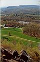
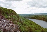
Chauncey Peak, 688 feet (209.7 m), is a traprock mountain located 2 miles (3 km) northeast of the center of Meriden, Connecticut
. It is part of the narrow, linear Metacomet Ridge
that extends from Long Island Sound
near New Haven, Connecticut
, north through the Connecticut River Valley of Massachusetts
to the Vermont
border. Chauncey Peak is known for its scenic vistas, vertical cliff faces overlooking Crescent Lake, unique microclimate
ecosystems, and rare plant communities. It rises steeply 400 feet (121.9 m) above the city of Meriden to the south with west-facing cliffs that plunge into Crescent Lake 300 feet (91.4 m) below.
The mountain is traversed by the 50 miles (80.5 km) Mattabesett Trail
.
. Although Chauncey Peak is described by some sources as part of Lamentation Mountain, it rises more than 300 feet (91.4 m) above the common gap between the two, making it its own mountain by regional standards (see Four-thousand footers
). Crescent Lake, (formerly called Bradley Hubbard Reservoir), lies nestled between Lamentation Mountain and Chauncey Peak. The lake provides emergency drinking water to the city of Meriden. Much of the east side of the mountain has been subject to quarrying; as of 2007, the quarry was .5 mi (.8k) wide, roughly 3/4ths the width of the entire mountain. Interstate 91
cuts through the gap between Higby Mountain and Chauncey Peak to the north.
The Metacomet Ridge continues north from Chauncey Peak to become Lamentation Mountain
and south to become Higby Mountain
. The western half of Chauncey Peak drains into the Quinnipiac River
, then to Long Island Sound; the eastern half to the Mattabesett River, thence to the Connecticut River
and Long Island Sound.
from Eurasia
in the process that would ultimately create the Atlantic Ocean
. In the area that is now the Metacomet Ridge and surrounding sedimentary rock basin, massive basalt (traprock) lava
flows spread across the prehistoric rift valley
, some of them several hundred feet thick, over a period of 20 million years. Sediment accumulated between lava flows and lithified into sedimentary rock
. After the rifting processes ceased, layers of strata faulted and tilted upward. Subsequent erosion
, glaciation, and uplift exposed the weather resistant edge of the traprock lava sheets, creating the cliffline of the Metacomet Ridge as it is today. The mineral content and the shape of the ridge make possible a variety of microclimate ecosystems. Hot and dry cliff faces support plant and animal species uncommon so far north. Deeply gouged ravines support cooler climate species found in more northerly climes, while gradual backslope environments support species typical of the surrounding latitude. Talus slopes beneath cliffs accumulate minerals that support alkaline-loving plant species uncommon in surrounding acidic southern New England. Extensive cliffs provide ideal habitat and important migration corridors for raptor species.
See Metacomet Ridge
for detailed information about the geology and ecosystem of Chauncey Peak.
, snowshoeing, cross-country skiing
, picnicking, and bicycling. Swimming, boating
, rock climbing
, and fishing
are prohibited. The park supports a number of trails, most notably the Mattabesett Trail (maintained by the Connecticut Forest and Park Association
), which stretches from the northern end of Lamentation Mountain, south to Totoket Mountain
and north again to the Connecticut River. Trailhead parking for Chauncey Peak is located at Giufridda Park on Westfield Road, 1.2 miles (1.9 km) east of its junction with U.S. Route 5
and 1.8 miles (2.9 km) west of Interstate 91
, exit 20, via Country Club Road (which becomes Westfield Road).
The ecosystem and ridgeline of Chauncey Peak is most threatened by quarrying, although the west side of the peak, within Giuffrida Park, is protected. In 2000, Chauncey Peak was included in a study by the National Park Service
for the designation of a new National Scenic Trail
now tentatively called the New England National Scenic Trail
, which would include the Metacomet-Monadnock Trail
in Massachusetts and the Mattabesett Trail
and Metacomet Trail
trails in Connecticut.
Meriden, Connecticut
Meriden is a city in New Haven County, Connecticut, United States. According to 2005 Census Bureau estimates, the population of the city is 59,653.-History:...
. It is part of the narrow, linear Metacomet Ridge
Metacomet Ridge
The Metacomet Ridge, Metacomet Ridge Mountains, or Metacomet Range of southern New England, United States, is a narrow and steep fault-block mountain ridge known for its extensive cliff faces, scenic vistas, microclimate ecosystems, and communities of plants considered rare or endangered...
that extends from Long Island Sound
Long Island Sound
Long Island Sound is an estuary of the Atlantic Ocean, located in the United States between Connecticut to the north and Long Island, New York to the south. The mouth of the Connecticut River at Old Saybrook, Connecticut, empties into the sound. On its western end the sound is bounded by the Bronx...
near New Haven, Connecticut
New Haven, Connecticut
New Haven is the second-largest city in Connecticut and the sixth-largest in New England. According to the 2010 Census, New Haven's population increased by 5.0% between 2000 and 2010, a rate higher than that of the State of Connecticut, and higher than that of the state's five largest cities, and...
, north through the Connecticut River Valley of Massachusetts
Massachusetts
The Commonwealth of Massachusetts is a state in the New England region of the northeastern United States of America. It is bordered by Rhode Island and Connecticut to the south, New York to the west, and Vermont and New Hampshire to the north; at its east lies the Atlantic Ocean. As of the 2010...
to the Vermont
Vermont
Vermont is a state in the New England region of the northeastern United States of America. The state ranks 43rd in land area, , and 45th in total area. Its population according to the 2010 census, 630,337, is the second smallest in the country, larger only than Wyoming. It is the only New England...
border. Chauncey Peak is known for its scenic vistas, vertical cliff faces overlooking Crescent Lake, unique microclimate
Microclimate
A microclimate is a local atmospheric zone where the climate differs from the surrounding area. The term may refer to areas as small as a few square feet or as large as many square miles...
ecosystems, and rare plant communities. It rises steeply 400 feet (121.9 m) above the city of Meriden to the south with west-facing cliffs that plunge into Crescent Lake 300 feet (91.4 m) below.
The mountain is traversed by the 50 miles (80.5 km) Mattabesett Trail
Mattabesett Trail
The Mattabesett Trail is a long, hook-shaped Blue-Blazed hiking trail in central Connecticut and a part of the newly designated New England National Scenic Trail. One half of the trail follows the high traprock ridges of the Metacomet Ridge, from Totoket Mountain in Guilford, Connecticut to...
.
Geography
Roughly 0.75 miles (1.2 km) in diameter, Chauncey Peak is located within the town of Meriden, ConnecticutMeriden, Connecticut
Meriden is a city in New Haven County, Connecticut, United States. According to 2005 Census Bureau estimates, the population of the city is 59,653.-History:...
. Although Chauncey Peak is described by some sources as part of Lamentation Mountain, it rises more than 300 feet (91.4 m) above the common gap between the two, making it its own mountain by regional standards (see Four-thousand footers
Four-thousand footers
The term Four-Thousand Footers refers to a group of forty-eight mountains in New Hampshire at least 4,000 feet above sea level...
). Crescent Lake, (formerly called Bradley Hubbard Reservoir), lies nestled between Lamentation Mountain and Chauncey Peak. The lake provides emergency drinking water to the city of Meriden. Much of the east side of the mountain has been subject to quarrying; as of 2007, the quarry was .5 mi (.8k) wide, roughly 3/4ths the width of the entire mountain. Interstate 91
Interstate 91
Interstate 91 is an Interstate Highway in the New England region of the United States. It provides the primary north–south thoroughfare in the western part of New England...
cuts through the gap between Higby Mountain and Chauncey Peak to the north.
The Metacomet Ridge continues north from Chauncey Peak to become Lamentation Mountain
Lamentation Mountain
Lamentation Mountain, or Mount Lamentation, , is a traprock mountain located north of Meriden, Connecticut. It is part of the narrow, linear Metacomet Ridge that extends from Long Island Sound near New Haven, Connecticut, north through the Connecticut River Valley of Massachusetts to the Vermont...
and south to become Higby Mountain
Higby Mountain
Higby Mountain or Mount Higby , is a traprock mountain ridge located east of Meriden, Connecticut. It is part of the narrow, linear Metacomet Ridge that extends from Long Island Sound near New Haven, Connecticut, north through the Connecticut River Valley of Massachusetts to the Vermont border...
. The western half of Chauncey Peak drains into the Quinnipiac River
Quinnipiac River
The Quinnipiac River is a river in the New England region of the United States, located entirely in the state of Connecticut.It rises in west central Connecticut from Dead Wood Swamp west of the city of New Britain...
, then to Long Island Sound; the eastern half to the Mattabesett River, thence to the Connecticut River
Connecticut River
The Connecticut River is the largest and longest river in New England, and also an American Heritage River. It flows roughly south, starting from the Fourth Connecticut Lake in New Hampshire. After flowing through the remaining Connecticut Lakes and Lake Francis, it defines the border between the...
and Long Island Sound.
Geology and environment
The origin of Chauncey Peak and the Metacomet Ridge dates back 200 million years ago with the rifting apart of North AmericaNorth America
North America is a continent wholly within the Northern Hemisphere and almost wholly within the Western Hemisphere. It is also considered a northern subcontinent of the Americas...
from Eurasia
Eurasia
Eurasia is a continent or supercontinent comprising the traditional continents of Europe and Asia ; covering about 52,990,000 km2 or about 10.6% of the Earth's surface located primarily in the eastern and northern hemispheres...
in the process that would ultimately create the Atlantic Ocean
Atlantic Ocean
The Atlantic Ocean is the second-largest of the world's oceanic divisions. With a total area of about , it covers approximately 20% of the Earth's surface and about 26% of its water surface area...
. In the area that is now the Metacomet Ridge and surrounding sedimentary rock basin, massive basalt (traprock) lava
Lava
Lava refers both to molten rock expelled by a volcano during an eruption and the resulting rock after solidification and cooling. This molten rock is formed in the interior of some planets, including Earth, and some of their satellites. When first erupted from a volcanic vent, lava is a liquid at...
flows spread across the prehistoric rift valley
Rift valley
A rift valley is a linear-shaped lowland between highlands or mountain ranges created by the action of a geologic rift or fault. This action is manifest as crustal extension, a spreading apart of the surface which is subsequently further deepened by the forces of erosion...
, some of them several hundred feet thick, over a period of 20 million years. Sediment accumulated between lava flows and lithified into sedimentary rock
Sedimentary rock
Sedimentary rock are types of rock that are formed by the deposition of material at the Earth's surface and within bodies of water. Sedimentation is the collective name for processes that cause mineral and/or organic particles to settle and accumulate or minerals to precipitate from a solution....
. After the rifting processes ceased, layers of strata faulted and tilted upward. Subsequent erosion
Erosion
Erosion is when materials are removed from the surface and changed into something else. It only works by hydraulic actions and transport of solids in the natural environment, and leads to the deposition of these materials elsewhere...
, glaciation, and uplift exposed the weather resistant edge of the traprock lava sheets, creating the cliffline of the Metacomet Ridge as it is today. The mineral content and the shape of the ridge make possible a variety of microclimate ecosystems. Hot and dry cliff faces support plant and animal species uncommon so far north. Deeply gouged ravines support cooler climate species found in more northerly climes, while gradual backslope environments support species typical of the surrounding latitude. Talus slopes beneath cliffs accumulate minerals that support alkaline-loving plant species uncommon in surrounding acidic southern New England. Extensive cliffs provide ideal habitat and important migration corridors for raptor species.
See Metacomet Ridge
Metacomet Ridge
The Metacomet Ridge, Metacomet Ridge Mountains, or Metacomet Range of southern New England, United States, is a narrow and steep fault-block mountain ridge known for its extensive cliff faces, scenic vistas, microclimate ecosystems, and communities of plants considered rare or endangered...
for detailed information about the geology and ecosystem of Chauncey Peak.
Recreation and conservation
The west side of Chauncey Peak lies within Giuffrida Park, managed by the city of Meriden. The park boasts a lake, golf course, woodlands, and the rocky peaks of Lamentation Mountain and Chauncey Peak. Permitted activities within the park include hikingHiking
Hiking is an outdoor activity which consists of walking in natural environments, often in mountainous or other scenic terrain. People often hike on hiking trails. It is such a popular activity that there are numerous hiking organizations worldwide. The health benefits of different types of hiking...
, snowshoeing, cross-country skiing
Cross-country skiing
Cross-country skiing is a winter sport in which participants propel themselves across snow-covered terrain using skis and poles...
, picnicking, and bicycling. Swimming, boating
Boating
Boating is the leisurely activity of travelling by boat, or the recreational use of a boat whether powerboats, sailboats, or man-powered vessels , focused on the travel itself, as well as sports activities, such as fishing or water skiing...
, rock climbing
Rock climbing
Rock climbing also lightly called 'The Gravity Game', is a sport in which participants climb up, down or across natural rock formations or artificial rock walls. The goal is to reach the summit of a formation or the endpoint of a pre-defined route without falling...
, and fishing
Fishing
Fishing is the activity of trying to catch wild fish. Fish are normally caught in the wild. Techniques for catching fish include hand gathering, spearing, netting, angling and trapping....
are prohibited. The park supports a number of trails, most notably the Mattabesett Trail (maintained by the Connecticut Forest and Park Association
Connecticut Forest and Park Association
The Connecticut Forest and Park Association , established in 1895, is the oldest private, nonprofit conservation organization in Connecticut. The organization is credited as an important early pioneer of the national land conservation movement and as an early advocate of long distance trail building...
), which stretches from the northern end of Lamentation Mountain, south to Totoket Mountain
Totoket Mountain
Totoket Mountain, with a high point of above sea level, is a traprock massif with several distinct summits, located northeast of New Haven, Connecticut. It is part of the Metacomet Ridge that extends from Long Island Sound near New Haven, north through the Connecticut River Valley of...
and north again to the Connecticut River. Trailhead parking for Chauncey Peak is located at Giufridda Park on Westfield Road, 1.2 miles (1.9 km) east of its junction with U.S. Route 5
U.S. Route 5
U.S. Route 5 is a north–south United States highway running through the New England states of Connecticut, Massachusetts, and Vermont. Significant cities along the route include New Haven, Connecticut; Hartford, Connecticut; and Springfield, Massachusetts. From Hartford northward to St...
and 1.8 miles (2.9 km) west of Interstate 91
Interstate 91
Interstate 91 is an Interstate Highway in the New England region of the United States. It provides the primary north–south thoroughfare in the western part of New England...
, exit 20, via Country Club Road (which becomes Westfield Road).
The ecosystem and ridgeline of Chauncey Peak is most threatened by quarrying, although the west side of the peak, within Giuffrida Park, is protected. In 2000, Chauncey Peak was included in a study by the National Park Service
National Park Service
The National Park Service is the U.S. federal agency that manages all national parks, many national monuments, and other conservation and historical properties with various title designations...
for the designation of a new National Scenic Trail
National Scenic Trail
National Scenic Trail is a designation for protected areas in the United States that consist of trails of particular natural beauty.National Scenic Trails were authorized under the National Trails System Act of 1968 along with National Historic Trails and National Recreation Trails...
now tentatively called the New England National Scenic Trail
New England National Scenic Trail
The New England National Scenic Trail is a National Scenic Trail in southern New England, which includes most of the three single trails Metacomet-Monadnock Trail, Mattabesett Trail and Metacomet Trail. After the Metacomet-Monadnock-Mattabesett trail system, the trail is sometimes called Triple-M...
, which would include the Metacomet-Monadnock Trail
Metacomet-Monadnock Trail
The Metacomet-Monadnock Trail is a hiking trail that traverses the Metacomet Ridge of the Pioneer Valley region of Massachusetts and the central uplands of Massachusetts and southern New Hampshire...
in Massachusetts and the Mattabesett Trail
Mattabesett Trail
The Mattabesett Trail is a long, hook-shaped Blue-Blazed hiking trail in central Connecticut and a part of the newly designated New England National Scenic Trail. One half of the trail follows the high traprock ridges of the Metacomet Ridge, from Totoket Mountain in Guilford, Connecticut to...
and Metacomet Trail
Metacomet Trail
The Metacomet Trail is a Blue-Blazed hiking trail that traverses the Metacomet Ridge of central Connecticut and is a part of the newly designated New England National Scenic Trail. Despite being easily accessible and close to large population centers, the trail is considered remarkably rugged and...
trails in Connecticut.
See also
- Metacomet RidgeMetacomet RidgeThe Metacomet Ridge, Metacomet Ridge Mountains, or Metacomet Range of southern New England, United States, is a narrow and steep fault-block mountain ridge known for its extensive cliff faces, scenic vistas, microclimate ecosystems, and communities of plants considered rare or endangered...
- Adjacent summits:
↓ South North ↑