

List of Metacomet Ridge summits
Encyclopedia
The following is a list of the more notable summits and sub–ranges that make up the crest of the Metacomet Ridge
, a fault-block landform located in Connecticut
and Massachusetts
, known for its microclimate
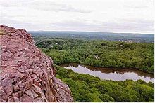
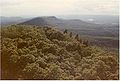
ecosystems, rare plant communities, scenic vistas, proximity to major urban centers, and recreational opportunities.
In southern Connecticut, the Metacomet Ridge consists of two parallel ridges; the western ridge terminates near Meriden, Connecticut
while the eastern ridge continues north into Massachusetts proximal to the Connecticut River
. Notable summits with elevations are included below, listed from south to north.
In Connecticut:
West ridgeline

East ridgeline

In Massachusetts
* Estimated elevation accurate within
Metacomet Ridge
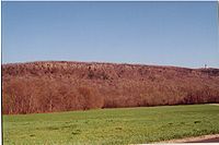
The Metacomet Ridge, Metacomet Ridge Mountains, or Metacomet Range of southern New England, United States, is a narrow and steep fault-block mountain ridge known for its extensive cliff faces, scenic vistas, microclimate ecosystems, and communities of plants considered rare or endangered...
, a fault-block landform located in Connecticut
Connecticut
Connecticut is a state in the New England region of the northeastern United States. It is bordered by Rhode Island to the east, Massachusetts to the north, and the state of New York to the west and the south .Connecticut is named for the Connecticut River, the major U.S. river that approximately...
and Massachusetts
Massachusetts
The Commonwealth of Massachusetts is a state in the New England region of the northeastern United States of America. It is bordered by Rhode Island and Connecticut to the south, New York to the west, and Vermont and New Hampshire to the north; at its east lies the Atlantic Ocean. As of the 2010...
, known for its microclimate
Microclimate
A microclimate is a local atmospheric zone where the climate differs from the surrounding area. The term may refer to areas as small as a few square feet or as large as many square miles...
ecosystems, rare plant communities, scenic vistas, proximity to major urban centers, and recreational opportunities.
In southern Connecticut, the Metacomet Ridge consists of two parallel ridges; the western ridge terminates near Meriden, Connecticut
Meriden, Connecticut
Meriden is a city in New Haven County, Connecticut, United States. According to 2005 Census Bureau estimates, the population of the city is 59,653.-History:...
while the eastern ridge continues north into Massachusetts proximal to the Connecticut River
Connecticut River
The Connecticut River is the largest and longest river in New England, and also an American Heritage River. It flows roughly south, starting from the Fourth Connecticut Lake in New Hampshire. After flowing through the remaining Connecticut Lakes and Lake Francis, it defines the border between the...
. Notable summits with elevations are included below, listed from south to north.
In Connecticut:
West ridgeline
| Name | Elevation | Location |
| East Rock East Rock East Rock of south-central Connecticut, United States, with a high point of , is a long trap rock ridge located on the north side of the city of New Haven... |
366 ft (112 m) | New Haven New Haven, Connecticut New Haven is the second-largest city in Connecticut and the sixth-largest in New England. According to the 2010 Census, New Haven's population increased by 5.0% between 2000 and 2010, a rate higher than that of the State of Connecticut, and higher than that of the state's five largest cities, and... and Hamden Hamden, Connecticut Hamden is a town in New Haven County, Connecticut, United States. The town's nickname is "The Land of the Sleeping Giant." Hamden is home to Quinnipiac University. The population was 58,180 according to the Census Bureau's 2005 estimates... |
| West Rock Ridge West Rock Ridge West Rock Ridge or West Rock of south-central Connecticut, with a high point of , is a long trap rock mountain ridge located on the west side of New Haven. The ridge forms a continuous line of exposed cliffs visible from metropolitan New Haven and points west... |
700 ft (213 m) * | New Haven New Haven, Connecticut New Haven is the second-largest city in Connecticut and the sixth-largest in New England. According to the 2010 Census, New Haven's population increased by 5.0% between 2000 and 2010, a rate higher than that of the State of Connecticut, and higher than that of the state's five largest cities, and... , Hamden Hamden, Connecticut Hamden is a town in New Haven County, Connecticut, United States. The town's nickname is "The Land of the Sleeping Giant." Hamden is home to Quinnipiac University. The population was 58,180 according to the Census Bureau's 2005 estimates... , Woodbridge Woodbridge, Connecticut Woodbridge is a town in New Haven County, Connecticut, United States. The population was 8,983 at the 2000 census. It is one of the wealthiest towns in Connecticut, ranking 16th in the state in terms of per capita income, and is home to many of the faculty of Yale University... , and Bethany Bethany, Connecticut Bethany is a town in New Haven County, Connecticut, United States. The population was 5,040 at the 2000 census. Bethany was first settled in 1717 but it was not until May 1832 that Bethany separated from Woodbridge to become incorporated as a town. This slightly remote, sparsely populated,... |
| Sleeping Giant Sleeping Giant (Connecticut) Sleeping Giant of south-central Connecticut, with a high point of , is a rugged traprock mountain located north of New Haven. It is part of the narrow, linear Metacomet Ridge that extends from Long Island Sound near New Haven, north through the Connecticut River Valley of Massachusetts to the... |
739 ft (225 m) | Hamden Hamden, Connecticut Hamden is a town in New Haven County, Connecticut, United States. The town's nickname is "The Land of the Sleeping Giant." Hamden is home to Quinnipiac University. The population was 58,180 according to the Census Bureau's 2005 estimates... and Wallingford Wallingford, Connecticut Wallingford is a town in New Haven County, Connecticut, United States. The population was 43,026 at the 2000 census.- History :Wallingford was established on October 10, 1667, when the Connecticut General Assembly authorized the "making of a village on the east river" to 38 planters and freemen... |
| Mount Sanford Mount Sanford (Connecticut) Mount Sanford of south-central Connecticut, est. , is the high point on a long traprock mountain ridge located northwest of the city of New Haven. Mount Sanford is part of the narrow, linear Metacomet Ridge that extends from Long Island Sound near New Haven, north through the Connecticut River... |
880 ft (270 m) * | Hamden Hamden, Connecticut Hamden is a town in New Haven County, Connecticut, United States. The town's nickname is "The Land of the Sleeping Giant." Hamden is home to Quinnipiac University. The population was 58,180 according to the Census Bureau's 2005 estimates... , Bethany Bethany, Connecticut Bethany is a town in New Haven County, Connecticut, United States. The population was 5,040 at the 2000 census. Bethany was first settled in 1717 but it was not until May 1832 that Bethany separated from Woodbridge to become incorporated as a town. This slightly remote, sparsely populated,... , and Cheshire Cheshire, Connecticut Cheshire is a town in New Haven County, Connecticut, United States. The population was 28,543 at the 2000 census. The center of population of Connecticut is located in Cheshire. In 2009 Cheshire was ranked 72 in Money Magazine's 100 Best Places to Live.Likewise, in 2011 Cheshire was ranked 73 in... |
| Peck Mountain | 431 ft (131 m) | Cheshire Cheshire, Connecticut Cheshire is a town in New Haven County, Connecticut, United States. The population was 28,543 at the 2000 census. The center of population of Connecticut is located in Cheshire. In 2009 Cheshire was ranked 72 in Money Magazine's 100 Best Places to Live.Likewise, in 2011 Cheshire was ranked 73 in... |
East ridgeline
| Name | Elevation | Location |
| Beacon Hill Beacon Hill (Branford, Connecticut) Beacon Hill, above sea level, is a traprock outcrop located southeast of New Haven, Connecticut overlooking the mouth of the East Haven River 1.2 miles north of Long Island Sound... |
130 ft (40 m) * | Branford Branford, Connecticut -Landmarks and attractions:Branford has six historic districts that are listed on the U.S. National Register of Historic Places . These include buildings in Federal, Arts and Crafts, and Queen Anne styles of architecture... |
| Saltonstall Mountain Saltonstall Mountain Saltonstall Mountain, also known as Saltonstall Ridge, with a high point of above sea level, is a traprock mountain ridge located east of New Haven, Connecticut and north of Long Island Sound. It is part of the Metacomet Ridge that extends from Long Island Sound near New Haven, Connecticut,... |
320 ft (98 m) * | Branford Branford, Connecticut -Landmarks and attractions:Branford has six historic districts that are listed on the U.S. National Register of Historic Places . These include buildings in Federal, Arts and Crafts, and Queen Anne styles of architecture... , North Branford North Branford, Connecticut North Branford is a town in New Haven County, Connecticut, United States. The population was 13,906 at the 2000 census.-Geography:According to the United States Census Bureau, the town has a total area of 26.6 square miles , of which 24.9 square miles is land and 1.7 square miles is water... , and East Haven East Haven, Connecticut East Haven is a town in New Haven County, Connecticut, in the United States. As of the 2000 census, the town population was 28,189. The town is just 3 minutes from downtown New Haven... |
| Peter's Rock Peter's Rock Peter's Rock, also known as Rabbit Rock, Rabbit Hill, Indian Rock and Great Rock, with a high point of above sea level, is a trap rock peak located northeast of downtown New Haven, Connecticut in the town of North Haven... |
373 ft (114 m) | North Haven North Haven, Connecticut North Haven is a town in New Haven County, Connecticut on the outskirts of New Haven, Connecticut.North Haven is less than ten miles from downtown New Haven and Yale University. It is near Sleeping Giant State Park and home the Quinnipiac University School of Health Sciences, the School of Nursing,... |
| Totoket Mountain Totoket Mountain Totoket Mountain, with a high point of above sea level, is a traprock massif with several distinct summits, located northeast of New Haven, Connecticut. It is part of the Metacomet Ridge that extends from Long Island Sound near New Haven, north through the Connecticut River Valley of... |
720 ft (219 m) * | North Branford North Branford, Connecticut North Branford is a town in New Haven County, Connecticut, United States. The population was 13,906 at the 2000 census.-Geography:According to the United States Census Bureau, the town has a total area of 26.6 square miles , of which 24.9 square miles is land and 1.7 square miles is water... , Durham Durham, Connecticut Durham is a town in Middlesex County, Connecticut, United States. Durham is a former farming village on the Coginchaug River in central Connecticut. The population was 6,627 at the 2000 census. Every autumn, the town hosts the Durham Fair, the largest volunteer agricultural fair in New... , and Guilford Guilford, Connecticut Guilford is a town in New Haven County, Connecticut, United States, that borders Madison, Branford, North Branford and Durham, and is situated on I-95 and the coast. The population was 21,398 at the 2000 census... |
| Pistapaug Mountain Pistapaug Mountain Pistapaug Mountain, also known as Paug Mountain, est. , is a traprock mountain located northeast of New Haven, Connecticut. It is part of the narrow, linear Metacomet Ridge that extends from Long Island Sound near New Haven, Connecticut, north through the Connecticut River Valley of Massachusetts... |
700 ft (213 m) * | Durham Durham, Connecticut Durham is a town in Middlesex County, Connecticut, United States. Durham is a former farming village on the Coginchaug River in central Connecticut. The population was 6,627 at the 2000 census. Every autumn, the town hosts the Durham Fair, the largest volunteer agricultural fair in New... |
| Fowler Mountain Fowler Mountain Fowler Mountain, est. , is a traprock mountain located southeast of the center of Meriden, Connecticut. It is part of the narrow, linear Metacomet Ridge that extends from Long Island Sound near New Haven, Connecticut, north through the Connecticut River Valley of Massachusetts to the Vermont border... |
750 ft (229 m) | Wallingford Wallingford, Connecticut Wallingford is a town in New Haven County, Connecticut, United States. The population was 43,026 at the 2000 census.- History :Wallingford was established on October 10, 1667, when the Connecticut General Assembly authorized the "making of a village on the east river" to 38 planters and freemen... |
| Trimountain Trimountain Trimountain or Tri-mountain, est. , is a traprock mountain located southeast of Meriden, Connecticut. It is part of the narrow, linear Metacomet Ridge that extends from Long Island Sound near New Haven, Connecticut, north through the Connecticut River Valley of Massachusetts to the Vermont border... |
760 ft (232 m) * | Durham Durham, Connecticut Durham is a town in Middlesex County, Connecticut, United States. Durham is a former farming village on the Coginchaug River in central Connecticut. The population was 6,627 at the 2000 census. Every autumn, the town hosts the Durham Fair, the largest volunteer agricultural fair in New... and Wallingford Wallingford, Connecticut Wallingford is a town in New Haven County, Connecticut, United States. The population was 43,026 at the 2000 census.- History :Wallingford was established on October 10, 1667, when the Connecticut General Assembly authorized the "making of a village on the east river" to 38 planters and freemen... |
| Besek Mountain Besek Mountain Besek Mountain also known as Black Mountain, est. , is a traprock mountain ridge located southeast of Meriden, Connecticut. It is part of the narrow, linear Metacomet Ridge that extends from Long Island Sound near New Haven, Connecticut, north through the Connecticut River Valley of Massachusetts... |
840 ft (256 m) * | Meriden Meriden, Connecticut Meriden is a city in New Haven County, Connecticut, United States. According to 2005 Census Bureau estimates, the population of the city is 59,653.-History:... , Wallingford Wallingford, Connecticut Wallingford is a town in New Haven County, Connecticut, United States. The population was 43,026 at the 2000 census.- History :Wallingford was established on October 10, 1667, when the Connecticut General Assembly authorized the "making of a village on the east river" to 38 planters and freemen... , and Middlefield Middlefield, Connecticut Middlefield is a town in Middlesex County, Connecticut, United States. The population was 4,203 at the 2000 census. The town includes the village of Rockfall-History:... |
| Higby Mountain Higby Mountain Higby Mountain or Mount Higby , is a traprock mountain ridge located east of Meriden, Connecticut. It is part of the narrow, linear Metacomet Ridge that extends from Long Island Sound near New Haven, Connecticut, north through the Connecticut River Valley of Massachusetts to the Vermont border... |
892 ft (272 m) | Middlefield Middlefield, Connecticut Middlefield is a town in Middlesex County, Connecticut, United States. The population was 4,203 at the 2000 census. The town includes the village of Rockfall-History:... and Middletown Middletown, Connecticut Middletown is a city located in Middlesex County, Connecticut, along the Connecticut River, in the central part of the state, 16 miles south of Hartford. In 1650, it was incorporated as a town under its original Indian name, Mattabeseck. It received its present name in 1653. In 1784, the central... |
| Chauncey Peak Chauncey Peak Chauncey Peak, , is a traprock mountain located 2 miles northeast of the center of Meriden, Connecticut. It is part of the narrow, linear Metacomet Ridge that extends from Long Island Sound near New Haven, Connecticut, north through the Connecticut River Valley of Massachusetts to the Vermont border... |
688 ft (210 m) | Meriden Meriden, Connecticut Meriden is a city in New Haven County, Connecticut, United States. According to 2005 Census Bureau estimates, the population of the city is 59,653.-History:... |
| Lamentation Mountain Lamentation Mountain Lamentation Mountain, or Mount Lamentation, , is a traprock mountain located north of Meriden, Connecticut. It is part of the narrow, linear Metacomet Ridge that extends from Long Island Sound near New Haven, Connecticut, north through the Connecticut River Valley of Massachusetts to the Vermont... |
720 ft (219 m) | Berlin Berlin, Connecticut Berlin is a town in Hartford County, Connecticut, United States. The population was 19,866 at the 2010 census. It was incorporated in 1785. The geographic center of Connecticut is located in the town. Berlin is residential and industrial, and served by the Amtrak station of the same name... , Middletown Middletown, Connecticut Middletown is a city located in Middlesex County, Connecticut, along the Connecticut River, in the central part of the state, 16 miles south of Hartford. In 1650, it was incorporated as a town under its original Indian name, Mattabeseck. It received its present name in 1653. In 1784, the central... , and Meriden Meriden, Connecticut Meriden is a city in New Haven County, Connecticut, United States. According to 2005 Census Bureau estimates, the population of the city is 59,653.-History:... |
| The Hanging Hills Hanging Hills The Hanging Hills of south central Connecticut, USA are a range of mountainous trap rock ridges overlooking the city of Meriden and the Quinnipiac River Valley below. They are a sub-range of the narrow, linear Metacomet Ridge that extends from Long Island Sound near New Haven, Connecticut, north... |
1,024 ft (312 m) | Berlin Berlin, Connecticut Berlin is a town in Hartford County, Connecticut, United States. The population was 19,866 at the 2010 census. It was incorporated in 1785. The geographic center of Connecticut is located in the town. Berlin is residential and industrial, and served by the Amtrak station of the same name... , Meriden Meriden, Connecticut Meriden is a city in New Haven County, Connecticut, United States. According to 2005 Census Bureau estimates, the population of the city is 59,653.-History:... , and Southington Southington, Connecticut Southington is a town in Hartford County, Connecticut, United States. It is part of Connecticut's 1st congressional district. It is situated about 20 miles southwest of Hartford, about 80 miles northeast of New York City, 105 miles southwest of Boston and 77 miles west of Providence... |
| Short Mountain Short Mountain (Connecticut) Short Mountain is a traprock mountain located in south central Connecticut north of the city of Meriden. It is part of the narrow Metacomet Ridge that extends from Long Island Sound near New Haven, Connecticut, north through the Connecticut River Valley of Massachusetts to the Vermont border... |
530 ft (162 m) | Berlin Berlin, Connecticut Berlin is a town in Hartford County, Connecticut, United States. The population was 19,866 at the 2010 census. It was incorporated in 1785. The geographic center of Connecticut is located in the town. Berlin is residential and industrial, and served by the Amtrak station of the same name... and Southington Southington, Connecticut Southington is a town in Hartford County, Connecticut, United States. It is part of Connecticut's 1st congressional district. It is situated about 20 miles southwest of Hartford, about 80 miles northeast of New York City, 105 miles southwest of Boston and 77 miles west of Providence... |
| Ragged Mountain | 761 ft (232 m) | Berlin Berlin, Connecticut Berlin is a town in Hartford County, Connecticut, United States. The population was 19,866 at the 2010 census. It was incorporated in 1785. The geographic center of Connecticut is located in the town. Berlin is residential and industrial, and served by the Amtrak station of the same name... and Southington Southington, Connecticut Southington is a town in Hartford County, Connecticut, United States. It is part of Connecticut's 1st congressional district. It is situated about 20 miles southwest of Hartford, about 80 miles northeast of New York City, 105 miles southwest of Boston and 77 miles west of Providence... |
| Bradley Mountain Bradley Mountain Bradley Mountain, , is a traprock mountain located west of New Britain, Connecticut, USA, in the town of Southington and PlainvilleIt is part of the narrow, linear Metacomet Ridge that extends from Long Island Sound near New Haven, Connecticut, north through the Connecticut River Valley of... |
700 ft (213 m) | Plainville Plainville, Connecticut Plainville is a town in Hartford County, Connecticut, United States. The population was 17,328 at the 2000 census.-Geography:According to the United States Census Bureau, the town has a total area of 9.8 square miles , of which 9.8 square miles is land and 0.1 square miles is water... and Southington Southington, Connecticut Southington is a town in Hartford County, Connecticut, United States. It is part of Connecticut's 1st congressional district. It is situated about 20 miles southwest of Hartford, about 80 miles northeast of New York City, 105 miles southwest of Boston and 77 miles west of Providence... |
| Pinnacle Rock Pinnacle Rock (Connecticut) Pinnacle Rock, , is a traprock mountain peak located southwest of Hartford, Connecticut in the towns of Farmington and Plainville.It is part of the narrow, linear Metacomet Ridge that extends from Long Island Sound near New Haven, Connecticut, north through the Connecticut River Valley of... |
600 ft (183 m) | Plainville Plainville, Connecticut Plainville is a town in Hartford County, Connecticut, United States. The population was 17,328 at the 2000 census.-Geography:According to the United States Census Bureau, the town has a total area of 9.8 square miles , of which 9.8 square miles is land and 0.1 square miles is water... and Farmington Farmington, Connecticut Farmington is a town located in Hartford County in the Farmington Valley area of central Connecticut in the United States. The population was 25,340 at the 2010 census. It is home to the world headquarters of several large corporations including Carrier Corporation, Otis Elevator Company, and Carvel... |
| Rattlesnake Mountain Rattlesnake Mountain (Connecticut) Rattlesnake Mountain is a traprock mountain, above sea level, located southwest of Hartford, Connecticut in the town of Farmington. It is part of the narrow, linear Metacomet Ridge that extends from Long Island Sound near New Haven, Connecticut, north through the Connecticut River Valley of... |
750 ft (229 m) | Farmington Farmington, Connecticut Farmington is a town located in Hartford County in the Farmington Valley area of central Connecticut in the United States. The population was 25,340 at the 2010 census. It is home to the world headquarters of several large corporations including Carrier Corporation, Otis Elevator Company, and Carvel... |
| Farmington Mountain Farmington Mountain Farmington Mountain, , is a traprock ridge located southwest of Hartford, Connecticut in the town of Farmington. It is part of the narrow, linear Metacomet Ridge that extends from Long Island Sound near New Haven, Connecticut, north through the Connecticut River Valley of Massachusetts to the... |
530 ft (162 m) | Farmington Farmington, Connecticut Farmington is a town located in Hartford County in the Farmington Valley area of central Connecticut in the United States. The population was 25,340 at the 2010 census. It is home to the world headquarters of several large corporations including Carrier Corporation, Otis Elevator Company, and Carvel... |
| Talcott Mountain Talcott Mountain Talcott Montain of central Connecticut, with a high point of , is a long trap rock mountain ridge located west of the city of Hartford. The ridge, a prominent landscape feature, forms a continuous line of exposed western cliffs visible across the Farmington River valley from Farmington to Simsbury... |
950 ft (290 m)* | West Hartford West Hartford, Connecticut West Hartford is a town located in Hartford County, Connecticut, United States. The town was incorporated in 1854. Prior to that date, the town was a parish of Hartford.... , Farmington Farmington, Connecticut Farmington is a town located in Hartford County in the Farmington Valley area of central Connecticut in the United States. The population was 25,340 at the 2010 census. It is home to the world headquarters of several large corporations including Carrier Corporation, Otis Elevator Company, and Carvel... , Avon Avon, Connecticut Avon is a town in the Farmington Valley region of Hartford County, Connecticut, United States. , the town had a population of 18,098.Avon is a suburb of Hartford. Avon Old Farms School, a prestigious boarding school, is located there. In 2005, Avon was named the third-safest town in America by... , Bloomfield Bloomfield, Connecticut Bloomfield is a town in Hartford County, Connecticut, United States. The population was 20,626 at the 2009 census.-Geography:According to the United States Census Bureau, the town has a total area of , of which is land and 0.2 square miles is water.Bloomfield is bordered by Windsor to the... , and Simsbury Simsbury, Connecticut Simsbury is a suburban town in Hartford County, Connecticut, United States. The population was 23,234 at the 2000 census. The town was incorporated as Connecticut's twenty-first town in May 1670.-Early history:... |
| Hatchet Hill Hatchet Hill Hatchet Hill, est. , is a trap rock ridge located in East Granby, Connecticut, northeast of Hartford, Connecticut. It is part of the narrow, linear Metacomet Ridge that extends from Long Island Sound near New Haven, Connecticut, north through the Connecticut River Valley of Massachusetts to the... |
510 ft (155 m) | East Granby East Granby, Connecticut East Granby is a town in Hartford County, Connecticut, United States. The population was estimated at 5,058 in 2005. The town recently celebrated its 150th anniversary with a three-day festival on June 7, 8, and 9, 2008.-Geography:... |
| Peak Mountain Peak Mountain Peak Mountain, also called Copper Mountain, est. , is a traprock mountain located in East Granby, Connecticut, south of the Massachusetts border and 6 miles west of the Connecticut River... |
730 ft (223 m) | East Granby East Granby, Connecticut East Granby is a town in Hartford County, Connecticut, United States. The population was estimated at 5,058 in 2005. The town recently celebrated its 150th anniversary with a three-day festival on June 7, 8, and 9, 2008.-Geography:... |
| Barn Door Hills Barn Door Hills The Barn Door Hills of north-central Connecticut are a pair of prominent rocky trap rock knobs separated by a steep sided gap. They are located in Granby, Connecticut. The hills are an outlying section of the narrow, linear Metacomet Ridge that extends from Long Island Sound near New Haven, north... |
580 ft (177 m) * | Granby Granby, Connecticut Granby is a town in Hartford County, Connecticut, United States. The population was 10,347 at the 2000 census. The town center was defined as a census-designated place known as Salmon Brook in the 2000 census.... |
| West Suffield Mountain West Suffield Mountain West Suffield Mountain, est. , is a traprock mountain ridge located between the Berkshires and the Connecticut River Valley in north-central Connecticut. It is part of the narrow, linear Metacomet Ridge that extends from Long Island Sound near New Haven, Connecticut, north through the Connecticut... |
710 ft (216 m) | Suffield Suffield, Connecticut Suffield is a town in Hartford County, Connecticut, United States. It had once been within the boundaries of Massachusetts. The town is located in the Connecticut River Valley with the town of Enfield neighboring to the east. In 1900, 3,521 people lived in Suffield; and in 1910, 3,841. As of the... |
| Manitook Mountain Manitook Mountain Manitook Mountain, also called Manituck Mountain, , is a long traprock mountain ridge located between the Berkshires and the Connecticut River Valley in north-central Connecticut... |
638 ft (194 m) | Granby Granby, Connecticut Granby is a town in Hartford County, Connecticut, United States. The population was 10,347 at the 2000 census. The town center was defined as a census-designated place known as Salmon Brook in the 2000 census.... |
In Massachusetts
| Name | Elevation | Location |
| Provin Mountain Provin Mountain Provin Mountain is a very narrow traprock mountain ridge located in the Connecticut River Valley of Massachusetts. It is part of the Metacomet Ridge which extends from Long Island Sound near New Haven, Connecticut, north through the Connecticut River Valley of Massachusetts to the Vermont border... |
600 ft (183 m) | Southwick Southwick, Massachusetts Southwick is a town in Hampden County, Massachusetts, United States. The population was 9,502 at the 2010 census. It is part of the Springfield, Massachusetts Metropolitan Statistical Area.- History :... , Agawam Agawam, Massachusetts The Town of Agawam is a city in Hampden County, Massachusetts, United States. The population was 28,438 at the 2010 census. Agawam sits on the western side of the Connecticut River, directly across from the City of Springfield, Massachusetts... , and Westfield Westfield, Massachusetts Westfield is a city in Hampden County, in the Pioneer Valley of western Massachusetts, United States. It is part of the Springfield, Massachusetts Metropolitan Statistical Area. The population was 41,094 at the 2010 census. The ZIP Code is 01085 for homes and businesses, 01086 for Westfield State... |
| East Mountain East Mountain (Hampden County, Massachusetts) East Mountain is a traprock mountain ridge located in the Connecticut River Valley of Massachusetts. It is part of the narrow, linear Metacomet Ridge that extends from Long Island Sound near New Haven, Connecticut, north through the Connecticut River Valley of Massachusetts to the Vermont border... |
776 ft (237 m) | Holyoke Holyoke, Massachusetts Holyoke is a city in Hampden County, Massachusetts, United States, between the western bank of the Connecticut River and the Mount Tom Range of mountains. As of the 2010 Census, the city had a population of 39,880... , West Springfield West Springfield, Massachusetts The Town of West Springfield is a city in Hampden County, Massachusetts, United States. It is part of the Springfield, Massachusetts Metropolitan Statistical Area. The population was 28,391 at the 2010 census... , and Westfield Westfield, Massachusetts Westfield is a city in Hampden County, in the Pioneer Valley of western Massachusetts, United States. It is part of the Springfield, Massachusetts Metropolitan Statistical Area. The population was 41,094 at the 2010 census. The ZIP Code is 01085 for homes and businesses, 01086 for Westfield State... |
| Mount Tom Range Mount Tom Range The Mount Tom Range is a traprock mountain range located in the Connecticut River Valley of Massachusetts. It is part of the Metacomet Ridge that extends from Long Island Sound near New Haven, Connecticut, north through the Connecticut River Valley of Massachusetts to nearly the Vermont border... |
1202 ft (363 m) | Holyoke Holyoke, Massachusetts Holyoke is a city in Hampden County, Massachusetts, United States, between the western bank of the Connecticut River and the Mount Tom Range of mountains. As of the 2010 Census, the city had a population of 39,880... and Easthampton Easthampton, Massachusetts Easthampton is the second largest city in Hampshire County, Massachusetts, United States. The town is on the southeastern edge of an area called the Pioneer Valley near the five colleges in the college towns of Northampton and Amherst, MA... |
| Holyoke Range Holyoke Range The Holyoke Range or Mount Holyoke Range is a traprock mountain range located in the Connecticut River Valley of Massachusetts. It is a sub-range of the narrow, linear Metacomet Ridge that extends from Long Island Sound near New Haven, Connecticut north through the Connecticut River Valley of... |
1106 ft (337 m) | Hadley Hadley, Massachusetts Hadley is a town in Hampshire County, Massachusetts. The population was 4,793 at the 2000 census. It is part of the Springfield, Massachusetts Metropolitan Statistical Area. The area around Hampshire Mall and Mountain Farms Mall along Route 9 is a major shopping destination for the surrounding... , South Hadley South Hadley, Massachusetts South Hadley is a town in Hampshire County, Massachusetts, United States. The population was 17,514 at the 2010 census. It is part of the Springfield, Massachusetts Metropolitan Statistical Area.... , Granby Granby, Massachusetts Granby is a town in Hampshire County, Massachusetts, United States. The population was 6,420 at the 2010 census.It is part of the Springfield, Massachusetts Metropolitan Statistical Area.Part of the town is comprised in the census-designated place of Granby.... , Amherst Amherst, Massachusetts Amherst is a town in Hampshire County, Massachusetts, United States in the Connecticut River valley. As of the 2010 census, the population was 37,819, making it the largest community in Hampshire County . The town is home to Amherst College, Hampshire College, and the University of Massachusetts... , and Belchertown Belchertown, Massachusetts As of the census of 2000, there were 12,968 people, 4,886 households, and 3,517 families residing in the town. The population density was 245.9 people per square mile . There were 5,050 housing units at an average density of 95.8 per square mile... |
| Mount Toby Mount Toby Mount Toby, , is the highest summit of a sprawling collection of mostly wooded hills and knolls that rise from a distinct plateau-like upland in the towns of Sunderland and Leverett, Massachusetts, just east of the Connecticut River. This mountain mass, part of the Metacomet Ridge geology, is oval... |
1269 ft (387 m) | Sunderland Sunderland, Massachusetts Sunderland is a town in Franklin County, Massachusetts, part of the Pioneer Valley. The population was 3,777 as of the 2000 census. It is part of the Springfield, Massachusetts Metropolitan Statistical Area.... and Leverett Leverett, Massachusetts Leverett is a town in Franklin County, Massachusetts, United States. The population was 1,663 as of the 2000 census. It is part of the Springfield, Massachusetts Metropolitan Statistical Area.- History :... |
| Sugarloaf Mountain Sugarloaf Mountain (Franklin County, Massachusetts) Sugarloaf Mountain or Mount Sugarloaf, is a butte-like mountain located in Deerfield, Massachusetts, United States, with two summits, North Sugarloaf Mountain and its more popular knee, South Sugarloaf Mountain . Its cliffs, made of arkose sandstone, are a very prominent landscape feature visible... |
791 ft (241 m) | Deerfield Deerfield, Massachusetts Deerfield is a town in Franklin County, Massachusetts, United States. The population was 4,750 as of the 2000 census. Deerfield is part of the Springfield, Massachusetts Metropolitan Statistical Area in Western Massachusetts, lying only north of the city of Springfield.Deerfield includes the... |
| Pocumtuck Range Pocumtuck Range The Pocumtuck Range, also referred to as the Pocumtuck Ridge, is the northern-most subrange of the Metacomet Ridge mountain range of southern New England... |
846 ft (258 m) | Deerfield Deerfield, Massachusetts Deerfield is a town in Franklin County, Massachusetts, United States. The population was 4,750 as of the 2000 census. Deerfield is part of the Springfield, Massachusetts Metropolitan Statistical Area in Western Massachusetts, lying only north of the city of Springfield.Deerfield includes the... and Greenfield Greenfield, Massachusetts Greenfield is a city in Franklin County, Massachusetts, United States. The population was 17,456 at the 2010 census. It is the county seat of Franklin County. Greenfield is home to Greenfield Community College, the Pioneer Valley Symphony Orchestra, and the Franklin County Fair... |