

Provin Mountain
Encyclopedia
Provin Mountain is a very narrow traprock mountain ridge located in the Connecticut River Valley of Massachusetts
. It is part of the Metacomet Ridge
which extends from Long Island Sound
near New Haven, Connecticut
, north through the Connecticut River Valley of Massachusetts
to the Vermont
border. Provin Mountain is known for its scenic cliffs, unique microclimate
ecosystems, and rare plant communities. It is traversed by the 110 miles (177 km) Metacomet-Monadnock Trail
.
and Westfield River
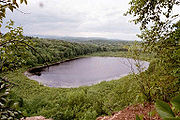
below, with a high point of 600 feet (183 m) above sea level. It is roughly 5 miles (8 km) long but is not much more than 0.5 miles (804.7 m) wide at its widest point, although the steepness of the terrain makes the actual square mileage much larger.
The Provin Mountain ridgeline extends from the Connecticut
border (near the Suffield
hamlet of Rising Corner) to the Westfield River
on the tri-border of Westfield
, West Springfield
, and Agawam, Massachusetts
; it lies within the towns of Southwick
, Agawam, and Westfield. The Metacomet Ridge continues north from the Westfield River as East Mountain
and continues south into Connecticut as West Suffield Mountain
. The south side of the mountain drains into the Connecticut River, thence to Long Island Sound; the rest of the mountain drains into the Westfield River, thence to the Connecticut River.
The mountain hosts several underground reservoirs which augment the water supply of municipal Springfield. A number of communication towers occupy the summit of the mountain.
, also called traprock, a volcanic rock. The mountain formed near the end of the Triassic Period with the rifting apart of the North America
n continent from Africa
and Eurasia
. Lava
welled up from the rift and solidified into sheets of strata hundreds of feet thick. Subsequent faulting and earthquake
activity tilted the strata, creating the cliffs and ridgeline of Provin Mountain. Hot, dry upper slopes, cool, moist ravines, and mineral-rich ledges of basalt talus
produce a combination of microclimate
ecosystems on the mountain that support plant and animal species uncommon in greater Massachusetts. Provin Mountain is also an important raptor migration path. (See Metacomet Ridge
for more information on the geology and ecosystem of Provin Mountain).
, mountain biking
, cross country skiing, hunting
, and snowshoeing; many cliffs provide sweeping views of the rural countryside to the west and the urban landscape of metropolitan Springfield, Massachusetts
to the east.
Threats to Provin Mountain and its unique habitats include suburban sprawl and quarrying. Although the northern edge of the mountain lies within Robinson State Park
, much of mountain is located on private land. Other landholders include local municipalities and conservation commissions. In 2000, Provin Mountain was included in a study by the National Park Service
for the designation of a new National Scenic Trail
now tentatively called the New England National Scenic Trail
, which would include the Metacomet-Monadnock Trail
in Massachusetts and the Mattabesett Trail
and Metacomet Trail
trails in Connecticut.
Massachusetts
The Commonwealth of Massachusetts is a state in the New England region of the northeastern United States of America. It is bordered by Rhode Island and Connecticut to the south, New York to the west, and Vermont and New Hampshire to the north; at its east lies the Atlantic Ocean. As of the 2010...
. It is part of the Metacomet Ridge
Metacomet Ridge
The Metacomet Ridge, Metacomet Ridge Mountains, or Metacomet Range of southern New England, United States, is a narrow and steep fault-block mountain ridge known for its extensive cliff faces, scenic vistas, microclimate ecosystems, and communities of plants considered rare or endangered...
which extends from Long Island Sound
Long Island Sound
Long Island Sound is an estuary of the Atlantic Ocean, located in the United States between Connecticut to the north and Long Island, New York to the south. The mouth of the Connecticut River at Old Saybrook, Connecticut, empties into the sound. On its western end the sound is bounded by the Bronx...
near New Haven, Connecticut
New Haven, Connecticut
New Haven is the second-largest city in Connecticut and the sixth-largest in New England. According to the 2010 Census, New Haven's population increased by 5.0% between 2000 and 2010, a rate higher than that of the State of Connecticut, and higher than that of the state's five largest cities, and...
, north through the Connecticut River Valley of Massachusetts
Massachusetts
The Commonwealth of Massachusetts is a state in the New England region of the northeastern United States of America. It is bordered by Rhode Island and Connecticut to the south, New York to the west, and Vermont and New Hampshire to the north; at its east lies the Atlantic Ocean. As of the 2010...
to the Vermont
Vermont
Vermont is a state in the New England region of the northeastern United States of America. The state ranks 43rd in land area, , and 45th in total area. Its population according to the 2010 census, 630,337, is the second smallest in the country, larger only than Wyoming. It is the only New England...
border. Provin Mountain is known for its scenic cliffs, unique microclimate
Microclimate
A microclimate is a local atmospheric zone where the climate differs from the surrounding area. The term may refer to areas as small as a few square feet or as large as many square miles...
ecosystems, and rare plant communities. It is traversed by the 110 miles (177 km) Metacomet-Monadnock Trail
Metacomet-Monadnock Trail
The Metacomet-Monadnock Trail is a hiking trail that traverses the Metacomet Ridge of the Pioneer Valley region of Massachusetts and the central uplands of Massachusetts and southern New Hampshire...
.
Geography
Provin Mountain rises steeply between 200 and 450 ft (61 and 137.2 ) above the river valleys of the Connecticut RiverConnecticut River
The Connecticut River is the largest and longest river in New England, and also an American Heritage River. It flows roughly south, starting from the Fourth Connecticut Lake in New Hampshire. After flowing through the remaining Connecticut Lakes and Lake Francis, it defines the border between the...
and Westfield River
Westfield River
The Westfield River in Metropolitan Springfield, Massachusetts, is a major tributary of the Connecticut River in Hampden County, Massachusetts. The Westfield River has four major tributary branches that confluence in the City of Westfield, for which the river is named...
below, with a high point of 600 feet (183 m) above sea level. It is roughly 5 miles (8 km) long but is not much more than 0.5 miles (804.7 m) wide at its widest point, although the steepness of the terrain makes the actual square mileage much larger.
The Provin Mountain ridgeline extends from the Connecticut
Connecticut
Connecticut is a state in the New England region of the northeastern United States. It is bordered by Rhode Island to the east, Massachusetts to the north, and the state of New York to the west and the south .Connecticut is named for the Connecticut River, the major U.S. river that approximately...
border (near the Suffield
Suffield, Connecticut
Suffield is a town in Hartford County, Connecticut, United States. It had once been within the boundaries of Massachusetts. The town is located in the Connecticut River Valley with the town of Enfield neighboring to the east. In 1900, 3,521 people lived in Suffield; and in 1910, 3,841. As of the...
hamlet of Rising Corner) to the Westfield River
Westfield River
The Westfield River in Metropolitan Springfield, Massachusetts, is a major tributary of the Connecticut River in Hampden County, Massachusetts. The Westfield River has four major tributary branches that confluence in the City of Westfield, for which the river is named...
on the tri-border of Westfield
Westfield, Massachusetts
Westfield is a city in Hampden County, in the Pioneer Valley of western Massachusetts, United States. It is part of the Springfield, Massachusetts Metropolitan Statistical Area. The population was 41,094 at the 2010 census. The ZIP Code is 01085 for homes and businesses, 01086 for Westfield State...
, West Springfield
West Springfield, Massachusetts
The Town of West Springfield is a city in Hampden County, Massachusetts, United States. It is part of the Springfield, Massachusetts Metropolitan Statistical Area. The population was 28,391 at the 2010 census...
, and Agawam, Massachusetts
Agawam, Massachusetts
The Town of Agawam is a city in Hampden County, Massachusetts, United States. The population was 28,438 at the 2010 census. Agawam sits on the western side of the Connecticut River, directly across from the City of Springfield, Massachusetts...
; it lies within the towns of Southwick
Southwick, Massachusetts
Southwick is a town in Hampden County, Massachusetts, United States. The population was 9,502 at the 2010 census. It is part of the Springfield, Massachusetts Metropolitan Statistical Area.- History :...
, Agawam, and Westfield. The Metacomet Ridge continues north from the Westfield River as East Mountain
East Mountain (Hampden County, Massachusetts)
East Mountain is a traprock mountain ridge located in the Connecticut River Valley of Massachusetts. It is part of the narrow, linear Metacomet Ridge that extends from Long Island Sound near New Haven, Connecticut, north through the Connecticut River Valley of Massachusetts to the Vermont border...
and continues south into Connecticut as West Suffield Mountain
West Suffield Mountain
West Suffield Mountain, est. , is a traprock mountain ridge located between the Berkshires and the Connecticut River Valley in north-central Connecticut. It is part of the narrow, linear Metacomet Ridge that extends from Long Island Sound near New Haven, Connecticut, north through the Connecticut...
. The south side of the mountain drains into the Connecticut River, thence to Long Island Sound; the rest of the mountain drains into the Westfield River, thence to the Connecticut River.
The mountain hosts several underground reservoirs which augment the water supply of municipal Springfield. A number of communication towers occupy the summit of the mountain.
Geology and ecology
Provin Mountain, like much of the Metacomet Ridge, is composed of basaltBasalt
Basalt is a common extrusive volcanic rock. It is usually grey to black and fine-grained due to rapid cooling of lava at the surface of a planet. It may be porphyritic containing larger crystals in a fine matrix, or vesicular, or frothy scoria. Unweathered basalt is black or grey...
, also called traprock, a volcanic rock. The mountain formed near the end of the Triassic Period with the rifting apart of the North America
North America
North America is a continent wholly within the Northern Hemisphere and almost wholly within the Western Hemisphere. It is also considered a northern subcontinent of the Americas...
n continent from Africa
Africa
Africa is the world's second largest and second most populous continent, after Asia. At about 30.2 million km² including adjacent islands, it covers 6% of the Earth's total surface area and 20.4% of the total land area...
and Eurasia
Eurasia
Eurasia is a continent or supercontinent comprising the traditional continents of Europe and Asia ; covering about 52,990,000 km2 or about 10.6% of the Earth's surface located primarily in the eastern and northern hemispheres...
. Lava
Lava
Lava refers both to molten rock expelled by a volcano during an eruption and the resulting rock after solidification and cooling. This molten rock is formed in the interior of some planets, including Earth, and some of their satellites. When first erupted from a volcanic vent, lava is a liquid at...
welled up from the rift and solidified into sheets of strata hundreds of feet thick. Subsequent faulting and earthquake
Earthquake
An earthquake is the result of a sudden release of energy in the Earth's crust that creates seismic waves. The seismicity, seismism or seismic activity of an area refers to the frequency, type and size of earthquakes experienced over a period of time...
activity tilted the strata, creating the cliffs and ridgeline of Provin Mountain. Hot, dry upper slopes, cool, moist ravines, and mineral-rich ledges of basalt talus
Scree
Scree, also called talus, is a term given to an accumulation of broken rock fragments at the base of crags, mountain cliffs, or valley shoulders. Landforms associated with these materials are sometimes called scree slopes or talus piles...
produce a combination of microclimate
Microclimate
A microclimate is a local atmospheric zone where the climate differs from the surrounding area. The term may refer to areas as small as a few square feet or as large as many square miles...
ecosystems on the mountain that support plant and animal species uncommon in greater Massachusetts. Provin Mountain is also an important raptor migration path. (See Metacomet Ridge
Metacomet Ridge
The Metacomet Ridge, Metacomet Ridge Mountains, or Metacomet Range of southern New England, United States, is a narrow and steep fault-block mountain ridge known for its extensive cliff faces, scenic vistas, microclimate ecosystems, and communities of plants considered rare or endangered...
for more information on the geology and ecosystem of Provin Mountain).
Conservation and Recreation
Provin Mountain is used for hikingHiking
Hiking is an outdoor activity which consists of walking in natural environments, often in mountainous or other scenic terrain. People often hike on hiking trails. It is such a popular activity that there are numerous hiking organizations worldwide. The health benefits of different types of hiking...
, mountain biking
Mountain biking
Mountain biking is a sport which consists of riding bicycles off-road, often over rough terrain, using specially adapted mountain bikes. Mountain bikes share similarities with other bikes, but incorporate features designed to enhance durability and performance in rough terrain.Mountain biking can...
, cross country skiing, hunting
Hunting
Hunting is the practice of pursuing any living thing, usually wildlife, for food, recreation, or trade. In present-day use, the term refers to lawful hunting, as distinguished from poaching, which is the killing, trapping or capture of the hunted species contrary to applicable law...
, and snowshoeing; many cliffs provide sweeping views of the rural countryside to the west and the urban landscape of metropolitan Springfield, Massachusetts
Springfield, Massachusetts
Springfield is the most populous city in Western New England, and the seat of Hampden County, Massachusetts, United States. Springfield sits on the eastern bank of the Connecticut River near its confluence with three rivers; the western Westfield River, the eastern Chicopee River, and the eastern...
to the east.
Threats to Provin Mountain and its unique habitats include suburban sprawl and quarrying. Although the northern edge of the mountain lies within Robinson State Park
Robinson State Park
Robinson State Park is a narrow, urban park located mostly in Agawam, MA and partly in Westfield, MA and West Springfield, MA. The southern bank of the meandering Westfield River creates the northern border of the park...
, much of mountain is located on private land. Other landholders include local municipalities and conservation commissions. In 2000, Provin Mountain was included in a study by the National Park Service
National Park Service
The National Park Service is the U.S. federal agency that manages all national parks, many national monuments, and other conservation and historical properties with various title designations...
for the designation of a new National Scenic Trail
National Scenic Trail
National Scenic Trail is a designation for protected areas in the United States that consist of trails of particular natural beauty.National Scenic Trails were authorized under the National Trails System Act of 1968 along with National Historic Trails and National Recreation Trails...
now tentatively called the New England National Scenic Trail
New England National Scenic Trail
The New England National Scenic Trail is a National Scenic Trail in southern New England, which includes most of the three single trails Metacomet-Monadnock Trail, Mattabesett Trail and Metacomet Trail. After the Metacomet-Monadnock-Mattabesett trail system, the trail is sometimes called Triple-M...
, which would include the Metacomet-Monadnock Trail
Metacomet-Monadnock Trail
The Metacomet-Monadnock Trail is a hiking trail that traverses the Metacomet Ridge of the Pioneer Valley region of Massachusetts and the central uplands of Massachusetts and southern New Hampshire...
in Massachusetts and the Mattabesett Trail
Mattabesett Trail
The Mattabesett Trail is a long, hook-shaped Blue-Blazed hiking trail in central Connecticut and a part of the newly designated New England National Scenic Trail. One half of the trail follows the high traprock ridges of the Metacomet Ridge, from Totoket Mountain in Guilford, Connecticut to...
and Metacomet Trail
Metacomet Trail
The Metacomet Trail is a Blue-Blazed hiking trail that traverses the Metacomet Ridge of central Connecticut and is a part of the newly designated New England National Scenic Trail. Despite being easily accessible and close to large population centers, the trail is considered remarkably rugged and...
trails in Connecticut.
See also
- Metacomet RidgeMetacomet RidgeThe Metacomet Ridge, Metacomet Ridge Mountains, or Metacomet Range of southern New England, United States, is a narrow and steep fault-block mountain ridge known for its extensive cliff faces, scenic vistas, microclimate ecosystems, and communities of plants considered rare or endangered...
- Metacomet TrailMetacomet TrailThe Metacomet Trail is a Blue-Blazed hiking trail that traverses the Metacomet Ridge of central Connecticut and is a part of the newly designated New England National Scenic Trail. Despite being easily accessible and close to large population centers, the trail is considered remarkably rugged and...
- Adjacent summits:
↓ South North ↑ 
External links
- Metacomet-Monadnock Trail, AMCBerkshire.org